Totale Sonnenfinsternis vom 14.03.-0189
| Wochentag: | Dienstag |
| Maximale Dauer der Verfinsterung: | 02m15s |
| Maximale Breite des Finsternispfades: | 231 km |
| Saroszyklus: | 75 |
| Bedeckungsgrad: | 100% |
| Magnitude: | 1.032 |
| Gamma: | 0.8889 |
Wo kann man die Sonnenfinsternis vom 14.03.-0189 sehen?
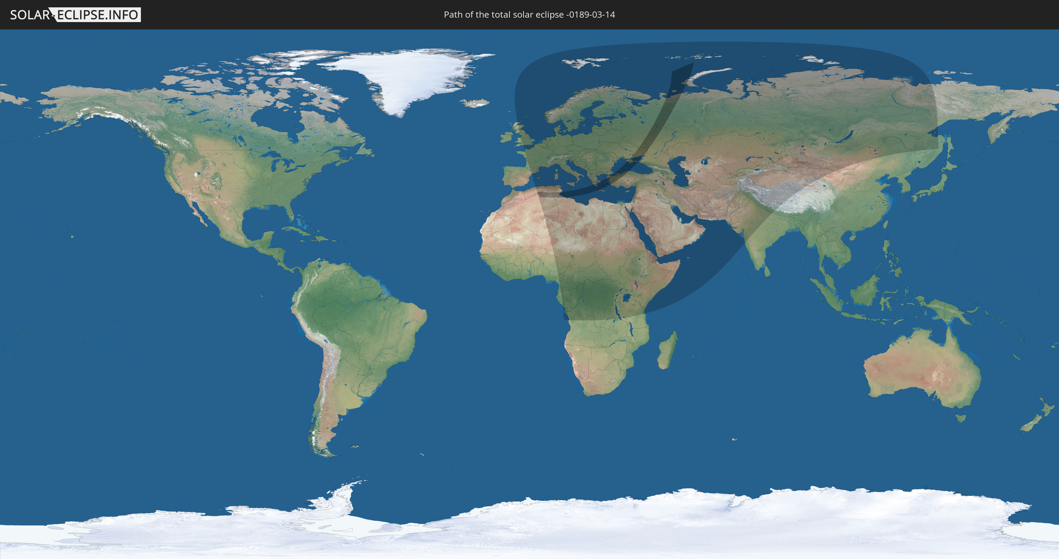
Die Sonnenfinsternis am 14.03.-0189 kann man in 97 Ländern als partielle Sonnenfinsternis beobachten.
Der Finsternispfad verläuft durch 7 Länder. Nur in diesen Ländern ist sie als totale Sonnenfinsternis zu sehen.
In den folgenden Ländern ist die Sonnenfinsternis total zu sehen
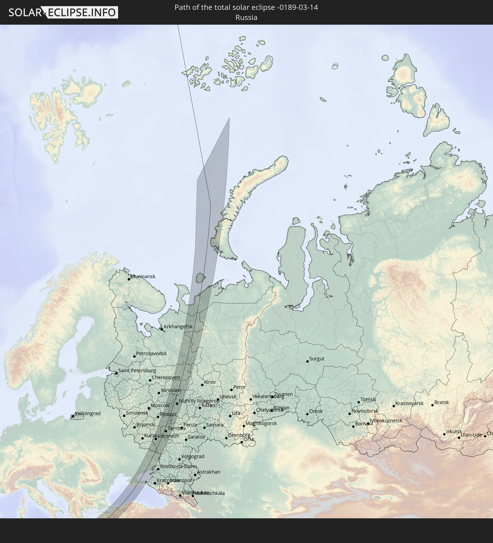 Russland
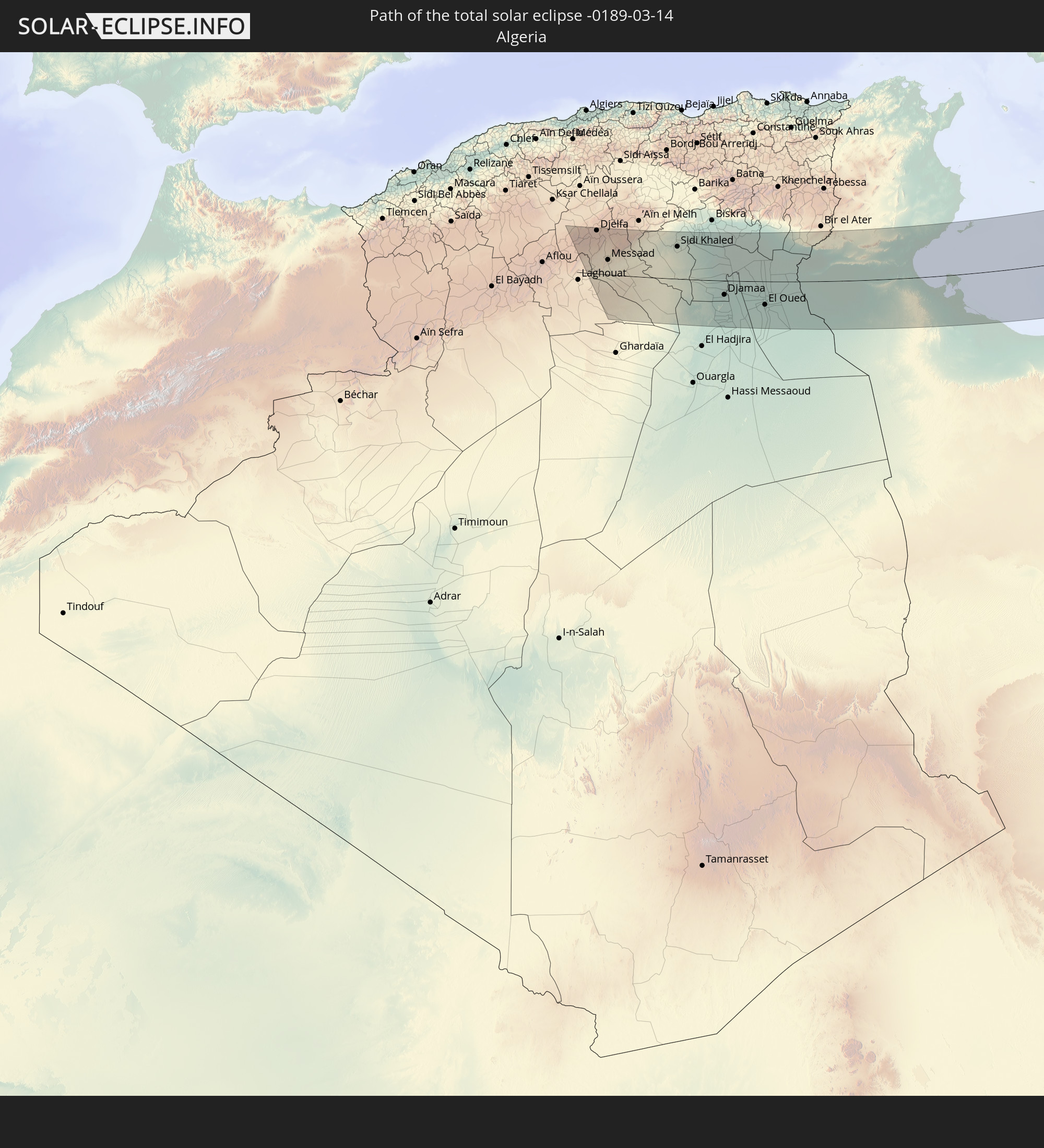 Algerien
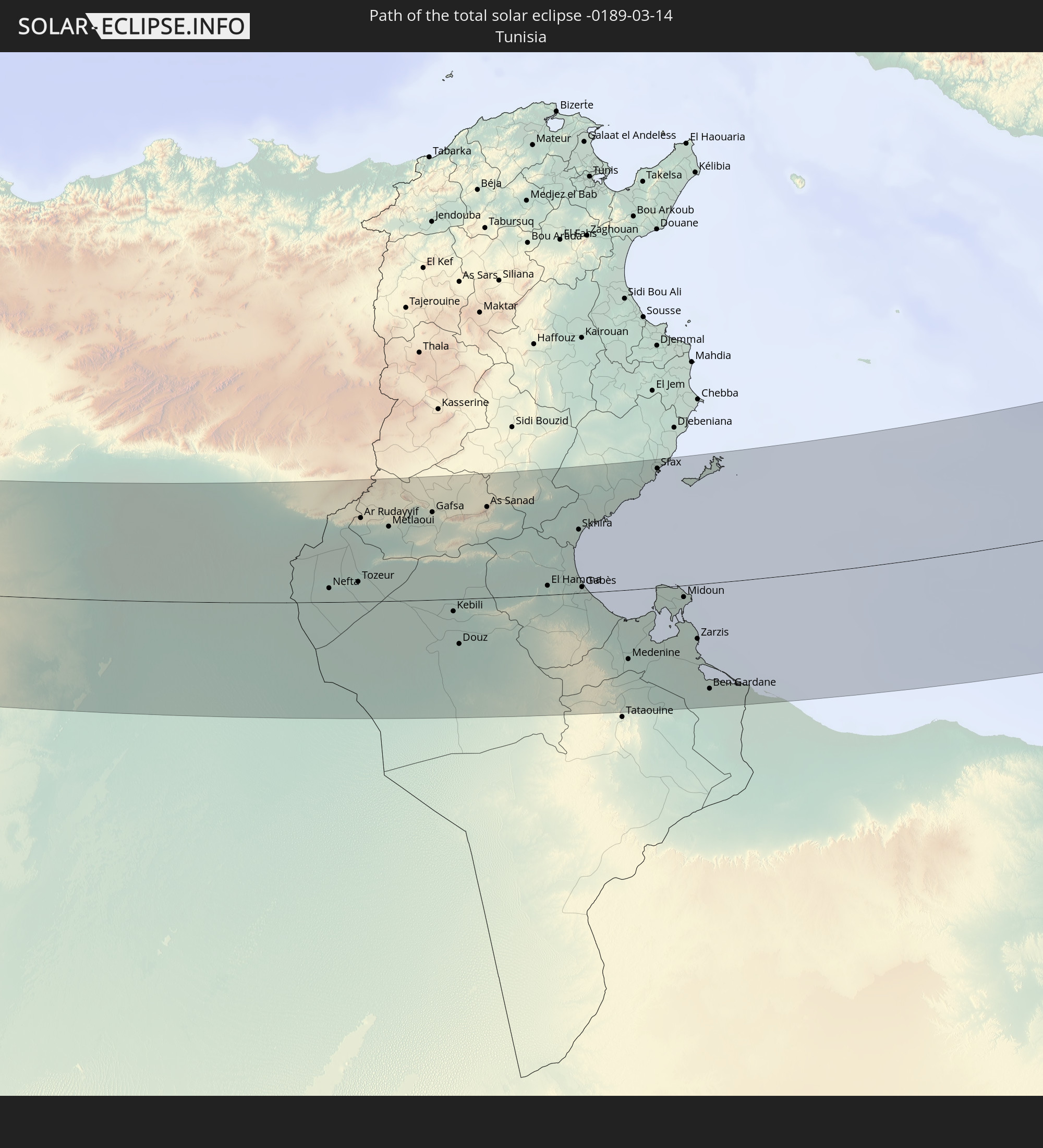 Tunesien
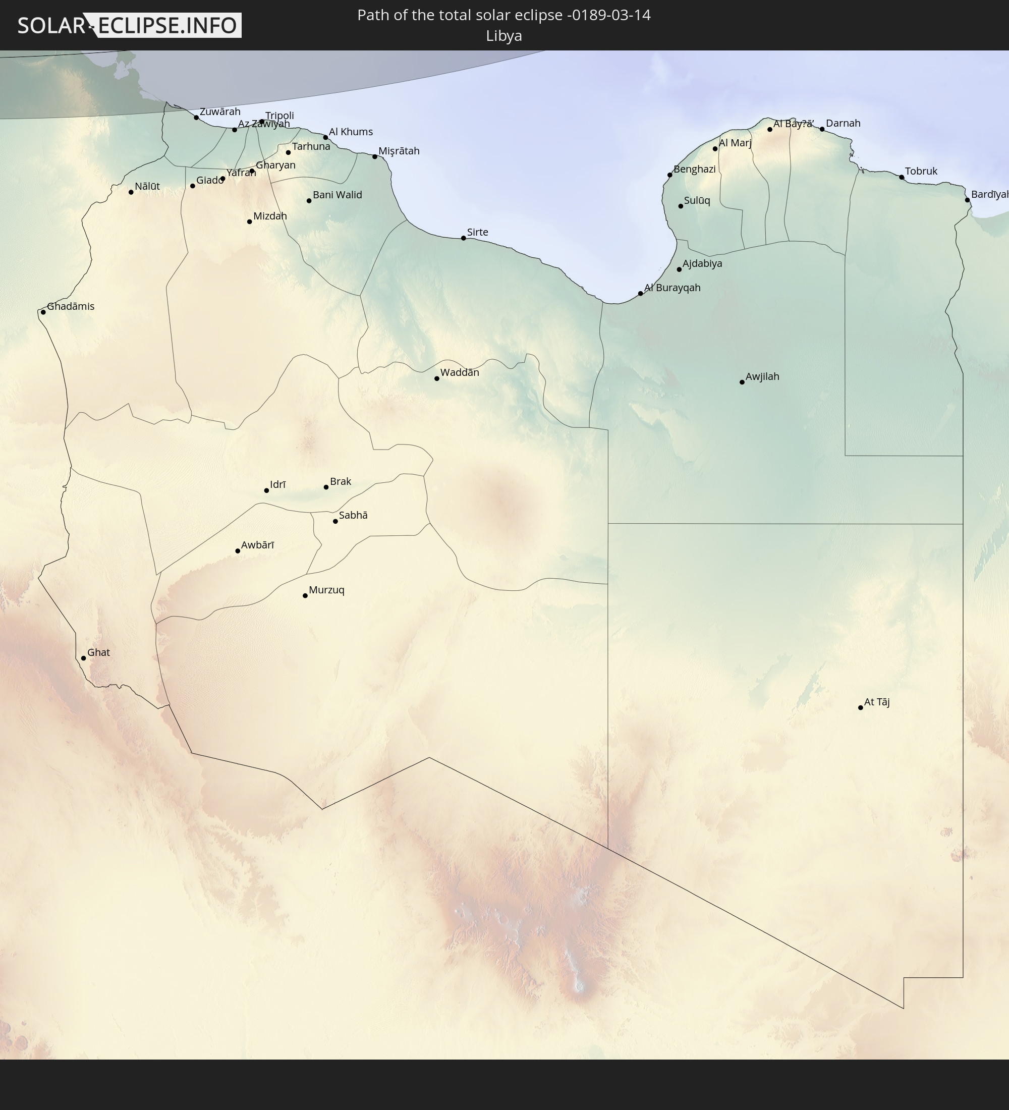 Libyen
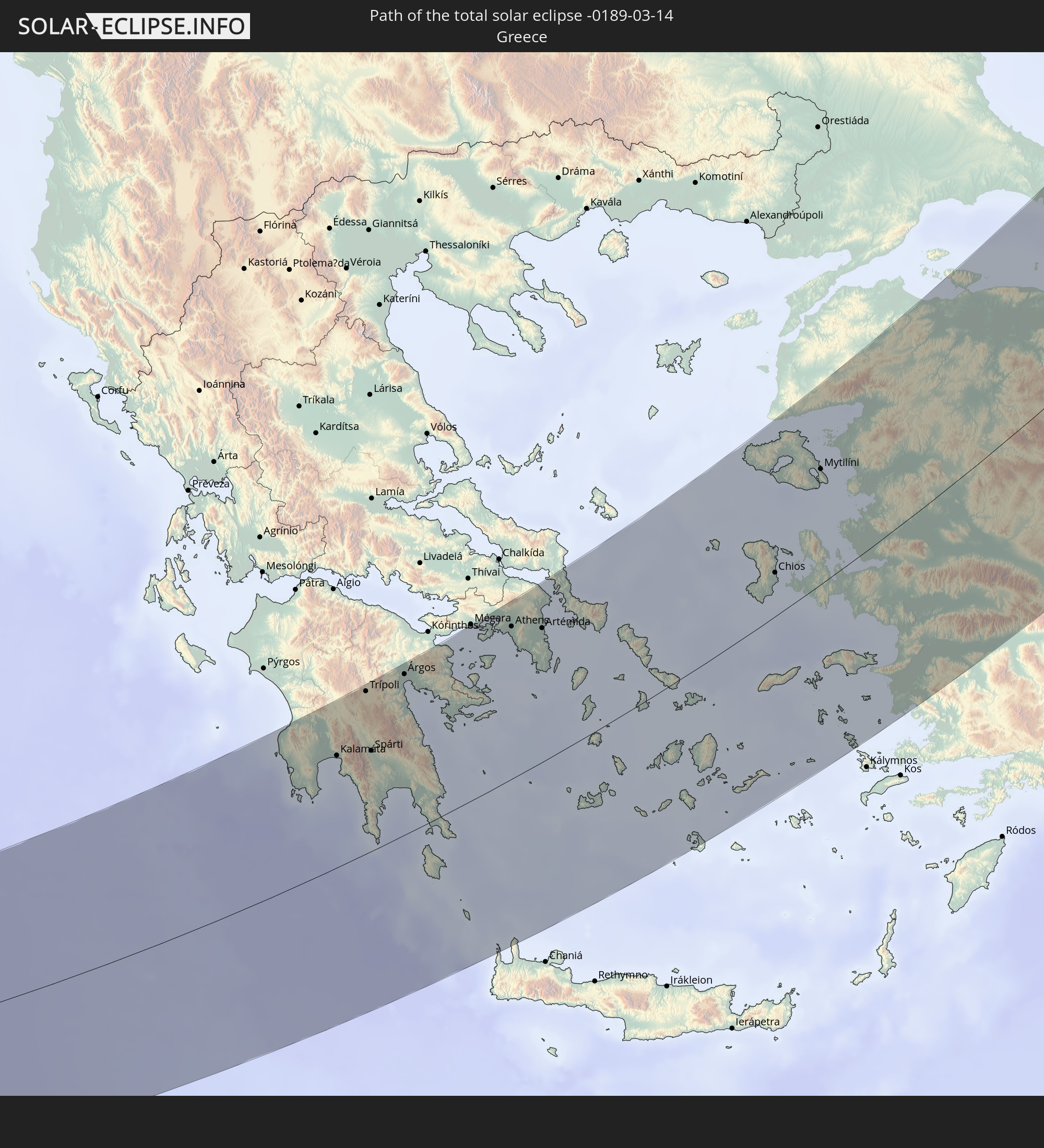 Griechenland
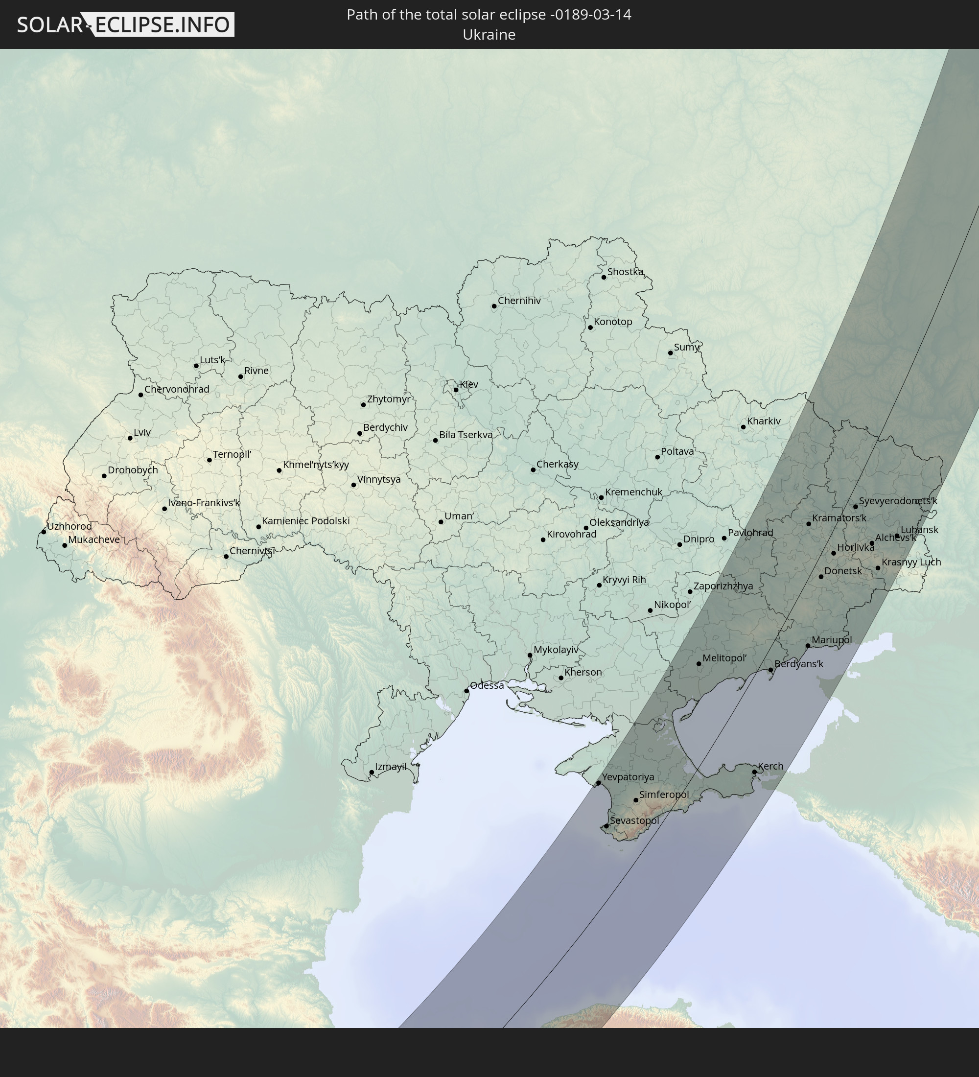 Ukraine
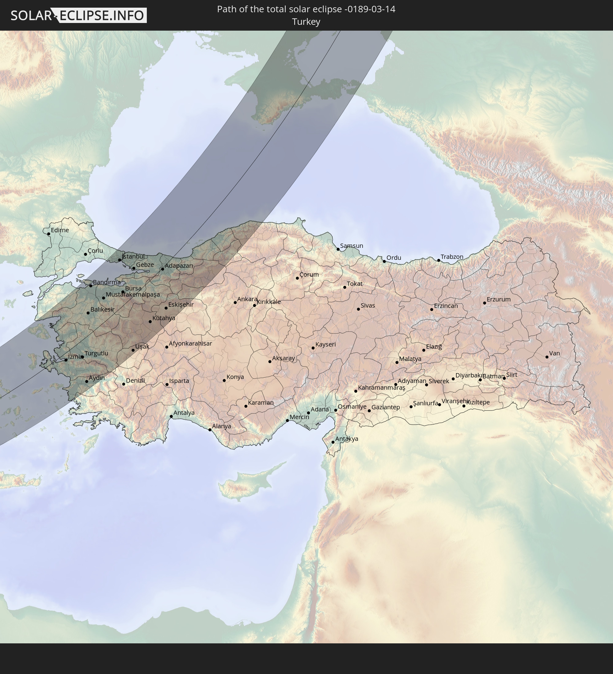 Türkei
In den folgenden Ländern ist die Sonnenfinsternis partiell zu sehen
 Russland
 Spanien
 Spitzbergen
 Algerien
 Vereinigtes Königreich
 Frankreich
 Niger
Niger
 Andorra
 Belgien
 Nigeria
 Niederlande
 Norwegen
 Äquatorialguinea
 Luxemburg
 Deutschland
 Schweiz
 Italien
 Monaco
 Tunesien
 Dänemark
 Kamerun
 Gabun
Gabun
 Libyen
 Liechtenstein
 Österreich
 Schweden
 Republik Kongo
 Angola
 Tschechien
 Demokratische Republik Kongo
 San Marino
 Vatikanstadt
 Slowenien
 Tschad
 Kroatien
 Polen
Polen
 Malta
Malta
 Zentralafrikanische Republik
 Bosnien und Herzegowina
 Ungarn
 Slowakei
 Montenegro
 Serbien
 Albanien
 Åland Islands
 Griechenland
 Rumänien
 Mazedonien
 Finnland
 Litauen
 Lettland
 Estland
 Sudan
Sudan
 Ukraine
 Bulgarien
 Weißrussland
 Ägypten
 Türkei
 Moldawien
 Ruanda
 Burundi
 Tansania
 Uganda
 Republik Zypern
 Äthiopien
 Kenia
Kenia
 Staat Palästina
 Israel
 Saudi-Arabien
 Jordanien
 Libanon
 Syrien
 Eritrea
 Irak
Irak
 Georgien
 Somalia
 Dschibuti
 Jemen
Jemen
 Armenien
 Iran
Iran
 Aserbaidschan
 Kasachstan
 Kuwait
 Bahrain
 Katar
Katar
 Vereinigte Arabische Emirate
 Oman
Oman
 Turkmenistan
 Usbekistan
 Afghanistan
 Pakistan
 Tadschikistan
 Indien
 Kirgisistan
 Volksrepublik China
 Nepal
Nepal
 Mongolei
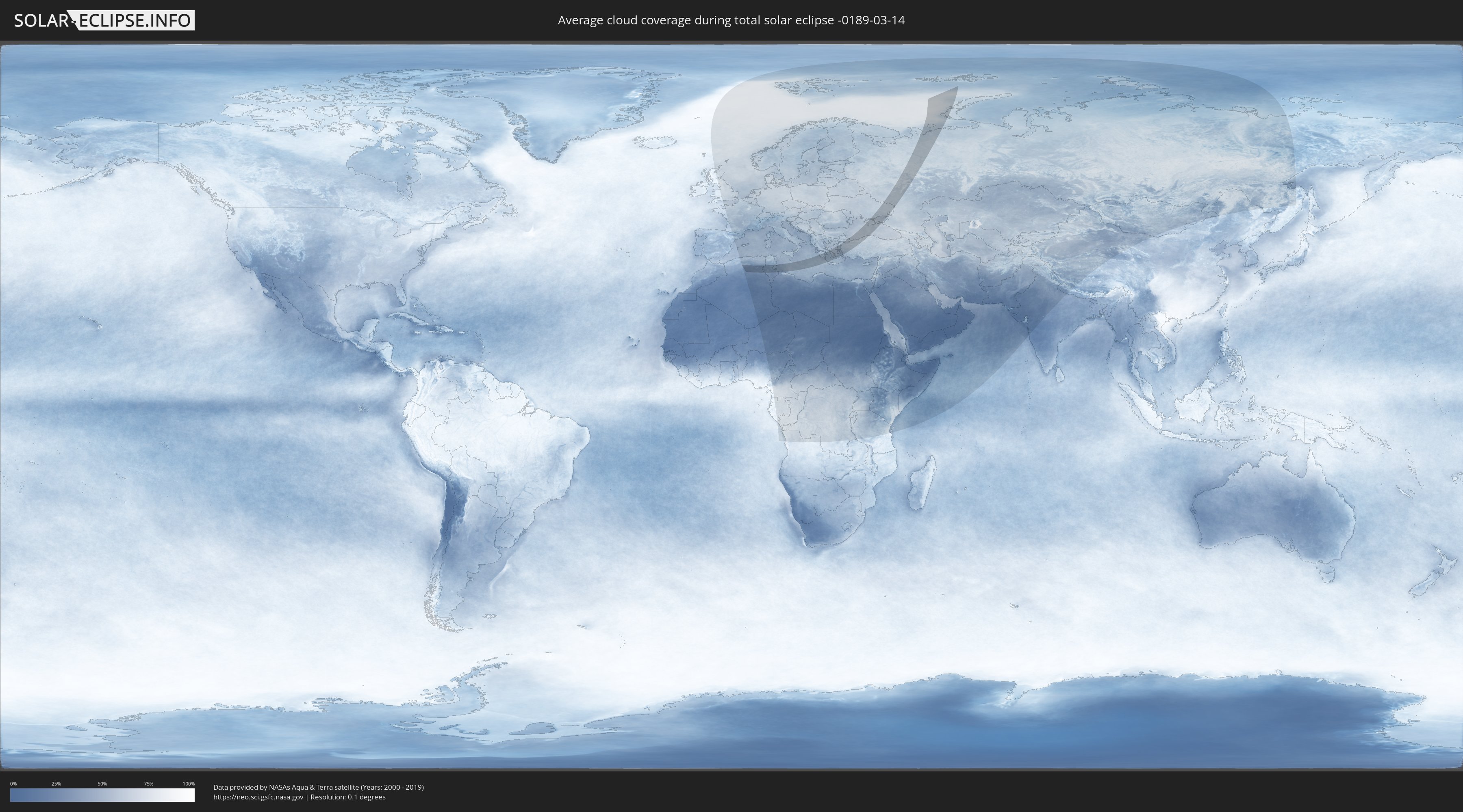
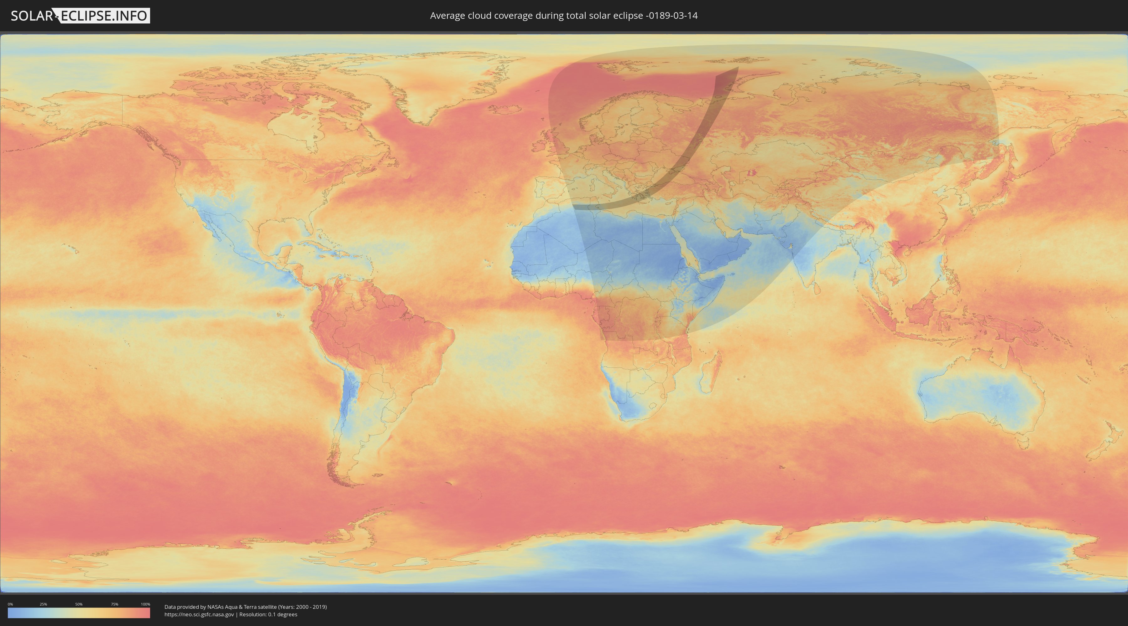
Wie wird das Wetter während der totalen Sonnenfinsternis am 14.03.-0189?
Wo ist der beste Ort, um die totale Sonnenfinsternis vom 14.03.-0189 zu beobachten?
Die folgenden Karten zeigen die durchschnittliche Bewölkung für den Tag, an dem die totale Sonnenfinsternis
stattfindet. Mit Hilfe der Karten lässt sich der Ort entlang des Finsternispfades eingrenzen,
der die besten Aussichen auf einen klaren wolkenfreien Himmel bietet.
Trotzdem muss man immer lokale Gegenenheiten beachten und sollte sich genau über das Wetter an seinem
gewählten Beobachtungsort informieren.
Die Daten stammen von den beiden NASA-Satelliten
AQUA und TERRA
und wurden über einen Zeitraum von 19 Jahren (2000 - 2019) gemittelt.
Detaillierte Länderkarten
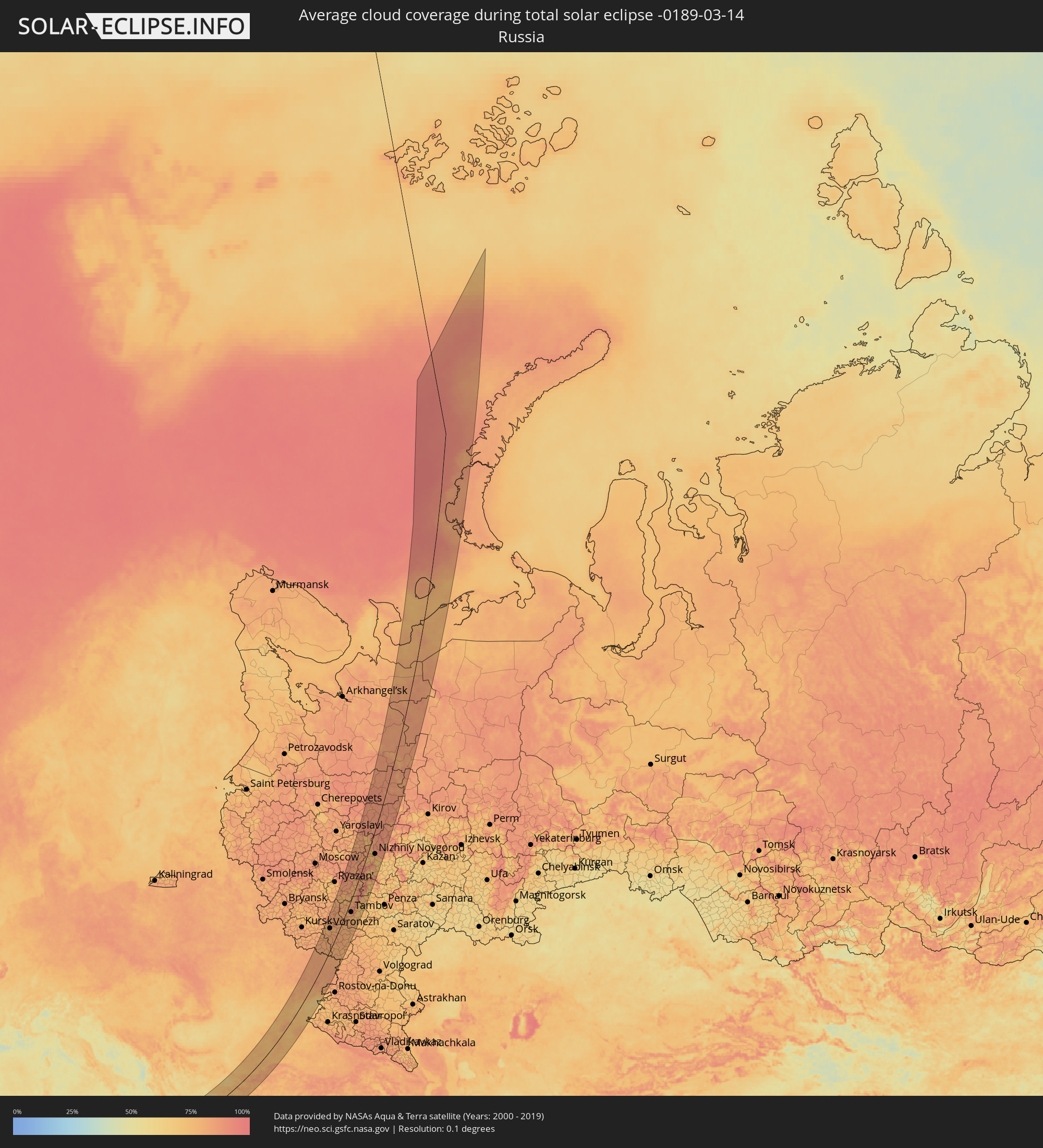 Russland
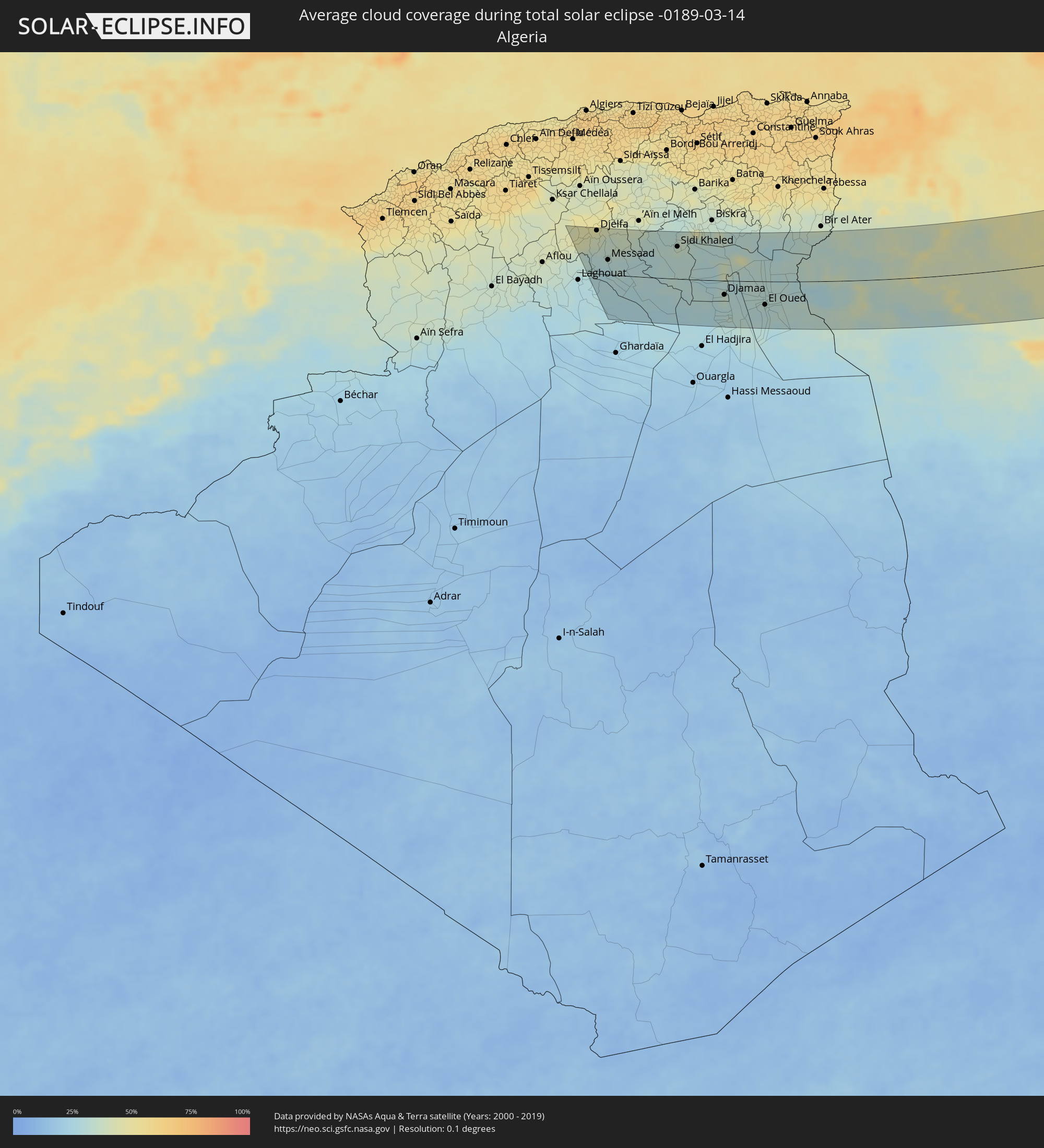 Algerien
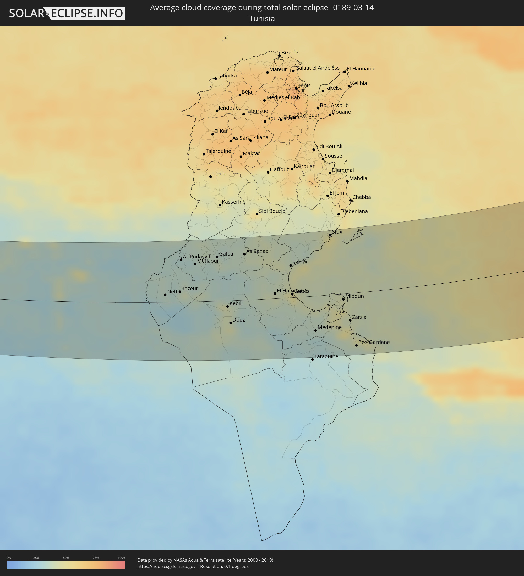 Tunesien
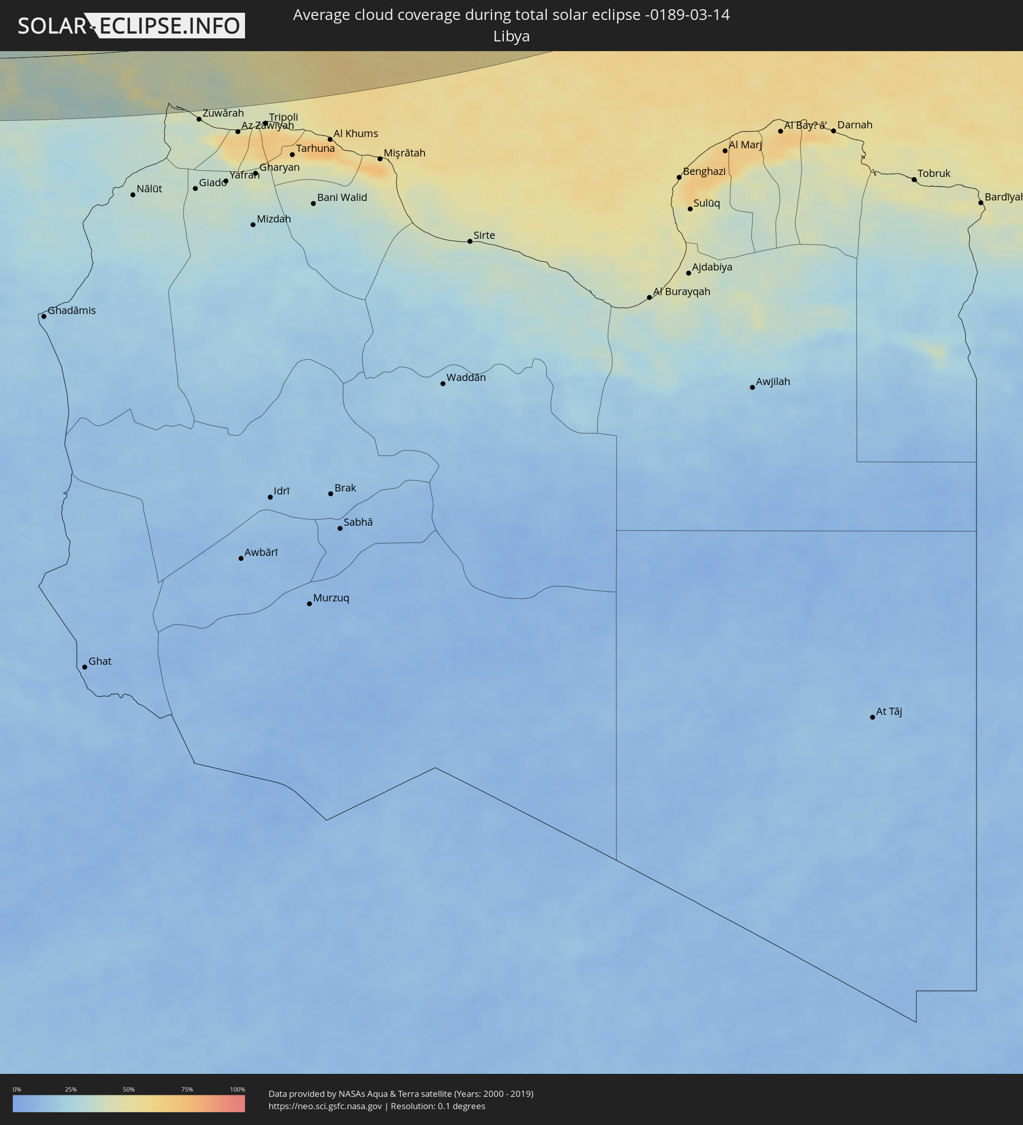 Libyen
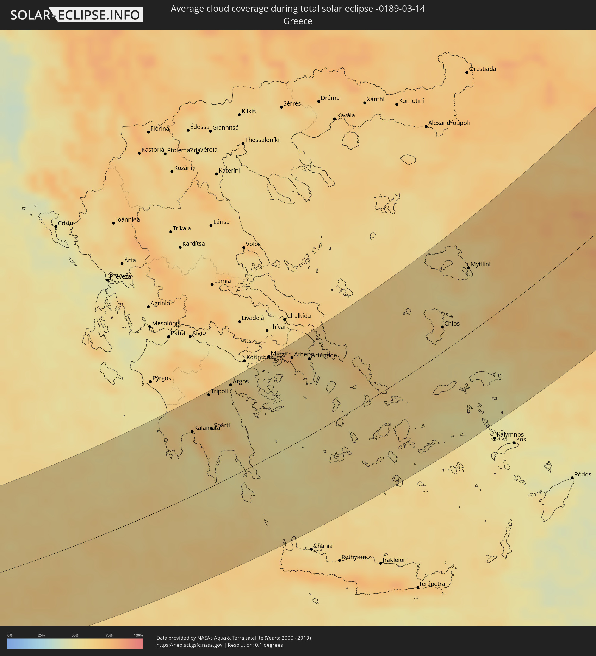 Griechenland
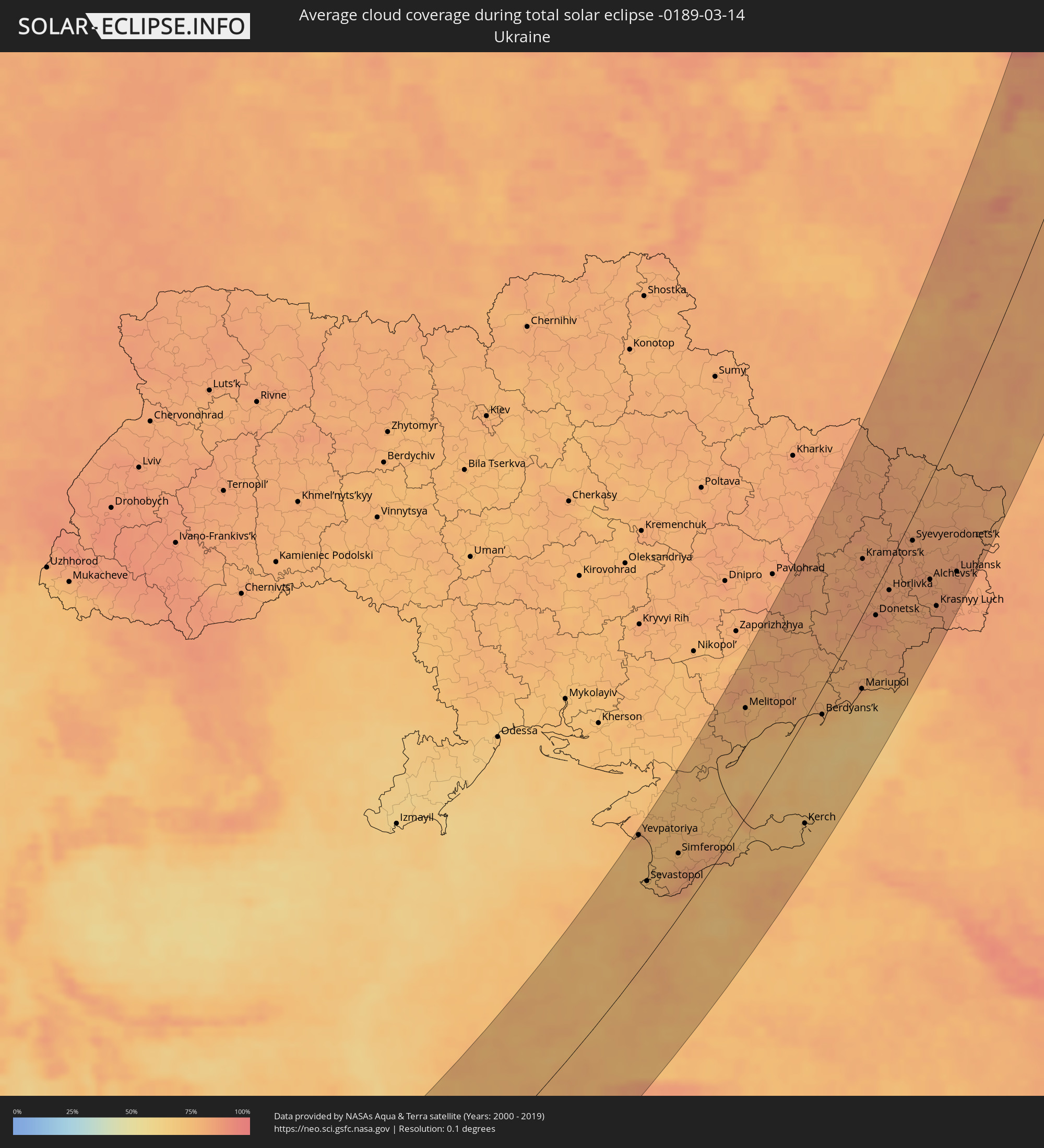 Ukraine
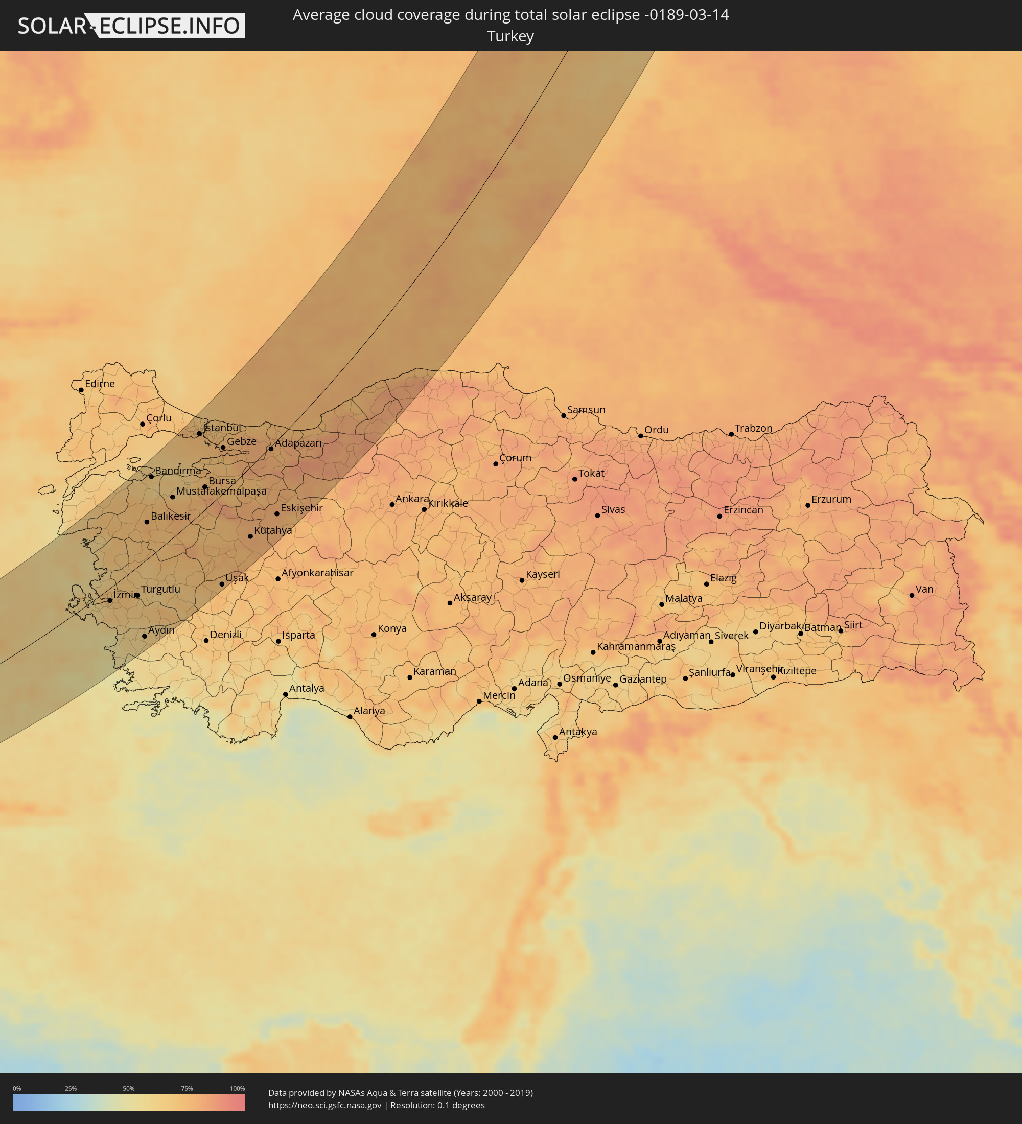 Türkei
Orte im Finsternispfad
Die nachfolgene Tabelle zeigt Städte und Orte mit mehr als 5.000 Einwohnern, die sich im Finsternispfad befinden. Städte mit mehr als 100.000 Einwohnern sind dick gekennzeichnet. Mit einem Klick auf den Ort öffnet sich eine Detailkarte die die Lage des jeweiligen Ortes zusammen mit dem Verlauf der zentralen Finsternis präsentiert.
| Ort | Typ | Dauer der Verfinsterung | Ortszeit bei maximaler Verfinsterung | Entfernung zur Zentrallinie | Ø Bewölkung |
|
Charef, Djelfa
|
total | - | 06:22:02 UTC+00:09 | 76 km | 46% |
|
’Aïn el Bell, Djelfa
|
total | - | 06:21:38 UTC+00:09 | 48 km | 30% |
|
Djelfa, Djelfa
|
total | - | 06:22:12 UTC+00:09 | 85 km | 44% |
|
Messaad, Djelfa
|
total | - | 06:21:21 UTC+00:09 | 29 km | 32% |
|
Sidi Khaled, Biskra
|
total | - | 06:21:59 UTC+00:09 | 63 km | 36% |
|
Djamaa, Ouargla
|
total | - | 06:20:44 UTC+00:09 | 28 km | 33% |
|
Sidi Amrane, Ouargla
|
total | - | 06:20:41 UTC+00:09 | 32 km | 33% |
|
Touggourt, Ouargla
|
total | - | 06:20:01 UTC+00:09 | 75 km | 31% |
|
Tebesbest, Ouargla
|
total | - | 06:20:03 UTC+00:09 | 74 km | 31% |
|
Megarine, Ouargla
|
total | - | 06:20:10 UTC+00:09 | 66 km | 34% |
|
Reguiba, El Oued
|
total | - | 06:20:56 UTC+00:09 | 23 km | 32% |
|
El Oued, El Oued
|
total | - | 06:20:37 UTC+00:09 | 46 km | 31% |
|
Robbah, El Oued
|
total | - | 06:20:30 UTC+00:09 | 55 km | 30% |
|
Debila, El Oued
|
total | - | 06:20:55 UTC+00:09 | 28 km | 31% |
|
Nefta, Tawzar
|
total | - | 06:21:45 UTC+00:09 | 11 km | 34% |
|
Tozeur, Tawzar
|
total | - | 06:21:53 UTC+00:09 | 16 km | 33% |
|
Ar Rudayyif, Gafsa
|
total | - | 06:22:42 UTC+00:09 | 68 km | 32% |
|
Degache, Tawzar
|
total | - | 06:22:01 UTC+00:09 | 22 km | 40% |
|
Metlaoui, Gafsa
|
total | - | 06:22:40 UTC+00:09 | 60 km | 32% |
|
Gafsa, Gafsa
|
total | - | 06:22:57 UTC+00:09 | 71 km | 38% |
|
Kebili, Qibilī
|
total | - | 06:21:45 UTC+00:09 | 10 km | 40% |
|
El Golaa, Qibilī
|
total | - | 06:21:23 UTC+00:09 | 34 km | 44% |
|
Jemna, Qibilī
|
total | - | 06:21:33 UTC+00:09 | 24 km | 40% |
|
Douz, Qibilī
|
total | - | 06:21:21 UTC+00:09 | 37 km | 44% |
|
As Sanad, Gafsa
|
total | - | 06:23:09 UTC+00:09 | 73 km | 40% |
|
El Hamma, Qābis
|
total | - | 06:22:19 UTC+00:09 | 7 km | 41% |
|
Mezzouna, Sīdī Bū Zayd
|
total | - | 06:23:32 UTC+00:09 | 83 km | 39% |
|
Skhira, Şafāqis
|
total | - | 06:23:07 UTC+00:09 | 51 km | 45% |
|
Gabès, Qābis
|
total | - | 06:22:24 UTC+00:09 | 5 km | 47% |
|
Medenine, Madanīn
|
total | - | 06:21:37 UTC+00:09 | 56 km | 34% |
|
Sfax, Şafāqis
|
total | - | 06:24:08 UTC+00:09 | 96 km | 46% |
|
Gremda, Şafāqis
|
total | - | 06:24:09 UTC+00:09 | 97 km | 49% |
|
Houmt Souk, Madanīn
|
total | - | 06:22:38 UTC+00:09 | 1 km | 44% |
|
Midoun, Madanīn
|
total | - | 06:22:34 UTC+00:09 | 9 km | 43% |
|
Zarzis, Madanīn
|
total | - | 06:22:04 UTC+00:09 | 44 km | 47% |
|
Ben Gardane, Madanīn
|
total | - | 06:21:28 UTC+00:09 | 86 km | 35% |
|
Filiatrá, Peloponnese
|
total | - | 07:59:37 UTC+01:34 | 115 km | 57% |
|
Gargaliánoi, Peloponnese
|
total | - | 07:59:29 UTC+01:34 | 104 km | 57% |
|
Messíni, Peloponnese
|
total | - | 07:59:42 UTC+01:34 | 88 km | 58% |
|
Kalamáta, Peloponnese
|
total | - | 07:59:45 UTC+01:34 | 83 km | 54% |
|
Trípoli, Peloponnese
|
total | - | 08:00:50 UTC+01:34 | 119 km | 64% |
|
Spárti, Peloponnese
|
total | - | 08:00:03 UTC+01:34 | 74 km | 63% |
|
Árgos, Peloponnese
|
total | - | 08:01:19 UTC+01:34 | 116 km | 57% |
|
Néa Péramos, Attica
|
total | - | 08:02:31 UTC+01:34 | 123 km | 61% |
|
Aegina, Attica
|
total | - | 08:02:02 UTC+01:34 | 98 km | 55% |
|
Salamína, Attica
|
total | - | 08:02:30 UTC+01:34 | 116 km | 60% |
|
Athens, Attica
|
total | - | 08:02:41 UTC+01:34 | 108 km | 68% |
|
Zefyri, Attica
|
total | - | 08:02:51 UTC+01:34 | 116 km | 75% |
|
Néa Chalkidóna, Attica
|
total | - | 08:02:47 UTC+01:34 | 112 km | 68% |
|
Psychikó, Attica
|
total | - | 08:02:48 UTC+01:34 | 108 km | 69% |
|
Voúla, Attica
|
total | - | 08:02:28 UTC+01:34 | 92 km | 58% |
|
Lykóvrysi, Attica
|
total | - | 08:02:54 UTC+01:34 | 113 km | 72% |
|
Filothéi, Attica
|
total | - | 08:02:49 UTC+01:34 | 109 km | 69% |
|
Néa Erythraía, Attica
|
total | - | 08:02:59 UTC+01:34 | 114 km | 72% |
|
Ágios Stéfanos, Attica
|
total | - | 08:03:07 UTC+01:34 | 117 km | 67% |
|
Anoixi, Attica
|
total | - | 08:03:05 UTC+01:34 | 116 km | 67% |
|
Néa Pentéli, Attica
|
total | - | 08:02:57 UTC+01:34 | 109 km | 67% |
|
Drosiá, Attica
|
total | - | 08:03:04 UTC+01:34 | 114 km | 67% |
|
Spáta, Attica
|
total | - | 08:02:48 UTC+01:34 | 97 km | 67% |
|
Markópoulo, Attica
|
total | - | 08:02:40 UTC+01:34 | 89 km | 65% |
|
Marathónas, Attica
|
total | - | 08:03:12 UTC+01:34 | 113 km | 62% |
|
Keratéa, Attica
|
total | - | 08:02:33 UTC+01:34 | 79 km | 61% |
|
Artémida, Attica
|
total | - | 08:02:52 UTC+01:34 | 94 km | 63% |
|
Limín Mesoyaías, Attica
|
total | - | 08:02:44 UTC+01:34 | 86 km | 61% |
|
Lávrio, Attica
|
total | - | 08:02:26 UTC+01:34 | 67 km | 60% |
|
Ermoúpolis, South Aegean
|
total | - | 08:02:35 UTC+01:34 | 1 km | 59% |
|
Náxos, South Aegean
|
total | - | 08:02:17 UTC+01:34 | 52 km | 62% |
|
Chios, North Aegean
|
total | - | 08:05:18 UTC+01:34 | 29 km | 65% |
|
Mytilíni, North Aegean
|
total | - | 08:07:03 UTC+01:34 | 74 km | 57% |
|
Néon Karlovásion, North Aegean
|
total | - | 08:04:39 UTC+01:34 | 52 km | 56% |
|
Menemen, İzmir
|
total | - | 08:28:35 UTC+01:56 | 2 km | 69% |
|
İzmir, İzmir
|
total | - | 08:28:16 UTC+01:56 | 19 km | 66% |
|
Bergama, İzmir
|
total | - | 08:29:39 UTC+01:56 | 42 km | 67% |
|
Kuşadası, Aydın
|
total | - | 08:27:18 UTC+01:56 | 75 km | 57% |
|
Söke, Aydın
|
total | - | 08:27:13 UTC+01:56 | 92 km | 57% |
|
Manisa, Manisa
|
total | - | 08:28:53 UTC+01:56 | 16 km | 72% |
|
Soma, Manisa
|
total | - | 08:30:08 UTC+01:56 | 24 km | 72% |
|
Turgutlu, Manisa
|
total | - | 08:28:53 UTC+01:56 | 41 km | 67% |
|
Aydın, Aydın
|
total | - | 08:27:46 UTC+01:56 | 106 km | 58% |
|
Akhisar, Manisa
|
total | - | 08:29:49 UTC+01:56 | 11 km | 64% |
|
Balıkesir, Balıkesir
|
total | - | 08:31:16 UTC+01:56 | 49 km | 73% |
|
Ödemiş, İzmir
|
total | - | 08:28:36 UTC+01:56 | 79 km | 63% |
|
Bandırma, Balıkesir
|
total | - | 08:32:41 UTC+01:56 | 103 km | 66% |
|
Salihli, Manisa
|
total | - | 08:29:15 UTC+01:56 | 66 km | 66% |
|
Mustafakemalpaşa, Bursa
|
total | - | 08:32:27 UTC+01:56 | 52 km | 75% |
|
Esenyurt, Istanbul
|
total | - | 08:34:35 UTC+01:56 | 118 km | 73% |
|
İstanbul, Istanbul
|
total | - | 08:34:48 UTC+01:56 | 101 km | 74% |
|
Bursa, Bursa
|
total | - | 08:33:20 UTC+01:56 | 28 km | 79% |
|
Maltepe, Istanbul
|
total | - | 08:34:50 UTC+01:56 | 82 km | 74% |
|
Gemlik, Bursa
|
total | - | 08:33:52 UTC+01:56 | 42 km | 74% |
|
Yalova, Yalova
|
total | - | 08:34:24 UTC+01:56 | 53 km | 71% |
|
Uşak, Uşak
|
total | - | 08:30:43 UTC+01:56 | 119 km | 73% |
|
Gebze, Kocaeli
|
total | - | 08:34:49 UTC+01:56 | 55 km | 74% |
|
İnegol, Bursa
|
total | - | 08:33:30 UTC+01:56 | 8 km | 74% |
|
İzmit, Kocaeli
|
total | - | 08:35:11 UTC+01:56 | 24 km | 78% |
|
Kütahya, Kütahya
|
total | - | 08:32:40 UTC+01:56 | 89 km | 78% |
|
Bozüyük, Bilecik
|
total | - | 08:33:39 UTC+01:56 | 52 km | 79% |
|
Adapazarı, Sakarya
|
total | - | 08:35:39 UTC+01:56 | 4 km | 78% |
|
Eskişehir, Eskişehir
|
total | - | 08:33:50 UTC+01:56 | 91 km | 78% |
|
Düzce, Düzce
|
total | - | 08:36:28 UTC+01:56 | 46 km | 81% |
|
Ereğli, Zonguldak
|
total | - | 08:37:33 UTC+01:56 | 27 km | 73% |
|
Bolu, Bolu
|
total | - | 08:36:40 UTC+01:56 | 80 km | 82% |
|
Zonguldak, Zonguldak
|
total | - | 08:38:13 UTC+01:56 | 38 km | 76% |
|
Karabük, Karabük
|
total | - | 08:38:32 UTC+01:56 | 108 km | 77% |
|
Yevpatoriya, Republic of Crimea
|
total | - | 09:05:50 UTC+02:16 | 117 km | 76% |
|
Sevastopol, Gorod Sevastopol
|
total | - | 09:04:51 UTC+02:16 | 68 km | 73% |
|
Saki, Republic of Crimea
|
total | - | 09:05:56 UTC+02:16 | 97 km | 73% |
|
Simferopol, Republic of Crimea
|
total | - | 09:06:06 UTC+02:16 | 53 km | 78% |
|
Yalta, Republic of Crimea
|
total | - | 09:05:18 UTC+02:16 | 21 km | 77% |
|
Dzhankoy, Republic of Crimea
|
total | - | 09:07:46 UTC+02:16 | 80 km | 75% |
|
Alushta, Republic of Crimea
|
total | - | 09:05:52 UTC+02:16 | 16 km | 78% |
|
Melitopol’, Zaporizhia
|
total | - | 08:56:51 UTC+02:02 | 81 km | 78% |
|
Feodosiya, Republic of Crimea
|
total | - | 09:07:29 UTC+02:16 | 25 km | 74% |
|
Tokmak, Zaporizhia
|
total | - | 08:57:55 UTC+02:02 | 80 km | 77% |
|
Kerch, Republic of Crimea
|
total | - | 09:09:09 UTC+02:16 | 79 km | 70% |
|
Berdyans’k, Zaporizhia
|
total | - | 08:58:06 UTC+02:02 | 18 km | 74% |
|
Dobropillya, Donetsk
|
total | - | 09:01:24 UTC+02:02 | 53 km | 84% |
|
Krasnoarmiys’k, Donetsk
|
total | - | 09:01:11 UTC+02:02 | 38 km | 83% |
|
Izyum, Kharkiv
|
total | - | 09:02:52 UTC+02:02 | 79 km | 81% |
|
Mariupol, Donetsk
|
total | - | 08:59:26 UTC+02:02 | 49 km | 76% |
|
Kramators’k, Donetsk
|
total | - | 09:02:20 UTC+02:02 | 35 km | 84% |
|
Kupjansk, Kharkiv
|
total | - | 09:04:06 UTC+02:02 | 79 km | 82% |
|
Sloviansk, Donetsk
|
total | - | 09:02:38 UTC+02:02 | 38 km | 82% |
|
Kostyantynivka, Donetsk
|
total | - | 09:02:08 UTC+02:02 | 15 km | 82% |
|
Donetsk, Donetsk
|
total | - | 09:01:21 UTC+02:02 | 17 km | 86% |
|
Dzerzhyns’k, Donetsk
|
total | - | 09:02:03 UTC+02:02 | 1 km | 81% |
|
Artemivs’k, Donetsk
|
total | - | 09:02:33 UTC+02:02 | 1 km | 81% |
|
Horlivka, Donetsk
|
total | - | 09:02:09 UTC+02:02 | 17 km | 83% |
|
Valuyki, Belgorod
|
total | - | 09:33:38 UTC+02:30 | 70 km | 82% |
|
Khartsyz’k, Donetsk
|
total | - | 09:01:43 UTC+02:02 | 38 km | 81% |
|
Yenakiyeve, Donetsk
|
total | - | 09:02:07 UTC+02:02 | 33 km | 81% |
|
Debal’tseve, Donetsk
|
total | - | 09:02:30 UTC+02:02 | 40 km | 82% |
|
Shakhtars’k, Donetsk
|
total | - | 09:02:02 UTC+02:02 | 57 km | 79% |
|
Syevyerodonets’k, Luhansk
|
total | - | 09:03:39 UTC+02:02 | 15 km | 82% |
|
Rossosh’, Voronezj
|
total | - | 09:35:35 UTC+02:30 | 85 km | 79% |
|
Stakhanov, Luhansk
|
total | - | 09:03:08 UTC+02:02 | 44 km | 85% |
|
Alekseyevka, Belgorod
|
total | - | 09:34:56 UTC+02:30 | 52 km | 79% |
|
Snizhne, Donetsk
|
total | - | 09:02:19 UTC+02:02 | 80 km | 82% |
|
Alchevs’k, Luhansk
|
total | - | 09:03:08 UTC+02:02 | 60 km | 84% |
|
Krasnyy Luch, Luhansk
|
total | - | 09:02:41 UTC+02:02 | 85 km | 83% |
|
Ostrogozhsk, Voronezj
|
total | - | 09:35:42 UTC+02:30 | 38 km | 81% |
|
Voronezh, Voronezj
|
total | - | 09:37:09 UTC+02:30 | 66 km | 80% |
|
Novovoronezh, Voronezj
|
total | - | 09:36:35 UTC+02:30 | 48 km | 81% |
|
Luhansk, Luhansk
|
total | - | 09:03:49 UTC+02:02 | 88 km | 85% |
|
Liski, Voronezj
|
total | - | 09:36:20 UTC+02:30 | 15 km | 82% |
|
Rossosh’, Voronezj
|
total | - | 09:35:04 UTC+02:30 | 25 km | 79% |
|
Lipetsk, Lipetsk
|
total | - | 09:39:03 UTC+02:30 | 80 km | 86% |
|
Gryazi, Lipetsk
|
total | - | 09:39:13 UTC+02:30 | 53 km | 81% |
|
Michurinsk, Tambov
|
total | - | 09:40:24 UTC+02:30 | 34 km | 83% |
|
Kasimov, Rjazan
|
total | - | 09:44:26 UTC+02:30 | 57 km | 83% |
|
Tambov, Tambov
|
total | - | 09:41:03 UTC+02:30 | 32 km | 81% |
|
Kotovsk, Tambov
|
total | - | 09:40:53 UTC+02:30 | 42 km | 83% |
|
Morshansk, Tambov
|
total | - | 09:42:31 UTC+02:30 | 26 km | 84% |
|
Rasskazovo, Tambov
|
total | - | 09:41:21 UTC+02:30 | 63 km | 79% |
|
Vichuga, Ivanovo
|
total | - | 09:48:18 UTC+02:30 | 102 km | 80% |
|
Murom, Vladimir
|
total | - | 09:45:59 UTC+02:30 | 41 km | 81% |
|
Kineshma, Ivanovo
|
total | - | 09:48:48 UTC+02:30 | 97 km | 85% |
|
Vyazniki, Vladimir
|
total | - | 09:47:05 UTC+02:30 | 57 km | 82% |
|
Vyksa, Nizjnij Novgorod
|
total | - | 09:45:44 UTC+02:30 | 23 km | 87% |
|
Kulebaki, Nizjnij Novgorod
|
total | - | 09:46:12 UTC+02:30 | 6 km | 91% |
|
Pavlovo, Nizjnij Novgorod
|
total | - | 09:47:32 UTC+02:30 | 8 km | 76% |
|
Sarov, Nizjnij Novgorod
|
total | - | 09:46:14 UTC+02:30 | 60 km | 88% |
|
Zavolzh’ye, Nizjnij Novgorod
|
total | - | 09:48:47 UTC+02:30 | 2 km | 80% |
|
Dzerzhinsk, Nizjnij Novgorod
|
total | - | 09:48:16 UTC+02:30 | 19 km | 75% |
|
Bogorodsk, Nizjnij Novgorod
|
total | - | 09:48:07 UTC+02:30 | 28 km | 73% |
|
Novaya Balakhna, Nizjnij Novgorod
|
total | - | 09:48:45 UTC+02:30 | 19 km | 80% |
|
Arzamas, Nizjnij Novgorod
|
total | - | 09:47:24 UTC+02:30 | 73 km | 75% |
|
Nizhniy Novgorod, Nizjnij Novgorod
|
total | - | 09:48:54 UTC+02:30 | 48 km | 80% |
|
Kstovo, Nizjnij Novgorod
|
total | - | 09:48:49 UTC+02:30 | 66 km | 77% |
|
Velikiy Ustyug, Vologda
|
total | - | 09:56:49 UTC+02:30 | 33 km | 77% |
|
Kotlas, Arkhangelskaya
|
total | - | 09:57:42 UTC+02:30 | 36 km | 76% |
|
Koryazhma, Arkhangelskaya
|
total | - | 09:58:11 UTC+02:30 | 61 km | 85% |