Totale Sonnenfinsternis vom 28.01.-0383
| Wochentag: | Donnerstag |
| Maximale Dauer der Verfinsterung: | 03m49s |
| Maximale Breite des Finsternispfades: | 274 km |
| Saroszyklus: | 44 |
| Bedeckungsgrad: | 100% |
| Magnitude: | 1.0456 |
| Gamma: | 0.832 |
Wo kann man die Sonnenfinsternis vom 28.01.-0383 sehen?
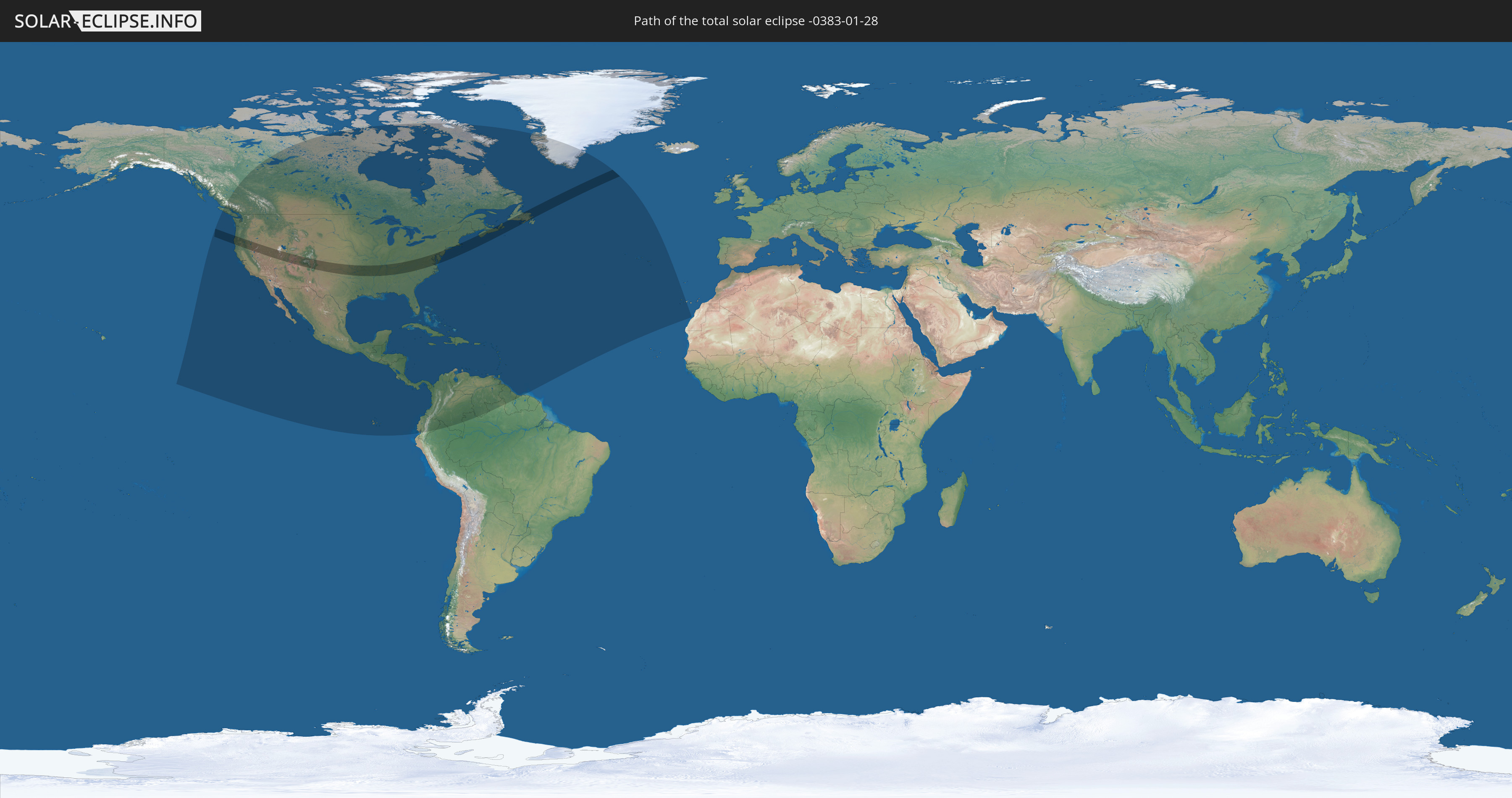
Die Sonnenfinsternis am 28.01.-0383 kann man in 48 Ländern als partielle Sonnenfinsternis beobachten.
Der Finsternispfad verläuft durch 3 Länder. Nur in diesen Ländern ist sie als totale Sonnenfinsternis zu sehen.
In den folgenden Ländern ist die Sonnenfinsternis total zu sehen
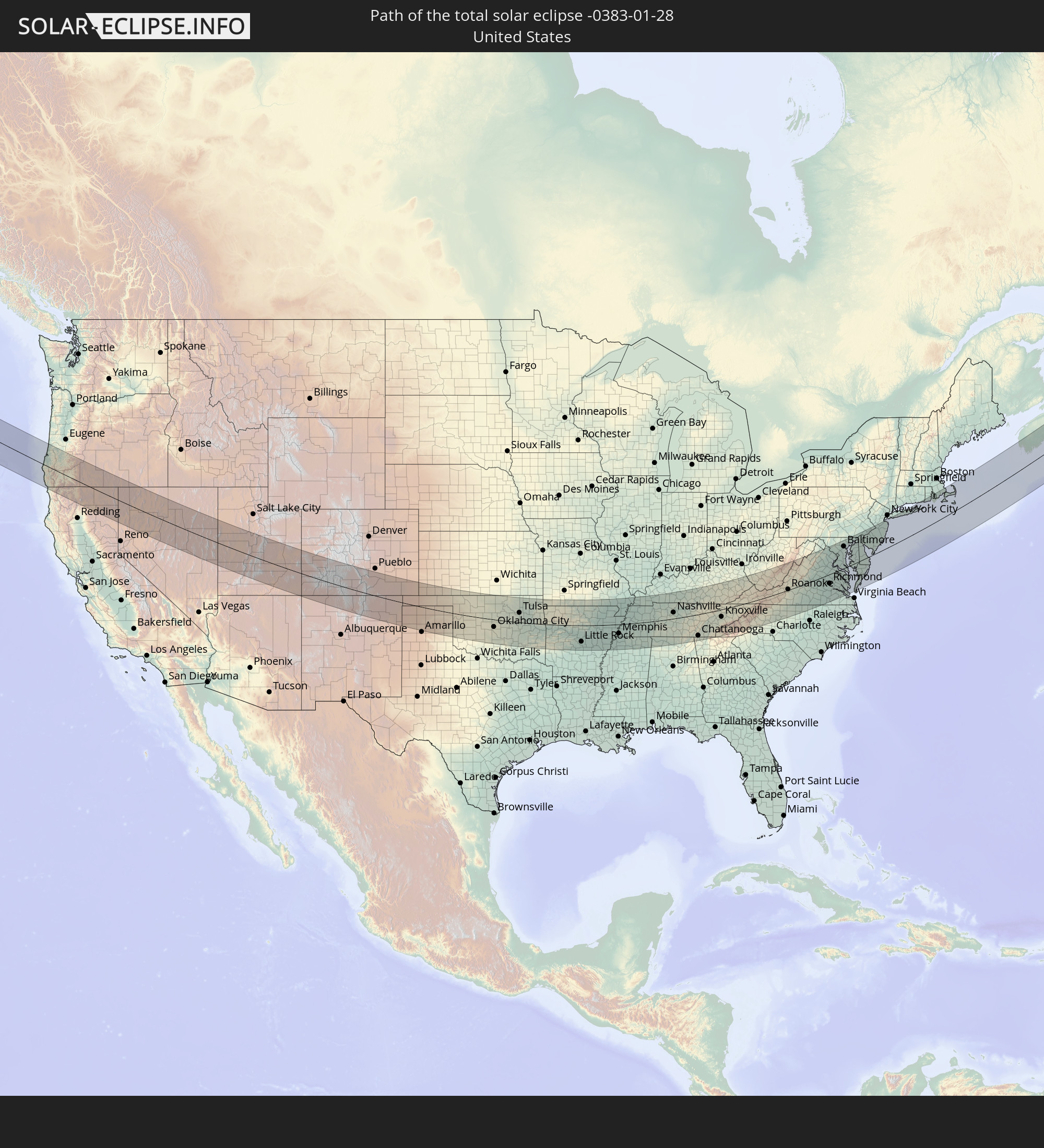 Vereinigte Staaten
 Kanada
 Saint-Pierre und Miquelon
In den folgenden Ländern ist die Sonnenfinsternis partiell zu sehen
 Vereinigte Staaten
 United States Minor Outlying Islands
 Kanada
 Mexiko
 Grönland
 Guatemala
 Ecuador
 El Salvador
 Honduras
 Belize
 Nicaragua
 Costa Rica
 Kuba
Kuba
 Panama
 Kolumbien
 Kaimaninseln
 Peru
Peru
 Bahamas
 Jamaika
 Haiti
Haiti
 Brasilien
 Venezuela
 Turks- und Caicosinseln
 Dominikanische Republik
 Aruba
Aruba
 Puerto Rico
 Amerikanische Jungferninseln
 Bermuda
 Britische Jungferninseln
 Anguilla
 Saint-Martin
 Saint-Barthélemy
 St. Kitts und Nevis
 Antigua und Barbuda
 Montserrat
 Trinidad und Tobago
 Guadeloupe
 Grenada
 Dominica
 St. Vincent und die Grenadinen
 Guyana
 Martinique
 St. Lucia
 Barbados
 Suriname
 Saint-Pierre und Miquelon
 Portugal
 Spanien
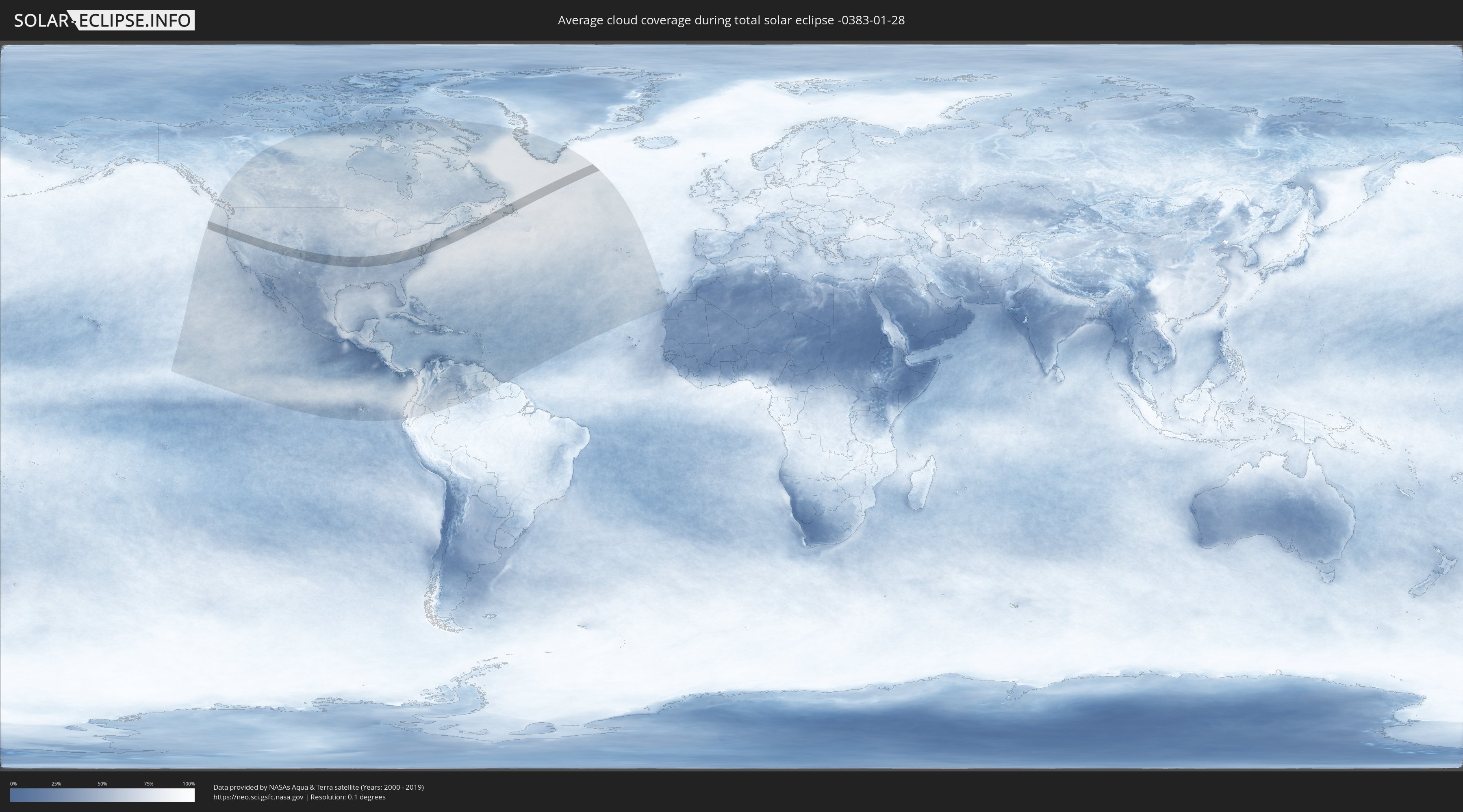
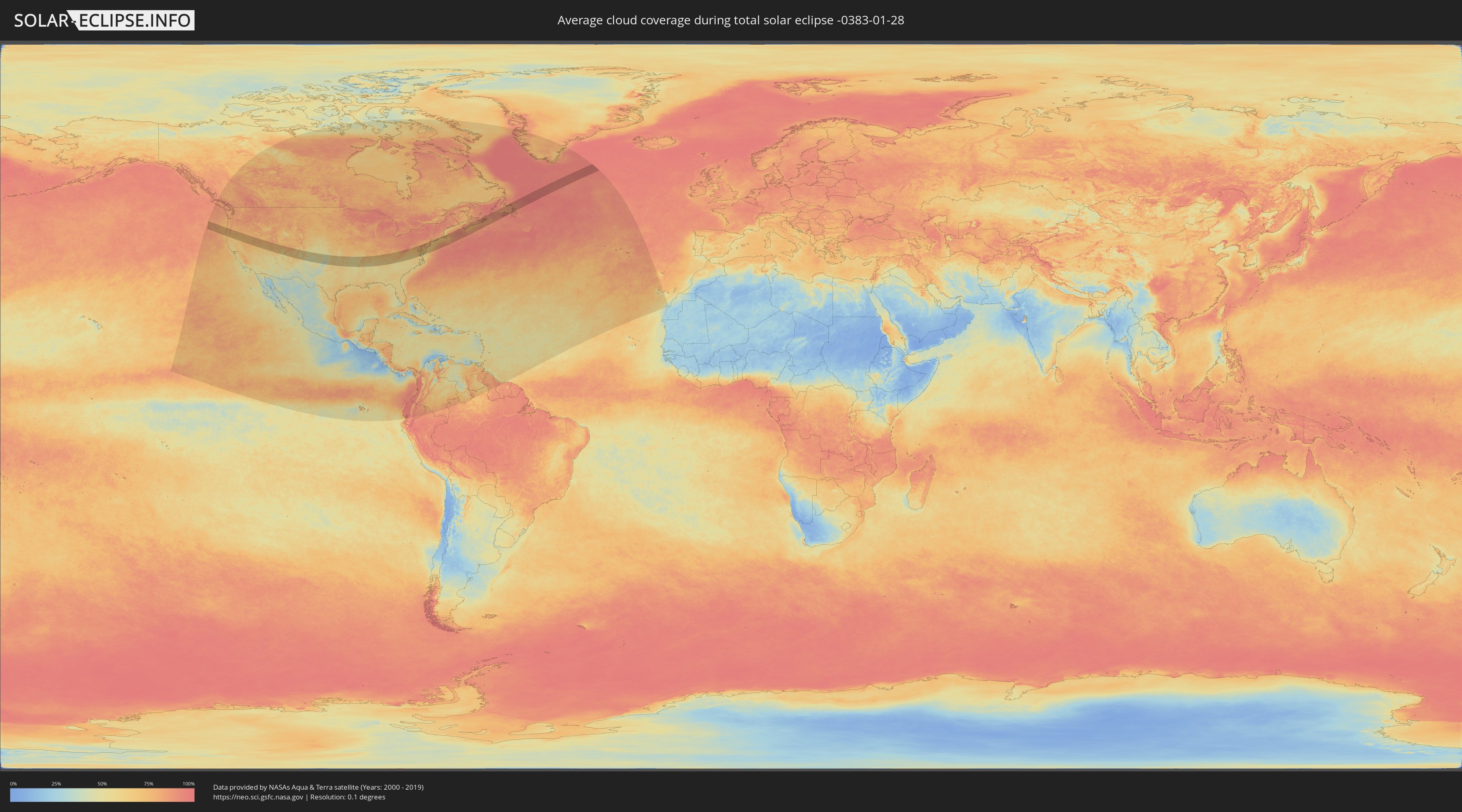
Wie wird das Wetter während der totalen Sonnenfinsternis am 28.01.-0383?
Wo ist der beste Ort, um die totale Sonnenfinsternis vom 28.01.-0383 zu beobachten?
Die folgenden Karten zeigen die durchschnittliche Bewölkung für den Tag, an dem die totale Sonnenfinsternis
stattfindet. Mit Hilfe der Karten lässt sich der Ort entlang des Finsternispfades eingrenzen,
der die besten Aussichen auf einen klaren wolkenfreien Himmel bietet.
Trotzdem muss man immer lokale Gegenenheiten beachten und sollte sich genau über das Wetter an seinem
gewählten Beobachtungsort informieren.
Die Daten stammen von den beiden NASA-Satelliten
AQUA und TERRA
und wurden über einen Zeitraum von 19 Jahren (2000 - 2019) gemittelt.
Detaillierte Länderkarten
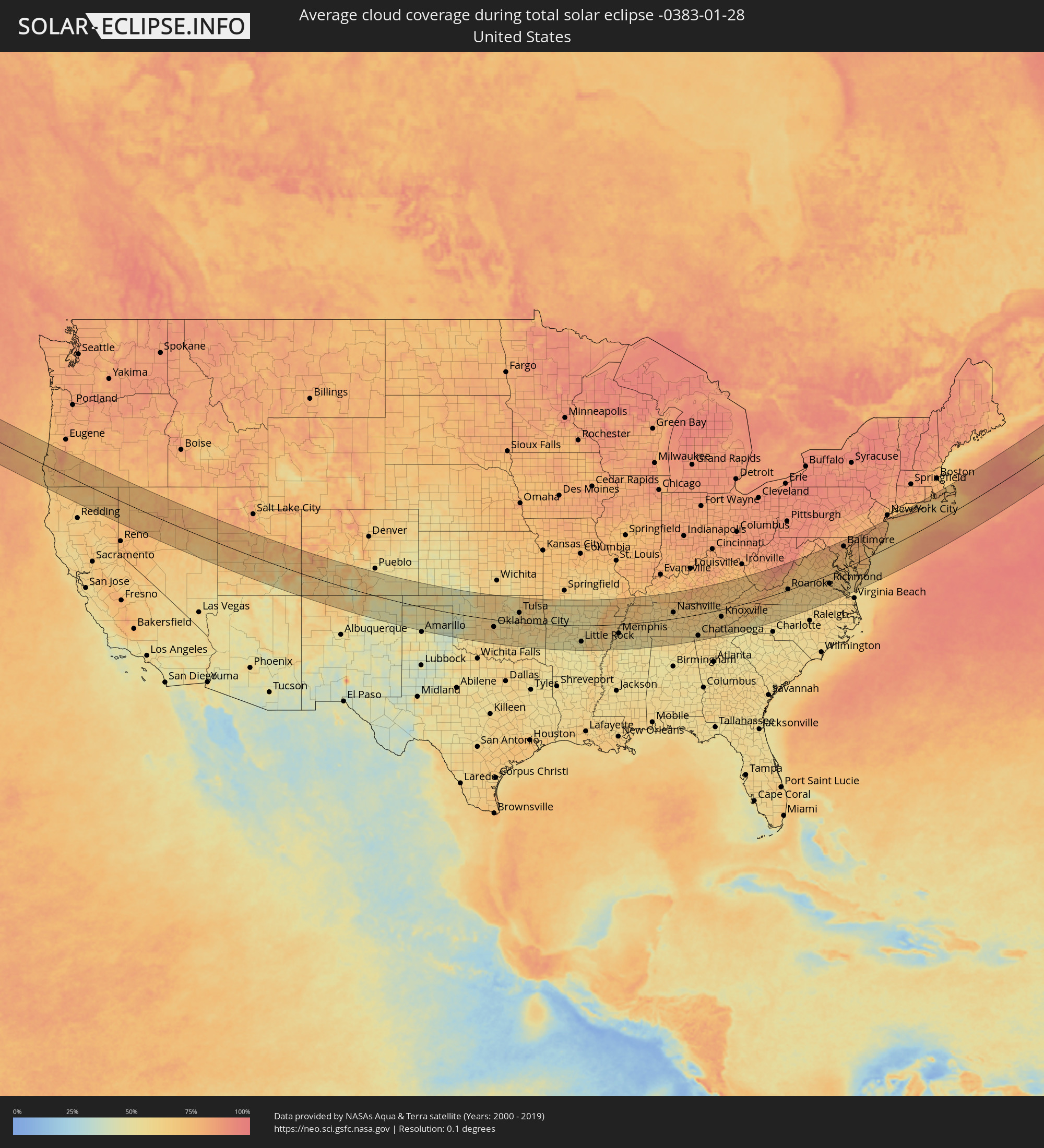 Vereinigte Staaten
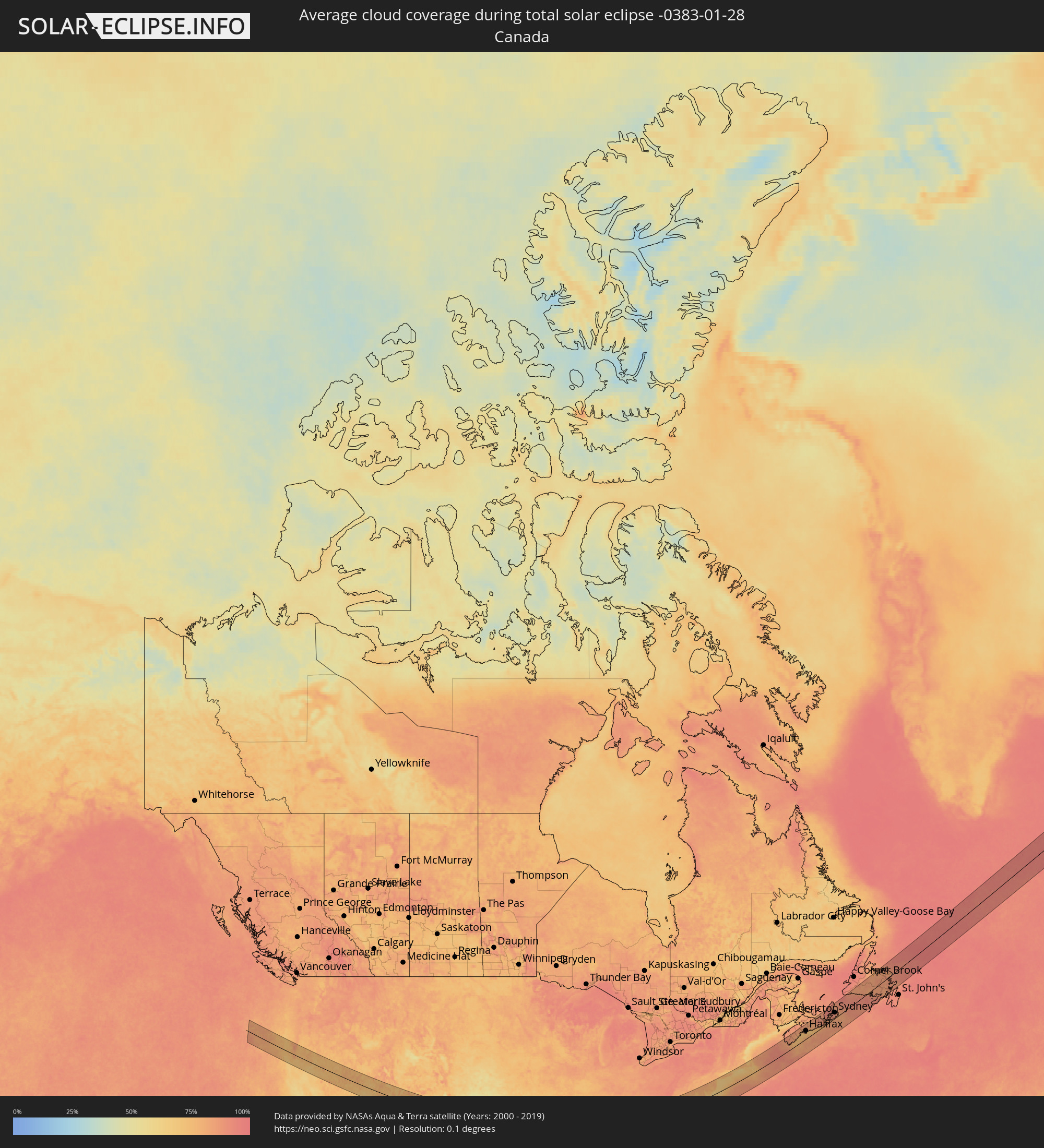 Kanada
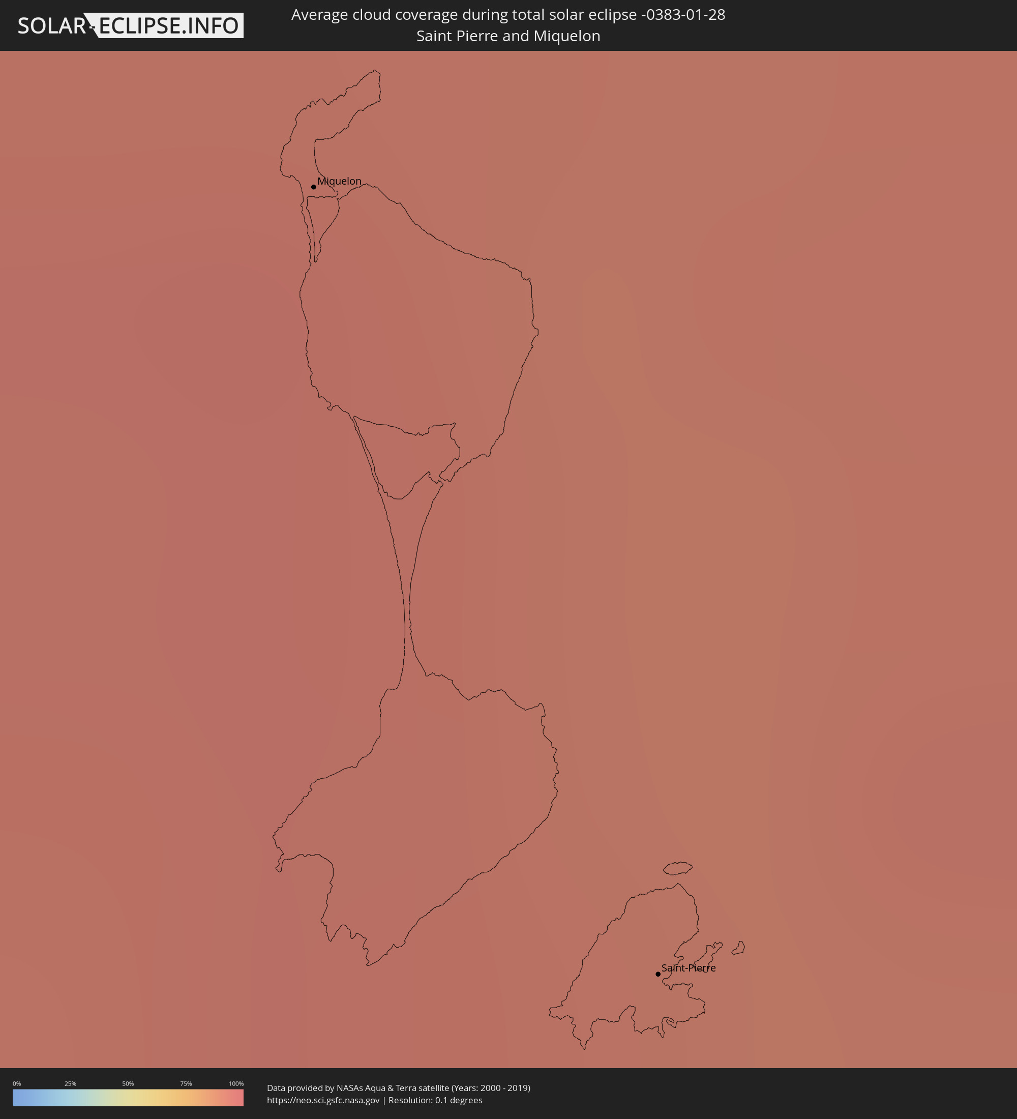 Saint-Pierre und Miquelon
Orte im Finsternispfad
Die nachfolgene Tabelle zeigt Städte und Orte mit mehr als 5.000 Einwohnern, die sich im Finsternispfad befinden. Städte mit mehr als 100.000 Einwohnern sind dick gekennzeichnet. Mit einem Klick auf den Ort öffnet sich eine Detailkarte die die Lage des jeweiligen Ortes zusammen mit dem Verlauf der zentralen Finsternis präsentiert.
| Ort | Typ | Dauer der Verfinsterung | Ortszeit bei maximaler Verfinsterung | Entfernung zur Zentrallinie | Ø Bewölkung |
|
Medford, Oregon
|
total | - | 08:15:31 UTC-08:00 | 10 km | 74% |
|
Enid, Oklahoma
|
total | - | 10:39:41 UTC-06:00 | 59 km | 62% |
|
Oklahoma City, Oklahoma
|
total | - | 10:39:26 UTC-06:00 | 39 km | 63% |
|
Edmond, Oklahoma
|
total | - | 10:39:41 UTC-06:00 | 19 km | 60% |
|
Norman, Oklahoma
|
total | - | 10:39:20 UTC-06:00 | 66 km | 61% |
|
Stillwater, Oklahoma
|
total | - | 10:40:55 UTC-06:00 | 37 km | 59% |
|
Tulsa, Oklahoma
|
total | - | 10:42:57 UTC-06:00 | 52 km | 60% |
|
Broken Arrow, Oklahoma
|
total | - | 10:43:14 UTC-06:00 | 42 km | 64% |
|
Fort Smith, Arkansas
|
total | - | 10:45:19 UTC-06:00 | 23 km | 62% |
|
Fayetteville, Arkansas
|
total | - | 10:46:25 UTC-06:00 | 54 km | 62% |
|
Rogers, Arkansas
|
total | - | 10:46:44 UTC-06:00 | 84 km | 61% |
|
Conway, Arkansas
|
total | - | 10:48:59 UTC-06:00 | 51 km | 55% |
|
Little Rock, Arkansas
|
total | - | 10:49:00 UTC-06:00 | 89 km | 52% |
|
Jonesboro, Arkansas
|
total | - | 10:53:13 UTC-06:00 | 31 km | 73% |
|
Memphis, Tennessee
|
total | - | 10:54:02 UTC-06:00 | 49 km | 58% |
|
Southaven, Mississippi
|
total | - | 10:53:58 UTC-06:00 | 67 km | 58% |
|
Bartlett, Tennessee
|
total | - | 10:54:26 UTC-06:00 | 44 km | 55% |
|
Collierville, Tennessee
|
total | - | 10:54:45 UTC-06:00 | 64 km | 57% |
|
Jackson, Tennessee
|
total | - | 10:57:01 UTC-06:00 | 6 km | 62% |
|
Clarksville, Tennessee
|
total | - | 11:00:49 UTC-06:00 | 80 km | 66% |
|
Decatur, Alabama
|
total | - | 11:00:15 UTC-06:00 | 137 km | 59% |
|
Franklin, Tennessee
|
total | - | 11:01:27 UTC-06:00 | 7 km | 66% |
|
Nashville, Tennessee
|
total | - | 11:01:48 UTC-06:00 | 33 km | 65% |
|
Hendersonville, Tennessee
|
total | - | 11:02:15 UTC-06:00 | 46 km | 66% |
|
Huntsville, Alabama
|
total | - | 11:01:12 UTC-06:00 | 128 km | 60% |
|
Bowling Green, Kentucky
|
total | - | 11:03:07 UTC-06:00 | 118 km | 75% |
|
Murfreesboro, Tennessee
|
total | - | 11:02:26 UTC-06:00 | 8 km | 65% |
|
Chattanooga, Tennessee
|
total | - | 12:04:15 UTC-05:00 | 113 km | 59% |
|
Knoxville, Tennessee
|
total | - | 12:07:55 UTC-05:00 | 38 km | 64% |
|
Kingsport, Tennessee
|
total | - | 12:11:16 UTC-05:00 | 4 km | 72% |
|
Asheville, North Carolina
|
total | - | 12:10:44 UTC-05:00 | 107 km | 58% |
|
Johnson City, Tennessee
|
total | - | 12:11:35 UTC-05:00 | 35 km | 70% |
|
Winston-Salem, North Carolina
|
total | - | 12:16:08 UTC-05:00 | 112 km | 59% |
|
High Point, North Carolina
|
total | - | 12:16:36 UTC-05:00 | 134 km | 58% |
|
Roanoke, Virginia
|
total | - | 12:17:22 UTC-05:00 | 3 km | 67% |
|
Greensboro, North Carolina
|
total | - | 12:17:07 UTC-05:00 | 127 km | 59% |
|
Danville, Virginia
|
total | - | 12:18:14 UTC-05:00 | 85 km | 64% |
|
Lynchburg, Virginia
|
total | - | 12:19:09 UTC-05:00 | 6 km | 64% |
|
Harrisonburg, Virginia
|
total | - | 12:20:11 UTC-05:00 | 94 km | 73% |
|
Charlottesville, Virginia
|
total | - | 12:20:51 UTC-05:00 | 37 km | 66% |
|
Ashburn, Virginia
|
total | - | 12:23:19 UTC-05:00 | 109 km | 79% |
|
Richmond, Virginia
|
total | - | 12:22:50 UTC-05:00 | 45 km | 67% |
|
Centreville, Virginia
|
total | - | 12:23:22 UTC-05:00 | 86 km | 72% |
|
Reston, Virginia
|
total | - | 12:23:35 UTC-05:00 | 96 km | 78% |
|
Dale City, Virginia
|
total | - | 12:23:32 UTC-05:00 | 61 km | 73% |
|
Germantown, Maryland
|
total | - | 12:23:48 UTC-05:00 | 115 km | 79% |
|
Aspen Hill, Maryland
|
total | - | 12:24:11 UTC-05:00 | 98 km | 76% |
|
Washington, D.C., Washington, D.C.
|
total | - | 12:24:12 UTC-05:00 | 78 km | 75% |
|
Waldorf, Maryland
|
total | - | 12:24:19 UTC-05:00 | 47 km | 76% |
|
Columbia, Maryland
|
total | - | 12:24:44 UTC-05:00 | 106 km | 80% |
|
Bowie, Maryland
|
total | - | 12:24:52 UTC-05:00 | 72 km | 76% |
|
Severn, Maryland
|
total | - | 12:24:59 UTC-05:00 | 91 km | 77% |
|
Baltimore, Maryland
|
total | - | 12:25:13 UTC-05:00 | 103 km | 78% |
|
Newport News, Virginia
|
total | - | 12:24:48 UTC-05:00 | 127 km | 61% |
|
South Bel Air, Maryland
|
total | - | 12:25:51 UTC-05:00 | 118 km | 80% |
|
Wilmington, Delaware
|
total | - | 12:27:32 UTC-05:00 | 110 km | 80% |
|
Philadelphia, Pennsylvania
|
total | - | 12:28:22 UTC-05:00 | 116 km | 82% |
|
Vineland, New Jersey
|
total | - | 12:28:32 UTC-05:00 | 65 km | 77% |
|
Jackson, New Jersey
|
total | - | 12:28:56 UTC-05:00 | 87 km | 78% |
|
Trenton, New Jersey
|
total | - | 12:29:16 UTC-05:00 | 127 km | 79% |
|
Lakewood, New Jersey
|
total | - | 12:30:18 UTC-05:00 | 94 km | 80% |
|
Toms River, New Jersey
|
total | - | 12:30:19 UTC-05:00 | 79 km | 80% |
|
Levittown, New York
|
total | - | 12:31:49 UTC-05:00 | 128 km | 74% |
|
Brentwood, New York
|
total | - | 12:32:21 UTC-05:00 | 123 km | 79% |
|
Fall River, Massachusetts
|
total | - | 12:36:29 UTC-05:00 | 125 km | 77% |
|
New Bedford, Massachusetts
|
total | - | 12:36:53 UTC-05:00 | 110 km | 75% |
|
Barnstable, Massachusetts
|
total | - | 12:38:05 UTC-05:00 | 89 km | 76% |
|
Yarmouth, Nova Scotia
|
total | - | 13:30:58 UTC-04:14 | 104 km | 86% |
|
Bridgewater, Nova Scotia
|
total | - | 13:33:30 UTC-04:14 | 81 km | 81% |
|
Lower Sacvkille, Nova Scotia
|
total | - | 13:34:45 UTC-04:14 | 79 km | 84% |
|
Dartmouth, Nova Scotia
|
total | - | 13:34:57 UTC-04:14 | 65 km | 82% |
|
Halifax, Nova Scotia
|
total | - | 13:34:58 UTC-04:14 | 62 km | 80% |
|
Cole Harbour, Nova Scotia
|
total | - | 13:35:07 UTC-04:14 | 60 km | 82% |
|
Truro, Nova Scotia
|
total | - | 13:35:14 UTC-04:14 | 113 km | 82% |
|
New Glasgow, Nova Scotia
|
total | - | 13:36:07 UTC-04:14 | 105 km | 86% |
|
Antigonish, Nova Scotia
|
total | - | 13:37:06 UTC-04:14 | 78 km | 87% |
|
Princeville, Nova Scotia
|
total | - | 13:38:06 UTC-04:14 | 59 km | 90% |
|
Sydney Mines, Nova Scotia
|
total | - | 13:39:31 UTC-04:14 | 51 km | 90% |
|
Sydney, Nova Scotia
|
total | - | 13:39:36 UTC-04:14 | 41 km | 90% |
|
Glace Bay, Nova Scotia
|
total | - | 13:39:54 UTC-04:14 | 36 km | 86% |
|
Miquelon, Miquelon-Langlade
|
total | - | 14:14:08 UTC-03:44 | 48 km | 94% |
|
Saint-Pierre, Saint-Pierre
|
total | - | 14:14:34 UTC-03:44 | 86 km | 92% |
|
Grand Falls-Windsor, Newfoundland and Labrador
|
total | - | 14:27:47 UTC-03:30 | 81 km | 84% |