Totale Sonnenfinsternis vom 27.01.-0410
| Wochentag: | Freitag |
| Maximale Dauer der Verfinsterung: | 04m44s |
| Maximale Breite des Finsternispfades: | 203 km |
| Saroszyklus: | 63 |
| Bedeckungsgrad: | 100% |
| Magnitude: | 1.0525 |
| Gamma: | 0.5294 |
Wo kann man die Sonnenfinsternis vom 27.01.-0410 sehen?
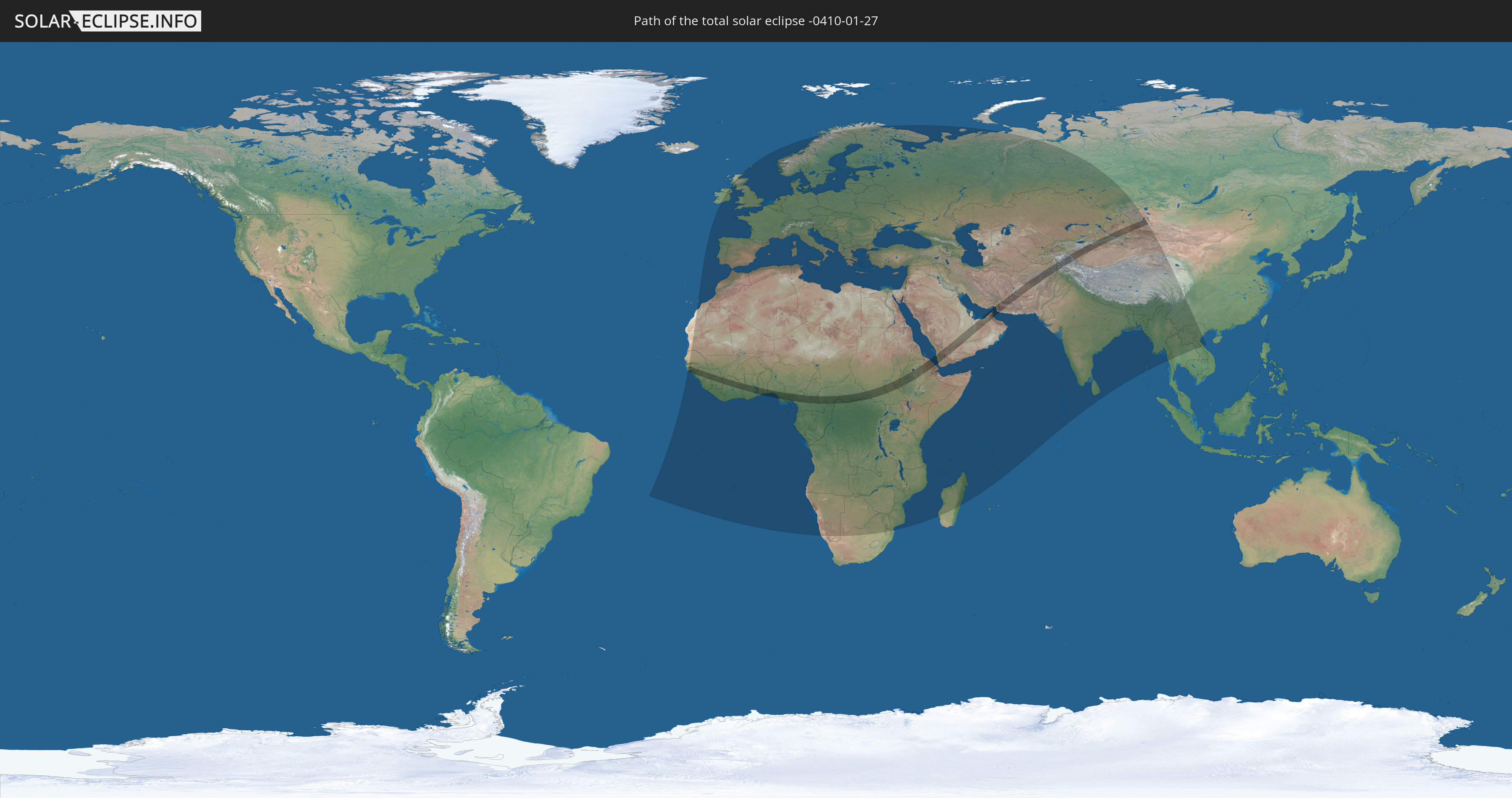
Die Sonnenfinsternis am 27.01.-0410 kann man in 140 Ländern als partielle Sonnenfinsternis beobachten.
Der Finsternispfad verläuft durch 28 Länder. Nur in diesen Ländern ist sie als totale Sonnenfinsternis zu sehen.
In den folgenden Ländern ist die Sonnenfinsternis total zu sehen
 Senegal
 Guinea-Bissau
 Guinea
 Sierra Leone
 Elfenbeinküste
 Ghana
Ghana
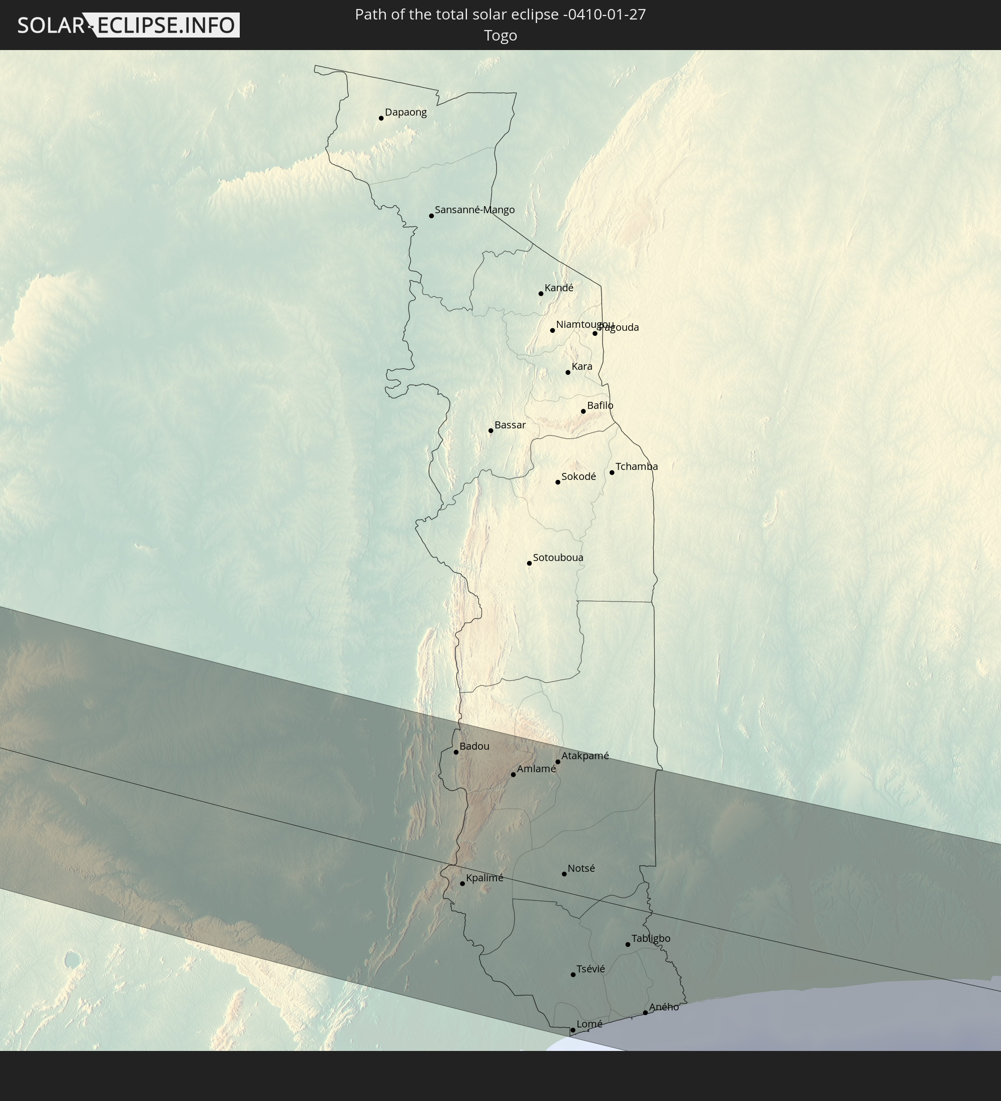 Togo
Togo
 Benin
Benin
 Nigeria
 Kamerun
 Demokratische Republik Kongo
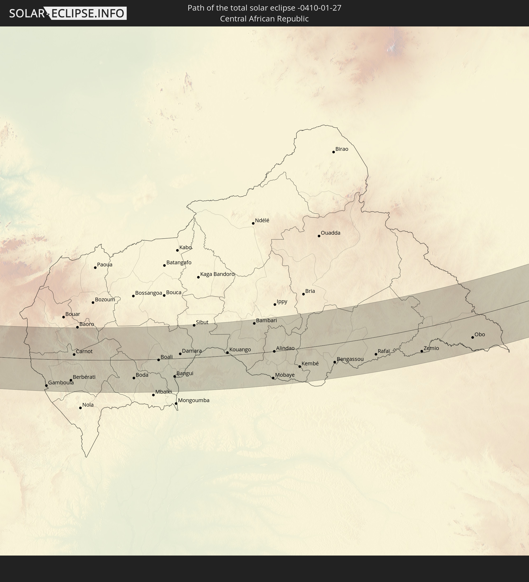 Zentralafrikanische Republik
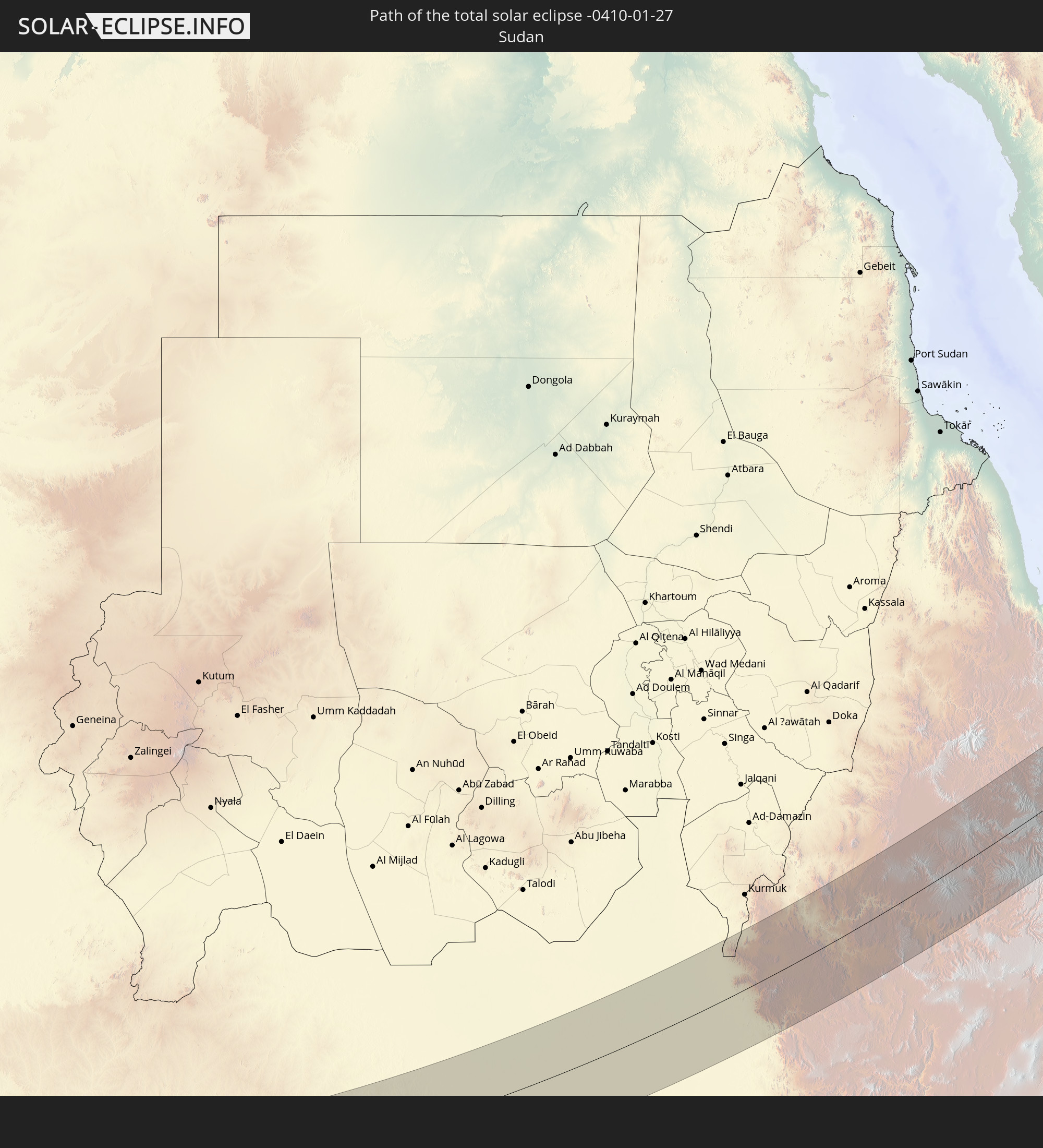 Sudan
Sudan
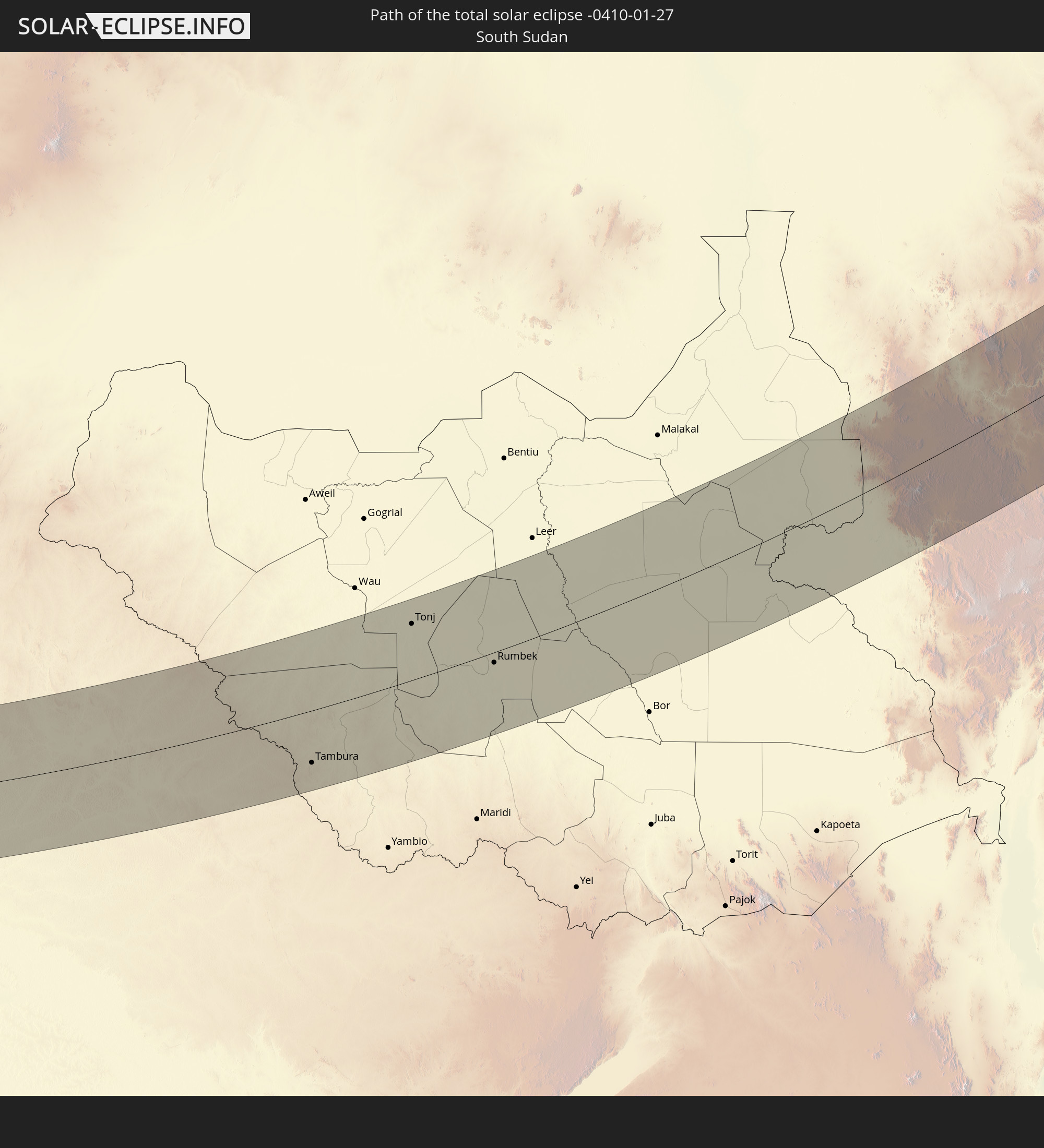 Südsudan
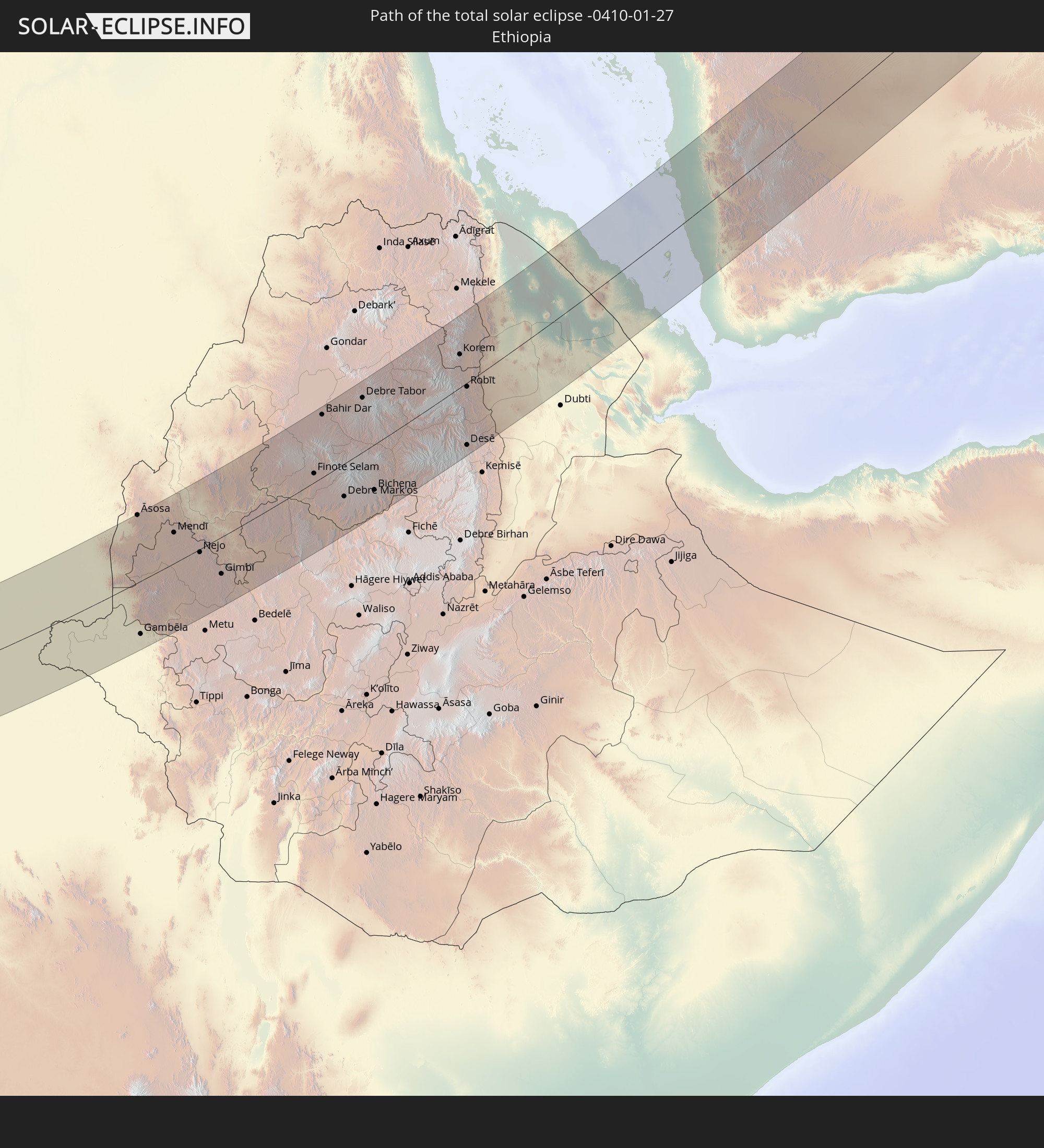 Äthiopien
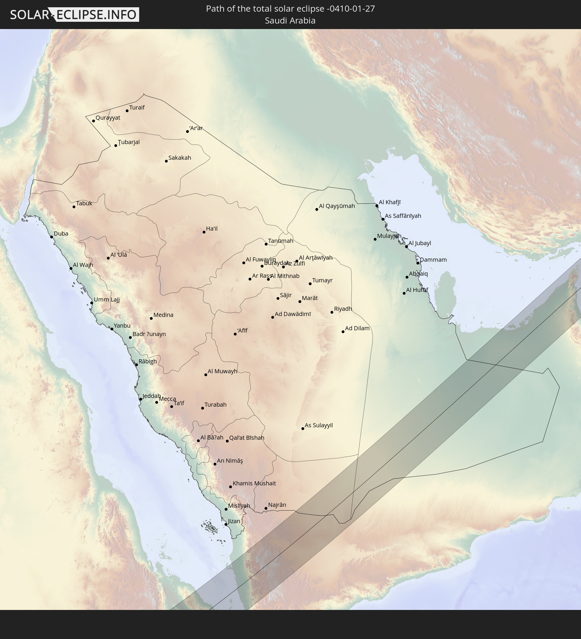 Saudi-Arabien
 Eritrea
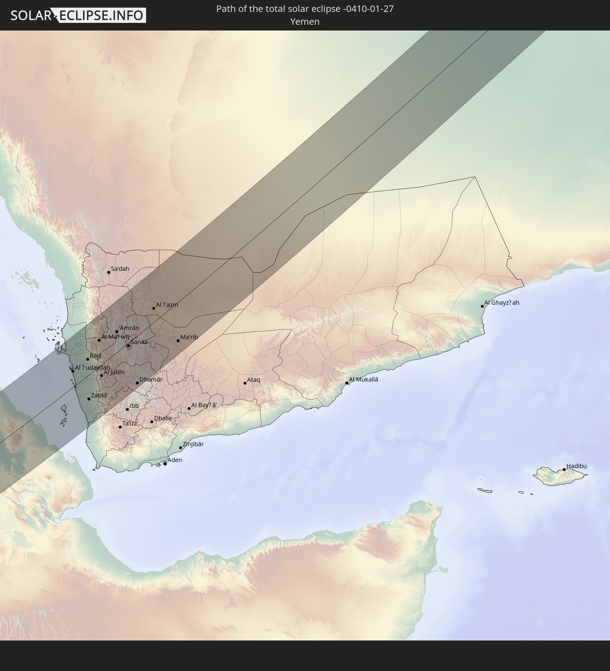 Jemen
Jemen
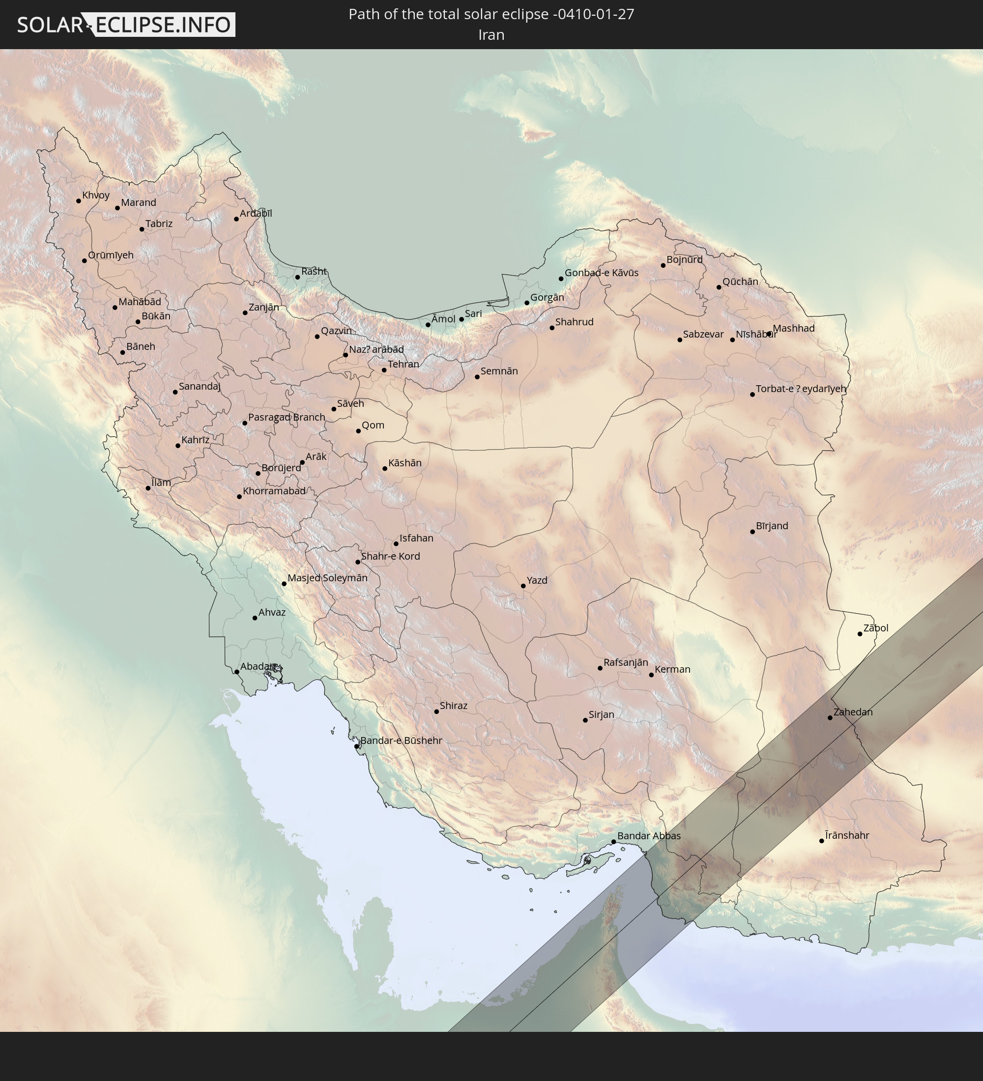 Iran
Iran
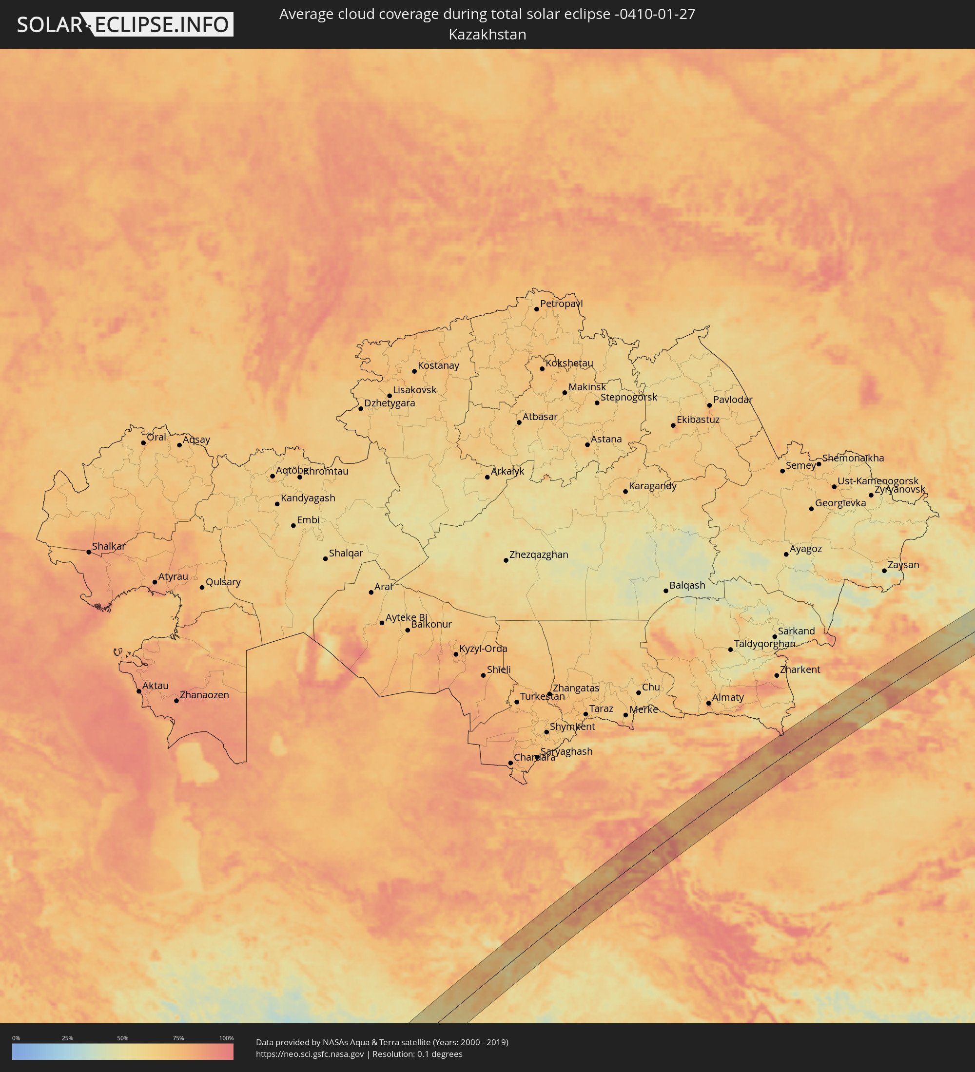
 Kasachstan
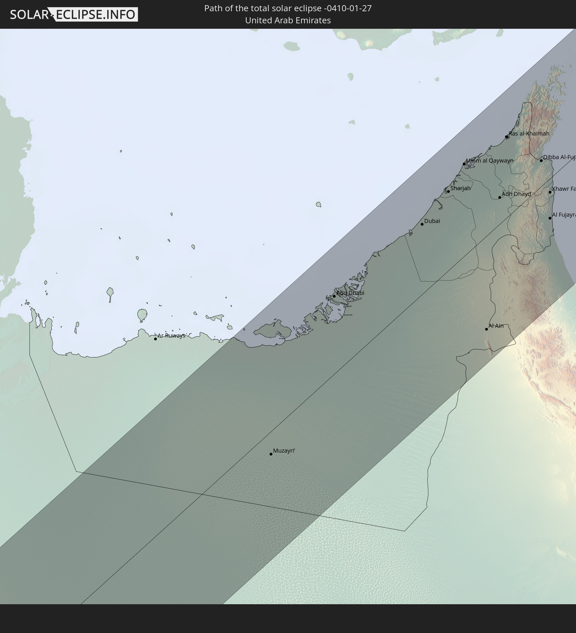 Vereinigte Arabische Emirate
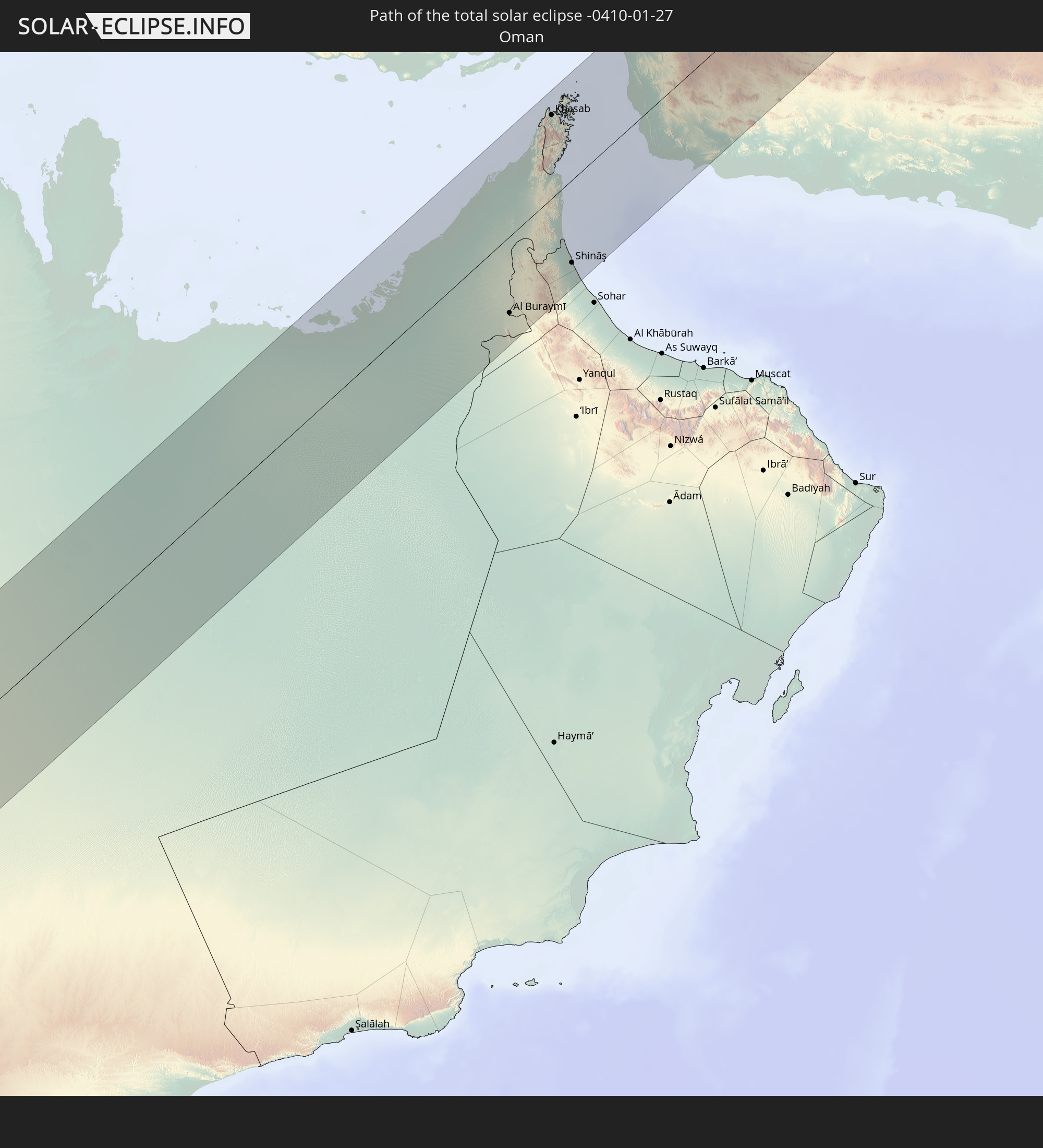 Oman
Oman
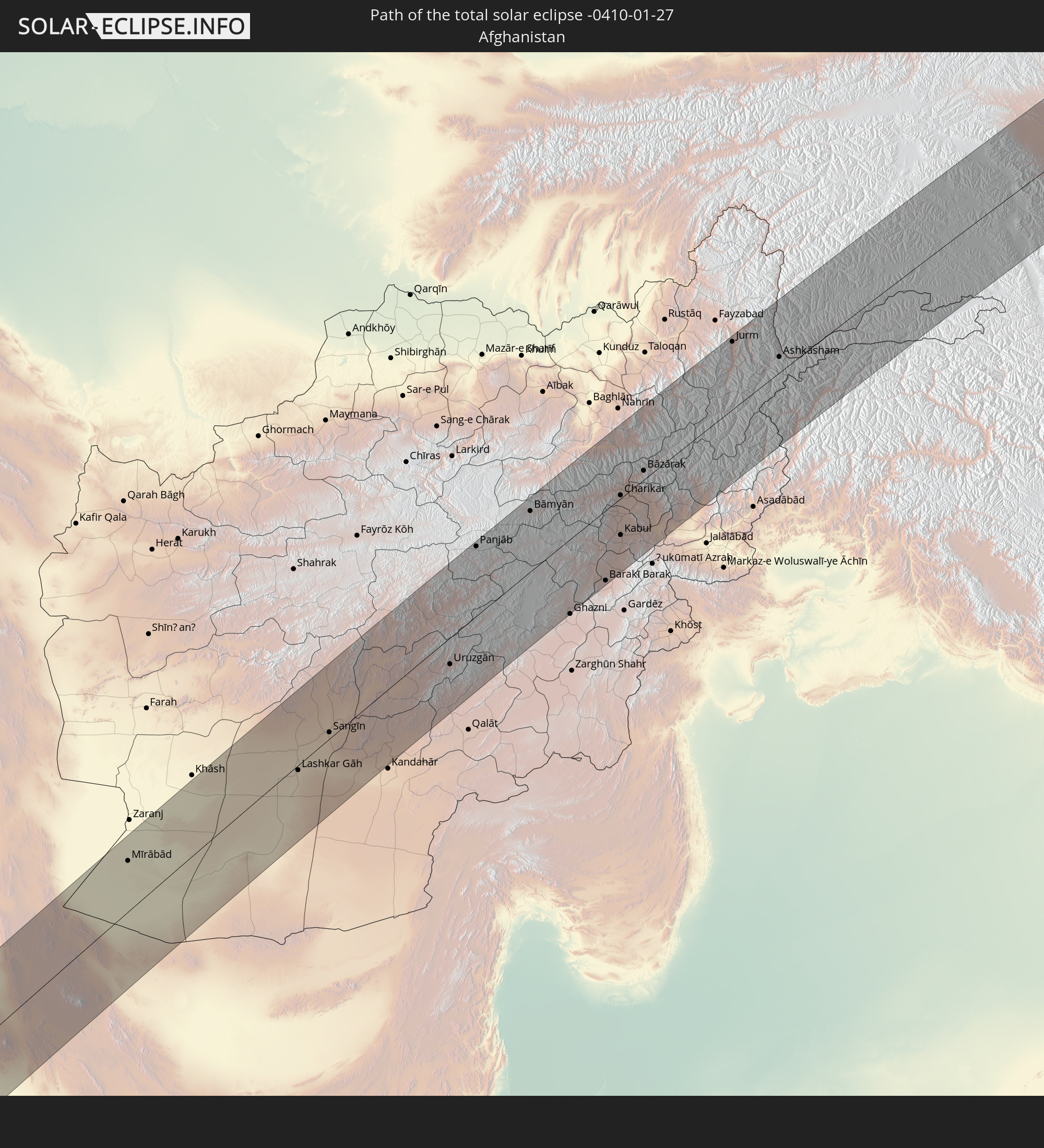 Afghanistan
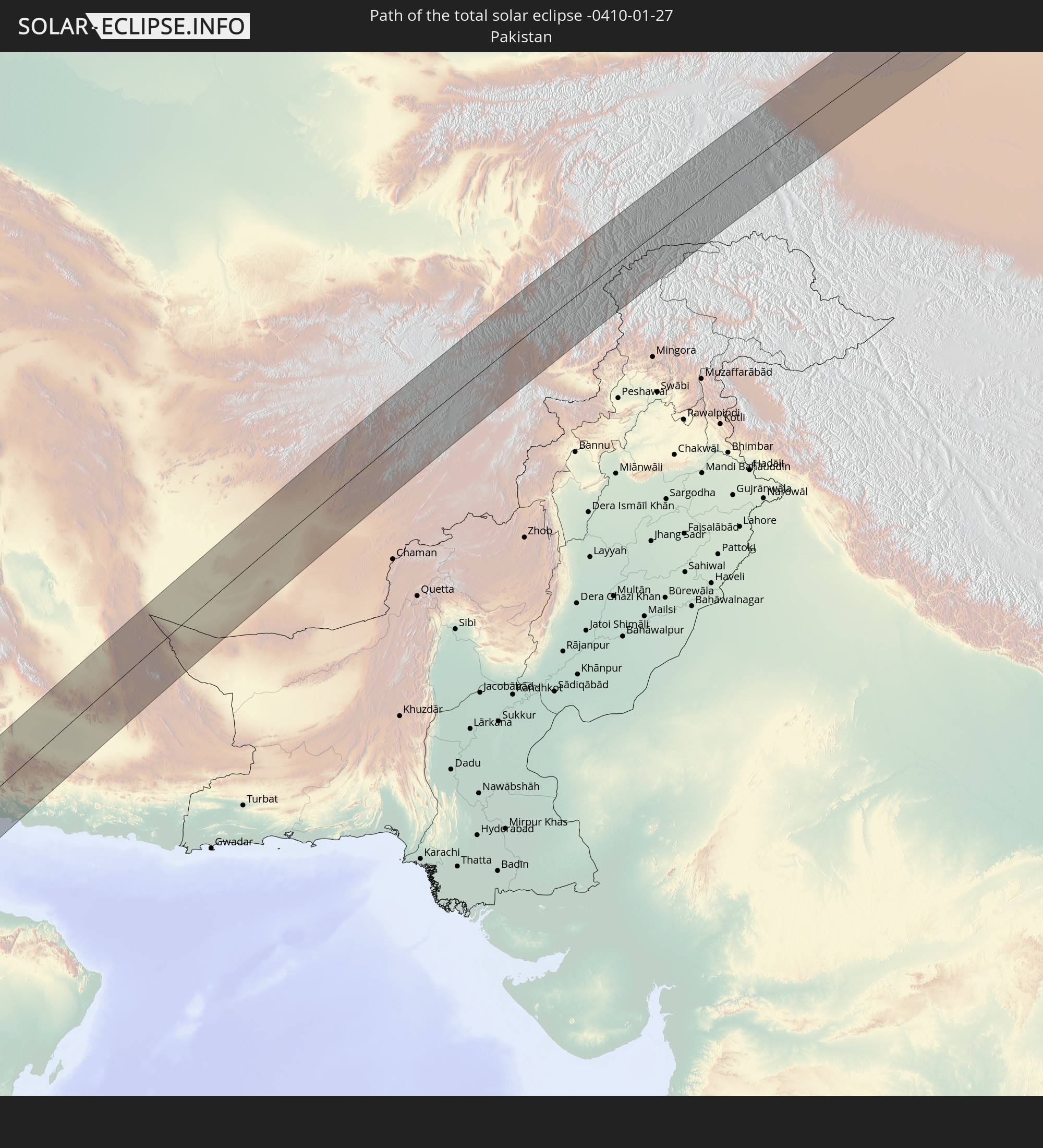 Pakistan
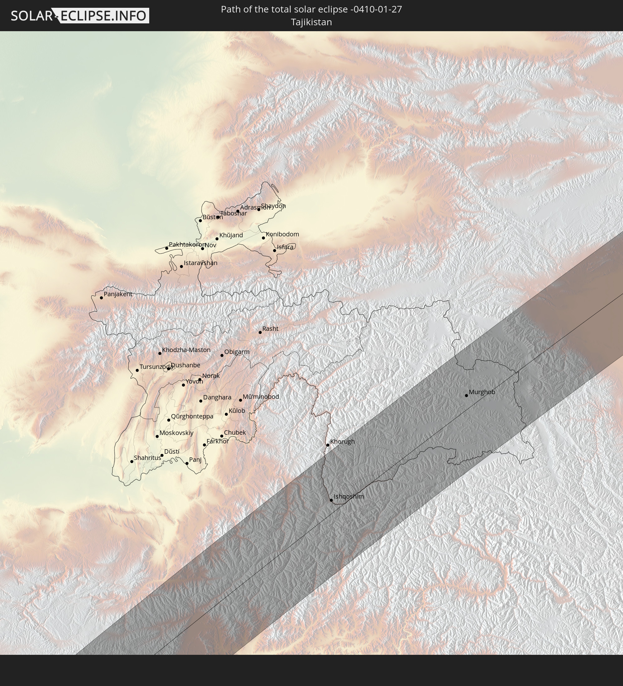 Tadschikistan
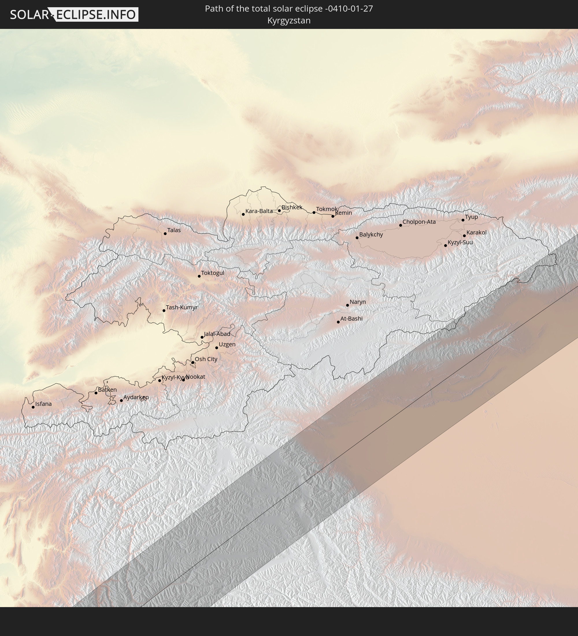 Kirgisistan
 Volksrepublik China
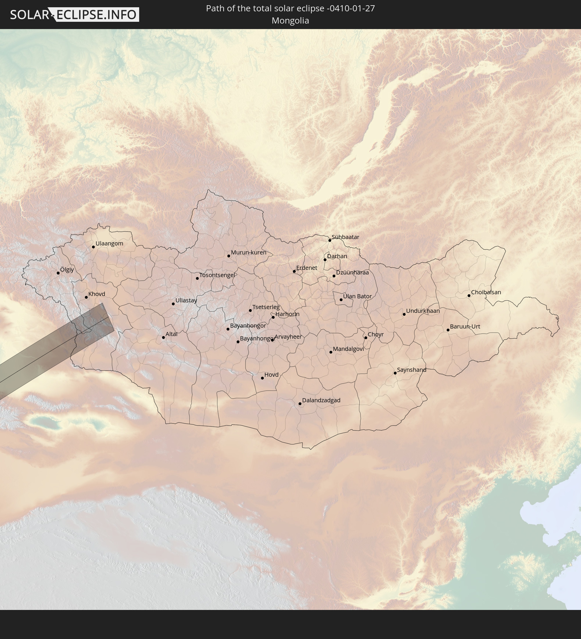 Mongolei
In den folgenden Ländern ist die Sonnenfinsternis partiell zu sehen
 Russland
 Portugal
 Spanien
 Senegal
 Mauretanien
 Gambia
 Guinea-Bissau
 Guinea
 St. Helena
 Sierra Leone
 Marokko
 Mali
Mali
 Liberia
 Irland
 Algerien
 Vereinigtes Königreich
 Elfenbeinküste
 Burkina Faso
 Gibraltar
 Frankreich
 Isle of Man
 Ghana
Ghana
 Guernsey
 Jersey
 Togo
Togo
 Niger
Niger
 Benin
Benin
 Andorra
 Belgien
 Nigeria
 Niederlande
 Norwegen
 Äquatorialguinea
 Luxemburg
 Deutschland
 Schweiz
 São Tomé und Príncipe
 Italien
 Monaco
 Tunesien
 Dänemark
 Kamerun
 Gabun
Gabun
 Libyen
 Liechtenstein
 Österreich
 Schweden
 Republik Kongo
 Angola
 Namibia
 Tschechien
 Demokratische Republik Kongo
 San Marino
 Vatikanstadt
 Slowenien
 Tschad
 Kroatien
 Polen
Polen
 Malta
Malta
 Zentralafrikanische Republik
 Bosnien und Herzegowina
 Ungarn
 Südafrika
 Slowakei
 Montenegro
 Serbien
 Albanien
 Åland Islands
 Griechenland
 Botswana
 Rumänien
 Mazedonien
 Finnland
 Litauen
 Lettland
 Estland
 Sudan
Sudan
 Sambia
 Ukraine
 Bulgarien
 Weißrussland
 Ägypten
 Simbabwe
 Türkei
 Moldawien
 Ruanda
 Burundi
 Tansania
 Uganda
 Mosambik
 Swasiland
 Republik Zypern
 Malawi
 Äthiopien
 Kenia
Kenia
 Staat Palästina
 Israel
 Saudi-Arabien
 Jordanien
 Libanon
 Syrien
 Eritrea
 Irak
Irak
 Georgien
 Französische Süd- und Antarktisgebiete
 Somalia
 Dschibuti
 Jemen
Jemen
 Madagaskar
 Komoren
 Armenien
 Iran
Iran
 Aserbaidschan
 Mayotte
 Seychellen
 Kasachstan
 Kuwait
 Bahrain
 Katar
Katar
 Vereinigte Arabische Emirate
 Oman
Oman
 Turkmenistan
 Usbekistan
 Mauritius
 Afghanistan
 Pakistan
 Tadschikistan
 Indien
 Kirgisistan
 Malediven
 Volksrepublik China
 Sri Lanka
 Nepal
Nepal
 Mongolei
 Bangladesch
 Bhutan
 Myanmar
 Thailand
 Laos
Laos
 Vietnam
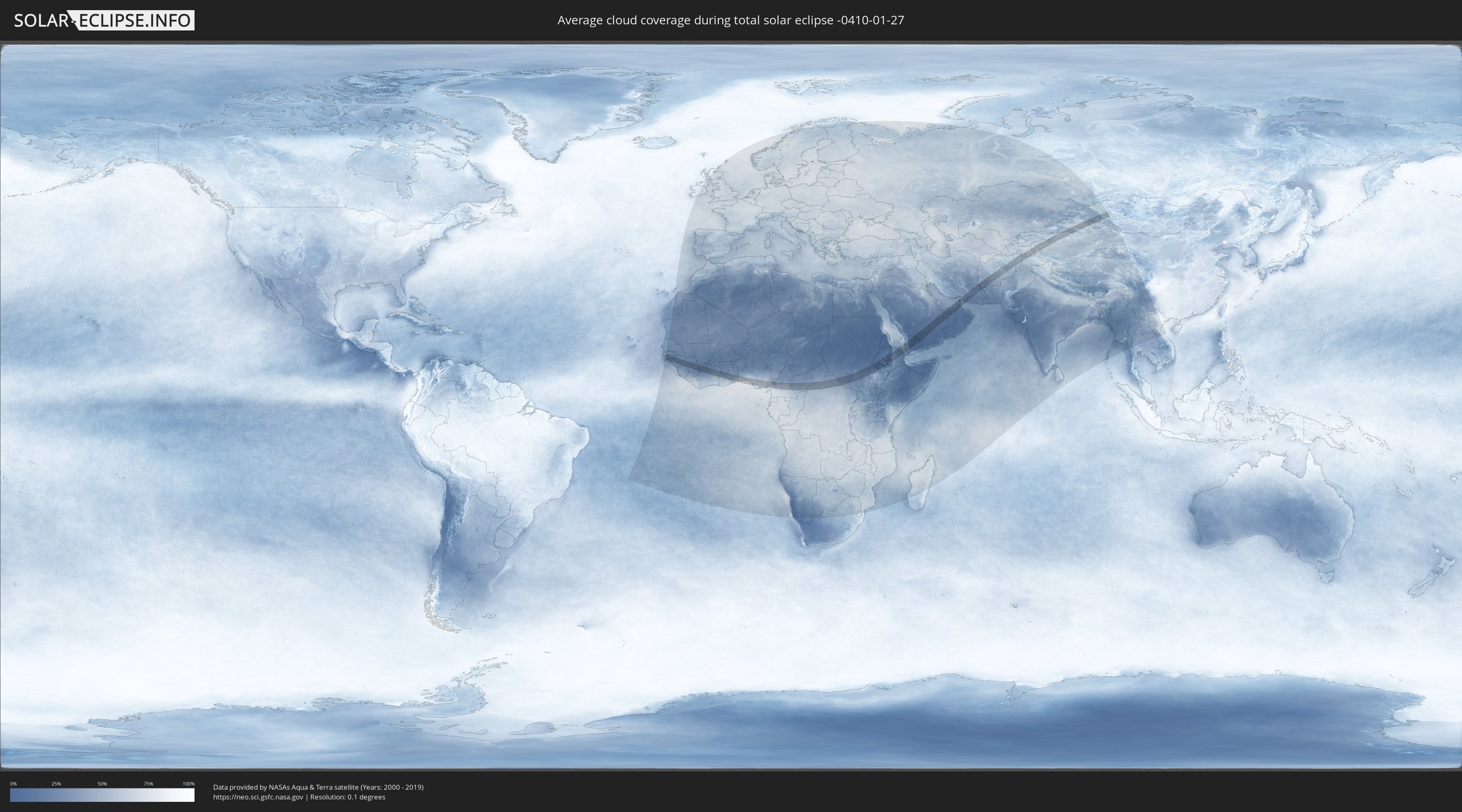
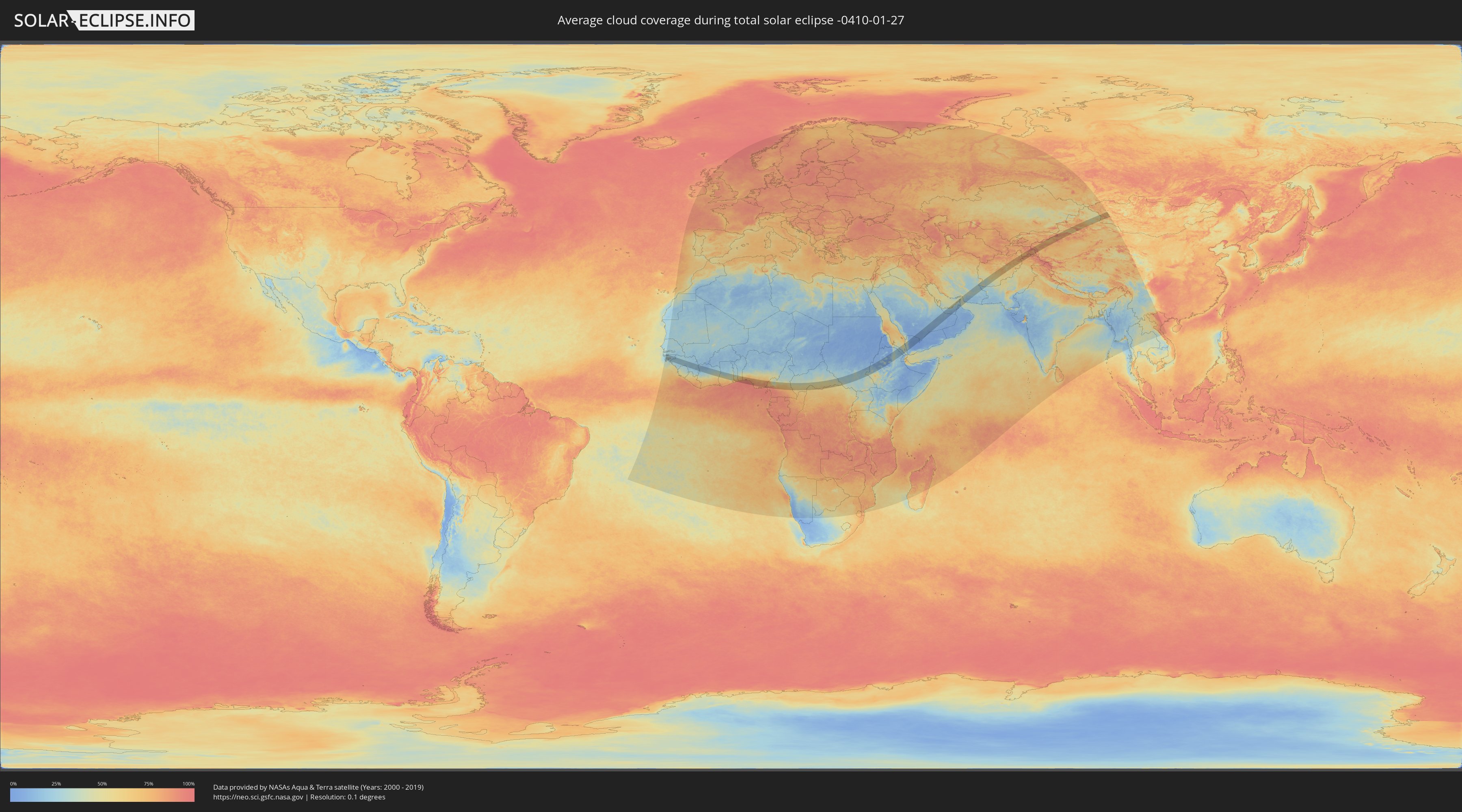
Wie wird das Wetter während der totalen Sonnenfinsternis am 27.01.-0410?
Wo ist der beste Ort, um die totale Sonnenfinsternis vom 27.01.-0410 zu beobachten?
Die folgenden Karten zeigen die durchschnittliche Bewölkung für den Tag, an dem die totale Sonnenfinsternis
stattfindet. Mit Hilfe der Karten lässt sich der Ort entlang des Finsternispfades eingrenzen,
der die besten Aussichen auf einen klaren wolkenfreien Himmel bietet.
Trotzdem muss man immer lokale Gegenenheiten beachten und sollte sich genau über das Wetter an seinem
gewählten Beobachtungsort informieren.
Die Daten stammen von den beiden NASA-Satelliten
AQUA und TERRA
und wurden über einen Zeitraum von 19 Jahren (2000 - 2019) gemittelt.
Detaillierte Länderkarten
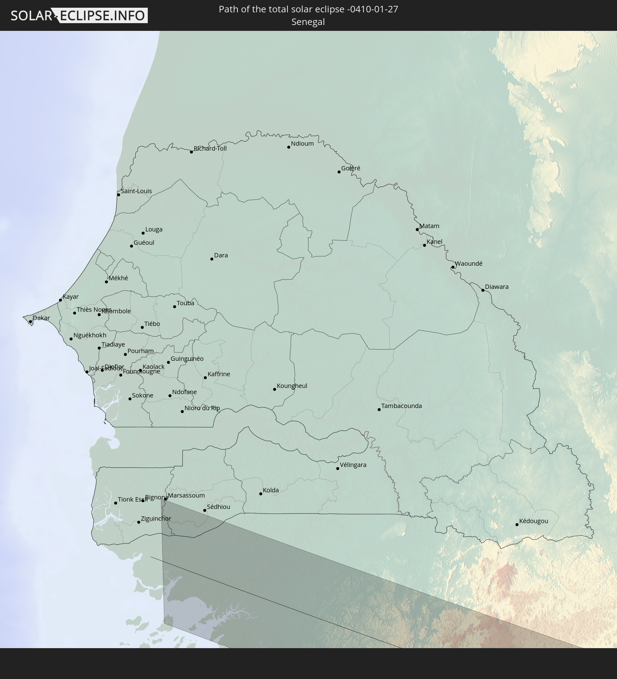
 Senegal
 Guinea-Bissau
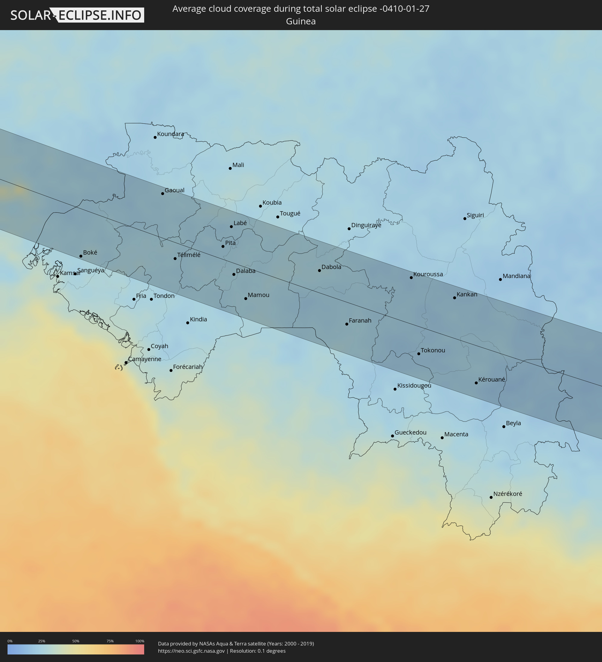 Guinea
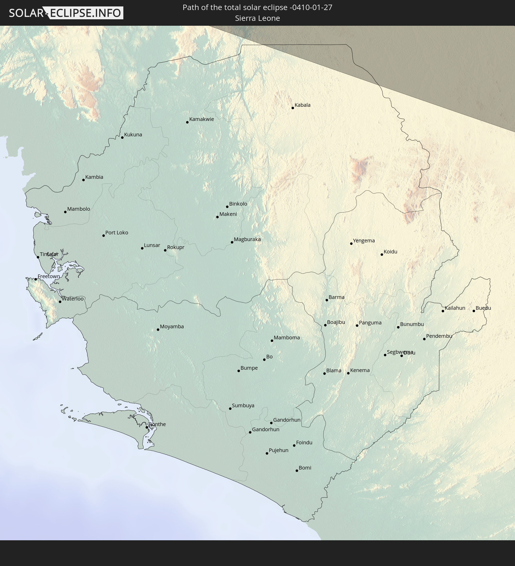
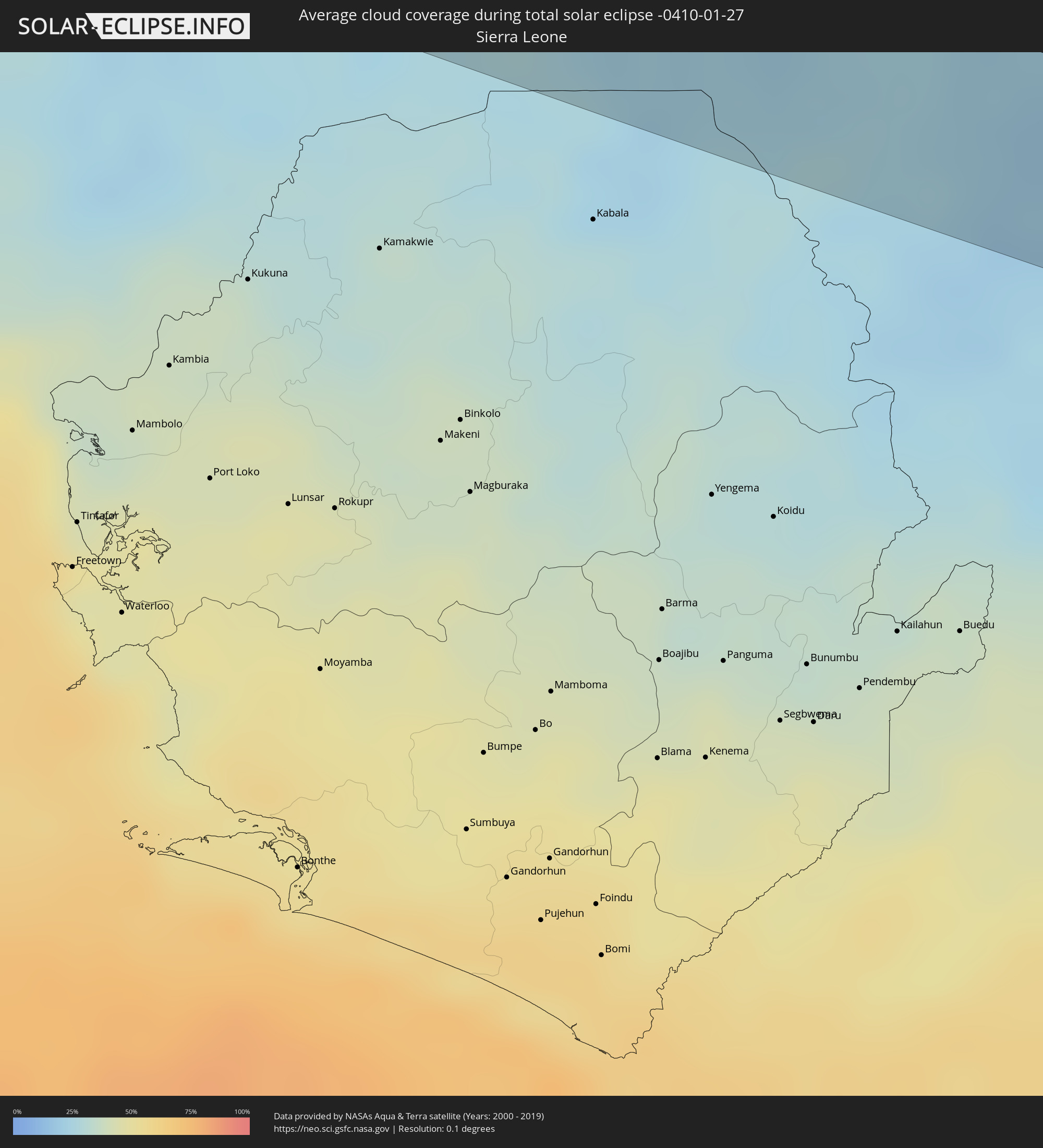 Sierra Leone
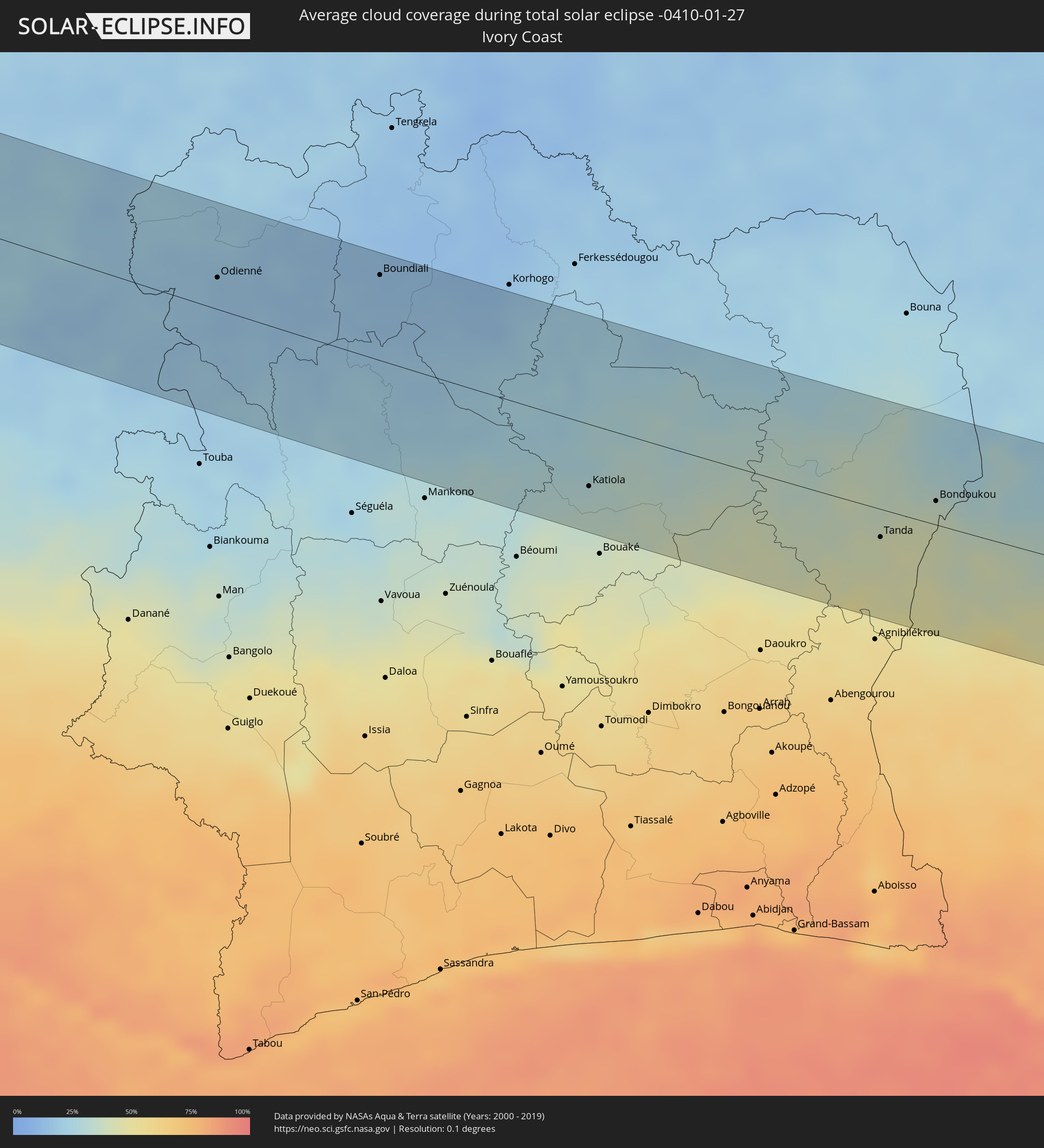 Elfenbeinküste
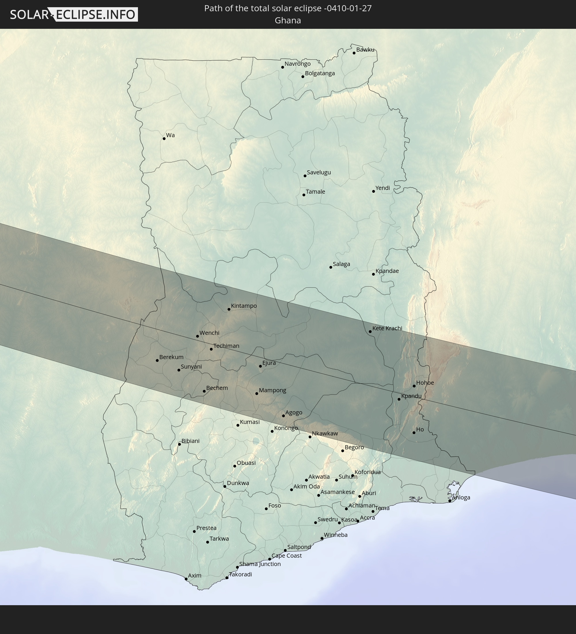
 Ghana
Ghana
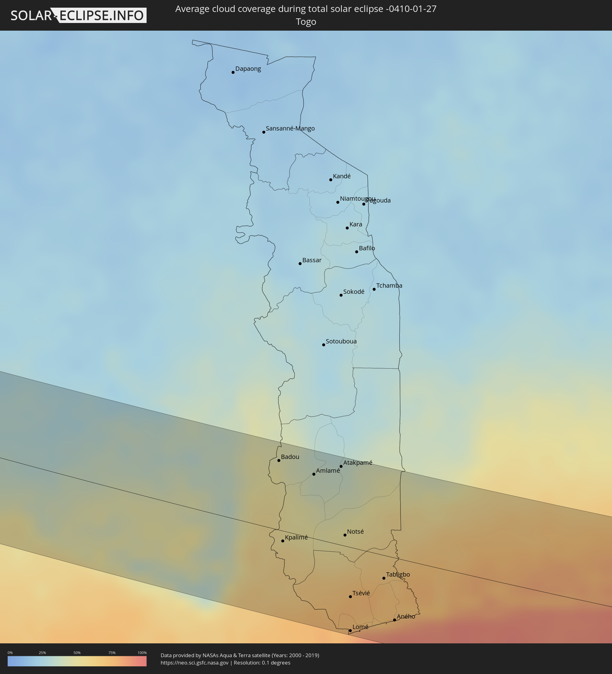 Togo
Togo
 Benin
Benin
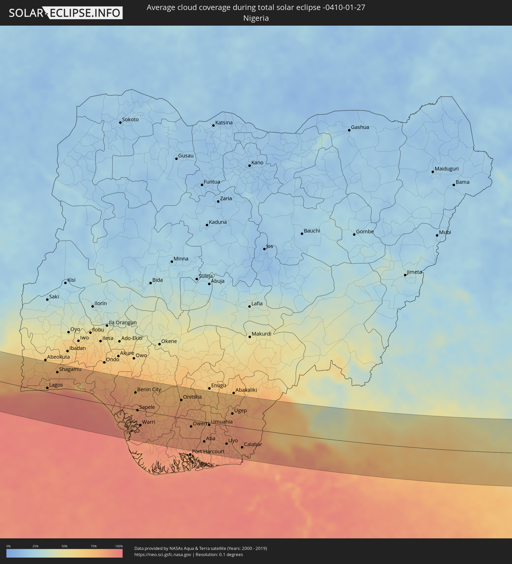 Nigeria
 Kamerun
 Demokratische Republik Kongo
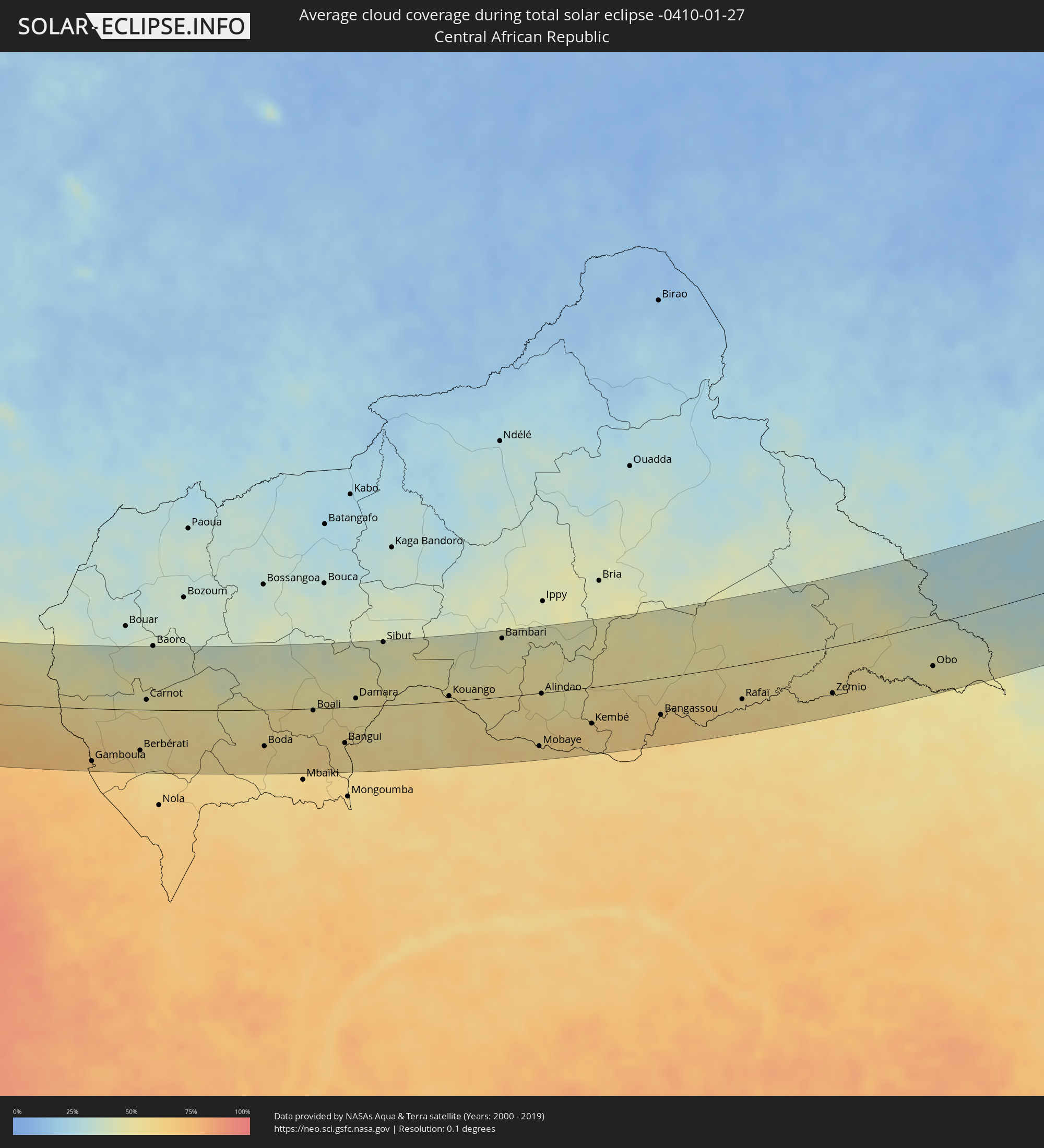 Zentralafrikanische Republik
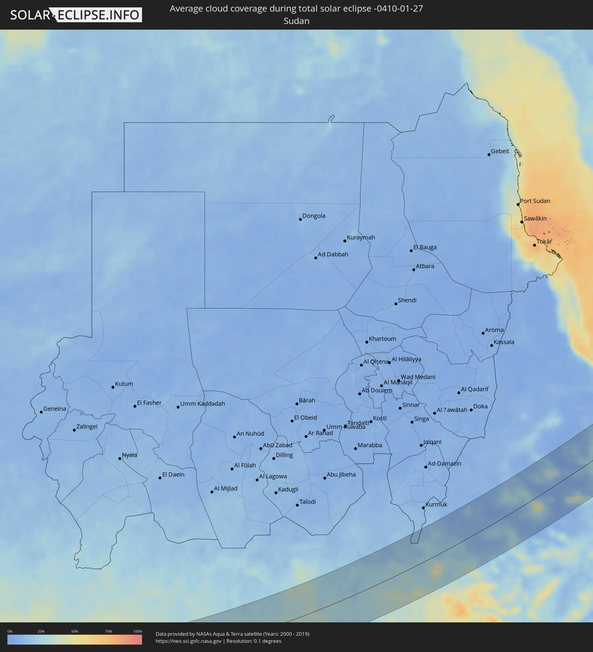 Sudan
Sudan
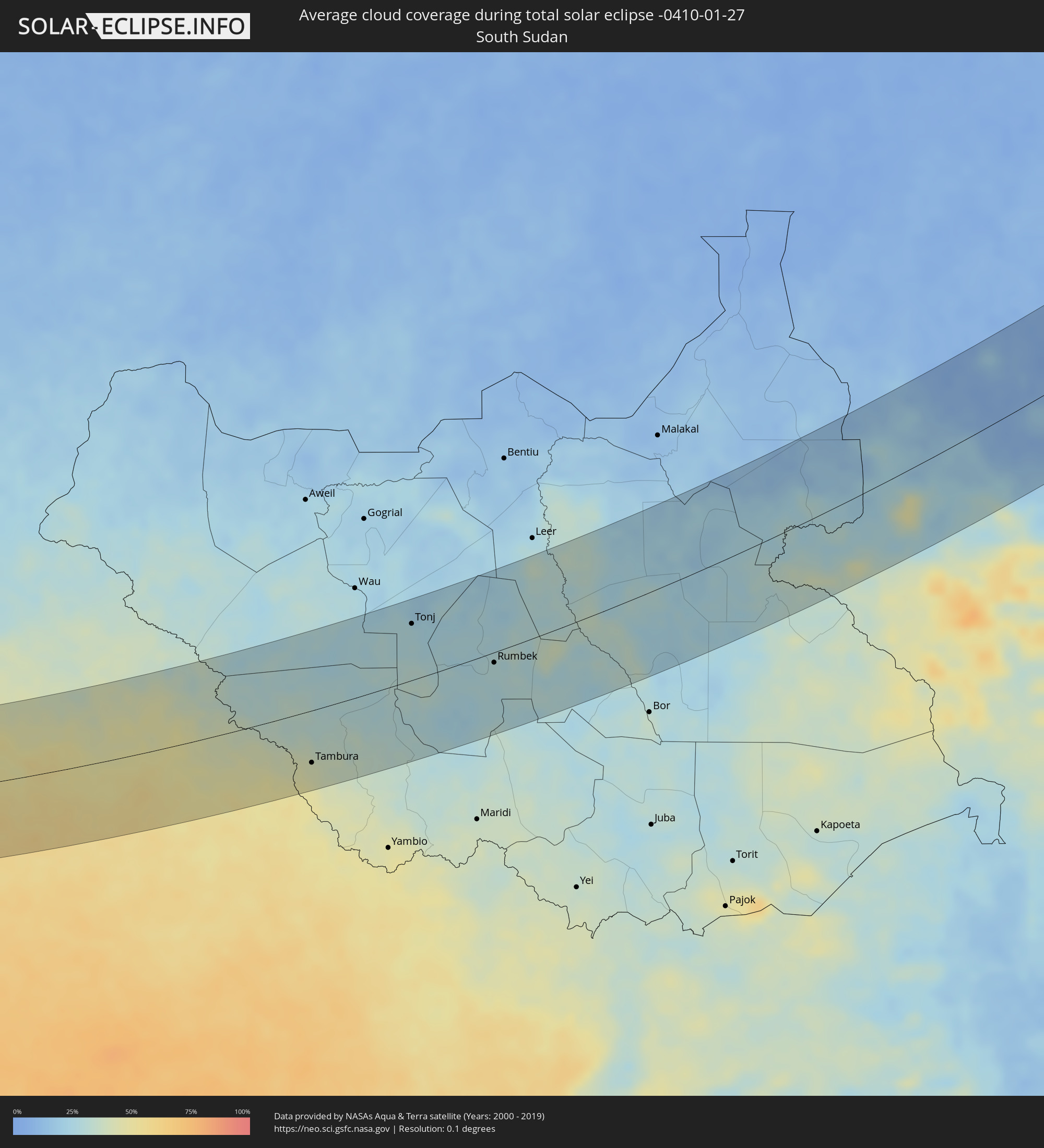 Südsudan
 Äthiopien
 Saudi-Arabien
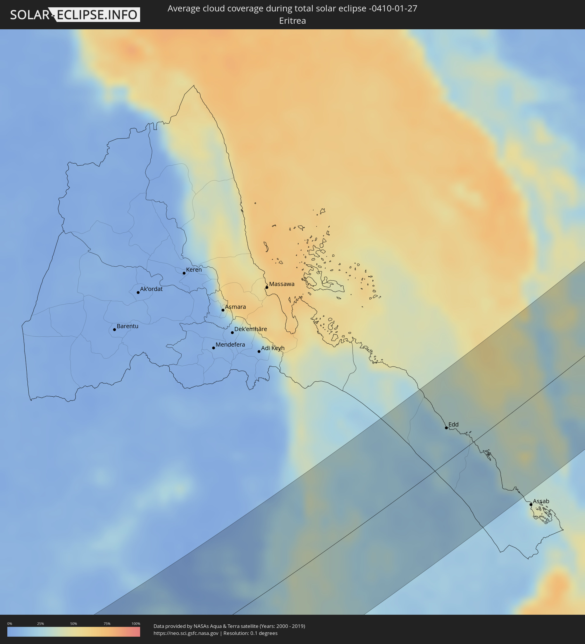 Eritrea
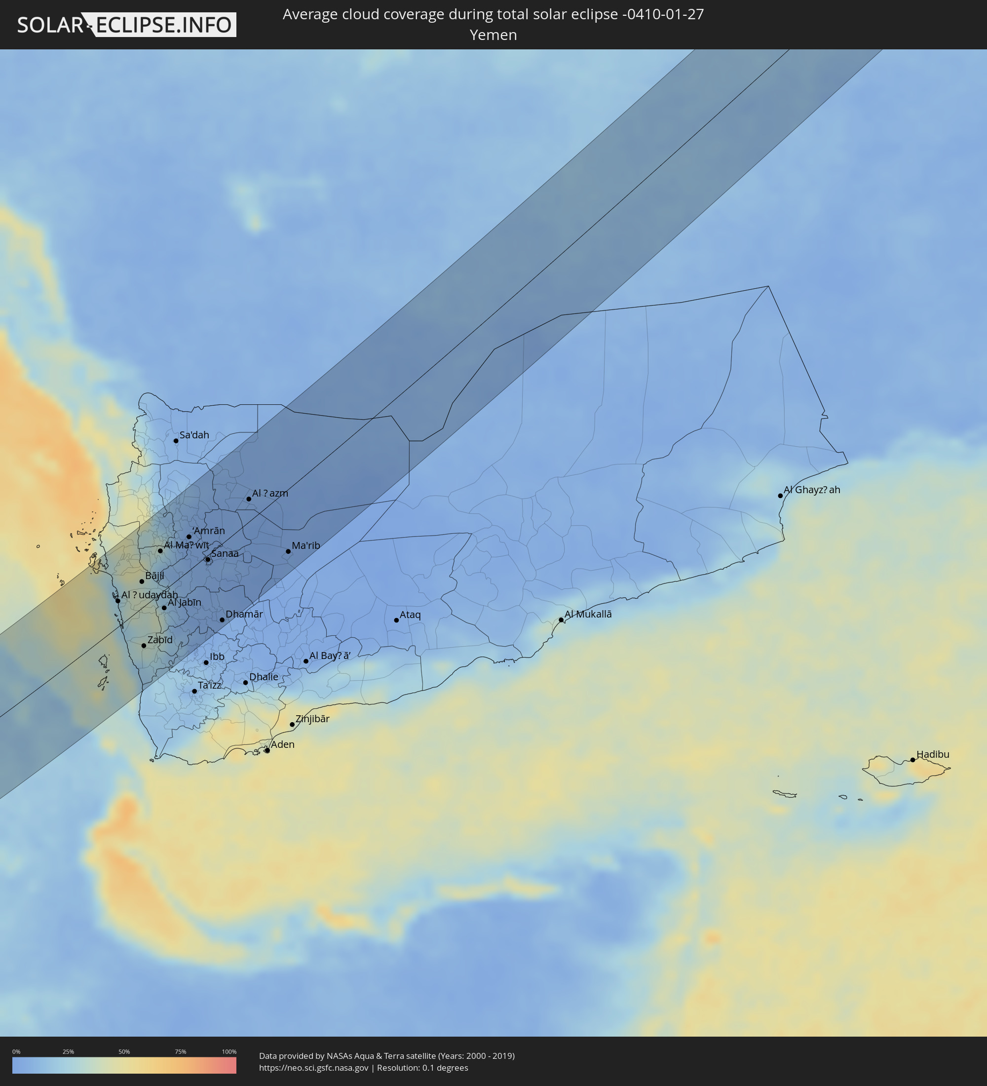 Jemen
Jemen
 Iran
Iran
 Kasachstan
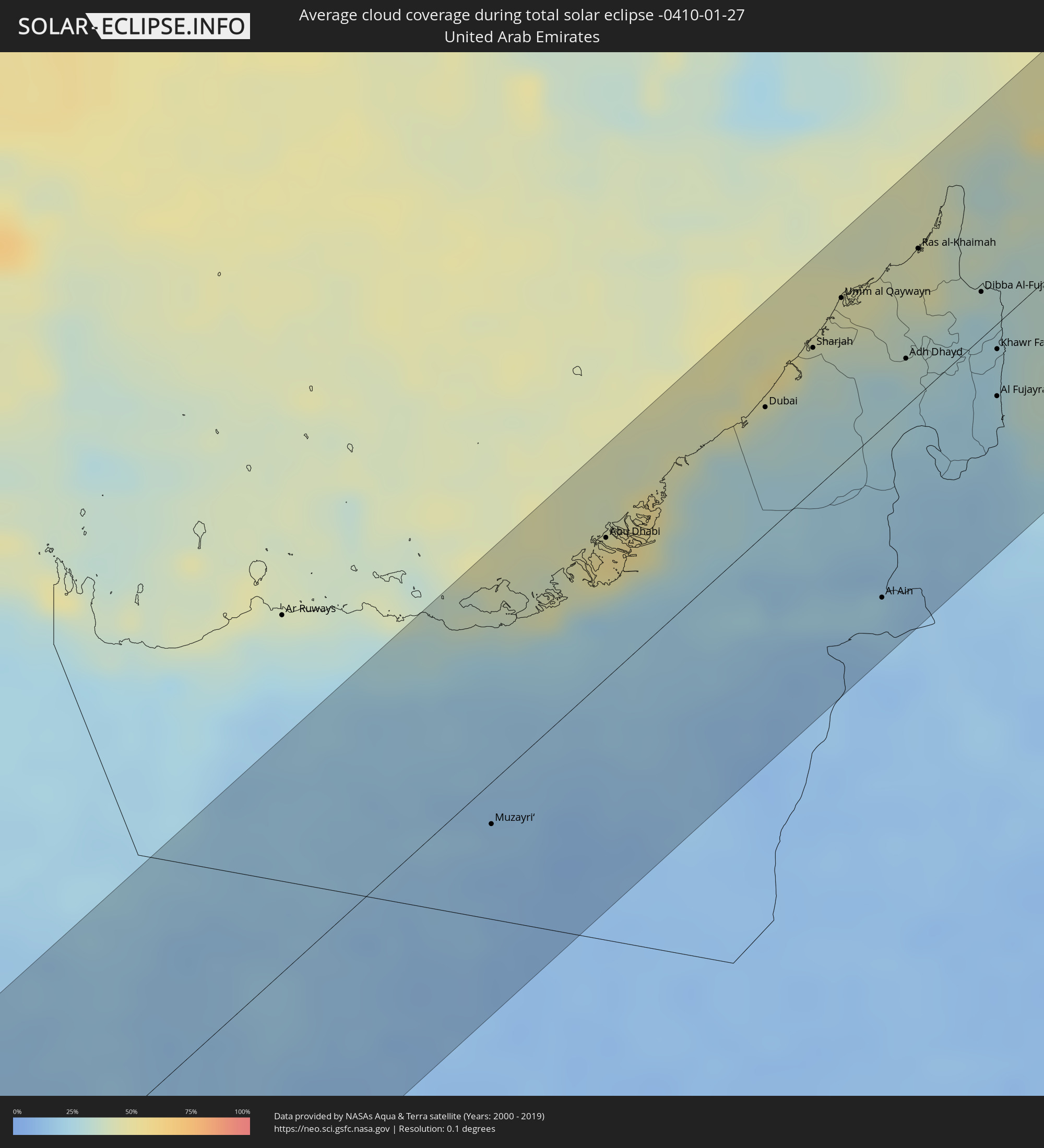 Vereinigte Arabische Emirate
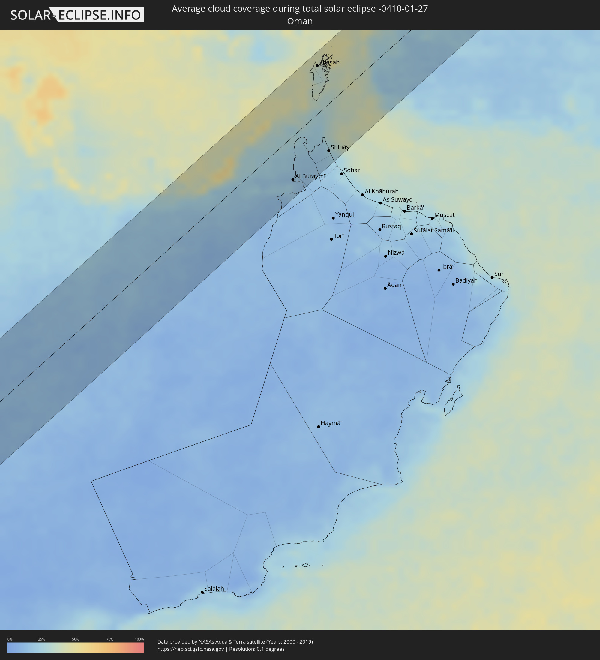 Oman
Oman
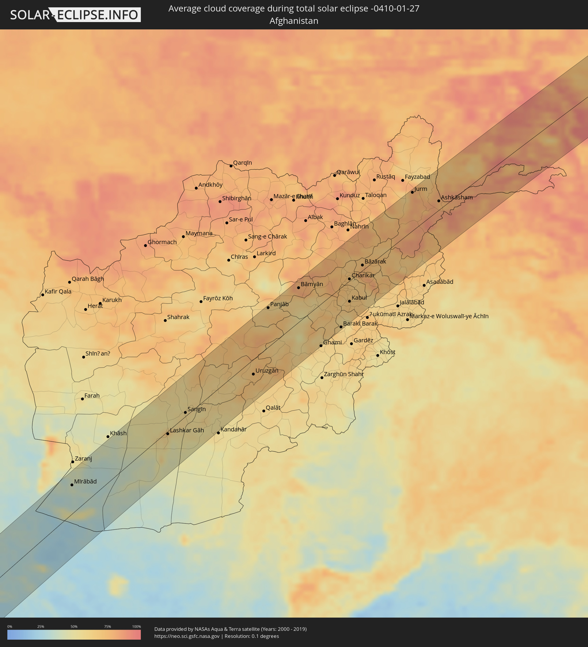 Afghanistan
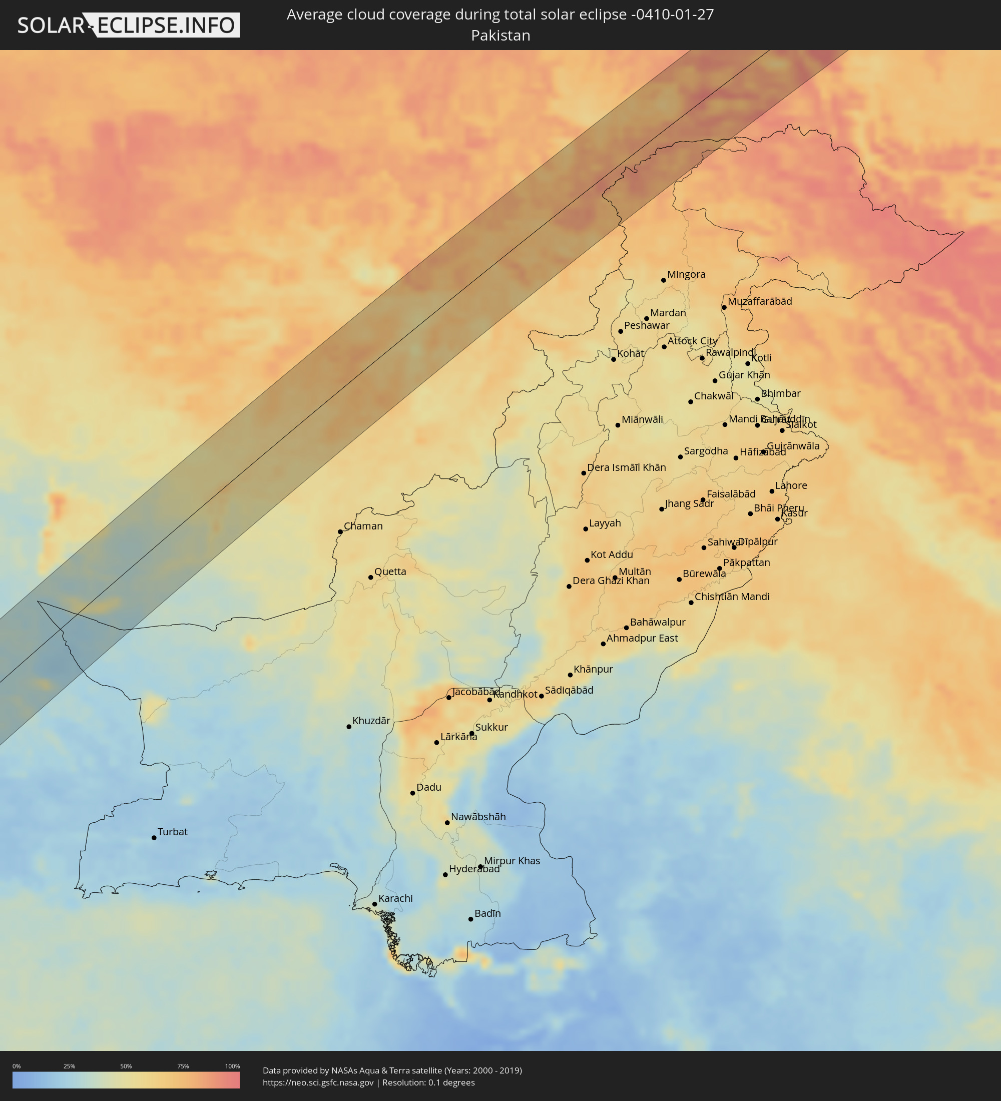 Pakistan
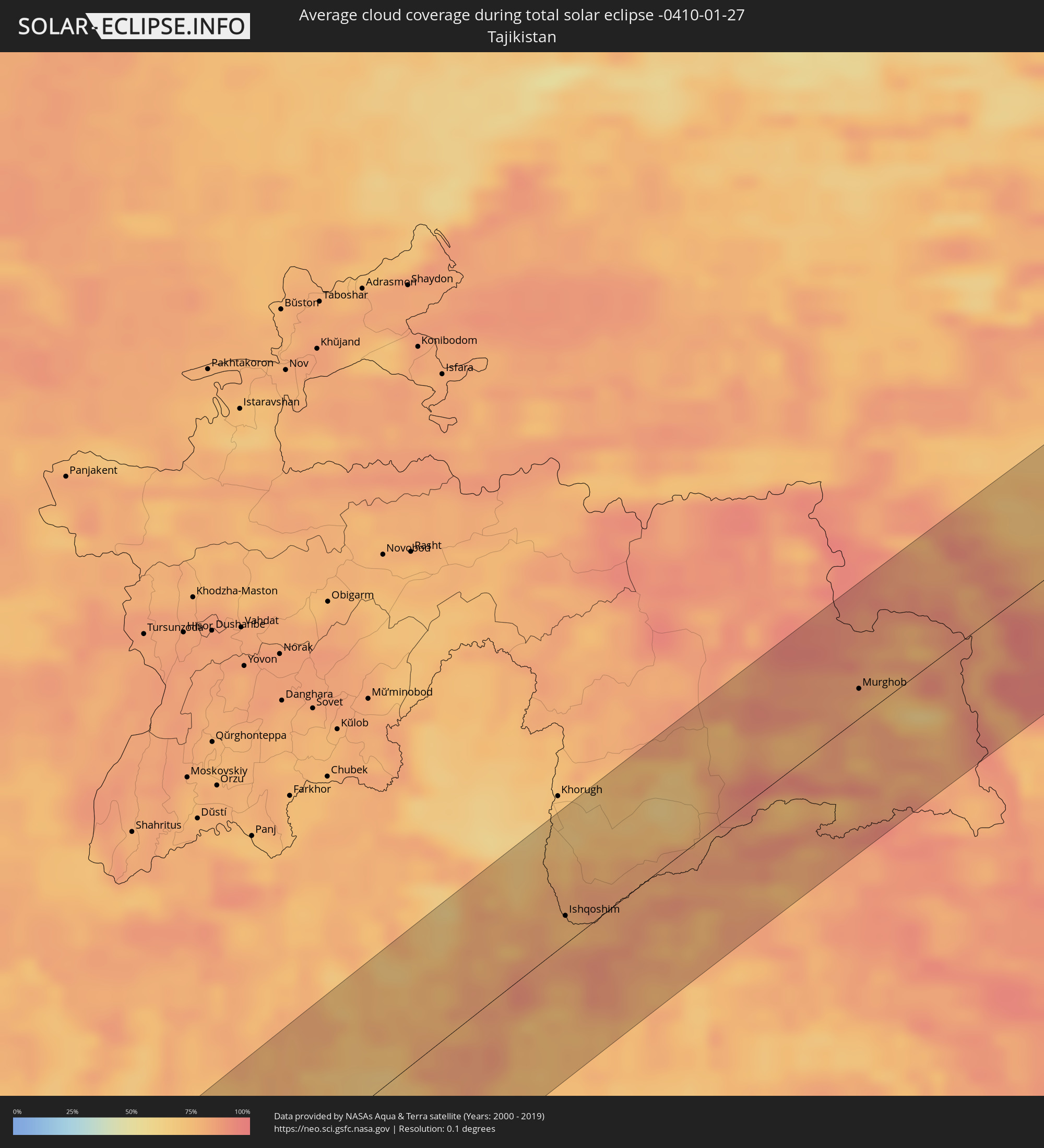 Tadschikistan
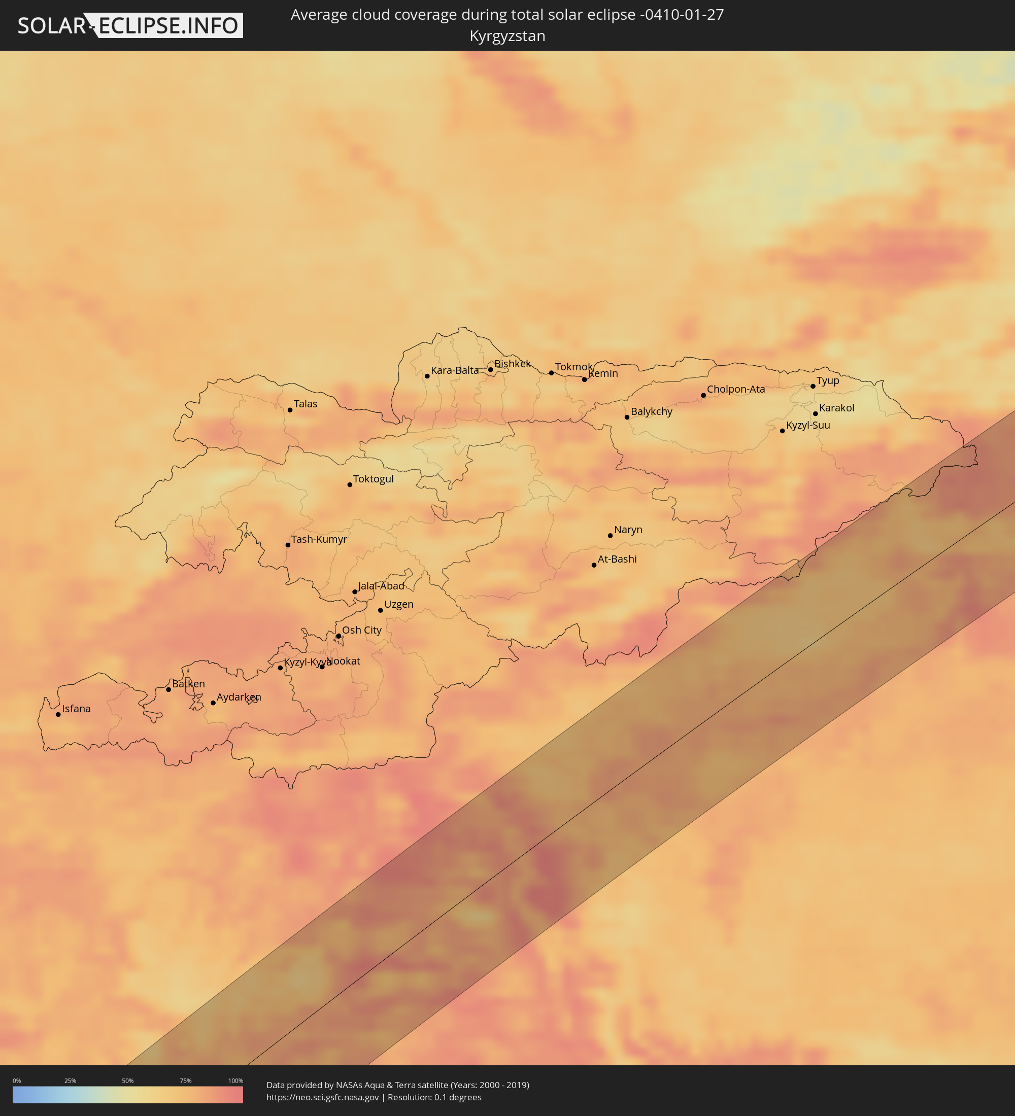 Kirgisistan
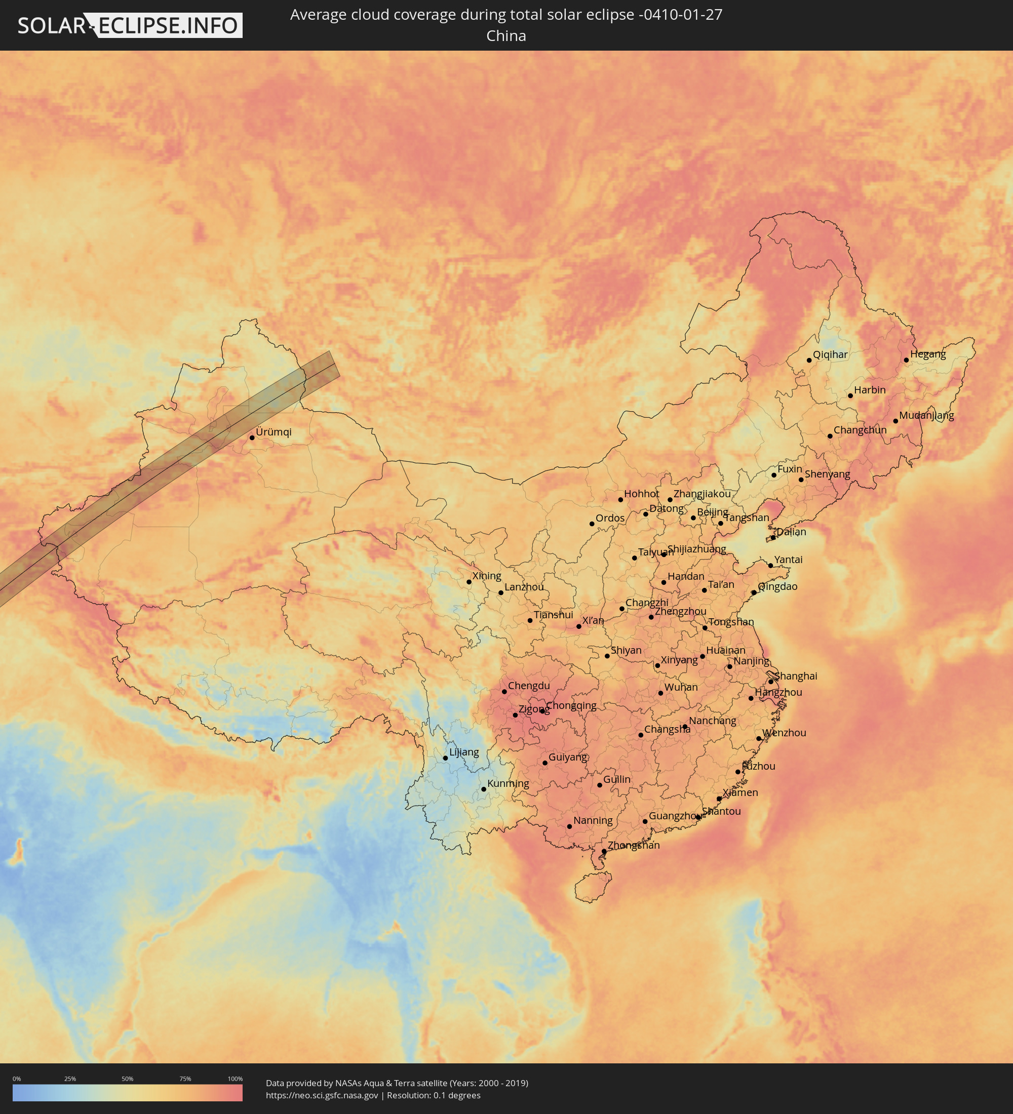 Volksrepublik China
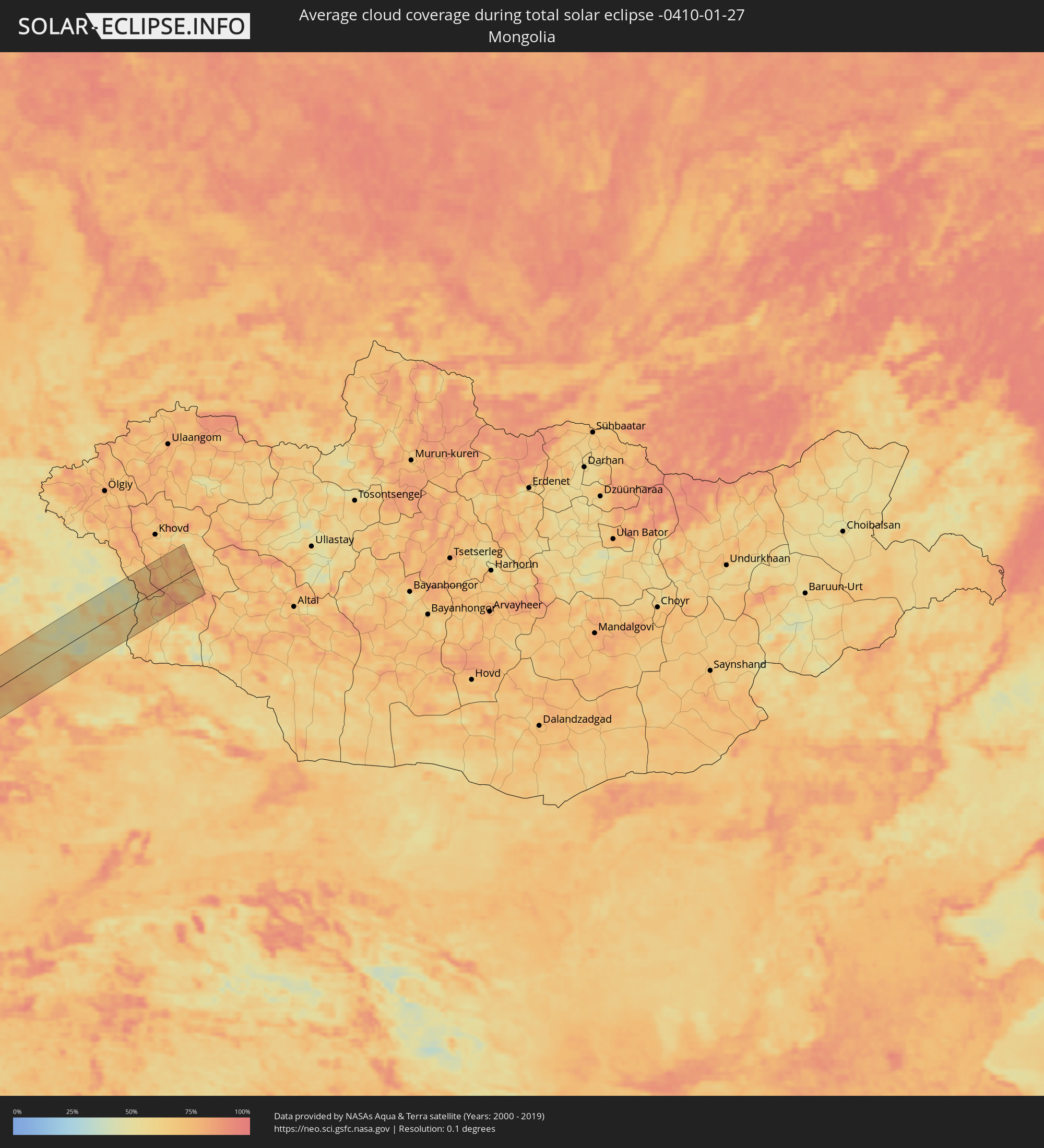 Mongolei
Orte im Finsternispfad
Die nachfolgene Tabelle zeigt Städte und Orte mit mehr als 5.000 Einwohnern, die sich im Finsternispfad befinden. Städte mit mehr als 100.000 Einwohnern sind dick gekennzeichnet. Mit einem Klick auf den Ort öffnet sich eine Detailkarte die die Lage des jeweiligen Ortes zusammen mit dem Verlauf der zentralen Finsternis präsentiert.
| Ort | Typ | Dauer der Verfinsterung | Ortszeit bei maximaler Verfinsterung | Entfernung zur Zentrallinie | Ø Bewölkung |
|
Quinhámel, Biombo
|
total | - | 06:36:56 UTC-01:02 | 24 km | 28% |
|
Bissau, Bissau
|
total | - | 06:36:59 UTC-01:02 | 17 km | 32% |
|
Bolama, Bolama and Bijagos
|
total | - | 06:36:48 UTC-01:02 | 42 km | 33% |
|
Bissorã, Oio
|
total | - | 06:37:17 UTC-01:02 | 26 km | 29% |
|
Mansôa, Oio
|
total | - | 06:37:13 UTC-01:02 | 16 km | 27% |
|
Catió, Tombali
|
total | - | 06:36:40 UTC-01:02 | 65 km | 33% |
|
Farim, Oio
|
total | - | 06:37:33 UTC-01:02 | 62 km | 25% |
|
Buba, Quinara
|
total | - | 06:36:58 UTC-01:02 | 23 km | 27% |
|
Quebo, Tombali
|
total | - | 06:36:48 UTC-01:02 | 47 km | 25% |
|
Bafatá, Bafatá
|
total | - | 06:37:29 UTC-01:02 | 50 km | 24% |
|
Boké, Boke
|
total | - | 07:22:55 UTC-00:16 | 65 km | 24% |
|
Gaoual, Boke
|
total | - | 07:23:54 UTC-00:16 | 61 km | 22% |
|
Télimélé, Kindia
|
total | - | 07:23:20 UTC-00:16 | 23 km | 23% |
|
Pita, Mamou
|
total | - | 07:23:42 UTC-00:16 | 17 km | 23% |
|
Labé, Labe
|
total | - | 07:23:56 UTC-00:16 | 49 km | 22% |
|
Mamou, Mamou
|
total | - | 07:23:20 UTC-00:16 | 44 km | 25% |
|
Dabola, Faranah
|
total | - | 07:24:02 UTC-00:16 | 30 km | 24% |
|
Faranah, Faranah
|
total | - | 07:23:42 UTC-00:16 | 31 km | 25% |
|
Kouroussa, Kankan
|
total | - | 07:24:34 UTC-00:16 | 64 km | 19% |
|
Kankan, Kankan
|
total | - | 07:24:40 UTC-00:16 | 56 km | 21% |
|
Odienné, Denguélé
|
total | - | 07:25:02 UTC-00:16 | 22 km | 16% |
|
Boundiali, Savanes
|
total | - | 07:25:44 UTC-00:16 | 59 km | 15% |
|
Katiola, Vallée du Bandama
|
total | - | 07:25:42 UTC-00:16 | 43 km | 33% |
|
Dabakala, Vallée du Bandama
|
total | - | 07:26:21 UTC-00:16 | 2 km | 32% |
|
Tanda, Zanzan
|
total | - | 07:26:57 UTC-00:16 | 20 km | 41% |
|
Bondoukou, Zanzan
|
total | - | 07:27:25 UTC-00:16 | 17 km | 41% |
|
Berekum, Brong-Ahafo
|
total | - | 07:42:27 UTC-00:00 | 40 km | 42% |
|
Sunyani, Brong-Ahafo
|
total | - | 07:42:35 UTC-00:00 | 45 km | 50% |
|
Wenchi, Brong-Ahafo
|
total | - | 07:43:04 UTC-00:00 | 5 km | 35% |
|
Techiman, Brong-Ahafo
|
total | - | 07:43:05 UTC-00:00 | 7 km | 35% |
|
Kintampo, Brong-Ahafo
|
total | - | 07:43:37 UTC-00:00 | 50 km | 30% |
|
Mampong, Ashanti
|
total | - | 07:43:12 UTC-00:00 | 48 km | 43% |
|
Ejura, Ashanti
|
total | - | 07:43:28 UTC-00:00 | 12 km | 38% |
|
Agogo, Ashanti
|
total | - | 07:43:18 UTC-00:00 | 67 km | 57% |
|
Ho, Volta
|
total | - | 07:44:39 UTC-00:00 | 46 km | 63% |
|
Hohoe, Volta
|
total | - | 07:45:03 UTC-00:00 | 13 km | 55% |
|
Badou, Plateaux
|
total | - | 07:30:14 UTC-00:16 | 63 km | 48% |
|
Kpalimé, Plateaux
|
total | - | 07:29:46 UTC-00:16 | 10 km | 58% |
|
Amlamé, Plateaux
|
total | - | 07:30:27 UTC-00:16 | 59 km | 38% |
|
Atakpamé, Plateaux
|
total | - | 07:30:45 UTC-00:16 | 72 km | 37% |
|
Notsé, Plateaux
|
total | - | 07:30:21 UTC-00:16 | 10 km | 51% |
|
Lomé, Maritime
|
total | - | 07:29:48 UTC-00:16 | 77 km | 90% |
|
Tsévié, Maritime
|
total | - | 07:30:01 UTC-00:16 | 46 km | 76% |
|
Tabligbo, Maritime
|
total | - | 07:30:26 UTC-00:16 | 21 km | 73% |
|
Vogan, Maritime
|
total | - | 07:30:17 UTC-00:16 | 48 km | 72% |
|
Aného, Maritime
|
total | - | 07:30:16 UTC-00:16 | 58 km | 90% |
|
Lokossa, Mono
|
total | - | 08:00:25 UTC+00:13 | 10 km | 73% |
|
Dogbo, Kouffo
|
total | - | 08:00:37 UTC+00:13 | 11 km | 70% |
|
Comé, Mono
|
total | - | 08:00:25 UTC+00:13 | 31 km | 73% |
|
Bohicon, Zou
|
total | - | 08:01:12 UTC+00:13 | 57 km | 59% |
|
Ouidah, Atlantique
|
total | - | 08:00:37 UTC+00:13 | 31 km | 80% |
|
Cové, Zou
|
total | - | 08:01:32 UTC+00:13 | 69 km | 63% |
|
Cotonou, Littoral
|
total | - | 08:00:59 UTC+00:13 | 22 km | 83% |
|
Porto-Novo, Ouémé
|
total | - | 08:01:17 UTC+00:13 | 3 km | 78% |
|
Sakété, Plateau
|
total | - | 08:01:31 UTC+00:13 | 24 km | 78% |
|
Pobé, Plateau
|
total | - | 08:01:43 UTC+00:13 | 51 km | 70% |
|
Ikeja, Lagos
|
total | - | 08:02:12 UTC+00:13 | 25 km | 79% |
|
Lagos, Lagos
|
total | - | 08:02:09 UTC+00:13 | 11 km | 81% |
|
Ebute Ikorodu, Lagos
|
total | - | 08:02:22 UTC+00:13 | 29 km | 83% |
|
Benin City, Edo
|
total | - | 08:04:49 UTC+00:13 | 47 km | 80% |
|
Warri, Delta
|
total | - | 08:04:21 UTC+00:13 | 40 km | 86% |
|
Onitsha, Anambra
|
total | - | 08:06:13 UTC+00:13 | 49 km | 78% |
|
Aba, Abia
|
total | - | 08:06:13 UTC+00:13 | 55 km | 83% |
|
Umuahia, Abia
|
total | - | 08:06:43 UTC+00:13 | 7 km | 84% |
|
Uyo, Akwa Ibom
|
total | - | 08:06:58 UTC+00:13 | 51 km | 84% |
|
Calabar, Cross River
|
total | - | 08:07:28 UTC+00:13 | 55 km | 84% |
|
Kumba, South-West
|
total | - | 08:08:52 UTC+00:13 | 73 km | 88% |
|
Loum, Littoral
|
total | - | 08:09:22 UTC+00:13 | 60 km | 89% |
|
Nkongsamba, Littoral
|
total | - | 08:09:53 UTC+00:13 | 31 km | 81% |
|
Dschang, West
|
total | - | 08:10:27 UTC+00:13 | 24 km | 56% |
|
Bamenda, North-West
|
total | - | 08:11:02 UTC+00:13 | 83 km | 47% |
|
Mbouda, West
|
total | - | 08:10:55 UTC+00:13 | 47 km | 44% |
|
Bafoussam, West
|
total | - | 08:11:03 UTC+00:13 | 33 km | 46% |
|
Foumbot, West
|
total | - | 08:11:26 UTC+00:13 | 39 km | 47% |
|
Foumban, West
|
total | - | 08:12:03 UTC+00:13 | 66 km | 44% |
|
Bertoua, East
|
total | - | 08:15:49 UTC+00:13 | 35 km | 68% |
|
Berbérati, Mambéré-Kadéï
|
total | - | 08:19:26 UTC+00:13 | 61 km | 56% |
|
Carnot, Mambéré-Kadéï
|
total | - | 08:20:14 UTC+00:13 | 15 km | 50% |
|
Boda, Lobaye
|
total | - | 08:22:47 UTC+00:13 | 55 km | 55% |
|
Bimbo, Ombella-M'Poko
|
total | - | 08:24:40 UTC+00:13 | 64 km | 57% |
|
Bangui, Bangui
|
total | - | 08:25:03 UTC+00:13 | 53 km | 57% |
|
Damara, Ombella-M'Poko
|
total | - | 08:25:58 UTC+00:13 | 13 km | 51% |
|
Sibut, Kémo
|
total | - | 08:27:32 UTC+00:13 | 95 km | 45% |
|
Bosobolo, Équateur
|
total | - | 08:27:42 UTC+00:13 | 81 km | 55% |
|
Bambari, Ouaka
|
total | - | 08:31:06 UTC+00:13 | 87 km | 45% |
|
Gbadolite, Équateur
|
total | - | 08:30:15 UTC+00:13 | 81 km | 59% |
|
Mobaye, Basse-Kotto
|
total | - | 08:30:41 UTC+00:13 | 79 km | 59% |
|
Bangassou, Mbomou
|
total | - | 08:34:53 UTC+00:13 | 55 km | 61% |
 Tambura, Western Equatoria
|
total | - | 10:40:06 UTC+02:06 | 67 km | 41% |
|
Tonj, Warrap
|
total | - | 10:45:20 UTC+02:06 | 72 km | 26% |
|
Rumbek, Lakes
|
total | - | 10:47:20 UTC+02:06 | 13 km | 29% |
|
Āsosa, Bīnshangul Gumuz
|
total | - | 11:25:26 UTC+02:27 | 102 km | 16% |
|
Gambēla, Gambela
|
total | - | 11:23:02 UTC+02:27 | 80 km | 26% |
|
Dembī Dolo, Oromiya
|
total | - | 11:24:00 UTC+02:27 | 63 km | 32% |
|
Gimbi, Oromiya
|
total | - | 11:27:38 UTC+02:27 | 54 km | 19% |
|
Bahir Dar, Amhara
|
total | - | 11:35:08 UTC+02:27 | 90 km | 7% |
|
Debre Mark’os, Amhara
|
total | - | 11:34:17 UTC+02:27 | 47 km | 17% |
|
Debre Tabor, Amhara
|
total | - | 11:37:07 UTC+02:27 | 77 km | 18% |
|
Korem, Tigray
|
total | - | 11:41:55 UTC+02:27 | 46 km | 25% |
|
Maych’ew, Tigray
|
total | - | 11:42:21 UTC+02:27 | 71 km | 18% |
|
Desē, Amhara
|
total | - | 11:40:17 UTC+02:27 | 87 km | 17% |
|
Edd, Southern Red Sea
|
total | - | 11:49:18 UTC+02:27 | 36 km | 21% |
|
Al Ḩudaydah, Muḩāfaz̧at al Ḩudaydah
|
total | - | 12:33:08 UTC+03:06 | 30 km | 25% |
|
Bājil, Muḩāfaz̧at al Ḩudaydah
|
total | - | 12:34:16 UTC+03:06 | 30 km | 36% |
|
Zabīd, Muḩāfaz̧at al Ḩudaydah
|
total | - | 12:33:12 UTC+03:06 | 47 km | 29% |
|
Bayt al Faqīh, Muḩāfaz̧at al Ḩudaydah
|
total | - | 12:33:39 UTC+03:06 | 20 km | 31% |
|
Ḩajjah, Ḩajjah
|
total | - | 12:35:50 UTC+03:06 | 64 km | 32% |
|
‘Amrān, Omran
|
total | - | 12:36:36 UTC+03:06 | 38 km | 4% |
|
Sanaa, Sanaa
|
total | - | 12:36:49 UTC+03:06 | 6 km | 5% |
|
Saḩar, Sanaa
|
total | - | 12:37:01 UTC+03:06 | 16 km | 4% |
|
Sayyān, Sanaa
|
total | - | 12:36:52 UTC+03:06 | 30 km | 4% |
|
Dhamār, Dhamār
|
total | - | 12:36:15 UTC+03:06 | 90 km | 4% |
|
Abu Dhabi, Abu Dhabi
|
total | - | 13:41:21 UTC+03:41 | 53 km | 55% |
|
Dubai, Dubai
|
total | - | 13:43:10 UTC+03:41 | 48 km | 35% |
|
Sharjah, Ash Shāriqah
|
total | - | 13:43:45 UTC+03:41 | 54 km | 35% |
|
Ajman, Ajman
|
total | - | 13:43:51 UTC+03:41 | 58 km | 39% |
|
Umm al Qaywayn, Umm al Qaywayn
|
total | - | 13:44:09 UTC+03:41 | 63 km | 45% |
|
Al Ain, Abu Dhabi
|
total | - | 13:43:32 UTC+03:41 | 64 km | 17% |
|
Al Buraymī, Al Buraimi
|
total | - | 13:43:37 UTC+03:41 | 62 km | 19% |
|
Ras al-Khaimah, Raʼs al Khaymah
|
total | - | 13:44:57 UTC+03:41 | 55 km | 44% |
|
Khasab, Musandam
|
total | - | 13:45:42 UTC+03:41 | 67 km | 33% |
|
Dibba Al-Fujairah, Al Fujayrah
|
total | - | 13:45:20 UTC+03:41 | 17 km | 28% |
|
Al Fujayrah, Al Fujayrah
|
total | - | 13:45:09 UTC+03:41 | 27 km | 23% |
|
Khawr Fakkān, Ash Shāriqah
|
total | - | 13:45:18 UTC+03:41 | 10 km | 24% |
|
Shināş, Al Batinah North Governorate
|
total | - | 13:45:06 UTC+03:41 | 67 km | 23% |
|
Zahedan, Sistan and Baluchestan
|
total | - | 13:38:51 UTC+03:25 | 38 km | 31% |
|
Mīrābād, Nimroz
|
total | - | 14:14:47 UTC+04:00 | 55 km | 38% |
|
Lashkar Gāh, Helmand
|
total | - | 14:18:19 UTC+04:00 | 5 km | 56% |
|
Gereshk, Helmand
|
total | - | 14:18:37 UTC+04:00 | 2 km | 56% |
|
Sangīn, Helmand
|
total | - | 14:18:59 UTC+04:00 | 7 km | 58% |
|
Bāmyān, Bamyan
|
total | - | 14:22:39 UTC+04:00 | 64 km | 78% |
|
Barakī Barak, Logar
|
total | - | 14:23:46 UTC+04:00 | 75 km | 63% |
|
Paghmān, Kabul
|
total | - | 14:23:48 UTC+04:00 | 21 km | 64% |
|
Charikar, Parwan
|
total | - | 14:24:02 UTC+04:00 | 3 km | 67% |
|
Kabul, Kabul
|
total | - | 14:24:01 UTC+04:00 | 39 km | 69% |
|
Bāzārak, Panjshir
|
total | - | 14:24:22 UTC+04:00 | 10 km | 76% |
|
Ishqoshim, Gorno-Badakhshan
|
total | - | 15:01:28 UTC+04:35 | 16 km | 76% |
|
Murghob, Gorno-Badakhshan
|
total | - | 15:03:15 UTC+04:35 | 16 km | 78% |
|
Kashgar, Xinjiang Uyghur Autonomous Region
|
total | - | 18:29:19 UTC+08:00 | 27 km | 82% |
|
Aykol, Xinjiang Uyghur Autonomous Region
|
total | - | 18:31:37 UTC+08:00 | 43 km | 84% |
|
Aksu, Xinjiang Uyghur Autonomous Region
|
total | - | 18:31:37 UTC+08:00 | 29 km | 83% |
|
Shihezi, Xinjiang Uyghur Autonomous Region
|
total | - | 18:33:09 UTC+08:00 | 1 km | 77% |