Totale Sonnenfinsternis vom 05.01.-0446
| Wochentag: | Montag |
| Maximale Dauer der Verfinsterung: | 04m24s |
| Maximale Breite des Finsternispfades: | 186 km |
| Saroszyklus: | 63 |
| Bedeckungsgrad: | 100% |
| Magnitude: | 1.0465 |
| Gamma: | 0.5588 |
Wo kann man die Sonnenfinsternis vom 05.01.-0446 sehen?
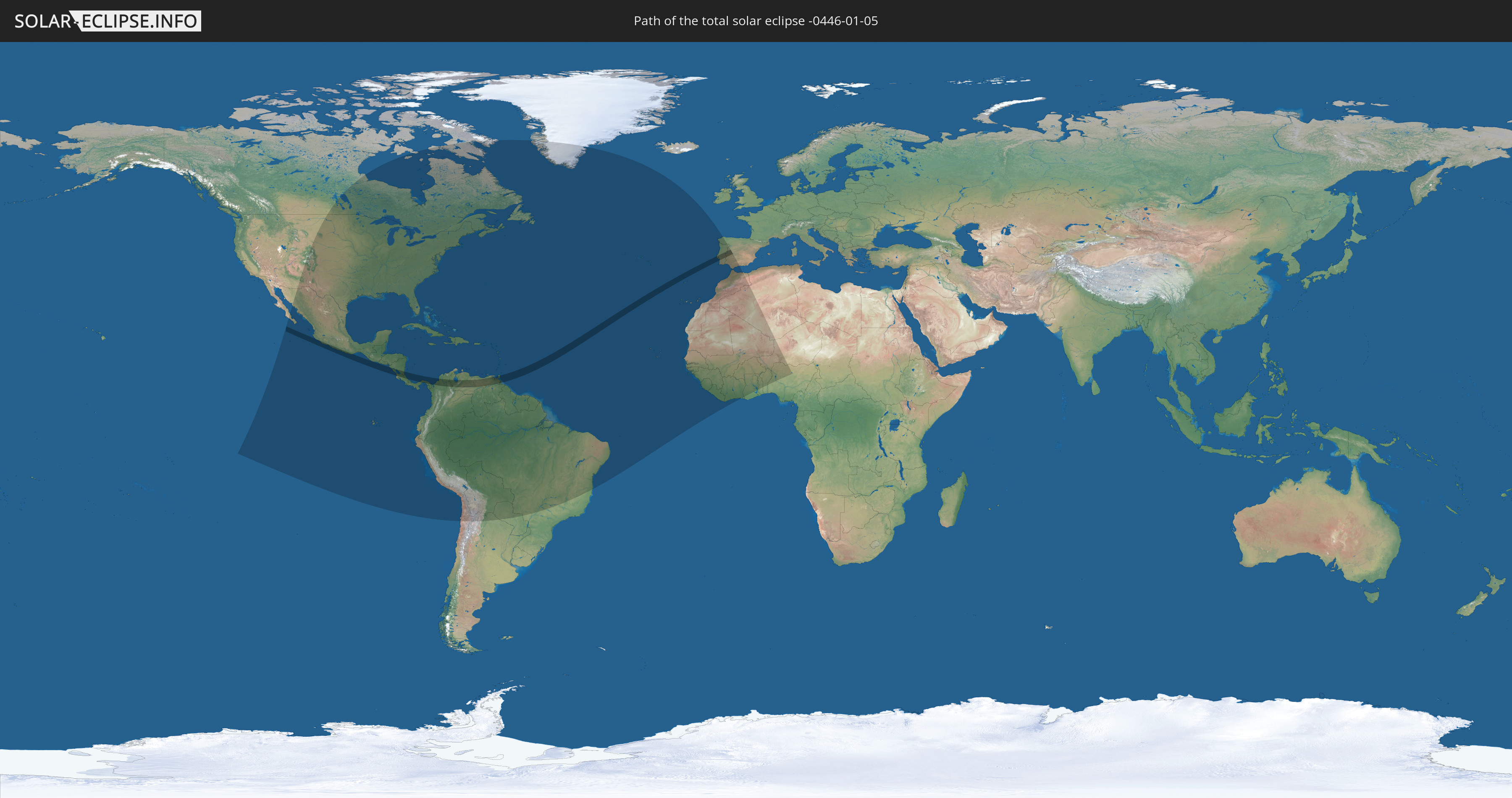
Die Sonnenfinsternis am 05.01.-0446 kann man in 72 Ländern als partielle Sonnenfinsternis beobachten.
Der Finsternispfad verläuft durch 9 Länder. Nur in diesen Ländern ist sie als totale Sonnenfinsternis zu sehen.
In den folgenden Ländern ist die Sonnenfinsternis total zu sehen
 Mexiko
 Nicaragua
 Costa Rica
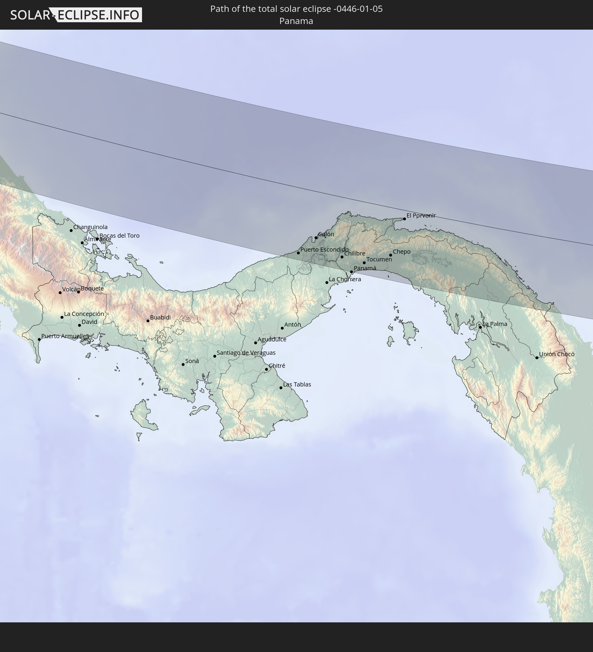 Panama
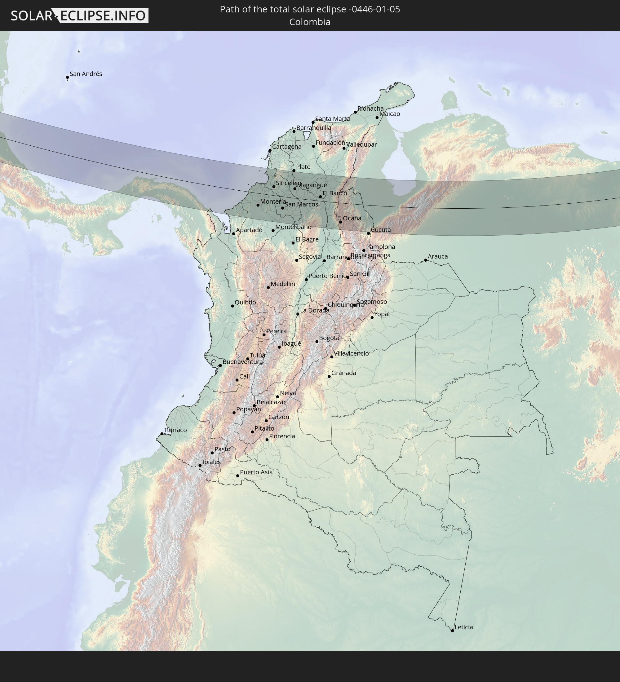 Kolumbien
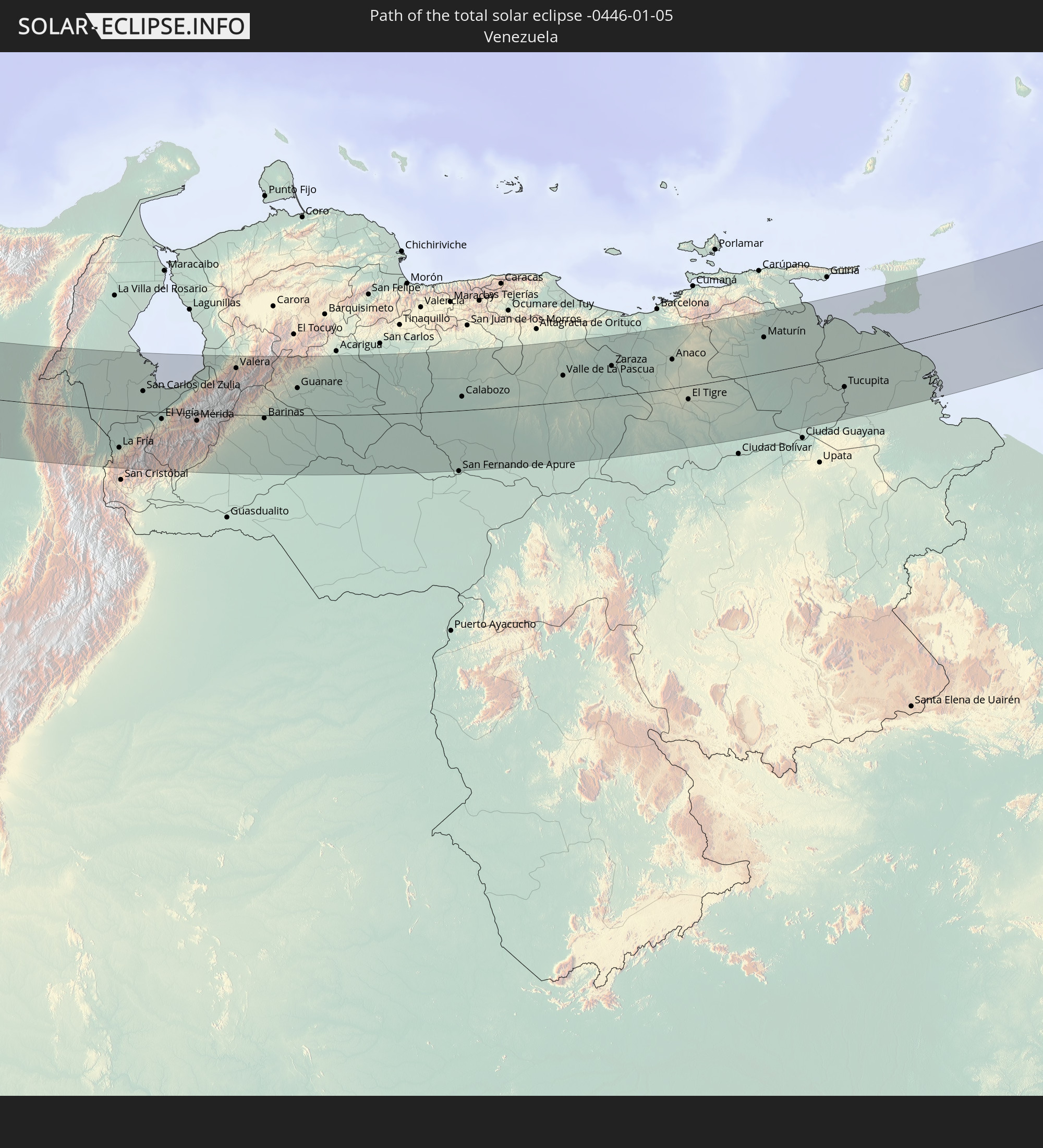 Venezuela
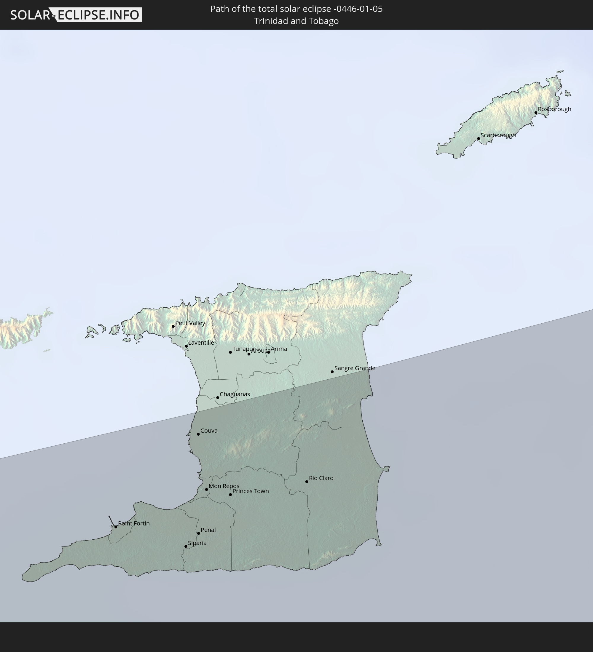 Trinidad und Tobago
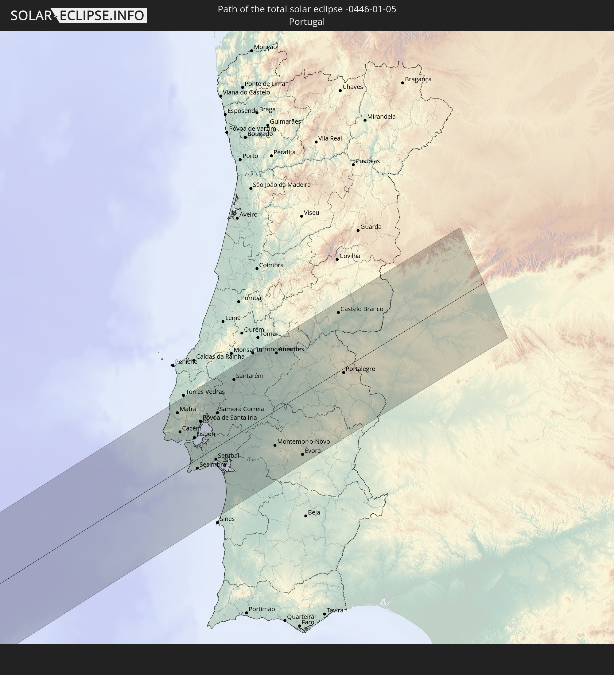 Portugal
 Spanien
In den folgenden Ländern ist die Sonnenfinsternis partiell zu sehen
 Vereinigte Staaten
 United States Minor Outlying Islands
 Kanada
 Mexiko
 Chile
Chile
 Grönland
 Guatemala
 Ecuador
 El Salvador
 Honduras
 Belize
 Nicaragua
 Costa Rica
 Kuba
Kuba
 Panama
 Kolumbien
 Kaimaninseln
 Peru
Peru
 Bahamas
 Jamaika
 Haiti
Haiti
 Brasilien
 Argentinien
 Venezuela
 Turks- und Caicosinseln
 Dominikanische Republik
 Aruba
Aruba
 Bolivien
 Puerto Rico
 Amerikanische Jungferninseln
 Bermuda
 Britische Jungferninseln
 Anguilla
 Saint-Martin
 Saint-Barthélemy
 St. Kitts und Nevis
 Paraguay
 Antigua und Barbuda
 Montserrat
 Trinidad und Tobago
 Guadeloupe
 Grenada
 Dominica
 St. Vincent und die Grenadinen
 Guyana
 Martinique
 St. Lucia
 Barbados
 Suriname
 Saint-Pierre und Miquelon
 Französisch-Guayana
 Portugal
 Kap Verde
 Spanien
 Senegal
 Mauretanien
 Gambia
 Guinea-Bissau
 Guinea
 Sierra Leone
 Marokko
 Mali
Mali
 Liberia
 Algerien
 Elfenbeinküste
 Burkina Faso
 Gibraltar
 Ghana
Ghana
 Togo
Togo
 Niger
Niger
 Benin
Benin
 Nigeria
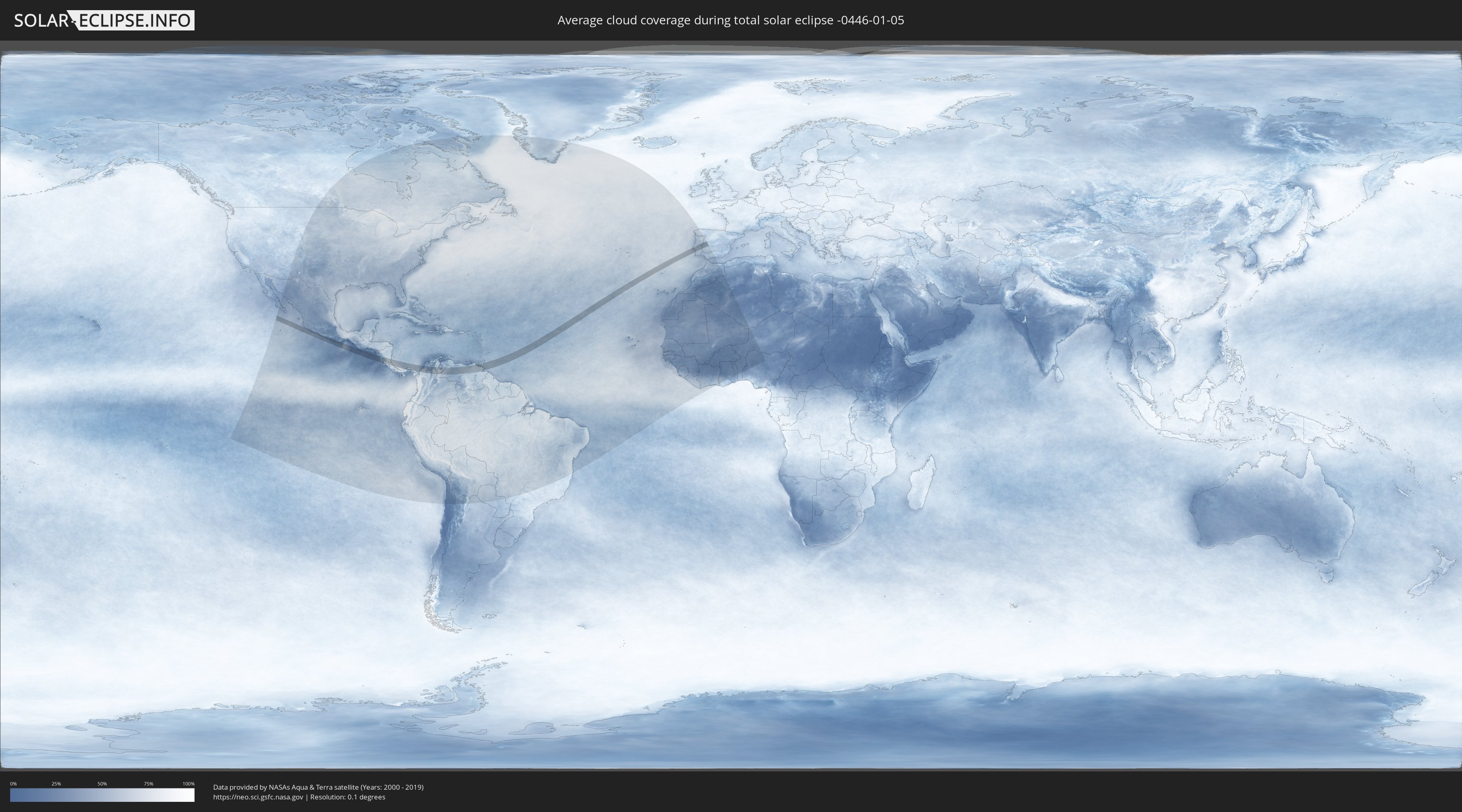
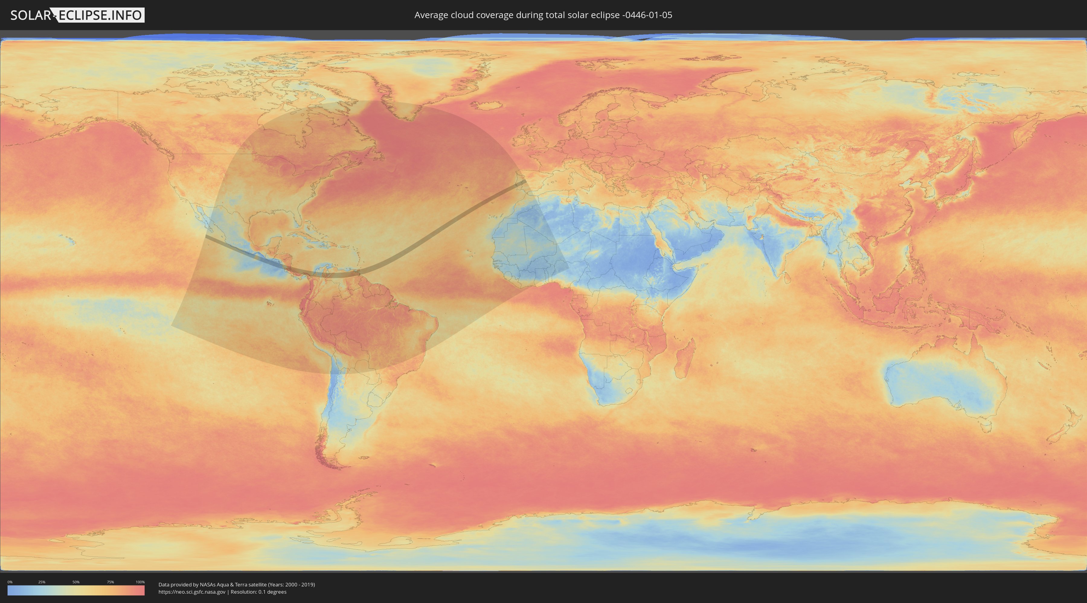
Wie wird das Wetter während der totalen Sonnenfinsternis am 05.01.-0446?
Wo ist der beste Ort, um die totale Sonnenfinsternis vom 05.01.-0446 zu beobachten?
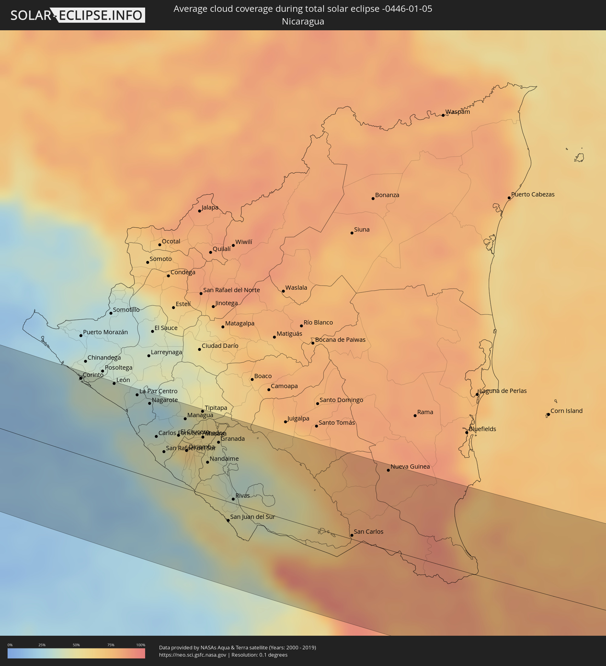
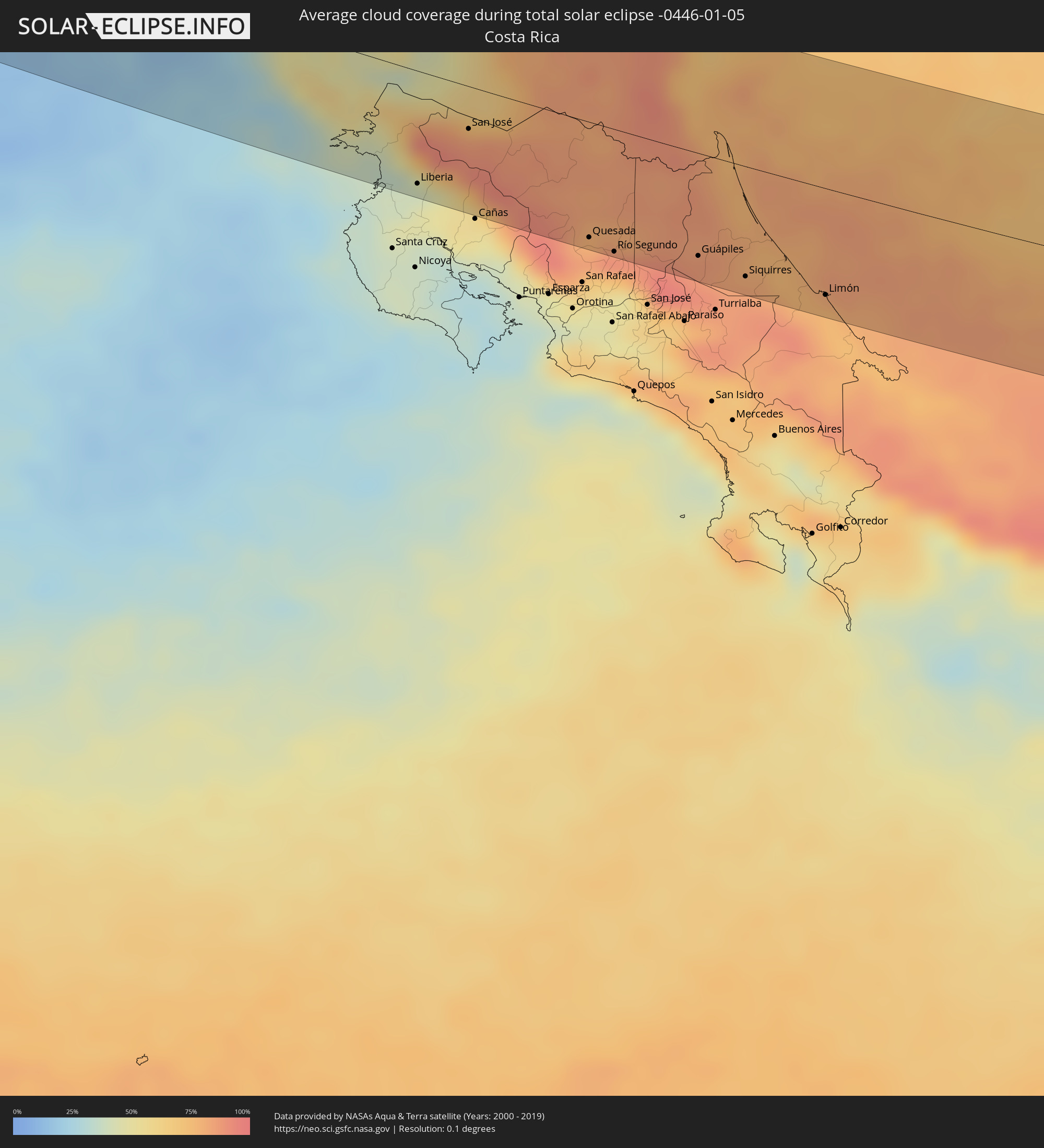
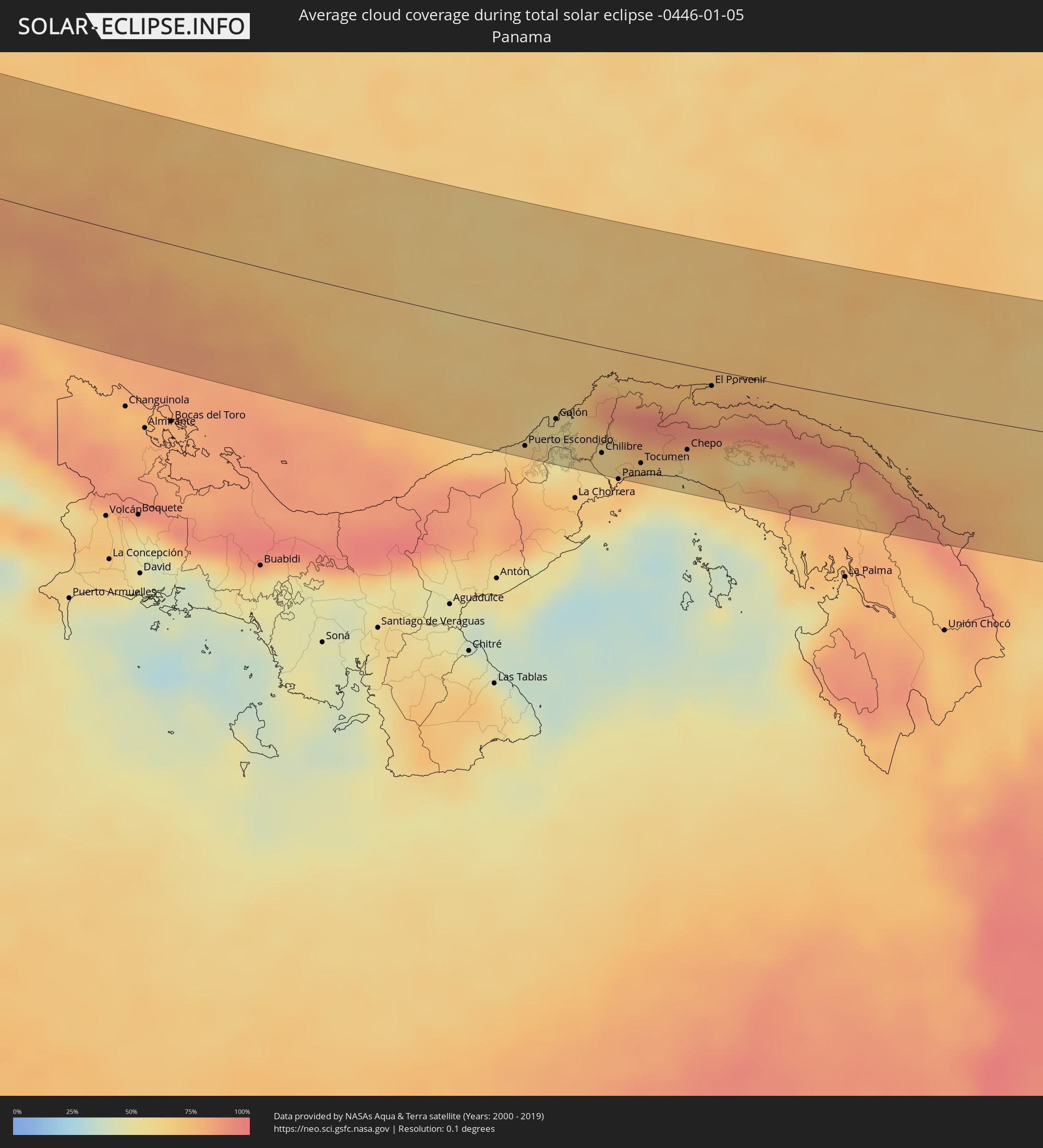
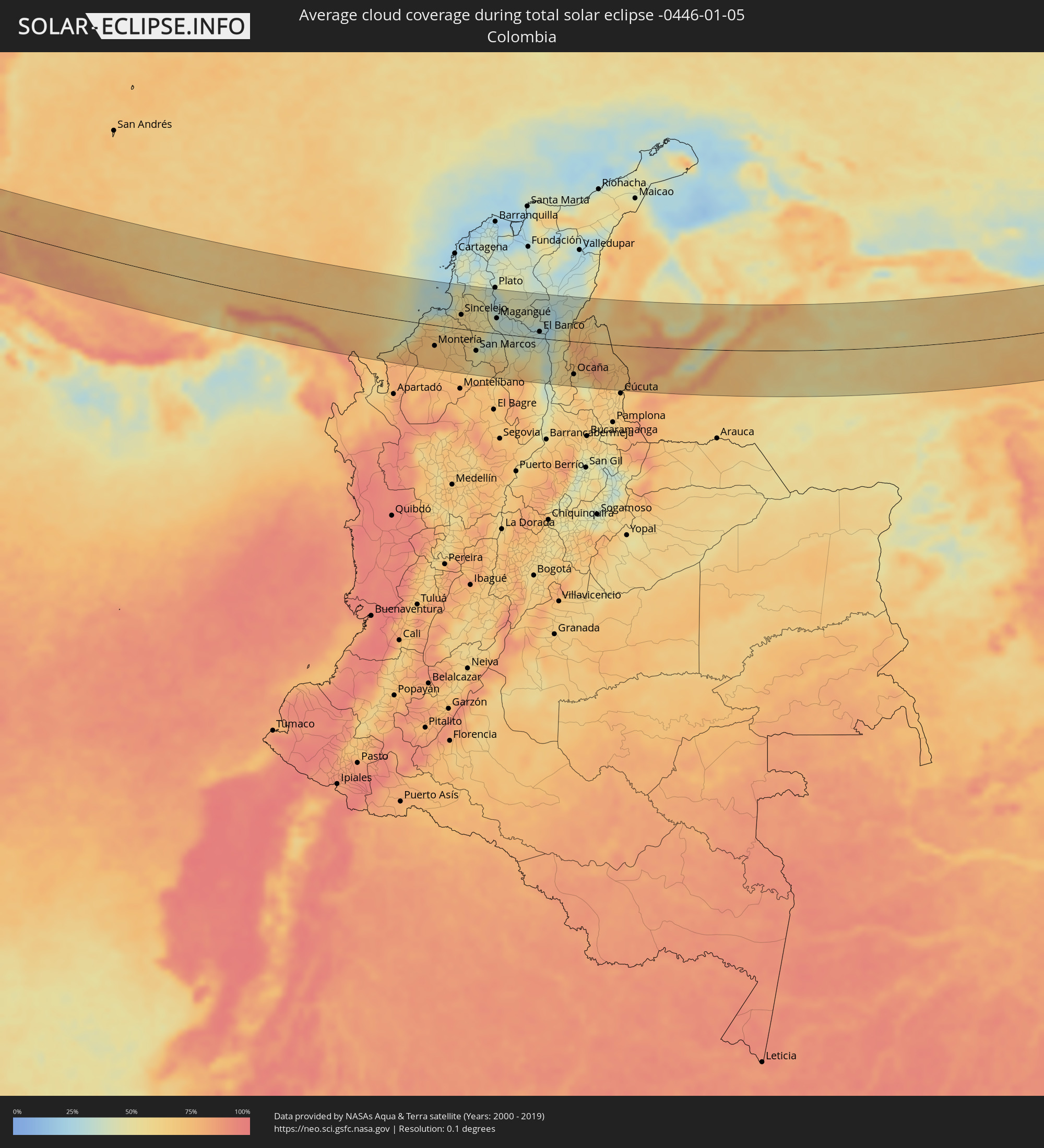
Die folgenden Karten zeigen die durchschnittliche Bewölkung für den Tag, an dem die totale Sonnenfinsternis
stattfindet. Mit Hilfe der Karten lässt sich der Ort entlang des Finsternispfades eingrenzen,
der die besten Aussichen auf einen klaren wolkenfreien Himmel bietet.
Trotzdem muss man immer lokale Gegenenheiten beachten und sollte sich genau über das Wetter an seinem
gewählten Beobachtungsort informieren.
Die Daten stammen von den beiden NASA-Satelliten
AQUA und TERRA
und wurden über einen Zeitraum von 19 Jahren (2000 - 2019) gemittelt.
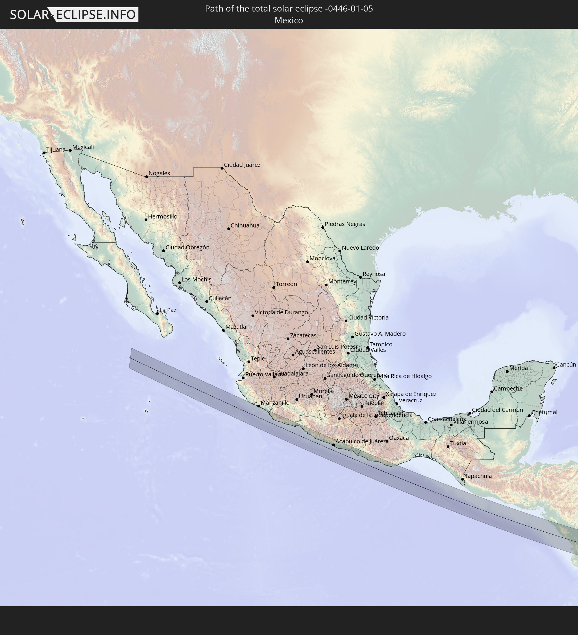
Detaillierte Länderkarten
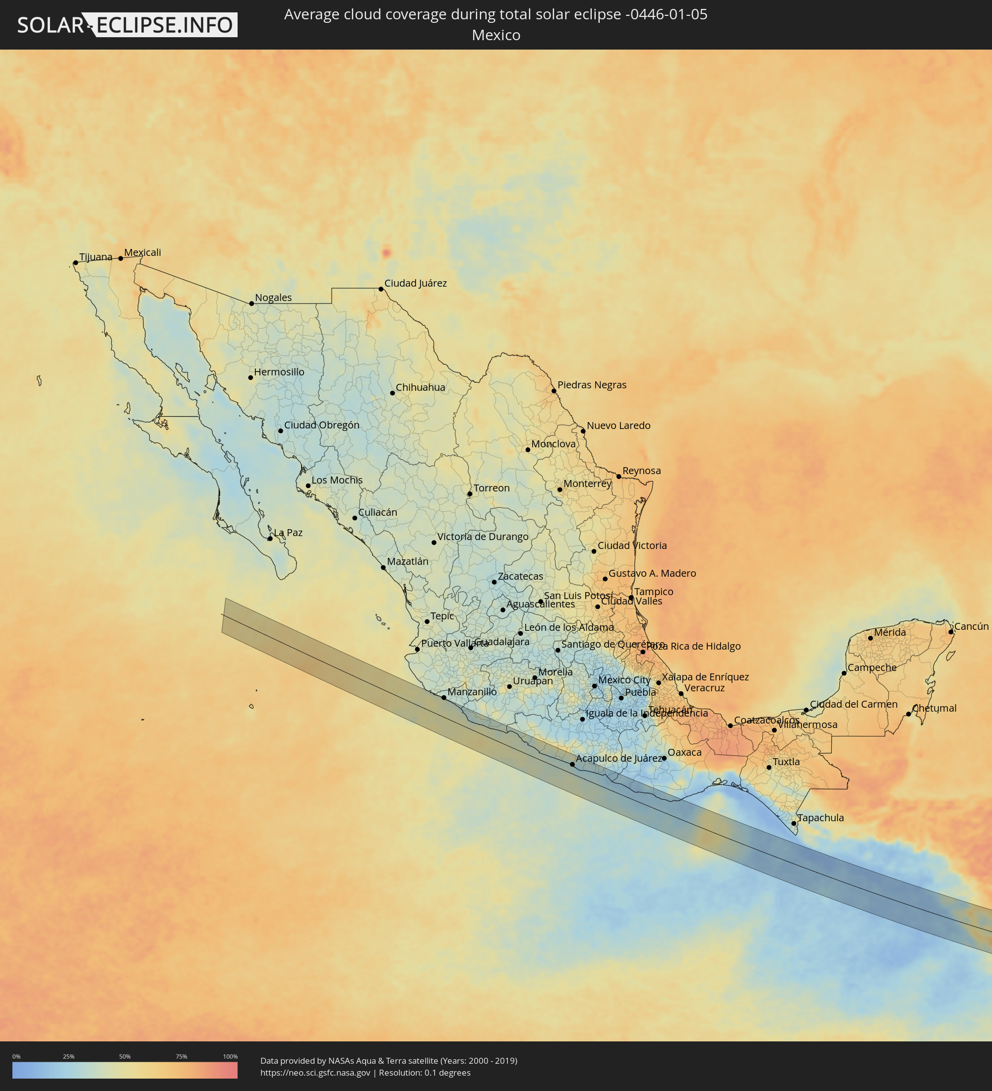 Mexiko
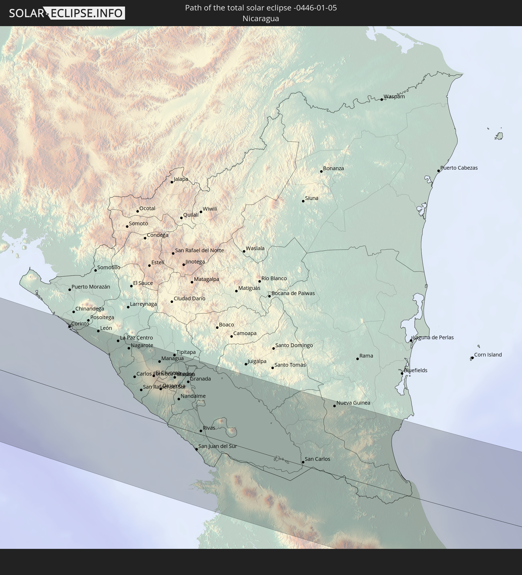
 Nicaragua
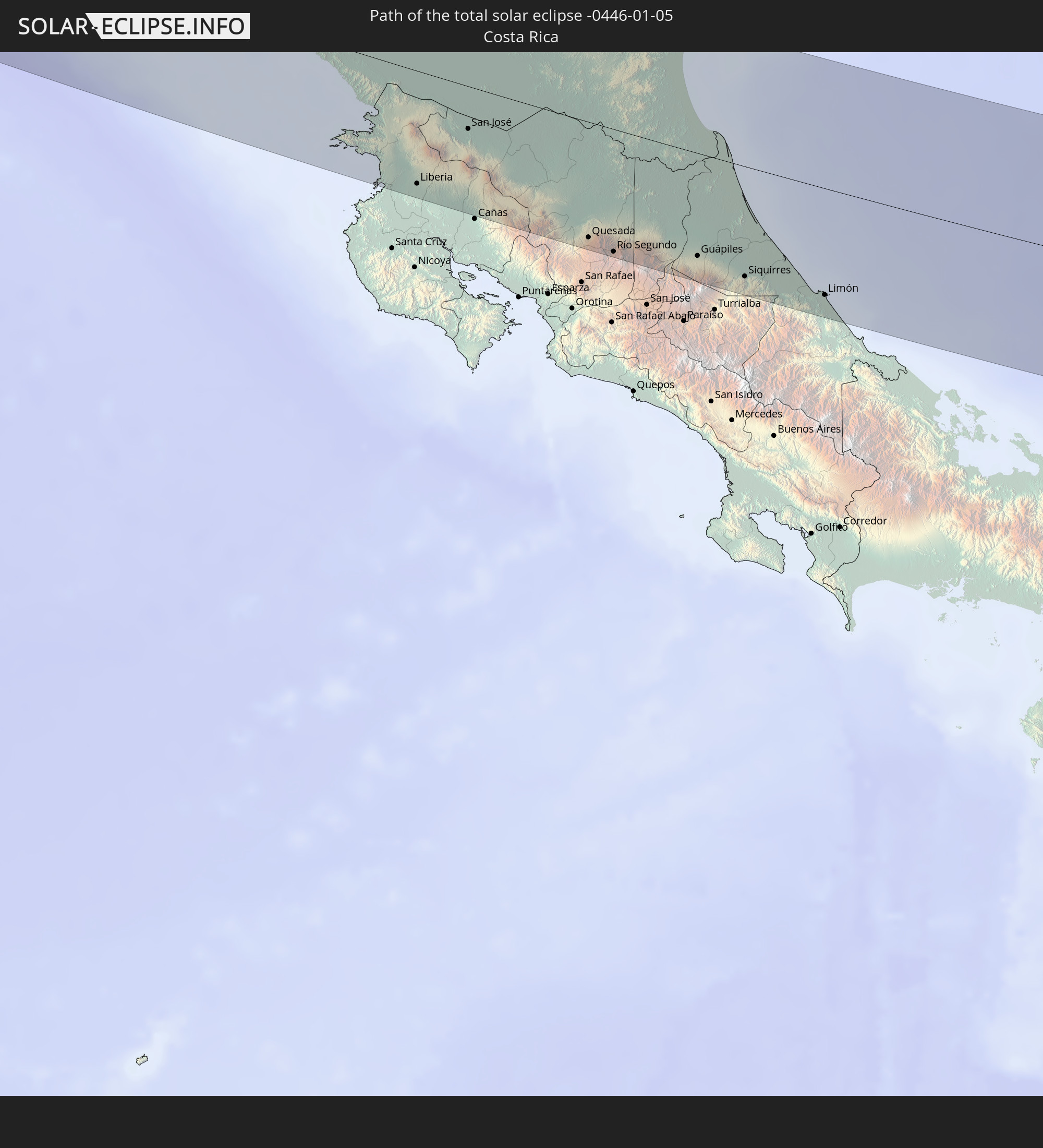
 Costa Rica
 Panama
 Kolumbien
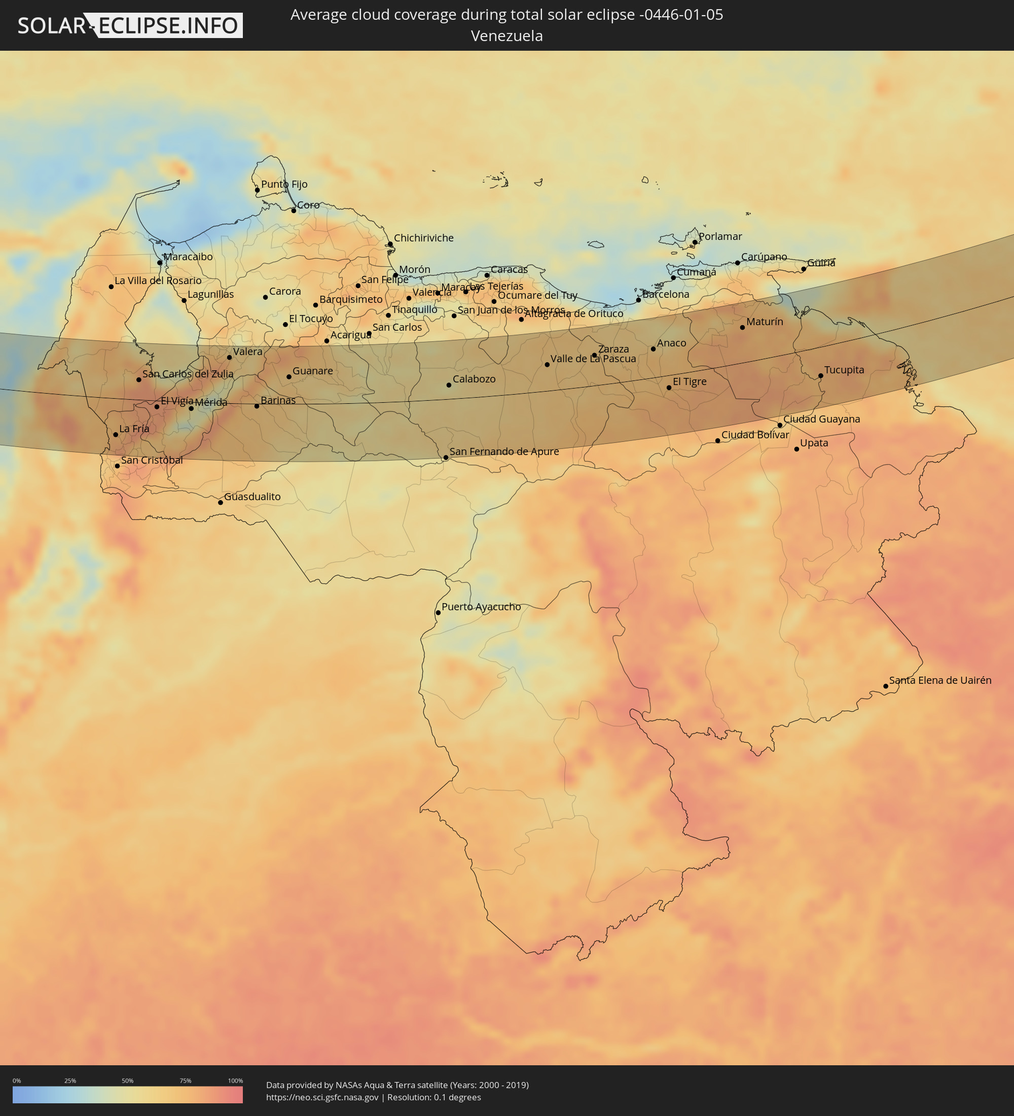 Venezuela
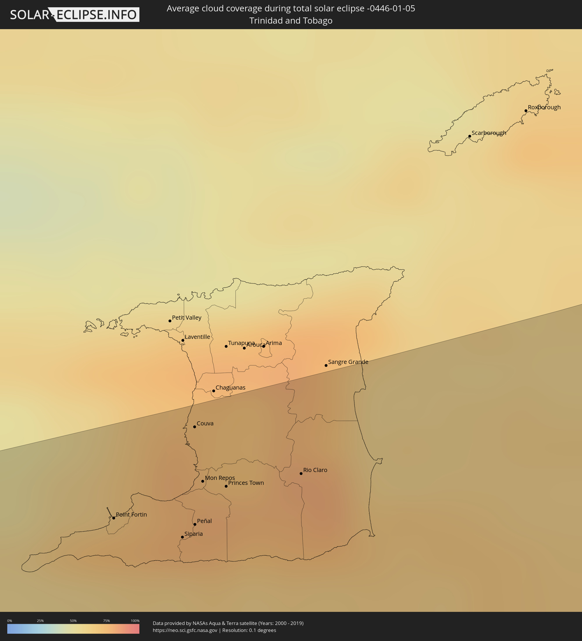 Trinidad und Tobago
 Portugal
 Spanien
Orte im Finsternispfad
Die nachfolgene Tabelle zeigt Städte und Orte mit mehr als 5.000 Einwohnern, die sich im Finsternispfad befinden. Städte mit mehr als 100.000 Einwohnern sind dick gekennzeichnet. Mit einem Klick auf den Ort öffnet sich eine Detailkarte die die Lage des jeweiligen Ortes zusammen mit dem Verlauf der zentralen Finsternis präsentiert.
| Ort | Typ | Dauer der Verfinsterung | Ortszeit bei maximaler Verfinsterung | Entfernung zur Zentrallinie | Ø Bewölkung |
|
Coahuayana Viejo, Michoacán
|
total | - | 07:42:33 UTC-06:36 | 61 km | 31% |
|
Buenos Aires, Michoacán
|
total | - | 07:43:01 UTC-06:36 | 47 km | 41% |
|
Ciudad Lázaro Cárdenas, Michoacán
|
total | - | 07:43:02 UTC-06:36 | 44 km | 40% |
|
San José Ixtapa (Barrio Viejo), Guerrero
|
total | - | 07:43:18 UTC-06:36 | 43 km | 36% |
|
Ixtapa-Zihuatanejo, Guerrero
|
total | - | 07:43:19 UTC-06:36 | 40 km | 37% |
|
Petatlán, Guerrero
|
total | - | 07:43:28 UTC-06:36 | 41 km | 35% |
|
El Súchil, Guerrero
|
total | - | 07:43:45 UTC-06:36 | 36 km | 32% |
|
Técpan de Galeana, Guerrero
|
total | - | 07:43:46 UTC-06:36 | 36 km | 32% |
|
San Jerónimo de Juárez, Guerrero
|
total | - | 07:43:50 UTC-06:36 | 34 km | 34% |
|
Atoyac de Álvarez, Guerrero
|
total | - | 07:43:55 UTC-06:36 | 43 km | 33% |
|
Coyuca de Benítez, Guerrero
|
total | - | 07:44:04 UTC-06:36 | 37 km | 31% |
|
Acapulco de Juárez, Guerrero
|
total | - | 07:44:08 UTC-06:36 | 31 km | 33% |
|
Xaltianguis, Guerrero
|
total | - | 07:44:26 UTC-06:36 | 62 km | 30% |
|
San Marcos, Guerrero
|
total | - | 07:44:32 UTC-06:36 | 45 km | 28% |
|
Cruz Grande, Guerrero
|
total | - | 07:44:43 UTC-06:36 | 49 km | 26% |
|
Copala, Guerrero
|
total | - | 07:44:46 UTC-06:36 | 43 km | 25% |
|
Marquelia, Guerrero
|
total | - | 07:44:54 UTC-06:36 | 47 km | 22% |
|
Cuajinicuilapa de Santa Maria, Guerrero
|
total | - | 07:45:12 UTC-06:36 | 53 km | 26% |
|
Pinotepa, Oaxaca
|
total | - | 07:45:27 UTC-06:36 | 54 km | 19% |
|
Jamiltepec, Oaxaca
|
total | - | 07:45:38 UTC-06:36 | 58 km | 22% |
|
Puerto Escondido, Oaxaca
|
total | - | 07:46:06 UTC-06:36 | 46 km | 21% |
|
Brisas de Zicatela, Oaxaca
|
total | - | 07:46:07 UTC-06:36 | 44 km | 22% |
|
San Pedro Pochutla, Oaxaca
|
total | - | 07:46:38 UTC-06:36 | 58 km | 23% |
|
Corinto, Chinandega
|
total | - | 08:48:14 UTC-05:45 | 70 km | 34% |
|
León, León
|
total | - | 08:48:41 UTC-05:45 | 75 km | 34% |
|
La Paz Centro, León
|
total | - | 08:48:58 UTC-05:45 | 72 km | 28% |
|
Nagarote, León
|
total | - | 08:49:06 UTC-05:45 | 67 km | 30% |
|
San Rafael del Sur, Managua
|
total | - | 08:49:05 UTC-05:45 | 27 km | 38% |
|
El Crucero, Managua
|
total | - | 08:49:22 UTC-05:45 | 47 km | 50% |
|
Managua, Managua
|
total | - | 08:49:33 UTC-05:45 | 64 km | 56% |
|
Diriamba, Carazo
|
total | - | 08:49:25 UTC-05:45 | 35 km | 47% |
|
Ticuantepe, Managua
|
total | - | 08:49:34 UTC-05:45 | 53 km | 62% |
|
San Marcos, Carazo
|
total | - | 08:49:30 UTC-05:45 | 41 km | 47% |
|
Masatepe, Masaya
|
total | - | 08:49:36 UTC-05:45 | 44 km | 53% |
|
Nindirí, Masaya
|
total | - | 08:49:42 UTC-05:45 | 54 km | 54% |
|
Tipitapa, Managua
|
total | - | 08:49:50 UTC-05:45 | 76 km | 55% |
|
Niquinohomo, Masaya
|
total | - | 08:49:41 UTC-05:45 | 45 km | 53% |
|
Masaya, Masaya
|
total | - | 08:49:43 UTC-05:45 | 52 km | 54% |
|
Nandaime, Granada
|
total | - | 08:49:40 UTC-05:45 | 30 km | 51% |
|
Diriomo, Granada
|
total | - | 08:49:44 UTC-05:45 | 43 km | 53% |
|
Granada, Granada
|
total | - | 08:49:56 UTC-05:45 | 52 km | 50% |
|
San Juan del Sur, Rivas
|
total | - | 08:49:43 UTC-05:45 | 17 km | 57% |
|
Rivas, Rivas
|
total | - | 08:49:53 UTC-05:45 | 4 km | 48% |
|
San Jorge, Rivas
|
total | - | 08:49:56 UTC-05:45 | 6 km | 46% |
|
Liberia, Guanacaste
|
total | - | 08:59:07 UTC-05:36 | 69 km | 45% |
|
San José, Alajuela
|
total | - | 08:59:48 UTC-05:36 | 26 km | 85% |
|
Tilarán, Guanacaste
|
total | - | 08:59:50 UTC-05:36 | 73 km | 57% |
|
San Carlos, Río San Juan
|
total | - | 08:51:32 UTC-05:45 | 3 km | 79% |
|
Nueva Guinea, Atlántico Sur
|
total | - | 08:52:24 UTC-05:45 | 73 km | 84% |
|
Quesada, Alajuela
|
total | - | 09:00:43 UTC-05:36 | 71 km | 84% |
|
Río Segundo, Alajuela
|
total | - | 09:00:57 UTC-05:36 | 76 km | 70% |
|
Guápiles, Limón
|
total | - | 09:01:49 UTC-05:36 | 64 km | 88% |
|
Guácimo, Limón
|
total | - | 09:02:00 UTC-05:36 | 61 km | 85% |
|
Pocora, Limón
|
total | - | 09:02:08 UTC-05:36 | 63 km | 82% |
|
Siquirres, Limón
|
total | - | 09:02:16 UTC-05:36 | 68 km | 84% |
|
Limón, Limón
|
total | - | 09:03:06 UTC-05:36 | 66 km | 76% |
|
Puerto Escondido, Colón
|
total | - | 09:25:09 UTC-05:19 | 75 km | 71% |
|
Colón, Colón
|
total | - | 09:25:38 UTC-05:19 | 54 km | 54% |
|
Cativá, Colón
|
total | - | 09:25:47 UTC-05:19 | 51 km | 56% |
|
Sabanitas, Colón
|
total | - | 09:25:49 UTC-05:19 | 53 km | 56% |
|
Puerto Pilón, Colón
|
total | - | 09:25:52 UTC-05:19 | 50 km | 56% |
|
Chilibre, Panamá
|
total | - | 09:26:07 UTC-05:19 | 69 km | 61% |
|
Alcalde Díaz, Panamá
|
total | - | 09:26:14 UTC-05:19 | 71 km | 60% |
|
La Cabima, Panamá
|
total | - | 09:26:17 UTC-05:19 | 71 km | 72% |
|
Las Cumbres, Panamá
|
total | - | 09:26:17 UTC-05:19 | 74 km | 72% |
|
San Miguelito, Panamá
|
total | - | 09:26:23 UTC-05:19 | 77 km | 72% |
|
Tocumen, Panamá
|
total | - | 09:26:36 UTC-05:19 | 70 km | 72% |
|
Pacora, Panamá
|
total | - | 09:26:47 UTC-05:19 | 69 km | 64% |
|
Chepo, Panamá
|
total | - | 09:27:15 UTC-05:19 | 55 km | 62% |
|
El Porvenir, Guna Yala
|
total | - | 09:27:46 UTC-05:19 | 10 km | 75% |
|
Montería, Córdoba
|
total | - | 09:57:41 UTC-04:56 | 41 km | 73% |
|
Lorica, Córdoba
|
total | - | 09:58:08 UTC-04:56 | 14 km | 55% |
|
Cereté, Córdoba
|
total | - | 09:57:59 UTC-04:56 | 24 km | 69% |
|
Planeta Rica, Córdoba
|
total | - | 09:58:13 UTC-04:56 | 73 km | 72% |
|
Tolú, Sucre
|
total | - | 09:58:51 UTC-04:56 | 49 km | 39% |
|
San Onofre, Sucre
|
total | - | 09:59:07 UTC-04:56 | 74 km | 45% |
|
Sahagún, Córdoba
|
total | - | 09:58:52 UTC-04:56 | 12 km | 67% |
|
Chinú, Córdoba
|
total | - | 09:59:04 UTC-04:56 | 6 km | 64% |
|
Sincelejo, Sucre
|
total | - | 09:59:10 UTC-04:56 | 28 km | 60% |
|
Sincé, Sucre
|
total | - | 09:59:45 UTC-04:56 | 25 km | 57% |
|
Ayapel, Córdoba
|
total | - | 09:59:15 UTC-04:56 | 78 km | 64% |
|
San Marcos, Sucre
|
total | - | 09:59:28 UTC-04:56 | 39 km | 49% |
|
El Carmen de Bolívar, Bolívar
|
total | - | 10:00:06 UTC-04:56 | 78 km | 50% |
|
San Benito Abad, Sucre
|
total | - | 09:59:52 UTC-04:56 | 8 km | 37% |
|
Magangué, Bolívar
|
total | - | 10:00:43 UTC-04:56 | 30 km | 41% |
|
Sucre, Sucre
|
total | - | 10:00:33 UTC-04:56 | 17 km | 49% |
|
Mompós, Bolívar
|
total | - | 10:01:32 UTC-04:56 | 34 km | 34% |
|
El Banco, Magdalena
|
total | - | 10:02:32 UTC-04:56 | 13 km | 32% |
|
Morales, Bolívar
|
total | - | 10:02:23 UTC-04:56 | 66 km | 41% |
|
Aguachica, Cesar
|
total | - | 10:03:02 UTC-04:56 | 60 km | 61% |
|
Curumaní, Cesar
|
total | - | 10:03:45 UTC-04:56 | 40 km | 46% |
|
Ocaña, Norte de Santander
|
total | - | 10:03:40 UTC-04:56 | 65 km | 66% |
|
La Jagua de Ibirico, Cesar
|
total | - | 10:04:31 UTC-04:56 | 82 km | 39% |
|
San Juan de Colón, Táchira
|
total | - | 10:34:59 UTC-04:27 | 79 km | 67% |
|
La Fría, Táchira
|
total | - | 10:35:08 UTC-04:27 | 59 km | 81% |
|
San Carlos del Zulia, Zulia
|
total | - | 10:36:30 UTC-04:27 | 31 km | 85% |
|
El Vigía, Mérida
|
total | - | 10:36:57 UTC-04:27 | 11 km | 82% |
|
Ejido, Mérida
|
total | - | 10:38:01 UTC-04:27 | 16 km | 38% |
|
Mérida, Mérida
|
total | - | 10:38:16 UTC-04:27 | 11 km | 47% |
|
Mucumpiz, Mérida
|
total | - | 10:38:14 UTC-04:27 | 30 km | 69% |
|
Valera, Trujillo
|
total | - | 10:40:15 UTC-04:27 | 72 km | 68% |
|
Trujillo, Trujillo
|
total | - | 10:40:44 UTC-04:27 | 78 km | 60% |
|
Barinitas, Barinas
|
total | - | 10:40:25 UTC-04:27 | 10 km | 68% |
|
Alto Barinas, Barinas
|
total | - | 10:40:49 UTC-04:27 | 8 km | 69% |
|
Barinas, Barinas
|
total | - | 10:40:53 UTC-04:27 | 5 km | 69% |
|
Guanare, Portuguesa
|
total | - | 10:42:27 UTC-04:27 | 42 km | 68% |
|
Villa Bruzual, Portuguesa
|
total | - | 10:44:23 UTC-04:27 | 74 km | 64% |
|
Calabozo, Guárico
|
total | - | 10:48:57 UTC-04:27 | 21 km | 57% |
|
Valle de La Pascua, Guárico
|
total | - | 10:53:19 UTC-04:27 | 41 km | 65% |
|
Zaraza, Guárico
|
total | - | 10:55:26 UTC-04:27 | 47 km | 68% |
|
Anaco, Anzoátegui
|
total | - | 10:58:03 UTC-04:27 | 44 km | 73% |
|
Cantaura, Anzoátegui
|
total | - | 10:58:17 UTC-04:27 | 27 km | 71% |
|
El Tigre, Anzoátegui
|
total | - | 10:58:19 UTC-04:27 | 21 km | 78% |
|
San José de Guanipa, Anzoátegui
|
total | - | 10:58:33 UTC-04:27 | 22 km | 78% |
|
Maturín, Monagas
|
total | - | 11:02:09 UTC-04:27 | 54 km | 79% |
|
Tucupita, Delta Amacuro
|
total | - | 11:05:03 UTC-04:27 | 46 km | 73% |
|
Point Fortin, Point Fortin
|
total | - | 11:28:38 UTC-04:06 | 67 km | 73% |
|
Siparia, Siparia
|
total | - | 11:29:09 UTC-04:06 | 57 km | 64% |
|
Couva, Couva-Tabaquite-Talparo
|
total | - | 11:29:28 UTC-04:06 | 88 km | 77% |
|
Peñal, Penal/Debe
|
total | - | 11:29:17 UTC-04:06 | 60 km | 76% |
|
San Fernando, City of San Fernando
|
total | - | 11:29:22 UTC-04:06 | 73 km | 76% |
|
Marabella, City of San Fernando
|
total | - | 11:29:27 UTC-04:06 | 75 km | 78% |
|
Mon Repos, City of San Fernando
|
total | - | 11:29:26 UTC-04:06 | 72 km | 78% |
|
Princes Town, Princes Town
|
total | - | 11:29:36 UTC-04:06 | 69 km | 78% |
|
Rio Claro, Mayaro
|
total | - | 11:30:14 UTC-04:06 | 67 km | 77% |
|
Mafra, Lisbon
|
total | - | 16:30:32 UTC-00:36 | 49 km | 65% |
|
Cacém, Lisbon
|
total | - | 16:30:39 UTC-00:36 | 32 km | 67% |
|
Lisbon, Lisbon
|
total | - | 16:30:45 UTC-00:36 | 19 km | 66% |
|
Sesimbra, Setúbal
|
total | - | 16:30:57 UTC-00:36 | 8 km | 61% |
|
Póvoa de Santa Iria, Lisbon
|
total | - | 16:30:41 UTC-00:36 | 30 km | 67% |
|
Alenquer, Lisbon
|
total | - | 16:30:35 UTC-00:36 | 45 km | 68% |
|
Setúbal, Setúbal
|
total | - | 16:30:59 UTC-00:36 | 10 km | 62% |
|
Samora Correia, Santarém
|
total | - | 16:30:43 UTC-00:36 | 28 km | 63% |
|
Santarém, Santarém
|
total | - | 16:30:36 UTC-00:36 | 47 km | 65% |
|
Grândola, Setúbal
|
total | - | 16:31:20 UTC-00:36 | 58 km | 60% |
|
Coruche, Santarém
|
total | - | 16:30:51 UTC-00:36 | 14 km | 59% |
|
Alcácer do Sal, Setúbal
|
total | - | 16:31:14 UTC-00:36 | 42 km | 62% |
|
Vendas Novas, Évora
|
total | - | 16:31:04 UTC-00:36 | 15 km | 61% |
|
Santo André, Portalegre
|
total | - | 16:30:54 UTC-00:36 | 11 km | 59% |
|
Montemor-o-Novo, Évora
|
total | - | 16:31:11 UTC-00:36 | 29 km | 60% |
|
Abrantes, Santarém
|
total | - | 16:30:38 UTC-00:36 | 47 km | 59% |
|
Ponte de Sôr, Portalegre
|
total | - | 16:30:51 UTC-00:36 | 18 km | 58% |
|
Évora, Évora
|
total | - | 16:31:21 UTC-00:36 | 51 km | 63% |
|
Vale da Amoreira, Portalegre
|
total | - | 16:31:06 UTC-00:36 | 13 km | 62% |
|
Estremoz, Évora
|
total | - | 16:31:17 UTC-00:36 | 39 km | 58% |
|
Castelo Branco, Castelo Branco
|
total | - | 16:30:40 UTC-00:36 | 49 km | 56% |
|
Portalegre, Portalegre
|
total | - | 16:31:03 UTC-00:36 | 4 km | 57% |
|
Valencia de Alcántara, Extremadura
|
total | - | 17:07:47 UTC+00:00 | 1 km | 56% |
|
Elvas, Portalegre
|
total | - | 16:31:25 UTC-00:36 | 55 km | 63% |
|
Alburquerque, Extremadura
|
total | - | 17:08:00 UTC+00:00 | 30 km | 60% |
|
Moraleja, Extremadura
|
total | - | 17:07:33 UTC+00:00 | 35 km | 55% |
|
Arroyo de la Luz, Extremadura
|
total | - | 17:07:58 UTC+00:00 | 24 km | 61% |
|
Coria, Extremadura
|
total | - | 17:07:39 UTC+00:00 | 22 km | 56% |
|
Cáceres, Extremadura
|
total | - | 17:08:03 UTC+00:00 | 34 km | 63% |
|
Montehermoso, Extremadura
|
total | - | 17:07:38 UTC+00:00 | 23 km | 58% |
|
Plasencia, Extremadura
|
total | - | 17:07:46 UTC+00:00 | 8 km | 62% |
|
Trujillo, Extremadura
|
total | - | 17:08:14 UTC+00:00 | 57 km | 62% |