Hybride Sonnenfinsternis vom 05.01.-0465
| Wochentag: | Freitag |
| Maximale Dauer der Verfinsterung: | 01m20s |
| Maximale Breite des Finsternispfades: | 49 km |
| Saroszyklus: | 53 |
| Bedeckungsgrad: | 100% |
| Magnitude: | 1.0141 |
| Gamma: | -0.1117 |
Wo kann man die Sonnenfinsternis vom 05.01.-0465 sehen?
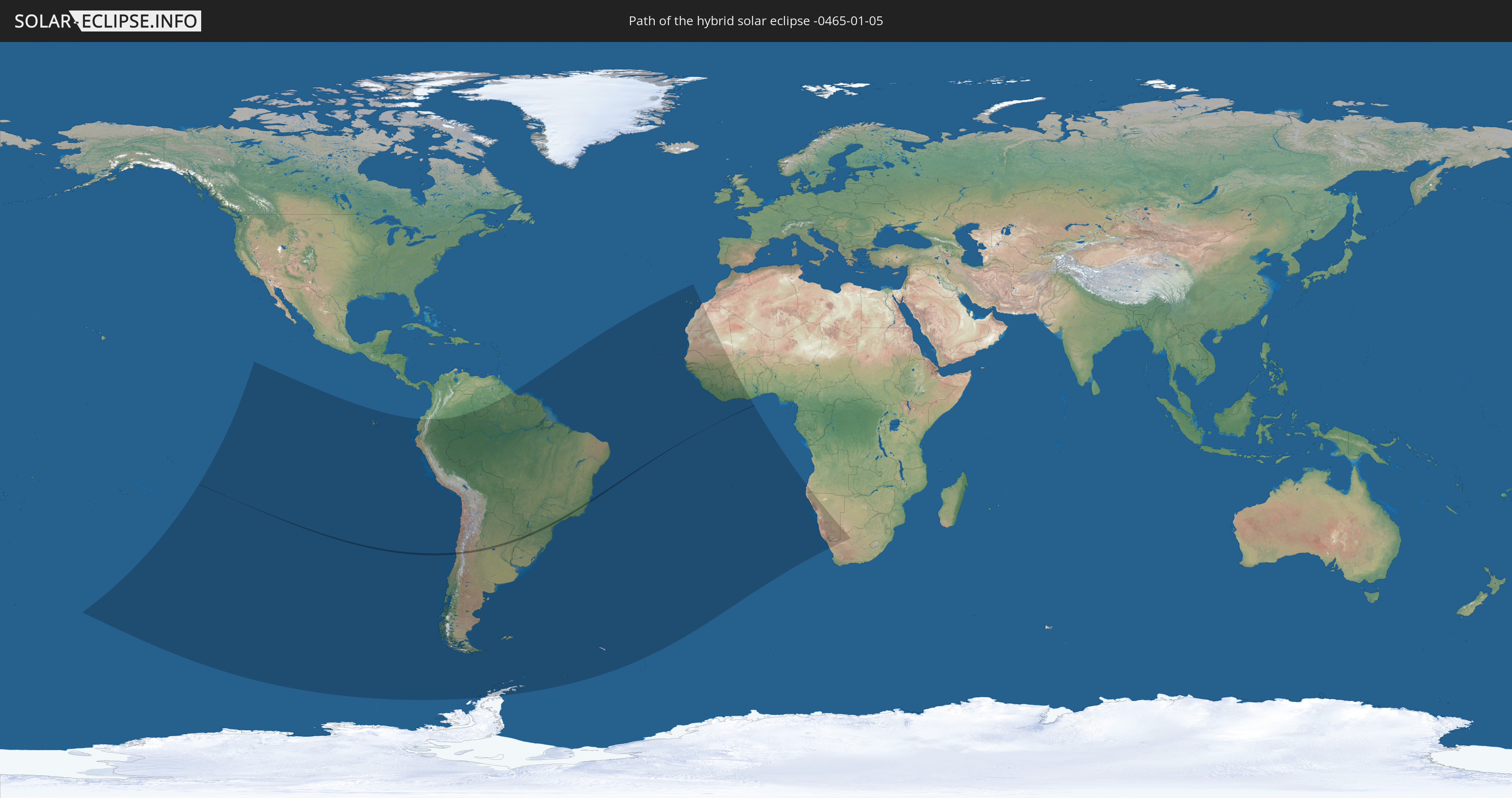
Die Sonnenfinsternis am 05.01.-0465 kann man in 38 Ländern als partielle Sonnenfinsternis beobachten.
Der Finsternispfad verläuft durch 3 Länder. Nur in diesen Ländern ist sie als hybride Sonnenfinsternis zu sehen.
In den folgenden Ländern ist die Sonnenfinsternis hybrid zu sehen
 Chile
Chile
 Brasilien
 Argentinien
In den folgenden Ländern ist die Sonnenfinsternis partiell zu sehen
 Antarktika
 Französisch-Polynesien
 Pitcairninseln
 Chile
Chile
 Ecuador
 Kolumbien
 Peru
Peru
 Brasilien
 Argentinien
 Venezuela
 Bolivien
 Paraguay
 Falklandinseln
 Guyana
 Uruguay
 Suriname
 Französisch-Guayana
 Südgeorgien und die Südlichen Sandwichinseln
 Portugal
 Kap Verde
 Spanien
 Senegal
 Mauretanien
 Gambia
 Guinea-Bissau
 Guinea
 St. Helena
 Sierra Leone
 Marokko
 Mali
Mali
 Liberia
 Elfenbeinküste
 Burkina Faso
 Ghana
Ghana
 Angola
 Namibia
 Südafrika
 Botswana
Wie wird das Wetter während der hybriden Sonnenfinsternis am 05.01.-0465?
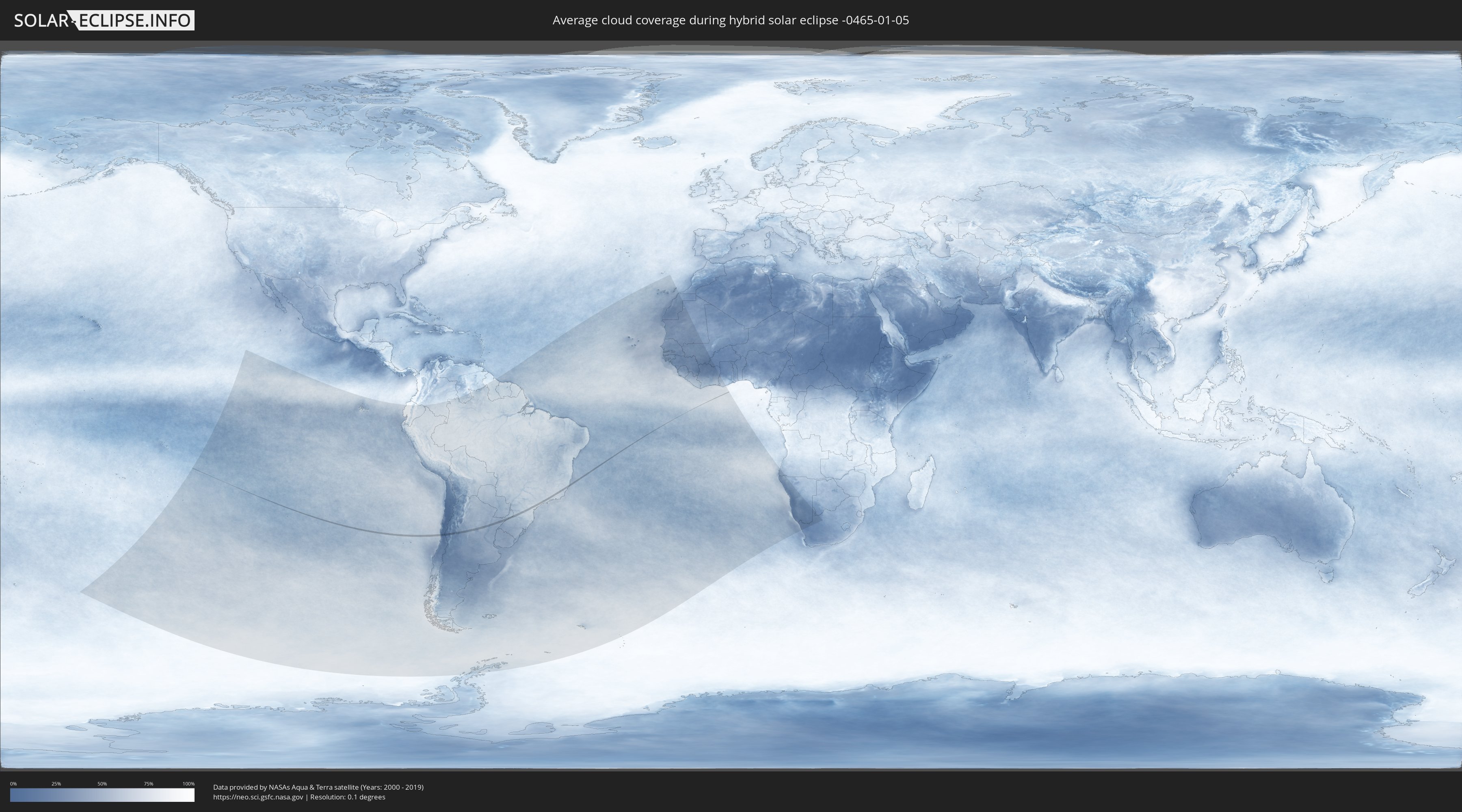
Wo ist der beste Ort, um die hybride Sonnenfinsternis vom 05.01.-0465 zu beobachten?
Die folgenden Karten zeigen die durchschnittliche Bewölkung für den Tag, an dem die hybride Sonnenfinsternis
stattfindet. Mit Hilfe der Karten lässt sich der Ort entlang des Finsternispfades eingrenzen,
der die besten Aussichen auf einen klaren wolkenfreien Himmel bietet.
Trotzdem muss man immer lokale Gegenenheiten beachten und sollte sich genau über das Wetter an seinem
gewählten Beobachtungsort informieren.
Die Daten stammen von den beiden NASA-Satelliten
AQUA und TERRA
und wurden über einen Zeitraum von 19 Jahren (2000 - 2019) gemittelt.

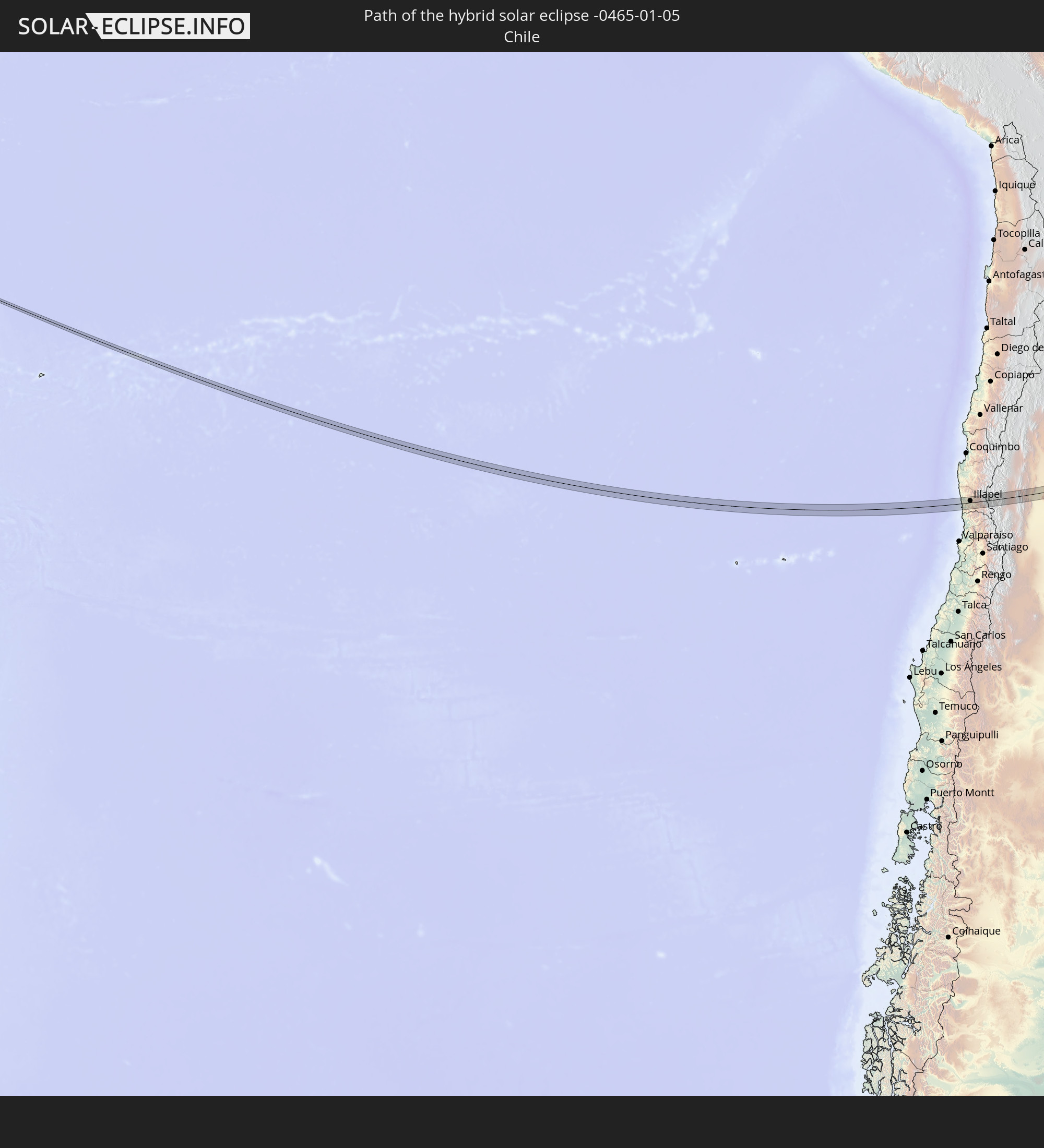
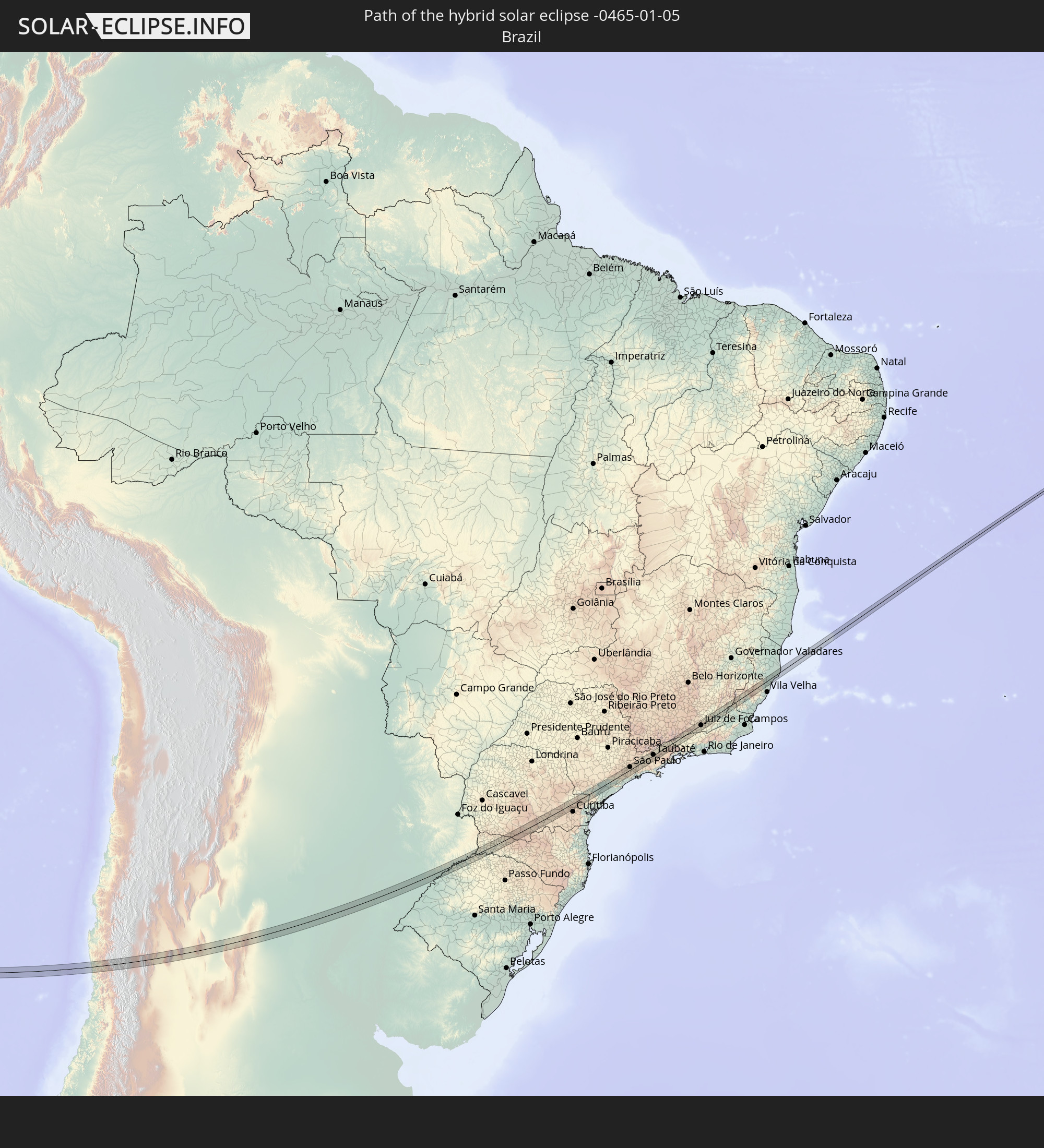
Detaillierte Länderkarten
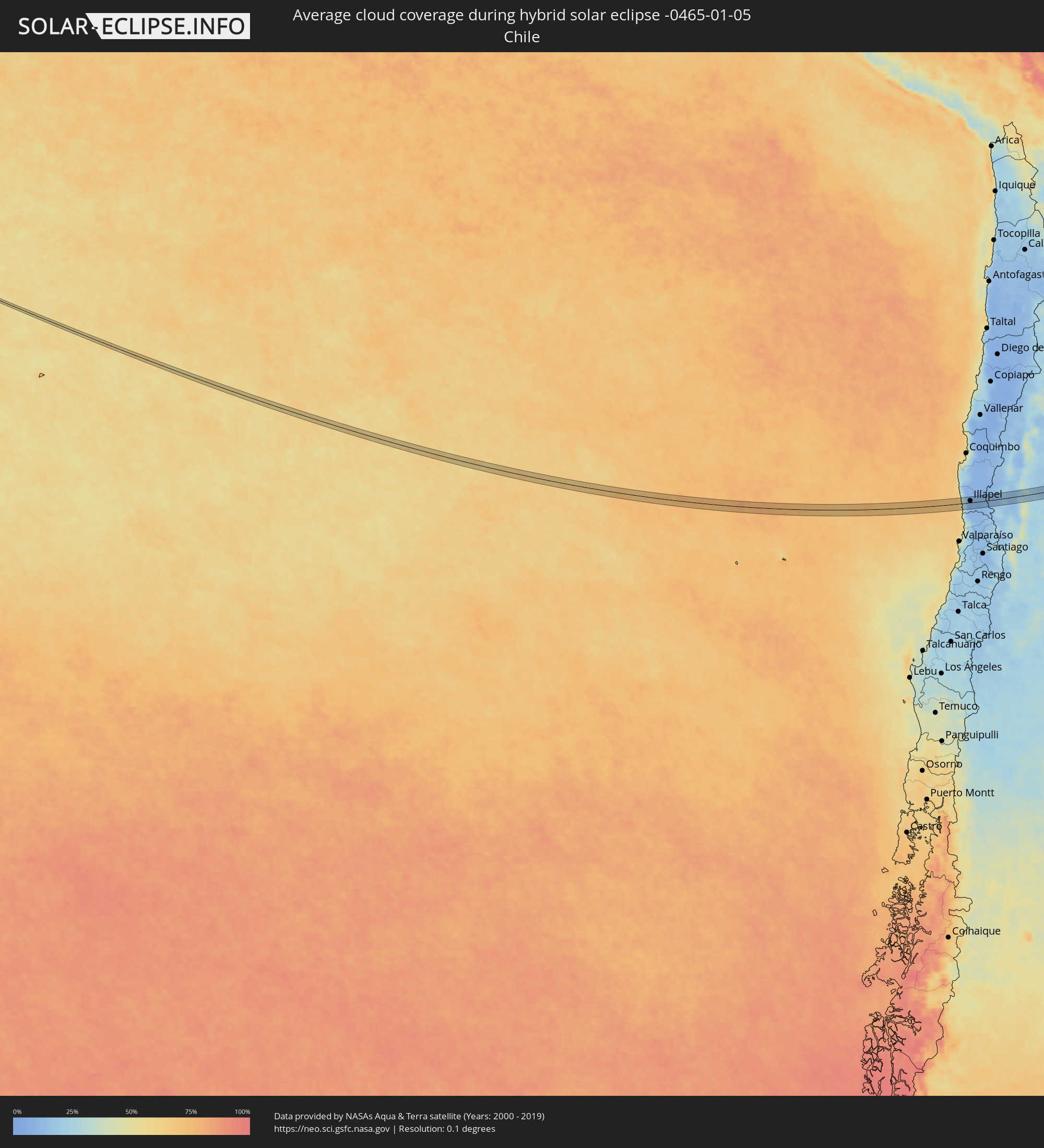 Chile
Chile
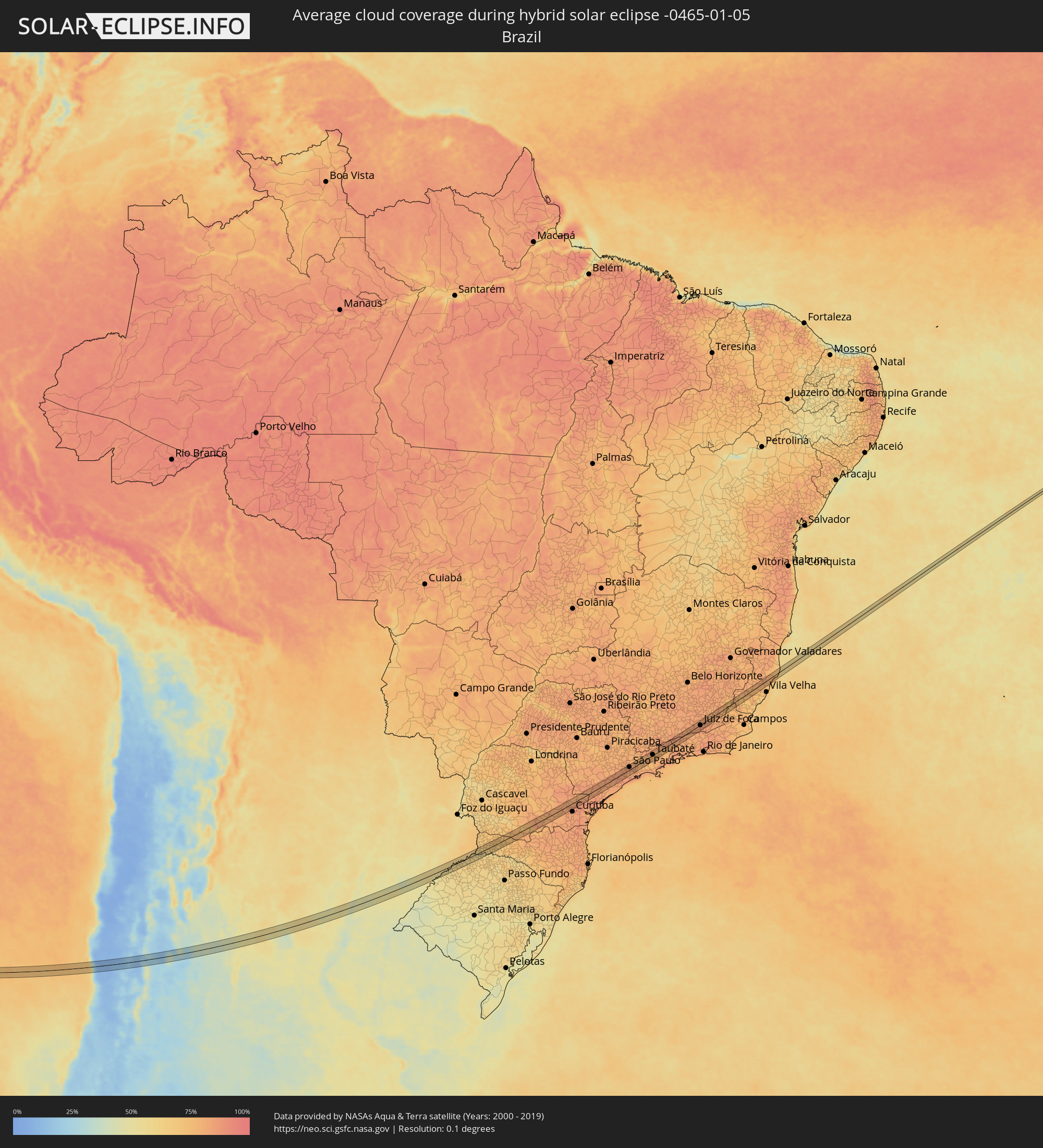 Brasilien
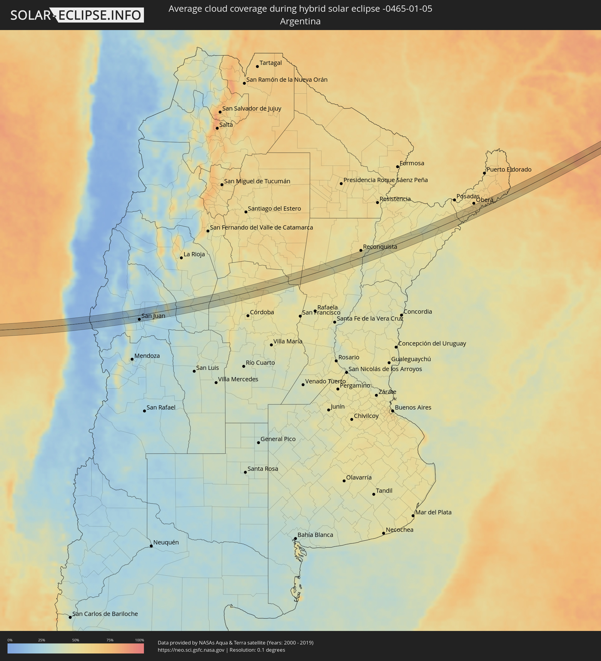 Argentinien
Orte im Finsternispfad
Die nachfolgene Tabelle zeigt Städte und Orte mit mehr als 5.000 Einwohnern, die sich im Finsternispfad befinden. Städte mit mehr als 100.000 Einwohnern sind dick gekennzeichnet. Mit einem Klick auf den Ort öffnet sich eine Detailkarte die die Lage des jeweiligen Ortes zusammen mit dem Verlauf der zentralen Finsternis präsentiert.
| Ort | Typ | Dauer der Verfinsterung | Ortszeit bei maximaler Verfinsterung | Entfernung zur Zentrallinie | Ø Bewölkung |
|
Illapel, Coquimbo
|
total | - | 11:09:34 UTC-04:42 | 6 km | 10% |
|
Salamanca, Coquimbo
|
total | - | 11:10:03 UTC-04:42 | 12 km | 11% |
|
Calingasta, San Juan Province
|
total | - | 11:40:03 UTC-04:16 | 18 km | 13% |
|
Villa Paula de Sarmiento, San Juan Province
|
total | - | 11:42:11 UTC-04:16 | 12 km | 27% |
|
San Juan, San Juan Province
|
total | - | 11:42:10 UTC-04:16 | 17 km | 27% |
|
Chimbas, San Juan Province
|
total | - | 11:42:12 UTC-04:16 | 11 km | 27% |
|
Albardón, San Juan Province
|
total | - | 11:42:14 UTC-04:16 | 6 km | 23% |
|
San Martín, San Juan Province
|
total | - | 11:42:18 UTC-04:16 | 6 km | 23% |
|
Santa Lucía, San Juan Province
|
total | - | 11:42:16 UTC-04:16 | 18 km | 27% |
|
Villa de Soto, Cordoba Province
|
total | - | 11:51:32 UTC-04:16 | 9 km | 44% |
|
Cruz del Eje, Cordoba Province
|
total | - | 11:52:07 UTC-04:16 | 0 km | 47% |
|
Capilla del Monte, Cordoba Province
|
total | - | 11:52:44 UTC-04:16 | 21 km | 50% |
|
Deán Funes, Cordoba Province
|
total | - | 11:53:30 UTC-04:16 | 23 km | 50% |
|
Ceres, Santa Fe Province
|
total | - | 12:00:07 UTC-04:16 | 18 km | 55% |
|
Vera, Santa Fe Province
|
total | - | 12:04:55 UTC-04:16 | 10 km | 50% |
|
Malabrigo, Santa Fe Province
|
total | - | 12:05:39 UTC-04:16 | 14 km | 53% |
|
Goya, Corrientes Province
|
total | - | 12:07:38 UTC-04:16 | 13 km | 46% |
|
Santa Lucía, Corrientes Province
|
total | - | 12:08:13 UTC-04:16 | 23 km | 47% |
|
Gobernador Ingeniero Valentín Virasoro, Corrientes Province
|
total | - | 12:16:54 UTC-04:16 | 8 km | 57% |
|
Concepción de la Sierra, Misiones Province
|
total | - | 12:18:13 UTC-04:16 | 6 km | 52% |
|
Panambí, Misiones Province
|
total | - | 12:20:00 UTC-04:16 | 4 km | 57% |
|
Alba Posse, Misiones Province
|
total | - | 12:20:45 UTC-04:16 | 2 km | 61% |
|
Colonia Aurora, Misiones Province
|
total | - | 12:21:15 UTC-04:16 | 5 km | 61% |
|
Horizontina, Rio Grande do Sul
|
total | - | 13:31:54 UTC-03:06 | 19 km | 63% |
|
El Soberbio, Misiones Province
|
total | - | 12:22:15 UTC-04:16 | 9 km | 58% |
|
Três Passos, Rio Grande do Sul
|
total | - | 13:33:00 UTC-03:06 | 18 km | 64% |
|
Clevelândia, Paraná
|
total | - | 13:37:51 UTC-03:06 | 23 km | 71% |
|
Palmas, Paraná
|
total | - | 13:38:49 UTC-03:06 | 7 km | 76% |
|
Palmeira, Paraná
|
total | - | 13:44:45 UTC-03:06 | 2 km | 80% |
|
Itaperuçu, Paraná
|
total | - | 13:46:29 UTC-03:06 | 10 km | 87% |
|
Rio Branco do Sul, Paraná
|
total | - | 13:46:36 UTC-03:06 | 9 km | 87% |
|
Almirante Tamandaré, Paraná
|
total | - | 13:46:25 UTC-03:06 | 22 km | 85% |
|
Registro, São Paulo
|
total | - | 13:50:45 UTC-03:06 | 16 km | 80% |
|
Juquiá, São Paulo
|
total | - | 13:51:26 UTC-03:06 | 10 km | 82% |
|
Miracatu, São Paulo
|
total | - | 13:51:51 UTC-03:06 | 16 km | 82% |
|
Juquitiba, São Paulo
|
total | - | 13:53:11 UTC-03:06 | 3 km | 84% |
|
São Lourenço da Serra, São Paulo
|
total | - | 13:53:33 UTC-03:06 | 2 km | 84% |
|
Cotia, São Paulo
|
total | - | 13:53:59 UTC-03:06 | 20 km | 82% |
|
Embu, São Paulo
|
total | - | 13:54:03 UTC-03:06 | 13 km | 82% |
|
Itapecerica da Serra, São Paulo
|
total | - | 13:53:57 UTC-03:06 | 6 km | 82% |
|
Embu Guaçu, São Paulo
|
total | - | 13:53:51 UTC-03:06 | 7 km | 84% |
|
Taboão da Serra, São Paulo
|
total | - | 13:54:12 UTC-03:06 | 12 km | 82% |
|
Osasco, São Paulo
|
total | - | 13:54:21 UTC-03:06 | 21 km | 83% |
|
São Paulo, São Paulo
|
total | - | 13:54:38 UTC-03:06 | 11 km | 84% |
|
São Bernardo do Campo, São Paulo
|
total | - | 13:54:33 UTC-03:06 | 7 km | 81% |
|
São Caetano do Sul, São Paulo
|
total | - | 13:54:42 UTC-03:06 | 1 km | 82% |
|
Ribeirão Pires, São Paulo
|
total | - | 13:54:50 UTC-03:06 | 16 km | 82% |
|
Rio Grande da Serra, São Paulo
|
total | - | 13:54:48 UTC-03:06 | 20 km | 82% |
|
Ferraz de Vasconcelos, São Paulo
|
total | - | 13:55:11 UTC-03:06 | 3 km | 82% |
|
Itaquaquecetuba, São Paulo
|
total | - | 13:55:18 UTC-03:06 | 1 km | 81% |
|
Poá, São Paulo
|
total | - | 13:55:15 UTC-03:06 | 3 km | 81% |
|
Arujá, São Paulo
|
total | - | 13:55:30 UTC-03:06 | 8 km | 80% |
|
Suzano, São Paulo
|
total | - | 13:55:18 UTC-03:06 | 6 km | 81% |
|
Santa Isabel, São Paulo
|
total | - | 13:55:49 UTC-03:06 | 11 km | 77% |
|
Mogi das Cruzes, São Paulo
|
total | - | 13:55:34 UTC-03:06 | 11 km | 79% |
|
Guararema, São Paulo
|
total | - | 13:56:02 UTC-03:06 | 9 km | 78% |
|
Jacareí, São Paulo
|
total | - | 13:56:20 UTC-03:06 | 2 km | 77% |
|
São José dos Campos, São Paulo
|
total | - | 13:56:41 UTC-03:06 | 6 km | 80% |
|
Caçapava, São Paulo
|
total | - | 13:57:10 UTC-03:06 | 3 km | 78% |
|
Taubaté, São Paulo
|
total | - | 13:57:34 UTC-03:06 | 2 km | 78% |
|
Tremembé, São Paulo
|
total | - | 13:57:41 UTC-03:06 | 8 km | 76% |
|
Pindamonhangaba, São Paulo
|
total | - | 13:57:55 UTC-03:06 | 7 km | 77% |
|
Aparecida, São Paulo
|
total | - | 13:58:28 UTC-03:06 | 1 km | 76% |
|
Guaratinguetá, São Paulo
|
total | - | 13:58:36 UTC-03:06 | 2 km | 76% |
|
Piquete, São Paulo
|
total | - | 13:58:57 UTC-03:06 | 20 km | 80% |
|
Lorena, São Paulo
|
total | - | 13:58:51 UTC-03:06 | 6 km | 76% |
|
Cruzeiro, São Paulo
|
total | - | 13:59:24 UTC-03:06 | 13 km | 76% |
|
Itatiaia, Rio de Janeiro
|
total | - | 14:00:17 UTC-03:06 | 2 km | 76% |
|
Resende, Rio de Janeiro
|
total | - | 14:00:33 UTC-03:06 | 6 km | 78% |
|
Porto Real, Rio de Janeiro
|
total | - | 14:00:55 UTC-03:06 | 10 km | 79% |
|
Quatis, Rio de Janeiro
|
total | - | 14:00:59 UTC-03:06 | 11 km | 79% |
|
Lima Duarte, Minas Gerais
|
total | - | 14:02:44 UTC-03:06 | 16 km | 82% |
|
Juiz de Fora, Minas Gerais
|
total | - | 14:03:39 UTC-03:06 | 2 km | 86% |
|
Matias Barbosa, Minas Gerais
|
total | - | 14:03:33 UTC-03:06 | 13 km | 85% |
|
Bicas, Minas Gerais
|
total | - | 14:04:14 UTC-03:06 | 15 km | 83% |
|
São João Nepomuceno, Minas Gerais
|
total | - | 14:04:37 UTC-03:06 | 0 km | 80% |
|
Astolfo Dutra, Minas Gerais
|
total | - | 14:05:14 UTC-03:06 | 12 km | 80% |
|
Cataguases, Minas Gerais
|
total | - | 14:05:24 UTC-03:06 | 4 km | 79% |
|
Leopoldina, Minas Gerais
|
total | - | 14:05:16 UTC-03:06 | 20 km | 80% |
|
Muriaé, Minas Gerais
|
total | - | 14:06:23 UTC-03:06 | 1 km | 77% |
|
Porciúncula, Rio de Janeiro
|
total | - | 14:07:12 UTC-03:06 | 2 km | 74% |
|
Carangola, Minas Gerais
|
total | - | 14:07:35 UTC-03:06 | 19 km | 71% |
|
Natividade, Rio de Janeiro
|
total | - | 14:07:12 UTC-03:06 | 13 km | 74% |
|
Espera Feliz, Minas Gerais
|
total | - | 14:07:56 UTC-03:06 | 19 km | 76% |
|
Guaçuí, Espírito Santo
|
total | - | 14:08:07 UTC-03:06 | 5 km | 76% |
|
Alegre, Espírito Santo
|
total | - | 14:08:23 UTC-03:06 | 13 km | 73% |
|
Castelo, Espírito Santo
|
total | - | 14:09:13 UTC-03:06 | 18 km | 71% |
|
Santa Teresa, Espírito Santo
|
total | - | 14:11:13 UTC-03:06 | 9 km | 79% |
|
Fundão, Espírito Santo
|
total | - | 14:11:32 UTC-03:06 | 2 km | 75% |
|
João Neiva, Espírito Santo
|
total | - | 14:11:50 UTC-03:06 | 13 km | 78% |
|
Aracruz, Espírito Santo
|
total | - | 14:11:55 UTC-03:06 | 1 km | 77% |