Totale Sonnenfinsternis vom 09.05.-0593
| Wochentag: | Donnerstag |
| Maximale Dauer der Verfinsterung: | 03m45s |
| Maximale Breite des Finsternispfades: | 487 km |
| Saroszyklus: | 38 |
| Bedeckungsgrad: | 100% |
| Magnitude: | 1.0653 |
| Gamma: | 0.8961 |
Wo kann man die Sonnenfinsternis vom 09.05.-0593 sehen?

Die Sonnenfinsternis am 09.05.-0593 kann man in 93 Ländern als partielle Sonnenfinsternis beobachten.
Der Finsternispfad verläuft durch 6 Länder. Nur in diesen Ländern ist sie als totale Sonnenfinsternis zu sehen.
In den folgenden Ländern ist die Sonnenfinsternis total zu sehen
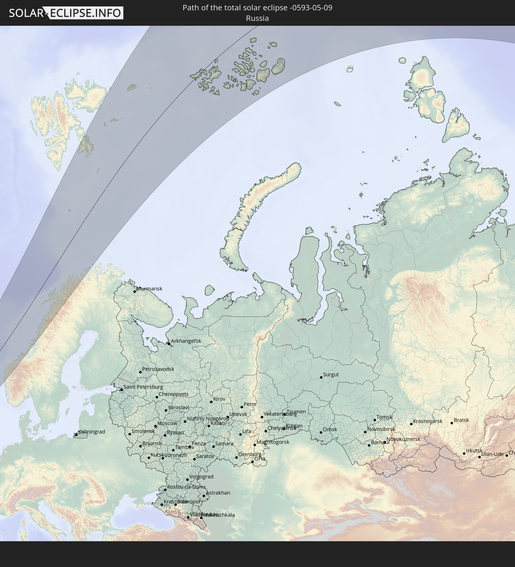 Russland
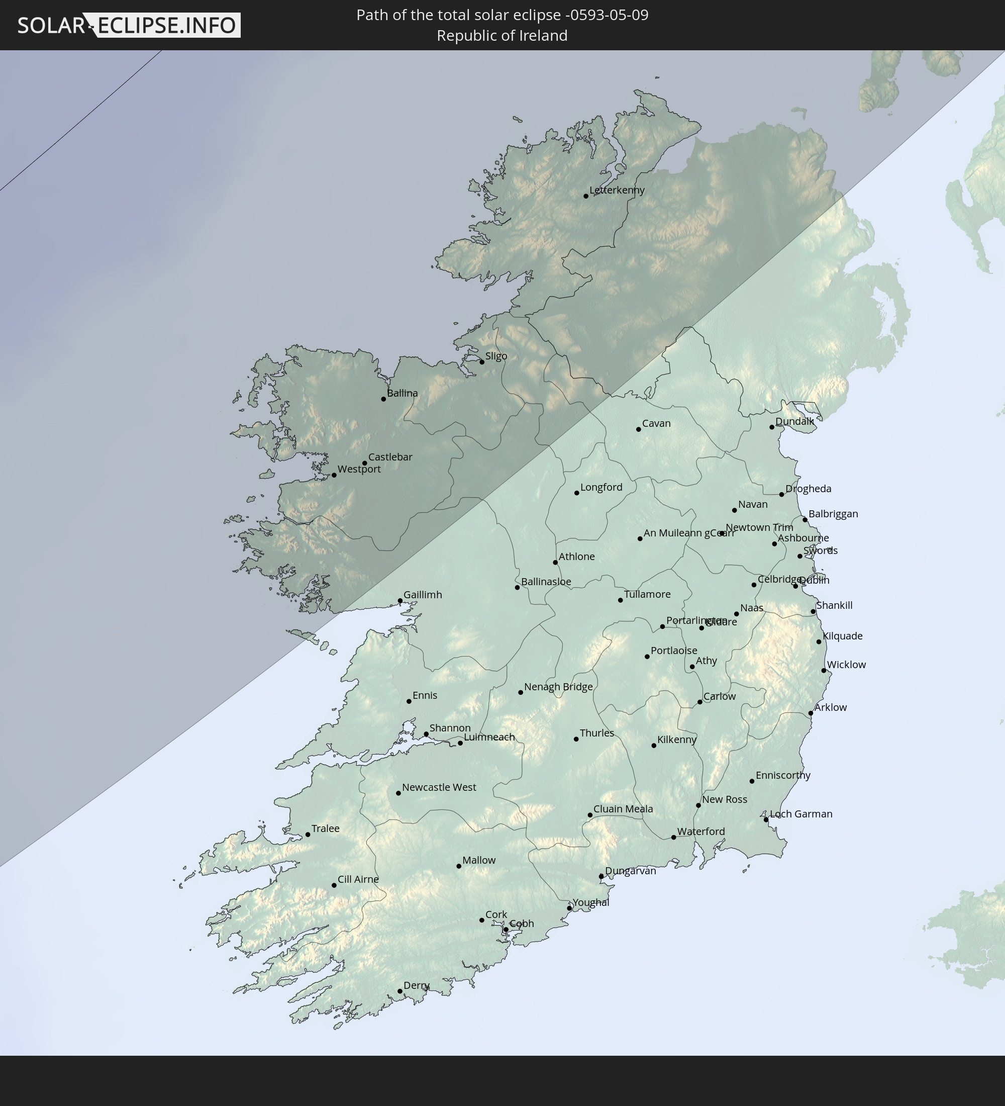 Irland
 Spitzbergen
 Vereinigtes Königreich
 Norwegen
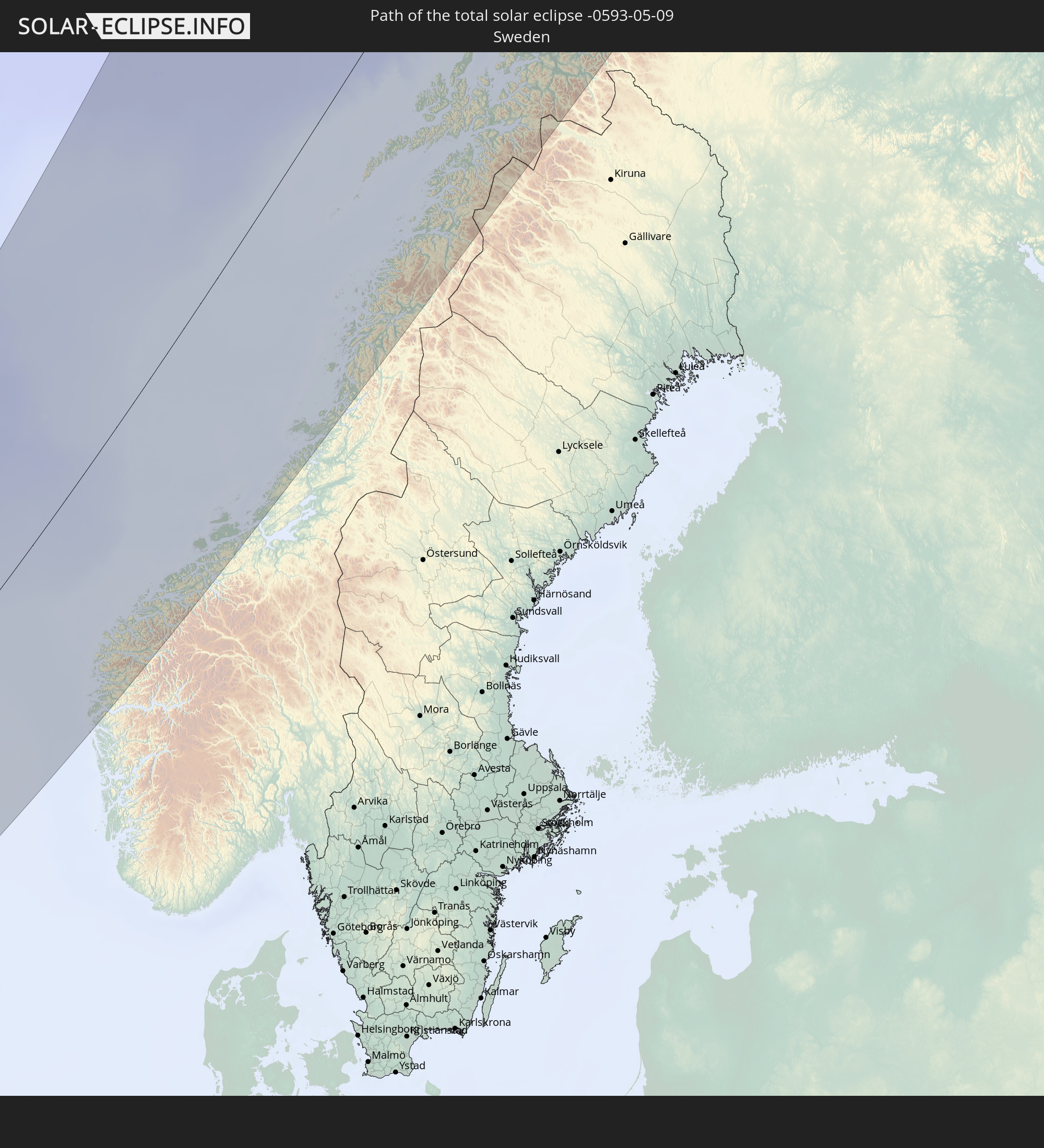 Schweden
In den folgenden Ländern ist die Sonnenfinsternis partiell zu sehen
 Russland
 Kanada
 Grönland
 Portugal
 Island
 Spanien
 Mauretanien
 Marokko
 Mali
Mali
 Irland
 Spitzbergen
 Algerien
 Vereinigtes Königreich
 Färöer
 Burkina Faso
 Gibraltar
 Frankreich
 Isle of Man
 Guernsey
 Jersey
 Togo
Togo
 Niger
Niger
 Benin
Benin
 Andorra
 Belgien
 Nigeria
 Niederlande
 Norwegen
 Luxemburg
 Deutschland
 Schweiz
 Italien
 Monaco
 Tunesien
 Dänemark
 Kamerun
 Libyen
 Liechtenstein
 Österreich
 Schweden
 Tschechien
 San Marino
 Vatikanstadt
 Slowenien
 Tschad
 Kroatien
 Polen
Polen
 Malta
Malta
 Bosnien und Herzegowina
 Ungarn
 Slowakei
 Montenegro
 Serbien
 Albanien
 Åland Islands
 Griechenland
 Rumänien
 Mazedonien
 Finnland
 Litauen
 Lettland
 Estland
 Sudan
Sudan
 Ukraine
 Bulgarien
 Weißrussland
 Ägypten
 Türkei
 Moldawien
 Republik Zypern
 Staat Palästina
 Israel
 Saudi-Arabien
 Jordanien
 Libanon
 Syrien
 Irak
Irak
 Georgien
 Armenien
 Iran
Iran
 Aserbaidschan
 Kasachstan
 Kuwait
 Turkmenistan
 Usbekistan
 Afghanistan
 Tadschikistan
 Kirgisistan
 Volksrepublik China
 Mongolei
 Japan
Japan
 Nordkorea
 Südkorea
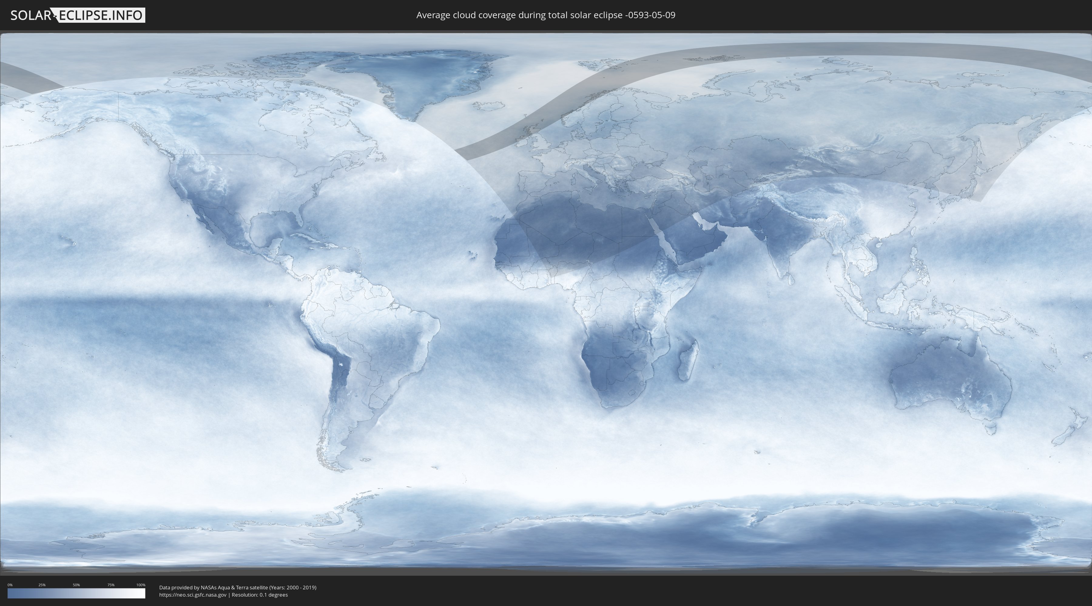
Wie wird das Wetter während der totalen Sonnenfinsternis am 09.05.-0593?
Wo ist der beste Ort, um die totale Sonnenfinsternis vom 09.05.-0593 zu beobachten?
Die folgenden Karten zeigen die durchschnittliche Bewölkung für den Tag, an dem die totale Sonnenfinsternis
stattfindet. Mit Hilfe der Karten lässt sich der Ort entlang des Finsternispfades eingrenzen,
der die besten Aussichen auf einen klaren wolkenfreien Himmel bietet.
Trotzdem muss man immer lokale Gegenenheiten beachten und sollte sich genau über das Wetter an seinem
gewählten Beobachtungsort informieren.
Die Daten stammen von den beiden NASA-Satelliten
AQUA und TERRA
und wurden über einen Zeitraum von 19 Jahren (2000 - 2019) gemittelt.

Detaillierte Länderkarten
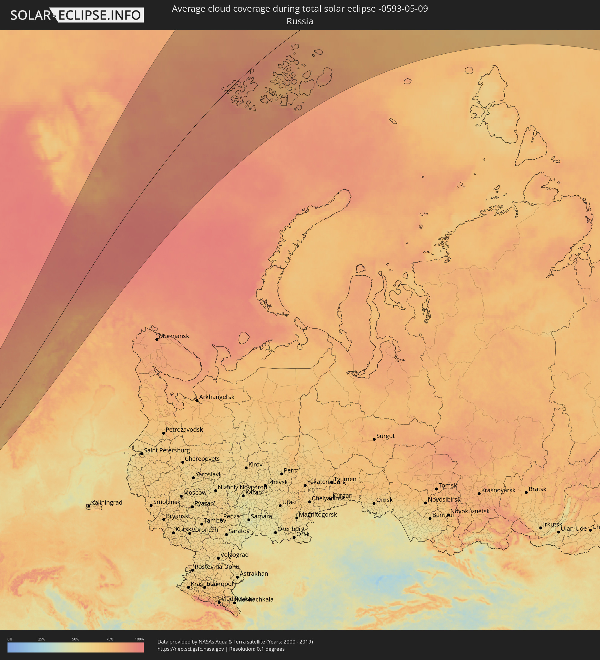 Russland
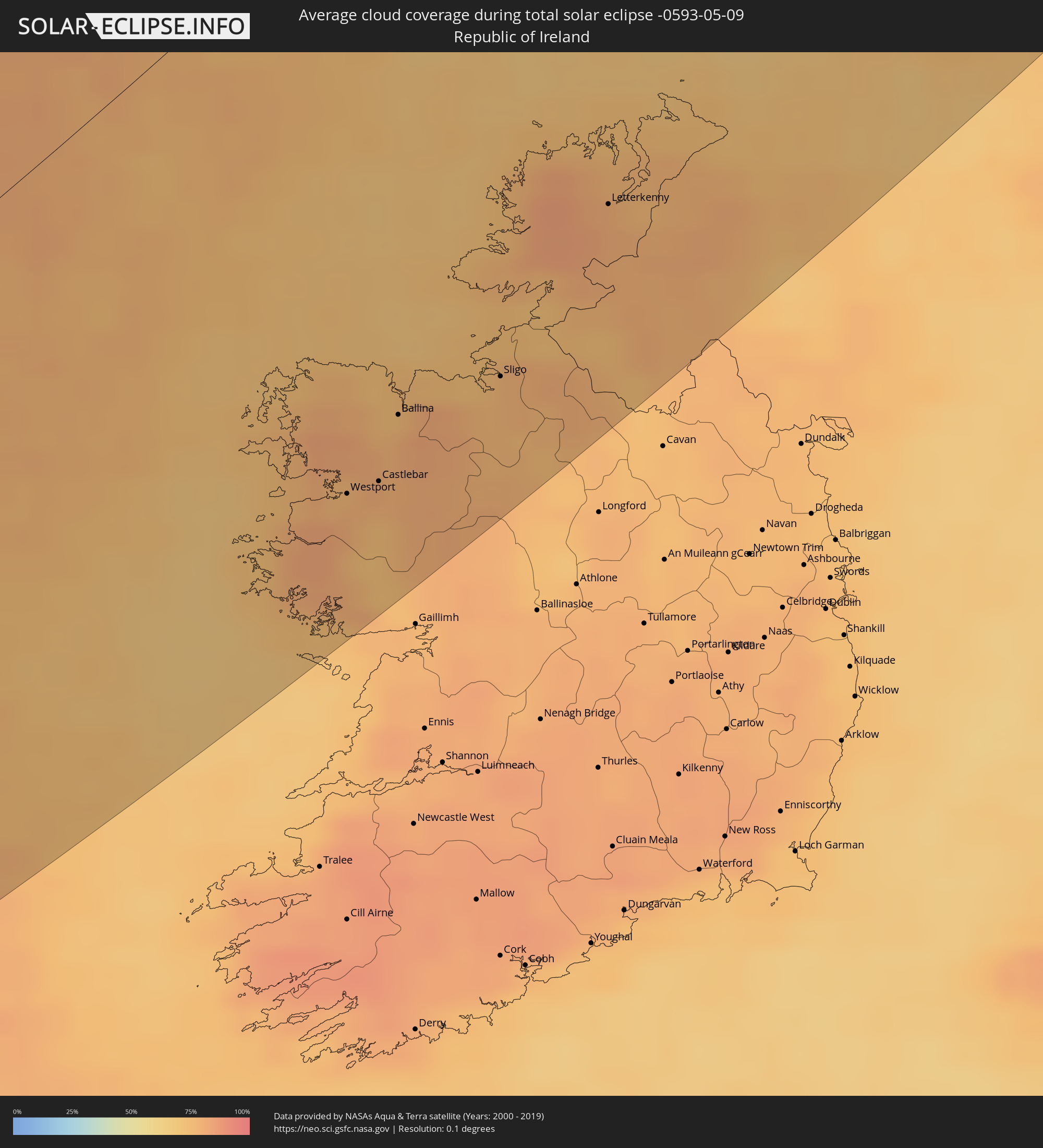 Irland
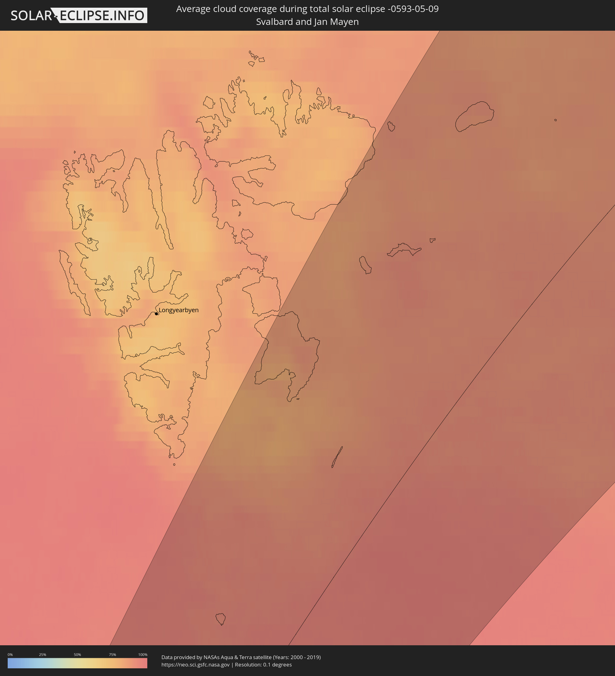 Spitzbergen
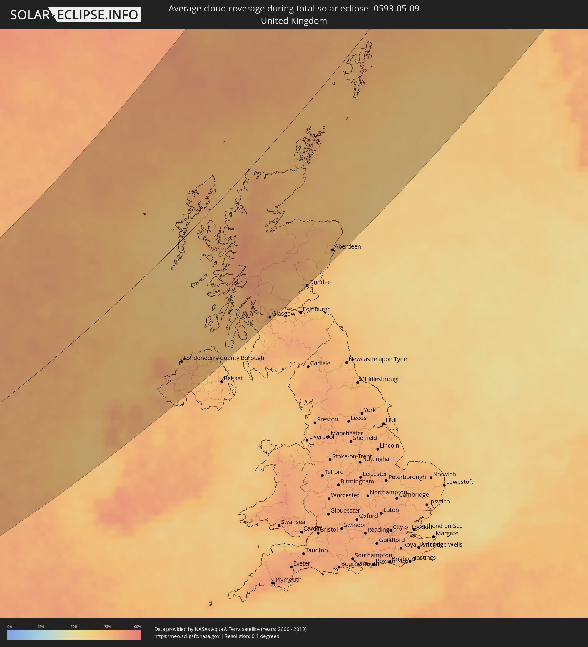 Vereinigtes Königreich
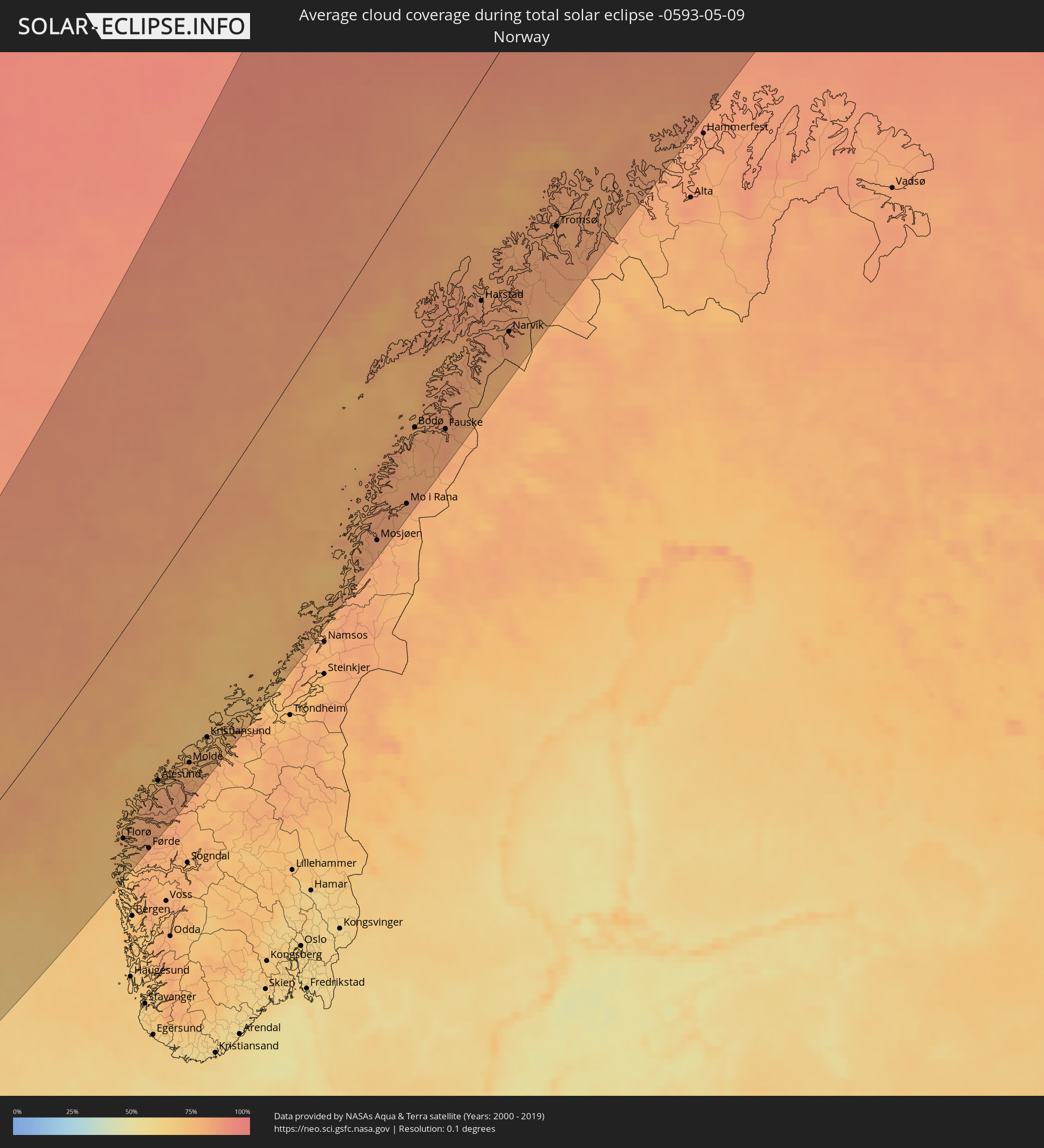 Norwegen
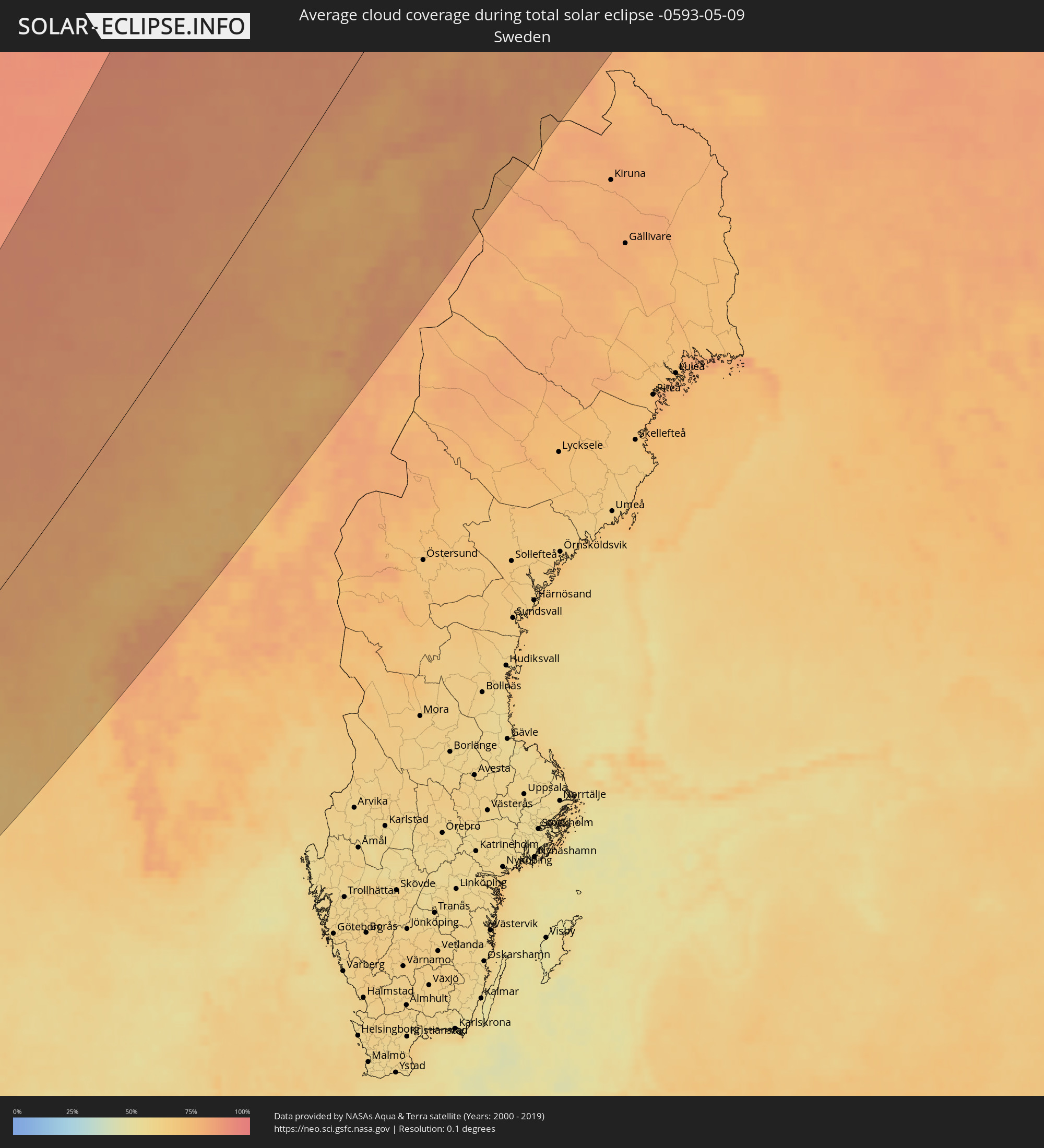 Schweden
Orte im Finsternispfad
Die nachfolgene Tabelle zeigt Städte und Orte mit mehr als 5.000 Einwohnern, die sich im Finsternispfad befinden. Städte mit mehr als 100.000 Einwohnern sind dick gekennzeichnet. Mit einem Klick auf den Ort öffnet sich eine Detailkarte die die Lage des jeweiligen Ortes zusammen mit dem Verlauf der zentralen Finsternis präsentiert.
| Ort | Typ | Dauer der Verfinsterung | Ortszeit bei maximaler Verfinsterung | Entfernung zur Zentrallinie | Ø Bewölkung |
|
Westport, Connaught
|
total | - | 06:12:23 UTC-00:25 | 199 km | 78% |
|
Castlebar, Connaught
|
total | - | 06:12:27 UTC-00:25 | 204 km | 80% |
|
Ballina, Connaught
|
total | - | 06:12:54 UTC-00:25 | 186 km | 77% |
|
Sligo, Connaught
|
total | - | 06:13:08 UTC-00:25 | 202 km | 75% |
|
Letterkenny, Ulster
|
total | - | 06:14:16 UTC-00:25 | 176 km | 79% |
|
Enniskillen, Northern Ireland
|
total | - | 06:38:35 UTC+00:00 | 230 km | 74% |
|
Strabane, Northern Ireland
|
total | - | 06:39:24 UTC+00:00 | 197 km | 79% |
|
Buncrana, Ulster
|
total | - | 06:14:35 UTC-00:25 | 172 km | 76% |
|
Londonderry County Borough, Northern Ireland
|
total | - | 06:39:42 UTC+00:00 | 190 km | 77% |
|
Omagh, Northern Ireland
|
total | - | 06:39:01 UTC+00:00 | 223 km | 77% |
|
Limavady, Northern Ireland
|
total | - | 06:39:47 UTC+00:00 | 200 km | 77% |
|
Cookstown, Northern Ireland
|
total | - | 06:39:05 UTC+00:00 | 243 km | 73% |
|
Portstewart, Northern Ireland
|
total | - | 06:40:01 UTC+00:00 | 199 km | 72% |
|
Coleraine, Northern Ireland
|
total | - | 06:39:56 UTC+00:00 | 205 km | 74% |
|
Portrush, Northern Ireland
|
total | - | 06:40:02 UTC+00:00 | 201 km | 72% |
|
Magherafelt, Northern Ireland
|
total | - | 06:39:17 UTC+00:00 | 240 km | 72% |
|
Ballymoney, Northern Ireland
|
total | - | 06:39:49 UTC+00:00 | 217 km | 75% |
|
Isle of Lewis, Scotland
|
total | - | 06:45:17 UTC+00:00 | 29 km | 77% |
|
Ballymena, Northern Ireland
|
total | - | 06:39:28 UTC+00:00 | 244 km | 74% |
|
Isle of Skye, Scotland
|
total | - | 06:43:48 UTC+00:00 | 43 km | 77% |
|
Oban, Scotland
|
total | - | 06:42:10 UTC+00:00 | 151 km | 74% |
|
Fort William, Scotland
|
total | - | 06:42:53 UTC+00:00 | 135 km | 82% |
|
Isle of Bute, Scotland
|
total | - | 06:41:11 UTC+00:00 | 216 km | 73% |
|
Dunoon, Scotland
|
total | - | 06:41:22 UTC+00:00 | 213 km | 74% |
|
Largs, Scotland
|
total | - | 06:41:07 UTC+00:00 | 227 km | 74% |
|
Gourock, Scotland
|
total | - | 06:41:24 UTC+00:00 | 216 km | 74% |
|
Ardrossan, Scotland
|
total | - | 06:40:52 UTC+00:00 | 242 km | 72% |
|
Saltcoats, Scotland
|
total | - | 06:40:50 UTC+00:00 | 244 km | 72% |
|
Greenock, Scotland
|
total | - | 06:41:23 UTC+00:00 | 219 km | 74% |
|
Stevenston, Scotland
|
total | - | 06:40:51 UTC+00:00 | 245 km | 72% |
|
Helensburgh, Scotland
|
total | - | 06:41:29 UTC+00:00 | 216 km | 73% |
|
Kilbirnie, Scotland
|
total | - | 06:41:03 UTC+00:00 | 239 km | 74% |
|
Irvine, Scotland
|
total | - | 06:40:49 UTC+00:00 | 251 km | 73% |
|
Alexandria, Scotland
|
total | - | 06:41:28 UTC+00:00 | 223 km | 74% |
|
Bonhill, Scotland
|
total | - | 06:41:27 UTC+00:00 | 225 km | 74% |
|
Houston, Scotland
|
total | - | 06:41:15 UTC+00:00 | 235 km | 75% |
|
Johnstone, Scotland
|
total | - | 06:41:11 UTC+00:00 | 239 km | 76% |
|
Stewarton, Scotland
|
total | - | 06:40:56 UTC+00:00 | 252 km | 76% |
|
Duntocher, Scotland
|
total | - | 06:41:22 UTC+00:00 | 236 km | 78% |
|
Milngavie, Scotland
|
total | - | 06:41:24 UTC+00:00 | 239 km | 78% |
|
Glasgow, Scotland
|
total | - | 06:41:16 UTC+00:00 | 248 km | 78% |
|
Inverness, Scotland
|
total | - | 06:44:06 UTC+00:00 | 121 km | 78% |
|
Kilsyth, Scotland
|
total | - | 06:41:28 UTC+00:00 | 247 km | 77% |
|
Cumbernauld, Scotland
|
total | - | 06:41:25 UTC+00:00 | 252 km | 77% |
|
Dunblane, Scotland
|
total | - | 06:41:51 UTC+00:00 | 234 km | 77% |
|
Stirling, Scotland
|
total | - | 06:41:43 UTC+00:00 | 241 km | 74% |
|
Bannockburn, Scotland
|
total | - | 06:41:41 UTC+00:00 | 244 km | 74% |
|
Denny, Scotland
|
total | - | 06:41:34 UTC+00:00 | 250 km | 74% |
|
Bonnybridge, Scotland
|
total | - | 06:41:31 UTC+00:00 | 252 km | 74% |
|
Nairn, Scotland
|
total | - | 06:44:18 UTC+00:00 | 127 km | 76% |
|
Crieff, Scotland
|
total | - | 06:42:11 UTC+00:00 | 224 km | 77% |
|
Forres, Scotland
|
total | - | 06:44:22 UTC+00:00 | 137 km | 77% |
|
Thurso, Scotland
|
total | - | 06:46:07 UTC+00:00 | 65 km | 73% |
|
Perth, Scotland
|
total | - | 06:42:14 UTC+00:00 | 240 km | 73% |
|
Blairgowrie, Scotland
|
total | - | 06:42:36 UTC+00:00 | 228 km | 76% |
|
Elgin, Scotland
|
total | - | 06:44:28 UTC+00:00 | 146 km | 77% |
|
Lossiemouth, Scotland
|
total | - | 06:44:35 UTC+00:00 | 142 km | 75% |
|
Wick, Scotland
|
total | - | 06:45:53 UTC+00:00 | 95 km | 75% |
|
Buckie, Scotland
|
total | - | 06:44:32 UTC+00:00 | 159 km | 74% |
|
Orkney, Scotland
|
total | - | 06:46:52 UTC+00:00 | 63 km | 77% |
|
Kirkwall, Scotland
|
total | - | 06:46:52 UTC+00:00 | 63 km | 77% |
|
Forfar, Scotland
|
total | - | 06:42:43 UTC+00:00 | 243 km | 74% |
|
Brechin, Scotland
|
total | - | 06:42:53 UTC+00:00 | 246 km | 73% |
|
Inverurie, Scotland
|
total | - | 06:43:54 UTC+00:00 | 214 km | 75% |
|
Westhill, Scotland
|
total | - | 06:43:40 UTC+00:00 | 229 km | 74% |
|
Stonehaven, Scotland
|
total | - | 06:43:21 UTC+00:00 | 247 km | 72% |
|
Portlethen, Scotland
|
total | - | 06:43:31 UTC+00:00 | 243 km | 71% |
|
Aberdeen, Scotland
|
total | - | 06:43:40 UTC+00:00 | 237 km | 71% |
|
Ellon, Scotland
|
total | - | 06:44:04 UTC+00:00 | 221 km | 74% |
|
Fraserburgh, Scotland
|
total | - | 06:44:39 UTC+00:00 | 198 km | 69% |
|
Peterhead, Scotland
|
total | - | 06:44:21 UTC+00:00 | 222 km | 72% |
|
Lerwick, Scotland
|
total | - | 06:49:09 UTC+00:00 | 52 km | 78% |
|
Shetland, Scotland
|
total | - | 06:49:09 UTC+00:00 | 52 km | 78% |
|
Florø, Sogn og Fjordane
|
total | - | 07:52:53 UTC+01:00 | 204 km | 76% |
|
Ulsteinvik, Møre og Romsdal
|
total | - | 07:54:25 UTC+01:00 | 185 km | 78% |
|
Førde, Sogn og Fjordane
|
total | - | 07:52:48 UTC+01:00 | 248 km | 82% |
|
Volda, Møre og Romsdal
|
total | - | 07:54:07 UTC+01:00 | 208 km | 81% |
|
Ørsta, Møre og Romsdal
|
total | - | 07:54:14 UTC+01:00 | 206 km | 79% |
|
Ålesund, Møre og Romsdal
|
total | - | 07:54:44 UTC+01:00 | 189 km | 77% |
|
Molde, Møre og Romsdal
|
total | - | 07:55:28 UTC+01:00 | 211 km | 76% |
|
Kristiansund, Møre og Romsdal
|
total | - | 07:56:18 UTC+01:00 | 207 km | 72% |
|
Sandnessjøen, Nordland
|
total | - | 08:03:01 UTC+01:00 | 196 km | 80% |
|
Mosjøen, Nordland
|
total | - | 08:02:52 UTC+01:00 | 229 km | 82% |
|
Mo i Rana, Nordland
|
total | - | 08:04:02 UTC+01:00 | 232 km | 82% |
|
Bodø, Nordland
|
total | - | 08:05:50 UTC+01:00 | 176 km | 78% |
|
Fauske, Nordland
|
total | - | 08:06:08 UTC+01:00 | 212 km | 83% |
|
Harstad, Troms
|
total | - | 08:09:12 UTC+01:00 | 150 km | 84% |
|
Narvik, Nordland
|
total | - | 08:08:54 UTC+01:00 | 204 km | 84% |
|
Tromsø, Troms
|
total | - | 08:11:31 UTC+01:00 | 173 km | 83% |