Ringförmige Sonnenfinsternis vom 25.11.-0975
| Wochentag: | Mittwoch |
| Maximale Dauer der Verfinsterung: | 07m19s |
| Maximale Breite des Finsternispfades: | 326 km |
| Saroszyklus: | 46 |
| Bedeckungsgrad: | 92.5% |
| Magnitude: | 0.9252 |
| Gamma: | -0.5096 |
Wo kann man die Sonnenfinsternis vom 25.11.-0975 sehen?

Die Sonnenfinsternis am 25.11.-0975 kann man in 22 Ländern als partielle Sonnenfinsternis beobachten.
Der Finsternispfad verläuft durch 3 Länder. Nur in diesen Ländern ist sie als ringförmige Sonnenfinsternis zu sehen.
In den folgenden Ländern ist die Sonnenfinsternis ringförmig zu sehen
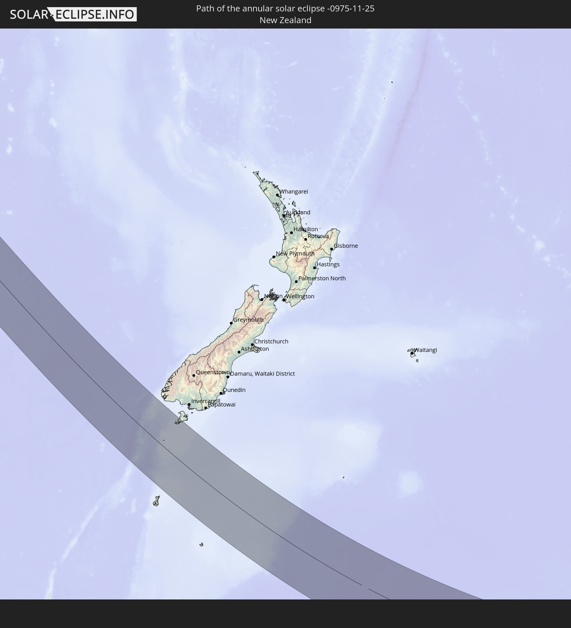 Neuseeland
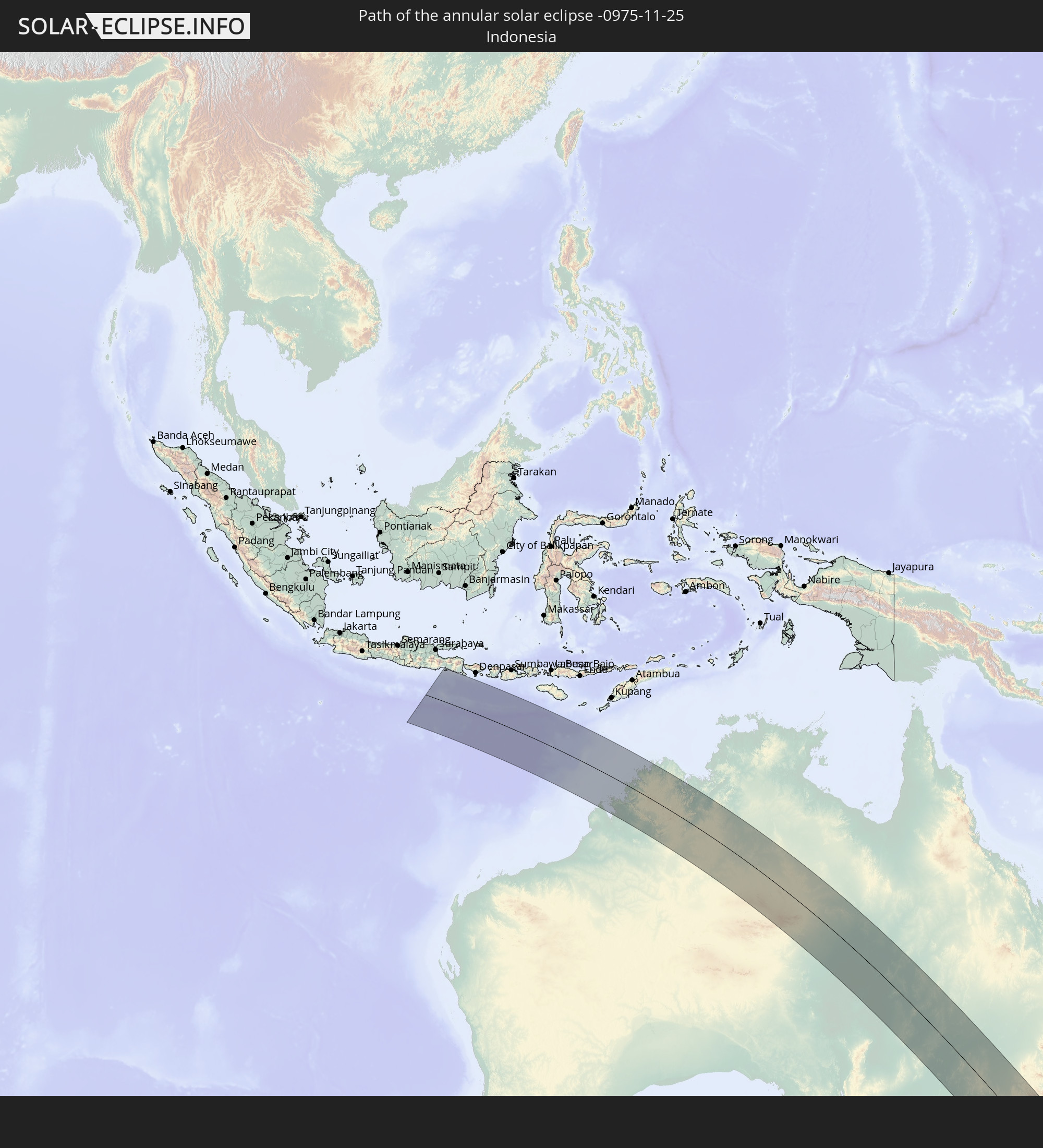 Indonesien
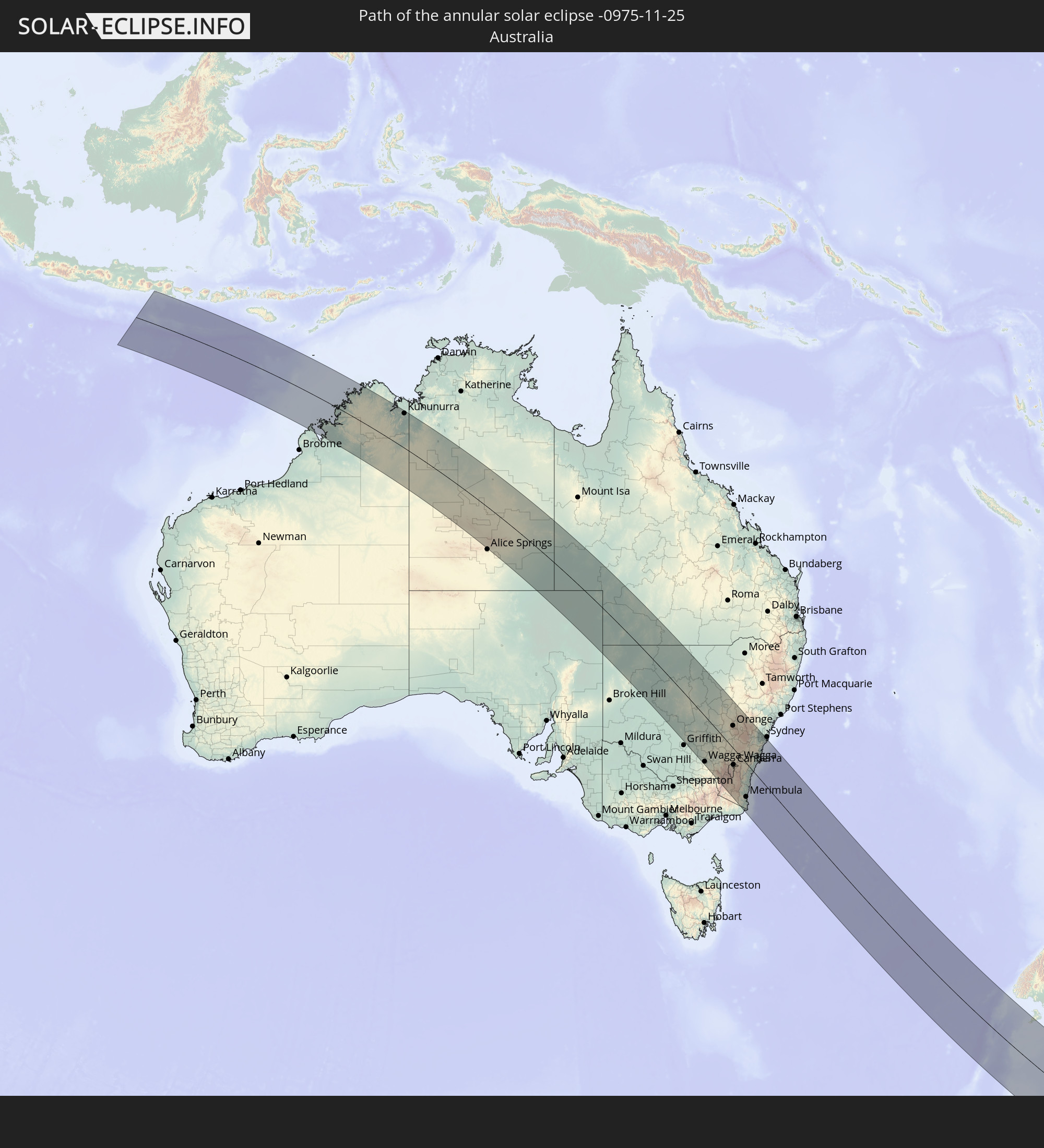 Australien
In den folgenden Ländern ist die Sonnenfinsternis partiell zu sehen
 Antarktika
 Fidschi
 Neuseeland
 Wallis und Futuna
 Tonga
Tonga
 Französisch-Polynesien
 Pitcairninseln
 Heard und McDonaldinseln
 Indonesien
 Australien
 Philippinen
 Osttimor
 Palau
Palau
 Föderierte Staaten von Mikronesien
 Papua-Neuguinea
 Guam
Guam
 Nördliche Marianen
 Salomonen
 Neukaledonien
 Vanuatu
 Nauru
Nauru
 Norfolkinsel
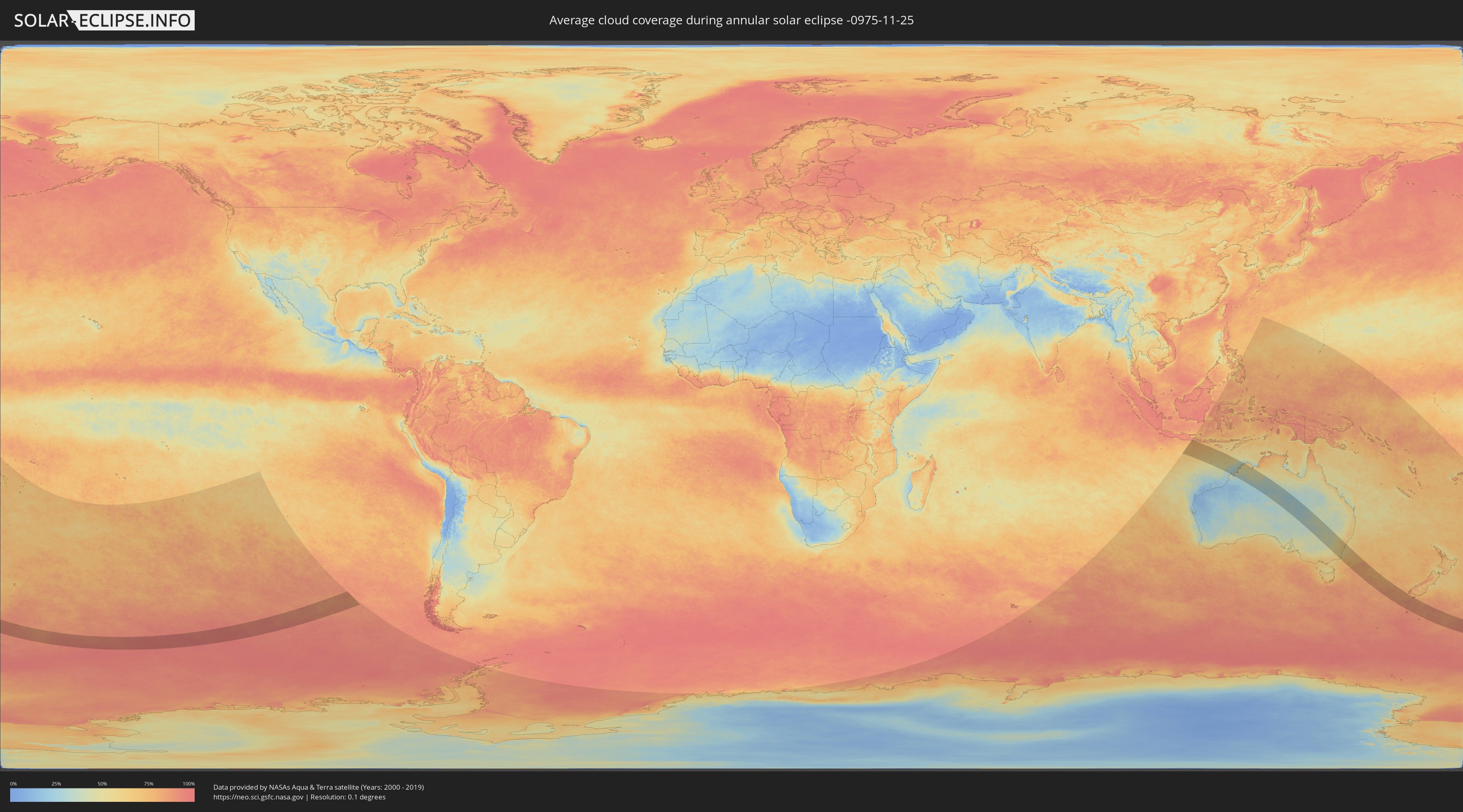
Wie wird das Wetter während der ringförmigen Sonnenfinsternis am 25.11.-0975?
Wo ist der beste Ort, um die ringförmige Sonnenfinsternis vom 25.11.-0975 zu beobachten?
Die folgenden Karten zeigen die durchschnittliche Bewölkung für den Tag, an dem die ringförmige Sonnenfinsternis
stattfindet. Mit Hilfe der Karten lässt sich der Ort entlang des Finsternispfades eingrenzen,
der die besten Aussichen auf einen klaren wolkenfreien Himmel bietet.
Trotzdem muss man immer lokale Gegenenheiten beachten und sollte sich genau über das Wetter an seinem
gewählten Beobachtungsort informieren.
Die Daten stammen von den beiden NASA-Satelliten
AQUA und TERRA
und wurden über einen Zeitraum von 19 Jahren (2000 - 2019) gemittelt.

Detaillierte Länderkarten
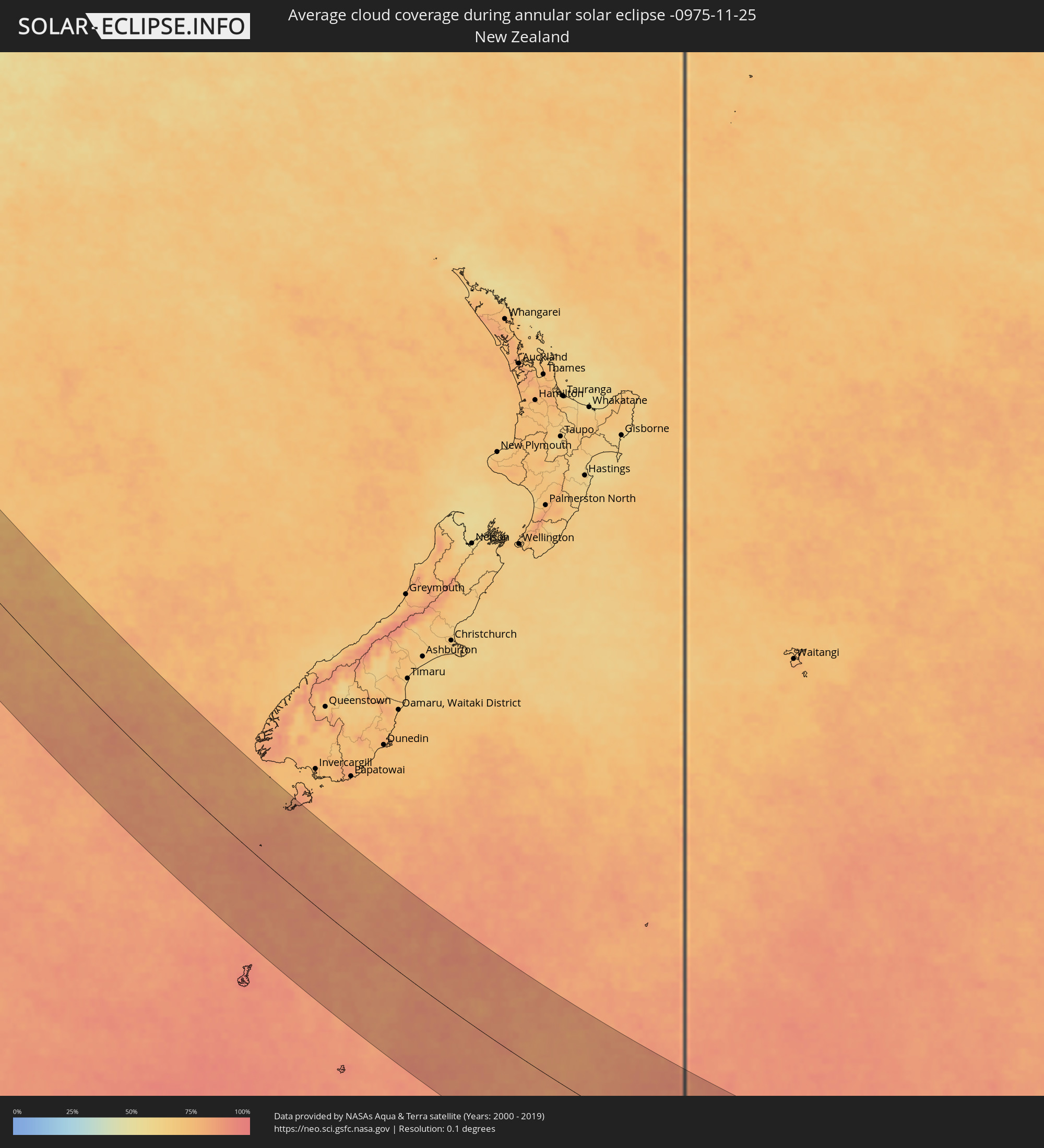 Neuseeland
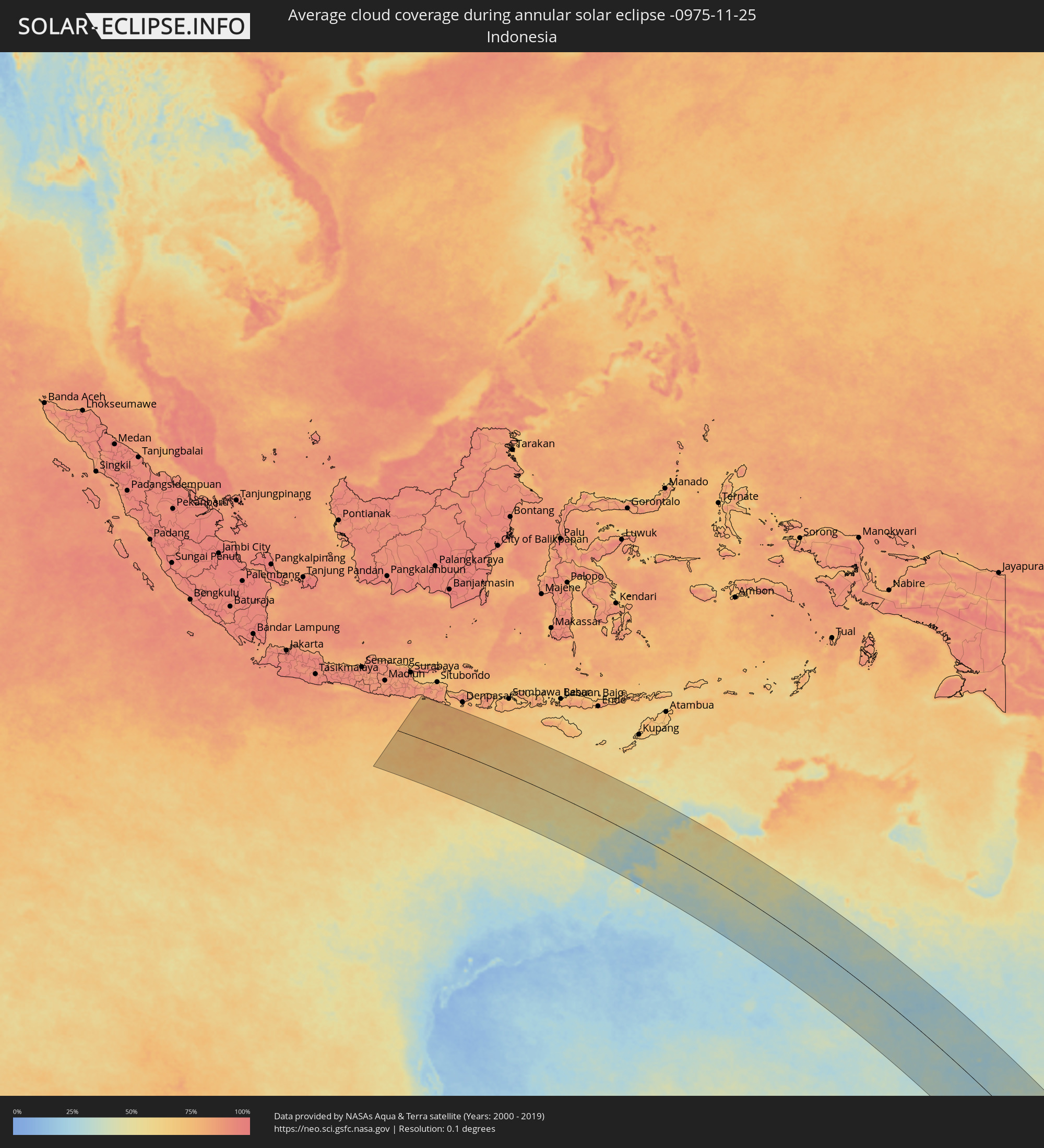 Indonesien
 Australien
Orte im Finsternispfad
Die nachfolgene Tabelle zeigt Städte und Orte mit mehr als 5.000 Einwohnern, die sich im Finsternispfad befinden. Städte mit mehr als 100.000 Einwohnern sind dick gekennzeichnet. Mit einem Klick auf den Ort öffnet sich eine Detailkarte die die Lage des jeweiligen Ortes zusammen mit dem Verlauf der zentralen Finsternis präsentiert.
| Ort | Typ | Dauer der Verfinsterung | Ortszeit bei maximaler Verfinsterung | Entfernung zur Zentrallinie | Ø Bewölkung |
|
Kununurra, Western Australia
|
ringförmig | - | 06:13:45 UTC+08:00 | 193 km | 51% |
|
Wagga Wagga, New South Wales
|
ringförmig | - | 09:00:40 UTC+10:00 | 171 km | 50% |
|
Lake Albert, New South Wales
|
ringförmig | - | 09:00:47 UTC+10:00 | 172 km | 50% |
|
Parkes, New South Wales
|
ringförmig | - | 08:57:03 UTC+10:00 | 32 km | 48% |
|
Tumut, New South Wales
|
ringförmig | - | 09:01:55 UTC+10:00 | 123 km | 50% |
|
Young, New South Wales
|
ringförmig | - | 08:59:47 UTC+10:00 | 46 km | 52% |
|
Dubbo, New South Wales
|
ringförmig | - | 08:55:28 UTC+10:00 | 128 km | 47% |
|
Cowra, New South Wales
|
ringförmig | - | 08:59:07 UTC+10:00 | 16 km | 52% |
|
Yass, New South Wales
|
ringförmig | - | 09:01:35 UTC+10:00 | 42 km | 54% |
|
Wellington, New South Wales
|
ringförmig | - | 08:56:30 UTC+10:00 | 128 km | 48% |
|
Orange, New South Wales
|
ringförmig | - | 08:58:17 UTC+10:00 | 85 km | 55% |
|
Kaleen, Australian Capital Territory
|
ringförmig | - | 09:02:37 UTC+10:00 | 56 km | 56% |
|
Cooma, New South Wales
|
ringförmig | - | 09:04:55 UTC+10:00 | 129 km | 56% |
|
Canberra, Australian Capital Territory
|
ringförmig | - | 09:02:47 UTC+10:00 | 60 km | 55% |
|
Queanbeyan, New South Wales
|
ringförmig | - | 09:03:04 UTC+10:00 | 58 km | 58% |
|
Bathurst, New South Wales
|
ringförmig | - | 08:59:05 UTC+10:00 | 109 km | 57% |
|
Mudgee, New South Wales
|
ringförmig | - | 08:57:14 UTC+10:00 | 170 km | 50% |
|
Kelso, New South Wales
|
ringförmig | - | 08:59:06 UTC+10:00 | 110 km | 57% |
|
Goulburn, New South Wales
|
ringförmig | - | 09:02:13 UTC+10:00 | 20 km | 60% |
|
Merimbula, New South Wales
|
ringförmig | - | 09:07:13 UTC+10:00 | 122 km | 59% |
|
Lithgow, New South Wales
|
ringförmig | - | 08:59:48 UTC+10:00 | 142 km | 59% |
|
Batemans Bay, New South Wales
|
ringförmig | - | 09:04:51 UTC+10:00 | 18 km | 60% |
|
Katoomba, New South Wales
|
ringförmig | - | 09:00:31 UTC+10:00 | 137 km | 65% |
|
Moss Vale, New South Wales
|
ringförmig | - | 09:02:28 UTC+10:00 | 79 km | 67% |
|
Bowral, New South Wales
|
ringförmig | - | 09:02:21 UTC+10:00 | 88 km | 67% |
|
Mittagong, New South Wales
|
ringförmig | - | 09:02:19 UTC+10:00 | 92 km | 67% |
|
Ulladulla, New South Wales
|
ringförmig | - | 09:04:23 UTC+10:00 | 27 km | 61% |
|
Blaxland, New South Wales
|
ringförmig | - | 09:00:54 UTC+10:00 | 154 km | 66% |
|
Nowra, New South Wales
|
ringförmig | - | 09:03:27 UTC+10:00 | 71 km | 63% |
|
Bomaderry, New South Wales
|
ringförmig | - | 09:03:23 UTC+10:00 | 74 km | 64% |
|
Glenbrook, New South Wales
|
ringförmig | - | 09:00:57 UTC+10:00 | 154 km | 66% |
|
Glenmore Park, New South Wales
|
ringförmig | - | 09:01:04 UTC+10:00 | 156 km | 66% |
|
Penrith, New South Wales
|
ringförmig | - | 09:01:00 UTC+10:00 | 161 km | 66% |
|
Kingswood Park, New South Wales
|
ringförmig | - | 09:01:03 UTC+10:00 | 161 km | 66% |
|
Cambridge Park, New South Wales
|
ringförmig | - | 09:01:01 UTC+10:00 | 163 km | 66% |
|
Narellan, New South Wales
|
ringförmig | - | 09:01:41 UTC+10:00 | 143 km | 65% |
|
Narellan Vale, New South Wales
|
ringförmig | - | 09:01:44 UTC+10:00 | 142 km | 65% |
|
Richmond, New South Wales
|
ringförmig | - | 09:00:43 UTC+10:00 | 176 km | 66% |
|
Dapto, New South Wales
|
ringförmig | - | 09:02:47 UTC+10:00 | 112 km | 69% |
|
Albion Park Rail, New South Wales
|
ringförmig | - | 09:02:56 UTC+10:00 | 108 km | 67% |
|
South Windsor, New South Wales
|
ringförmig | - | 09:00:49 UTC+10:00 | 178 km | 66% |
|
Mount Druitt, New South Wales
|
ringförmig | - | 09:01:10 UTC+10:00 | 168 km | 66% |
|
Campbelltown, New South Wales
|
ringförmig | - | 09:01:51 UTC+10:00 | 146 km | 64% |
|
Leumeah, New South Wales
|
ringförmig | - | 09:01:50 UTC+10:00 | 148 km | 64% |
|
Cordeaux Heights, New South Wales
|
ringförmig | - | 09:02:43 UTC+10:00 | 120 km | 69% |
|
Berkeley, New South Wales
|
ringförmig | - | 09:02:49 UTC+10:00 | 117 km | 68% |
|
Kiama, New South Wales
|
ringförmig | - | 09:03:14 UTC+10:00 | 104 km | 62% |
|
Glendenning, New South Wales
|
ringförmig | - | 09:01:10 UTC+10:00 | 172 km | 65% |
|
Barrack Heights, New South Wales
|
ringförmig | - | 09:03:01 UTC+10:00 | 112 km | 66% |
|
Doonside, New South Wales
|
ringförmig | - | 09:01:13 UTC+10:00 | 172 km | 64% |
|
Riverstone, New South Wales
|
ringförmig | - | 09:01:02 UTC+10:00 | 178 km | 65% |
|
Ingleburn, New South Wales
|
ringförmig | - | 09:01:45 UTC+10:00 | 154 km | 62% |
|
Quakers Hill, New South Wales
|
ringförmig | - | 09:01:10 UTC+10:00 | 175 km | 65% |
|
Fairy Meadow, New South Wales
|
ringförmig | - | 09:02:40 UTC+10:00 | 127 km | 70% |
|
Wollongong, New South Wales
|
ringförmig | - | 09:02:44 UTC+10:00 | 125 km | 70% |
|
Glenfield, New South Wales
|
ringförmig | - | 09:01:43 UTC+10:00 | 159 km | 62% |
|
Corrimal, New South Wales
|
ringförmig | - | 09:02:39 UTC+10:00 | 129 km | 70% |
|
Cabramatta West, New South Wales
|
ringförmig | - | 09:01:34 UTC+10:00 | 165 km | 64% |
|
Bulli, New South Wales
|
ringförmig | - | 09:02:34 UTC+10:00 | 133 km | 69% |
|
Blacktown, New South Wales
|
ringförmig | - | 09:01:17 UTC+10:00 | 175 km | 64% |
|
Liverpool, New South Wales
|
ringförmig | - | 09:01:36 UTC+10:00 | 166 km | 64% |
|
Fairfield Heights, New South Wales
|
ringförmig | - | 09:01:31 UTC+10:00 | 169 km | 64% |
|
Chipping Norton, New South Wales
|
ringförmig | - | 09:01:37 UTC+10:00 | 168 km | 63% |
|
Fairfield East, New South Wales
|
ringförmig | - | 09:01:34 UTC+10:00 | 171 km | 63% |
|
Merrylands, New South Wales
|
ringförmig | - | 09:01:30 UTC+10:00 | 175 km | 63% |
|
Helensburgh, New South Wales
|
ringförmig | - | 09:02:17 UTC+10:00 | 150 km | 67% |
|
City of Parramatta, New South Wales
|
ringförmig | - | 09:01:29 UTC+10:00 | 177 km | 63% |
|
Paramatta, New South Wales
|
ringförmig | - | 09:01:29 UTC+10:00 | 177 km | 63% |
|
Harris Park, New South Wales
|
ringförmig | - | 09:01:30 UTC+10:00 | 177 km | 63% |
|
Engadine, New South Wales
|
ringförmig | - | 09:02:03 UTC+10:00 | 160 km | 64% |
|
Heathcote, New South Wales
|
ringförmig | - | 09:02:06 UTC+10:00 | 158 km | 64% |
|
Menai, New South Wales
|
ringförmig | - | 09:01:57 UTC+10:00 | 163 km | 61% |
|
Granville, New South Wales
|
ringförmig | - | 09:01:32 UTC+10:00 | 177 km | 63% |
|
Auburn, New South Wales
|
ringförmig | - | 09:01:35 UTC+10:00 | 177 km | 63% |
|
Bankstown, New South Wales
|
ringförmig | - | 09:01:45 UTC+10:00 | 172 km | 63% |
|
Berala, New South Wales
|
ringförmig | - | 09:01:38 UTC+10:00 | 175 km | 63% |
|
Lidcombe, New South Wales
|
ringförmig | - | 09:01:38 UTC+10:00 | 176 km | 63% |
|
Lugarno, New South Wales
|
ringförmig | - | 09:01:54 UTC+10:00 | 168 km | 61% |
|
Jannali, New South Wales
|
ringförmig | - | 09:02:00 UTC+10:00 | 166 km | 60% |
|
Kirrawee, New South Wales
|
ringförmig | - | 09:02:03 UTC+10:00 | 165 km | 60% |
|
Oatley, New South Wales
|
ringförmig | - | 09:01:56 UTC+10:00 | 170 km | 60% |
|
Lakemba, New South Wales
|
ringförmig | - | 09:01:48 UTC+10:00 | 175 km | 63% |
|
Mortdale, New South Wales
|
ringförmig | - | 09:01:55 UTC+10:00 | 172 km | 60% |
|
Penshurst, New South Wales
|
ringförmig | - | 09:01:55 UTC+10:00 | 172 km | 60% |
|
Belfield, New South Wales
|
ringförmig | - | 09:01:46 UTC+10:00 | 177 km | 63% |
|
Gymea, New South Wales
|
ringförmig | - | 09:02:04 UTC+10:00 | 167 km | 60% |
|
Gymea Bay, New South Wales
|
ringförmig | - | 09:02:06 UTC+10:00 | 166 km | 64% |
|
Earlwood, New South Wales
|
ringförmig | - | 09:01:53 UTC+10:00 | 174 km | 60% |
|
Miranda, New South Wales
|
ringförmig | - | 09:02:05 UTC+10:00 | 168 km | 60% |
|
Blakehurst, New South Wales
|
ringförmig | - | 09:02:00 UTC+10:00 | 172 km | 60% |
|
Caringbah, New South Wales
|
ringförmig | - | 09:02:08 UTC+10:00 | 168 km | 60% |
|
Caringbah South, New South Wales
|
ringförmig | - | 09:02:09 UTC+10:00 | 168 km | 64% |
|
Cronulla, New South Wales
|
ringförmig | - | 09:02:12 UTC+10:00 | 169 km | 64% |
|
Brighton-Le-Sands, New South Wales
|
ringförmig | - | 09:01:58 UTC+10:00 | 177 km | 61% |