Totale Sonnenfinsternis vom 21.02.-1267
| Wochentag: | Montag |
| Maximale Dauer der Verfinsterung: | 04m05s |
| Maximale Breite des Finsternispfades: | 275 km |
| Saroszyklus: | 39 |
| Bedeckungsgrad: | 100% |
| Magnitude: | 1.0515 |
| Gamma: | 0.7933 |
Wo kann man die Sonnenfinsternis vom 21.02.-1267 sehen?

Die Sonnenfinsternis am 21.02.-1267 kann man in 17 Ländern als partielle Sonnenfinsternis beobachten.
Der Finsternispfad verläuft durch 2 Länder. Nur in diesen Ländern ist sie als totale Sonnenfinsternis zu sehen.
In den folgenden Ländern ist die Sonnenfinsternis total zu sehen
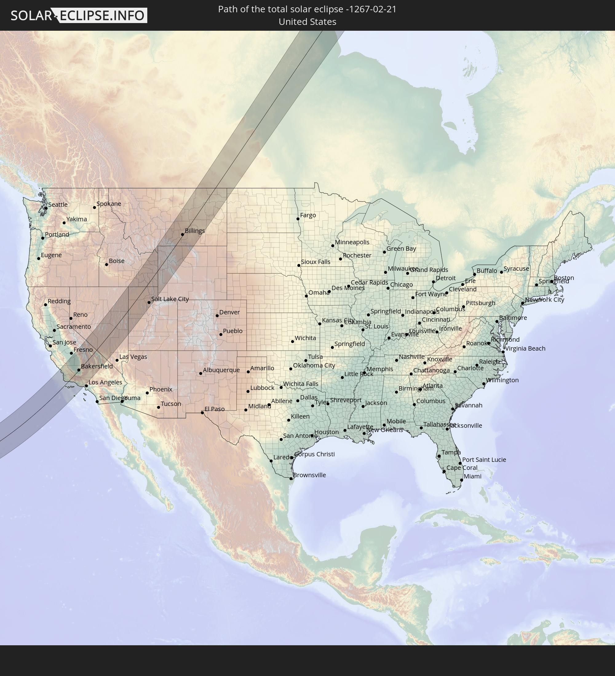 Vereinigte Staaten
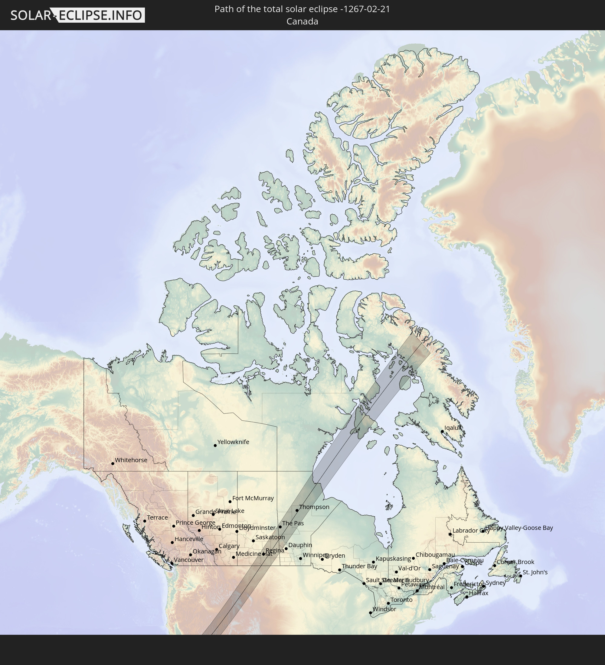 Kanada
In den folgenden Ländern ist die Sonnenfinsternis partiell zu sehen


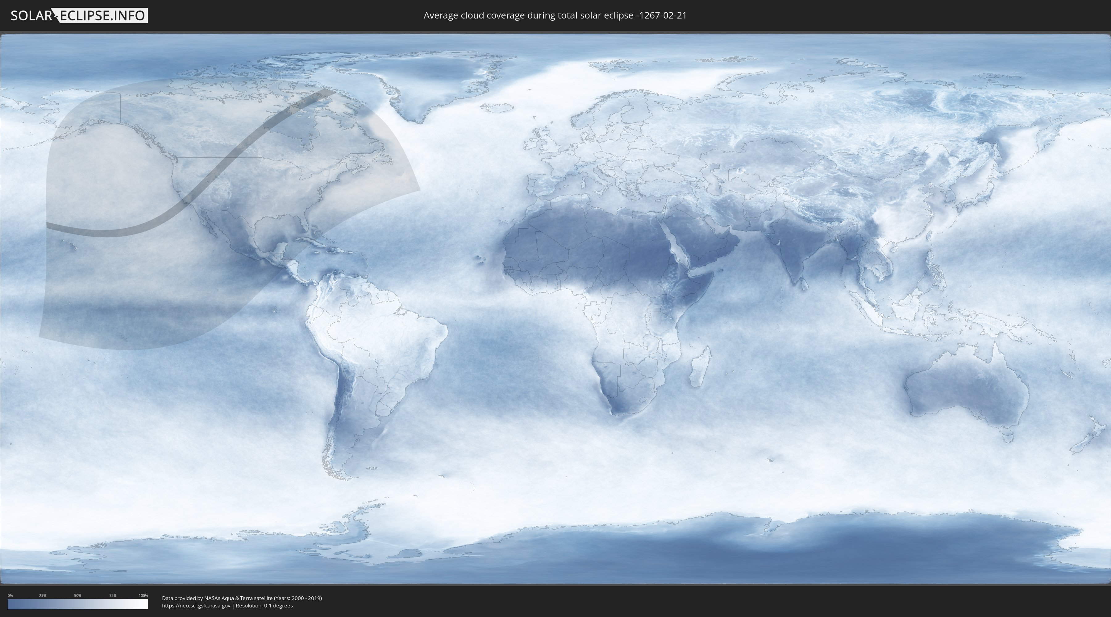
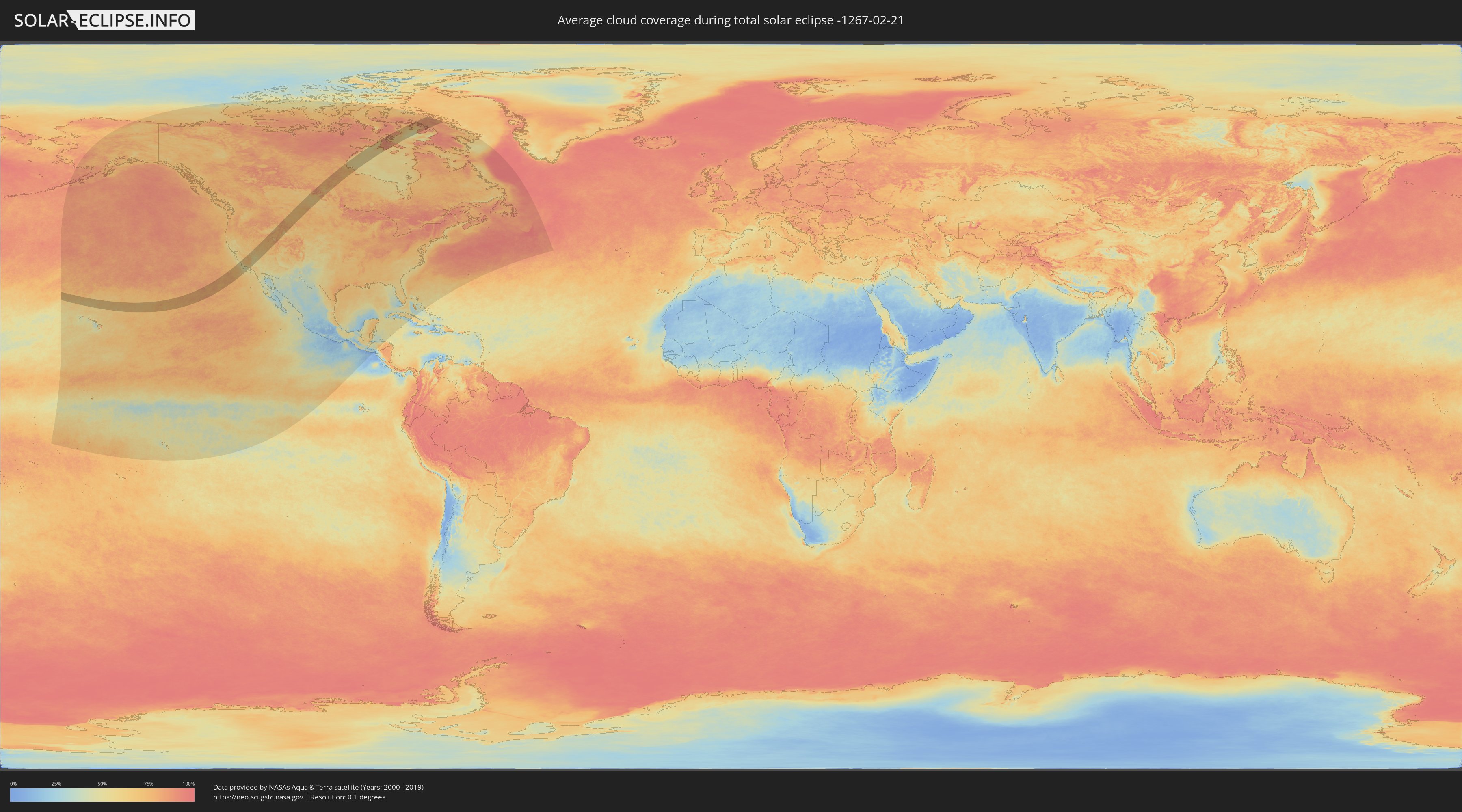
Wie wird das Wetter während der totalen Sonnenfinsternis am 21.02.-1267?
Wo ist der beste Ort, um die totale Sonnenfinsternis vom 21.02.-1267 zu beobachten?
Die folgenden Karten zeigen die durchschnittliche Bewölkung für den Tag, an dem die totale Sonnenfinsternis
stattfindet. Mit Hilfe der Karten lässt sich der Ort entlang des Finsternispfades eingrenzen,
der die besten Aussichen auf einen klaren wolkenfreien Himmel bietet.
Trotzdem muss man immer lokale Gegenenheiten beachten und sollte sich genau über das Wetter an seinem
gewählten Beobachtungsort informieren.
Die Daten stammen von den beiden NASA-Satelliten
AQUA und TERRA
und wurden über einen Zeitraum von 19 Jahren (2000 - 2019) gemittelt.
Detaillierte Länderkarten
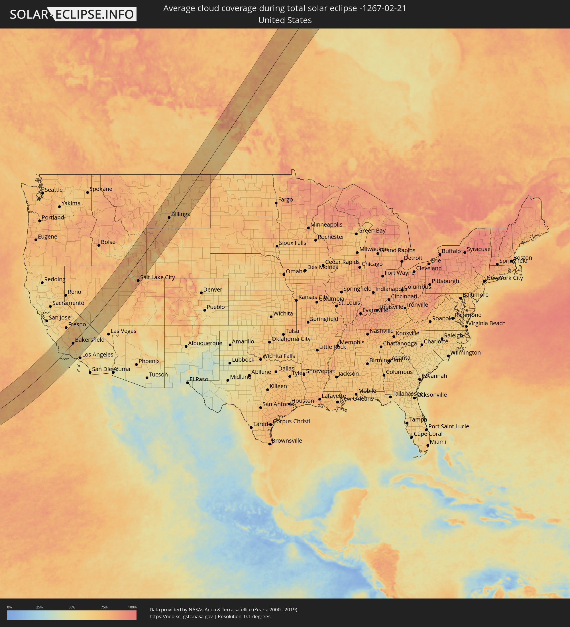 Vereinigte Staaten
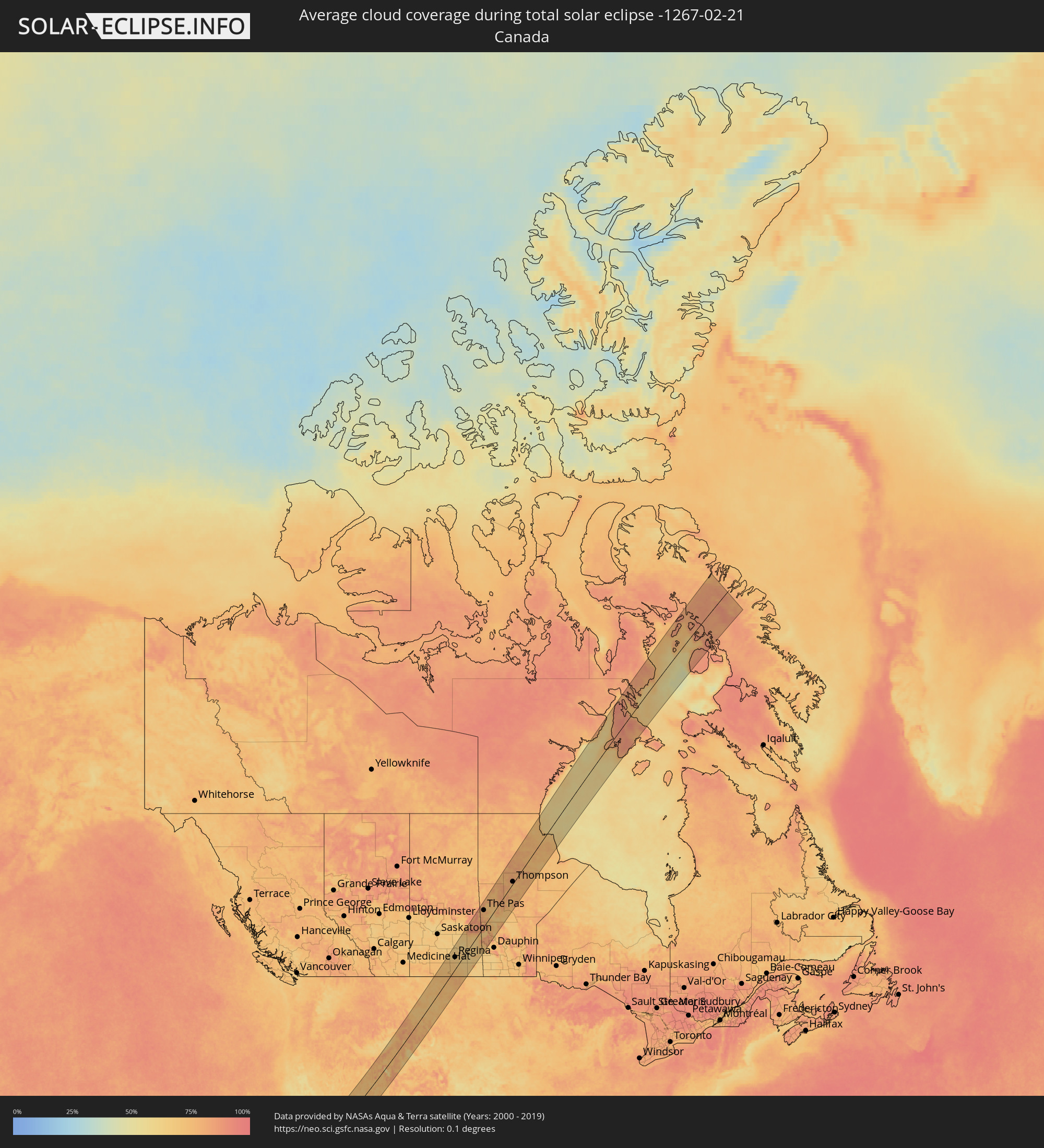 Kanada
Orte im Finsternispfad
Die nachfolgene Tabelle zeigt Städte und Orte mit mehr als 5.000 Einwohnern, die sich im Finsternispfad befinden. Städte mit mehr als 100.000 Einwohnern sind dick gekennzeichnet. Mit einem Klick auf den Ort öffnet sich eine Detailkarte die die Lage des jeweiligen Ortes zusammen mit dem Verlauf der zentralen Finsternis präsentiert.
| Ort | Typ | Dauer der Verfinsterung | Ortszeit bei maximaler Verfinsterung | Entfernung zur Zentrallinie | Ø Bewölkung |
 Morro Bay, California
|
total | - | 10:57:30 UTC-08:00 | 120 km | 53% |
|
Los Osos, California
|
total | - | 10:57:28 UTC-08:00 | 115 km | 52% |
|
Templeton, California
|
total | - | 10:58:01 UTC-08:00 | 124 km | 60% |
|
Paso Robles, California
|
total | - | 10:58:10 UTC-08:00 | 129 km | 62% |
|
Atascadero, California
|
total | - | 10:58:00 UTC-08:00 | 117 km | 60% |
|
San Luis Obispo, California
|
total | - | 10:57:44 UTC-08:00 | 101 km | 56% |
|
Pismo Beach, California
|
total | - | 10:57:34 UTC-08:00 | 89 km | 53% |
|
Grover Beach, California
|
total | - | 10:57:34 UTC-08:00 | 86 km | 53% |
|
Arroyo Grande, California
|
total | - | 10:57:37 UTC-08:00 | 84 km | 53% |
|
Nipomo, California
|
total | - | 10:57:43 UTC-08:00 | 71 km | 58% |
|
Lompoc, California
|
total | - | 10:57:11 UTC-08:00 | 39 km | 54% |
|
Santa Maria, California
|
total | - | 10:57:40 UTC-08:00 | 61 km | 58% |
|
Avenal, California
|
total | - | 10:59:41 UTC-08:00 | 120 km | 68% |
|
Santa Barbara, California
|
total | - | 10:58:14 UTC-08:00 | 29 km | 48% |
|
Hanford, California
|
total | - | 11:00:59 UTC-08:00 | 111 km | 69% |
|
Montecito, California
|
total | - | 10:58:23 UTC-08:00 | 32 km | 47% |
|
Corcoran, California
|
total | - | 11:00:49 UTC-08:00 | 88 km | 67% |
|
Sanger, California
|
total | - | 11:01:40 UTC-08:00 | 133 km | 70% |
|
Kingsburg, California
|
total | - | 11:01:24 UTC-08:00 | 119 km | 69% |
|
Parlier, California
|
total | - | 11:01:35 UTC-08:00 | 124 km | 69% |
|
Carpinteria, California
|
total | - | 10:58:32 UTC-08:00 | 42 km | 49% |
|
Taft, California
|
total | - | 10:59:41 UTC-08:00 | 10 km | 67% |
|
Reedley, California
|
total | - | 11:01:42 UTC-08:00 | 118 km | 69% |
|
Wasco, California
|
total | - | 11:00:31 UTC-08:00 | 36 km | 70% |
|
Orange Cove, California
|
total | - | 11:01:59 UTC-08:00 | 110 km | 70% |
|
Visalia, California
|
total | - | 11:01:37 UTC-08:00 | 87 km | 68% |
|
Orosi, California
|
total | - | 11:01:55 UTC-08:00 | 103 km | 70% |
|
Earlimart, California
|
total | - | 11:01:03 UTC-08:00 | 53 km | 74% |
|
Shafter, California
|
total | - | 11:00:31 UTC-08:00 | 25 km | 73% |
|
Delano, California
|
total | - | 11:00:56 UTC-08:00 | 43 km | 72% |
|
McFarland, California
|
total | - | 11:00:50 UTC-08:00 | 35 km | 71% |
|
Farmersville, California
|
total | - | 11:01:43 UTC-08:00 | 79 km | 69% |
|
Oxnard, California
|
total | - | 10:58:52 UTC-08:00 | 80 km | 51% |
|
Rosedale, California
|
total | - | 11:00:35 UTC-08:00 | 7 km | 73% |
|
Exeter, California
|
total | - | 11:01:50 UTC-08:00 | 75 km | 73% |
|
Lindsay, California
|
total | - | 11:01:48 UTC-08:00 | 64 km | 70% |
|
Santa Paula, California
|
total | - | 10:59:18 UTC-08:00 | 76 km | 57% |
|
Bakersfield, California
|
total | - | 11:00:48 UTC-08:00 | 2 km | 72% |
|
Porterville, California
|
total | - | 11:01:45 UTC-08:00 | 49 km | 74% |
|
Fillmore, California
|
total | - | 10:59:37 UTC-08:00 | 82 km | 59% |
|
Lamont, California
|
total | - | 11:00:49 UTC-08:00 | 17 km | 68% |
|
Thousand Oaks, California
|
total | - | 10:59:27 UTC-08:00 | 105 km | 54% |
|
Arvin, California
|
total | - | 11:00:55 UTC-08:00 | 27 km | 68% |
|
Westlake Village, California
|
total | - | 10:59:28 UTC-08:00 | 109 km | 52% |
|
Malibu, California
|
total | - | 10:59:21 UTC-08:00 | 120 km | 48% |
|
Agoura Hills, California
|
total | - | 10:59:31 UTC-08:00 | 112 km | 52% |
|
Oak Park, California
|
total | - | 10:59:36 UTC-08:00 | 109 km | 54% |
|
Agoura, California
|
total | - | 10:59:35 UTC-08:00 | 114 km | 53% |
|
Malibu Beach, California
|
total | - | 10:59:31 UTC-08:00 | 126 km | 48% |
|
West Hills, California
|
total | - | 10:59:50 UTC-08:00 | 116 km | 56% |
|
Castaic, California
|
total | - | 11:00:17 UTC-08:00 | 95 km | 57% |
|
Topanga, California
|
total | - | 10:59:46 UTC-08:00 | 127 km | 54% |
|
Santa Clarita, California
|
total | - | 11:00:17 UTC-08:00 | 108 km | 57% |
|
Golden Hills, California
|
total | - | 11:01:25 UTC-08:00 | 55 km | 70% |
|
Tehachapi, California
|
total | - | 11:01:29 UTC-08:00 | 58 km | 69% |
|
Van Nuys, California
|
total | - | 11:00:10 UTC-08:00 | 130 km | 57% |
|
Quartz Hill, California
|
total | - | 11:01:14 UTC-08:00 | 110 km | 59% |
|
Rosamond, California
|
total | - | 11:01:38 UTC-08:00 | 98 km | 56% |
|
Lancaster, California
|
total | - | 11:01:27 UTC-08:00 | 112 km | 57% |
|
Vincent, California
|
total | - | 11:01:13 UTC-08:00 | 128 km | 59% |
|
California City, California
|
total | - | 11:02:18 UTC-08:00 | 90 km | 54% |
|
Ridgecrest, California
|
total | - | 11:03:32 UTC-08:00 | 74 km | 54% |
|
Chubbuck, Idaho
|
total | - | 12:20:41 UTC-07:00 | 77 km | 82% |
|
Grantsville, Utah
|
total | - | 12:18:23 UTC-07:00 | 76 km | 76% |
|
Pocatello, Idaho
|
total | - | 12:20:40 UTC-07:00 | 73 km | 84% |
|
Blackfoot, Idaho
|
total | - | 12:21:08 UTC-07:00 | 87 km | 78% |
|
Tooele, Utah
|
total | - | 12:18:35 UTC-07:00 | 92 km | 83% |
|
Tremonton, Utah
|
total | - | 12:19:59 UTC-07:00 | 22 km | 73% |
|
Magna, Utah
|
total | - | 12:19:05 UTC-07:00 | 93 km | 81% |
|
West Point, Utah
|
total | - | 12:19:31 UTC-07:00 | 67 km | 74% |
|
West Haven, Utah
|
total | - | 12:19:40 UTC-07:00 | 63 km | 77% |
|
Clinton, Utah
|
total | - | 12:19:36 UTC-07:00 | 68 km | 74% |
|
Idaho Falls, Idaho
|
total | - | 12:21:52 UTC-07:00 | 84 km | 75% |
|
Oquirrh, Utah
|
total | - | 12:19:07 UTC-07:00 | 103 km | 82% |
|
Brigham City, Utah
|
total | - | 12:20:02 UTC-07:00 | 45 km | 81% |
|
Riverdale, Utah
|
total | - | 12:19:43 UTC-07:00 | 68 km | 83% |
|
Pleasant View, Utah
|
total | - | 12:19:52 UTC-07:00 | 60 km | 82% |
|
Washington Terrace, Utah
|
total | - | 12:19:45 UTC-07:00 | 70 km | 83% |
|
Ogden, Utah
|
total | - | 12:19:48 UTC-07:00 | 67 km | 83% |
|
South Ogden, Utah
|
total | - | 12:19:47 UTC-07:00 | 70 km | 83% |
|
Layton, Utah
|
total | - | 12:19:39 UTC-07:00 | 78 km | 82% |
|
Ammon, Idaho
|
total | - | 12:21:59 UTC-07:00 | 80 km | 75% |
|
North Ogden, Utah
|
total | - | 12:19:55 UTC-07:00 | 63 km | 82% |
|
West Jordan, Utah
|
total | - | 12:19:14 UTC-07:00 | 111 km | 82% |
|
North Salt Lake, Utah
|
total | - | 12:19:32 UTC-07:00 | 97 km | 83% |
|
Woods Cross, Utah
|
total | - | 12:19:35 UTC-07:00 | 96 km | 84% |
|
Salt Lake City, Utah
|
total | - | 12:19:28 UTC-07:00 | 104 km | 83% |
|
Farmington, Utah
|
total | - | 12:19:42 UTC-07:00 | 89 km | 82% |
|
Centerville, Utah
|
total | - | 12:19:40 UTC-07:00 | 95 km | 84% |
|
Hyrum, Utah
|
total | - | 12:20:25 UTC-07:00 | 48 km | 76% |
|
Logan, Utah
|
total | - | 12:20:32 UTC-07:00 | 42 km | 81% |
|
Smithfield, Utah
|
total | - | 12:20:38 UTC-07:00 | 36 km | 80% |
|
Little Cottonwood Creek Valley, Utah
|
total | - | 12:19:25 UTC-07:00 | 119 km | 84% |
|
Canyon Rim, Utah
|
total | - | 12:19:32 UTC-07:00 | 112 km | 83% |
|
East Millcreek, Utah
|
total | - | 12:19:32 UTC-07:00 | 113 km | 83% |
|
North Logan, Utah
|
total | - | 12:20:37 UTC-07:00 | 42 km | 80% |
|
Rexburg, Idaho
|
total | - | 12:22:34 UTC-07:00 | 91 km | 71% |
|
Jackson, Wyoming
|
total | - | 12:23:50 UTC-07:00 | 1 km | 77% |
|
Cody, Wyoming
|
total | - | 12:27:16 UTC-07:00 | 42 km | 74% |
|
Billings, Montana
|
total | - | 12:29:02 UTC-07:00 | 2 km | 74% |
 Moose Jaw, Saskatchewan
|
total | - | 12:37:10 UTC-06:58 | 107 km | 68% |
|
Regina, Saskatchewan
|
total | - | 12:38:21 UTC-06:58 | 55 km | 73% |
|
Weyburn, Saskatchewan
|
total | - | 12:38:58 UTC-06:58 | 39 km | 67% |
|
Yorkton, Saskatchewan
|
total | - | 12:41:16 UTC-06:58 | 22 km | 65% |
|
The Pas, Manitoba
|
total | - | 13:41:59 UTC-06:00 | 71 km | 76% |
|
Thompson, Manitoba
|
total | - | 13:45:49 UTC-06:00 | 8 km | 78% |