Totale Sonnenfinsternis vom 21.06.-1506
| Wochentag: | Samstag |
| Maximale Dauer der Verfinsterung: | 02m00s |
| Maximale Breite des Finsternispfades: | 71 km |
| Saroszyklus: | 32 |
| Bedeckungsgrad: | 100% |
| Magnitude: | 1.018 |
| Gamma: | -0.5007 |
Wo kann man die Sonnenfinsternis vom 21.06.-1506 sehen?
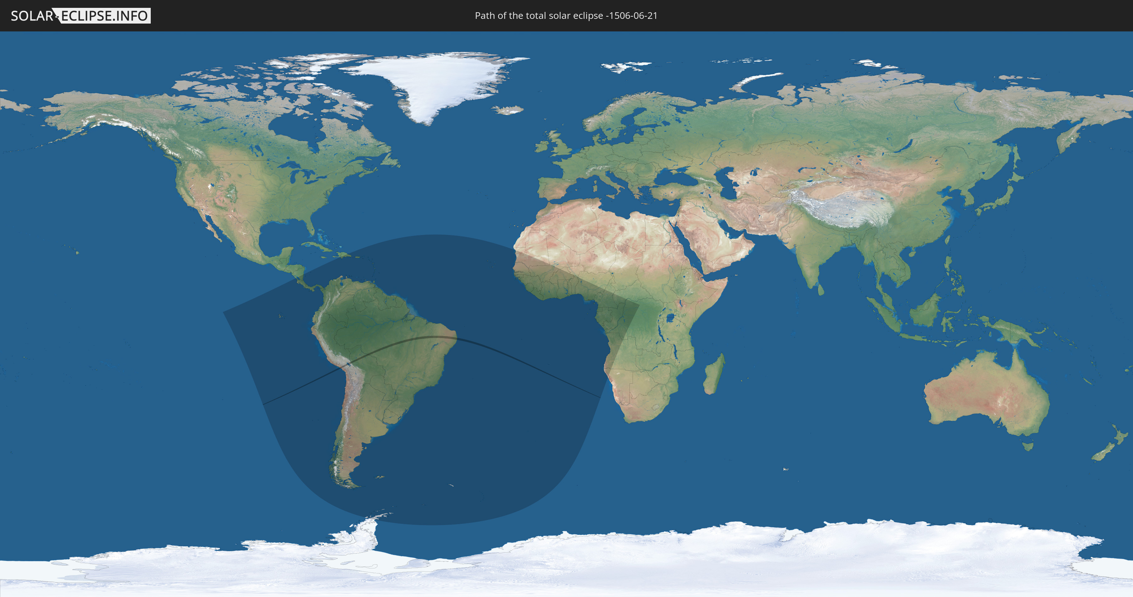
Die Sonnenfinsternis am 21.06.-1506 kann man in 65 Ländern als partielle Sonnenfinsternis beobachten.
Der Finsternispfad verläuft durch 3 Länder. Nur in diesen Ländern ist sie als totale Sonnenfinsternis zu sehen.
In den folgenden Ländern ist die Sonnenfinsternis total zu sehen
 Peru
Peru
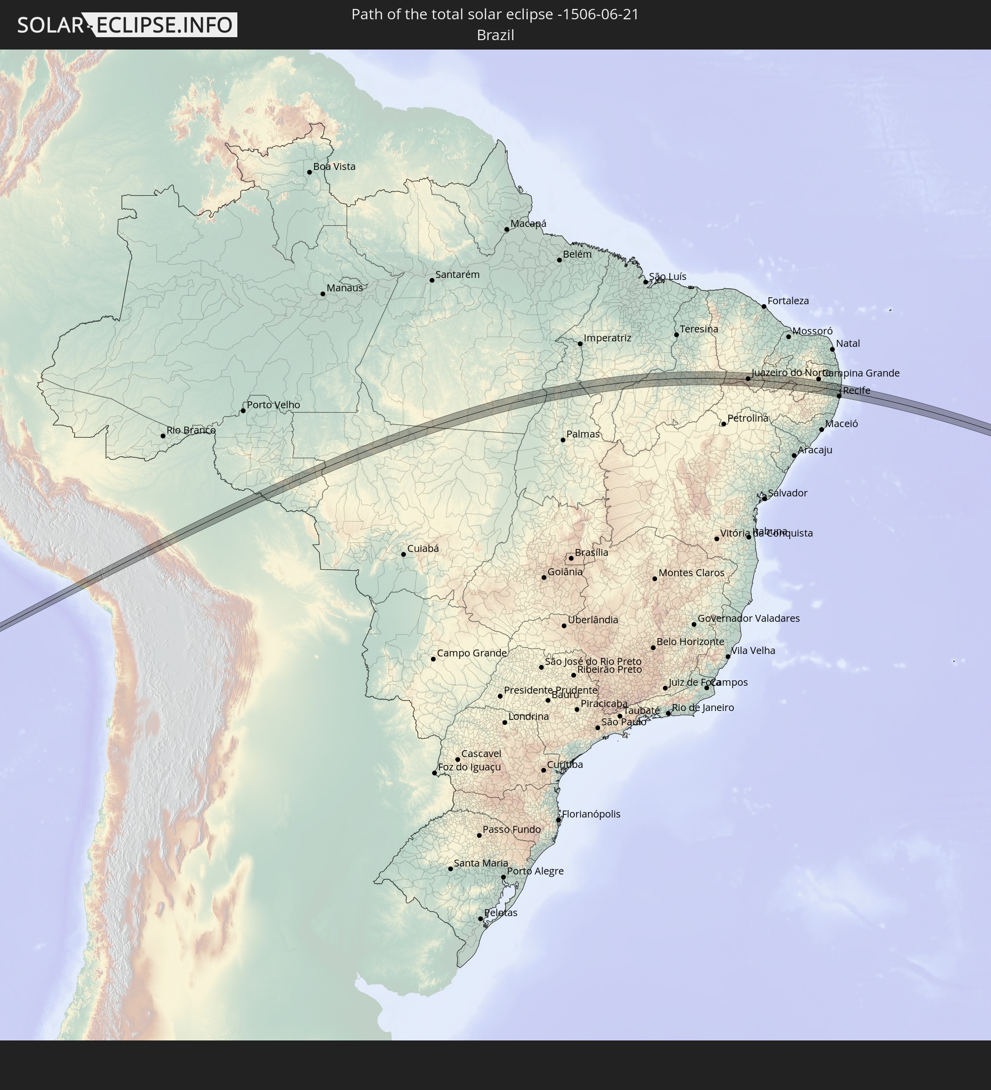 Brasilien
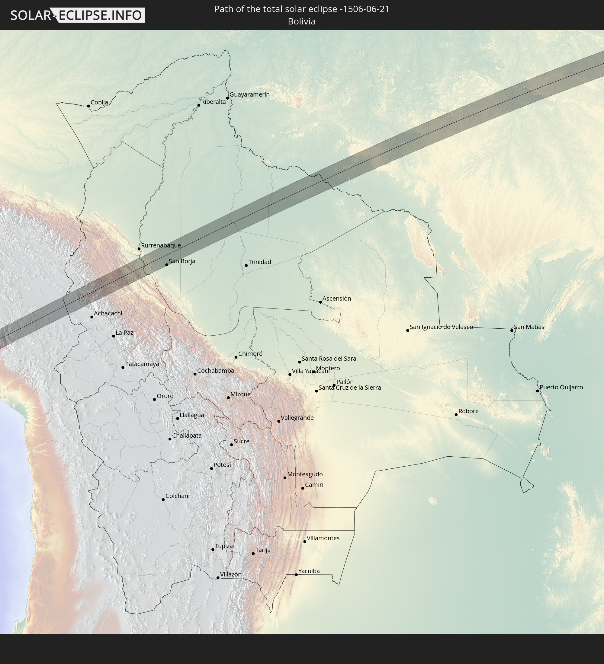 Bolivien
In den folgenden Ländern ist die Sonnenfinsternis partiell zu sehen
 Antarktika
 Chile
Chile
 Ecuador
 Nicaragua
 Costa Rica
 Panama
 Kolumbien
 Peru
Peru
 Haiti
Haiti
 Brasilien
 Argentinien
 Venezuela
 Dominikanische Republik
 Aruba
Aruba
 Bolivien
 Puerto Rico
 Amerikanische Jungferninseln
 Britische Jungferninseln
 Anguilla
 Saint-Martin
 Saint-Barthélemy
 St. Kitts und Nevis
 Paraguay
 Antigua und Barbuda
 Montserrat
 Trinidad und Tobago
 Guadeloupe
 Grenada
 Dominica
 St. Vincent und die Grenadinen
 Falklandinseln
 Guyana
 Martinique
 St. Lucia
 Barbados
 Uruguay
 Suriname
 Französisch-Guayana
 Südgeorgien und die Südlichen Sandwichinseln
 Kap Verde
 Senegal
 Mauretanien
 Gambia
 Guinea-Bissau
 Guinea
 St. Helena
 Sierra Leone
 Mali
Mali
 Liberia
 Elfenbeinküste
 Burkina Faso
 Ghana
Ghana
 Togo
Togo
 Niger
Niger
 Benin
Benin
 Nigeria
 Äquatorialguinea
 São Tomé und Príncipe
 Kamerun
 Gabun
Gabun
 Republik Kongo
 Angola
 Namibia
 Demokratische Republik Kongo
 Zentralafrikanische Republik
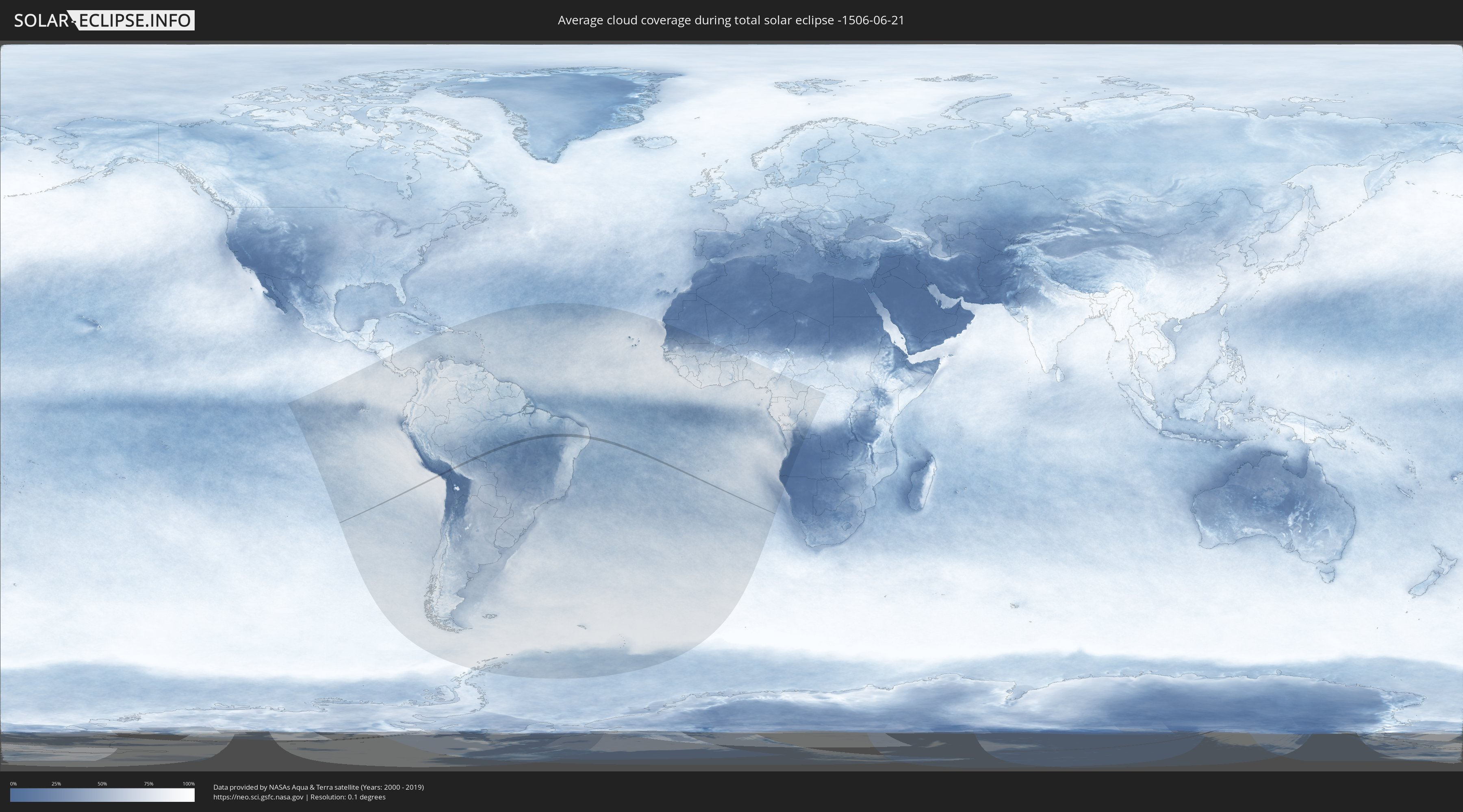
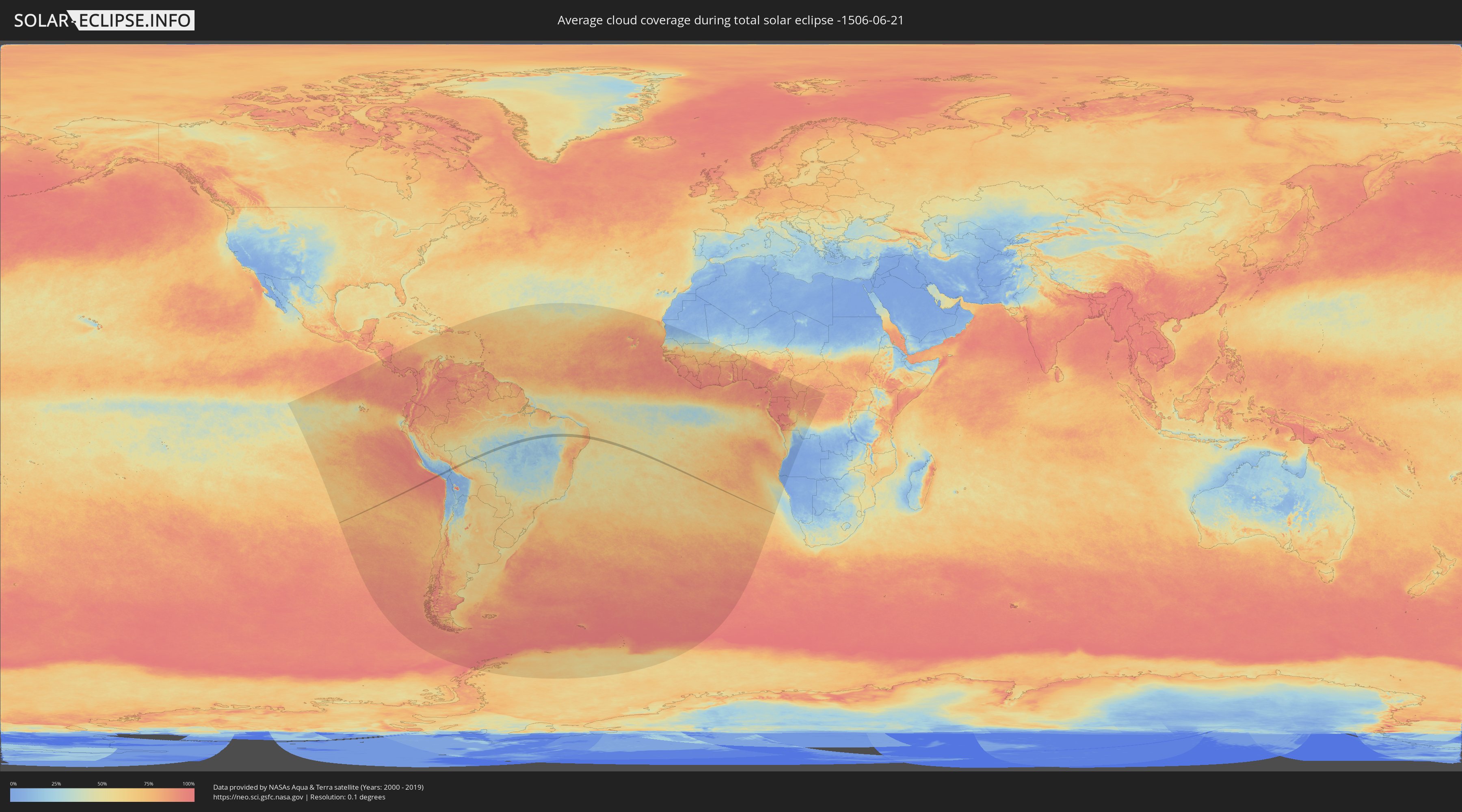
Wie wird das Wetter während der totalen Sonnenfinsternis am 21.06.-1506?
Wo ist der beste Ort, um die totale Sonnenfinsternis vom 21.06.-1506 zu beobachten?
Die folgenden Karten zeigen die durchschnittliche Bewölkung für den Tag, an dem die totale Sonnenfinsternis
stattfindet. Mit Hilfe der Karten lässt sich der Ort entlang des Finsternispfades eingrenzen,
der die besten Aussichen auf einen klaren wolkenfreien Himmel bietet.
Trotzdem muss man immer lokale Gegenenheiten beachten und sollte sich genau über das Wetter an seinem
gewählten Beobachtungsort informieren.
Die Daten stammen von den beiden NASA-Satelliten
AQUA und TERRA
und wurden über einen Zeitraum von 19 Jahren (2000 - 2019) gemittelt.
Detaillierte Länderkarten
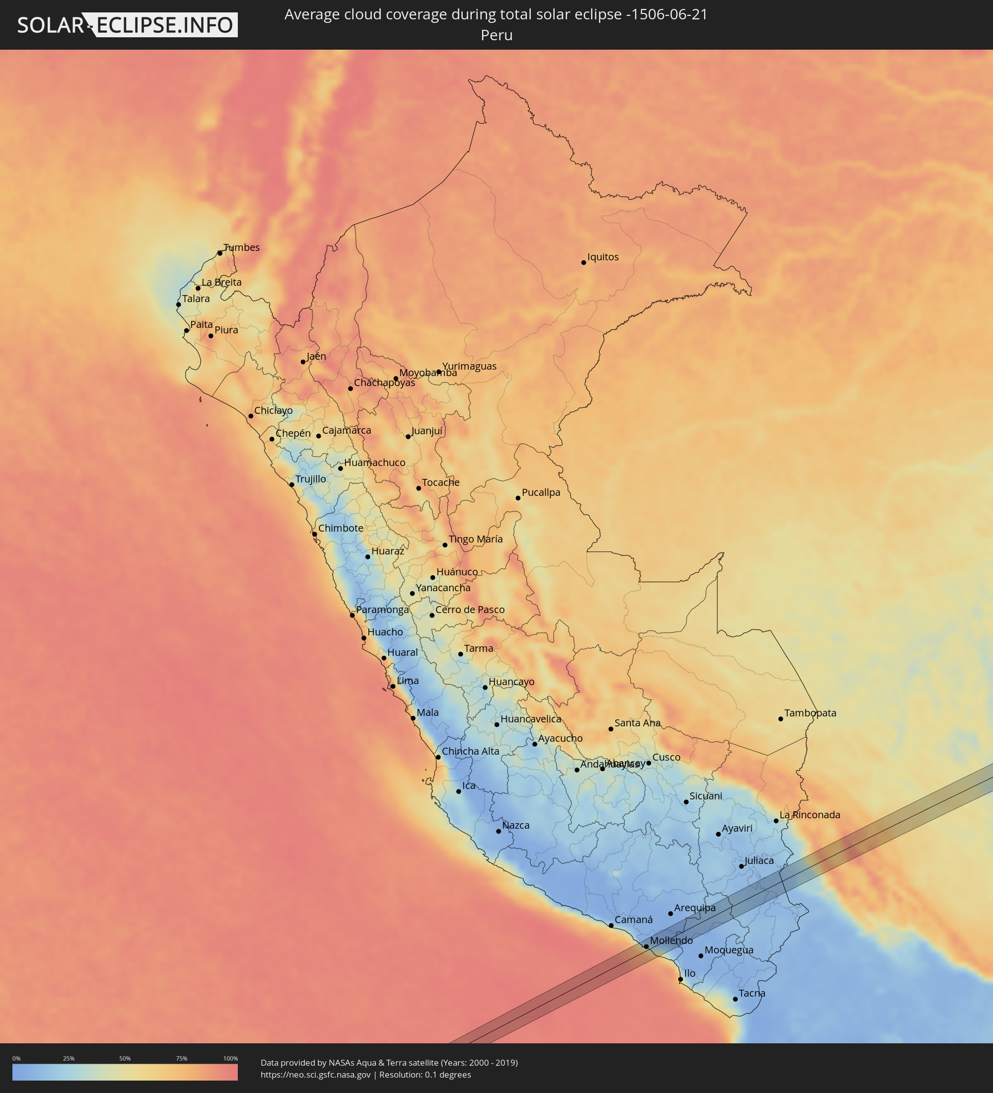 Peru
Peru
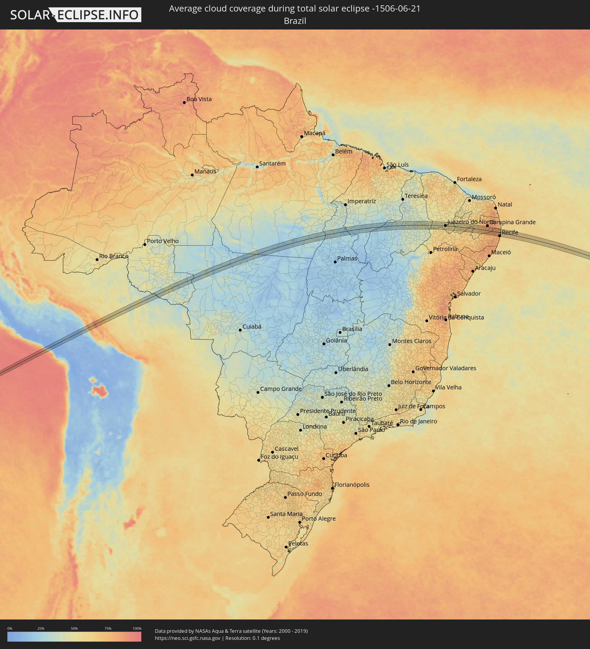 Brasilien
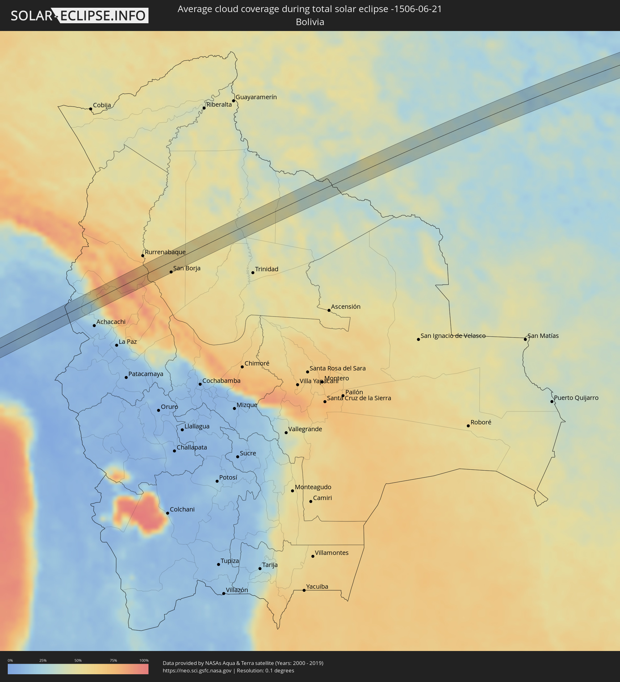 Bolivien
Orte im Finsternispfad
Die nachfolgene Tabelle zeigt Städte und Orte mit mehr als 5.000 Einwohnern, die sich im Finsternispfad befinden. Städte mit mehr als 100.000 Einwohnern sind dick gekennzeichnet. Mit einem Klick auf den Ort öffnet sich eine Detailkarte die die Lage des jeweiligen Ortes zusammen mit dem Verlauf der zentralen Finsternis präsentiert.
| Ort | Typ | Dauer der Verfinsterung | Ortszeit bei maximaler Verfinsterung | Entfernung zur Zentrallinie | Ø Bewölkung |
|
Mollendo, Arequipa
|
total | - | 08:17:25 UTC-05:08 | 6 km | 72% |
|
Punta de Bombón, Arequipa
|
total | - | 08:17:46 UTC-05:08 | 20 km | 82% |
|
Cocachacra, Arequipa
|
total | - | 08:17:49 UTC-05:08 | 13 km | 77% |
|
Ilave, Puno
|
total | - | 08:21:04 UTC-05:08 | 15 km | 10% |
|
San Borja, El Beni
|
total | - | 09:02:04 UTC-04:32 | 25 km | 59% |
|
Conceição do Araguaia, Pará
|
total | - | 11:08:34 UTC-03:13 | 30 km | 24% |
|
Carolina, Maranhão
|
total | - | 11:54:53 UTC-02:34 | 34 km | 24% |
|
Santa Luzia, Maranhão
|
total | - | 11:55:41 UTC-02:34 | 4 km | 21% |
|
Riachão, Maranhão
|
total | - | 11:57:50 UTC-02:34 | 17 km | 22% |
|
Balsas, Maranhão
|
total | - | 11:59:50 UTC-02:34 | 10 km | 29% |
|
Uruçuí, Piauí
|
total | - | 12:05:08 UTC-02:34 | 6 km | 23% |
|
Oeiras, Piauí
|
total | - | 12:13:50 UTC-02:34 | 15 km | 36% |
|
Picos, Piauí
|
total | - | 12:16:12 UTC-02:34 | 9 km | 42% |
|
Jaicós, Piauí
|
total | - | 12:17:22 UTC-02:34 | 23 km | 40% |
|
Ipueiras, Ceará
|
total | - | 12:19:50 UTC-02:34 | 15 km | 44% |
|
Campos Sales, Ceará
|
total | - | 12:20:06 UTC-02:34 | 11 km | 44% |
|
Araripe, Ceará
|
total | - | 12:21:16 UTC-02:34 | 3 km | 45% |
|
Assaré, Ceará
|
total | - | 12:21:53 UTC-02:34 | 35 km | 47% |
|
Exu, Pernambuco
|
total | - | 12:36:47 UTC-02:19 | 35 km | 60% |
|
Farias Brito, Ceará
|
total | - | 12:22:59 UTC-02:34 | 31 km | 51% |
|
Crato, Ceará
|
total | - | 12:23:31 UTC-02:34 | 2 km | 55% |
|
Juazeiro do Norte, Ceará
|
total | - | 12:23:51 UTC-02:34 | 1 km | 52% |
|
Barbalha, Ceará
|
total | - | 12:23:53 UTC-02:34 | 10 km | 51% |
|
Caririaçu, Ceará
|
total | - | 12:23:58 UTC-02:34 | 20 km | 54% |
|
Missão Velha, Ceará
|
total | - | 12:24:27 UTC-02:34 | 2 km | 53% |
|
Brejo Santo, Ceará
|
total | - | 12:25:00 UTC-02:34 | 28 km | 58% |
|
Aurora, Ceará
|
total | - | 12:25:05 UTC-02:34 | 34 km | 56% |
|
Milagres, Ceará
|
total | - | 12:25:09 UTC-02:34 | 7 km | 55% |
|
São José de Piranhas, Paraíba
|
total | - | 12:26:43 UTC-02:34 | 18 km | 53% |
|
Itaporanga, Paraíba
|
total | - | 12:27:56 UTC-02:34 | 1 km | 58% |
|
Piancó, Paraíba
|
total | - | 12:28:43 UTC-02:34 | 15 km | 59% |
|
Tabira, Pernambuco
|
total | - | 12:44:27 UTC-02:19 | 24 km | 66% |
|
São José do Egito, Pernambuco
|
total | - | 12:45:22 UTC-02:19 | 8 km | 61% |
|
Teixeira, Paraíba
|
total | - | 12:31:03 UTC-02:34 | 21 km | 60% |
|
Desterro, Paraíba
|
total | - | 12:31:36 UTC-02:34 | 15 km | 65% |
|
Sumé, Paraíba
|
total | - | 12:32:20 UTC-02:34 | 24 km | 65% |
|
Taperoá, Paraíba
|
total | - | 12:32:31 UTC-02:34 | 28 km | 66% |
|
Boqueirão, Paraíba
|
total | - | 12:34:52 UTC-02:34 | 8 km | 76% |
|
Fagundes, Paraíba
|
total | - | 12:36:05 UTC-02:34 | 28 km | 79% |
|
Surubim, Pernambuco
|
total | - | 12:50:34 UTC-02:19 | 24 km | 79% |
|
Aroeiras, Paraíba
|
total | - | 12:36:19 UTC-02:34 | 8 km | 80% |
|
Orobó, Pernambuco
|
total | - | 12:51:04 UTC-02:19 | 12 km | 81% |
|
João Alfredo, Pernambuco
|
total | - | 12:51:07 UTC-02:19 | 24 km | 77% |
|
Bom Jardim, Pernambuco
|
total | - | 12:51:07 UTC-02:19 | 17 km | 79% |
|
Macaparana, Pernambuco
|
total | - | 12:51:34 UTC-02:19 | 12 km | 81% |
|
Limoeiro, Pernambuco
|
total | - | 12:51:35 UTC-02:19 | 23 km | 77% |
|
Feira Nova, Pernambuco
|
total | - | 12:51:47 UTC-02:19 | 30 km | 77% |
|
Vicência, Pernambuco
|
total | - | 12:52:00 UTC-02:19 | 3 km | 81% |
|
Timbaúba, Pernambuco
|
total | - | 12:52:01 UTC-02:19 | 20 km | 81% |
|
Lagoa do Itaenga, Pernambuco
|
total | - | 12:52:07 UTC-02:19 | 27 km | 79% |
|
Carpina, Pernambuco
|
total | - | 12:52:14 UTC-02:19 | 17 km | 79% |
|
Nazaré da Mata, Pernambuco
|
total | - | 12:52:19 UTC-02:19 | 5 km | 79% |
|
Condado, Pernambuco
|
total | - | 12:52:44 UTC-02:19 | 15 km | 78% |
|
Itaquitinga, Pernambuco
|
total | - | 12:52:45 UTC-02:19 | 6 km | 79% |
|
Araçoiaba, Pernambuco
|
total | - | 12:52:47 UTC-02:19 | 7 km | 81% |
|
São Lourenço da Mata, Pernambuco
|
total | - | 12:53:02 UTC-02:19 | 29 km | 80% |
|
Goiana, Pernambuco
|
total | - | 12:53:04 UTC-02:19 | 20 km | 78% |
|
Caaporã, Paraíba
|
total | - | 12:38:59 UTC-02:34 | 26 km | 69% |
|
Igarassu, Pernambuco
|
total | - | 12:53:24 UTC-02:19 | 9 km | 71% |
|
Abreu e Lima, Pernambuco
|
total | - | 12:53:24 UTC-02:19 | 17 km | 72% |
|
Itapissuma, Pernambuco
|
total | - | 12:53:26 UTC-02:19 | 2 km | 71% |
|
Recife, Pernambuco
|
total | - | 12:53:29 UTC-02:19 | 32 km | 64% |
|
Paulista, Pernambuco
|
total | - | 12:53:30 UTC-02:19 | 20 km | 72% |
|
Olinda, Pernambuco
|
total | - | 12:53:34 UTC-02:19 | 27 km | 68% |
|
Itamaracá, Pernambuco
|
total | - | 12:53:40 UTC-02:19 | 3 km | 58% |
|
Pitimbu, Paraíba
|
total | - | 12:39:18 UTC-02:34 | 33 km | 57% |