Totale Sonnenfinsternis vom 21.02.-1807
| Wochentag: | Dienstag |
| Maximale Dauer der Verfinsterung: | 05m31s |
| Maximale Breite des Finsternispfades: | 214 km |
| Saroszyklus: | 11 |
| Bedeckungsgrad: | 100% |
| Magnitude: | 1.0654 |
| Gamma: | 0.0323 |
Wo kann man die Sonnenfinsternis vom 21.02.-1807 sehen?
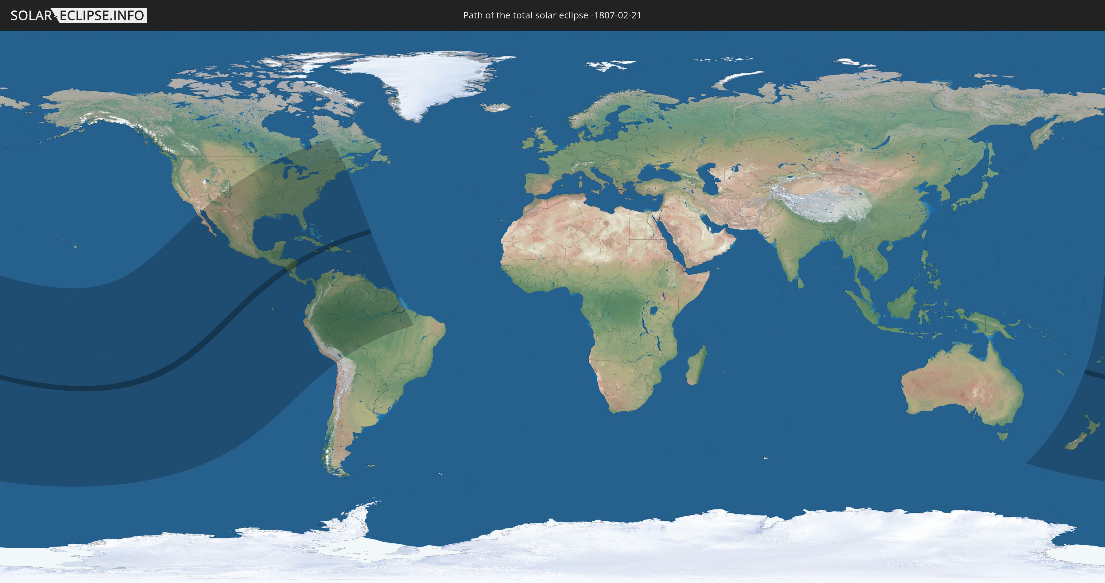
Die Sonnenfinsternis am 21.02.-1807 kann man in 60 Ländern als partielle Sonnenfinsternis beobachten.
Der Finsternispfad verläuft durch 8 Länder. Nur in diesen Ländern ist sie als totale Sonnenfinsternis zu sehen.
In den folgenden Ländern ist die Sonnenfinsternis total zu sehen
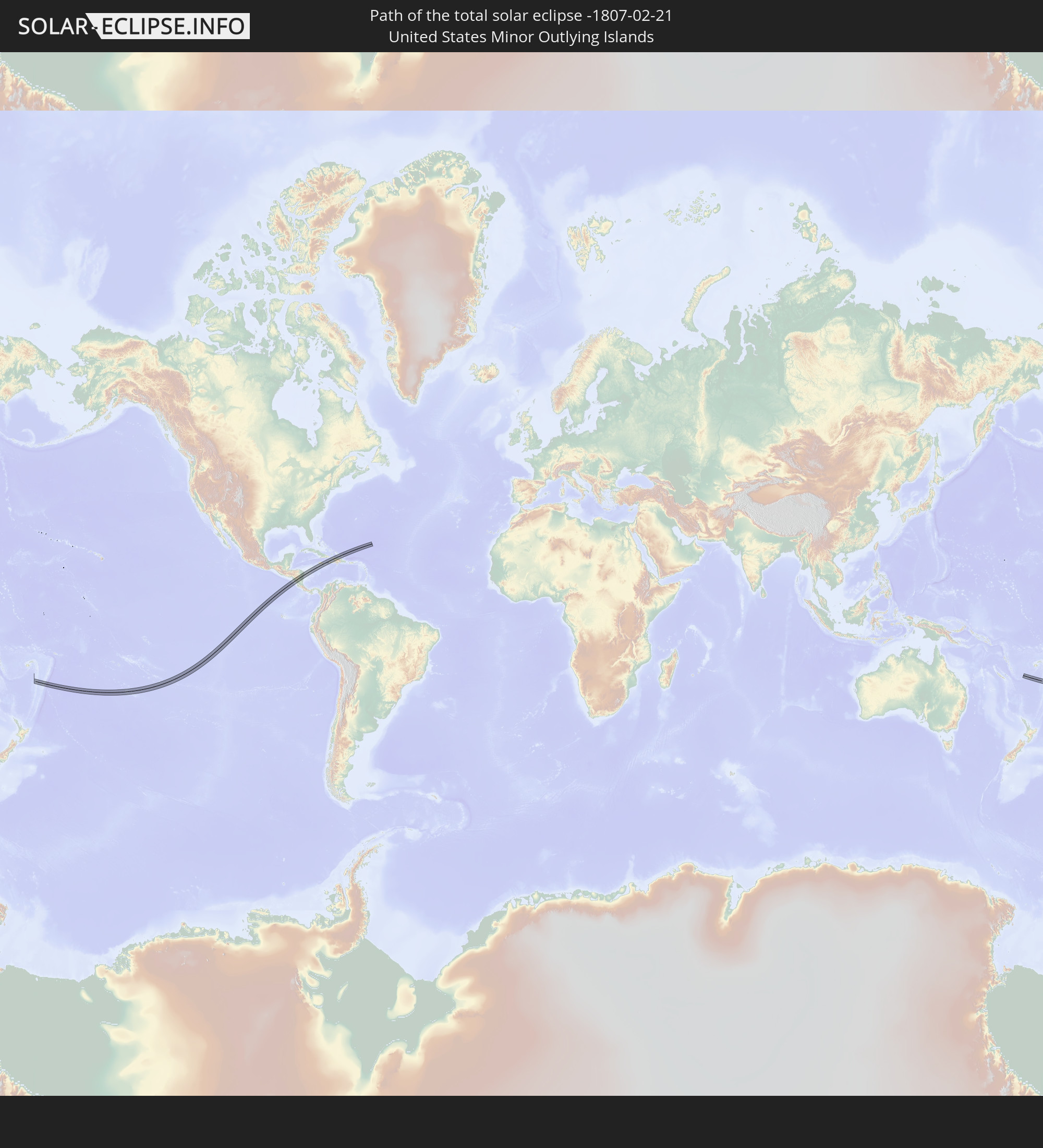 United States Minor Outlying Islands
 Französisch-Polynesien
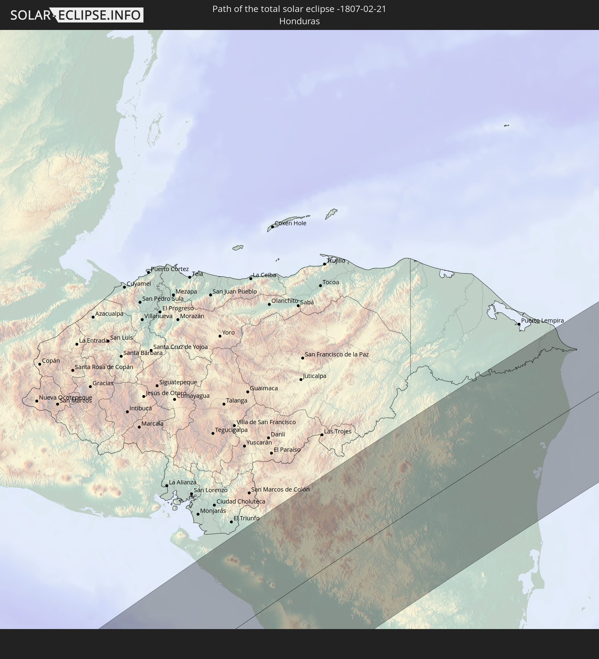 Honduras
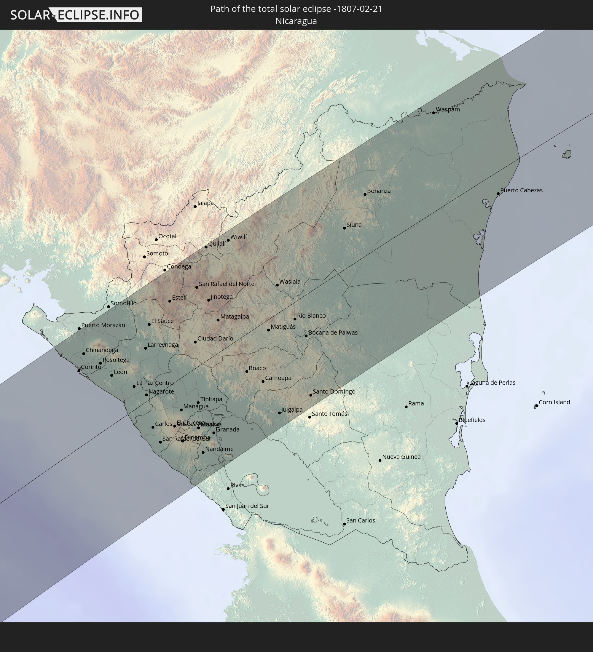 Nicaragua
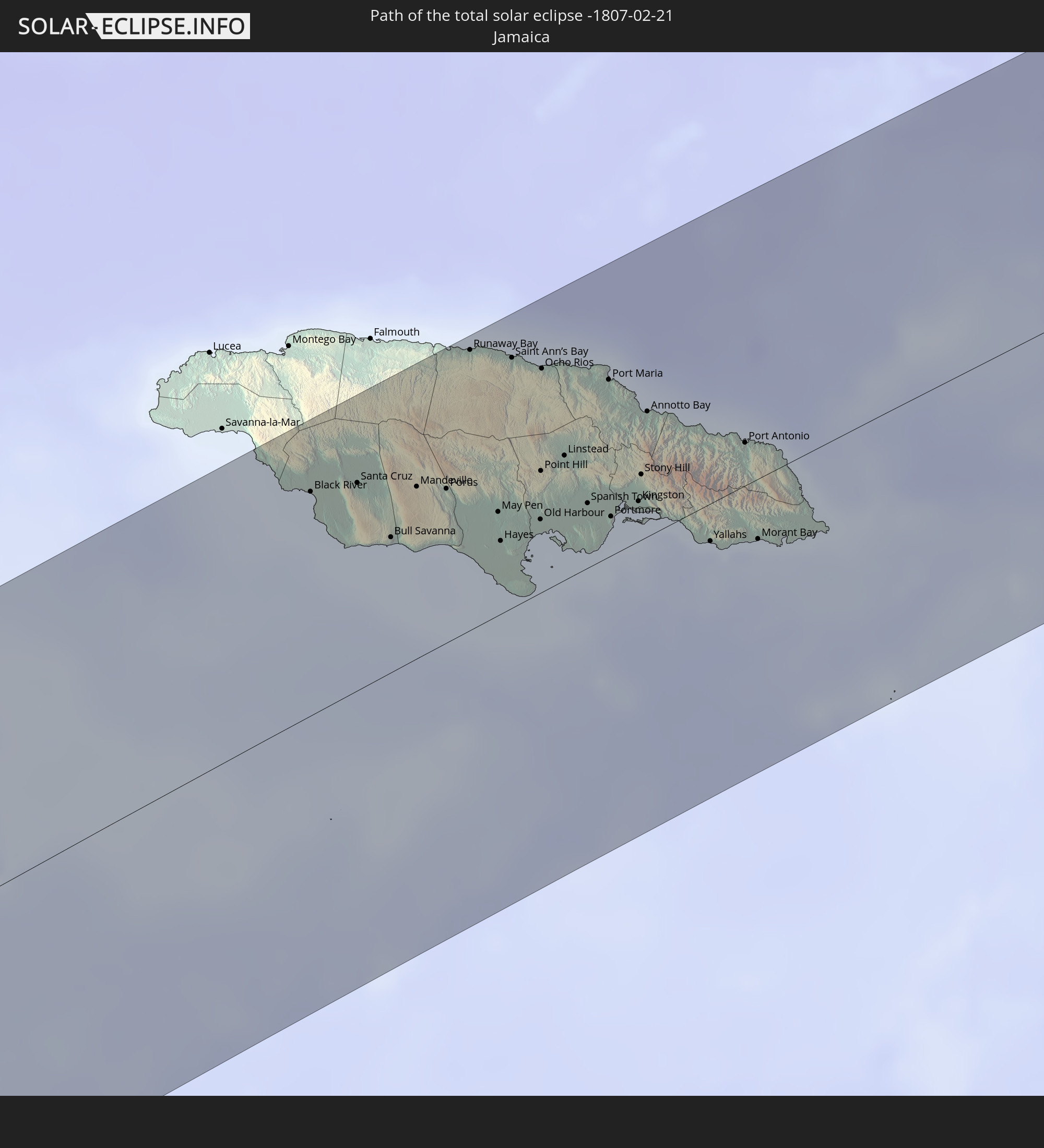 Jamaika
 Haiti
Haiti
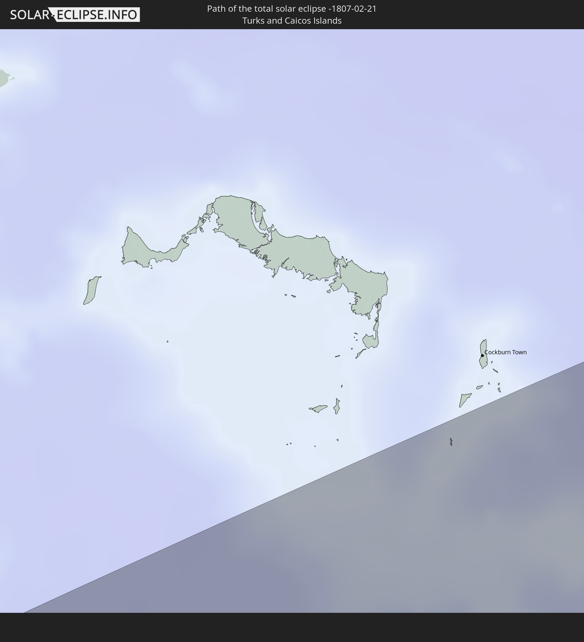 Turks- und Caicosinseln
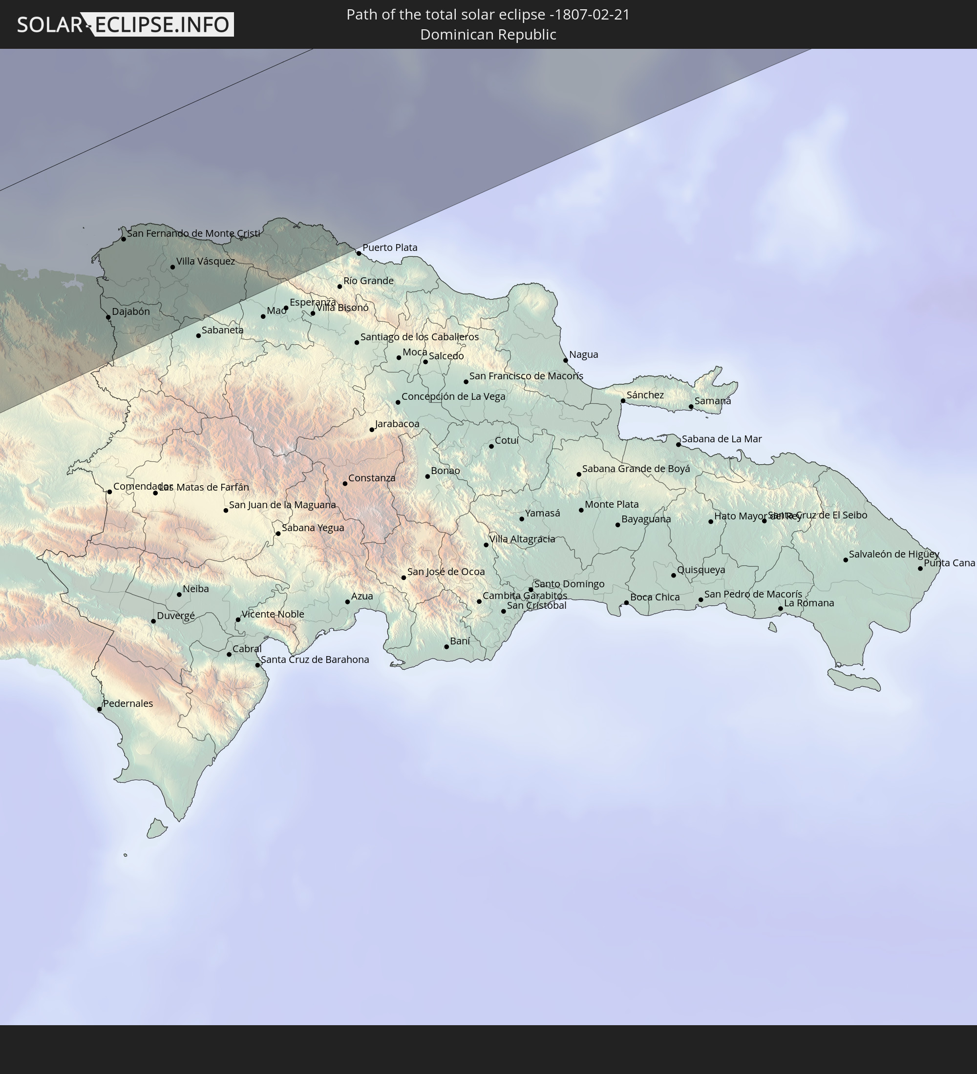 Dominikanische Republik
In den folgenden Ländern ist die Sonnenfinsternis partiell zu sehen
 Fidschi
 Vereinigte Staaten
 Neuseeland
 United States Minor Outlying Islands
 Wallis und Futuna
 Tonga
Tonga
 Kiribati
 Samoa
Samoa
 Tokelau
 Amerikanisch-Samoa
 Niue
Niue
 Cookinseln
 Französisch-Polynesien
 Kanada
 Pitcairninseln
 Mexiko
 Chile
Chile
 Guatemala
 Ecuador
 El Salvador
 Honduras
 Belize
 Nicaragua
 Costa Rica
 Kuba
Kuba
 Panama
 Kolumbien
 Kaimaninseln
 Peru
Peru
 Bahamas
 Jamaika
 Haiti
Haiti
 Brasilien
 Venezuela
 Turks- und Caicosinseln
 Dominikanische Republik
 Aruba
Aruba
 Bolivien
 Puerto Rico
 Amerikanische Jungferninseln
 Bermuda
 Britische Jungferninseln
 Anguilla
 Saint-Martin
 Saint-Barthélemy
 St. Kitts und Nevis
 Antigua und Barbuda
 Montserrat
 Trinidad und Tobago
 Guadeloupe
 Grenada
 Dominica
 St. Vincent und die Grenadinen
 Guyana
 Martinique
 St. Lucia
 Barbados
 Suriname
 Französisch-Guayana
 Tuvalu
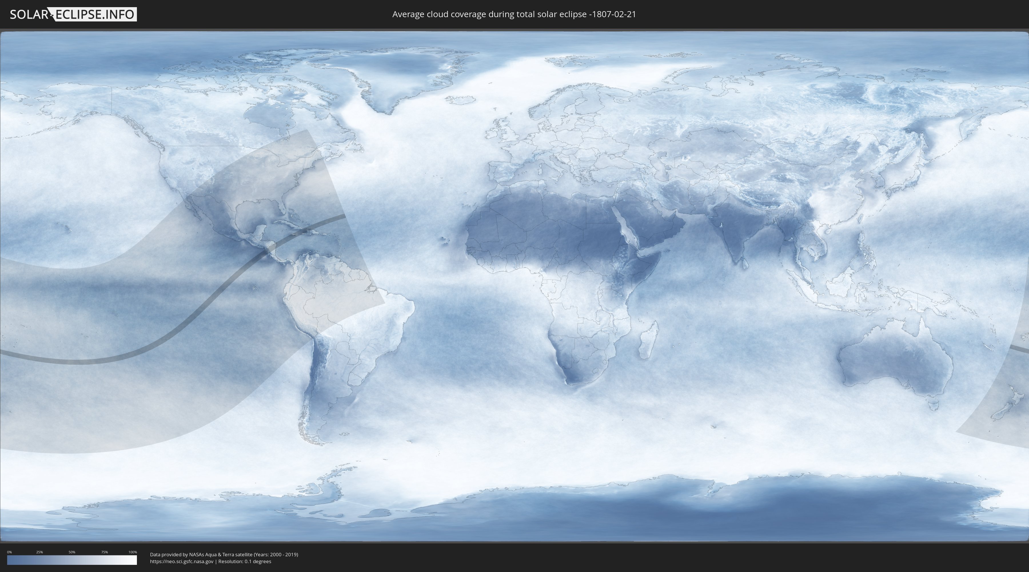
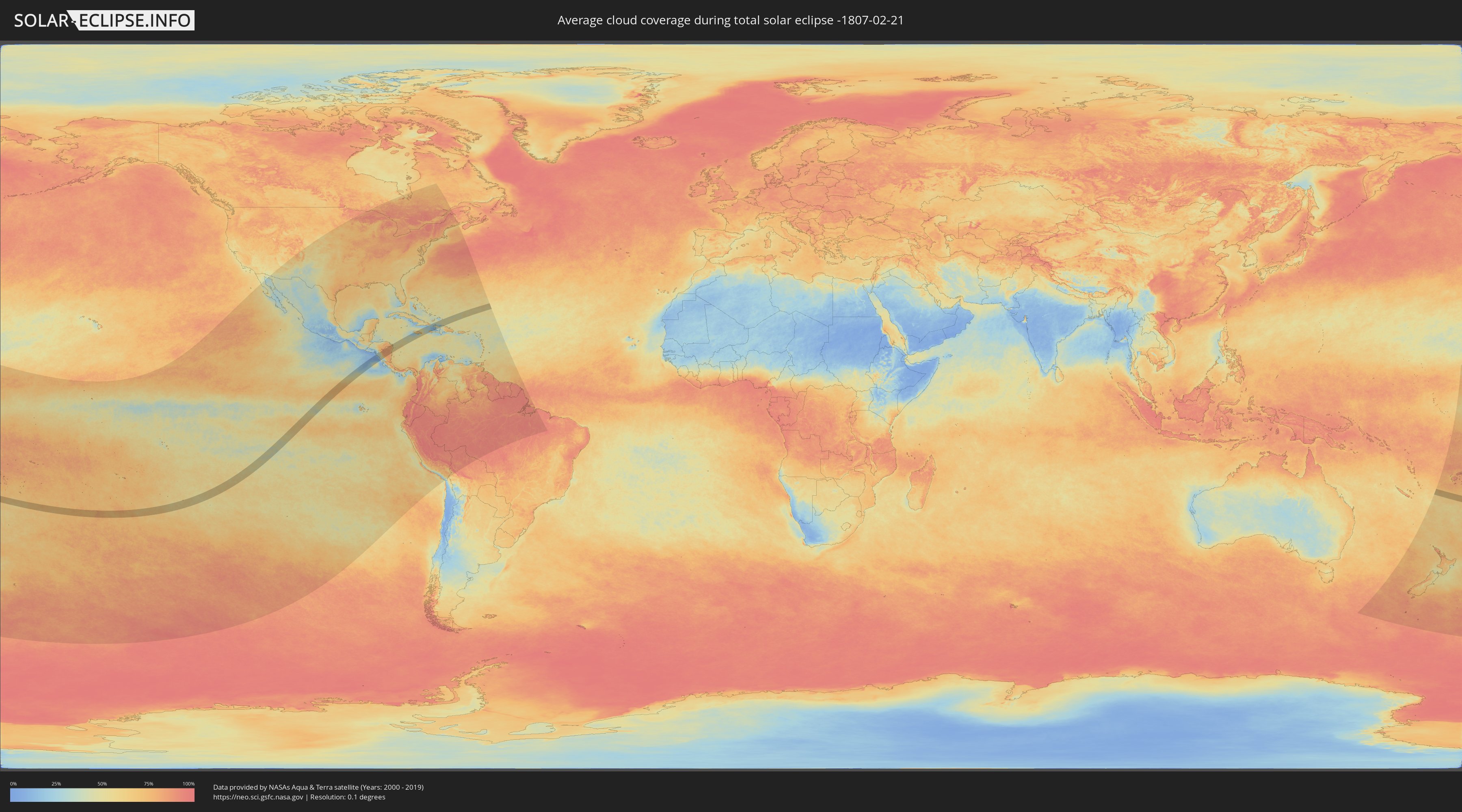
Wie wird das Wetter während der totalen Sonnenfinsternis am 21.02.-1807?
Wo ist der beste Ort, um die totale Sonnenfinsternis vom 21.02.-1807 zu beobachten?
Die folgenden Karten zeigen die durchschnittliche Bewölkung für den Tag, an dem die totale Sonnenfinsternis
stattfindet. Mit Hilfe der Karten lässt sich der Ort entlang des Finsternispfades eingrenzen,
der die besten Aussichen auf einen klaren wolkenfreien Himmel bietet.
Trotzdem muss man immer lokale Gegenenheiten beachten und sollte sich genau über das Wetter an seinem
gewählten Beobachtungsort informieren.
Die Daten stammen von den beiden NASA-Satelliten
AQUA und TERRA
und wurden über einen Zeitraum von 19 Jahren (2000 - 2019) gemittelt.
Detaillierte Länderkarten
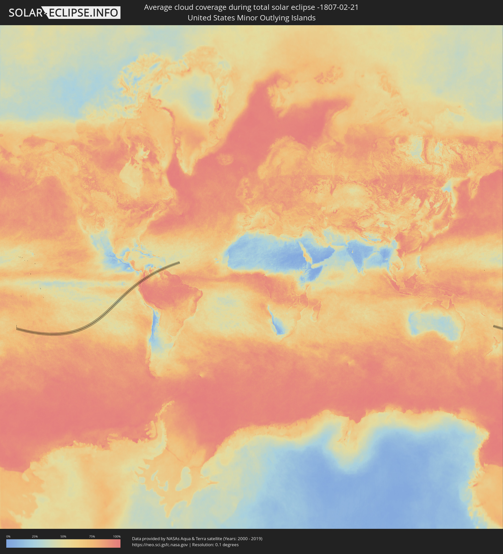 United States Minor Outlying Islands
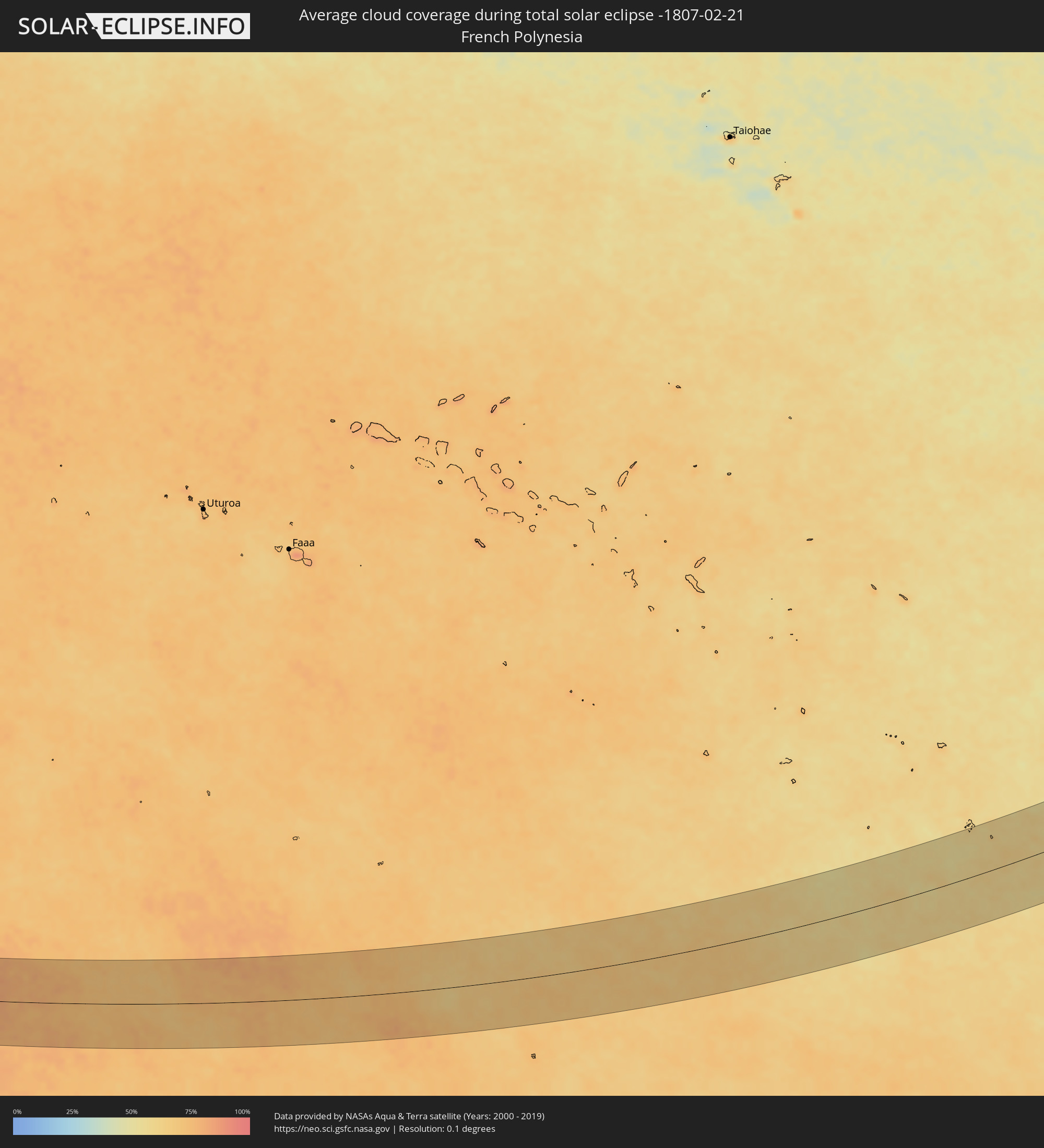 Französisch-Polynesien
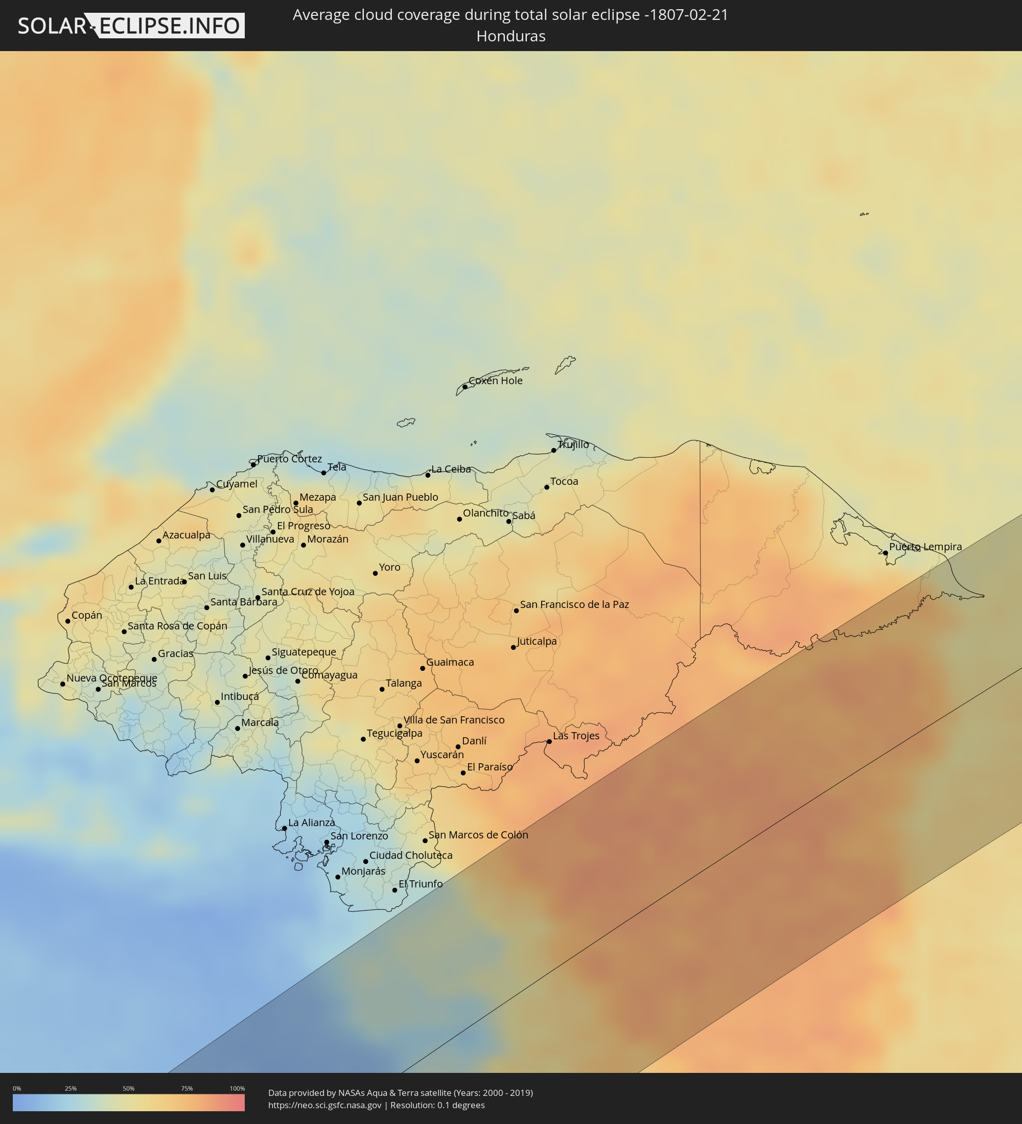 Honduras
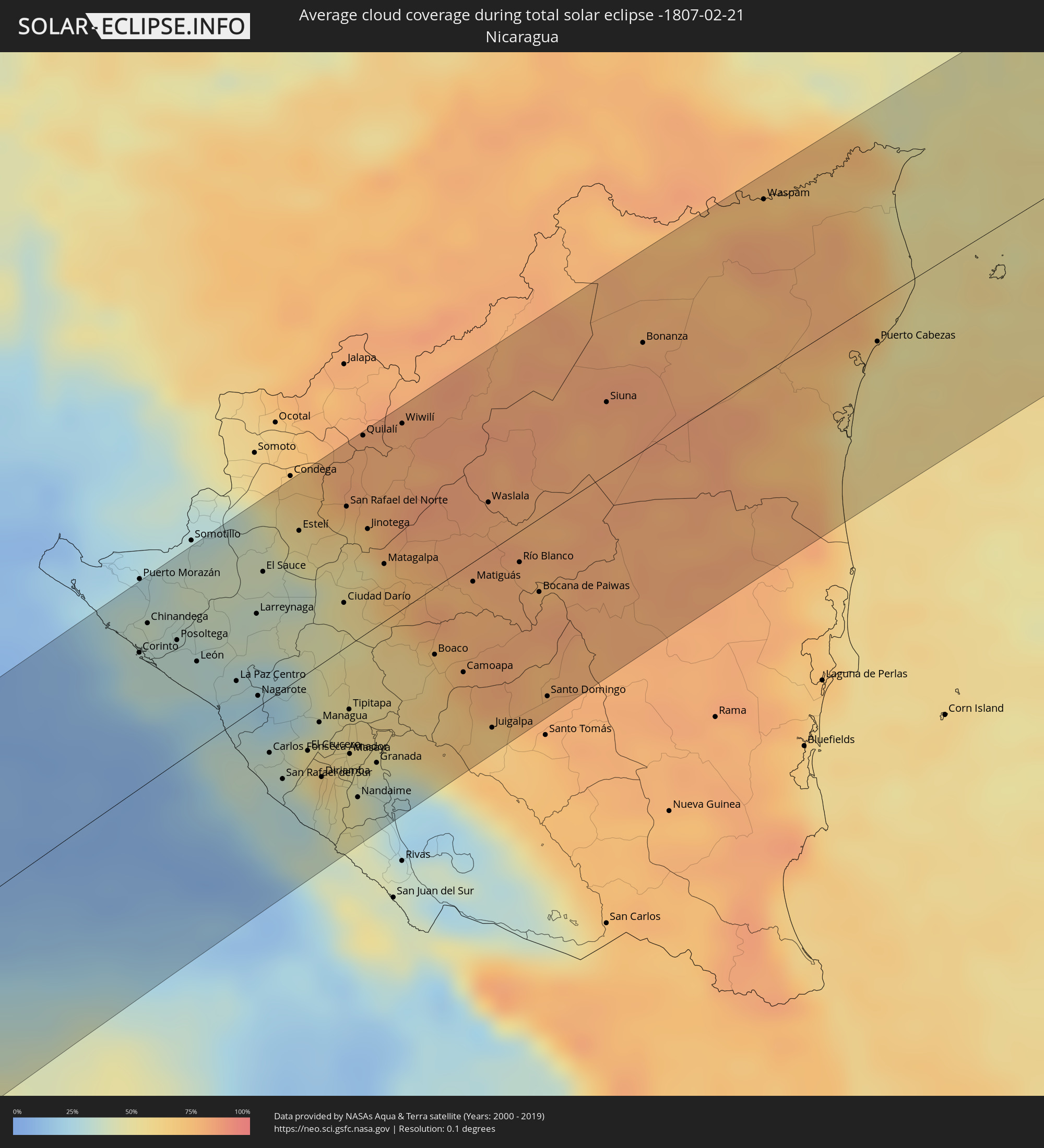 Nicaragua
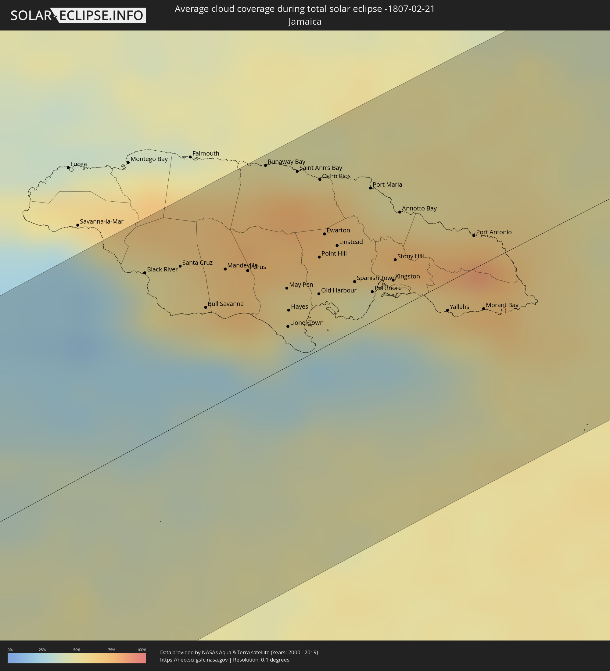 Jamaika
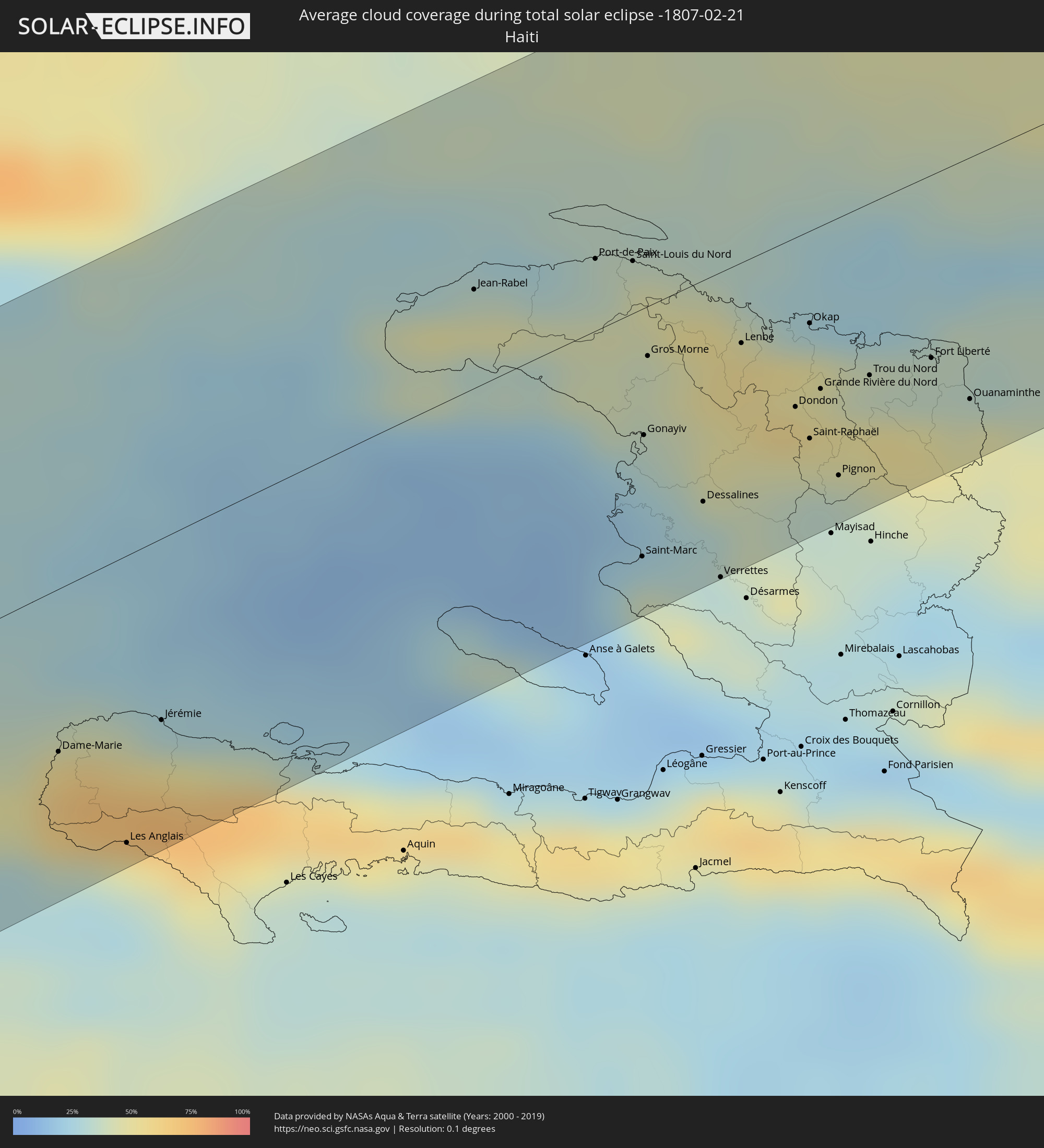 Haiti
Haiti
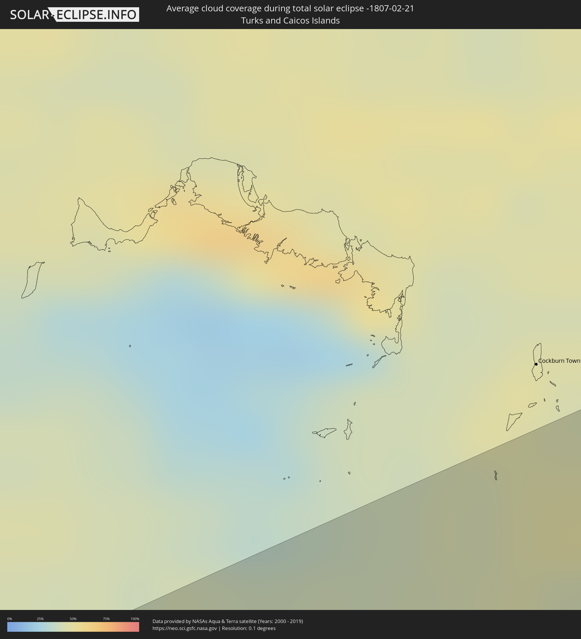 Turks- und Caicosinseln
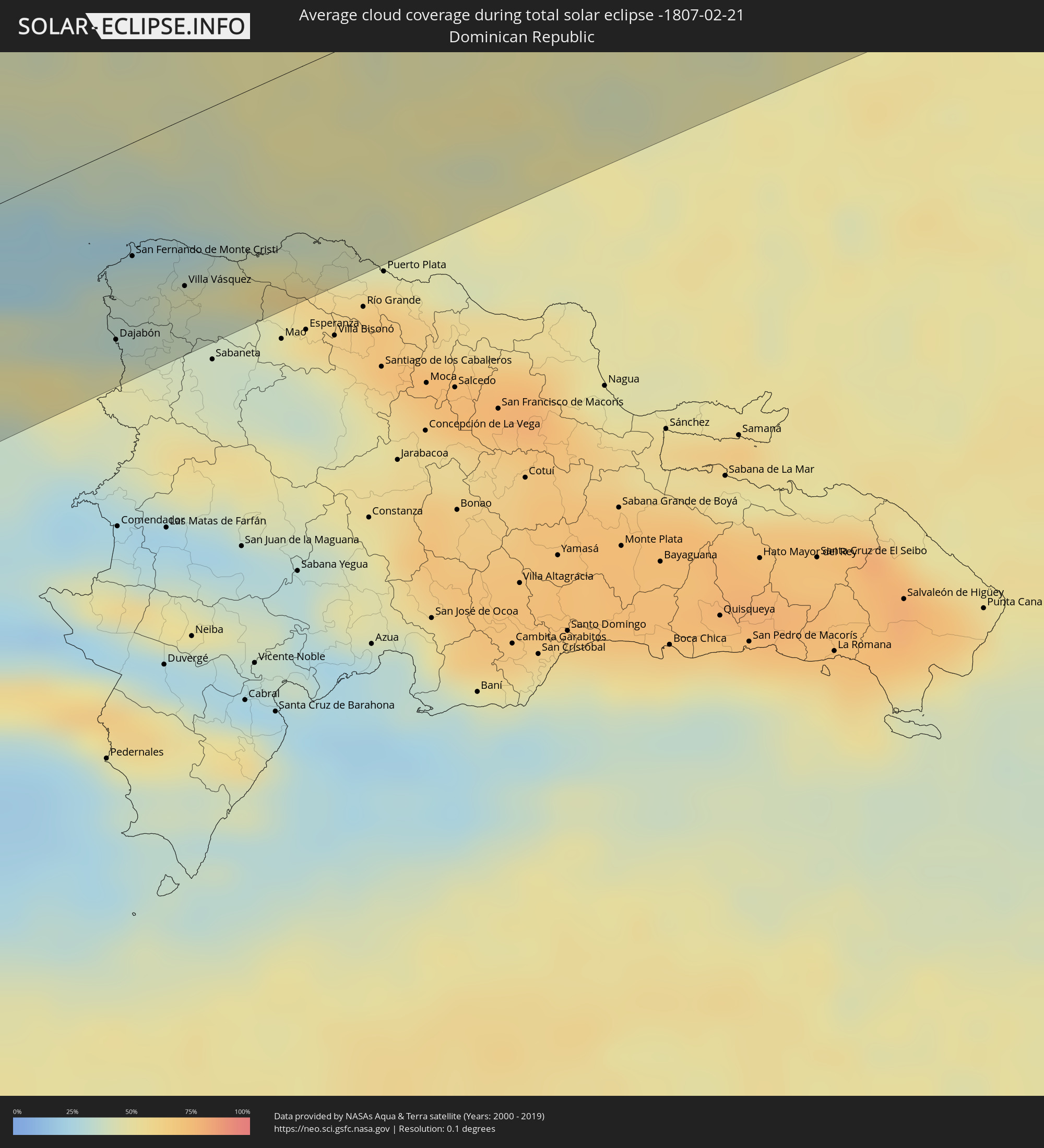 Dominikanische Republik
Orte im Finsternispfad
Die nachfolgene Tabelle zeigt Städte und Orte mit mehr als 5.000 Einwohnern, die sich im Finsternispfad befinden. Städte mit mehr als 100.000 Einwohnern sind dick gekennzeichnet. Mit einem Klick auf den Ort öffnet sich eine Detailkarte die die Lage des jeweiligen Ortes zusammen mit dem Verlauf der zentralen Finsternis präsentiert.
| Ort | Typ | Dauer der Verfinsterung | Ortszeit bei maximaler Verfinsterung | Entfernung zur Zentrallinie | Ø Bewölkung |
|
Corinto, Chinandega
|
total | - | 15:45:36 UTC-05:45 | 62 km | 31% |
|
El Viejo, Chinandega
|
total | - | 15:45:47 UTC-05:45 | 79 km | 35% |
|
El Realejo, Chinandega
|
total | - | 15:45:40 UTC-05:45 | 67 km | 31% |
|
Chinandega, Chinandega
|
total | - | 15:45:46 UTC-05:45 | 73 km | 33% |
|
Chichigalpa, Chinandega
|
total | - | 15:45:48 UTC-05:45 | 62 km | 33% |
|
Posoltega, Chinandega
|
total | - | 15:45:49 UTC-05:45 | 56 km | 32% |
|
León, León
|
total | - | 15:45:48 UTC-05:45 | 40 km | 24% |
|
Telica, León
|
total | - | 15:45:53 UTC-05:45 | 47 km | 32% |
|
La Paz Centro, León
|
total | - | 15:45:52 UTC-05:45 | 19 km | 28% |
|
Larreynaga, León
|
total | - | 15:46:15 UTC-05:45 | 43 km | 36% |
|
Nagarote, León
|
total | - | 15:45:53 UTC-05:45 | 5 km | 28% |
|
El Sauce, León
|
total | - | 15:46:28 UTC-05:45 | 61 km | 39% |
|
San Rafael del Sur, Managua
|
total | - | 15:45:36 UTC-05:45 | 41 km | 29% |
|
Estelí, Estelí
|
total | - | 15:46:48 UTC-05:45 | 68 km | 50% |
|
Ciudad Sandino, Managua
|
total | - | 15:45:58 UTC-05:45 | 18 km | 49% |
|
El Crucero, Managua
|
total | - | 15:45:50 UTC-05:45 | 36 km | 47% |
|
Managua, Managua
|
total | - | 15:46:00 UTC-05:45 | 27 km | 53% |
|
Diriamba, Carazo
|
total | - | 15:45:46 UTC-05:45 | 53 km | 46% |
|
Dolores, Carazo
|
total | - | 15:45:47 UTC-05:45 | 54 km | 46% |
|
Ticuantepe, Managua
|
total | - | 15:45:56 UTC-05:45 | 39 km | 61% |
|
San Marcos, Carazo
|
total | - | 15:45:50 UTC-05:45 | 50 km | 46% |
|
Jinotepe, Carazo
|
total | - | 15:45:47 UTC-05:45 | 56 km | 40% |
|
La Concepción, Masaya
|
total | - | 15:45:52 UTC-05:45 | 48 km | 46% |
|
Masatepe, Masaya
|
total | - | 15:45:53 UTC-05:45 | 53 km | 52% |
|
Ciudad Darío, Matagalpa
|
total | - | 15:46:39 UTC-05:45 | 21 km | 52% |
|
Nindirí, Masaya
|
total | - | 15:45:59 UTC-05:45 | 46 km | 51% |
|
Nandasmo, Masaya
|
total | - | 15:45:55 UTC-05:45 | 54 km | 52% |
|
Tipitapa, Managua
|
total | - | 15:46:11 UTC-05:45 | 30 km | 54% |
|
Niquinohomo, Masaya
|
total | - | 15:45:55 UTC-05:45 | 57 km | 52% |
|
Masaya, Masaya
|
total | - | 15:45:59 UTC-05:45 | 51 km | 51% |
|
Nandaime, Granada
|
total | - | 15:45:49 UTC-05:45 | 73 km | 49% |
|
Diriomo, Granada
|
total | - | 15:45:55 UTC-05:45 | 62 km | 52% |
|
Quilalí, Nueva Segovia
|
total | - | 15:47:28 UTC-05:45 | 92 km | 80% |
|
Jinotega, Jinotega
|
total | - | 15:47:05 UTC-05:45 | 48 km | 65% |
|
Granada, Granada
|
total | - | 15:46:03 UTC-05:45 | 63 km | 44% |
|
Matagalpa, Matagalpa
|
total | - | 15:46:59 UTC-05:45 | 26 km | 70% |
|
Wiwilí, Nueva Segovia
|
total | - | 15:47:40 UTC-05:45 | 86 km | 80% |
|
San Lorenzo, Boaco
|
total | - | 15:46:41 UTC-05:45 | 39 km | 65% |
|
Boaco, Boaco
|
total | - | 15:46:46 UTC-05:45 | 31 km | 61% |
|
Camoapa, Boaco
|
total | - | 15:46:48 UTC-05:45 | 48 km | 71% |
|
Matiguás, Matagalpa
|
total | - | 15:47:15 UTC-05:45 | 9 km | 78% |
|
Waslala, Atlántico Norte (RAAN)
|
total | - | 15:47:39 UTC-05:45 | 23 km | 81% |
|
Juigalpa, Chontales
|
total | - | 15:46:40 UTC-05:45 | 83 km | 70% |
|
Río Blanco, Matagalpa
|
total | - | 15:47:31 UTC-05:45 | 14 km | 79% |
|
Bocana de Paiwas, Atlántico Sur
|
total | - | 15:47:27 UTC-05:45 | 34 km | 80% |
|
Santo Domingo, Chontales
|
total | - | 15:47:01 UTC-05:45 | 85 km | 79% |
|
Siuna, Atlántico Norte (RAAN)
|
total | - | 15:48:31 UTC-05:45 | 34 km | 81% |
|
Bonanza, Atlántico Norte (RAAN)
|
total | - | 15:48:54 UTC-05:45 | 50 km | 83% |
|
Waspam, Atlántico Norte (RAAN)
|
total | - | 15:49:54 UTC-05:45 | 81 km | 80% |
|
Puerto Cabezas, Atlántico Norte (RAAN)
|
total | - | 15:49:44 UTC-05:45 | 19 km | 52% |
|
Black River, St. Elizabeth
|
total | - | 16:33:37 UTC-05:07 | 67 km | 49% |
|
Santa Cruz, St. Elizabeth
|
total | - | 16:33:42 UTC-05:07 | 62 km | 55% |
|
Bull Savanna, St. Elizabeth
|
total | - | 16:33:39 UTC-05:07 | 41 km | 44% |
|
Mandeville, Manchester
|
total | - | 16:33:46 UTC-05:07 | 52 km | 66% |
|
Porus, Manchester
|
total | - | 16:33:49 UTC-05:07 | 46 km | 69% |
|
Runaway Bay, St Ann
|
total | - | 16:34:05 UTC-05:07 | 84 km | 56% |
|
May Pen, Clarendon
|
total | - | 16:33:51 UTC-05:07 | 31 km | 56% |
|
Lionel Town, Clarendon
|
total | - | 16:33:46 UTC-05:07 | 16 km | 30% |
|
Hayes, Clarendon
|
total | - | 16:33:48 UTC-05:07 | 22 km | 38% |
|
Saint Ann’s Bay, St Ann
|
total | - | 16:34:08 UTC-05:07 | 75 km | 75% |
|
Old Harbour, Saint Catherine
|
total | - | 16:33:54 UTC-05:07 | 22 km | 36% |
|
Point Hill, Saint Catherine
|
total | - | 16:33:59 UTC-05:07 | 37 km | 66% |
|
Ocho Rios, St Ann
|
total | - | 16:34:09 UTC-05:07 | 67 km | 69% |
|
Old Harbour Bay, Saint Catherine
|
total | - | 16:33:53 UTC-05:07 | 18 km | 36% |
|
Ewarton, Saint Catherine
|
total | - | 16:34:02 UTC-05:07 | 45 km | 71% |
|
Linstead, Saint Catherine
|
total | - | 16:34:02 UTC-05:07 | 38 km | 65% |
|
Bog Walk, Saint Catherine
|
total | - | 16:34:02 UTC-05:07 | 33 km | 65% |
|
Spanish Town, Saint Catherine
|
total | - | 16:33:59 UTC-05:07 | 20 km | 50% |
|
Port Maria, St. Mary
|
total | - | 16:34:13 UTC-05:07 | 53 km | 55% |
|
Portmore, Saint Catherine
|
total | - | 16:34:00 UTC-05:07 | 12 km | 46% |
|
Half Way Tree, St. Andrew
|
total | - | 16:34:04 UTC-05:07 | 14 km | 50% |
|
Constant Spring, St. Andrew
|
total | - | 16:34:05 UTC-05:07 | 17 km | 66% |
|
Kingston, Kingston
|
total | - | 16:34:04 UTC-05:07 | 12 km | 50% |
|
Stony Hill, St. Andrew
|
total | - | 16:34:07 UTC-05:07 | 20 km | 66% |
|
New Kingston, St. Andrew
|
total | - | 16:34:04 UTC-05:07 | 13 km | 50% |
|
Annotto Bay, St. Mary
|
total | - | 16:34:14 UTC-05:07 | 38 km | 58% |
|
Yallahs, St. Thomas
|
total | - | 16:34:06 UTC-05:07 | 11 km | 44% |
|
Port Antonio, Portland
|
total | - | 16:34:18 UTC-05:07 | 13 km | 69% |
|
Morant Bay, St. Thomas
|
total | - | 16:34:10 UTC-05:07 | 18 km | 54% |
|
Dame-Marie, GrandʼAnse
|
total | - | 16:53:28 UTC-04:49 | 46 km | 56% |
|
Les Anglais, Sud
|
total | - | 16:53:25 UTC-04:49 | 81 km | 45% |
|
Jérémie, GrandʼAnse
|
total | - | 16:53:37 UTC-04:49 | 51 km | 32% |
|
Jean-Rabel, Nord-Ouest
|
total | - | 16:54:30 UTC-04:49 | 28 km | 35% |
|
Ti Port-de-Paix, Nord-Ouest
|
total | - | 16:54:39 UTC-04:49 | 20 km | 37% |
|
Port-de-Paix, Nord-Ouest
|
total | - | 16:54:39 UTC-04:49 | 20 km | 37% |
|
Saint-Louis du Nord, Nord-Ouest
|
total | - | 16:54:41 UTC-04:49 | 15 km | 45% |
|
Saint-Marc, Artibonite
|
total | - | 16:54:19 UTC-04:49 | 70 km | 39% |
|
Gonayiv, Artibonite
|
total | - | 16:54:28 UTC-04:49 | 36 km | 26% |
|
Gros Morne, Artibonite
|
total | - | 16:54:35 UTC-04:49 | 14 km | 39% |
|
Dessalines, Artibonite
|
total | - | 16:54:27 UTC-04:49 | 62 km | 32% |
|
Verrettes, Artibonite
|
total | - | 16:54:22 UTC-04:49 | 86 km | 32% |
|
Lenbe, Nord
|
total | - | 16:54:41 UTC-04:49 | 23 km | 54% |
|
Dondon, Nord
|
total | - | 16:54:39 UTC-04:49 | 48 km | 45% |
|
Milot, Nord
|
total | - | 16:54:41 UTC-04:49 | 41 km | 53% |
|
Okap, Nord
|
total | - | 16:54:46 UTC-04:49 | 26 km | 28% |
|
Saint-Raphaël, Nord
|
total | - | 16:54:37 UTC-04:49 | 58 km | 35% |
|
Grande Rivière du Nord, Nord
|
total | - | 16:54:41 UTC-04:49 | 46 km | 53% |
|
Pignon, Nord
|
total | - | 16:54:36 UTC-04:49 | 73 km | 35% |
|
Trou du Nord, Nord-Est
|
total | - | 16:54:45 UTC-04:49 | 48 km | 51% |
|
Fort Liberté, Nord-Est
|
total | - | 16:54:49 UTC-04:49 | 52 km | 35% |
|
Ouanaminthe, Nord-Est
|
total | - | 16:54:48 UTC-04:49 | 68 km | 45% |
|
Dajabón, Dajabón
|
total | - | 17:03:49 UTC-04:40 | 69 km | 45% |
|
San Fernando de Monte Cristi, Monte Cristi
|
total | - | 17:03:57 UTC-04:40 | 41 km | 36% |
|
Loma de Cabrera, Dajabón
|
total | - | 17:03:47 UTC-04:40 | 85 km | 45% |
|
Las Matas de Santa Cruz, Monte Cristi
|
total | - | 17:03:55 UTC-04:40 | 65 km | 38% |
|
Villa Vásquez, Monte Cristi
|
total | - | 17:03:58 UTC-04:40 | 61 km | 38% |