Totale Sonnenfinsternis vom 16.08.-1891
| Wochentag: | Mittwoch |
| Maximale Dauer der Verfinsterung: | 03m57s |
| Maximale Breite des Finsternispfades: | 175 km |
| Saroszyklus: | 5 |
| Bedeckungsgrad: | 100% |
| Magnitude: | 1.0412 |
| Gamma: | -0.6177 |
Wo kann man die Sonnenfinsternis vom 16.08.-1891 sehen?
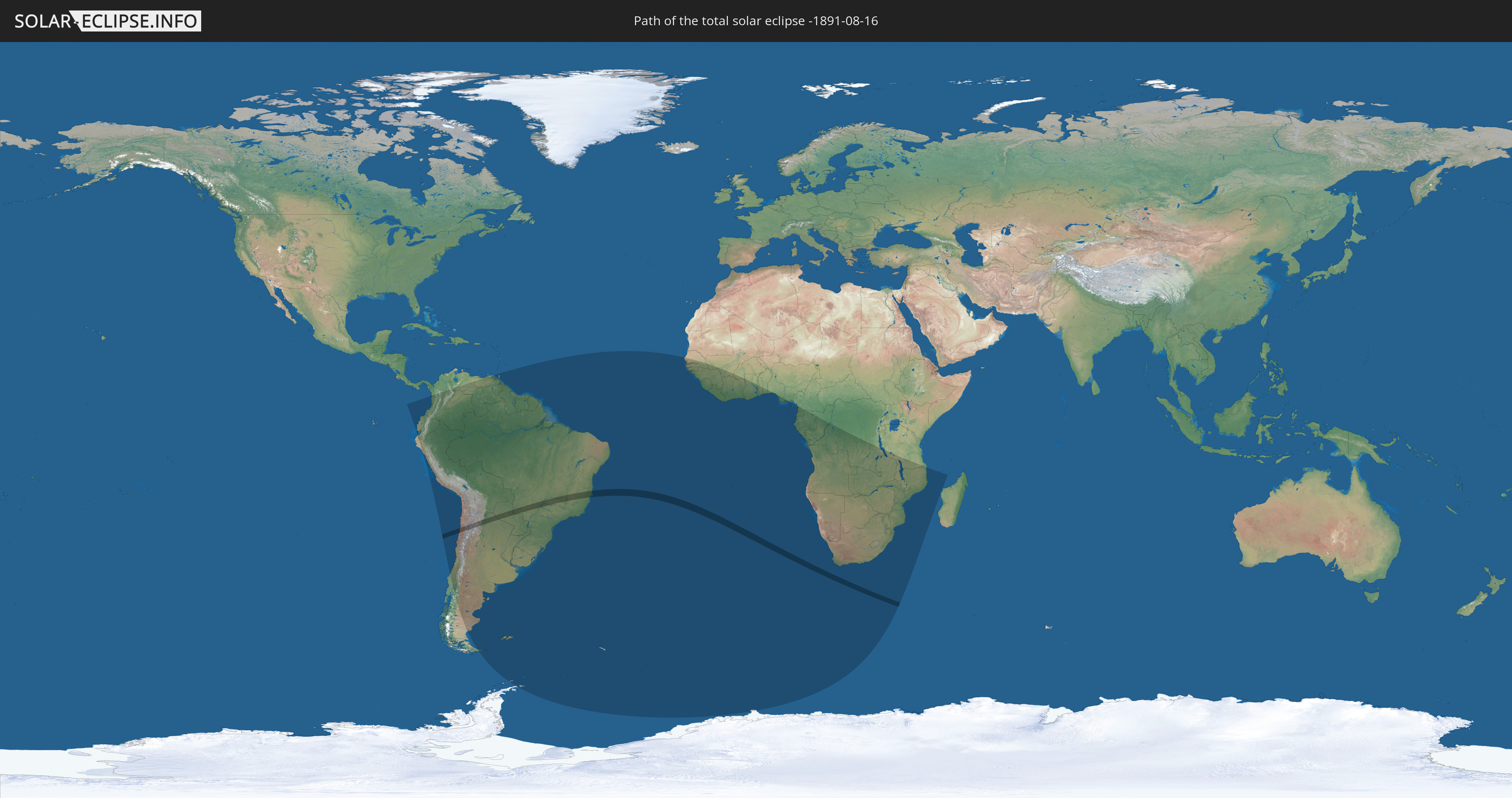
Die Sonnenfinsternis am 16.08.-1891 kann man in 53 Ländern als partielle Sonnenfinsternis beobachten.
Der Finsternispfad verläuft durch 4 Länder. Nur in diesen Ländern ist sie als totale Sonnenfinsternis zu sehen.
In den folgenden Ländern ist die Sonnenfinsternis total zu sehen
 Chile
Chile
 Brasilien
 Argentinien
 Paraguay
In den folgenden Ländern ist die Sonnenfinsternis partiell zu sehen
 Antarktika
 Chile
Chile
 Ecuador
 Kolumbien
 Peru
Peru
 Brasilien
 Argentinien
 Venezuela
 Bolivien
 Paraguay
 Trinidad und Tobago
 Falklandinseln
 Guyana
 Uruguay
 Suriname
 Französisch-Guayana
 Südgeorgien und die Südlichen Sandwichinseln
 Kap Verde
 Senegal
 Gambia
 Guinea-Bissau
 Guinea
 St. Helena
 Sierra Leone
 Mali
Mali
 Liberia
 Elfenbeinküste
 Burkina Faso
 Ghana
Ghana
 Togo
Togo
 Benin
Benin
 Nigeria
 Bouvetinsel
 Äquatorialguinea
 São Tomé und Príncipe
 Kamerun
 Gabun
Gabun
 Republik Kongo
 Angola
 Namibia
 Demokratische Republik Kongo
 Südafrika
 Botswana
 Sambia
 Simbabwe
 Lesotho
 Tansania
 Mosambik
 Swasiland
 Malawi
 Französische Süd- und Antarktisgebiete
 Komoren
 Mayotte
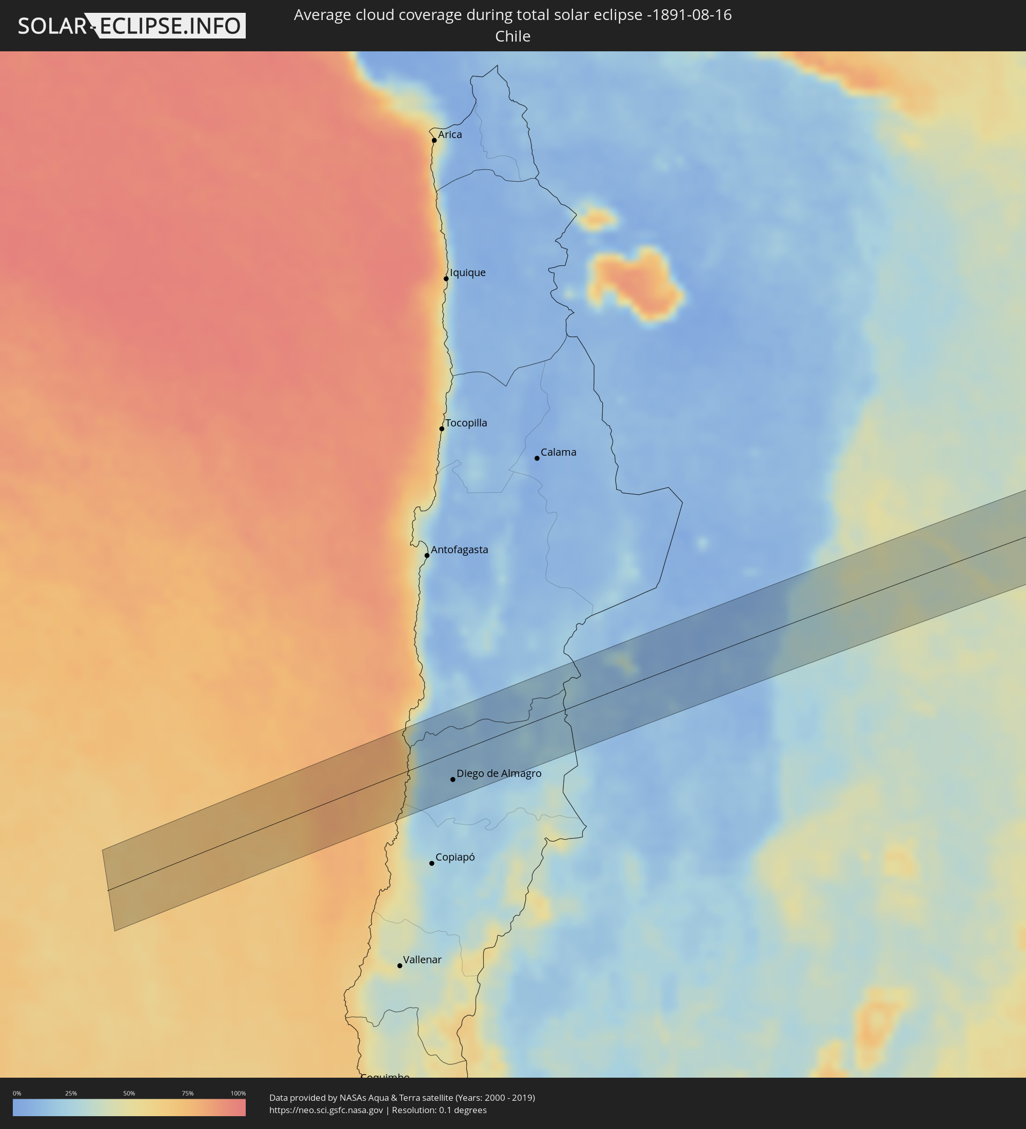
Wie wird das Wetter während der totalen Sonnenfinsternis am 16.08.-1891?
Wo ist der beste Ort, um die totale Sonnenfinsternis vom 16.08.-1891 zu beobachten?
Die folgenden Karten zeigen die durchschnittliche Bewölkung für den Tag, an dem die totale Sonnenfinsternis
stattfindet. Mit Hilfe der Karten lässt sich der Ort entlang des Finsternispfades eingrenzen,
der die besten Aussichen auf einen klaren wolkenfreien Himmel bietet.
Trotzdem muss man immer lokale Gegenenheiten beachten und sollte sich genau über das Wetter an seinem
gewählten Beobachtungsort informieren.
Die Daten stammen von den beiden NASA-Satelliten
AQUA und TERRA
und wurden über einen Zeitraum von 19 Jahren (2000 - 2019) gemittelt.


Detaillierte Länderkarten
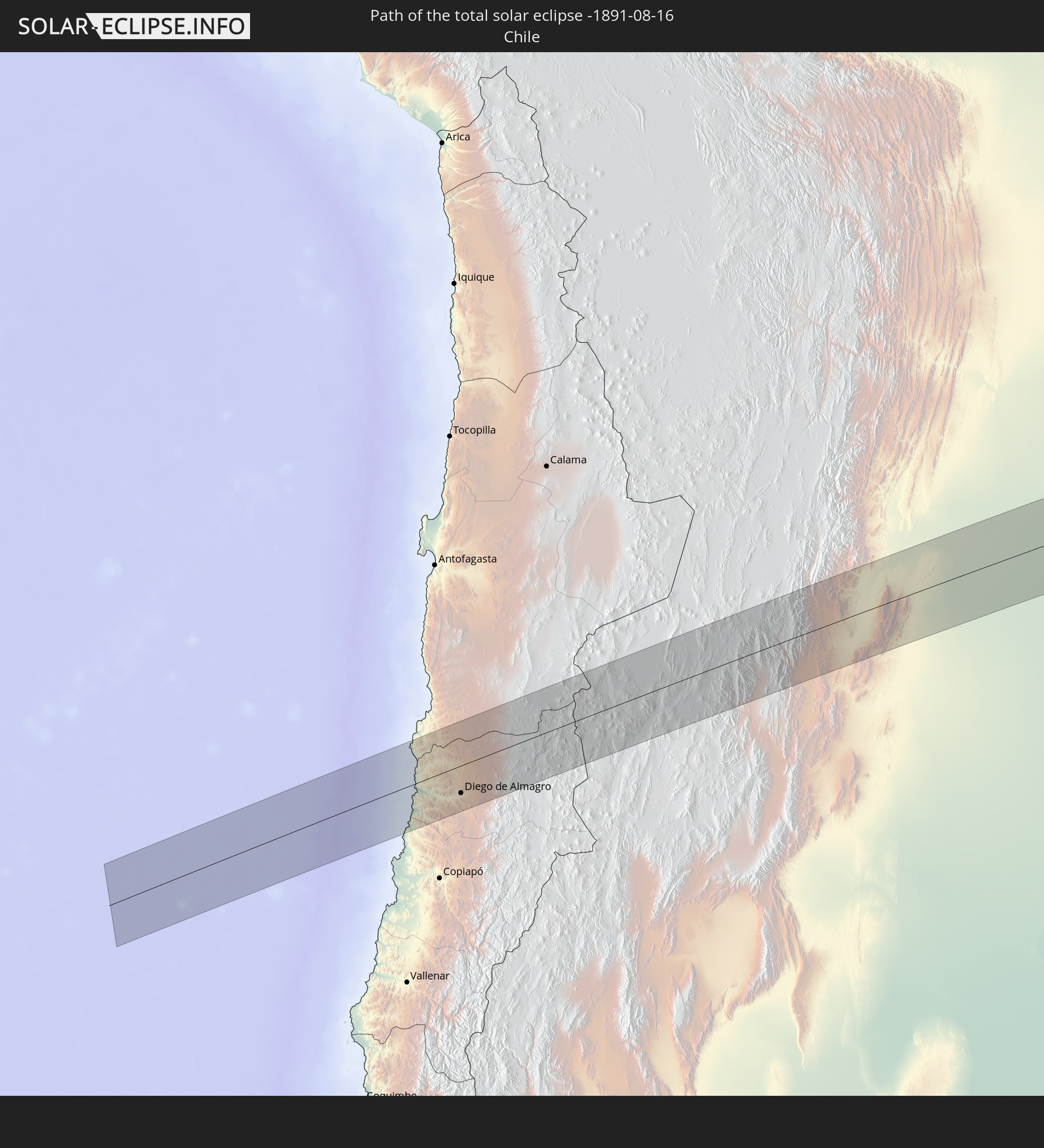
 Chile
Chile
 Brasilien
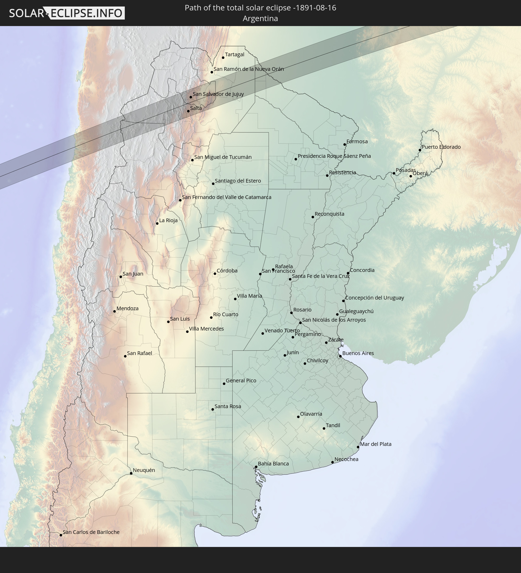
 Argentinien
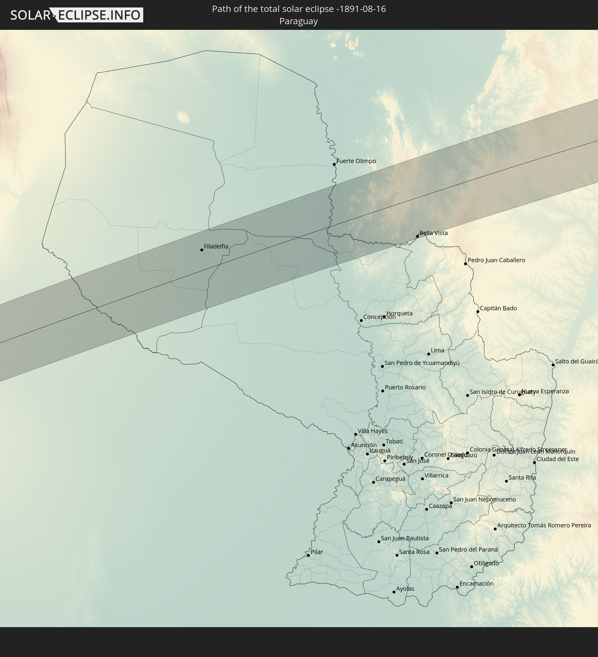
 Paraguay
Orte im Finsternispfad
Die nachfolgene Tabelle zeigt Städte und Orte mit mehr als 5.000 Einwohnern, die sich im Finsternispfad befinden. Städte mit mehr als 100.000 Einwohnern sind dick gekennzeichnet. Mit einem Klick auf den Ort öffnet sich eine Detailkarte die die Lage des jeweiligen Ortes zusammen mit dem Verlauf der zentralen Finsternis präsentiert.
| Ort | Typ | Dauer der Verfinsterung | Ortszeit bei maximaler Verfinsterung | Entfernung zur Zentrallinie | Ø Bewölkung |
|
Diego de Almagro, Atacama
|
total | - | 07:01:51 UTC-04:42 | 34 km | 18% |
|
Salta, Salta Province
|
total | - | 07:29:11 UTC-04:16 | 37 km | 29% |
|
San Salvador de Jujuy, Jujuy Province
|
total | - | 07:28:44 UTC-04:16 | 21 km | 29% |
|
Palpalá, Jujuy Province
|
total | - | 07:28:51 UTC-04:16 | 11 km | 27% |
|
San Pedro, Jujuy Province
|
total | - | 07:29:04 UTC-04:16 | 2 km | 34% |
|
Ingenio La Esperanza, Jujuy Province
|
total | - | 07:29:05 UTC-04:16 | 1 km | 37% |
|
Fraile Pintado, Jujuy Province
|
total | - | 07:28:52 UTC-04:16 | 30 km | 39% |
|
Libertador General San Martín, Jujuy Province
|
total | - | 07:28:45 UTC-04:16 | 43 km | 42% |
|
Calilegua, Jujuy Province
|
total | - | 07:28:44 UTC-04:16 | 46 km | 42% |
|
Caimancito, Jujuy Province
|
total | - | 07:28:50 UTC-04:16 | 43 km | 43% |
|
Yuto, Jujuy Province
|
total | - | 07:28:51 UTC-04:16 | 49 km | 40% |
|
Palma Sola, Jujuy Province
|
total | - | 07:29:15 UTC-04:16 | 10 km | 37% |
|
Apolinario Saravia, Salta Province
|
total | - | 07:29:54 UTC-04:16 | 50 km | 42% |
|
Filadelfia, Boquerón
|
total | - | 07:57:38 UTC-03:50 | 32 km | 53% |
|
Colonia Menno, Boquerón
|
total | - | 07:57:51 UTC-03:50 | 22 km | 53% |
|
Bela Vista, Mato Grosso do Sul
|
total | - | 08:01:08 UTC-03:50 | 60 km | 42% |
|
Bella Vista, Amambay
|
total | - | 08:01:09 UTC-03:50 | 63 km | 42% |
|
Bonito, Mato Grosso do Sul
|
total | - | 08:12:33 UTC-03:38 | 43 km | 40% |
|
Jardim, Mato Grosso do Sul
|
total | - | 08:13:15 UTC-03:38 | 6 km | 40% |
|
Maracaju, Mato Grosso do Sul
|
total | - | 08:14:31 UTC-03:38 | 51 km | 43% |
|
Sidrolândia, Mato Grosso do Sul
|
total | - | 08:14:13 UTC-03:38 | 15 km | 38% |
|
Campo Grande, Mato Grosso do Sul
|
total | - | 08:14:12 UTC-03:38 | 57 km | 30% |
|
Campo Verde, Mato Grosso do Sul
|
total | - | 08:14:55 UTC-03:38 | 42 km | 30% |
|
Três Lagoas, Mato Grosso do Sul
|
total | - | 08:18:26 UTC-03:38 | 69 km | 28% |
|
Ilha Solteira, São Paulo
|
total | - | 08:50:40 UTC-03:06 | 41 km | 22% |
|
Paranaíba, Mato Grosso do Sul
|
total | - | 08:18:17 UTC-03:38 | 35 km | 21% |
|
Aparecida do Taboado, Mato Grosso do Sul
|
total | - | 08:18:45 UTC-03:38 | 11 km | 20% |
|
Santa Fé do Sul, São Paulo
|
total | - | 08:51:06 UTC-03:06 | 29 km | 20% |
|
Jales, São Paulo
|
total | - | 08:51:43 UTC-03:06 | 46 km | 20% |
|
Fernandópolis, São Paulo
|
total | - | 08:52:11 UTC-03:06 | 56 km | 21% |
|
Iturama, Minas Gerais
|
total | - | 08:51:49 UTC-03:06 | 2 km | 15% |
|
Campina Verde, Minas Gerais
|
total | - | 08:52:46 UTC-03:06 | 3 km | 17% |
|
Ituiutaba, Minas Gerais
|
total | - | 08:52:22 UTC-03:06 | 63 km | 16% |
|
Frutal, Minas Gerais
|
total | - | 08:54:01 UTC-03:06 | 64 km | 18% |
|
Prata, Minas Gerais
|
total | - | 08:53:29 UTC-03:06 | 12 km | 18% |
|
Conceição das Alagoas, Minas Gerais
|
total | - | 08:54:50 UTC-03:06 | 67 km | 17% |
|
Uberlândia, Minas Gerais
|
total | - | 08:54:14 UTC-03:06 | 37 km | 18% |
|
Araguari, Minas Gerais
|
total | - | 08:54:11 UTC-03:06 | 64 km | 14% |
|
Uberaba, Minas Gerais
|
total | - | 08:55:27 UTC-03:06 | 61 km | 21% |
|
Monte Carmelo, Minas Gerais
|
total | - | 08:55:23 UTC-03:06 | 38 km | 20% |
|
Coromandel, Minas Gerais
|
total | - | 08:55:43 UTC-03:06 | 58 km | 21% |
|
Patrocínio, Minas Gerais
|
total | - | 08:56:26 UTC-03:06 | 2 km | 20% |
|
Araxá, Minas Gerais
|
total | - | 08:57:02 UTC-03:06 | 69 km | 25% |
|
Ibiá, Minas Gerais
|
total | - | 08:57:39 UTC-03:06 | 67 km | 25% |
|
Patos de Minas, Minas Gerais
|
total | - | 08:56:59 UTC-03:06 | 30 km | 20% |
|
Presidente Olegário, Minas Gerais
|
total | - | 08:57:02 UTC-03:06 | 45 km | 22% |
|
Carmo do Paranaíba, Minas Gerais
|
total | - | 08:57:40 UTC-03:06 | 20 km | 21% |
|
São Gotardo, Minas Gerais
|
total | - | 08:58:23 UTC-03:06 | 60 km | 30% |
|
Abaeté, Minas Gerais
|
total | - | 08:59:22 UTC-03:06 | 58 km | 28% |
|
Corinto, Minas Gerais
|
total | - | 09:00:37 UTC-03:06 | 5 km | 29% |
|
Curvelo, Minas Gerais
|
total | - | 09:00:58 UTC-03:06 | 37 km | 34% |
|
Diamantina, Minas Gerais
|
total | - | 09:02:10 UTC-03:06 | 1 km | 51% |
|
Guanhães, Minas Gerais
|
total | - | 09:03:55 UTC-03:06 | 70 km | 67% |
|
Itamarandiba, Minas Gerais
|
total | - | 09:03:22 UTC-03:06 | 29 km | 64% |
|
Capelinha, Minas Gerais
|
total | - | 09:03:56 UTC-03:06 | 41 km | 68% |
|
Itambacuri, Minas Gerais
|
total | - | 09:05:55 UTC-03:06 | 12 km | 74% |
|
Teófilo Otoni, Minas Gerais
|
total | - | 09:06:10 UTC-03:06 | 4 km | 74% |
|
Ecoporanga, Espírito Santo
|
total | - | 09:08:00 UTC-03:06 | 64 km | 77% |
|
Carlos Chagas, Minas Gerais
|
total | - | 09:07:37 UTC-03:06 | 9 km | 76% |
|
Nanuque, Minas Gerais
|
total | - | 09:08:38 UTC-03:06 | 12 km | 77% |
|
Itanhém, Bahia
|
total | - | 09:40:38 UTC-02:34 | 61 km | 76% |
|
Medeiros Neto, Bahia
|
total | - | 09:41:02 UTC-02:34 | 37 km | 76% |
|
Mucuri, Bahia
|
total | - | 09:43:04 UTC-02:34 | 52 km | 63% |
|
Itamaraju, Bahia
|
total | - | 09:42:19 UTC-02:34 | 64 km | 76% |
|
Nova Viçosa, Bahia
|
total | - | 09:43:19 UTC-02:34 | 33 km | 57% |
|
Prado, Bahia
|
total | - | 09:43:15 UTC-02:34 | 26 km | 54% |