Totale Sonnenfinsternis vom 21.03.-1967
| Wochentag: | Samstag |
| Maximale Dauer der Verfinsterung: | 04m38s |
| Maximale Breite des Finsternispfades: | 218 km |
| Saroszyklus: | -2 |
| Bedeckungsgrad: | 100% |
| Magnitude: | 1.0537 |
| Gamma: | 0.5876 |
Wo kann man die Sonnenfinsternis vom 21.03.-1967 sehen?
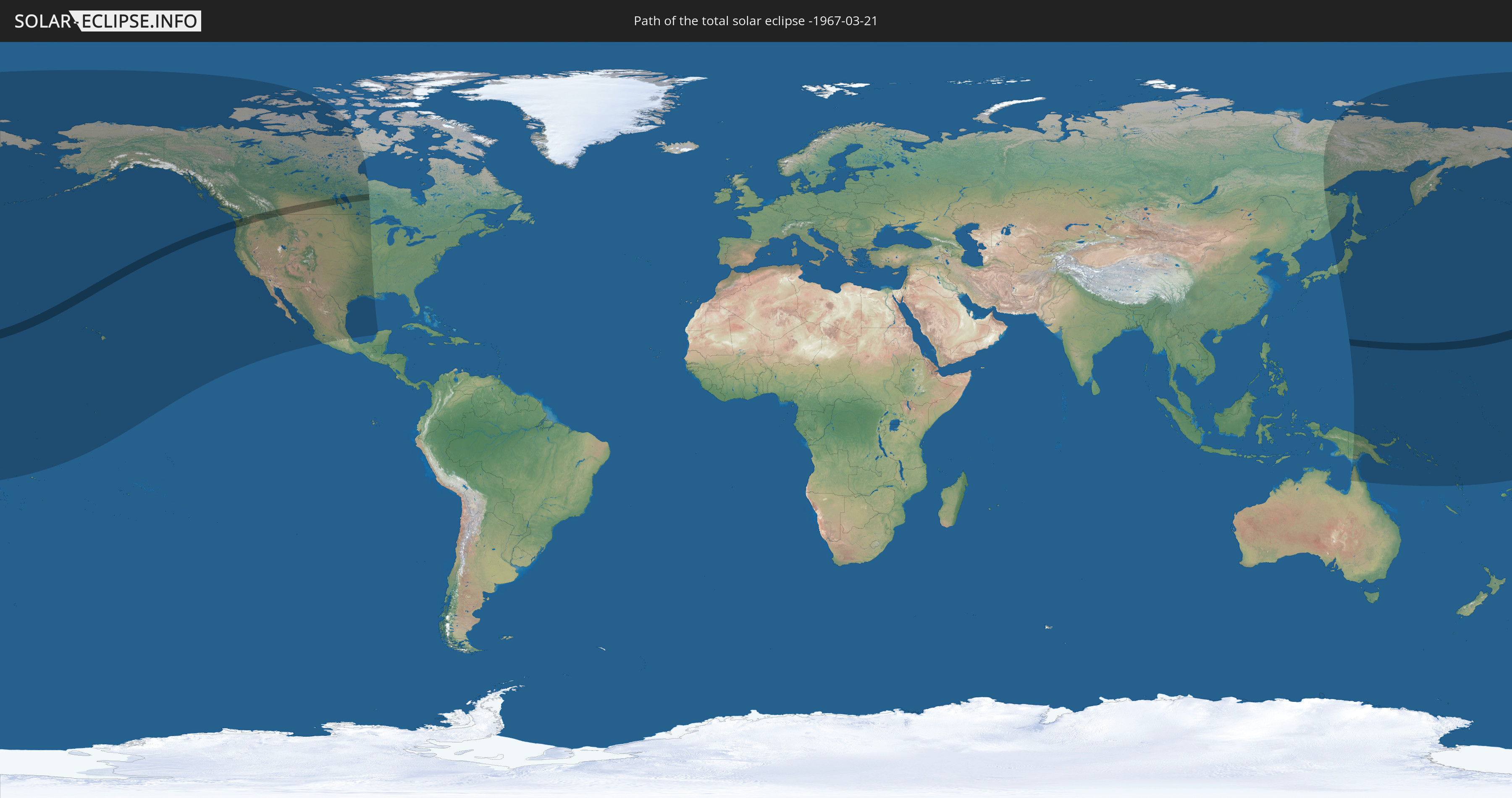
Die Sonnenfinsternis am 21.03.-1967 kann man in 22 Ländern als partielle Sonnenfinsternis beobachten.
Der Finsternispfad verläuft durch 3 Länder. Nur in diesen Ländern ist sie als totale Sonnenfinsternis zu sehen.
In den folgenden Ländern ist die Sonnenfinsternis total zu sehen
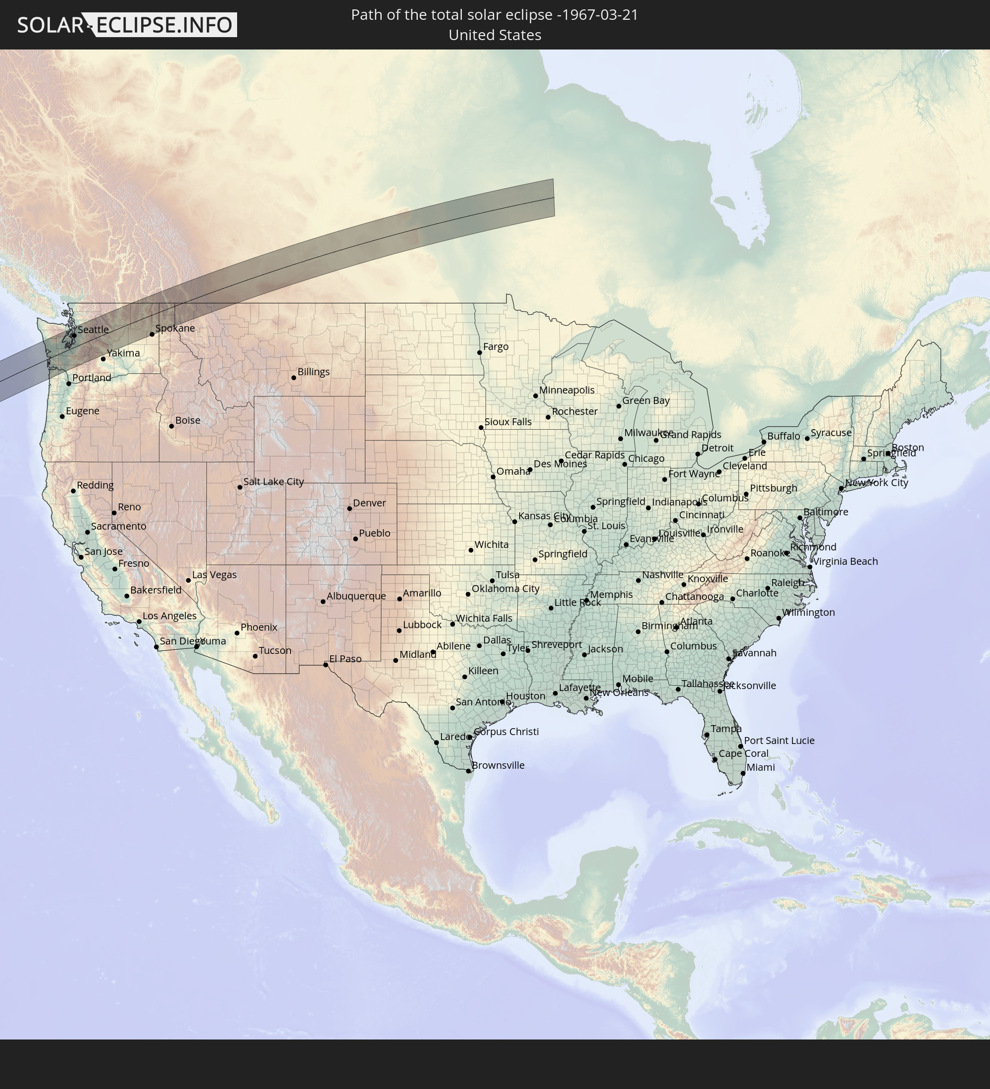 Vereinigte Staaten
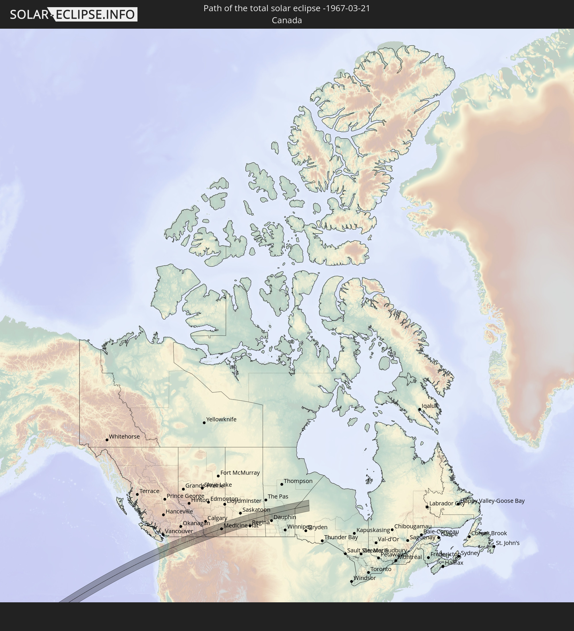 Kanada
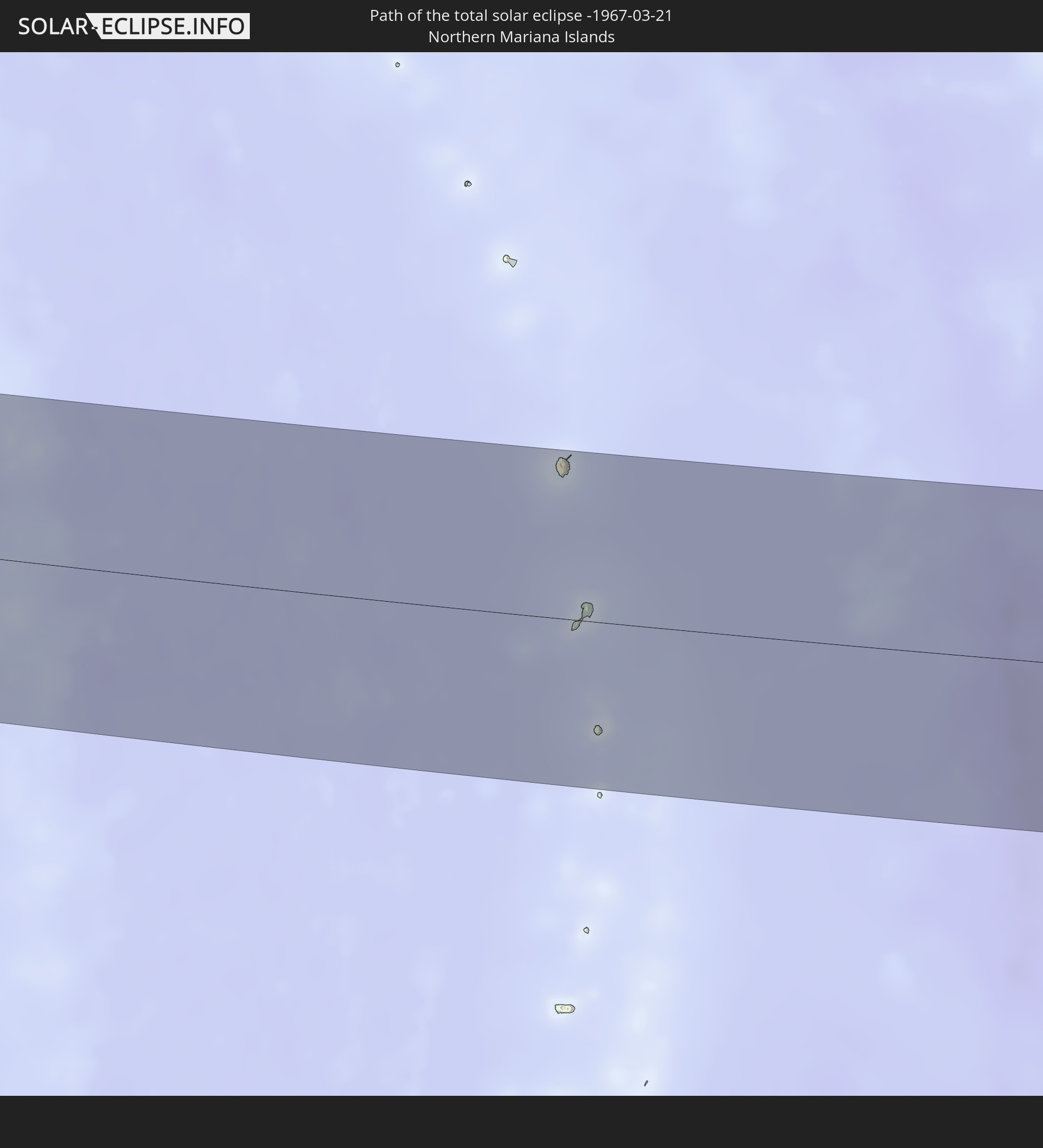 Nördliche Marianen
In den folgenden Ländern ist die Sonnenfinsternis partiell zu sehen
 Fidschi
 Russland
 Vereinigte Staaten
 United States Minor Outlying Islands
 Wallis und Futuna
 Kiribati
 Tokelau
 Amerikanisch-Samoa
 Kanada
 Mexiko
 Grönland
 Australien
 Japan
Japan
 Föderierte Staaten von Mikronesien
 Papua-Neuguinea
 Guam
Guam
 Nördliche Marianen
 Salomonen
 Marshallinseln
 Vanuatu
 Nauru
Nauru
 Tuvalu
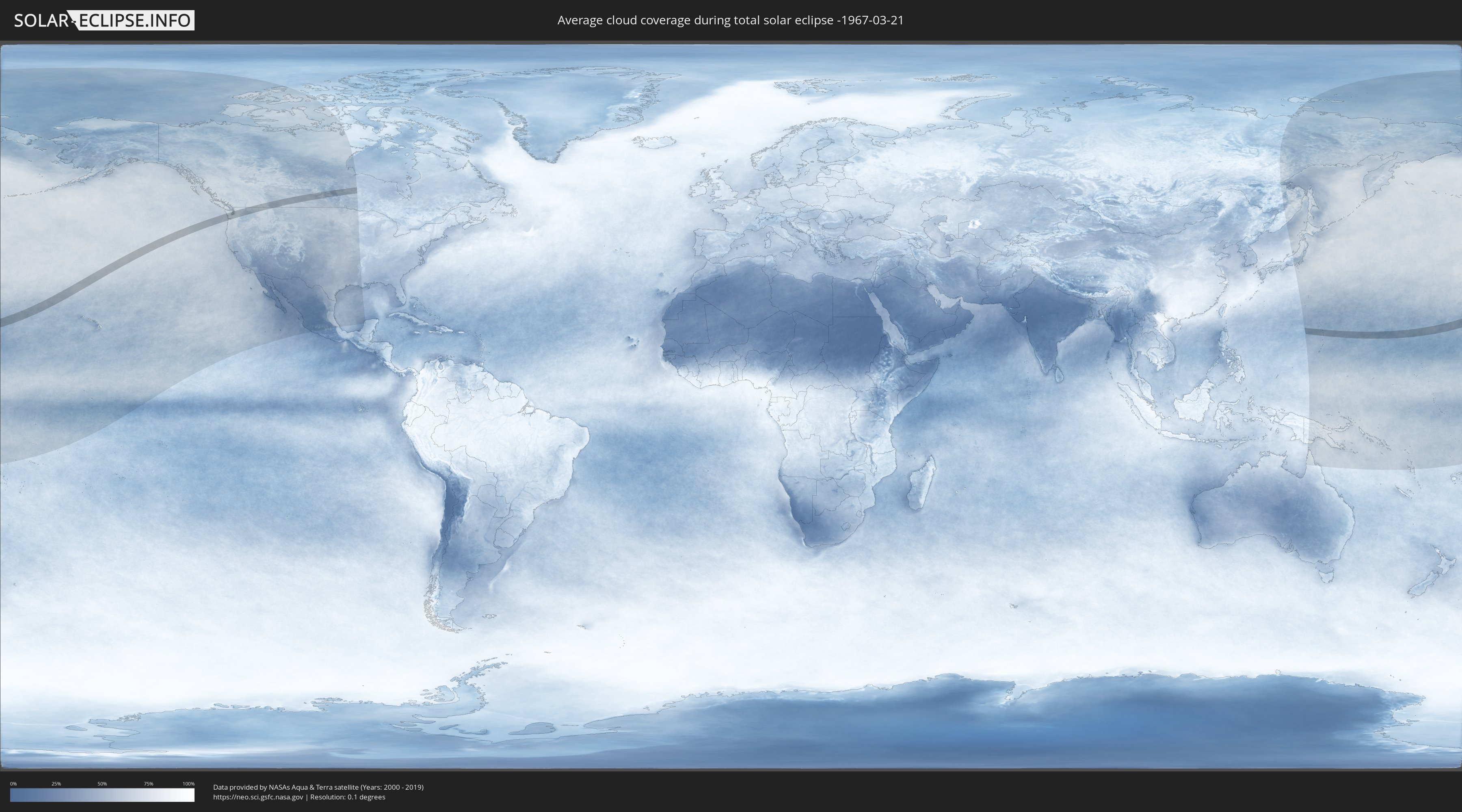
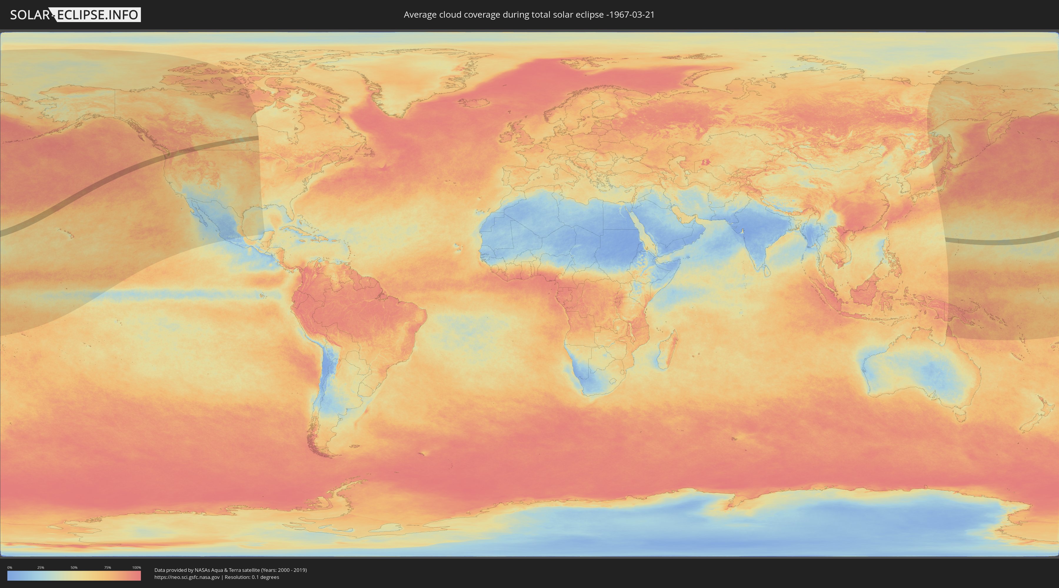
Wie wird das Wetter während der totalen Sonnenfinsternis am 21.03.-1967?
Wo ist der beste Ort, um die totale Sonnenfinsternis vom 21.03.-1967 zu beobachten?
Die folgenden Karten zeigen die durchschnittliche Bewölkung für den Tag, an dem die totale Sonnenfinsternis
stattfindet. Mit Hilfe der Karten lässt sich der Ort entlang des Finsternispfades eingrenzen,
der die besten Aussichen auf einen klaren wolkenfreien Himmel bietet.
Trotzdem muss man immer lokale Gegenenheiten beachten und sollte sich genau über das Wetter an seinem
gewählten Beobachtungsort informieren.
Die Daten stammen von den beiden NASA-Satelliten
AQUA und TERRA
und wurden über einen Zeitraum von 19 Jahren (2000 - 2019) gemittelt.
Detaillierte Länderkarten
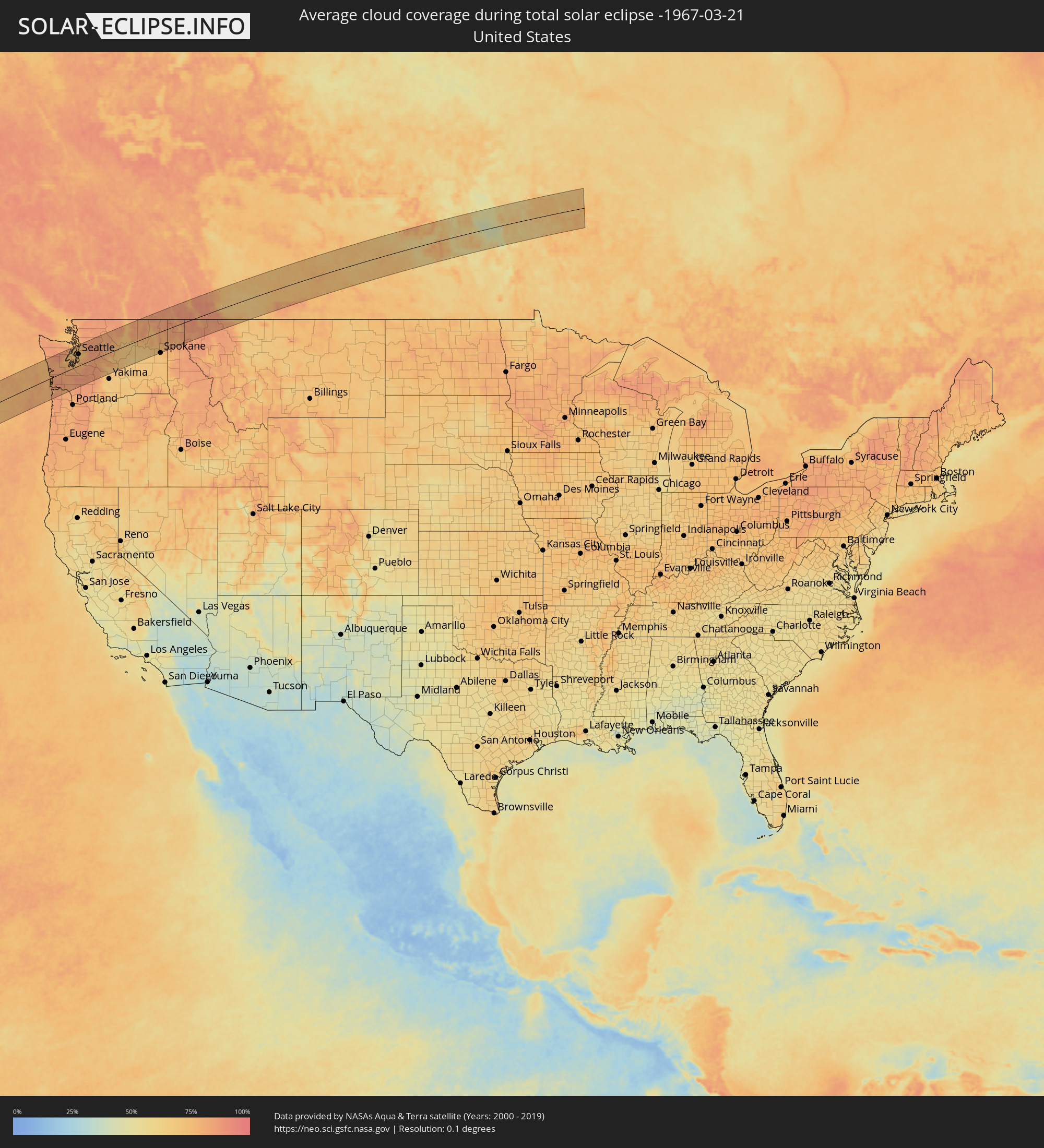 Vereinigte Staaten
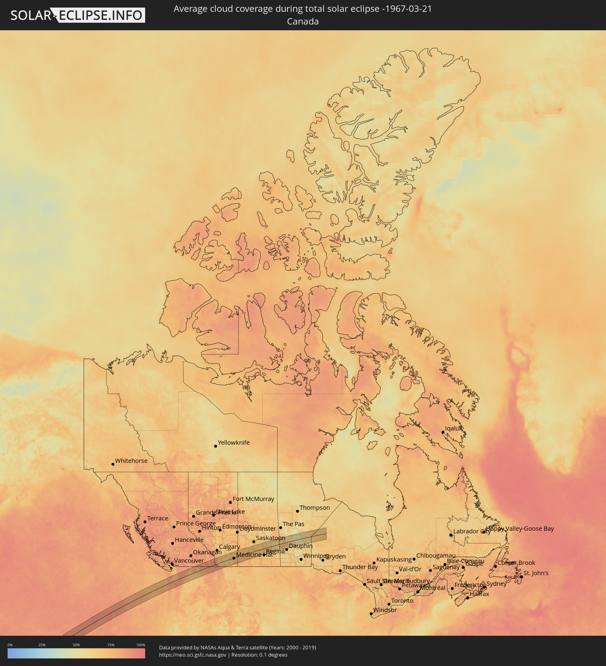 Kanada
 Nördliche Marianen
Orte im Finsternispfad
Die nachfolgene Tabelle zeigt Städte und Orte mit mehr als 5.000 Einwohnern, die sich im Finsternispfad befinden. Städte mit mehr als 100.000 Einwohnern sind dick gekennzeichnet. Mit einem Klick auf den Ort öffnet sich eine Detailkarte die die Lage des jeweiligen Ortes zusammen mit dem Verlauf der zentralen Finsternis präsentiert.
| Ort | Typ | Dauer der Verfinsterung | Ortszeit bei maximaler Verfinsterung | Entfernung zur Zentrallinie | Ø Bewölkung |
|
Seaside, Oregon
|
total | - | 15:36:38 UTC-08:00 | 67 km | 83% |
|
Hoquiam, Washington
|
total | - | 15:36:09 UTC-08:00 | 32 km | 81% |
|
Astoria, Oregon
|
total | - | 15:36:37 UTC-08:00 | 51 km | 78% |
|
Aberdeen, Washington
|
total | - | 15:36:13 UTC-08:00 | 29 km | 84% |
|
Shelton, Washington
|
total | - | 15:36:44 UTC-08:00 | 31 km | 76% |
|
Chehalis, Washington
|
total | - | 15:37:09 UTC-08:00 | 29 km | 81% |
|
Centralia, Washington
|
total | - | 15:37:08 UTC-08:00 | 24 km | 81% |
|
Longview, Washington
|
total | - | 15:37:28 UTC-08:00 | 84 km | 80% |
|
Tumwater, Washington
|
total | - | 15:37:01 UTC-08:00 | 4 km | 80% |
|
Kelso, Washington
|
total | - | 15:37:29 UTC-08:00 | 84 km | 80% |
|
Olympia, Washington
|
total | - | 15:37:00 UTC-08:00 | 7 km | 80% |
|
Bangor Trident Base, Washington
|
total | - | 15:36:47 UTC-08:00 | 71 km | 73% |
|
Silverdale, Washington
|
total | - | 15:36:50 UTC-08:00 | 62 km | 74% |
|
Poulsbo, Washington
|
total | - | 15:36:50 UTC-08:00 | 70 km | 71% |
|
Port Orchard, Washington
|
total | - | 15:36:57 UTC-08:00 | 50 km | 74% |
|
Bremerton, Washington
|
total | - | 15:36:56 UTC-08:00 | 53 km | 73% |
|
DuPont, Washington
|
total | - | 15:37:13 UTC-08:00 | 5 km | 79% |
|
Artondale, Washington
|
total | - | 15:37:06 UTC-08:00 | 25 km | 71% |
|
Parkwood, Washington
|
total | - | 15:36:59 UTC-08:00 | 48 km | 74% |
|
Yelm, Washington
|
total | - | 15:37:19 UTC-08:00 | 12 km | 83% |
|
Steilacoom, Washington
|
total | - | 15:37:12 UTC-08:00 | 11 km | 74% |
|
Wollochet, Washington
|
total | - | 15:37:09 UTC-08:00 | 21 km | 71% |
|
Gig Harbor, Washington
|
total | - | 15:37:07 UTC-08:00 | 27 km | 71% |
|
Fort Lewis, Washington
|
total | - | 15:37:15 UTC-08:00 | 4 km | 79% |
|
Bainbridge Island, Washington
|
total | - | 15:37:00 UTC-08:00 | 55 km | 72% |
|
Fircrest, Washington
|
total | - | 15:37:14 UTC-08:00 | 16 km | 77% |
|
Vashon, Washington
|
total | - | 15:37:10 UTC-08:00 | 35 km | 72% |
|
Tacoma, Washington
|
total | - | 15:37:17 UTC-08:00 | 15 km | 73% |
|
Klahanie, Washington
|
total | - | 15:37:11 UTC-08:00 | 33 km | 74% |
|
Spanaway, Washington
|
total | - | 15:37:23 UTC-08:00 | 1 km | 80% |
|
Midland, Washington
|
total | - | 15:37:22 UTC-08:00 | 5 km | 78% |
|
Elk Plain, Washington
|
total | - | 15:37:26 UTC-08:00 | 7 km | 80% |
|
Waller, Washington
|
total | - | 15:37:23 UTC-08:00 | 7 km | 78% |
|
Frederickson, Washington
|
total | - | 15:37:27 UTC-08:00 | 4 km | 80% |
|
Fife, Washington
|
total | - | 15:37:22 UTC-08:00 | 11 km | 78% |
|
Summit, Washington
|
total | - | 15:37:25 UTC-08:00 | 3 km | 78% |
|
White Center, Washington
|
total | - | 15:37:13 UTC-08:00 | 39 km | 73% |
|
Shoreline, Washington
|
total | - | 15:37:05 UTC-08:00 | 63 km | 72% |
|
Normandy Park, Washington
|
total | - | 15:37:16 UTC-08:00 | 30 km | 75% |
|
Seattle, Washington
|
total | - | 15:37:11 UTC-08:00 | 47 km | 72% |
|
Milton, Washington
|
total | - | 15:37:24 UTC-08:00 | 10 km | 80% |
|
Mountlake Terrace, Washington
|
total | - | 15:37:05 UTC-08:00 | 65 km | 72% |
|
Mukilteo, Washington
|
total | - | 15:37:00 UTC-08:00 | 81 km | 73% |
|
Riverton, Washington
|
total | - | 15:37:17 UTC-08:00 | 34 km | 74% |
|
Graham, Washington
|
total | - | 15:37:32 UTC-08:00 | 10 km | 79% |
|
Edgewood, Washington
|
total | - | 15:37:25 UTC-08:00 | 10 km | 76% |
|
SeaTac, Washington
|
total | - | 15:37:18 UTC-08:00 | 30 km | 75% |
|
Lakeland South, Washington
|
total | - | 15:37:25 UTC-08:00 | 13 km | 76% |
|
Alderwood Manor, Washington
|
total | - | 15:37:06 UTC-08:00 | 68 km | 72% |
|
Lake Forest Park, Washington
|
total | - | 15:37:08 UTC-08:00 | 61 km | 72% |
|
Lakeland North, Washington
|
total | - | 15:37:23 UTC-08:00 | 18 km | 76% |
|
Brier, Washington
|
total | - | 15:37:07 UTC-08:00 | 64 km | 72% |
|
South Hill, Washington
|
total | - | 15:37:30 UTC-08:00 | 2 km | 79% |
|
Tukwila, Washington
|
total | - | 15:37:19 UTC-08:00 | 32 km | 74% |
|
Pacific, Washington
|
total | - | 15:37:27 UTC-08:00 | 10 km | 76% |
|
Kenmore, Washington
|
total | - | 15:37:10 UTC-08:00 | 60 km | 72% |
|
Bryn Mawr-Skyway, Washington
|
total | - | 15:37:19 UTC-08:00 | 33 km | 76% |
|
Sumner, Washington
|
total | - | 15:37:29 UTC-08:00 | 4 km | 79% |
|
Martha Lake, Washington
|
total | - | 15:37:07 UTC-08:00 | 70 km | 75% |
|
Kent, Washington
|
total | - | 15:37:24 UTC-08:00 | 22 km | 76% |
|
Inglewood-Finn Hill, Washington
|
total | - | 15:37:12 UTC-08:00 | 56 km | 73% |
|
Mercer Island, Washington
|
total | - | 15:37:18 UTC-08:00 | 41 km | 75% |
|
Mill Creek, Washington
|
total | - | 15:37:08 UTC-08:00 | 70 km | 75% |
|
Orting, Washington
|
total | - | 15:37:35 UTC-08:00 | 8 km | 80% |
|
Everett, Washington
|
total | - | 15:37:04 UTC-08:00 | 82 km | 76% |
|
Bonney Lake, Washington
|
total | - | 15:37:33 UTC-08:00 | 1 km | 79% |
|
Lea Hill, Washington
|
total | - | 15:37:28 UTC-08:00 | 14 km | 78% |
|
Kingsgate, Washington
|
total | - | 15:37:14 UTC-08:00 | 55 km | 73% |
|
North Creek, Washington
|
total | - | 15:37:11 UTC-08:00 | 65 km | 72% |
|
Woodinville, Washington
|
total | - | 15:37:14 UTC-08:00 | 57 km | 72% |
|
Fairwood, Washington
|
total | - | 15:37:25 UTC-08:00 | 26 km | 76% |
|
Newcastle, Washington
|
total | - | 15:37:22 UTC-08:00 | 35 km | 76% |
|
Silver Firs, Washington
|
total | - | 15:37:10 UTC-08:00 | 69 km | 75% |
|
Prairie Ridge, Washington
|
total | - | 15:37:36 UTC-08:00 | 6 km | 82% |
|
Covington, Washington
|
total | - | 15:37:30 UTC-08:00 | 16 km | 78% |
|
Redmond, Washington
|
total | - | 15:37:19 UTC-08:00 | 48 km | 75% |
|
Maltby, Washington
|
total | - | 15:37:15 UTC-08:00 | 61 km | 75% |
|
East Renton Highlands, Washington
|
total | - | 15:37:26 UTC-08:00 | 28 km | 78% |
|
Lake Morton-Berrydale, Washington
|
total | - | 15:37:32 UTC-08:00 | 13 km | 78% |
|
West Lake Stevens, Washington
|
total | - | 15:37:09 UTC-08:00 | 80 km | 79% |
|
Snohomish, Washington
|
total | - | 15:37:12 UTC-08:00 | 72 km | 77% |
|
Cottage Lake, Washington
|
total | - | 15:37:19 UTC-08:00 | 54 km | 75% |
|
Maple Valley, Washington
|
total | - | 15:37:33 UTC-08:00 | 17 km | 81% |
|
Issaquah, Washington
|
total | - | 15:37:29 UTC-08:00 | 31 km | 80% |
|
Union Hill-Novelty Hill, Washington
|
total | - | 15:37:24 UTC-08:00 | 46 km | 76% |
|
Enumclaw, Washington
|
total | - | 15:37:42 UTC-08:00 | 4 km | 81% |
|
Duvall, Washington
|
total | - | 15:37:24 UTC-08:00 | 51 km | 76% |
|
Hobart, Washington
|
total | - | 15:37:36 UTC-08:00 | 18 km | 81% |
|
Monroe, Washington
|
total | - | 15:37:20 UTC-08:00 | 62 km | 78% |
|
Snoqualmie, Washington
|
total | - | 15:37:39 UTC-08:00 | 24 km | 82% |
|
Ellensburg, Washington
|
total | - | 15:39:03 UTC-08:00 | 68 km | 69% |
|
Wenatchee, Washington
|
total | - | 15:38:59 UTC-08:00 | 31 km | 73% |
|
East Wenatchee, Washington
|
total | - | 15:39:00 UTC-08:00 | 32 km | 73% |
|
East Wenatchee Bench, Washington
|
total | - | 15:39:00 UTC-08:00 | 32 km | 73% |
|
Quincy, Washington
|
total | - | 15:39:28 UTC-08:00 | 64 km | 70% |
|
Ephrata, Washington
|
total | - | 15:39:39 UTC-08:00 | 64 km | 68% |
|
Trail, British Columbia
|
total | - | 15:39:51 UTC-08:00 | 68 km | 85% |
|
Airway Heights, Washington
|
total | - | 15:40:56 UTC-08:00 | 85 km | 70% |
|
Fairwood, Washington
|
total | - | 15:40:59 UTC-08:00 | 77 km | 74% |
|
Mead, Washington
|
total | - | 15:41:02 UTC-08:00 | 79 km | 74% |
|
Sandpoint, Idaho
|
total | - | 15:41:15 UTC-08:00 | 48 km | 80% |
|
Kimberley, British Columbia
|
total | - | 16:06:45 UTC-07:33 | 82 km | 84% |
|
Cranbrook, British Columbia
|
total | - | 16:07:02 UTC-07:33 | 59 km | 82% |
|
Fernie, British Columbia
|
total | - | 16:07:29 UTC-07:33 | 41 km | 89% |
|
Lethbridge, Alberta
|
total | - | 16:08:43 UTC-07:33 | 6 km | 67% |
|
Coaldale, Alberta
|
total | - | 16:08:49 UTC-07:33 | 3 km | 65% |
|
Taber, Alberta
|
total | - | 16:09:02 UTC-07:33 | 1 km | 65% |
|
Brooks, Alberta
|
total | - | 16:08:32 UTC-07:33 | 77 km | 72% |
|
Medicine Hat, Alberta
|
total | - | 16:09:39 UTC-07:33 | 9 km | 72% |
|
Swift Current, Saskatchewan
|
total | - | 16:46:08 UTC-06:58 | 46 km | 75% |
|
Moose Jaw, Saskatchewan
|
total | - | 16:47:02 UTC-06:58 | 81 km | 72% |
|
Yorkton, Saskatchewan
|
total | - | 16:47:26 UTC-06:58 | 52 km | 69% |