Totale Sonnenfinsternis vom 24.07.-1973
| Wochentag: | Donnerstag |
| Maximale Dauer der Verfinsterung: | 05m38s |
| Maximale Breite des Finsternispfades: | 201 km |
| Saroszyklus: | 14 |
| Bedeckungsgrad: | 100% |
| Magnitude: | 1.0601 |
| Gamma: | -0.1865 |
Wo kann man die Sonnenfinsternis vom 24.07.-1973 sehen?

Die Sonnenfinsternis am 24.07.-1973 kann man in 101 Ländern als partielle Sonnenfinsternis beobachten.
Der Finsternispfad verläuft durch 26 Länder. Nur in diesen Ländern ist sie als totale Sonnenfinsternis zu sehen.
In den folgenden Ländern ist die Sonnenfinsternis total zu sehen
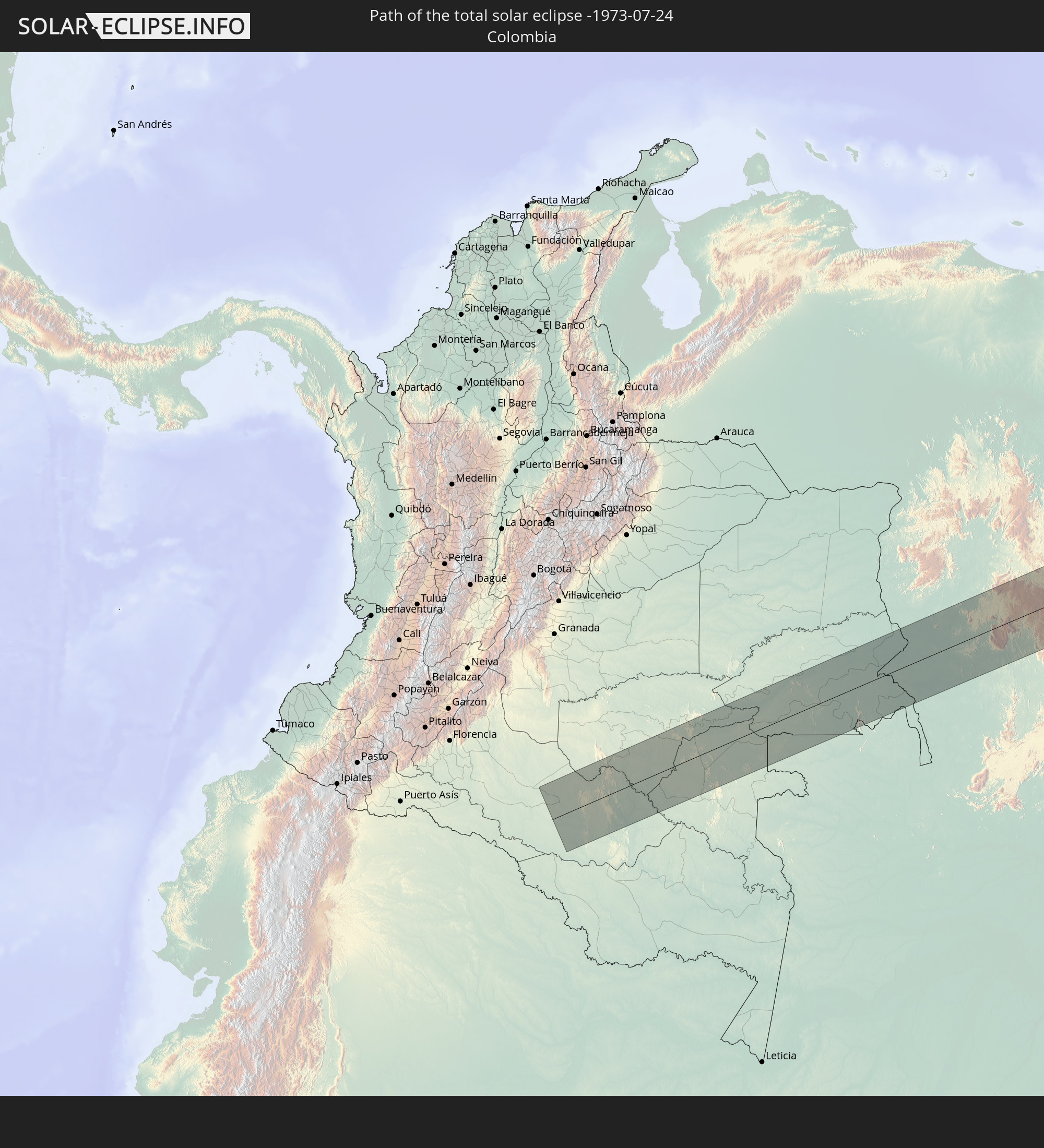 Kolumbien
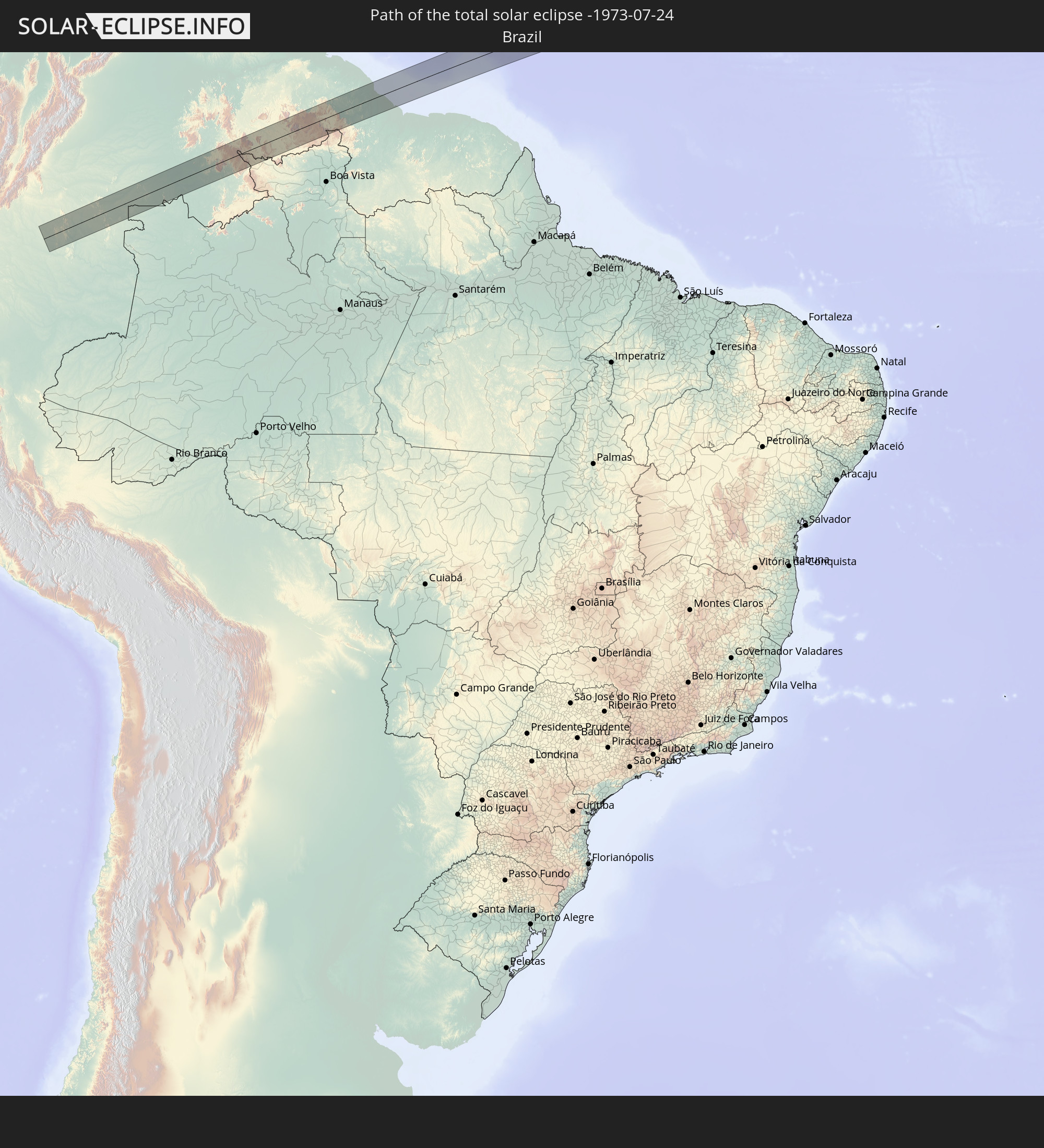 Brasilien
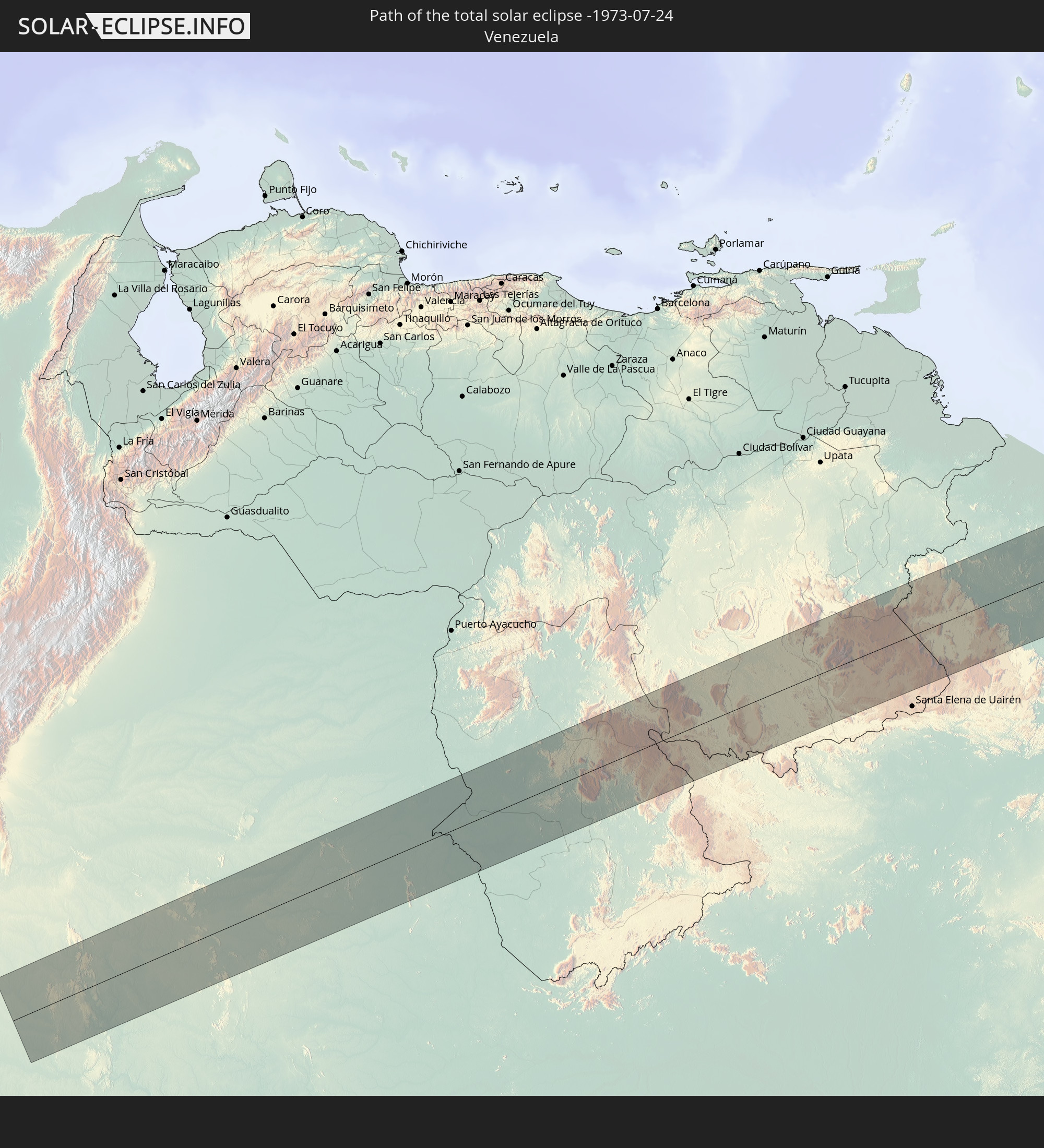 Venezuela
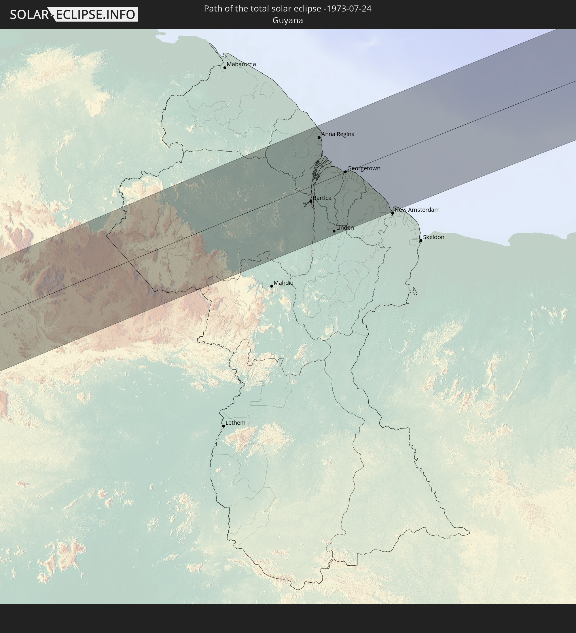 Guyana
 Kap Verde
 Senegal
 Gambia
 Guinea-Bissau
 Guinea
 Mali
Mali
 Elfenbeinküste
 Burkina Faso
 Ghana
Ghana
 Togo
Togo
 Benin
Benin
 Nigeria
 Äquatorialguinea
 Kamerun
 Gabun
Gabun
 Republik Kongo
 Angola
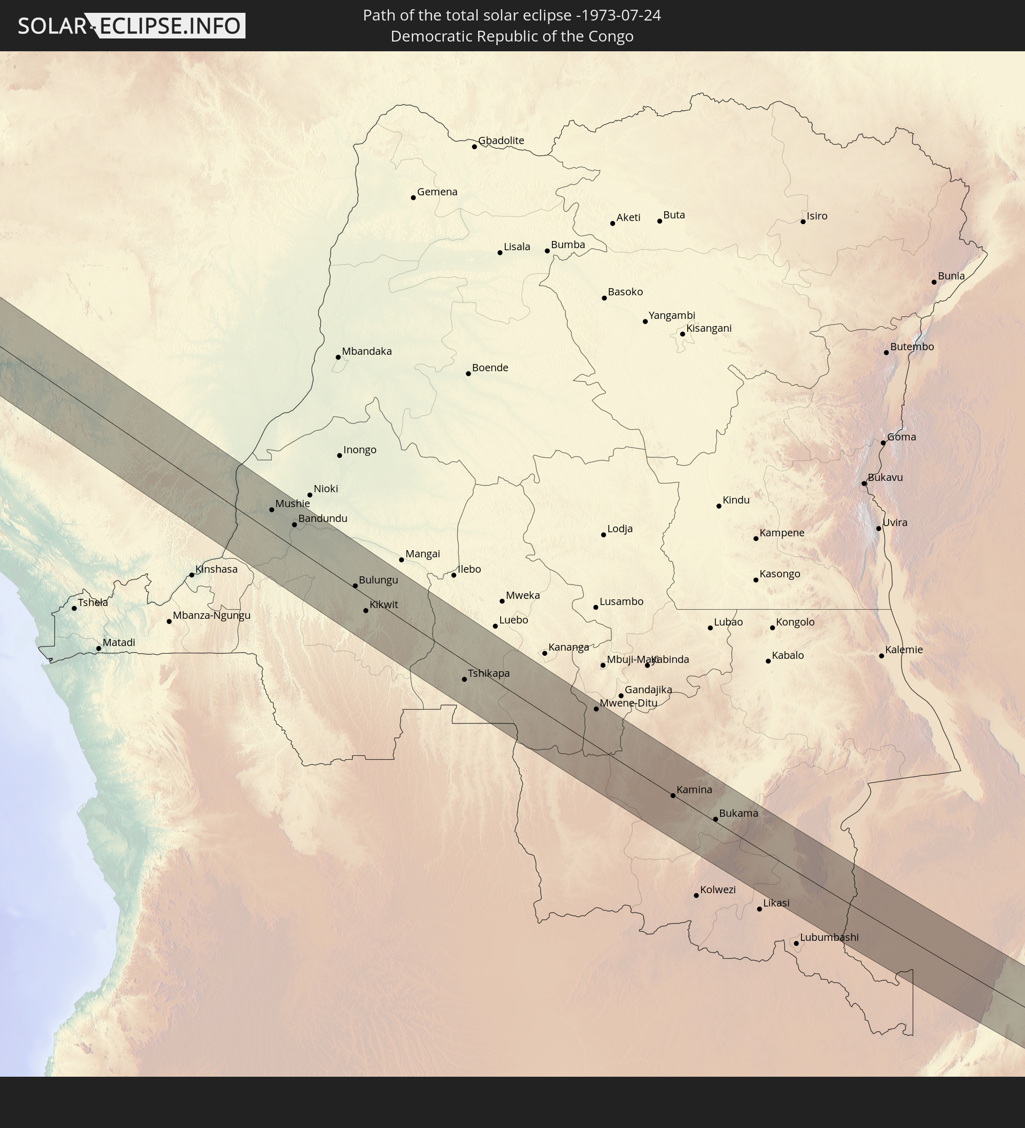 Demokratische Republik Kongo
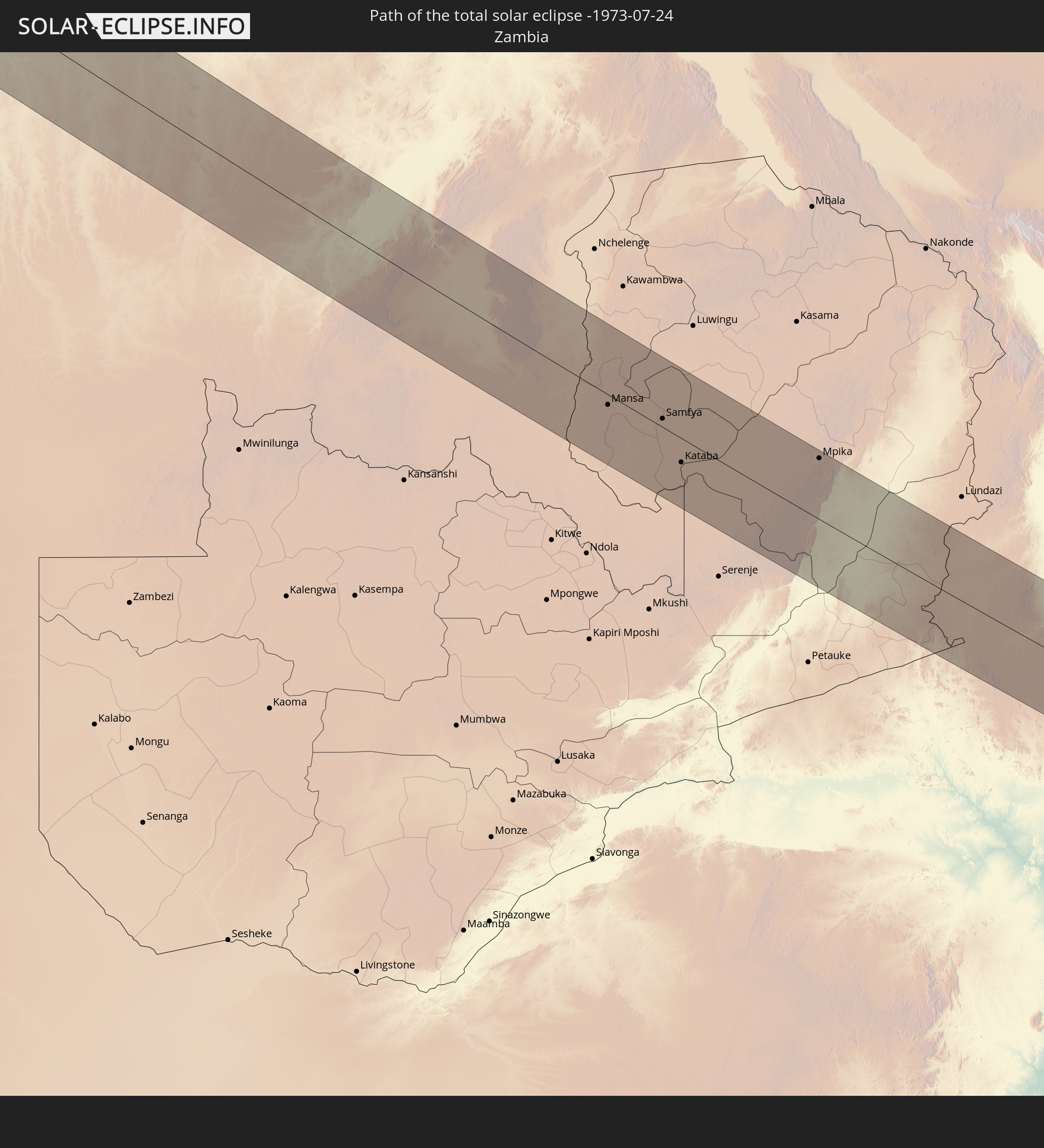 Sambia
 Mosambik
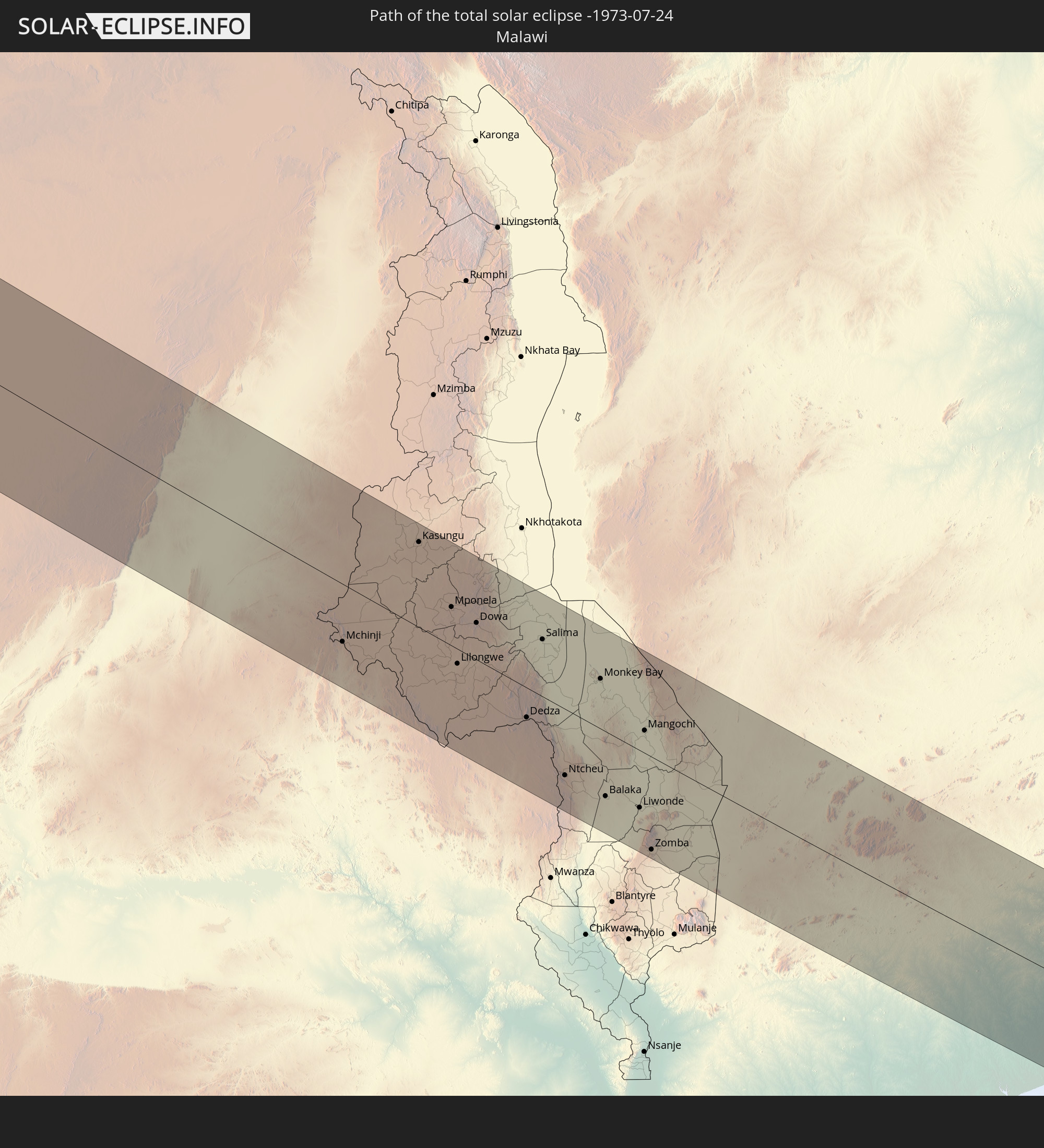 Malawi
 Madagaskar
In den folgenden Ländern ist die Sonnenfinsternis partiell zu sehen
 Vereinigte Staaten
 United States Minor Outlying Islands
 Kuba
Kuba
 Panama
 Kolumbien
 Kaimaninseln
 Peru
Peru
 Bahamas
 Jamaika
 Haiti
Haiti
 Brasilien
 Argentinien
 Venezuela
 Turks- und Caicosinseln
 Dominikanische Republik
 Aruba
Aruba
 Bolivien
 Puerto Rico
 Amerikanische Jungferninseln
 Bermuda
 Britische Jungferninseln
 Anguilla
 Saint-Martin
 Saint-Barthélemy
 St. Kitts und Nevis
 Paraguay
 Antigua und Barbuda
 Montserrat
 Trinidad und Tobago
 Guadeloupe
 Grenada
 Dominica
 St. Vincent und die Grenadinen
 Guyana
 Martinique
 St. Lucia
 Barbados
 Suriname
 Französisch-Guayana
 Portugal
 Kap Verde
 Spanien
 Senegal
 Mauretanien
 Gambia
 Guinea-Bissau
 Guinea
 St. Helena
 Sierra Leone
 Marokko
 Mali
Mali
 Liberia
 Algerien
 Elfenbeinküste
 Burkina Faso
 Gibraltar
 Ghana
Ghana
 Togo
Togo
 Niger
Niger
 Benin
Benin
 Nigeria
 Äquatorialguinea
 São Tomé und Príncipe
 Italien
 Tunesien
 Kamerun
 Gabun
Gabun
 Libyen
 Republik Kongo
 Angola
 Namibia
 Demokratische Republik Kongo
 Tschad
 Malta
Malta
 Zentralafrikanische Republik
 Südafrika
 Botswana
 Sudan
Sudan
 Sambia
 Ägypten
 Simbabwe
 Lesotho
 Ruanda
 Burundi
 Tansania
 Uganda
 Mosambik
 Swasiland
 Malawi
 Äthiopien
 Kenia
Kenia
 Saudi-Arabien
 Eritrea
 Französische Süd- und Antarktisgebiete
 Somalia
 Dschibuti
 Jemen
Jemen
 Madagaskar
 Komoren
 Mayotte
 Seychellen
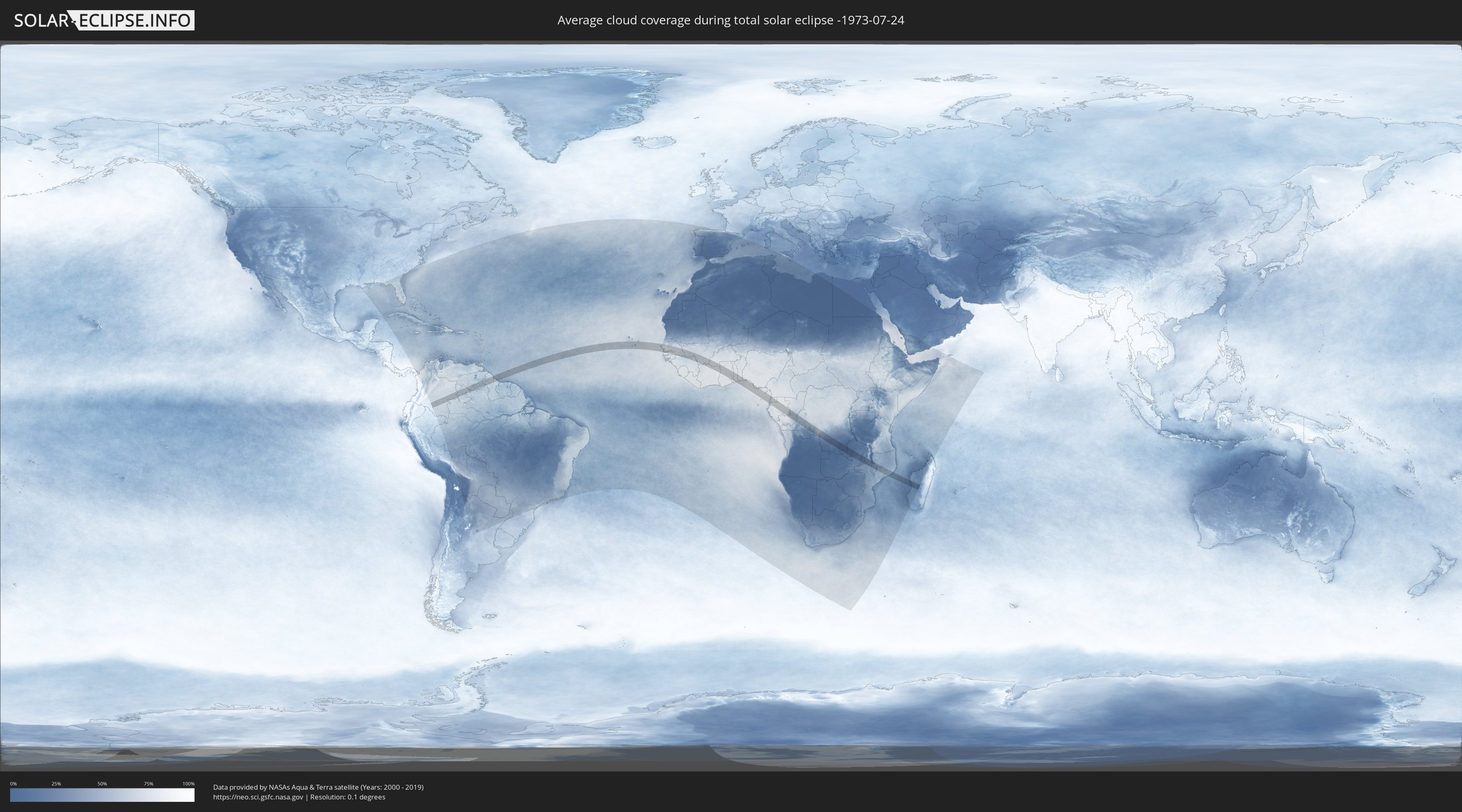
Wie wird das Wetter während der totalen Sonnenfinsternis am 24.07.-1973?
Wo ist der beste Ort, um die totale Sonnenfinsternis vom 24.07.-1973 zu beobachten?
Die folgenden Karten zeigen die durchschnittliche Bewölkung für den Tag, an dem die totale Sonnenfinsternis
stattfindet. Mit Hilfe der Karten lässt sich der Ort entlang des Finsternispfades eingrenzen,
der die besten Aussichen auf einen klaren wolkenfreien Himmel bietet.
Trotzdem muss man immer lokale Gegenenheiten beachten und sollte sich genau über das Wetter an seinem
gewählten Beobachtungsort informieren.
Die Daten stammen von den beiden NASA-Satelliten
AQUA und TERRA
und wurden über einen Zeitraum von 19 Jahren (2000 - 2019) gemittelt.

Detaillierte Länderkarten
 Kolumbien
 Brasilien
 Venezuela
 Guyana
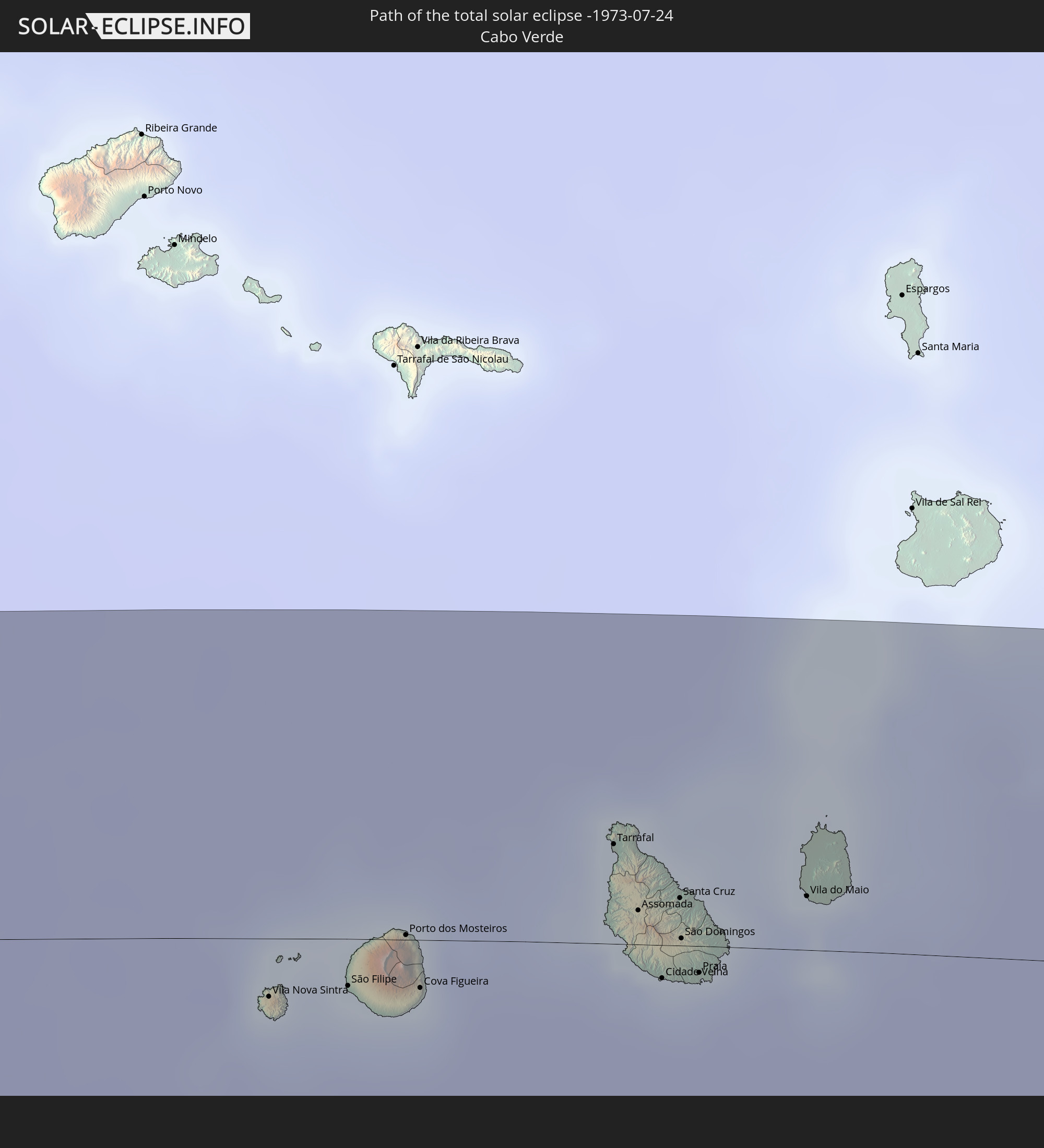
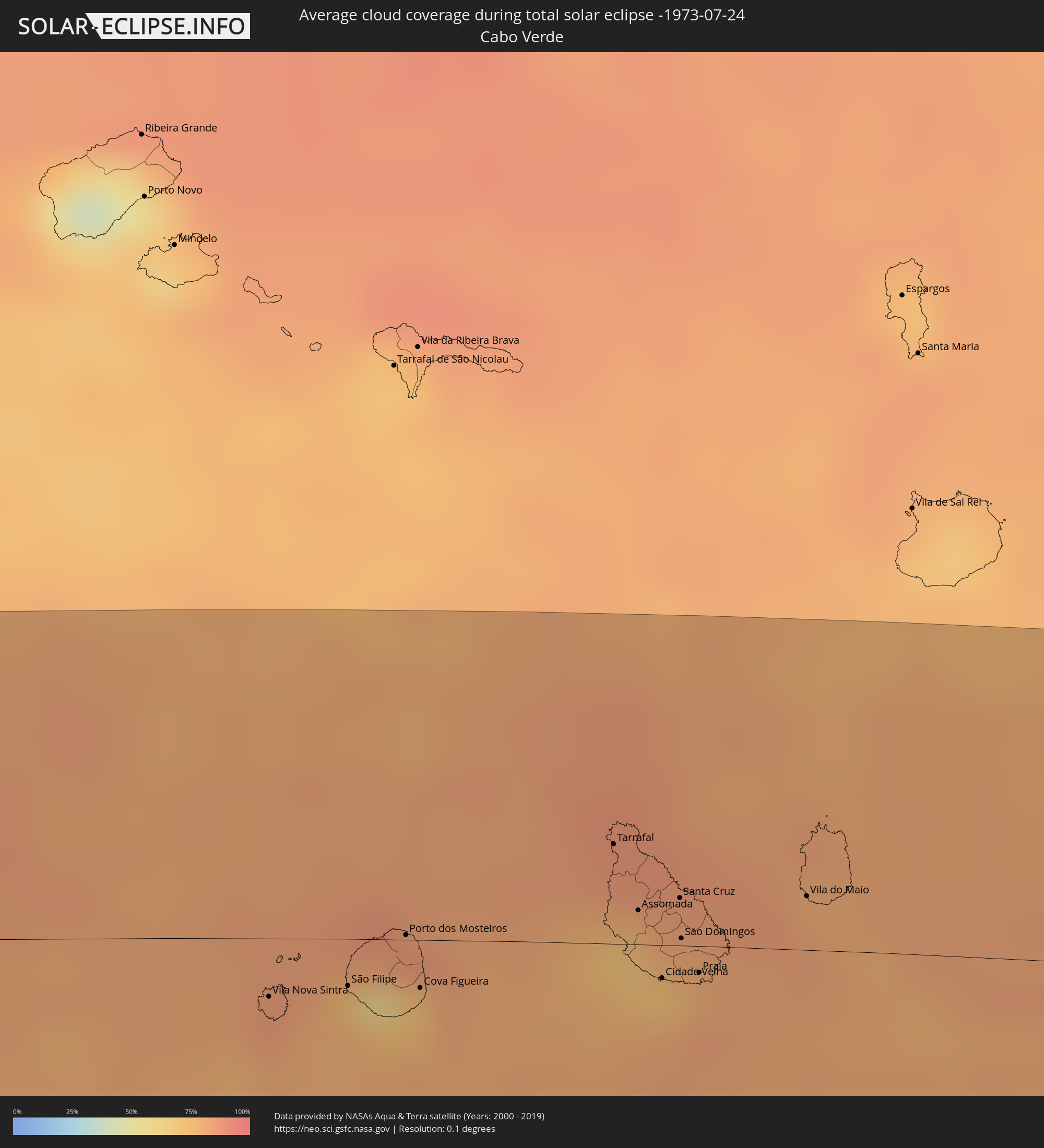 Kap Verde
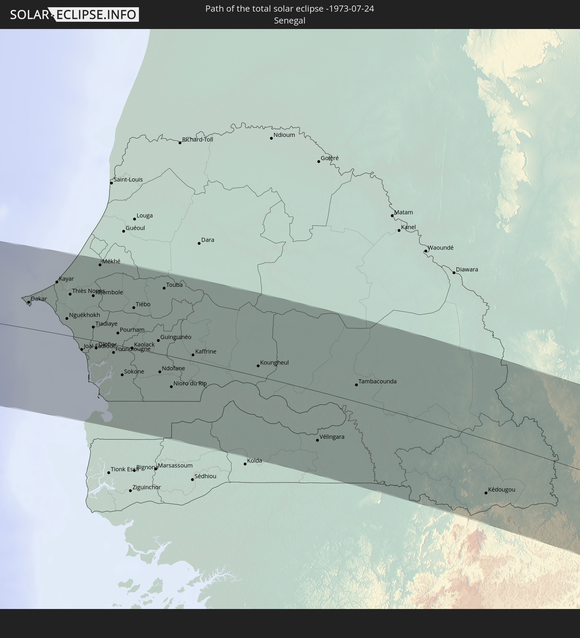
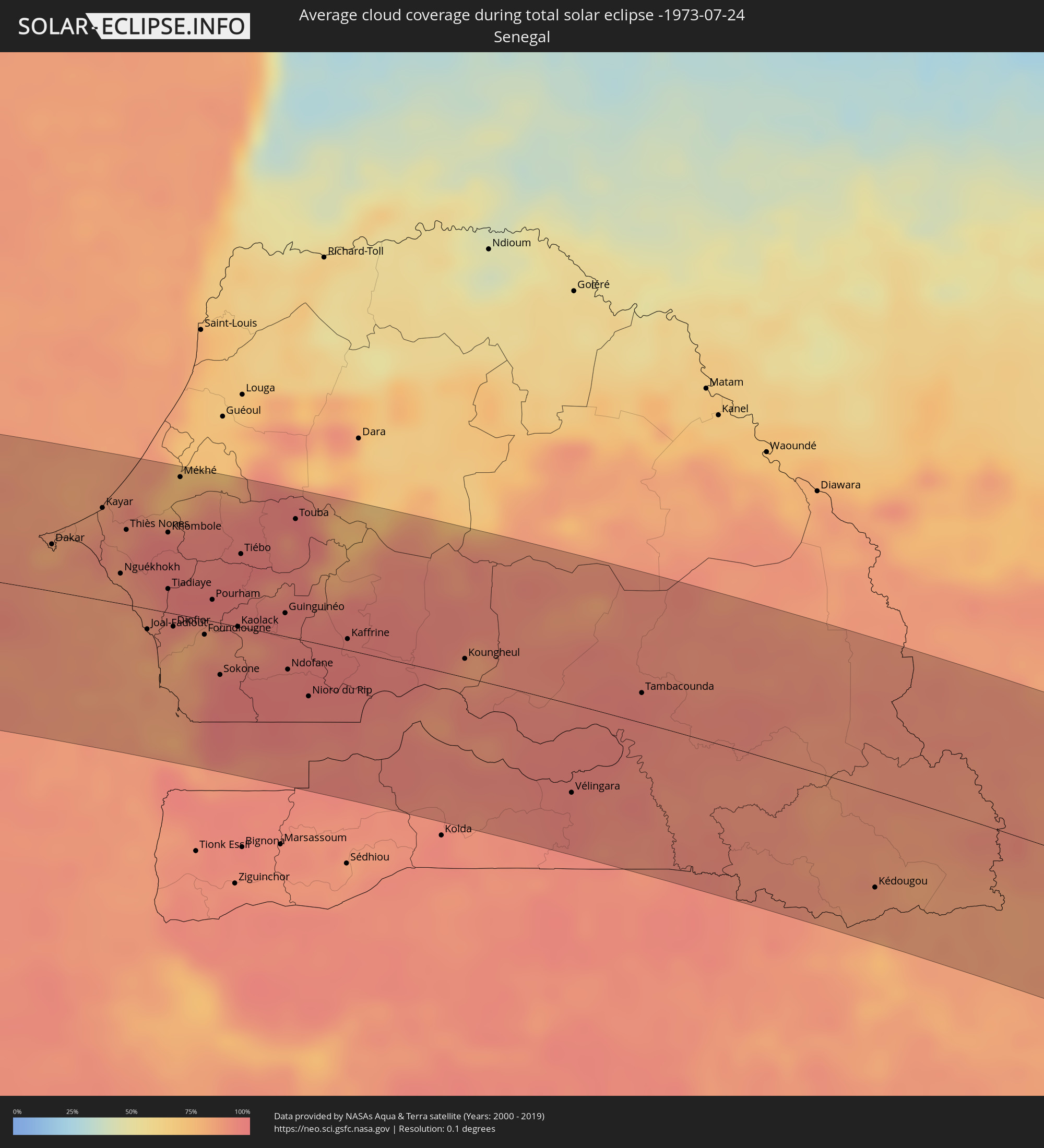 Senegal
 Gambia
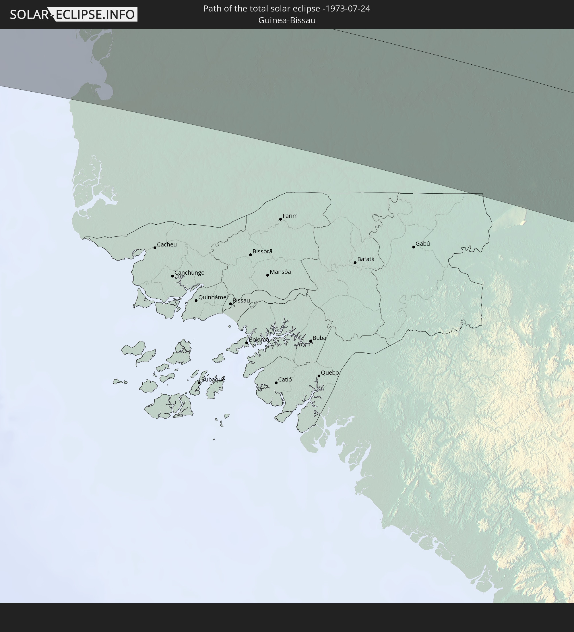
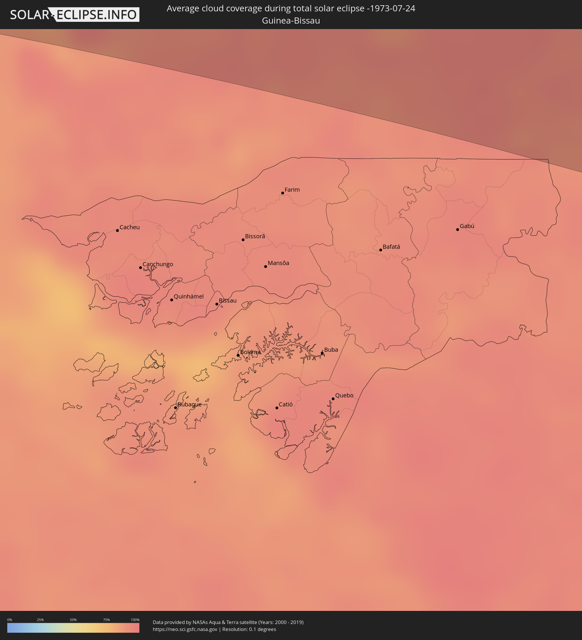 Guinea-Bissau
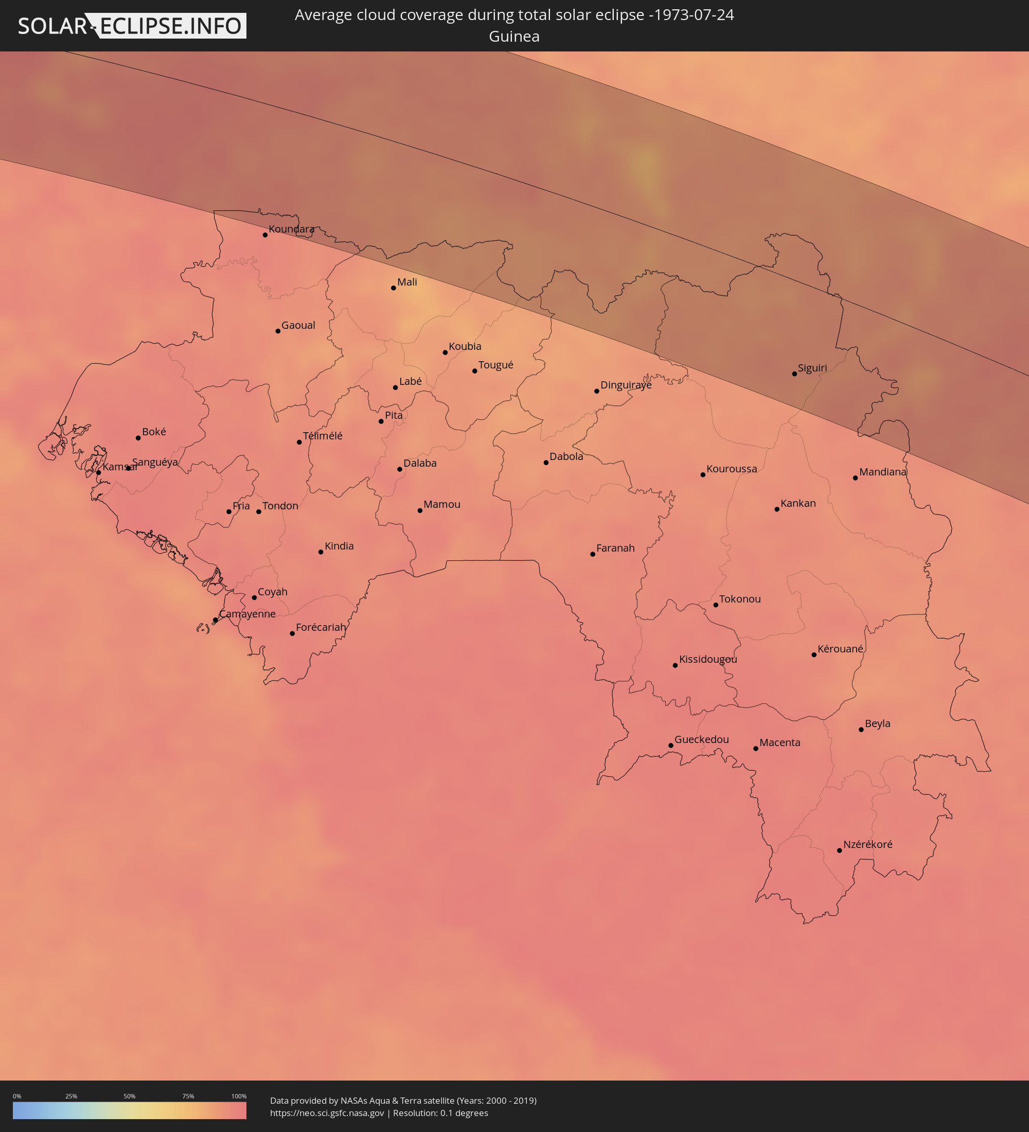 Guinea
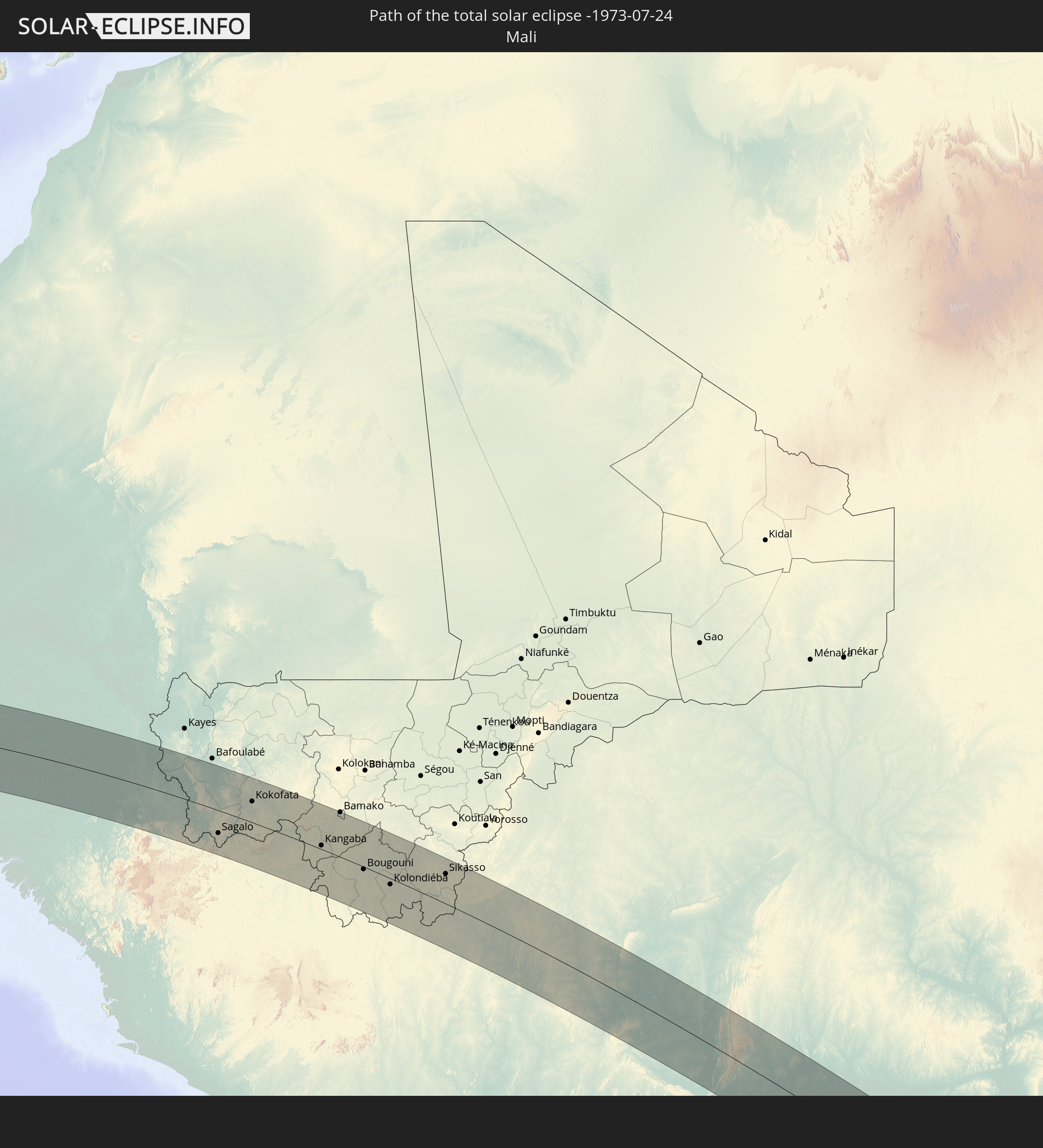
 Mali
Mali
 Elfenbeinküste
 Burkina Faso
 Ghana
Ghana
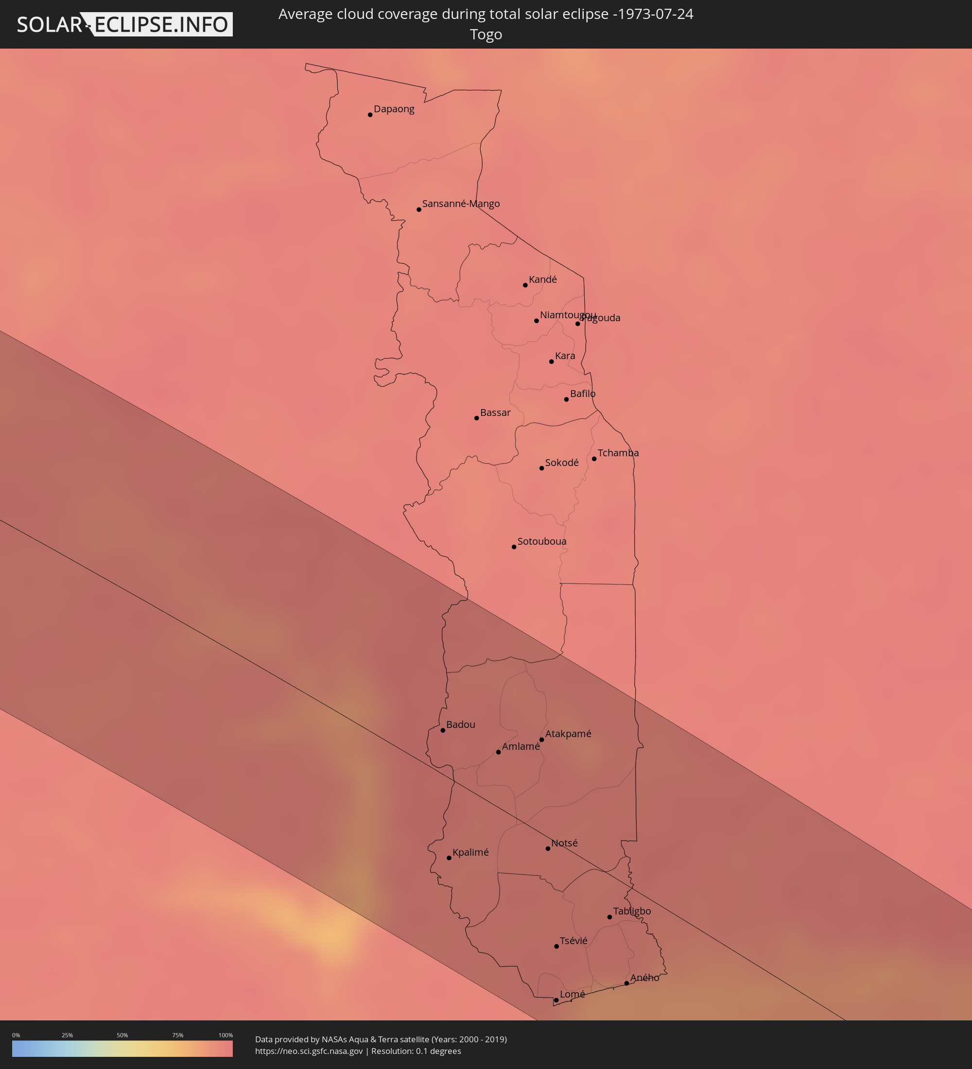 Togo
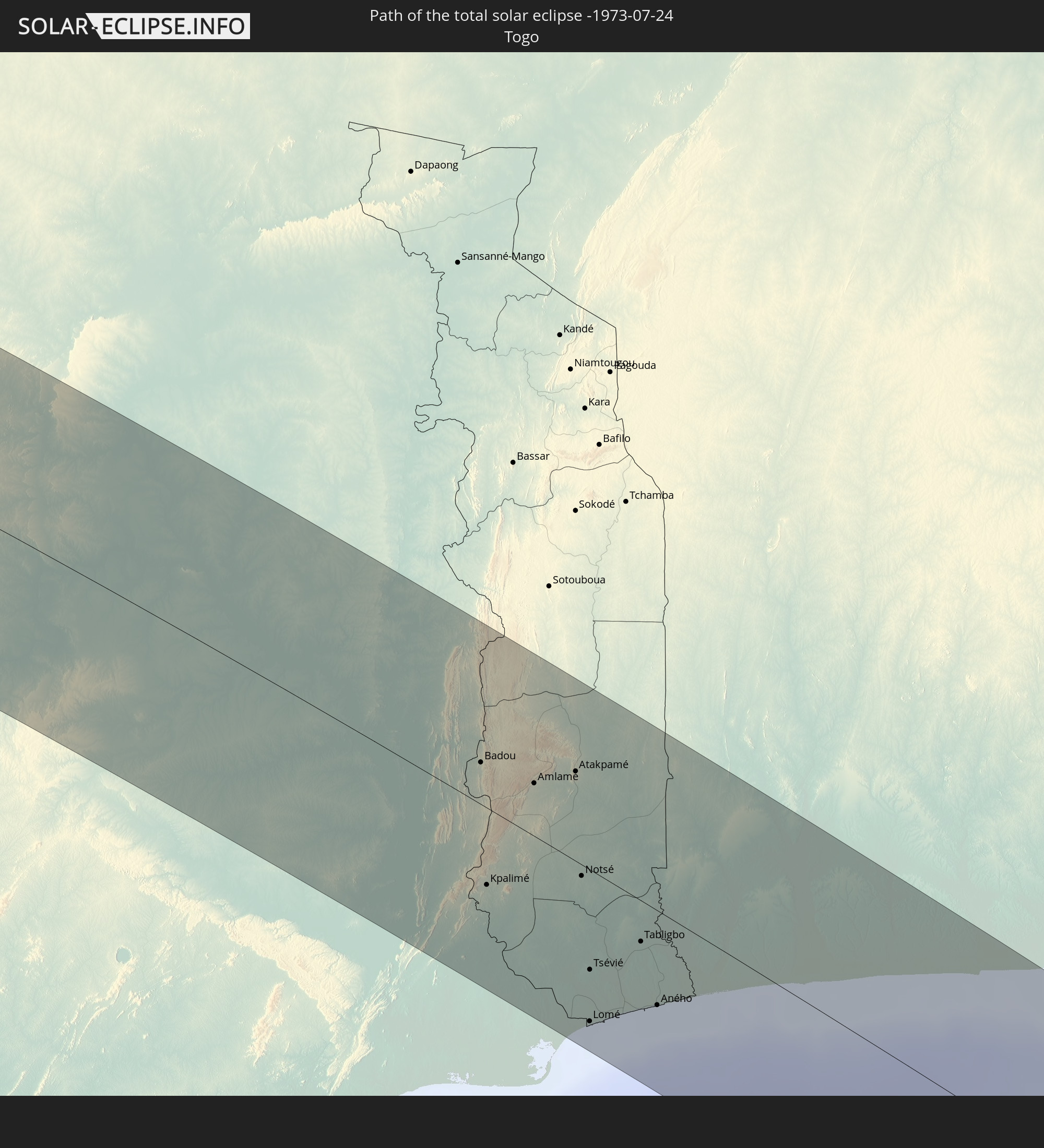
Togo
 Benin
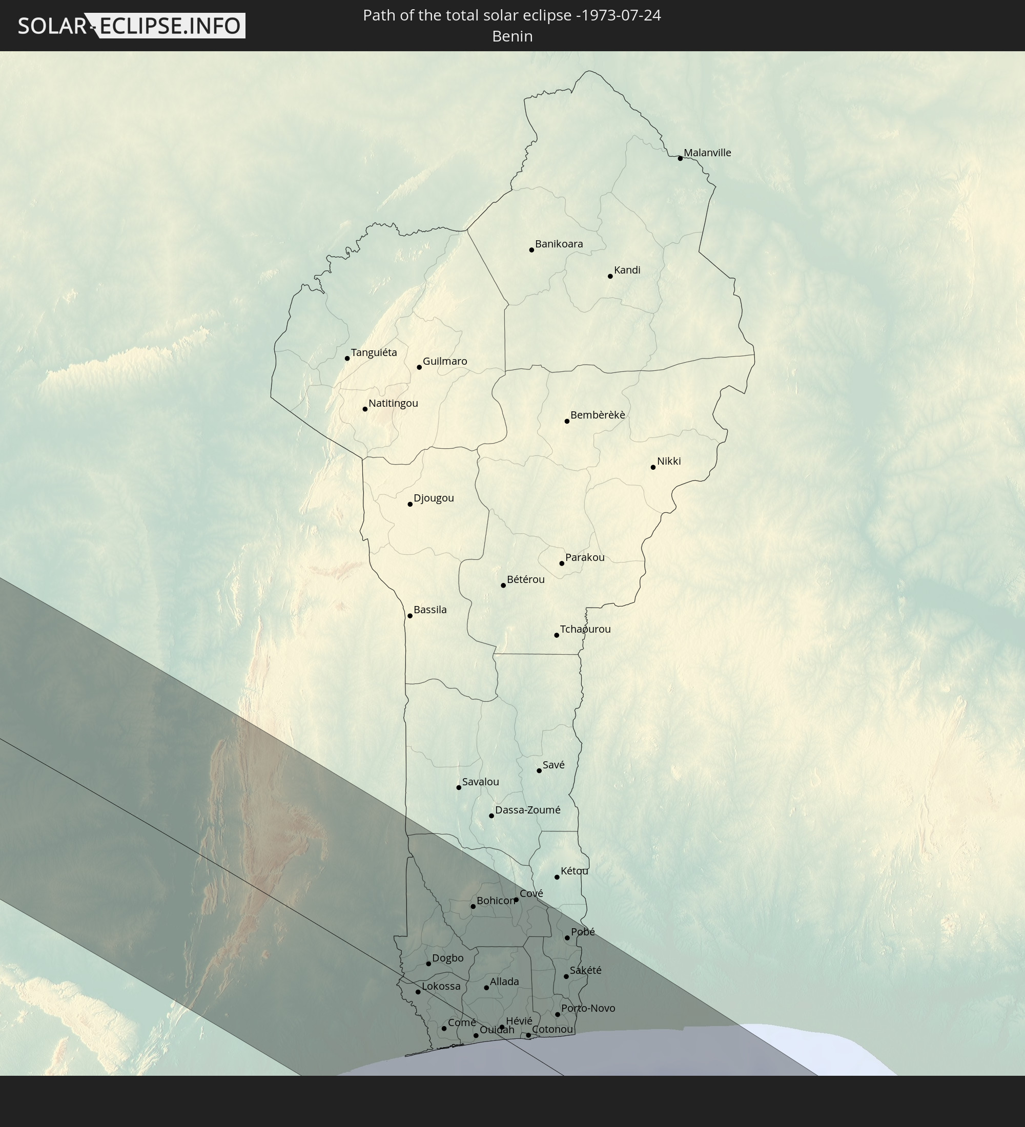
Benin
 Nigeria
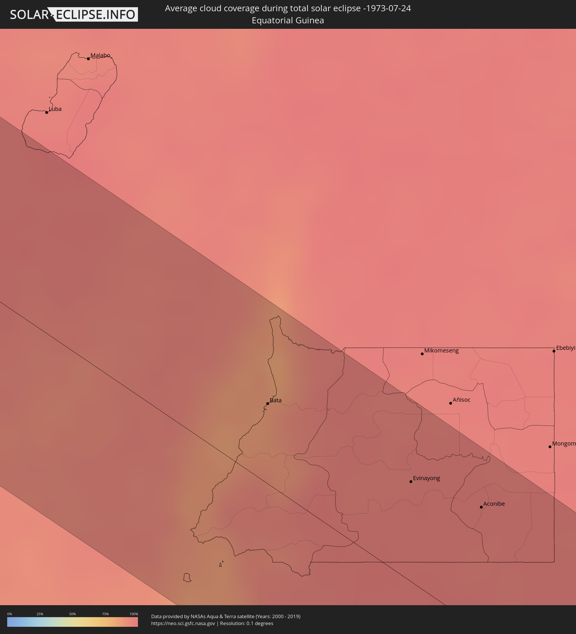 Äquatorialguinea
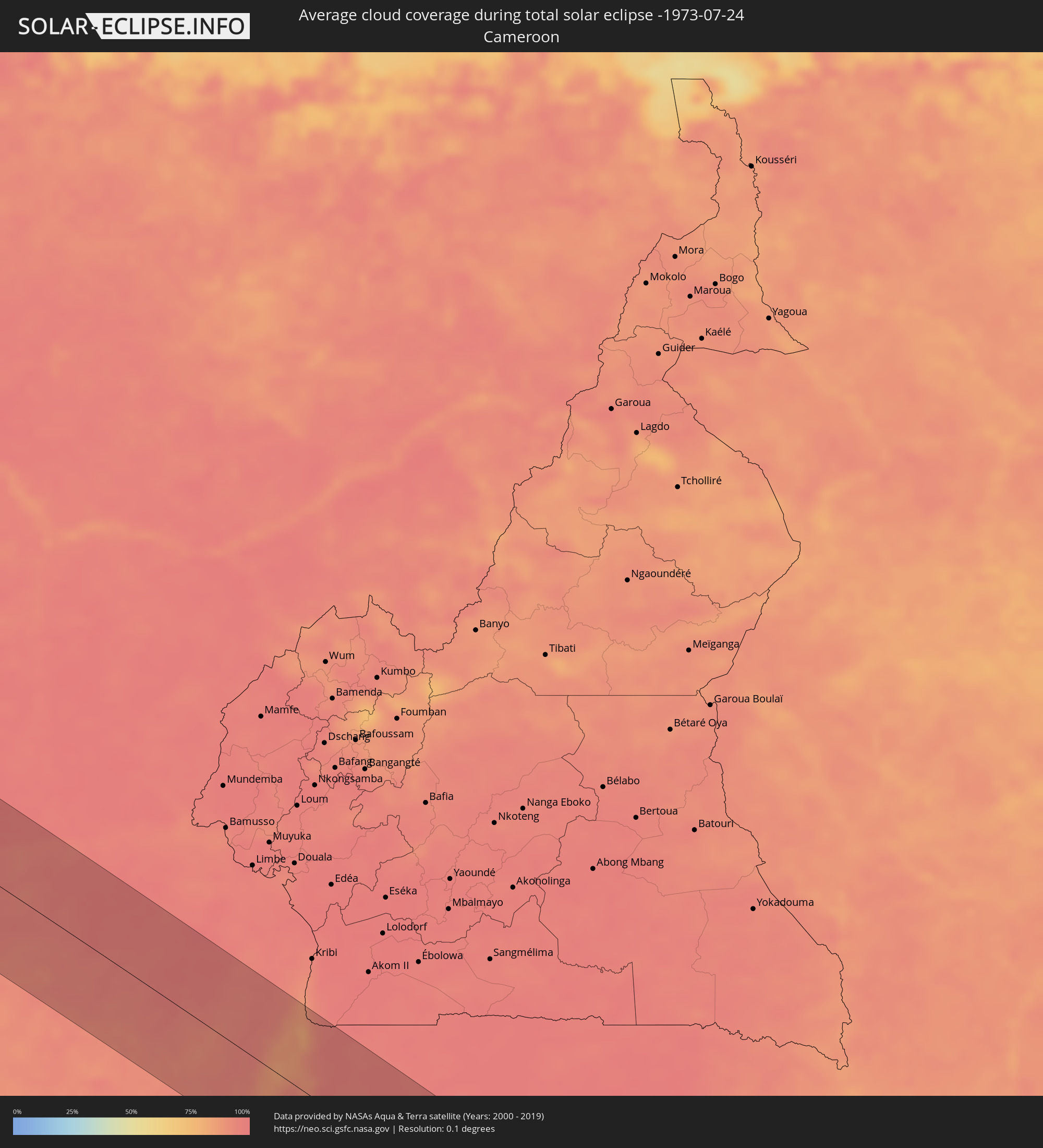 Kamerun
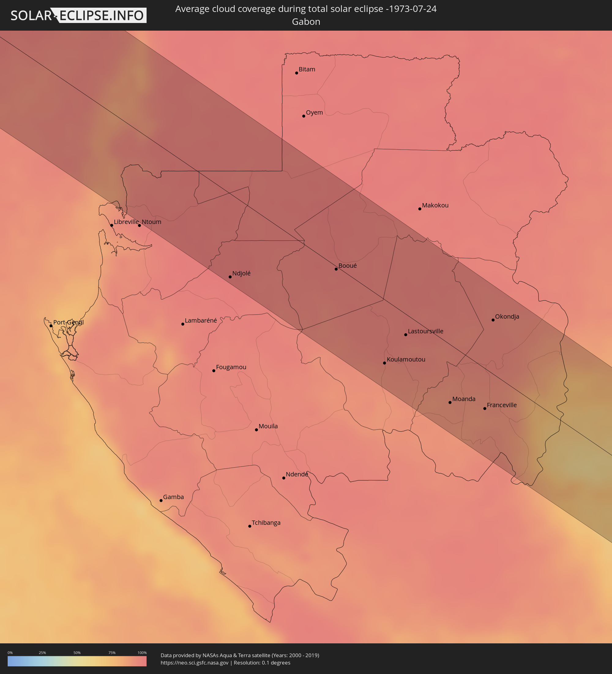 Gabun
Gabun
 Republik Kongo
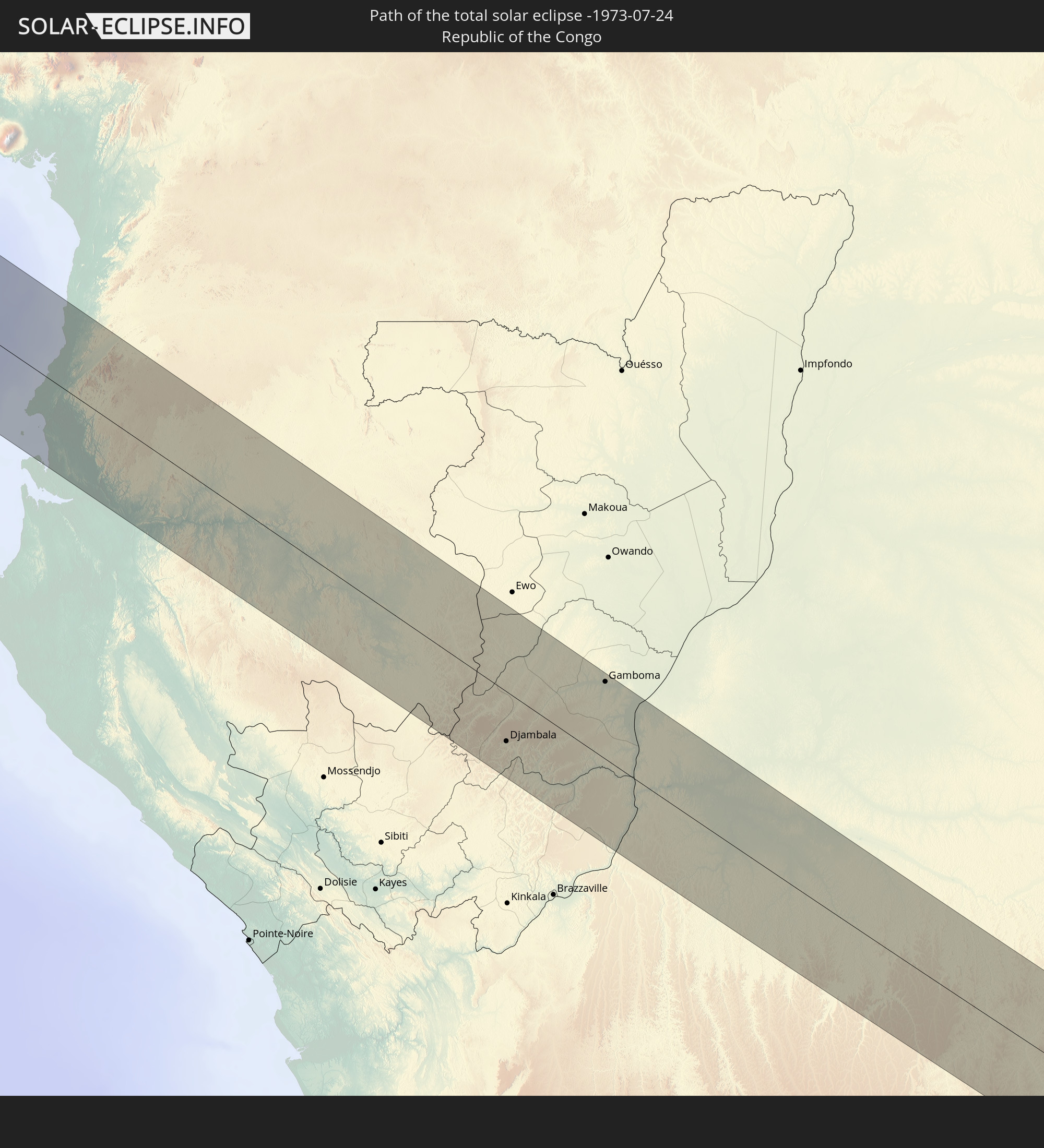
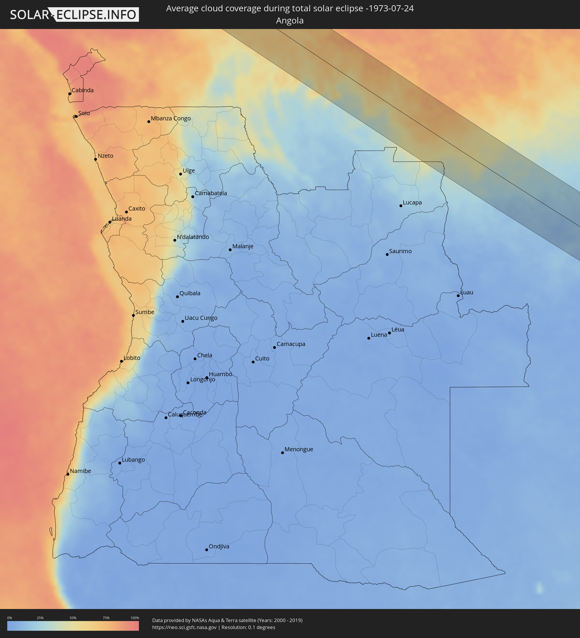 Angola
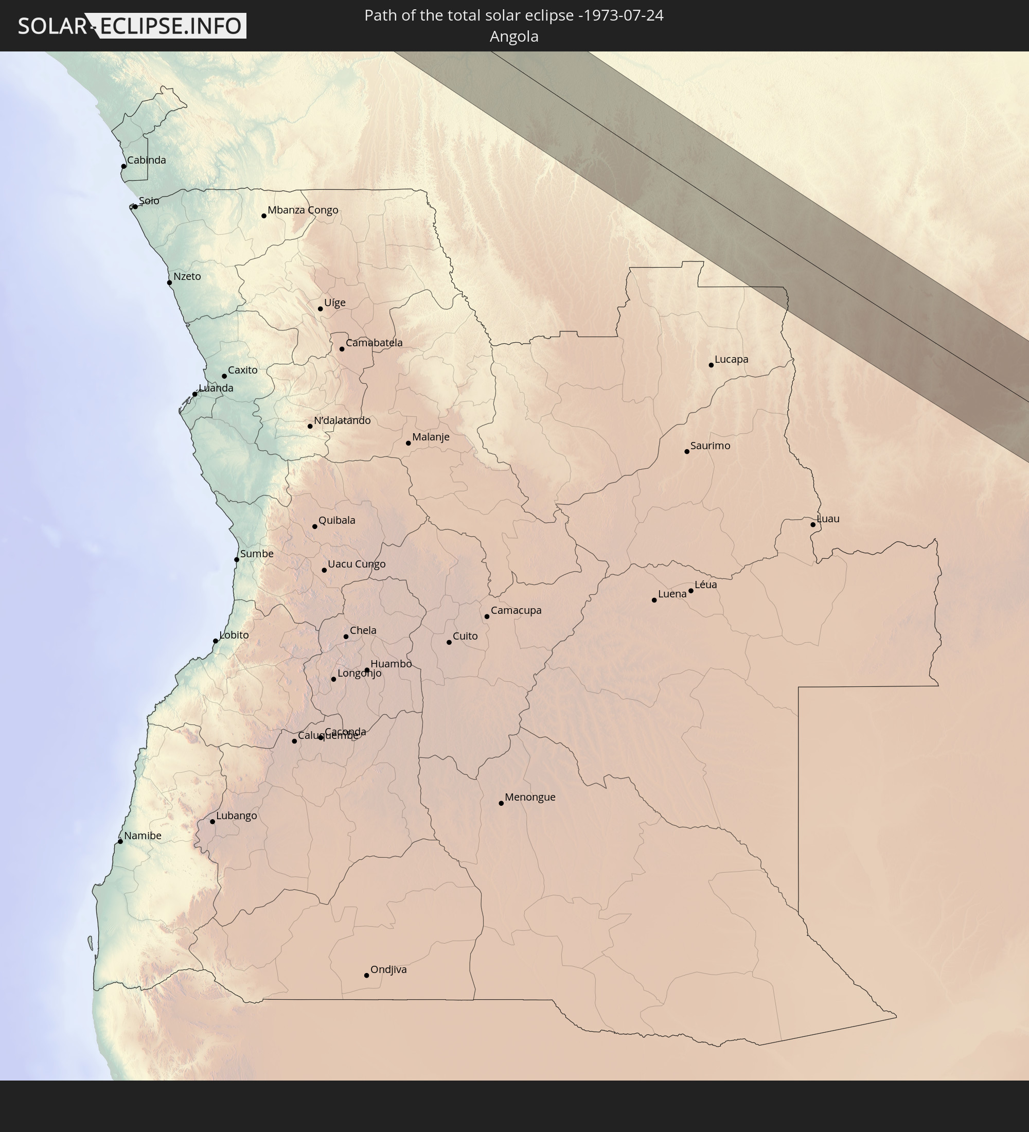
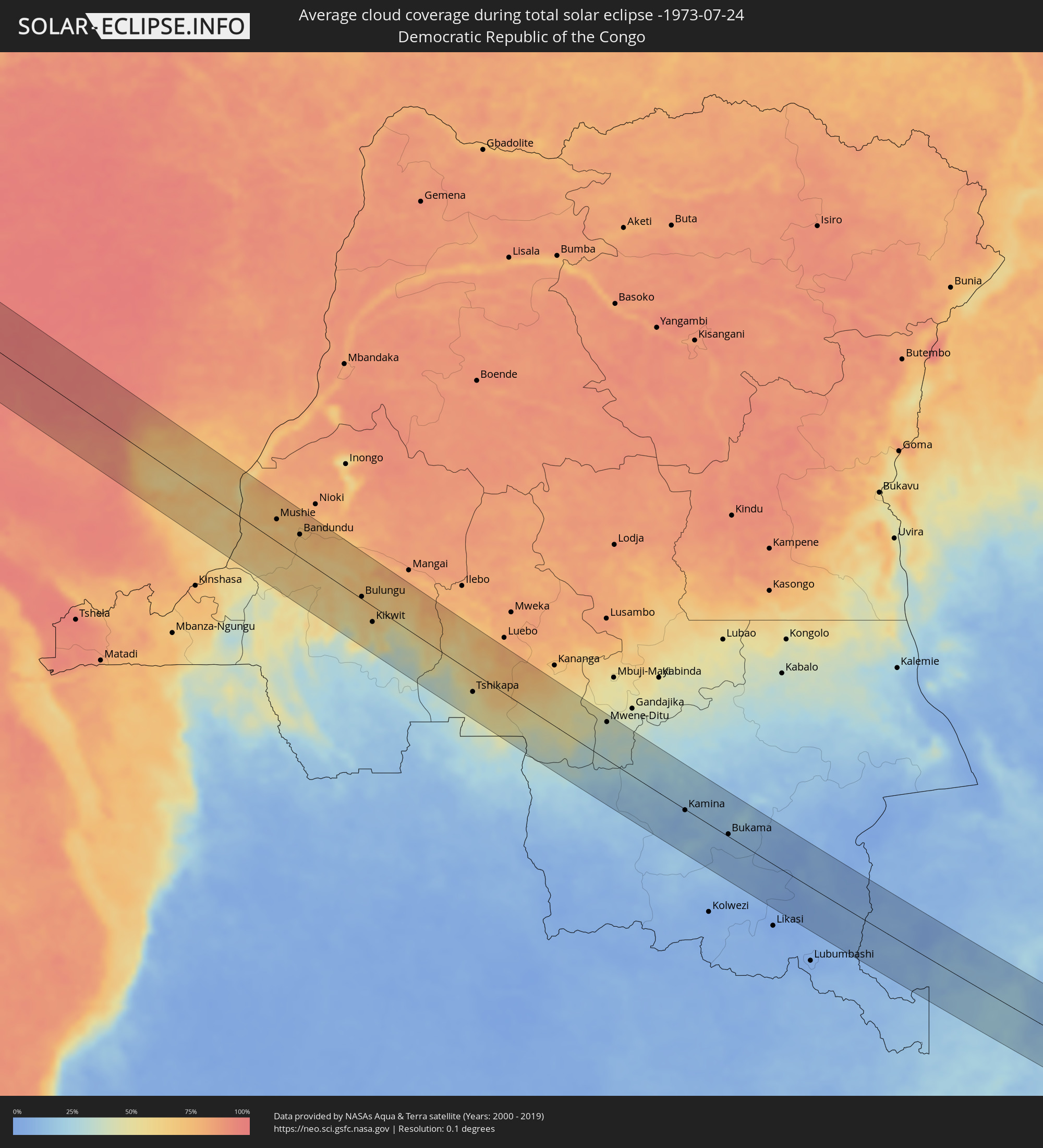 Demokratische Republik Kongo
 Sambia
 Mosambik
 Malawi
 Madagaskar
Orte im Finsternispfad
Die nachfolgene Tabelle zeigt Städte und Orte mit mehr als 5.000 Einwohnern, die sich im Finsternispfad befinden. Städte mit mehr als 100.000 Einwohnern sind dick gekennzeichnet. Mit einem Klick auf den Ort öffnet sich eine Detailkarte die die Lage des jeweiligen Ortes zusammen mit dem Verlauf der zentralen Finsternis präsentiert.
| Ort | Typ | Dauer der Verfinsterung | Ortszeit bei maximaler Verfinsterung | Entfernung zur Zentrallinie | Ø Bewölkung |
|
Mitú, Vaupés
|
total | - | 05:56:51 UTC-04:56 | 47 km | 82% |
|
Bartica, Cuyuni-Mazaruni
|
total | - | 07:05:05 UTC-03:52 | 21 km | 83% |
|
Anna Regina, Pomeroon-Supenaam
|
total | - | 07:05:20 UTC-03:52 | 62 km | 73% |
|
Linden, Upper Demerara-Berbice
|
total | - | 07:05:13 UTC-03:52 | 76 km | 86% |
|
Vreed-en-Hoop, Essequibo Islands-West Demerara
|
total | - | 07:05:26 UTC-03:52 | 3 km | 82% |
|
Georgetown, Demerara-Mahaica
|
total | - | 07:05:27 UTC-03:52 | 1 km | 82% |
|
Fort Wellington, Mahaica-Berbice
|
total | - | 07:05:44 UTC-03:52 | 65 km | 67% |
|
Rosignol, Mahaica-Berbice
|
total | - | 07:05:45 UTC-03:52 | 80 km | 71% |
|
São Filipe, São Filipe
|
total | - | 10:20:59 UTC-01:34 | 14 km | 78% |
|
Cova Figueira, Santa Catarina do Fogo
|
total | - | 10:21:32 UTC-01:34 | 14 km | 74% |
|
Tarrafal, Tarrafal
|
total | - | 10:22:54 UTC-01:34 | 30 km | 84% |
|
Picos, São Salvador do Mundo
|
total | - | 10:23:17 UTC-01:34 | 9 km | 78% |
|
Cidade Velha, Ribeira Grande de Santiago
|
total | - | 10:23:22 UTC-01:34 | 10 km | 80% |
|
Calheta, São Miguel
|
total | - | 10:23:21 UTC-01:34 | 20 km | 83% |
|
Santa Cruz, Santa Cruz
|
total | - | 10:23:27 UTC-01:34 | 14 km | 78% |
|
São Domingos, São Domingos
|
total | - | 10:23:29 UTC-01:34 | 2 km | 72% |
|
Praia, Praia
|
total | - | 10:23:39 UTC-01:34 | 8 km | 83% |
|
Vila do Maio, Maio
|
total | - | 10:24:25 UTC-01:34 | 16 km | 83% |
|
Dakar, Dakar
|
total | - | 11:59:02 UTC-00:16 | 32 km | 87% |
|
Thiès Nones, Thiès
|
total | - | 12:00:23 UTC-00:16 | 51 km | 88% |
|
Joal-Fadiout, Thiès
|
total | - | 12:01:11 UTC-00:16 | 14 km | 87% |
|
Bakau, Banjul
|
total | - | 12:02:07 UTC-00:16 | 86 km | 88% |
|
Abuko, Western
|
total | - | 12:02:14 UTC-00:16 | 94 km | 94% |
|
Barra, North Bank
|
total | - | 12:02:31 UTC-00:16 | 83 km | 87% |
|
Essau, North Bank
|
total | - | 12:02:33 UTC-00:16 | 82 km | 87% |
|
Lamin, North Bank
|
total | - | 12:02:57 UTC-00:16 | 95 km | 88% |
|
Pourham, Fatick
|
total | - | 12:02:17 UTC-00:16 | 15 km | 95% |
|
Kaolack, Kaolack
|
total | - | 12:02:53 UTC-00:16 | 0 km | 89% |
|
Tiébo, Diourbel
|
total | - | 12:02:38 UTC-00:16 | 49 km | 97% |
|
Touba, Diourbel
|
total | - | 12:03:30 UTC-00:16 | 81 km | 90% |
|
Farafenni, North Bank
|
total | - | 12:05:17 UTC-00:16 | 52 km | 93% |
|
Kaffrine, Kaffrine
|
total | - | 12:05:02 UTC-00:16 | 7 km | 97% |
|
Soma, Lower River
|
total | - | 12:05:35 UTC-00:16 | 65 km | 94% |
|
Bansang, Central River
|
total | - | 12:08:14 UTC-00:16 | 43 km | 94% |
|
Basse Santa Su, Upper River
|
total | - | 12:09:39 UTC-00:16 | 45 km | 95% |
|
Sabi, Upper River
|
total | - | 12:09:45 UTC-00:16 | 53 km | 95% |
|
Vélingara, Kolda
|
total | - | 12:10:04 UTC-00:16 | 59 km | 96% |
|
Tambacounda, Tambacounda
|
total | - | 12:10:53 UTC-00:16 | 20 km | 96% |
|
Youkounkoun, Boke
|
total | - | 12:13:36 UTC-00:16 | 97 km | 93% |
|
Diré
|
total | - | 12:20:17 UTC-00:16 | 52 km | 83% |
|
Sagalo, Kayes
|
total | - | 12:21:09 UTC-00:16 | 52 km | 83% |
|
Kokofata
|
total | - | 12:22:39 UTC-00:16 | 47 km | 88% |
|
Kita, Kayes
|
total | - | 12:23:49 UTC-00:16 | 81 km | 88% |
|
Siguiri, Kankan
|
total | - | 12:26:28 UTC-00:16 | 75 km | 87% |
|
Kangaba, Koulikoro
|
total | - | 12:28:05 UTC-00:16 | 8 km | 86% |
|
Bamako, Bamako
|
total | - | 12:28:28 UTC-00:16 | 99 km | 87% |
|
Bougouni, Sikasso
|
total | - | 12:31:19 UTC-00:16 | 5 km | 92% |
|
Kolondiéba, Sikasso
|
total | - | 12:33:22 UTC-00:16 | 13 km | 93% |
|
Tengrela, Savanes
|
total | - | 12:35:26 UTC-00:16 | 53 km | 93% |
|
Sikasso, Sikasso
|
total | - | 12:36:30 UTC-00:16 | 65 km | 92% |
|
Ferkessédougou, Savanes
|
total | - | 12:39:51 UTC-00:16 | 86 km | 95% |
|
Orodara, Hauts-Bassins
|
total | - | 12:38:56 UTC-00:16 | 63 km | 95% |
|
Banfora, Cascades
|
total | - | 12:39:46 UTC-00:16 | 39 km | 95% |
|
Gaoua, Sud-Ouest
|
total | - | 12:44:12 UTC-00:16 | 80 km | 96% |
|
Bouna, Zanzan
|
total | - | 12:46:09 UTC-00:16 | 8 km | 96% |
|
Batié, Sud-Ouest
|
total | - | 12:45:35 UTC-00:16 | 56 km | 96% |
|
Wa, Upper West
|
total | - | 13:01:42 UTC-00:00 | 95 km | 96% |
|
Kintampo, Brong-Ahafo
|
total | - | 13:06:11 UTC-00:00 | 60 km | 94% |
|
Salaga, Northern
|
total | - | 13:08:34 UTC-00:00 | 53 km | 95% |
|
Kete Krachi
|
total | - | 13:10:41 UTC-00:00 | 6 km | 85% |
|
Kpandae
|
total | - | 13:09:55 UTC-00:00 | 73 km | 96% |
|
Kpandu, Volta
|
total | - | 13:12:31 UTC-00:00 | 51 km | 92% |
|
Ho, Volta
|
total | - | 13:13:26 UTC-00:00 | 79 km | 94% |
|
Hohoe, Volta
|
total | - | 13:12:45 UTC-00:00 | 26 km | 97% |
|
Badou, Plateaux
|
total | - | 12:57:14 UTC-00:16 | 22 km | 97% |
|
Kpalimé, Plateaux
|
total | - | 12:58:11 UTC-00:16 | 41 km | 95% |
|
Amlamé, Plateaux
|
total | - | 12:58:05 UTC-00:16 | 28 km | 95% |
|
Atakpamé, Plateaux
|
total | - | 12:58:33 UTC-00:16 | 48 km | 95% |
|
Notsé, Plateaux
|
total | - | 12:59:22 UTC-00:16 | 6 km | 95% |
|
Lomé, Maritime
|
total | - | 13:00:30 UTC-00:16 | 81 km | 85% |
|
Tsévié, Maritime
|
total | - | 13:00:09 UTC-00:16 | 53 km | 96% |
|
Tabligbo, Maritime
|
total | - | 13:00:37 UTC-00:16 | 22 km | 95% |
|
Vogan, Maritime
|
total | - | 13:01:00 UTC-00:16 | 44 km | 85% |
|
Aného, Maritime
|
total | - | 13:01:16 UTC-00:16 | 50 km | 83% |
|
Lokossa, Mono
|
total | - | 13:30:45 UTC+00:13 | 4 km | 94% |
|
Dogbo, Kouffo
|
total | - | 13:30:41 UTC+00:13 | 17 km | 95% |
|
Comé, Mono
|
total | - | 13:31:25 UTC+00:13 | 16 km | 89% |
|
Bohicon, Zou
|
total | - | 13:30:52 UTC+00:13 | 67 km | 96% |
|
Ouidah, Atlantique
|
total | - | 13:31:57 UTC+00:13 | 9 km | 87% |
|
Cové, Zou
|
total | - | 13:31:26 UTC+00:13 | 87 km | 95% |
|
Cotonou, Littoral
|
total | - | 13:32:41 UTC+00:13 | 11 km | 90% |
|
Porto-Novo, Ouémé
|
total | - | 13:32:56 UTC+00:13 | 34 km | 90% |
|
Sakété, Plateau
|
total | - | 13:32:46 UTC+00:13 | 60 km | 96% |
|
Pobé, Plateau
|
total | - | 13:32:28 UTC+00:13 | 83 km | 96% |
|
Idi Iroko, Ogun
|
total | - | 13:33:03 UTC+00:13 | 55 km | 94% |
|
Badagry, Lagos
|
total | - | 13:33:40 UTC+00:13 | 43 km | 86% |
|
Ado Odo, Ogun
|
total | - | 13:33:32 UTC+00:13 | 63 km | 94% |
|
Ilaro, Ogun
|
total | - | 13:33:21 UTC+00:13 | 95 km | 96% |
|
Ikeja, Lagos
|
total | - | 13:34:26 UTC+00:13 | 87 km | 97% |
|
Makoko, Lagos
|
total | - | 13:34:40 UTC+00:13 | 80 km | 95% |
|
Lagos, Lagos
|
total | - | 13:34:44 UTC+00:13 | 77 km | 95% |
|
Ebute Ikorodu, Lagos
|
total | - | 13:34:45 UTC+00:13 | 96 km | 94% |
|
Twon-Brass, Bayelsa
|
total | - | 13:43:17 UTC+00:13 | 48 km | 96% |
|
Bata, Litoral
|
total | - | 13:52:37 UTC+00:13 | 40 km | 90% |
|
Evinayong, Centro Sur
|
total | - | 13:54:24 UTC+00:13 | 50 km | 97% |
|
Ndjolé, Moyen-Ogooué
|
total | - | 13:56:29 UTC+00:13 | 85 km | 98% |
|
Aconibe, Wele-Nzas
|
total | - | 13:55:11 UTC+00:13 | 62 km | 97% |
|
Booué, Ogooué-Ivindo
|
total | - | 13:58:15 UTC+00:13 | 3 km | 97% |
|
Koulamoutou, Ogooué-Lolo
|
total | - | 14:00:07 UTC+00:13 | 65 km | 92% |
|
Lastoursville, Ogooué-Lolo
|
total | - | 14:00:10 UTC+00:13 | 21 km | 94% |
|
Mounana, Haut-Ogooué
|
total | - | 14:01:25 UTC+00:13 | 47 km | 90% |
|
Moanda, Haut-Ogooué
|
total | - | 14:01:38 UTC+00:13 | 59 km | 90% |
|
Franceville, Haut-Ogooué
|
total | - | 14:02:15 UTC+00:13 | 41 km | 89% |
|
Okondja, Haut-Ogooué
|
total | - | 14:01:26 UTC+00:13 | 55 km | 95% |
|
Djambala, Plateaux
|
total | - | 14:04:44 UTC+00:13 | 51 km | 71% |
|
Gamboma, Plateaux
|
total | - | 14:05:36 UTC+00:13 | 80 km | 68% |
|
Bolobo, Bandundu
|
total | - | 14:06:20 UTC+00:13 | 77 km | 53% |
|
Mushie, Bandundu
|
total | - | 14:07:58 UTC+00:13 | 41 km | 67% |
|
Bandundu, Bandundu
|
total | - | 14:08:47 UTC+00:13 | 42 km | 70% |
|
Bulungu, Bandundu
|
total | - | 14:11:13 UTC+00:13 | 4 km | 65% |
|
Kikwit, Bandundu
|
total | - | 14:11:50 UTC+00:13 | 29 km | 56% |
|
Tshikapa, Kasaï-Occidental
|
total | - | 16:11:41 UTC+02:10 | 35 km | 48% |
|
Mwene-Ditu, Kasaï-Oriental
|
total | - | 16:14:33 UTC+02:10 | 69 km | 37% |
|
Kamina, Katanga
|
total | - | 16:16:51 UTC+02:10 | 2 km | 13% |
|
Bukama, Katanga
|
total | - | 16:17:45 UTC+02:10 | 4 km | 12% |
|
Mansa, Luapula
|
total | - | 16:20:44 UTC+02:10 | 12 km | 8% |
|
Samfya, Luapula
|
total | - | 16:21:12 UTC+02:10 | 10 km | 7% |
|
Kataba, Copperbelt
|
total | - | 16:21:32 UTC+02:10 | 27 km | 11% |
|
Mpika, Muchinga Province
|
total | - | 16:22:24 UTC+02:10 | 69 km | 14% |
|
Mchinji, Central Region
|
total | - | 16:23:43 UTC+02:10 | 43 km | 28% |
|
Kasungu, Central Region
|
total | - | 16:23:44 UTC+02:10 | 63 km | 26% |
|
Lilongwe, Central Region
|
total | - | 16:24:08 UTC+02:10 | 11 km | 28% |
|
Dedza, Central Region
|
total | - | 16:24:28 UTC+02:10 | 22 km | 38% |
|
Salima, Central Region
|
total | - | 16:24:21 UTC+02:10 | 43 km | 17% |
|
Monkey Bay, Southern Region
|
total | - | 16:24:36 UTC+02:10 | 37 km | 25% |
|
Balaka, Southern Region
|
total | - | 16:24:50 UTC+02:10 | 48 km | 39% |
|
Liwonde, Southern Region
|
total | - | 16:24:57 UTC+02:10 | 43 km | 38% |
|
Mangochi, Southern Region
|
total | - | 16:24:49 UTC+02:10 | 17 km | 31% |
|
Zomba, Southern Region
|
total | - | 16:25:03 UTC+02:10 | 69 km | 43% |
|
Cuamba, Niassa
|
total | - | 16:25:19 UTC+02:10 | 51 km | 42% |
|
Mutuáli, Nampula
|
total | - | 16:25:28 UTC+02:10 | 68 km | 43% |
|
Belo sur Tsiribihina, Menabe
|
total | - | 16:44:11 UTC+02:27 | 48 km | 20% |
|
Miandrivazo, Menabe
|
total | - | 16:44:13 UTC+02:27 | 10 km | 21% |