Totale Sonnenfinsternis vom 30.03.0051
| Wochentag: | Donnerstag |
| Maximale Dauer der Verfinsterung: | 04m21s |
| Maximale Breite des Finsternispfades: | 305 km |
| Saroszyklus: | 59 |
| Bedeckungsgrad: | 100% |
| Magnitude: | 1.0609 |
| Gamma: | -0.7681 |
Wo kann man die Sonnenfinsternis vom 30.03.0051 sehen?
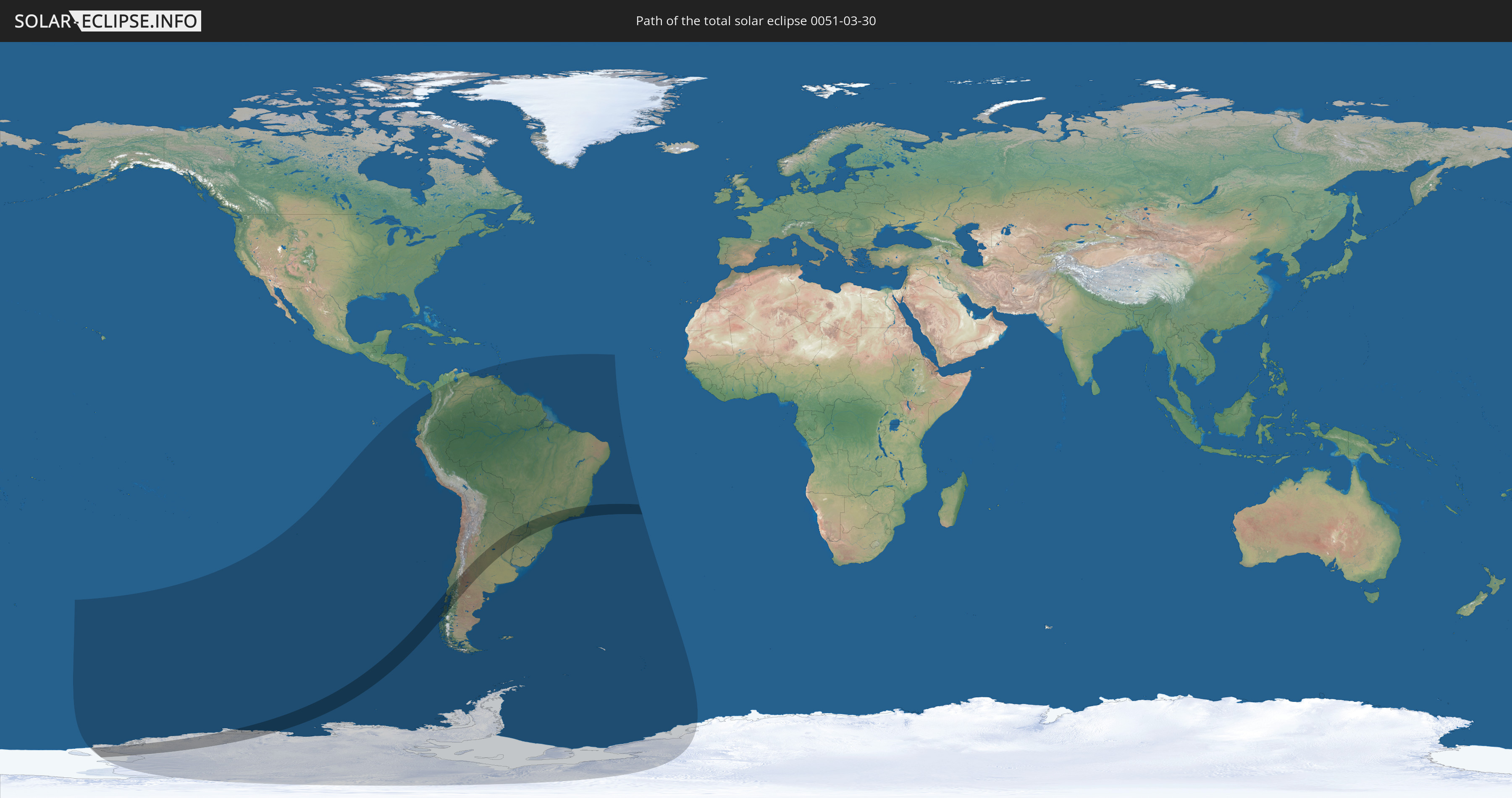
Die Sonnenfinsternis am 30.03.0051 kann man in 20 Ländern als partielle Sonnenfinsternis beobachten.
Der Finsternispfad verläuft durch 5 Länder. Nur in diesen Ländern ist sie als totale Sonnenfinsternis zu sehen.
In den folgenden Ländern ist die Sonnenfinsternis total zu sehen
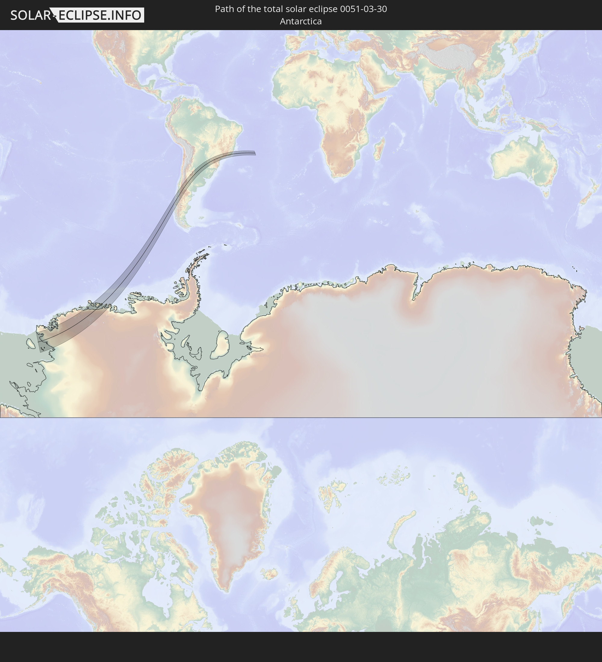 Antarktika
 Chile
Chile
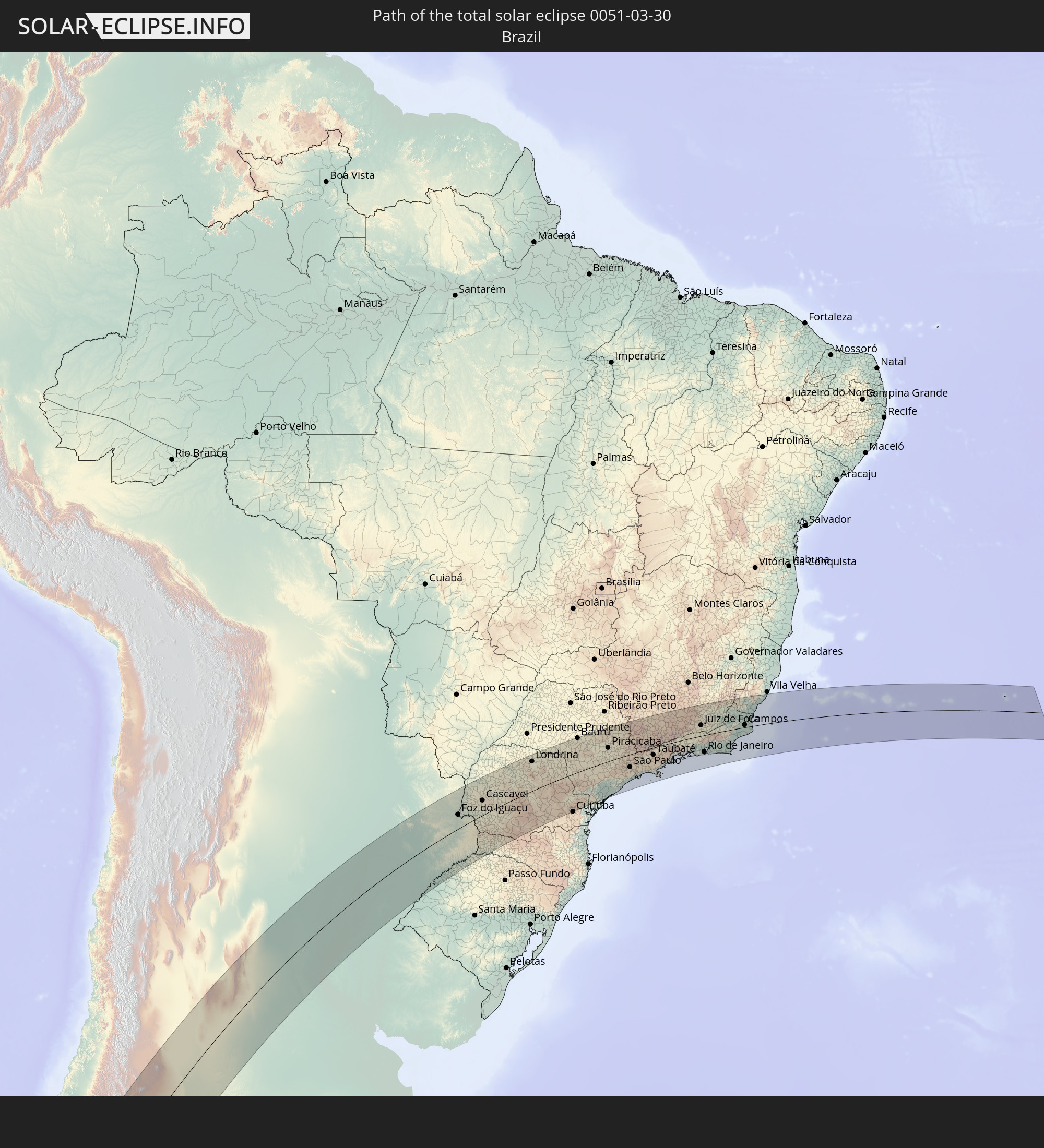 Brasilien
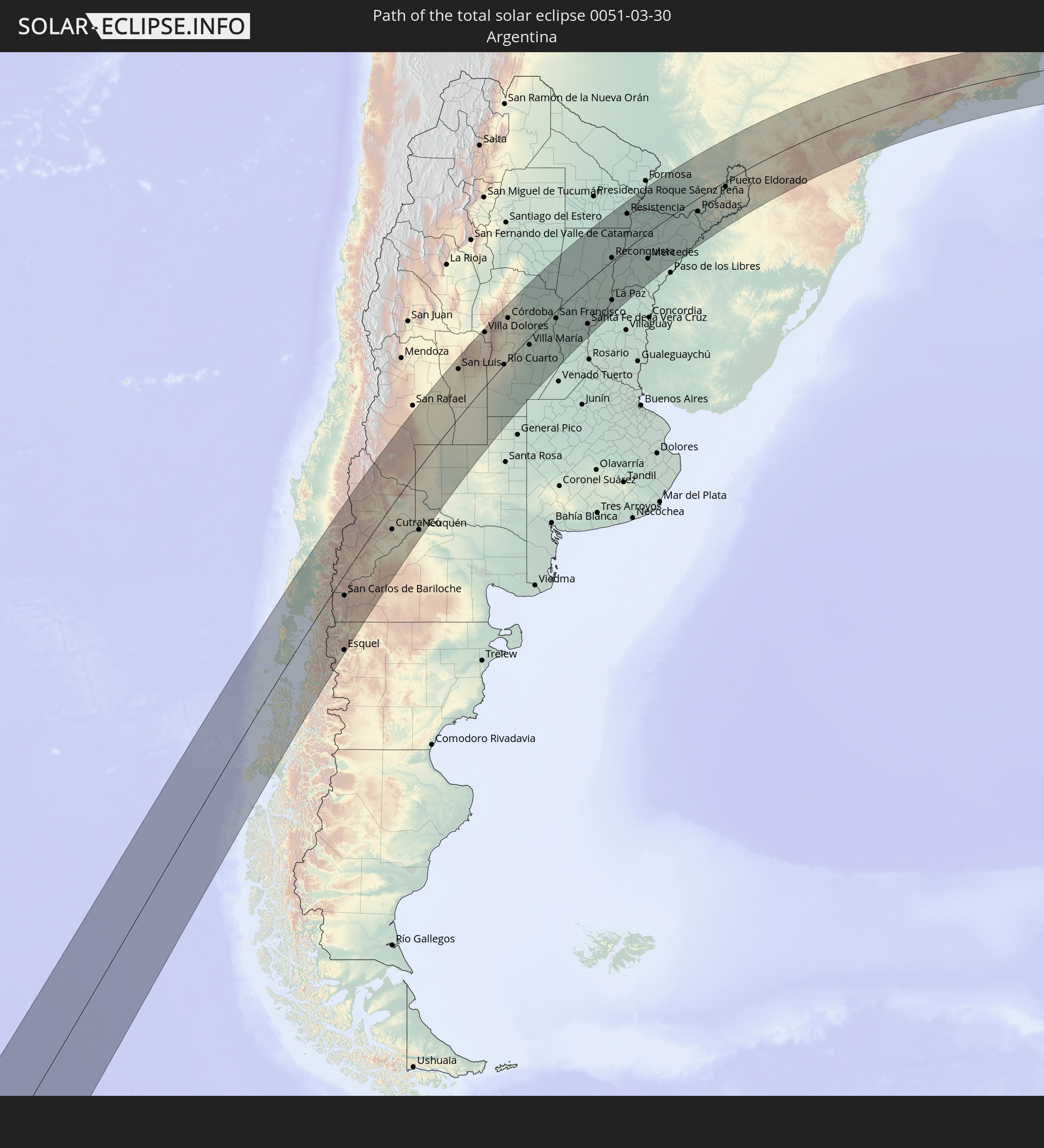 Argentinien
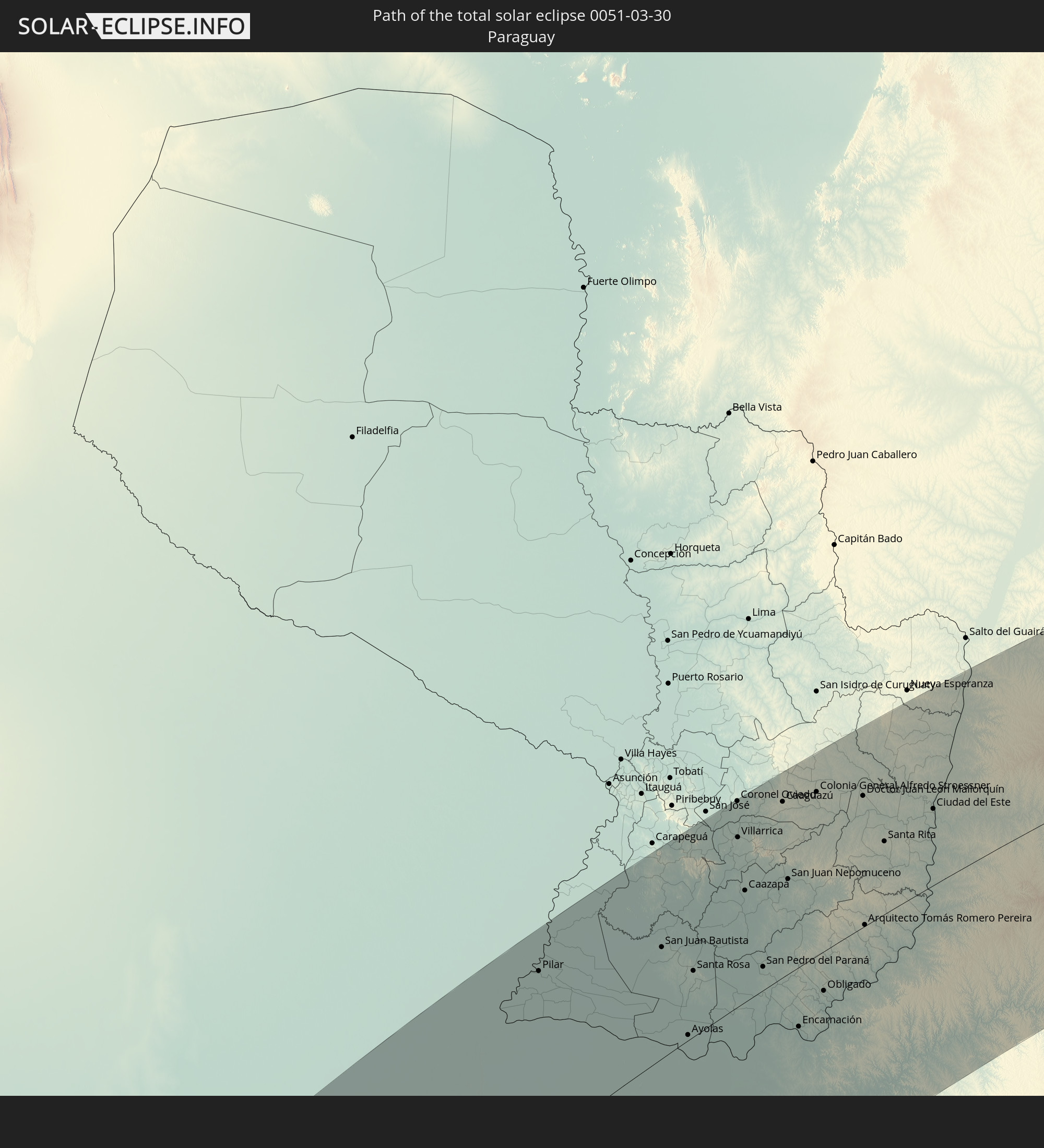 Paraguay
In den folgenden Ländern ist die Sonnenfinsternis partiell zu sehen


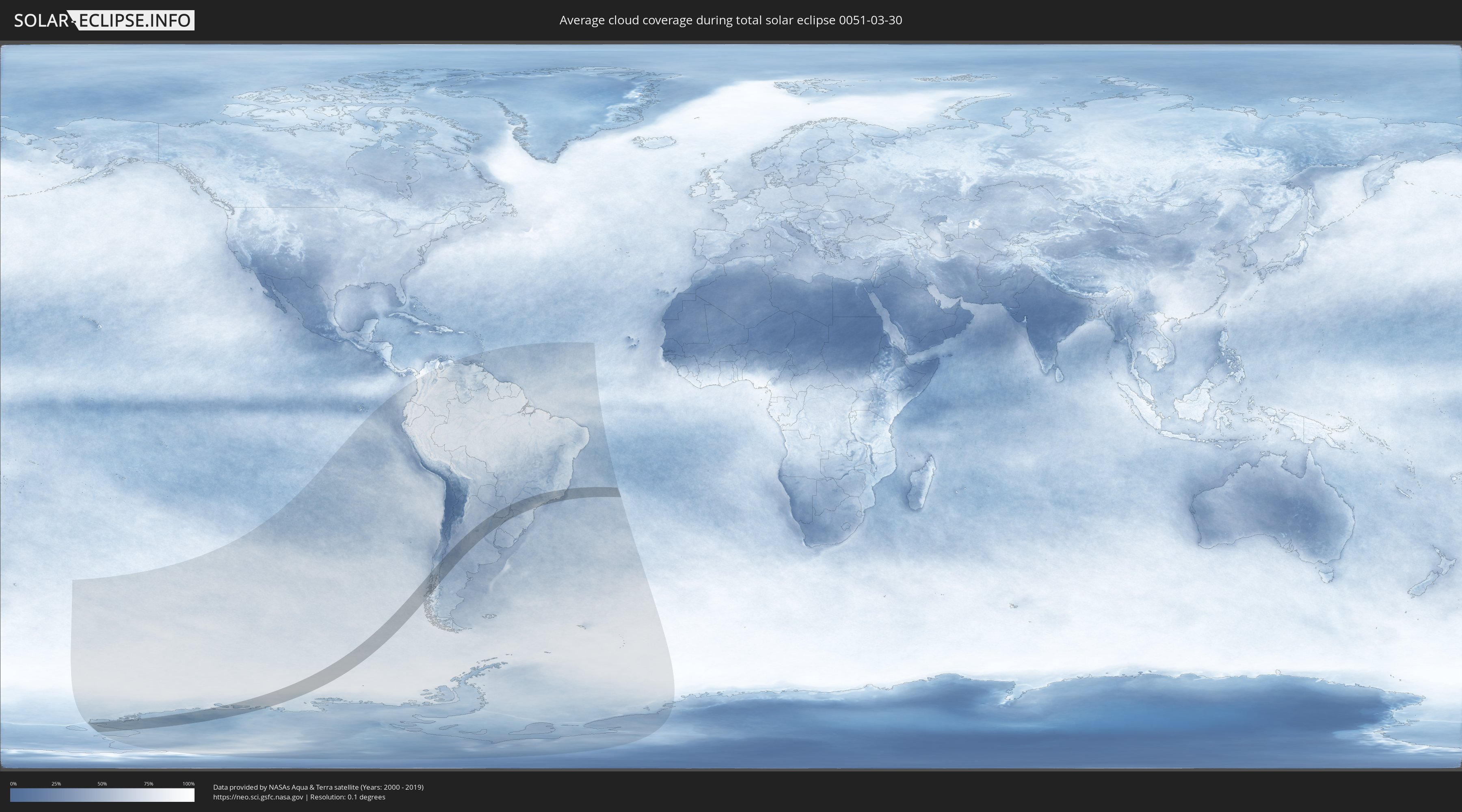
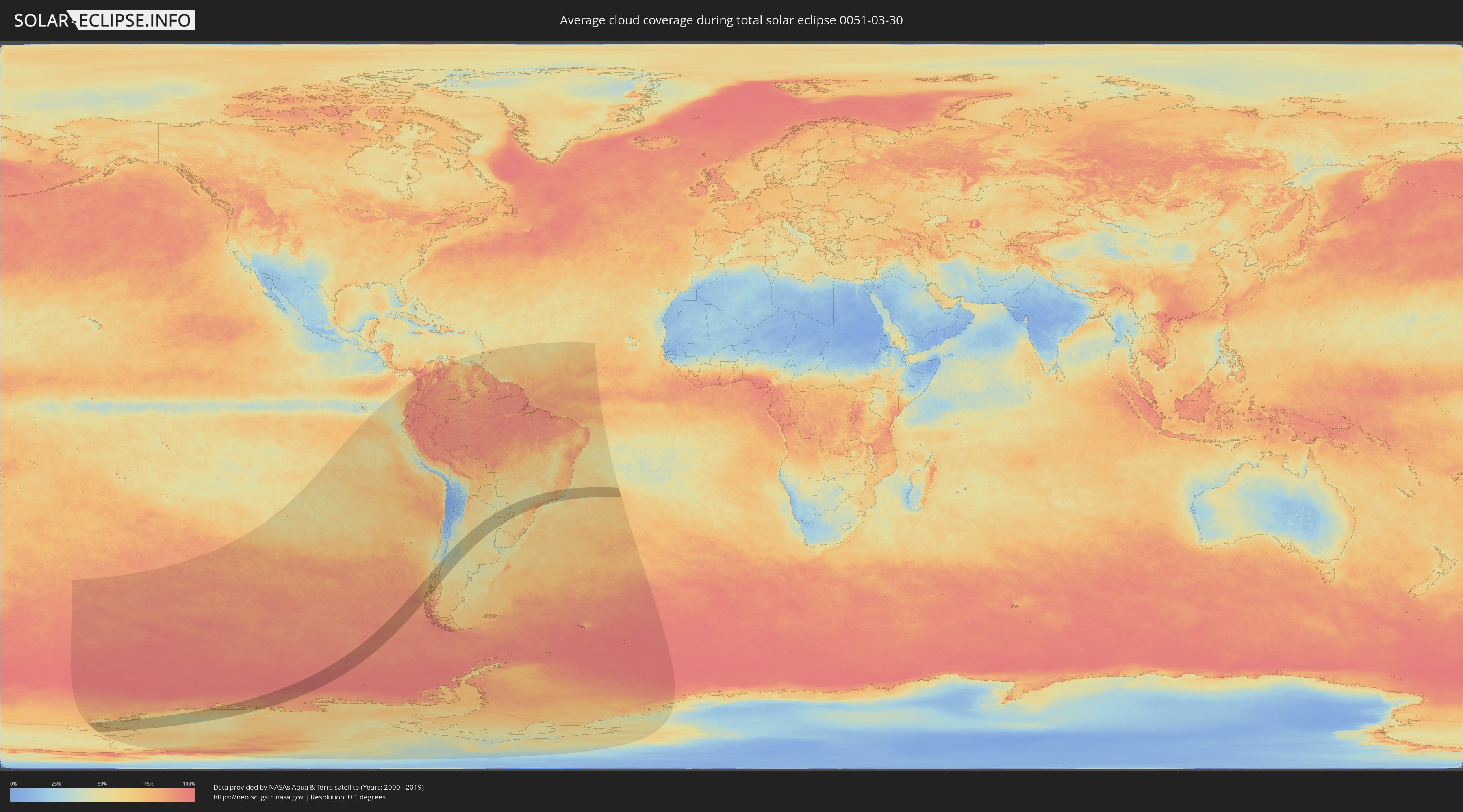
Wie wird das Wetter während der totalen Sonnenfinsternis am 30.03.0051?
Wo ist der beste Ort, um die totale Sonnenfinsternis vom 30.03.0051 zu beobachten?
Die folgenden Karten zeigen die durchschnittliche Bewölkung für den Tag, an dem die totale Sonnenfinsternis
stattfindet. Mit Hilfe der Karten lässt sich der Ort entlang des Finsternispfades eingrenzen,
der die besten Aussichen auf einen klaren wolkenfreien Himmel bietet.
Trotzdem muss man immer lokale Gegenenheiten beachten und sollte sich genau über das Wetter an seinem
gewählten Beobachtungsort informieren.
Die Daten stammen von den beiden NASA-Satelliten
AQUA und TERRA
und wurden über einen Zeitraum von 19 Jahren (2000 - 2019) gemittelt.
Detaillierte Länderkarten
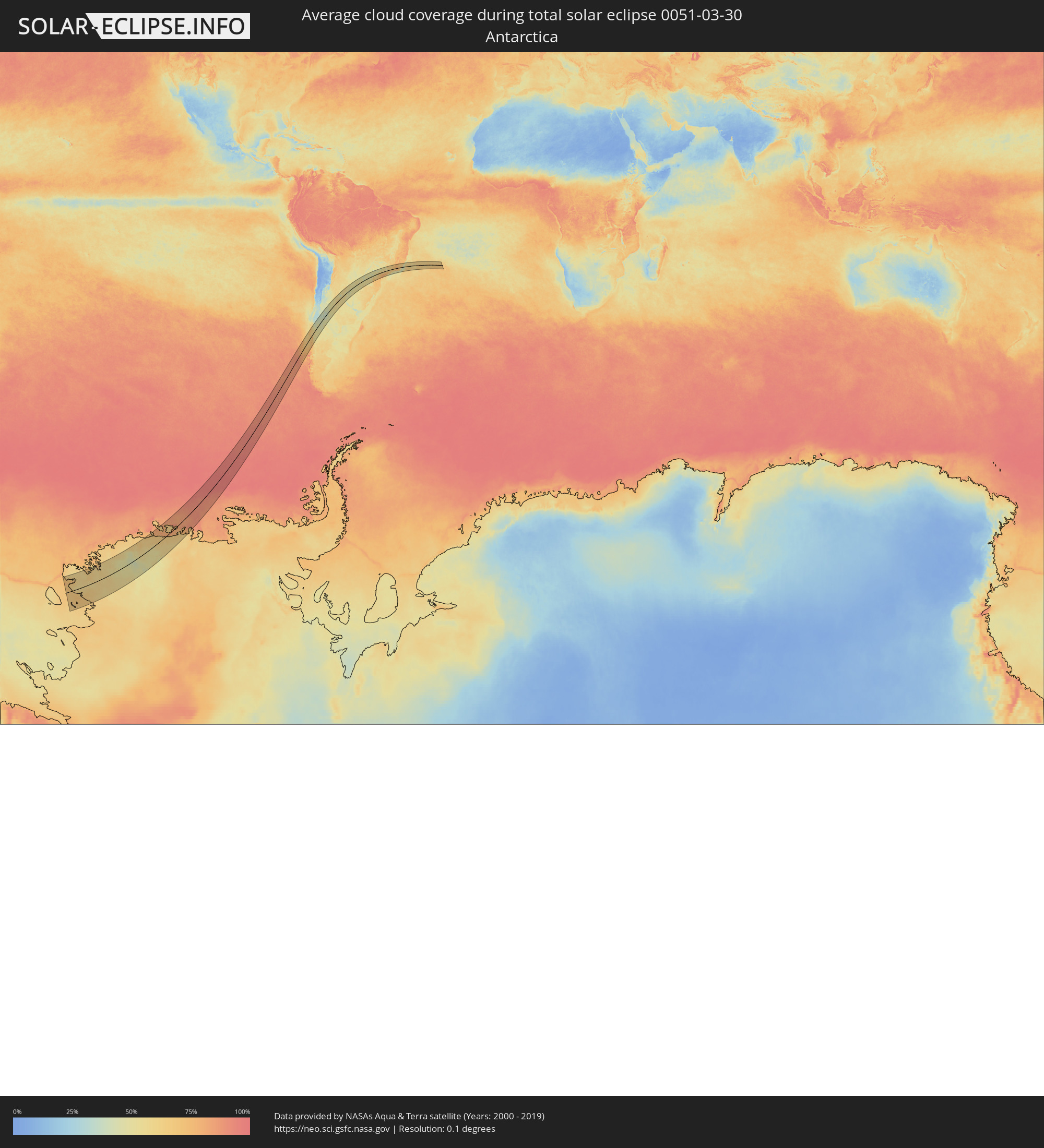 Antarktika
 Chile
Chile
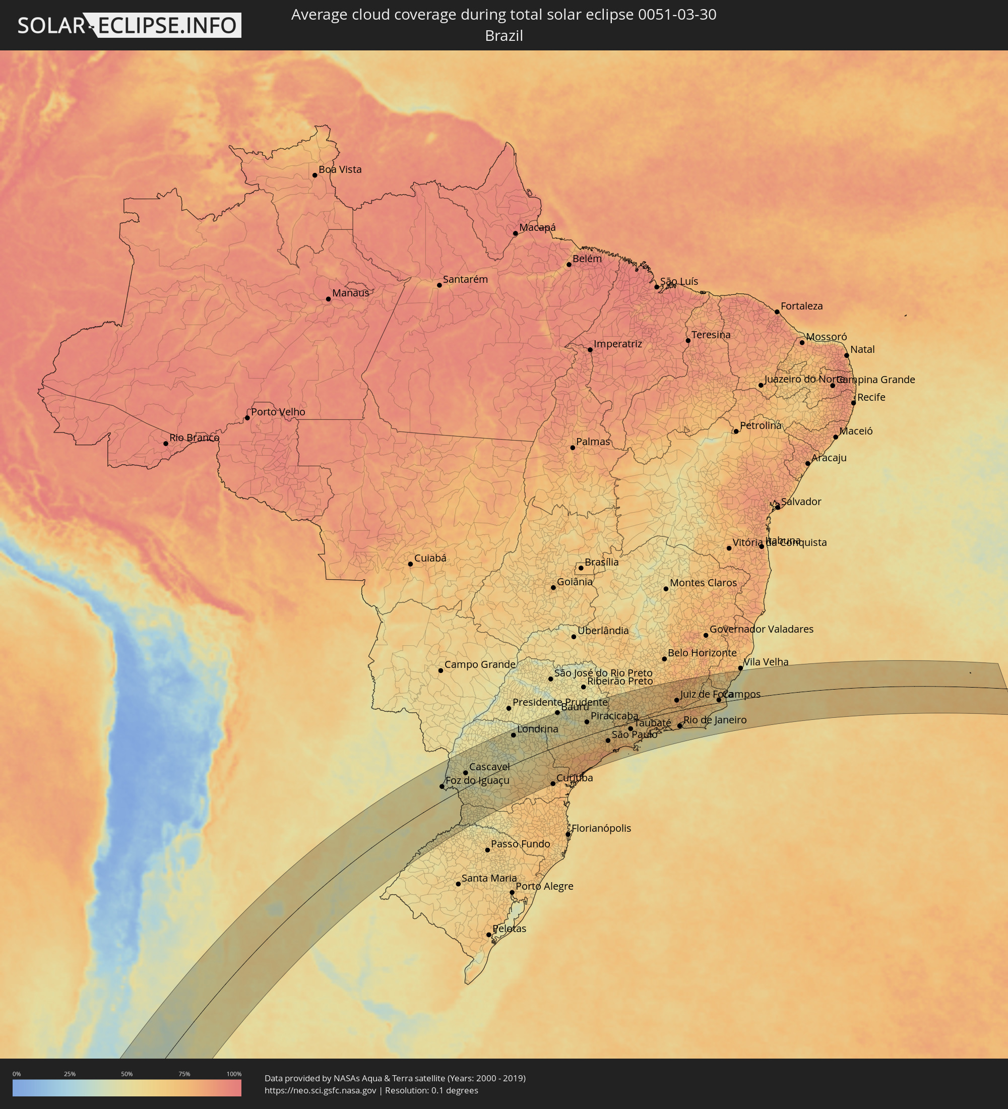 Brasilien
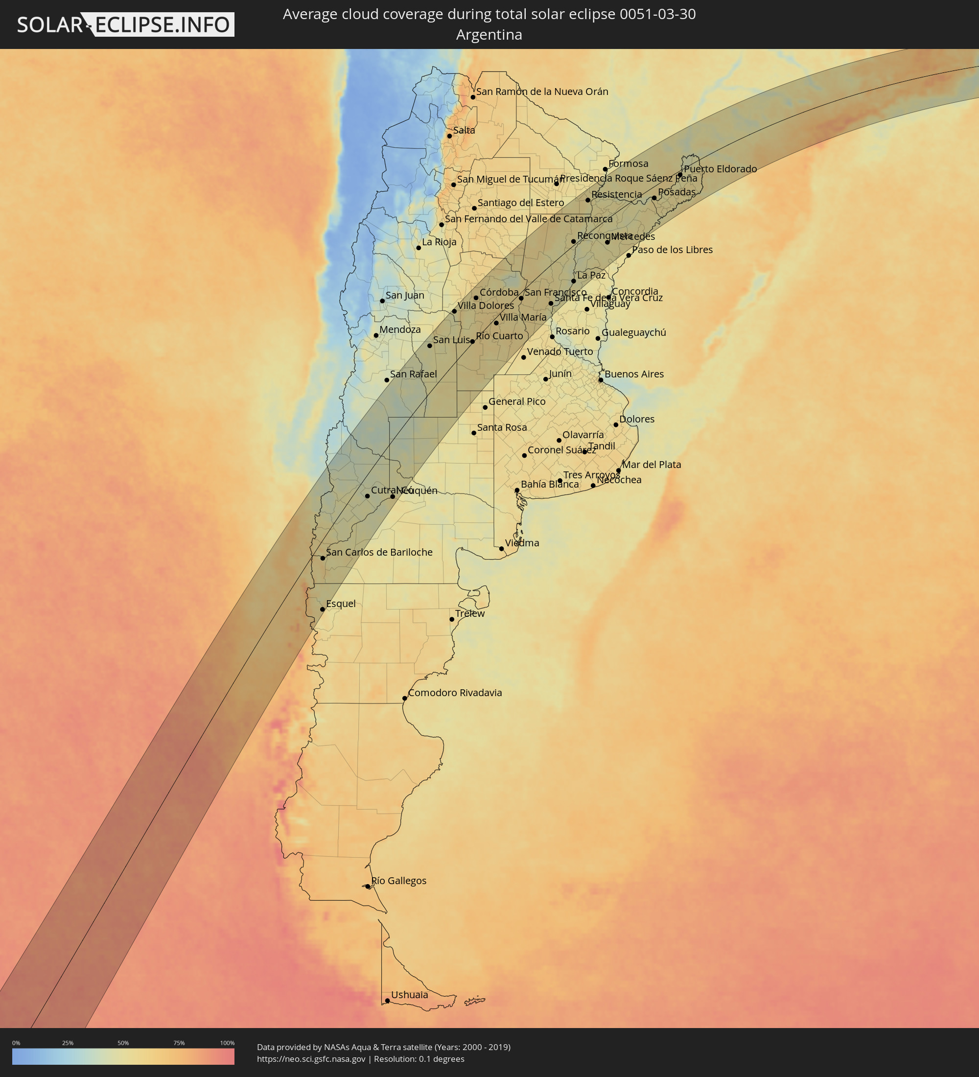 Argentinien
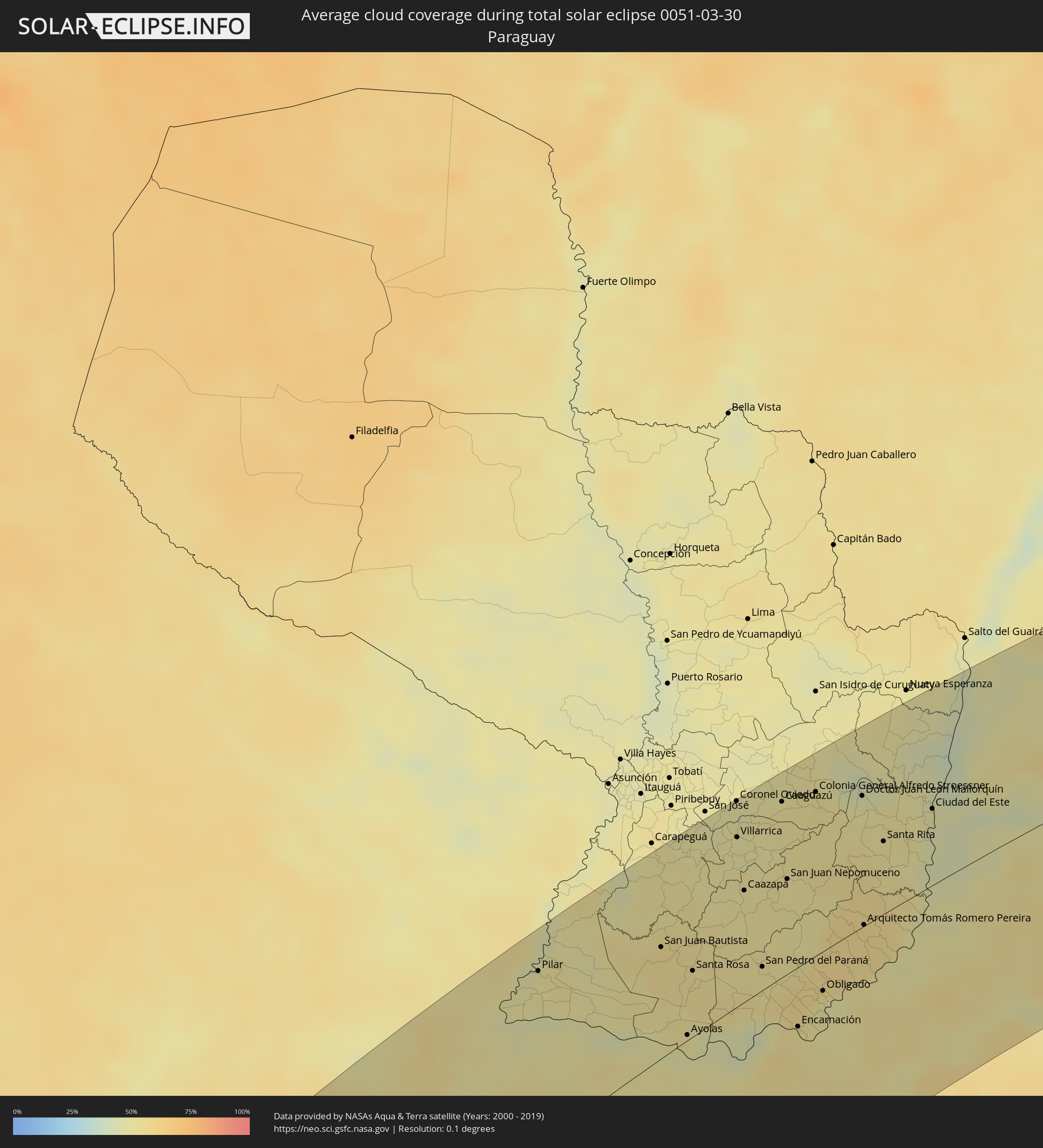 Paraguay
Orte im Finsternispfad
Die nachfolgene Tabelle zeigt Städte und Orte mit mehr als 5.000 Einwohnern, die sich im Finsternispfad befinden. Städte mit mehr als 100.000 Einwohnern sind dick gekennzeichnet. Mit einem Klick auf den Ort öffnet sich eine Detailkarte die die Lage des jeweiligen Ortes zusammen mit dem Verlauf der zentralen Finsternis präsentiert.
| Ort | Typ | Dauer der Verfinsterung | Ortszeit bei maximaler Verfinsterung | Entfernung zur Zentrallinie | Ø Bewölkung |
 Ancud, Los Lagos
|
total | - | 13:53:51 UTC-04:42 | 89 km | 60% |
|
Chonchi, Los Lagos
|
total | - | 13:52:42 UTC-04:42 | 42 km | 62% |
|
Castro, Los Lagos
|
total | - | 13:52:56 UTC-04:42 | 50 km | 60% |
|
Puerto Quellón, Los Lagos
|
total | - | 13:52:06 UTC-04:42 | 1 km | 65% |
|
Purranque, Los Lagos
|
total | - | 13:56:16 UTC-04:42 | 102 km | 69% |
|
Osorno, Los Lagos
|
total | - | 13:56:52 UTC-04:42 | 121 km | 67% |
|
Calbuco, Los Lagos
|
total | - | 13:54:53 UTC-04:42 | 48 km | 68% |
|
La Unión, Los Ríos
|
total | - | 13:57:24 UTC-04:42 | 135 km | 65% |
|
Frutillar, Los Lagos
|
total | - | 13:56:04 UTC-04:42 | 81 km | 65% |
|
Puerto Varas, Los Lagos
|
total | - | 13:55:49 UTC-04:42 | 65 km | 69% |
|
Río Bueno, Los Ríos
|
total | - | 13:57:29 UTC-04:42 | 123 km | 69% |
|
Puerto Montt, Los Lagos
|
total | - | 13:55:37 UTC-04:42 | 53 km | 68% |
|
Panguipulli, Araucanía
|
total | - | 13:59:28 UTC-04:42 | 123 km | 59% |
|
Villarrica, Araucanía
|
total | - | 14:00:13 UTC-04:42 | 138 km | 57% |
|
Pucón, Araucanía
|
total | - | 14:00:35 UTC-04:42 | 119 km | 55% |
 San Martín de los Andes, Neuquén Province
|
total | - | 14:25:49 UTC-04:16 | 21 km | 52% |
|
Esquel, Chubut Province
|
total | - | 14:21:17 UTC-04:16 | 146 km | 59% |
|
San Carlos de Bariloche, Río Negro Province
|
total | - | 14:24:13 UTC-04:16 | 42 km | 51% |
|
Zapala, Neuquén Province
|
total | - | 14:29:40 UTC-04:16 | 8 km | 48% |
|
Cutral-Có, Neuquén Province
|
total | - | 14:30:39 UTC-04:16 | 53 km | 46% |
|
Plottier, Neuquén Province
|
total | - | 14:31:51 UTC-04:16 | 126 km | 53% |
|
Neuquén, Neuquén Province
|
total | - | 14:32:06 UTC-04:16 | 137 km | 53% |
|
Allen, Río Negro Province
|
total | - | 14:32:21 UTC-04:16 | 156 km | 52% |
|
San Luis, San Luis Province
|
total | - | 14:44:35 UTC-04:16 | 126 km | 49% |
|
Villa Mercedes, San Luis Province
|
total | - | 14:44:59 UTC-04:16 | 37 km | 50% |
|
Villa Dolores, Cordoba Province
|
total | - | 14:48:34 UTC-04:16 | 148 km | 48% |
|
Villa Carlos Paz, Cordoba Province
|
total | - | 14:50:24 UTC-04:16 | 141 km | 51% |
|
Alta Gracia, Cordoba Province
|
total | - | 14:50:04 UTC-04:16 | 118 km | 52% |
|
Río Cuarto, Cordoba Province
|
total | - | 14:47:23 UTC-04:16 | 0 km | 58% |
|
La Calera, Cordoba Province
|
total | - | 14:50:45 UTC-04:16 | 136 km | 57% |
|
Córdoba, Cordoba Province
|
total | - | 14:50:49 UTC-04:16 | 120 km | 58% |
|
Río Tercero, Cordoba Province
|
total | - | 14:49:28 UTC-04:16 | 57 km | 56% |
|
Jesús María, Cordoba Province
|
total | - | 14:51:44 UTC-04:16 | 148 km | 57% |
|
Laboulaye, Cordoba Province
|
total | - | 14:46:41 UTC-04:16 | 140 km | 55% |
|
Villa María, Cordoba Province
|
total | - | 14:50:05 UTC-04:16 | 21 km | 57% |
|
Arroyito, Cordoba Province
|
total | - | 14:52:11 UTC-04:16 | 43 km | 56% |
|
Bell Ville, Cordoba Province
|
total | - | 14:50:20 UTC-04:16 | 75 km | 58% |
|
Marcos Juárez, Cordoba Province
|
total | - | 14:50:54 UTC-04:16 | 120 km | 56% |
|
San Francisco, Cordoba Province
|
total | - | 14:53:19 UTC-04:16 | 22 km | 58% |
|
Rafaela, Santa Fe Province
|
total | - | 14:54:21 UTC-04:16 | 47 km | 55% |
|
Esperanza, Santa Fe Province
|
total | - | 14:54:38 UTC-04:16 | 100 km | 56% |
|
Santa Fe de la Vera Cruz, Santa Fe Province
|
total | - | 14:54:33 UTC-04:16 | 130 km | 52% |
|
San Justo, Santa Fe Province
|
total | - | 14:56:16 UTC-04:16 | 68 km | 54% |
|
Paraná, Entre Ríos Province
|
total | - | 14:54:34 UTC-04:16 | 149 km | 50% |
|
Vera, Santa Fe Province
|
total | - | 14:59:12 UTC-04:16 | 19 km | 48% |
|
Reconquista, Santa Fe Province
|
total | - | 15:00:25 UTC-04:16 | 10 km | 50% |
|
La Paz, Entre Ríos Province
|
total | - | 14:57:25 UTC-04:16 | 125 km | 47% |
|
Esquina, Corrientes Province
|
total | - | 14:58:56 UTC-04:16 | 71 km | 45% |
|
Villa Ocampo, Santa Fe Province
|
total | - | 15:02:00 UTC-04:16 | 50 km | 52% |
|
Goya, Corrientes Province
|
total | - | 15:00:52 UTC-04:16 | 13 km | 50% |
|
Resistencia, Chaco Province
|
total | - | 15:04:20 UTC-04:16 | 118 km | 50% |
|
San Lorenzo, Corrientes Province
|
total | - | 15:03:18 UTC-04:16 | 46 km | 52% |
 Pilar, Ñeembucú
|
total | - | 15:32:19 UTC-03:50 | 131 km | 50% |
|
Mercedes, Corrientes Province
|
total | - | 15:02:05 UTC-04:16 | 88 km | 48% |
|
Curuzú Cuatiá, Corrientes Province
|
total | - | 15:00:58 UTC-04:16 | 143 km | 50% |
|
Quiindy, Paraguarí
|
total | - | 15:35:04 UTC-03:50 | 157 km | 52% |
|
San Juan Bautista, Misiones
|
total | - | 15:33:54 UTC-03:50 | 85 km | 55% |
|
Ayolas, Misiones
|
total | - | 15:32:48 UTC-03:50 | 4 km | 48% |
|
Santa Rosa, Misiones
|
total | - | 15:33:50 UTC-03:50 | 51 km | 54% |
|
Coronel Oviedo, Caaguazú
|
total | - | 15:36:53 UTC-03:50 | 162 km | 48% |
|
Villarrica, Guairá
|
total | - | 15:36:19 UTC-03:50 | 133 km | 48% |
|
Caazapá, Caazapá
|
total | - | 15:35:34 UTC-03:50 | 87 km | 50% |
|
San Pedro del Paraná, Itapúa
|
total | - | 15:34:34 UTC-03:50 | 18 km | 51% |
|
Santo Tomé, Corrientes Province
|
total | - | 15:05:25 UTC-04:16 | 149 km | 51% |
|
Gobernador Ingeniero Valentín Virasoro, Corrientes Province
|
total | - | 15:06:21 UTC-04:16 | 104 km | 51% |
|
Caaguazú, Caaguazú
|
total | - | 15:37:18 UTC-03:50 | 139 km | 53% |
|
San Juan Nepomuceno, Caazapá
|
total | - | 15:36:09 UTC-03:50 | 75 km | 51% |
|
Repatriación, Caaguazú
|
total | - | 15:37:12 UTC-03:50 | 128 km | 53% |
|
Posadas, Misiones Province
|
total | - | 15:07:45 UTC-04:16 | 48 km | 54% |
|
Encarnación, Itapúa
|
total | - | 15:33:59 UTC-03:50 | 46 km | 53% |
|
Hohenau, Itapúa
|
total | - | 15:34:34 UTC-03:50 | 29 km | 56% |
|
Colonia General Alfredo Stroessner, Caaguazú
|
total | - | 15:37:46 UTC-03:50 | 131 km | 53% |
|
Obligado, Itapúa
|
total | - | 15:34:46 UTC-03:50 | 31 km | 51% |
|
Doctor Juan León Mallorquín, Alto Paraná
|
total | - | 15:38:08 UTC-03:50 | 105 km | 49% |
|
Arquitecto Tomás Romero Pereira, Itapúa
|
total | - | 15:36:10 UTC-03:50 | 1 km | 57% |
|
Jardín América, Misiones Province
|
total | - | 15:09:01 UTC-04:16 | 53 km | 54% |
|
Oberá, Misiones Province
|
total | - | 15:08:19 UTC-04:16 | 101 km | 54% |
|
Santa Rita, Alto Paraná
|
total | - | 15:37:37 UTC-03:50 | 59 km | 52% |
|
Aristóbulo del Valle, Misiones Province
|
total | - | 15:09:15 UTC-04:16 | 76 km | 54% |
|
Montecarlo, Misiones Province
|
total | - | 15:10:22 UTC-04:16 | 32 km | 48% |
|
Puerto Eldorado, Misiones Province
|
total | - | 15:36:51 UTC-03:50 | 20 km | 47% |
|
Presidente Franco, Alto Paraná
|
total | - | 15:38:31 UTC-03:50 | 60 km | 47% |
|
Ciudad del Este, Alto Paraná
|
total | - | 15:38:34 UTC-03:50 | 62 km | 47% |
 Foz do Iguaçu, Paraná
|
total | - | 16:22:43 UTC-03:06 | 57 km | 47% |
|
Puerto Iguazú, Misiones Province
|
total | - | 15:12:18 UTC-04:16 | 52 km | 45% |
|
El Soberbio, Misiones Province
|
total | - | 15:09:33 UTC-04:16 | 131 km | 51% |
|
San Vicente, Misiones Province
|
total | - | 15:10:52 UTC-04:16 | 69 km | 52% |
|
Toledo, Paraná
|
total | - | 16:25:01 UTC-03:06 | 98 km | 50% |
|
Cascavel, Paraná
|
total | - | 16:24:51 UTC-03:06 | 61 km | 55% |
|
Maringá, Paraná
|
total | - | 16:28:55 UTC-03:06 | 147 km | 55% |
|
Guarapuava, Paraná
|
total | - | 16:25:51 UTC-03:06 | 72 km | 57% |
|
Londrina, Paraná
|
total | - | 16:29:46 UTC-03:06 | 127 km | 48% |
|
Ponta Grossa, Paraná
|
total | - | 16:27:28 UTC-03:06 | 96 km | 60% |
|
Colombo, Paraná
|
total | - | 16:27:53 UTC-03:06 | 152 km | 69% |
|
Bauru, São Paulo
|
total | - | 16:33:09 UTC-03:06 | 152 km | 51% |
|
Jaú, São Paulo
|
total | - | 16:33:33 UTC-03:06 | 136 km | 46% |
|
Itapetininga, São Paulo
|
total | - | 16:31:43 UTC-03:06 | 17 km | 64% |
|
São Carlos, São Paulo
|
total | - | 16:34:31 UTC-03:06 | 144 km | 56% |
|
Piracicaba, São Paulo
|
total | - | 16:33:29 UTC-03:06 | 61 km | 59% |
|
Rio Claro, São Paulo
|
total | - | 16:34:05 UTC-03:06 | 92 km | 56% |
|
Sorocaba, São Paulo
|
total | - | 16:32:19 UTC-03:06 | 27 km | 64% |
|
Santa Bárbara d'Oeste, São Paulo
|
total | - | 16:33:37 UTC-03:06 | 51 km | 59% |
|
Limeira, São Paulo
|
total | - | 16:33:56 UTC-03:06 | 71 km | 56% |
|
Itu, São Paulo
|
total | - | 16:32:50 UTC-03:06 | 7 km | 60% |
|
Sumaré, São Paulo
|
total | - | 16:33:36 UTC-03:06 | 39 km | 61% |
|
Indaiatuba, São Paulo
|
total | - | 16:33:11 UTC-03:06 | 9 km | 62% |
|
Campinas, São Paulo
|
total | - | 16:33:36 UTC-03:06 | 24 km | 62% |
|
Mogi-Gaucu, São Paulo
|
total | - | 16:34:35 UTC-03:06 | 78 km | 49% |
|
Cotia, São Paulo
|
total | - | 16:32:31 UTC-03:06 | 55 km | 72% |
|
Jundiaí, São Paulo
|
total | - | 16:33:15 UTC-03:06 | 11 km | 63% |
|
Osasco, São Paulo
|
total | - | 16:32:44 UTC-03:06 | 51 km | 68% |
|
Francisco Morato, São Paulo
|
total | - | 16:33:11 UTC-03:06 | 26 km | 65% |
|
São Paulo, São Paulo
|
total | - | 16:32:49 UTC-03:06 | 57 km | 71% |
|
São Bernardo do Campo, São Paulo
|
total | - | 16:32:37 UTC-03:06 | 75 km | 70% |
|
Poços de Caldas, Minas Gerais
|
total | - | 16:35:49 UTC-03:06 | 128 km | 64% |
|
Bragança Paulista, São Paulo
|
total | - | 16:33:53 UTC-03:06 | 3 km | 59% |
|
Itaquaquecetuba, São Paulo
|
total | - | 16:33:07 UTC-03:06 | 59 km | 71% |
|
Santos, São Paulo
|
total | - | 16:32:19 UTC-03:06 | 110 km | 62% |
|
Mogi das Cruzes, São Paulo
|
total | - | 16:33:10 UTC-03:06 | 68 km | 71% |
|
Jacareí, São Paulo
|
total | - | 16:33:41 UTC-03:06 | 51 km | 66% |
|
São José dos Campos, São Paulo
|
total | - | 16:33:56 UTC-03:06 | 40 km | 65% |
|
Taubaté, São Paulo
|
total | - | 16:34:25 UTC-03:06 | 33 km | 64% |
|
Varginha, Minas Gerais
|
total | - | 16:36:56 UTC-03:06 | 122 km | 65% |
|
Angra dos Reis, Rio de Janeiro
|
total | - | 16:35:14 UTC-03:06 | 63 km | 60% |
|
Volta Redonda, Rio de Janeiro
|
total | - | 16:36:09 UTC-03:06 | 16 km | 69% |
|
Barbacena, Minas Gerais
|
total | - | 16:38:27 UTC-03:06 | 117 km | 75% |
|
Nova Iguaçu, Rio de Janeiro
|
total | - | 16:36:09 UTC-03:06 | 57 km | 73% |
|
Juiz de Fora, Minas Gerais
|
total | - | 16:37:49 UTC-03:06 | 49 km | 78% |
|
Rio de Janeiro, Rio de Janeiro
|
total | - | 16:36:03 UTC-03:06 | 78 km | 57% |
|
Petrópolis, Rio de Janeiro
|
total | - | 16:36:43 UTC-03:06 | 35 km | 74% |
|
Teresópolis, Rio de Janeiro
|
total | - | 16:36:59 UTC-03:06 | 30 km | 79% |
|
Itaboraí, Rio de Janeiro
|
total | - | 16:36:31 UTC-03:06 | 68 km | 66% |
|
Nova Friburgo, Rio de Janeiro
|
total | - | 16:37:26 UTC-03:06 | 24 km | 80% |
|
Macaé, Rio de Janeiro
|
total | - | 16:37:42 UTC-03:06 | 49 km | 49% |
|
Campos, Rio de Janeiro
|
total | - | 16:38:55 UTC-03:06 | 11 km | 67% |
|
Cachoeiro de Itapemirim, Espírito Santo
|
total | - | 16:40:26 UTC-03:06 | 106 km | 61% |