Totale Sonnenfinsternis vom 21.12.0279
| Wochentag: | Sonntag |
| Maximale Dauer der Verfinsterung: | 03m21s |
| Maximale Breite des Finsternispfades: | 142 km |
| Saroszyklus: | 75 |
| Bedeckungsgrad: | 100% |
| Magnitude: | 1.0406 |
| Gamma: | -0.2811 |
Wo kann man die Sonnenfinsternis vom 21.12.0279 sehen?
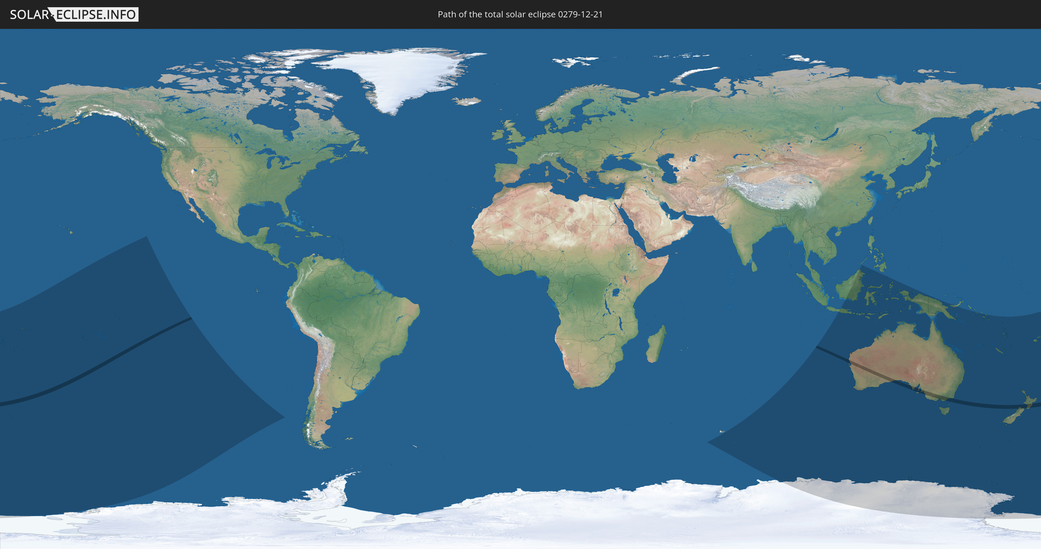
Die Sonnenfinsternis am 21.12.0279 kann man in 27 Ländern als partielle Sonnenfinsternis beobachten.
Der Finsternispfad verläuft durch 3 Länder. Nur in diesen Ländern ist sie als totale Sonnenfinsternis zu sehen.
In den folgenden Ländern ist die Sonnenfinsternis total zu sehen
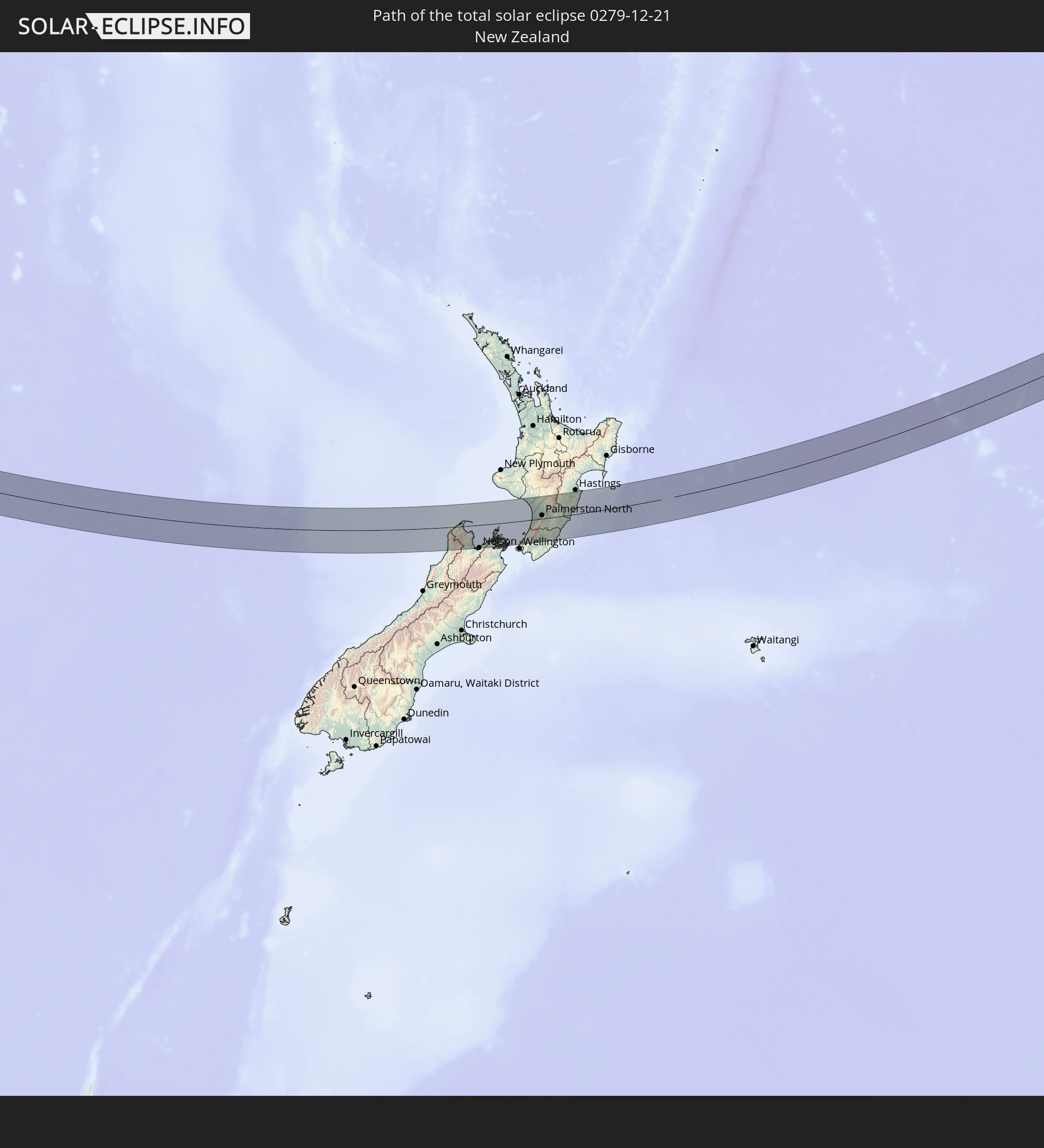 Neuseeland
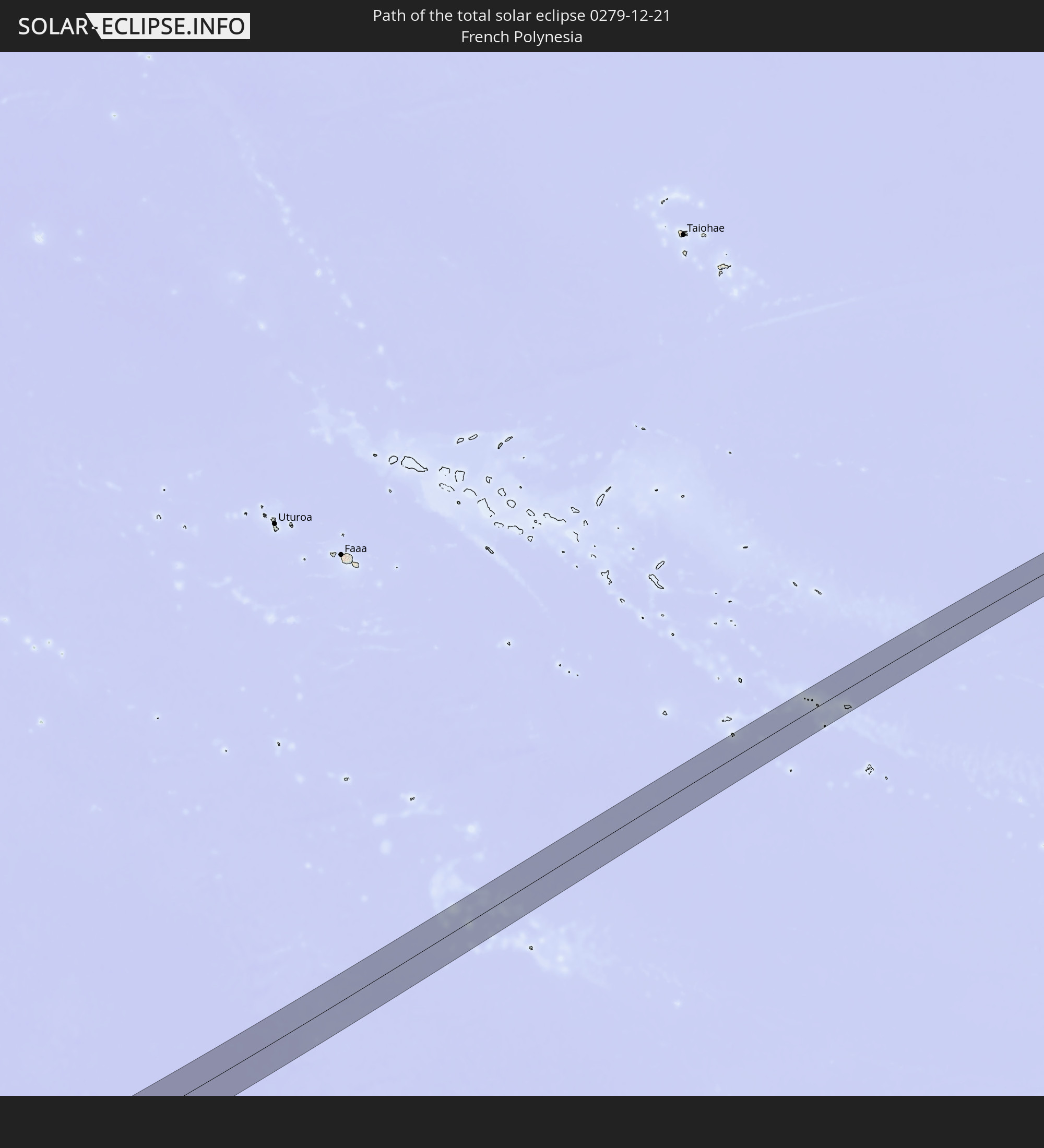 Französisch-Polynesien
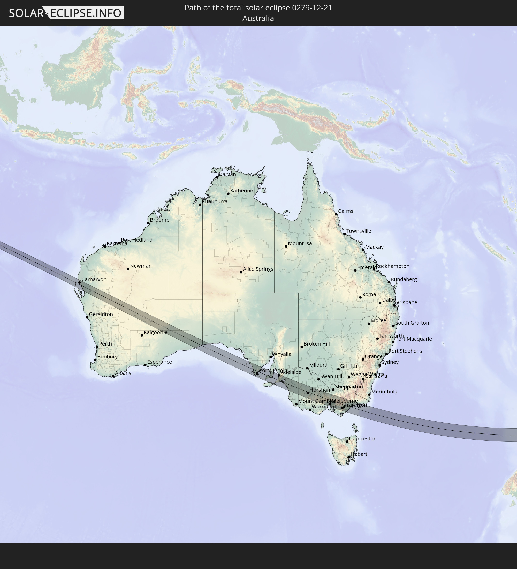 Australien
In den folgenden Ländern ist die Sonnenfinsternis partiell zu sehen
 Fidschi
 Antarktika
 Neuseeland
 United States Minor Outlying Islands
 Wallis und Futuna
 Tonga
Tonga
 Kiribati
 Samoa
Samoa
 Tokelau
 Amerikanisch-Samoa
 Niue
Niue
 Cookinseln
 Französisch-Polynesien
 Pitcairninseln
 Chile
Chile
 Heard und McDonaldinseln
 Indonesien
 Malaysia
 Australien
 Philippinen
 Osttimor
 Papua-Neuguinea
 Salomonen
 Neukaledonien
 Vanuatu
 Norfolkinsel
 Tuvalu
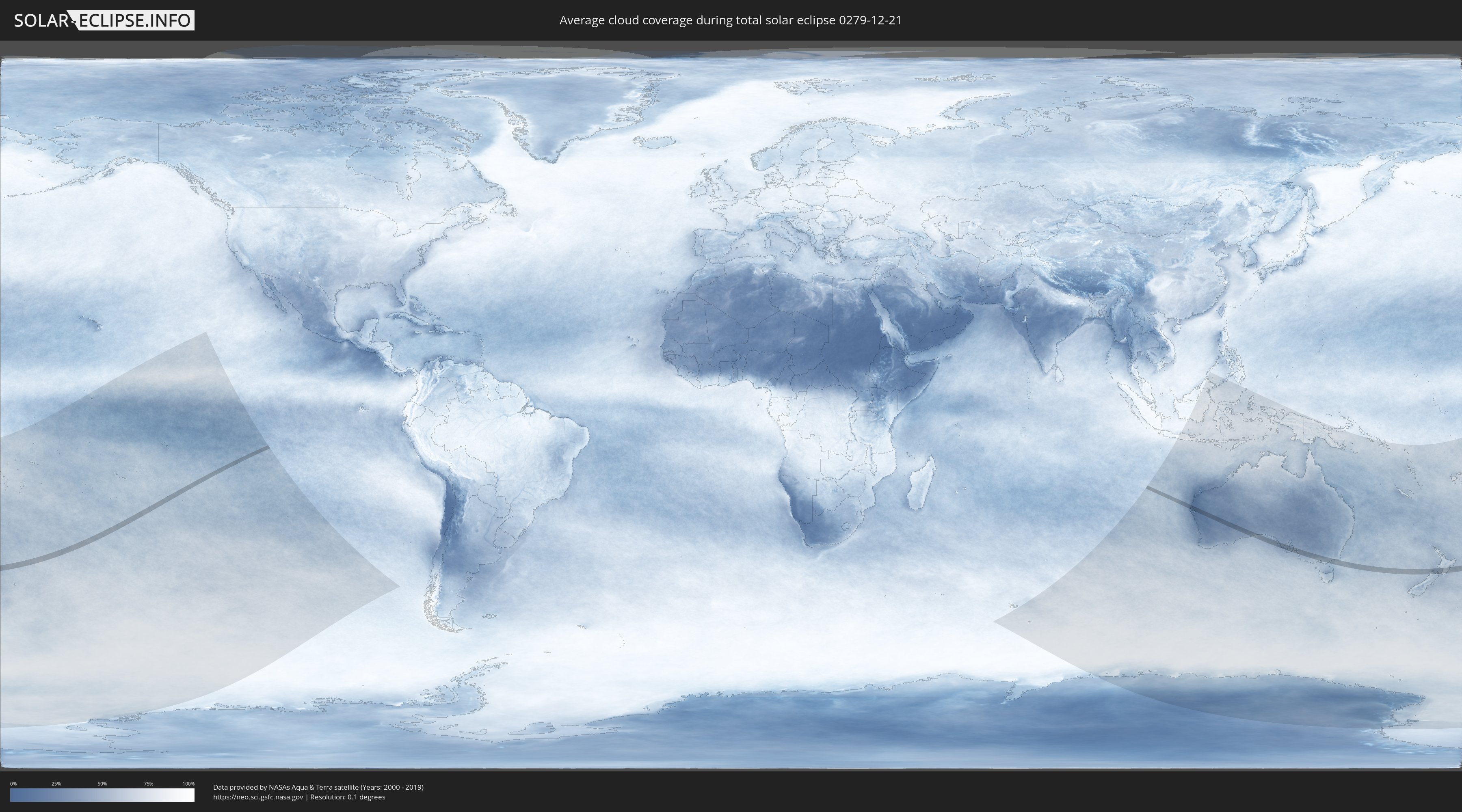
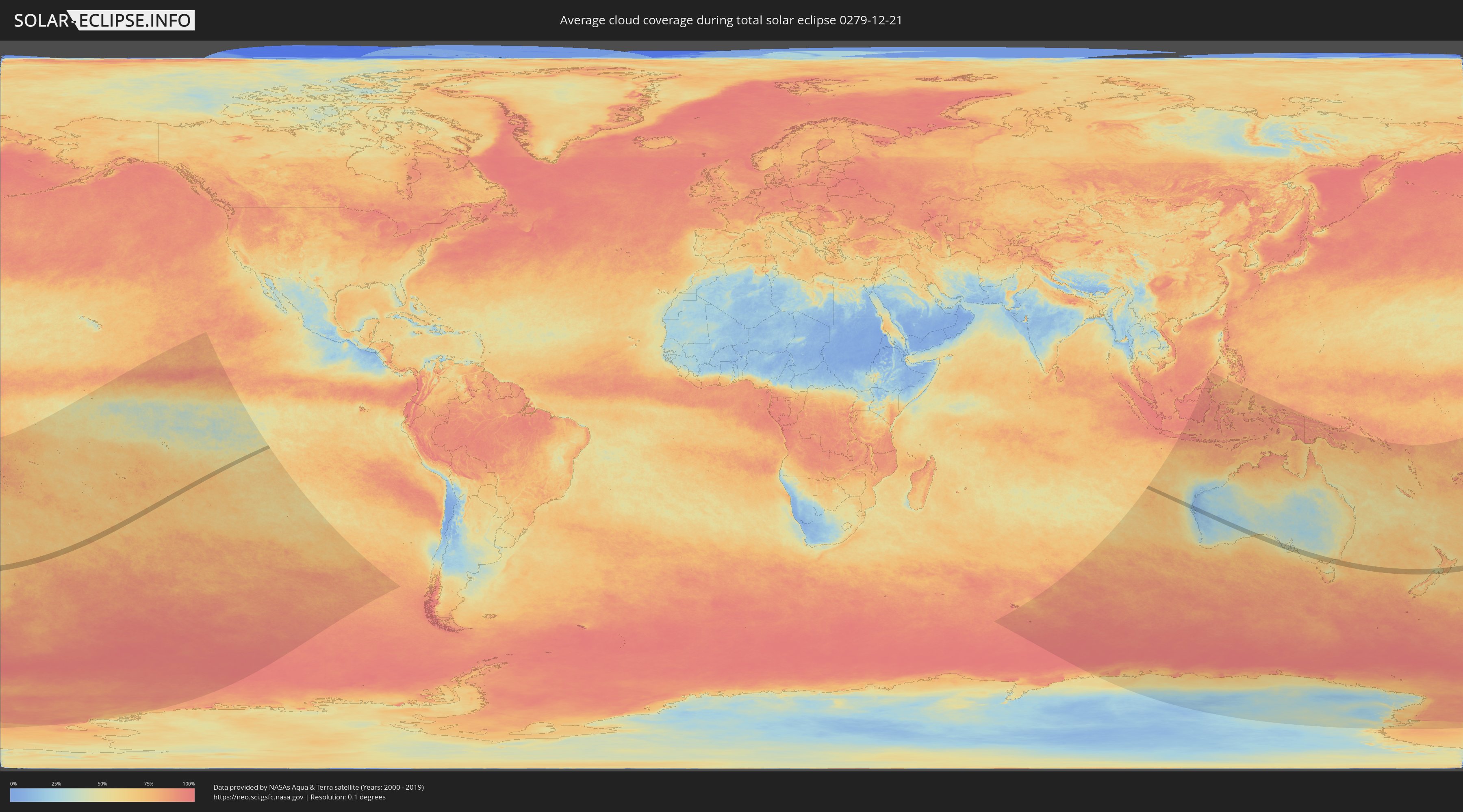
Wie wird das Wetter während der totalen Sonnenfinsternis am 21.12.0279?
Wo ist der beste Ort, um die totale Sonnenfinsternis vom 21.12.0279 zu beobachten?
Die folgenden Karten zeigen die durchschnittliche Bewölkung für den Tag, an dem die totale Sonnenfinsternis
stattfindet. Mit Hilfe der Karten lässt sich der Ort entlang des Finsternispfades eingrenzen,
der die besten Aussichen auf einen klaren wolkenfreien Himmel bietet.
Trotzdem muss man immer lokale Gegenenheiten beachten und sollte sich genau über das Wetter an seinem
gewählten Beobachtungsort informieren.
Die Daten stammen von den beiden NASA-Satelliten
AQUA und TERRA
und wurden über einen Zeitraum von 19 Jahren (2000 - 2019) gemittelt.
Detaillierte Länderkarten
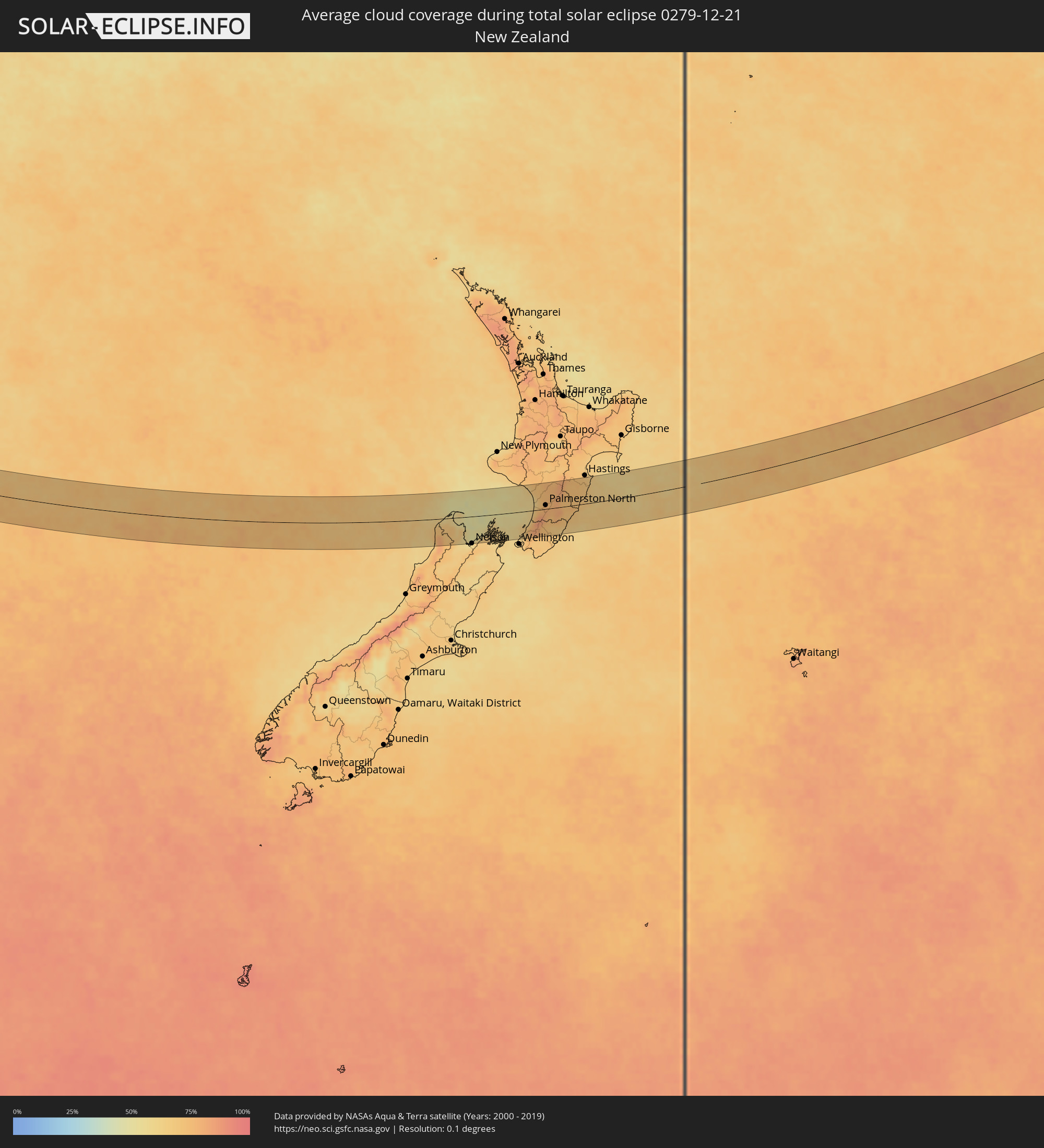 Neuseeland
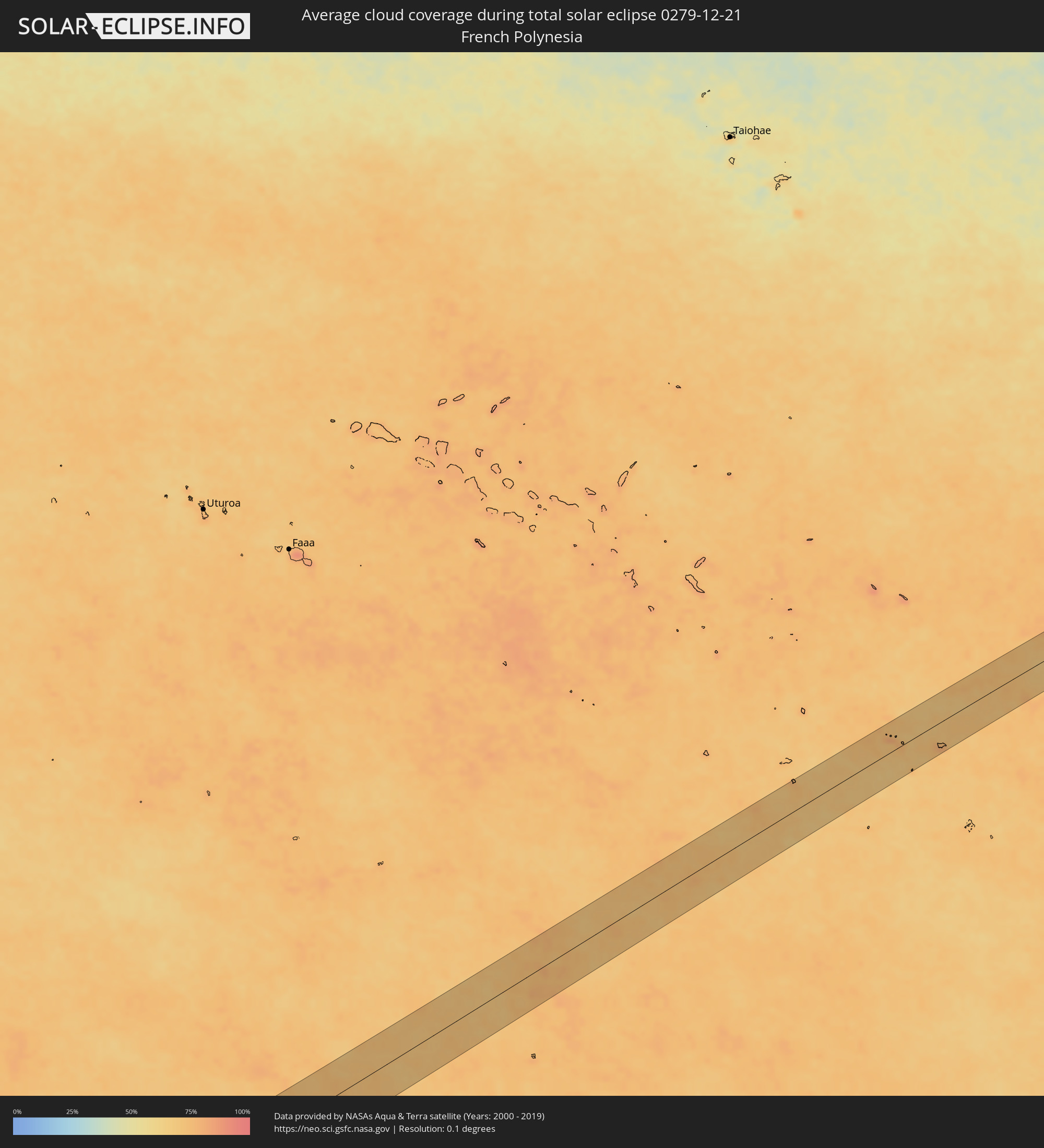 Französisch-Polynesien
 Australien
Orte im Finsternispfad
Die nachfolgene Tabelle zeigt Städte und Orte mit mehr als 5.000 Einwohnern, die sich im Finsternispfad befinden. Städte mit mehr als 100.000 Einwohnern sind dick gekennzeichnet. Mit einem Klick auf den Ort öffnet sich eine Detailkarte die die Lage des jeweiligen Ortes zusammen mit dem Verlauf der zentralen Finsternis präsentiert.
| Ort | Typ | Dauer der Verfinsterung | Ortszeit bei maximaler Verfinsterung | Entfernung zur Zentrallinie | Ø Bewölkung |
|
Carnarvon, Western Australia
|
total | - | 06:38:42 UTC+08:00 | 19 km | 15% |
|
Port Lincoln, South Australia
|
total | - | 08:28:59 UTC+09:30 | 26 km | 50% |
|
Aldinga, South Australia
|
total | - | 08:32:07 UTC+09:30 | 11 km | 46% |
|
Morphett Vale, South Australia
|
total | - | 08:31:58 UTC+09:30 | 27 km | 43% |
|
North Adelaide, South Australia
|
total | - | 08:31:47 UTC+09:30 | 53 km | 42% |
|
Adelaide, South Australia
|
total | - | 08:31:49 UTC+09:30 | 51 km | 42% |
|
Victor Harbor, South Australia
|
total | - | 08:32:34 UTC+09:30 | 12 km | 52% |
|
Ingle Farm, South Australia
|
total | - | 08:31:44 UTC+09:30 | 62 km | 41% |
|
Campbelltown, South Australia
|
total | - | 08:31:50 UTC+09:30 | 58 km | 44% |
|
Paradise, South Australia
|
total | - | 08:31:49 UTC+09:30 | 59 km | 44% |
|
Mount Barker, South Australia
|
total | - | 08:32:15 UTC+09:30 | 46 km | 46% |
|
Murray Bridge, South Australia
|
total | - | 08:32:44 UTC+09:30 | 55 km | 43% |
|
Horsham, Victoria
|
total | - | 09:07:47 UTC+10:00 | 13 km | 48% |
|
Ararat, Victoria
|
total | - | 09:09:18 UTC+10:00 | 50 km | 57% |
|
Maryborough, Victoria
|
total | - | 09:10:00 UTC+10:00 | 0 km | 51% |
|
Sebastopol, Victoria
|
total | - | 09:10:44 UTC+10:00 | 53 km | 60% |
|
Ballarat, Victoria
|
total | - | 09:10:44 UTC+10:00 | 51 km | 60% |
|
Castlemaine, Victoria
|
total | - | 09:10:37 UTC+10:00 | 12 km | 54% |
|
Golden Square, Victoria
|
total | - | 09:10:20 UTC+10:00 | 44 km | 51% |
|
Bendigo, Victoria
|
total | - | 09:10:21 UTC+10:00 | 46 km | 51% |
|
Kennington, Victoria
|
total | - | 09:10:24 UTC+10:00 | 44 km | 51% |
|
Melton South, Victoria
|
total | - | 09:11:47 UTC+10:00 | 44 km | 65% |
|
Melton, Victoria
|
total | - | 09:11:46 UTC+10:00 | 42 km | 65% |
|
Kurunjang, Victoria
|
total | - | 09:11:47 UTC+10:00 | 41 km | 65% |
|
Hoppers Crossing, Victoria
|
total | - | 09:12:08 UTC+10:00 | 59 km | 67% |
|
Sunbury, Victoria
|
total | - | 09:11:50 UTC+10:00 | 26 km | 66% |
|
Derrimut, Victoria
|
total | - | 09:12:07 UTC+10:00 | 48 km | 64% |
|
Delahey, Victoria
|
total | - | 09:12:03 UTC+10:00 | 40 km | 66% |
|
Cairnlea, Victoria
|
total | - | 09:12:07 UTC+10:00 | 44 km | 64% |
|
Saint Albans, Victoria
|
total | - | 09:12:06 UTC+10:00 | 41 km | 66% |
|
Braybrook, Victoria
|
total | - | 09:12:13 UTC+10:00 | 45 km | 63% |
|
Maidstone, Victoria
|
total | - | 09:12:14 UTC+10:00 | 43 km | 63% |
|
Tullamarine, Victoria
|
total | - | 09:12:10 UTC+10:00 | 35 km | 63% |
|
Airport West, Victoria
|
total | - | 09:12:11 UTC+10:00 | 37 km | 63% |
|
Gladstone Park, Victoria
|
total | - | 09:12:09 UTC+10:00 | 33 km | 63% |
|
Oak Park, Victoria
|
total | - | 09:12:14 UTC+10:00 | 36 km | 63% |
|
Flemington, Victoria
|
total | - | 09:12:19 UTC+10:00 | 43 km | 63% |
|
Parkville, Victoria
|
total | - | 09:12:20 UTC+10:00 | 41 km | 61% |
|
Docklands, Victoria
|
total | - | 09:12:23 UTC+10:00 | 45 km | 61% |
|
Coburg North, Victoria
|
total | - | 09:12:18 UTC+10:00 | 35 km | 62% |
|
Melbourne, Victoria
|
total | - | 09:12:24 UTC+10:00 | 44 km | 61% |
|
South Melbourne, Victoria
|
total | - | 09:12:25 UTC+10:00 | 46 km | 61% |
|
Carlton North, Victoria
|
total | - | 09:12:22 UTC+10:00 | 41 km | 61% |
|
Brunswick East, Victoria
|
total | - | 09:12:21 UTC+10:00 | 40 km | 61% |
|
Fitzroy, Victoria
|
total | - | 09:12:24 UTC+10:00 | 42 km | 61% |
|
Windsor, Victoria
|
total | - | 09:12:28 UTC+10:00 | 48 km | 61% |
|
Clifton Hill, Victoria
|
total | - | 09:12:25 UTC+10:00 | 42 km | 61% |
|
Albert Park, Victoria
|
total | - | 09:12:28 UTC+10:00 | 45 km | 61% |
|
Black Rock, Victoria
|
total | - | 09:12:38 UTC+10:00 | 60 km | 61% |
|
Fairfield, Victoria
|
total | - | 09:12:25 UTC+10:00 | 39 km | 61% |
|
Epping, Victoria
|
total | - | 09:12:18 UTC+10:00 | 25 km | 62% |
|
Ormond, Victoria
|
total | - | 09:12:35 UTC+10:00 | 51 km | 61% |
|
Cheltenham, Victoria
|
total | - | 09:12:40 UTC+10:00 | 58 km | 61% |
|
Kew East, Victoria
|
total | - | 09:12:29 UTC+10:00 | 40 km | 59% |
|
Heidelberg Heights, Victoria
|
total | - | 09:12:26 UTC+10:00 | 34 km | 61% |
|
Rosanna, Victoria
|
total | - | 09:12:27 UTC+10:00 | 35 km | 59% |
|
Murrumbeena, Victoria
|
total | - | 09:12:37 UTC+10:00 | 50 km | 61% |
|
Hughesdale, Victoria
|
total | - | 09:12:38 UTC+10:00 | 50 km | 61% |
|
Ashburton, Victoria
|
total | - | 09:12:36 UTC+10:00 | 46 km | 61% |
|
Mordialloc, Victoria
|
total | - | 09:12:45 UTC+10:00 | 60 km | 62% |
|
Canterbury, Victoria
|
total | - | 09:12:33 UTC+10:00 | 42 km | 59% |
|
Oakleigh South, Victoria
|
total | - | 09:12:41 UTC+10:00 | 52 km | 61% |
|
Viewbank, Victoria
|
total | - | 09:12:28 UTC+10:00 | 33 km | 61% |
|
Mernda, Victoria
|
total | - | 09:12:19 UTC+10:00 | 18 km | 64% |
|
Aspendale, Victoria
|
total | - | 09:12:48 UTC+10:00 | 63 km | 62% |
|
Chelsea, Victoria
|
total | - | 09:12:51 UTC+10:00 | 65 km | 60% |
|
Clarinda, Victoria
|
total | - | 09:12:43 UTC+10:00 | 52 km | 61% |
|
Montmorency, Victoria
|
total | - | 09:12:29 UTC+10:00 | 30 km | 61% |
|
Aspendale Gardens, Victoria
|
total | - | 09:12:49 UTC+10:00 | 62 km | 62% |
|
Box Hill South, Victoria
|
total | - | 09:12:37 UTC+10:00 | 42 km | 59% |
|
Box Hill, Victoria
|
total | - | 09:12:36 UTC+10:00 | 40 km | 59% |
|
Doncaster East, Victoria
|
total | - | 09:12:36 UTC+10:00 | 36 km | 59% |
|
Eltham North, Victoria
|
total | - | 09:12:30 UTC+10:00 | 27 km | 63% |
|
Blackburn North, Victoria
|
total | - | 09:12:38 UTC+10:00 | 38 km | 63% |
|
Noble Park North, Victoria
|
total | - | 09:12:50 UTC+10:00 | 52 km | 63% |
|
Rowville, Victoria
|
total | - | 09:12:52 UTC+10:00 | 49 km | 63% |
|
Scoresby, Victoria
|
total | - | 09:12:50 UTC+10:00 | 46 km | 63% |
|
Doveton, Victoria
|
total | - | 09:12:57 UTC+10:00 | 55 km | 64% |
|
Knoxfield, Victoria
|
total | - | 09:12:50 UTC+10:00 | 44 km | 63% |
|
Lynbrook, Victoria
|
total | - | 09:13:02 UTC+10:00 | 61 km | 63% |
|
Cranbourne West, Victoria
|
total | - | 09:13:06 UTC+10:00 | 65 km | 63% |
|
Bayswater North, Victoria
|
total | - | 09:12:50 UTC+10:00 | 36 km | 67% |
|
Croydon North, Victoria
|
total | - | 09:12:47 UTC+10:00 | 31 km | 67% |
|
Lysterfield, Victoria
|
total | - | 09:12:57 UTC+10:00 | 47 km | 65% |
|
Chirnside Park, Victoria
|
total | - | 09:12:45 UTC+10:00 | 26 km | 65% |
|
Narre Warren North, Victoria
|
total | - | 09:13:02 UTC+10:00 | 52 km | 65% |
|
Upwey, Victoria
|
total | - | 09:12:58 UTC+10:00 | 43 km | 65% |
|
Berwick, Victoria
|
total | - | 09:13:08 UTC+10:00 | 56 km | 65% |
|
Montrose, Victoria
|
total | - | 09:12:53 UTC+10:00 | 33 km | 66% |
|
Lilydale, Victoria
|
total | - | 09:12:49 UTC+10:00 | 26 km | 66% |
|
Mount Evelyn, Victoria
|
total | - | 09:12:54 UTC+10:00 | 29 km | 66% |
|
Emerald, Victoria
|
total | - | 09:13:08 UTC+10:00 | 43 km | 65% |
|
Pakenham South, Victoria
|
total | - | 09:13:27 UTC+10:00 | 62 km | 63% |
|
Healesville, Victoria
|
total | - | 09:12:56 UTC+10:00 | 12 km | 67% |
|
Warragul, Victoria
|
total | - | 09:14:01 UTC+10:00 | 53 km | 65% |
|
Moe, Victoria
|
total | - | 09:14:28 UTC+10:00 | 46 km | 65% |
|
Traralgon, Victoria
|
total | - | 09:14:52 UTC+10:00 | 40 km | 65% |
|
Sale, Victoria
|
total | - | 09:15:29 UTC+10:00 | 17 km | 65% |
|
Bairnsdale, Victoria
|
total | - | 09:15:55 UTC+10:00 | 28 km | 65% |
|
Lakes Entrance, Victoria
|
total | - | 09:16:30 UTC+10:00 | 32 km | 59% |
|
Port Motueka, Tasman
|
total | - | 11:34:00 UTC+11:30 | 54 km | 56% |
|
Porirua, Wellington
|
total | - | 11:37:44 UTC+11:30 | 68 km | 67% |
|
Paraparaumu, Wellington
|
total | - | 11:38:08 UTC+11:30 | 46 km | 70% |
|
Wanganui, Manawatu-Wanganui
|
total | - | 11:38:26 UTC+11:30 | 63 km | 65% |
|
Upper Hutt, Wellington
|
total | - | 11:38:09 UTC+11:30 | 71 km | 75% |
|
Otaki, Wellington
|
total | - | 11:38:26 UTC+11:30 | 30 km | 78% |
|
Levin, Manawatu-Wanganui
|
total | - | 11:38:44 UTC+11:30 | 17 km | 78% |
|
Palmerston North, Manawatu-Wanganui
|
total | - | 11:39:30 UTC+11:30 | 10 km | 78% |
|
Masterton, Wellington
|
total | - | 11:39:26 UTC+11:30 | 57 km | 71% |