Totale Sonnenfinsternis vom 11.01.0316
| Wochentag: | Dienstag |
| Maximale Dauer der Verfinsterung: | 03m18s |
| Maximale Breite des Finsternispfades: | 142 km |
| Saroszyklus: | 75 |
| Bedeckungsgrad: | 100% |
| Magnitude: | 1.0406 |
| Gamma: | -0.2935 |
Wo kann man die Sonnenfinsternis vom 11.01.0316 sehen?
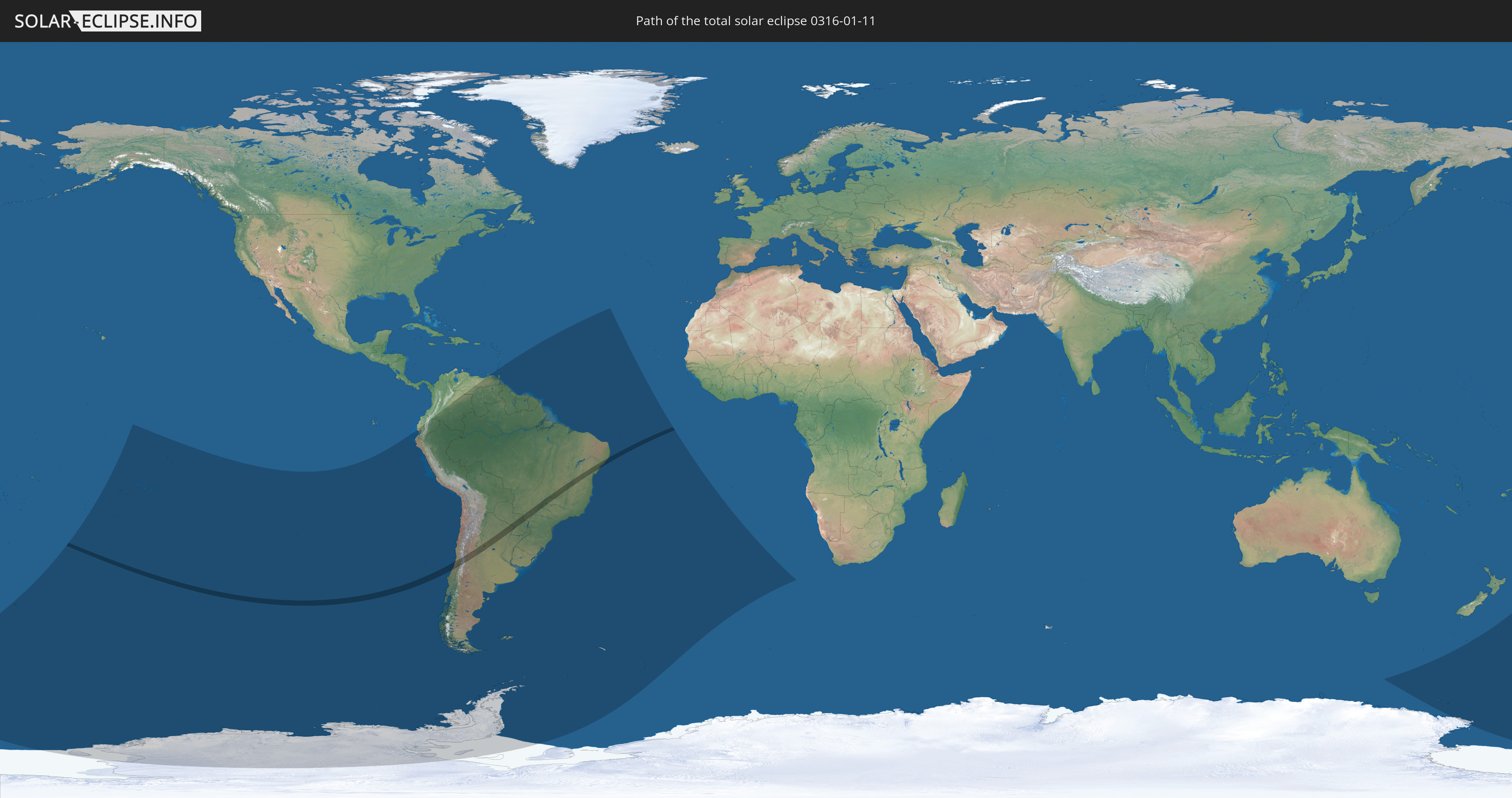
Die Sonnenfinsternis am 11.01.0316 kann man in 24 Ländern als partielle Sonnenfinsternis beobachten.
Der Finsternispfad verläuft durch 4 Länder. Nur in diesen Ländern ist sie als totale Sonnenfinsternis zu sehen.
In den folgenden Ländern ist die Sonnenfinsternis total zu sehen
 Chile
Chile
 Brasilien
 Argentinien
 Paraguay
In den folgenden Ländern ist die Sonnenfinsternis partiell zu sehen
 Antarktika
 Neuseeland
 Kiribati
 Cookinseln
 Französisch-Polynesien
 Pitcairninseln
 Chile
Chile
 Ecuador
 Kolumbien
 Peru
Peru
 Brasilien
 Argentinien
 Venezuela
 Bolivien
 Paraguay
 Trinidad und Tobago
 Falklandinseln
 Guyana
 Barbados
 Uruguay
 Suriname
 Französisch-Guayana
 Südgeorgien und die Südlichen Sandwichinseln
 St. Helena
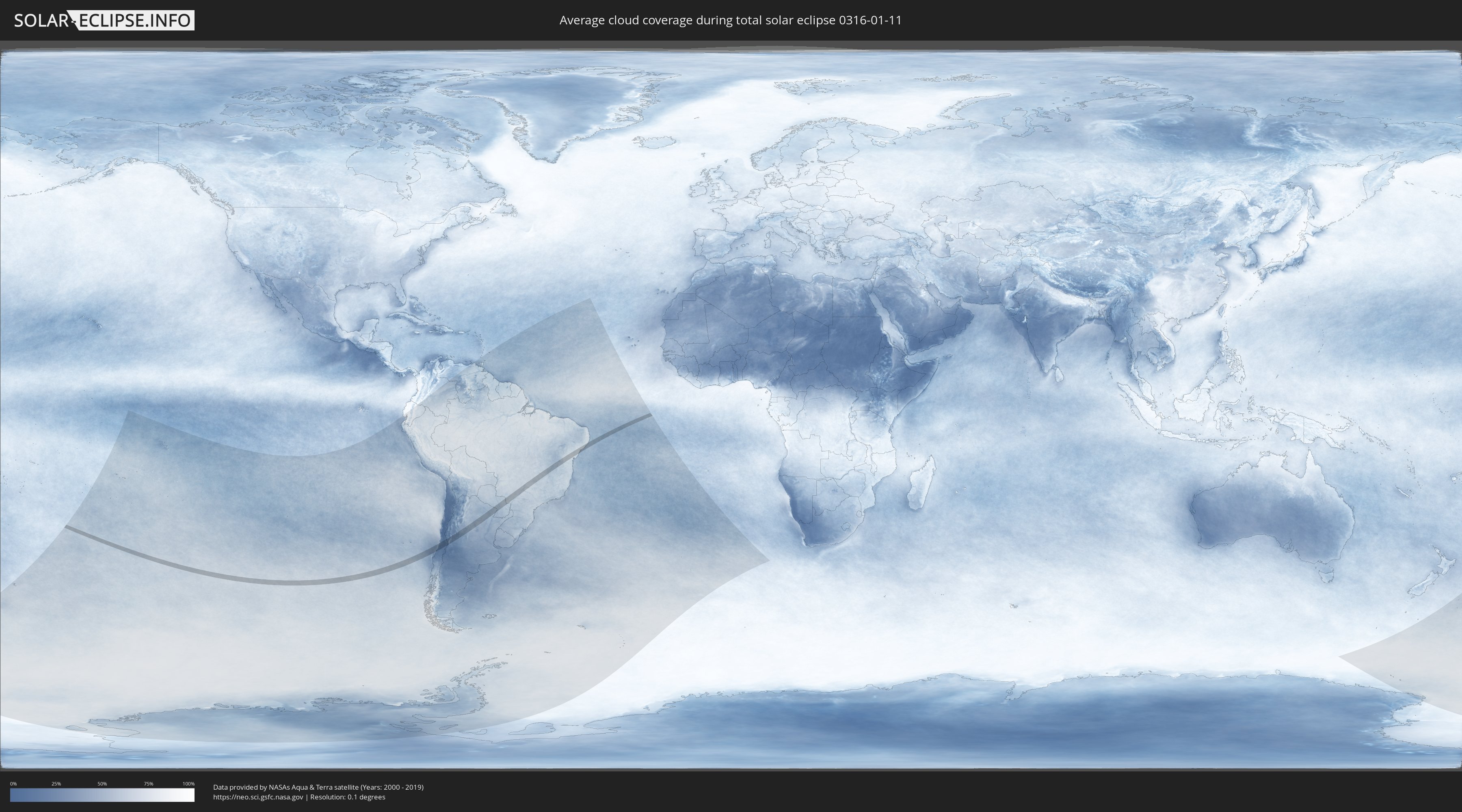
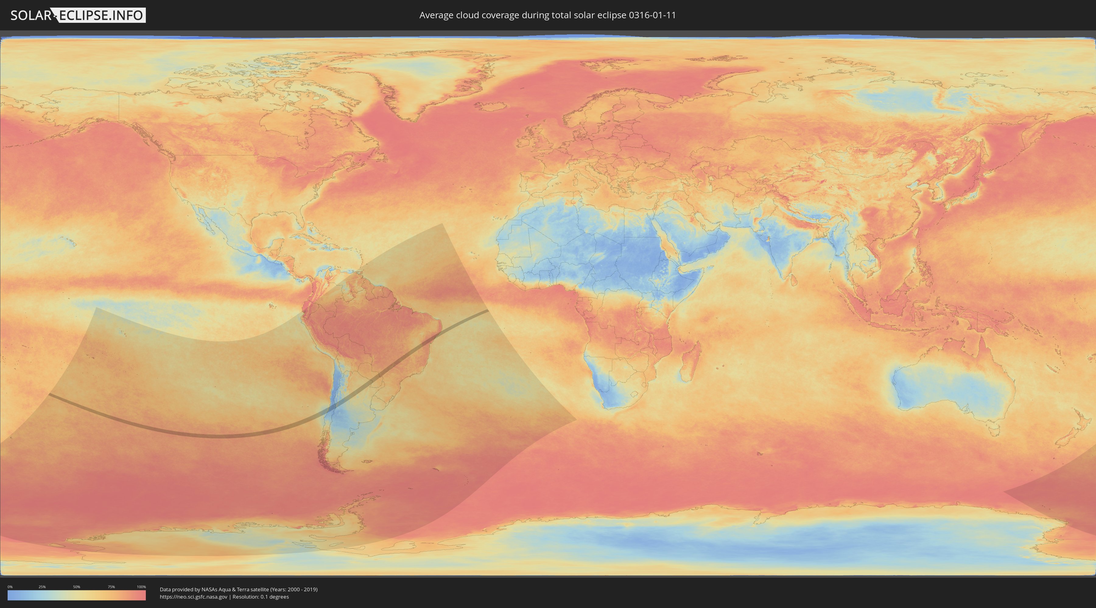
Wie wird das Wetter während der totalen Sonnenfinsternis am 11.01.0316?
Wo ist der beste Ort, um die totale Sonnenfinsternis vom 11.01.0316 zu beobachten?
Die folgenden Karten zeigen die durchschnittliche Bewölkung für den Tag, an dem die totale Sonnenfinsternis
stattfindet. Mit Hilfe der Karten lässt sich der Ort entlang des Finsternispfades eingrenzen,
der die besten Aussichen auf einen klaren wolkenfreien Himmel bietet.
Trotzdem muss man immer lokale Gegenenheiten beachten und sollte sich genau über das Wetter an seinem
gewählten Beobachtungsort informieren.
Die Daten stammen von den beiden NASA-Satelliten
AQUA und TERRA
und wurden über einen Zeitraum von 19 Jahren (2000 - 2019) gemittelt.
Detaillierte Länderkarten
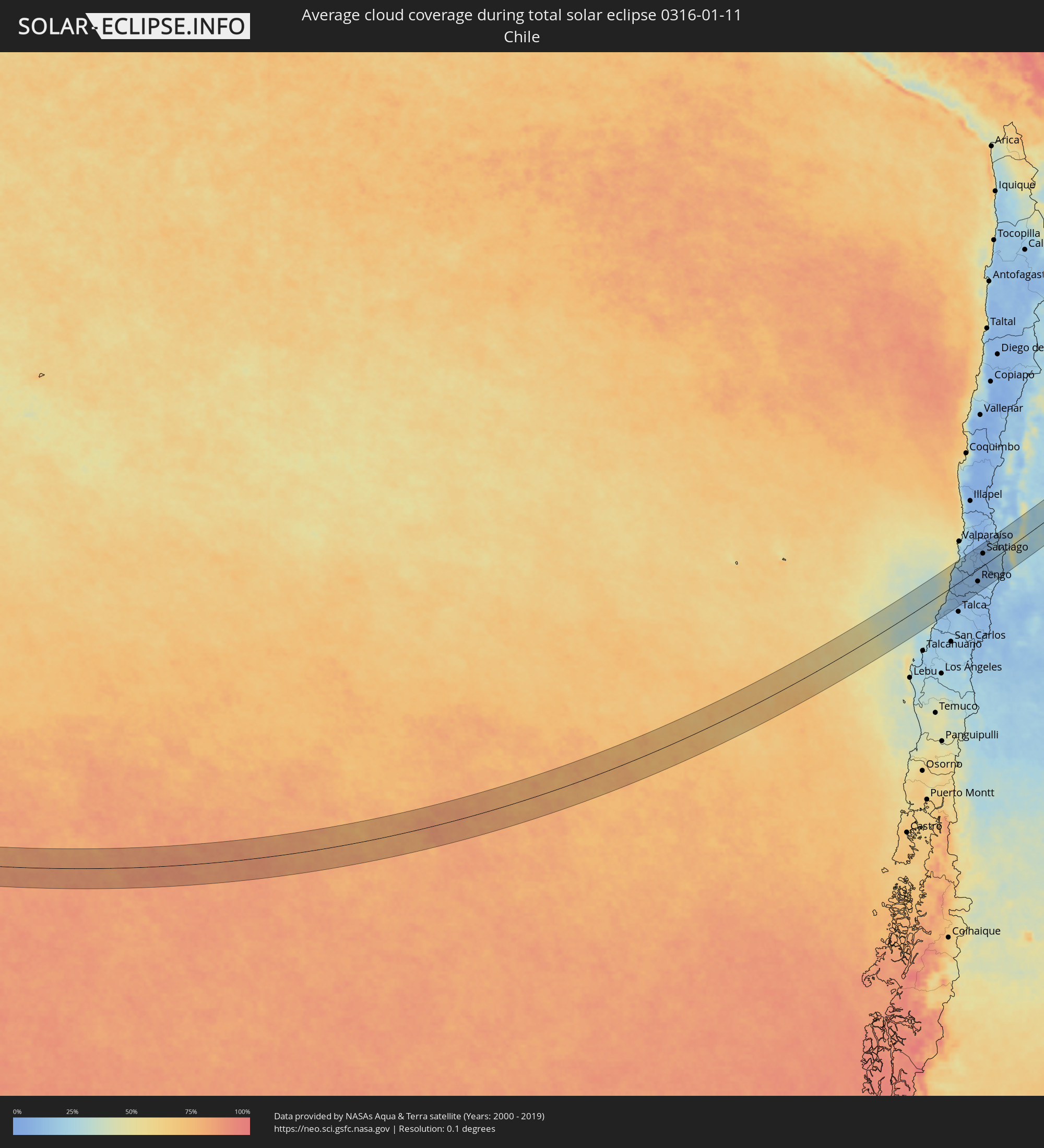 Chile
Chile
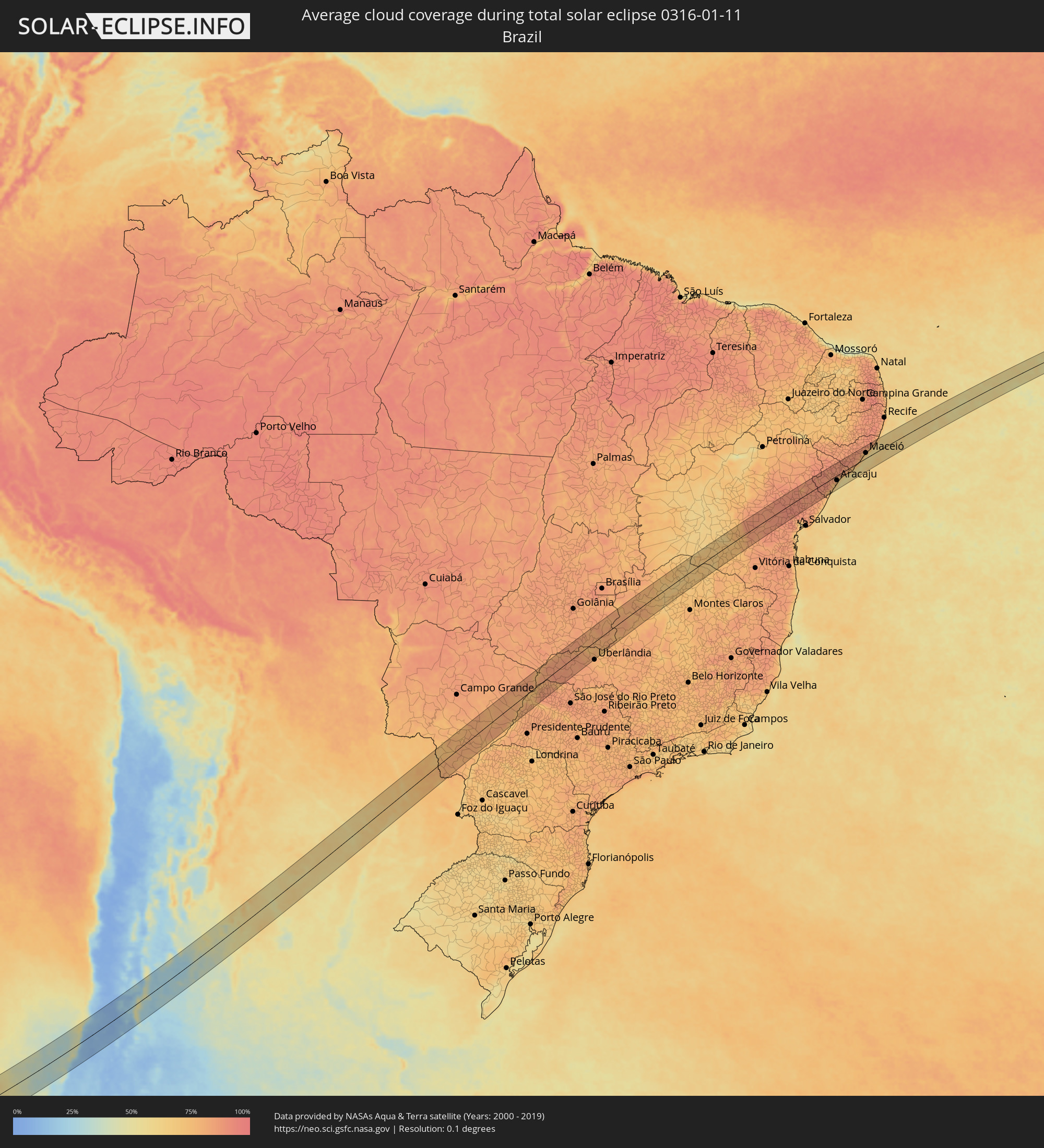 Brasilien
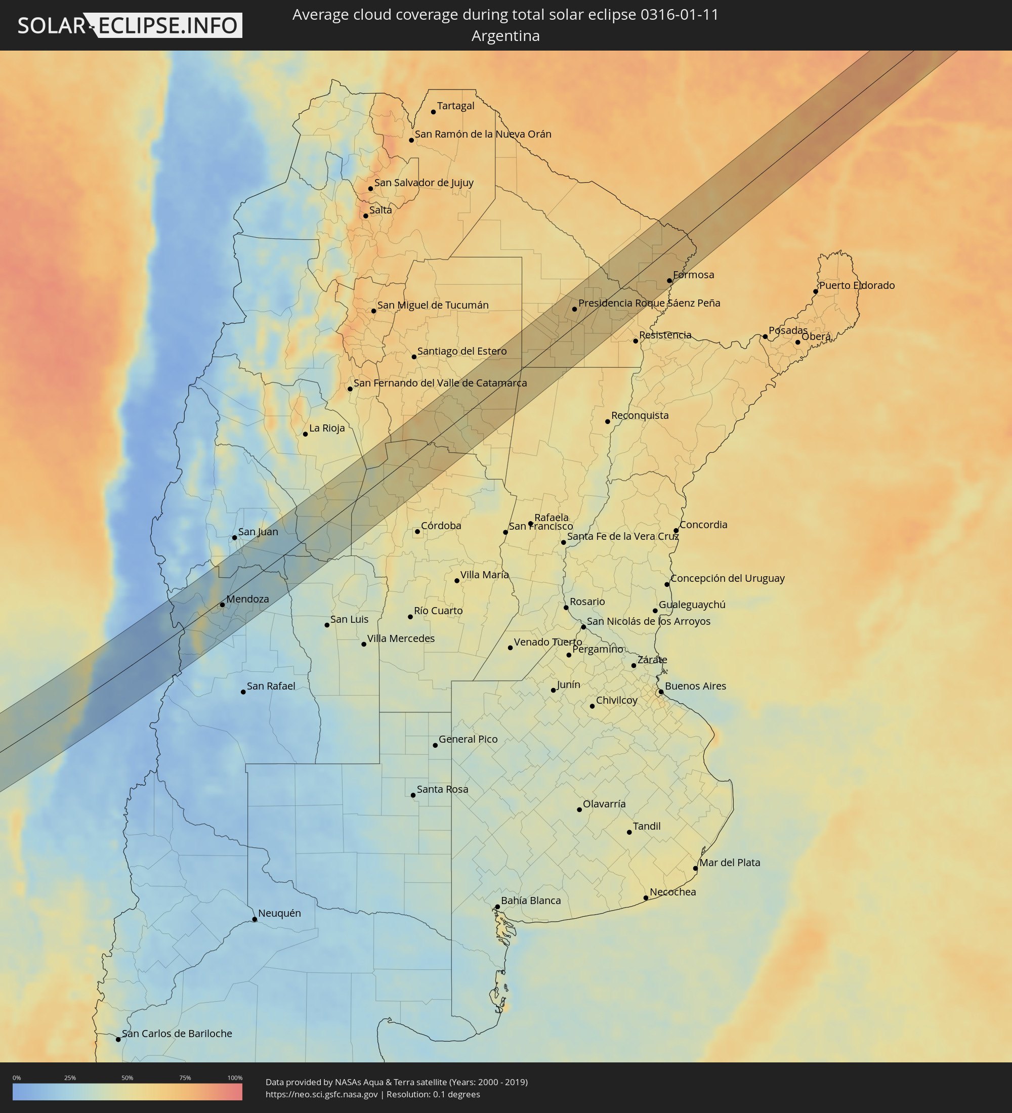 Argentinien
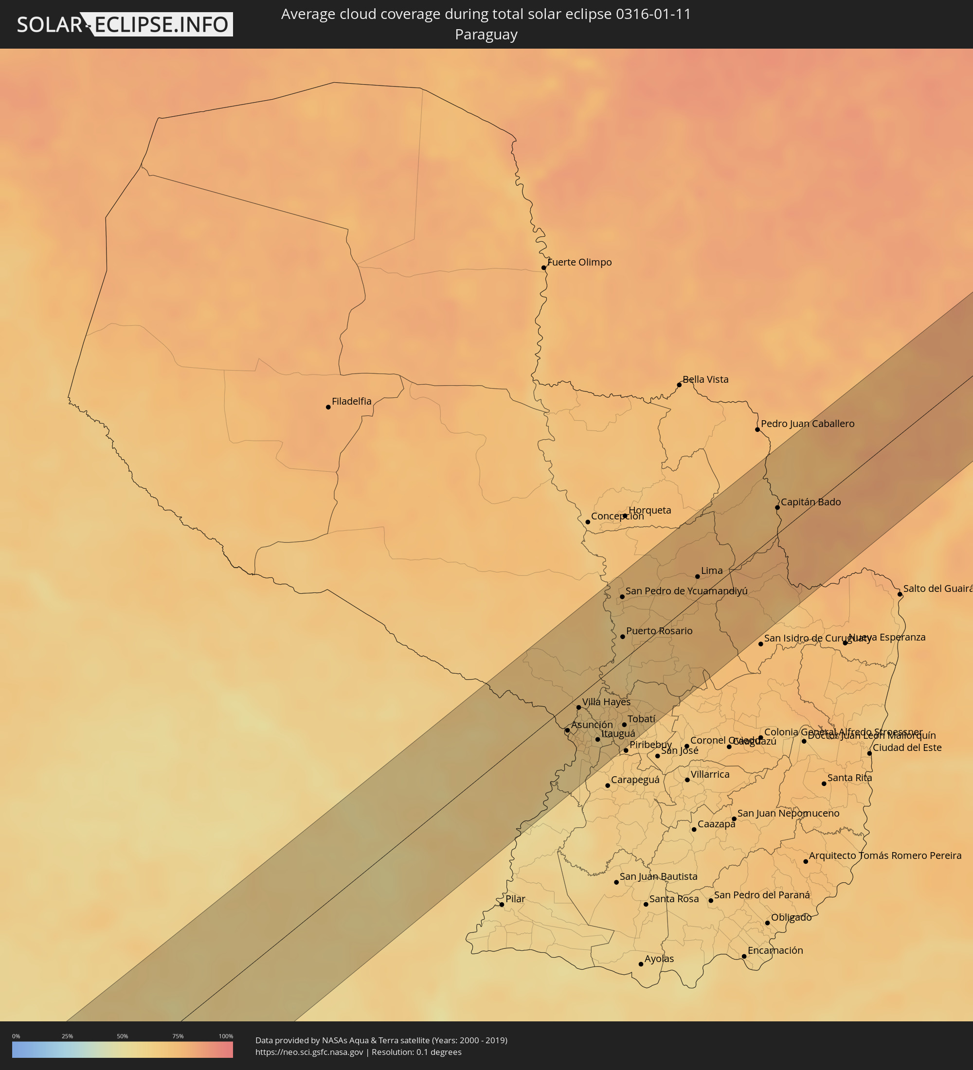 Paraguay
Orte im Finsternispfad
Die nachfolgene Tabelle zeigt Städte und Orte mit mehr als 5.000 Einwohnern, die sich im Finsternispfad befinden. Städte mit mehr als 100.000 Einwohnern sind dick gekennzeichnet. Mit einem Klick auf den Ort öffnet sich eine Detailkarte die die Lage des jeweiligen Ortes zusammen mit dem Verlauf der zentralen Finsternis präsentiert.
| Ort | Typ | Dauer der Verfinsterung | Ortszeit bei maximaler Verfinsterung | Entfernung zur Zentrallinie | Ø Bewölkung |
|
Constitución, Maule
|
total | - | 13:30:07 UTC-04:42 | 44 km | 21% |
|
Santa Cruz, O'Higgins
|
total | - | 13:33:01 UTC-04:42 | 33 km | 11% |
|
Rauco, Maule
|
total | - | 13:32:39 UTC-04:42 | 62 km | 11% |
|
Curicó, Maule
|
total | - | 13:32:41 UTC-04:42 | 71 km | 12% |
|
Melipilla, Santiago Metropolitan
|
total | - | 13:34:46 UTC-04:42 | 46 km | 14% |
|
Teno, Maule
|
total | - | 13:33:00 UTC-04:42 | 65 km | 12% |
|
San Vicente, O'Higgins
|
total | - | 13:33:49 UTC-04:42 | 29 km | 11% |
|
San Vicente de Tagua Tagua, O'Higgins
|
total | - | 13:33:49 UTC-04:42 | 30 km | 11% |
|
Chimbarongo, O'Higgins
|
total | - | 13:33:27 UTC-04:42 | 56 km | 13% |
|
El Monte, Santiago Metropolitan
|
total | - | 13:35:11 UTC-04:42 | 35 km | 11% |
|
Talagante, Santiago Metropolitan
|
total | - | 13:35:19 UTC-04:42 | 34 km | 11% |
|
Peñaflor, Santiago Metropolitan
|
total | - | 13:35:29 UTC-04:42 | 36 km | 11% |
|
Lampa, Santiago Metropolitan
|
total | - | 13:36:00 UTC-04:42 | 65 km | 8% |
|
Rengo, O'Higgins
|
total | - | 13:34:15 UTC-04:42 | 38 km | 11% |
|
Rancagua, O'Higgins
|
total | - | 13:34:49 UTC-04:42 | 22 km | 9% |
|
Buin, Santiago Metropolitan
|
total | - | 13:35:31 UTC-04:42 | 18 km | 9% |
|
Paine, Santiago Metropolitan
|
total | - | 13:35:24 UTC-04:42 | 11 km | 9% |
|
Graneros, O'Higgins
|
total | - | 13:35:00 UTC-04:42 | 14 km | 9% |
|
Lo Prado, Santiago Metropolitan
|
total | - | 13:36:00 UTC-04:42 | 43 km | 9% |
|
San Bernardo, Santiago Metropolitan
|
total | - | 13:35:49 UTC-04:42 | 28 km | 10% |
|
Chicureo Abajo, Santiago Metropolitan
|
total | - | 13:36:23 UTC-04:42 | 54 km | 8% |
|
Machalí, O'Higgins
|
total | - | 13:34:57 UTC-04:42 | 28 km | 9% |
|
Santiago, Santiago Metropolitan
|
total | - | 13:36:07 UTC-04:42 | 38 km | 9% |
|
La Pintana, Santiago Metropolitan
|
total | - | 13:35:56 UTC-04:42 | 25 km | 10% |
|
Villa Presidente Frei, Ñuñoa, Santiago, Chile, Santiago Metropolitan
|
total | - | 13:36:14 UTC-04:42 | 34 km | 9% |
|
Puente Alto, Santiago Metropolitan
|
total | - | 13:36:00 UTC-04:42 | 20 km | 10% |
|
Mendoza, Mendoza Province
|
total | - | 14:06:03 UTC-04:16 | 9 km | 33% |
|
San Martín, Mendoza Province
|
total | - | 14:06:20 UTC-04:16 | 46 km | 27% |
|
Villa de Soto, Cordoba Province
|
total | - | 14:15:29 UTC-04:16 | 47 km | 50% |
|
Cruz del Eje, Cordoba Province
|
total | - | 14:15:59 UTC-04:16 | 47 km | 50% |
|
Deán Funes, Cordoba Province
|
total | - | 14:17:11 UTC-04:16 | 47 km | 51% |
|
Villa Ojo de Agua, Santiago del Estero Province
|
total | - | 14:19:43 UTC-04:16 | 6 km | 54% |
|
Añatuya, Santiago del Estero Province
|
total | - | 14:22:43 UTC-04:16 | 33 km | 54% |
|
Hermoso Campo, Chaco Province
|
total | - | 14:26:14 UTC-04:16 | 15 km | 58% |
|
General Pinedo, Chaco Province
|
total | - | 14:26:49 UTC-04:16 | 36 km | 57% |
|
Charata, Chaco Province
|
total | - | 14:27:07 UTC-04:16 | 39 km | 58% |
|
Santa Sylvina, Chaco Province
|
total | - | 14:26:07 UTC-04:16 | 17 km | 59% |
|
Las Breñas, Chaco Province
|
total | - | 14:27:28 UTC-04:16 | 43 km | 58% |
|
Corzuela, Chaco Province
|
total | - | 14:27:51 UTC-04:16 | 48 km | 59% |
|
Coronel Du Graty, Chaco Province
|
total | - | 14:26:40 UTC-04:16 | 18 km | 57% |
|
Campo Largo, Chaco Province
|
total | - | 14:28:17 UTC-04:16 | 53 km | 61% |
|
Aviá Terai, Chaco Province
|
total | - | 14:28:38 UTC-04:16 | 56 km | 60% |
|
Villa Ángela, Chaco Province
|
total | - | 14:27:07 UTC-04:16 | 21 km | 58% |
|
San Bernardo, Chaco Province
|
total | - | 14:27:37 UTC-04:16 | 3 km | 58% |
|
Presidencia Roque Sáenz Peña, Chaco Province
|
total | - | 14:28:50 UTC-04:16 | 29 km | 60% |
|
Tres Isletas, Chaco Province
|
total | - | 14:29:36 UTC-04:16 | 67 km | 59% |
|
Villa Berthet, Chaco Province
|
total | - | 14:28:00 UTC-04:16 | 16 km | 58% |
|
Quitilipi, Chaco Province
|
total | - | 14:28:58 UTC-04:16 | 8 km | 60% |
|
Machagai, Chaco Province
|
total | - | 14:29:05 UTC-04:16 | 7 km | 59% |
|
Pampa del Indio, Chaco Province
|
total | - | 14:30:44 UTC-04:16 | 59 km | 58% |
|
Presidencia de la Plaza, Chaco Province
|
total | - | 14:29:13 UTC-04:16 | 27 km | 58% |
|
El Colorado, Formosa Province
|
total | - | 14:31:00 UTC-04:16 | 4 km | 54% |
|
General José de San Martín, Chaco Province
|
total | - | 14:30:38 UTC-04:16 | 18 km | 57% |
|
Palo Santo, Formosa Province
|
total | - | 14:32:19 UTC-04:16 | 66 km | 57% |
|
Pirané, Formosa Province
|
total | - | 14:32:18 UTC-04:16 | 36 km | 59% |
|
Formosa, Formosa Province
|
total | - | 14:32:40 UTC-04:16 | 61 km | 57% |
|
Clorinda, Formosa Province
|
total | - | 14:34:43 UTC-04:16 | 13 km | 64% |
|
Nanawa, Presidente Hayes
|
total | - | 15:00:57 UTC-03:50 | 15 km | 64% |
|
Asunción, Asunción
|
total | - | 15:00:55 UTC-03:50 | 20 km | 68% |
|
Lambaré, Central
|
total | - | 15:00:53 UTC-03:50 | 26 km | 68% |
|
Villa Elisa, Central
|
total | - | 15:00:51 UTC-03:50 | 29 km | 62% |
|
Benjamín Aceval, Presidente Hayes
|
total | - | 15:01:34 UTC-03:50 | 4 km | 67% |
|
Colonia Mariano Roque Alonso, Central
|
total | - | 15:01:15 UTC-03:50 | 14 km | 68% |
|
San Antonio, Central
|
total | - | 15:00:49 UTC-03:50 | 36 km | 63% |
|
Nemby, Central
|
total | - | 15:00:53 UTC-03:50 | 35 km | 63% |
|
Villa Hayes, Presidente Hayes
|
total | - | 15:01:24 UTC-03:50 | 9 km | 63% |
|
Fernando de la Mora, Central
|
total | - | 15:00:59 UTC-03:50 | 31 km | 69% |
|
San Lorenzo, Central
|
total | - | 15:01:00 UTC-03:50 | 32 km | 69% |
|
Limpio, Central
|
total | - | 15:01:19 UTC-03:50 | 18 km | 67% |
|
Guarambaré, Central
|
total | - | 15:00:48 UTC-03:50 | 47 km | 62% |
|
Capiatá, Central
|
total | - | 15:01:03 UTC-03:50 | 37 km | 65% |
|
Areguá, Central
|
total | - | 15:01:11 UTC-03:50 | 37 km | 64% |
|
Itá, Central
|
total | - | 15:00:53 UTC-03:50 | 54 km | 62% |
|
Emboscada, Cordillera
|
total | - | 15:01:30 UTC-03:50 | 25 km | 63% |
|
Itauguá, Central
|
total | - | 15:01:08 UTC-03:50 | 47 km | 64% |
|
Yaguarón, Paraguarí
|
total | - | 15:00:48 UTC-03:50 | 67 km | 64% |
|
Ypacarai, Central
|
total | - | 15:01:08 UTC-03:50 | 51 km | 64% |
|
Caacupé, Cordillera
|
total | - | 15:01:20 UTC-03:50 | 59 km | 67% |
|
San Pedro de Ycuamandiyú, San Pedro
|
total | - | 15:03:36 UTC-03:50 | 50 km | 66% |
|
Puerto Rosario, San Pedro
|
total | - | 15:02:59 UTC-03:50 | 18 km | 63% |
|
Tobatí, Cordillera
|
total | - | 15:01:39 UTC-03:50 | 52 km | 67% |
|
Lima, San Pedro
|
total | - | 15:04:44 UTC-03:50 | 17 km | 75% |
|
Capitán Bado, Amambay
|
total | - | 15:06:39 UTC-03:50 | 20 km | 74% |
|
Dourados, Mato Grosso do Sul
|
total | - | 15:21:19 UTC-03:38 | 64 km | 78% |
|
Naviraí, Mato Grosso do Sul
|
total | - | 15:20:33 UTC-03:38 | 49 km | 79% |
|
Três Lagoas, Mato Grosso do Sul
|
total | - | 15:26:31 UTC-03:38 | 13 km | 77% |
|
Andradina, São Paulo
|
total | - | 15:58:37 UTC-03:06 | 43 km | 82% |
|
Ilha Solteira, São Paulo
|
total | - | 15:59:23 UTC-03:06 | 5 km | 71% |
|
Paranaíba, Mato Grosso do Sul
|
total | - | 15:28:41 UTC-03:38 | 51 km | 82% |
|
Pereira Barreto, São Paulo
|
total | - | 15:59:15 UTC-03:06 | 38 km | 75% |
|
Santa Fé do Sul, São Paulo
|
total | - | 16:00:04 UTC-03:06 | 13 km | 79% |
|
Jales, São Paulo
|
total | - | 16:00:18 UTC-03:06 | 42 km | 85% |
|
Fernandópolis, São Paulo
|
total | - | 16:00:31 UTC-03:06 | 63 km | 88% |
|
Iturama, Minas Gerais
|
total | - | 16:01:25 UTC-03:06 | 17 km | 84% |
|
Ituiutaba, Minas Gerais
|
total | - | 16:03:08 UTC-03:06 | 2 km | 85% |
|
Itumbiara, Goiás
|
total | - | 16:04:09 UTC-03:06 | 35 km | 79% |
|
Tupaciguara, Minas Gerais
|
total | - | 16:04:16 UTC-03:06 | 13 km | 81% |
|
Caldas Novas, Goiás
|
total | - | 16:05:34 UTC-03:06 | 57 km | 79% |
|
Araguari, Minas Gerais
|
total | - | 16:04:33 UTC-03:06 | 51 km | 77% |
|
Catalão, Goiás
|
total | - | 16:05:26 UTC-03:06 | 24 km | 78% |
|
Paracatu, Minas Gerais
|
total | - | 16:07:31 UTC-03:06 | 8 km | 84% |
|
São Francisco, Minas Gerais
|
total | - | 16:10:30 UTC-03:06 | 20 km | 65% |
|
Januária, Minas Gerais
|
total | - | 16:11:24 UTC-03:06 | 10 km | 63% |
|
Guanambi, Bahia
|
total | - | 16:46:20 UTC-02:34 | 9 km | 68% |
|
Caetité, Bahia
|
total | - | 16:46:40 UTC-02:34 | 4 km | 73% |
|
Brumado, Bahia
|
total | - | 16:46:51 UTC-02:34 | 58 km | 72% |
|
Vera Cruz, Bahia
|
total | - | 16:49:05 UTC-02:34 | 50 km | 87% |
|
Ruy Barbosa, Bahia
|
total | - | 16:49:42 UTC-02:34 | 50 km | 85% |
|
Itaberaba, Bahia
|
total | - | 16:49:29 UTC-02:34 | 16 km | 88% |
|
Iaçu, Bahia
|
total | - | 16:49:13 UTC-02:34 | 12 km | 86% |
|
Ipirá, Bahia
|
total | - | 16:50:07 UTC-02:34 | 17 km | 90% |
|
Conceição do Coité, Bahia
|
total | - | 16:50:59 UTC-02:34 | 46 km | 88% |
|
Santo Estêvão, Bahia
|
total | - | 16:49:57 UTC-02:34 | 37 km | 88% |
|
Serrinha, Bahia
|
total | - | 16:50:57 UTC-02:34 | 20 km | 89% |
|
Feira de Santana, Bahia
|
total | - | 16:50:15 UTC-02:34 | 39 km | 91% |
|
Conceição do Jacuípe, Bahia
|
total | - | 16:50:15 UTC-02:34 | 55 km | 89% |
|
Alagoinhas, Bahia
|
total | - | 16:50:34 UTC-02:34 | 58 km | 87% |
|
Tobias Barreto, Sergipe
|
total | - | 16:51:48 UTC-02:34 | 7 km | 90% |
|
Rio Real, Bahia
|
total | - | 16:51:28 UTC-02:34 | 25 km | 86% |
|
Lagarto, Sergipe
|
total | - | 16:52:12 UTC-02:34 | 12 km | 91% |
|
Estância, Sergipe
|
total | - | 16:51:51 UTC-02:34 | 33 km | 67% |
|
Itabaiana, Sergipe
|
total | - | 16:52:31 UTC-02:34 | 21 km | 85% |
|
São Cristóvão, Sergipe
|
total | - | 16:52:12 UTC-02:34 | 23 km | 70% |
|
Laranjeiras, Sergipe
|
total | - | 16:52:27 UTC-02:34 | 5 km | 82% |
|
Aracaju, Sergipe
|
total | - | 16:52:21 UTC-02:34 | 20 km | 72% |
|
Propriá, Sergipe
|
total | - | 16:53:11 UTC-02:34 | 33 km | 84% |
|
Penedo, Alagoas
|
total | - | 16:53:09 UTC-02:34 | 11 km | 81% |
|
Coruripe, Alagoas
|
total | - | 16:53:26 UTC-02:34 | 4 km | 74% |
|
São Miguel dos Campos, Alagoas
|
total | - | 16:53:49 UTC-02:34 | 32 km | 82% |
|
Marechal Deodoro, Alagoas
|
total | - | 16:53:56 UTC-02:34 | 28 km | 72% |
|
Rio Largo, Alagoas
|
total | - | 16:54:12 UTC-02:34 | 48 km | 82% |
|
Maceió, Alagoas
|
total | - | 16:54:01 UTC-02:34 | 23 km | 58% |
|
São Luís do Quitunde, Alagoas
|
total | - | 16:54:25 UTC-02:34 | 47 km | 79% |