Totale Sonnenfinsternis vom 20.11.0393
| Wochentag: | Samstag |
| Maximale Dauer der Verfinsterung: | 03m05s |
| Maximale Breite des Finsternispfades: | 250 km |
| Saroszyklus: | 97 |
| Bedeckungsgrad: | 100% |
| Magnitude: | 1.0373 |
| Gamma: | 0.864 |
Wo kann man die Sonnenfinsternis vom 20.11.0393 sehen?
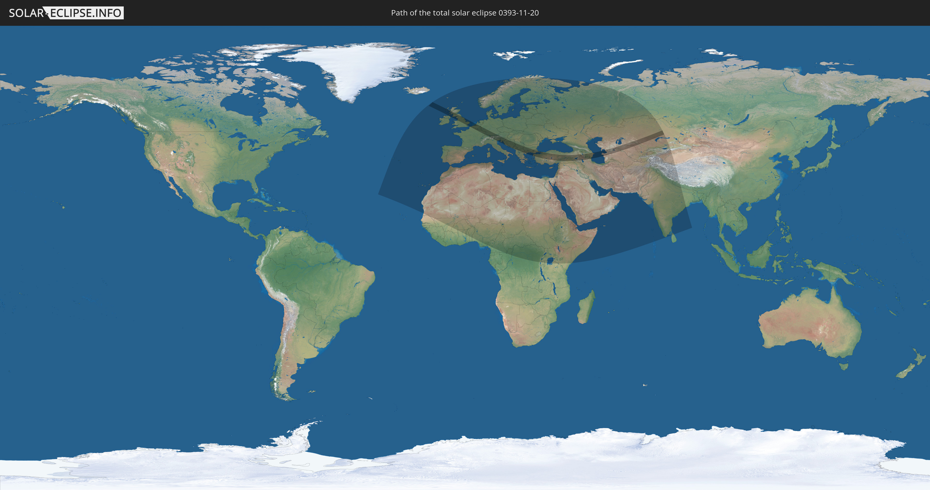
Die Sonnenfinsternis am 20.11.0393 kann man in 108 Ländern als partielle Sonnenfinsternis beobachten.
Der Finsternispfad verläuft durch 27 Länder. Nur in diesen Ländern ist sie als totale Sonnenfinsternis zu sehen.
In den folgenden Ländern ist die Sonnenfinsternis total zu sehen
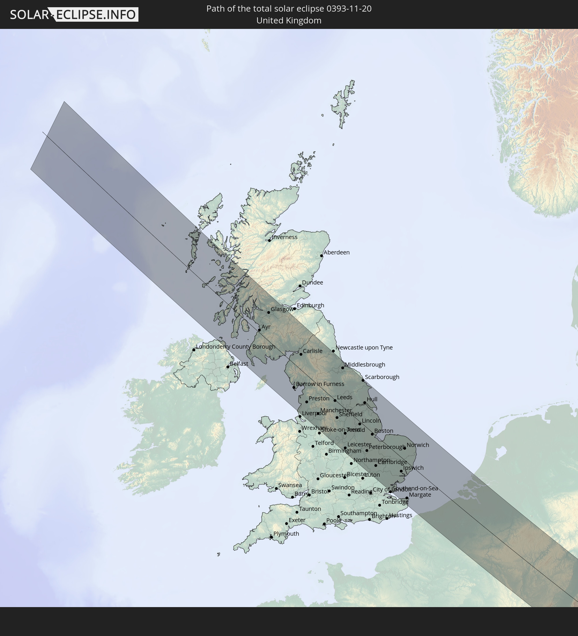 Vereinigtes Königreich
 Frankreich
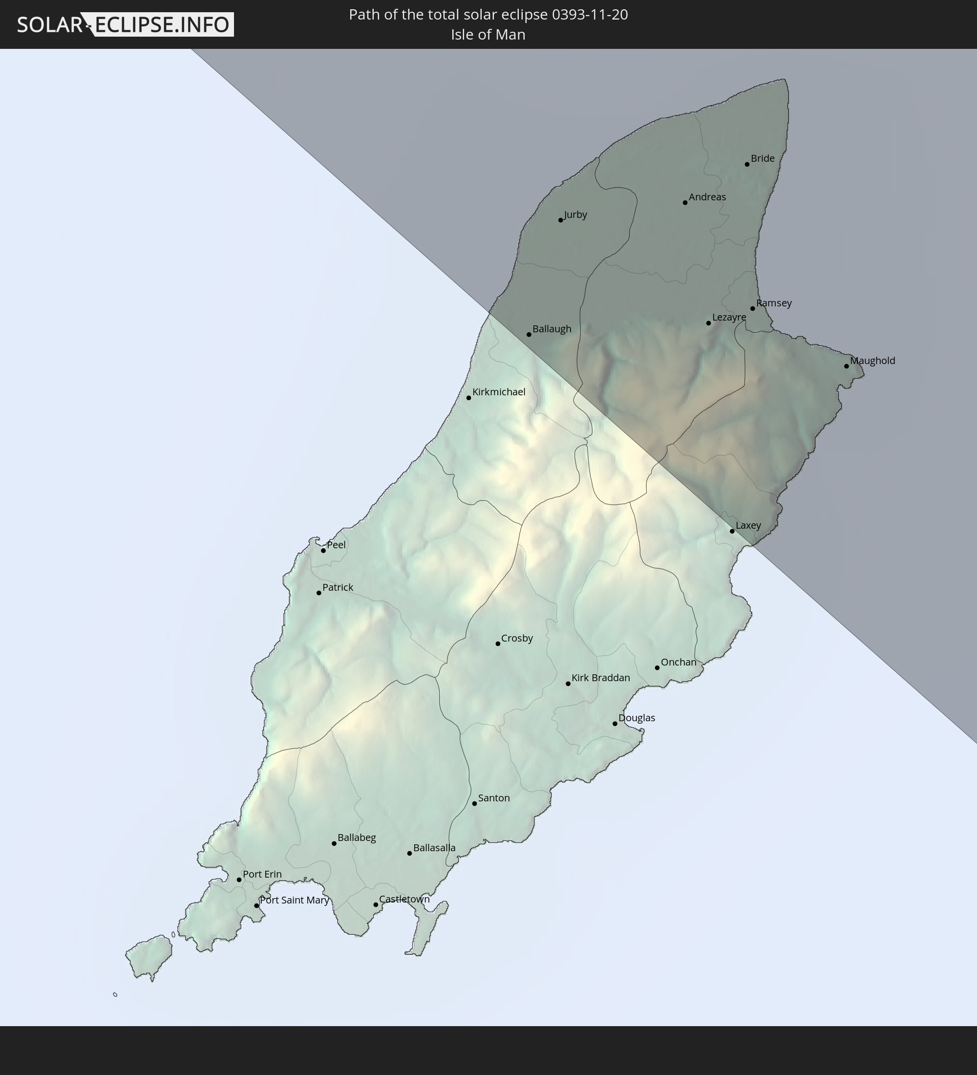 Isle of Man
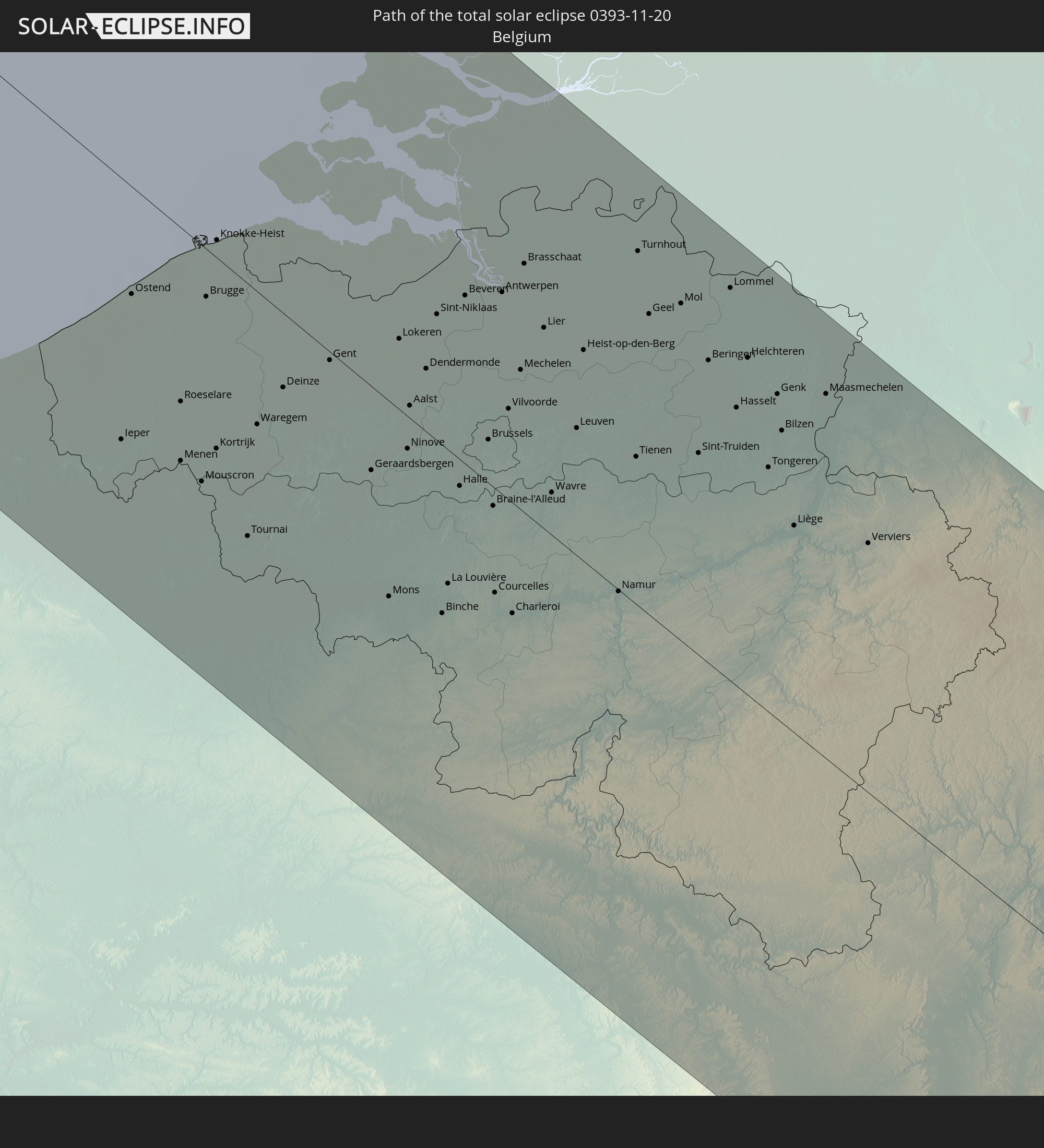 Belgien
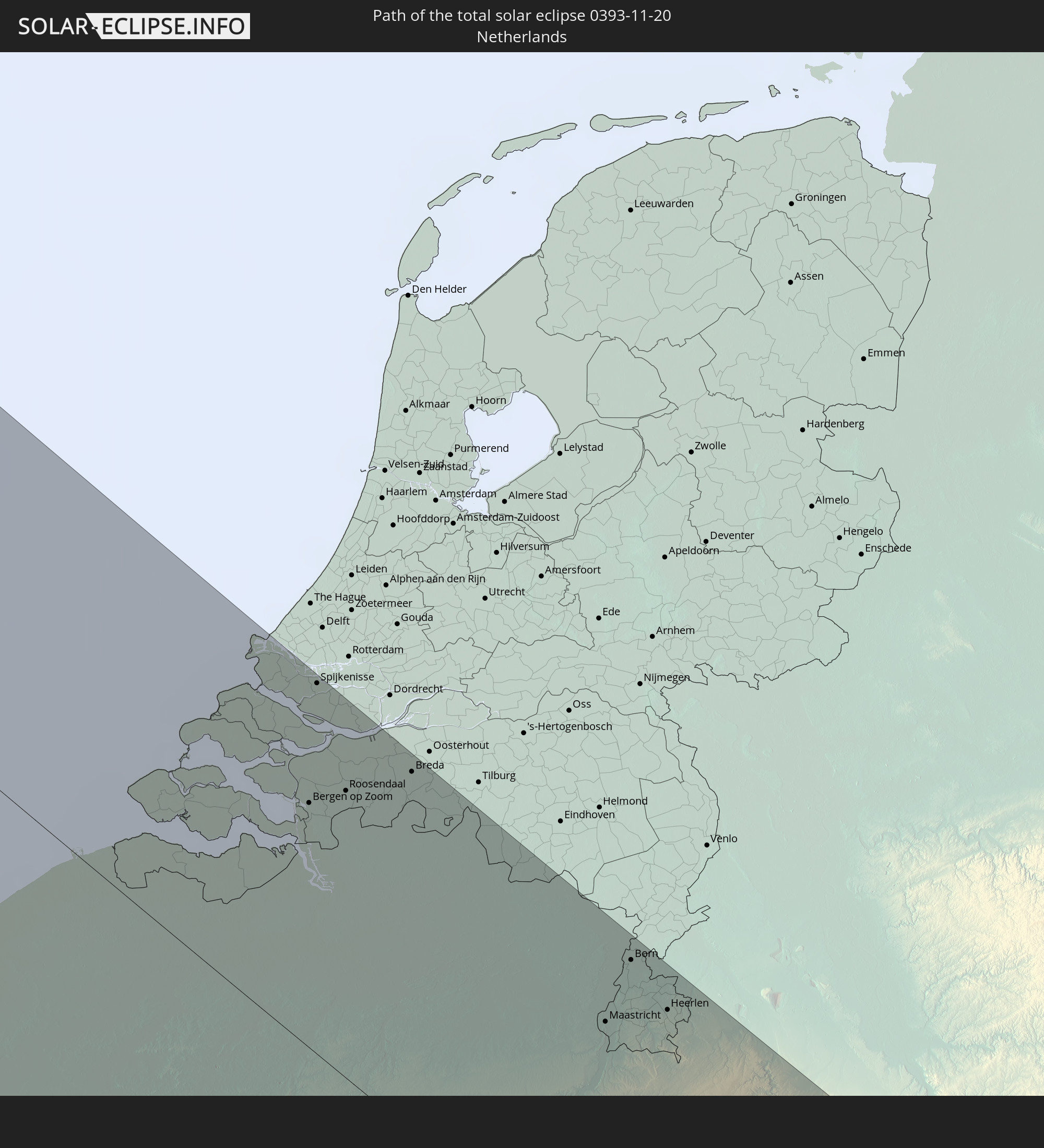 Niederlande
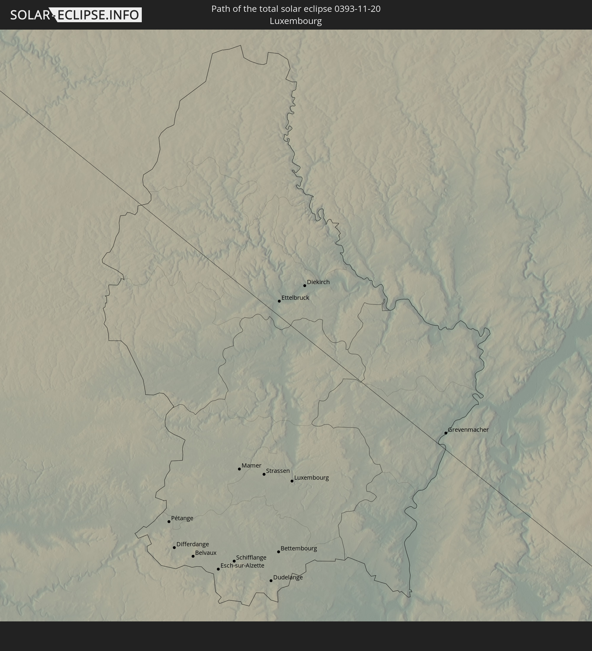 Luxemburg
 Deutschland
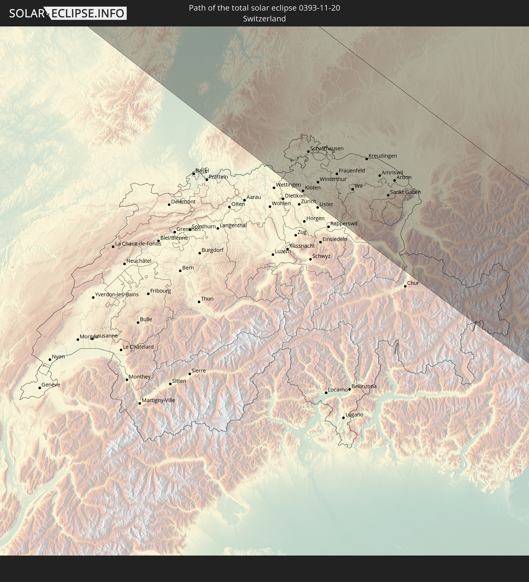 Schweiz
 Italien
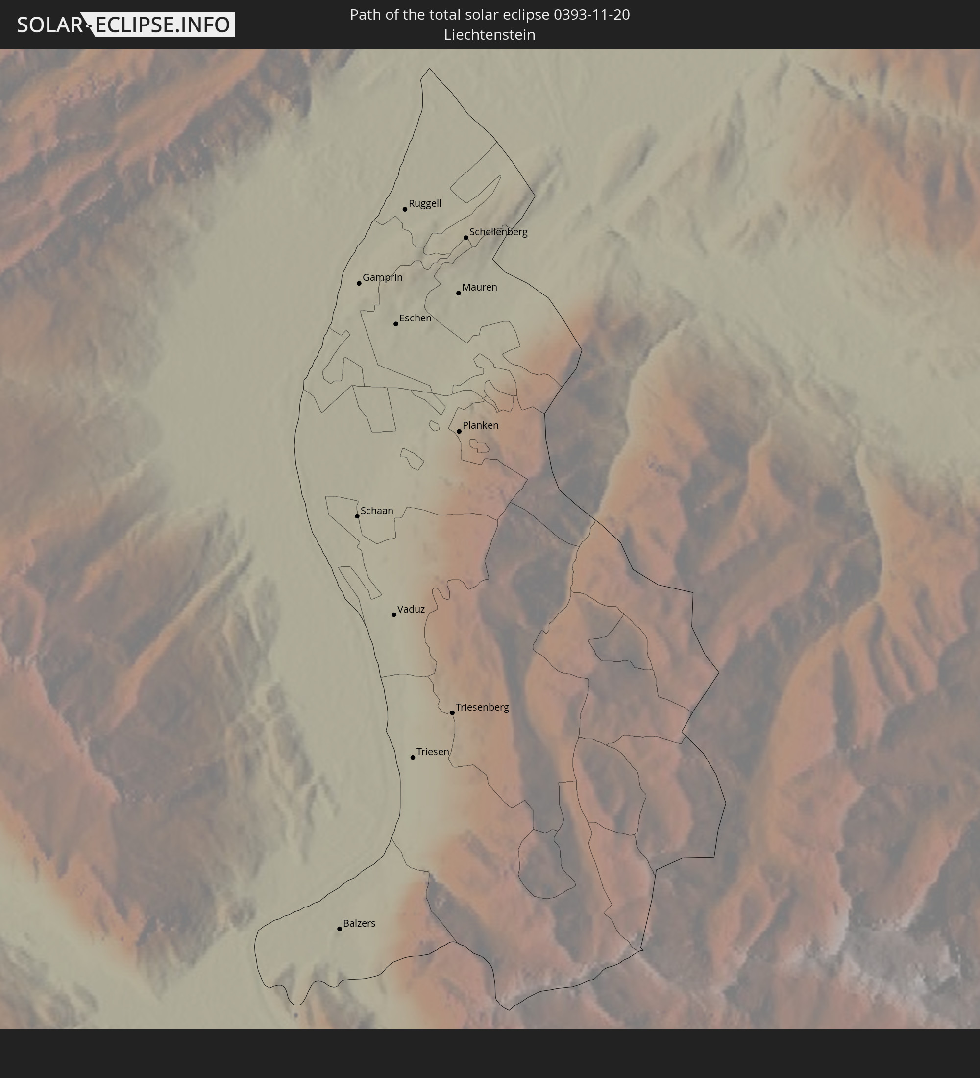 Liechtenstein
 Österreich
 Slowenien
 Kroatien
 Bosnien und Herzegowina
 Montenegro
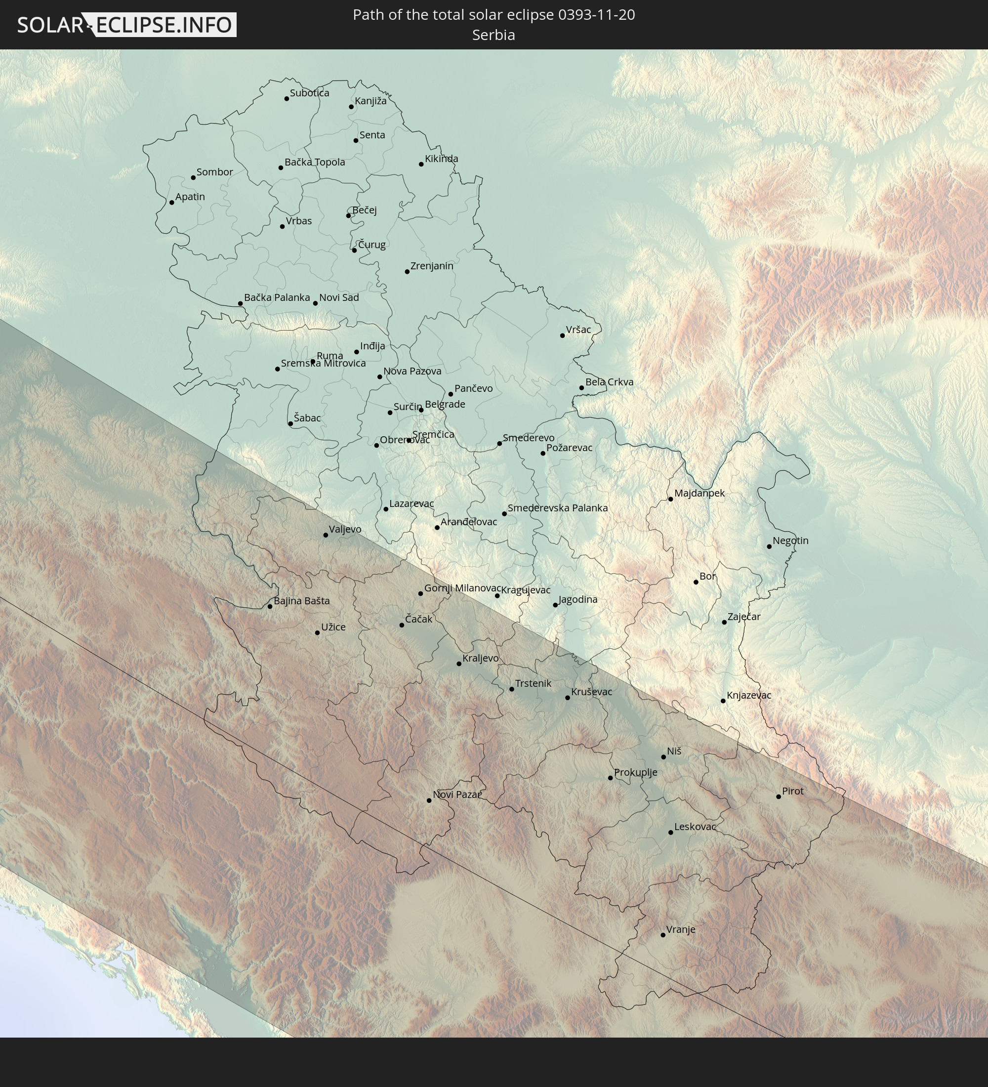 Serbien
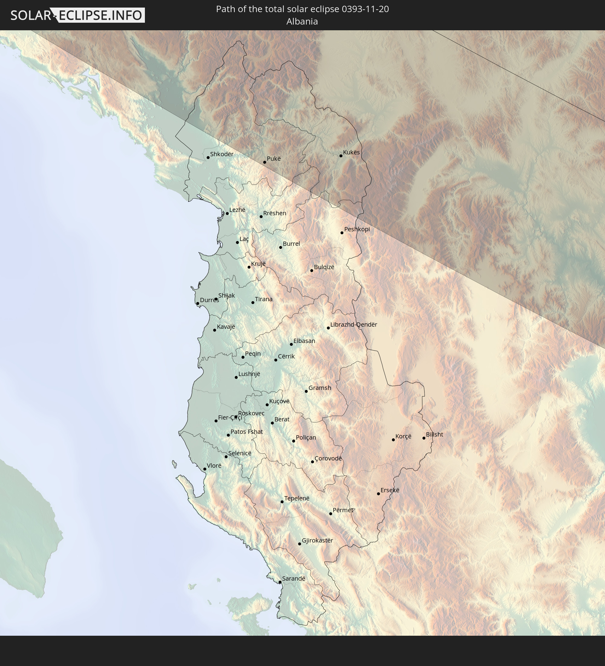 Albanien
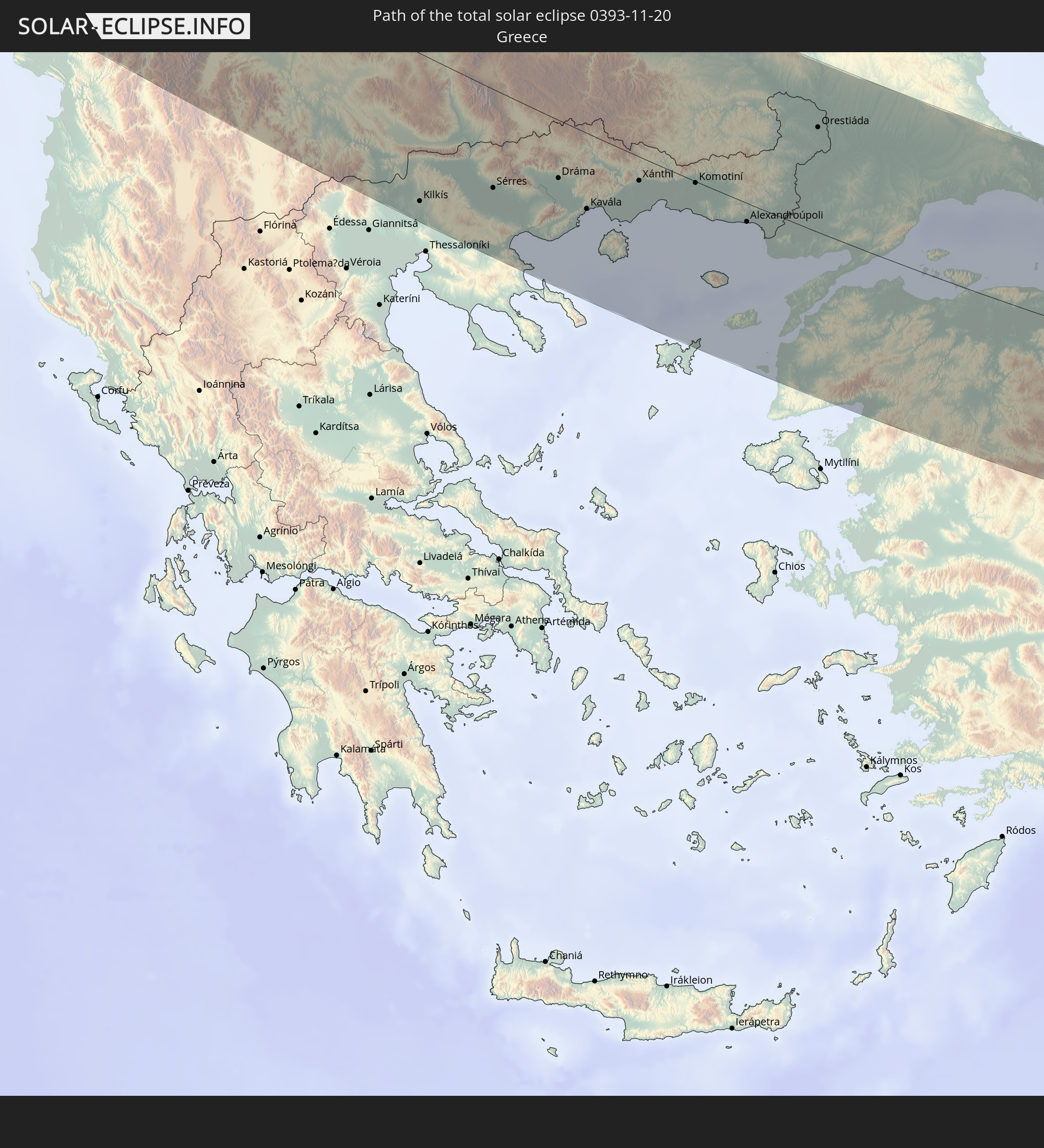 Griechenland
 Mazedonien
 Bulgarien
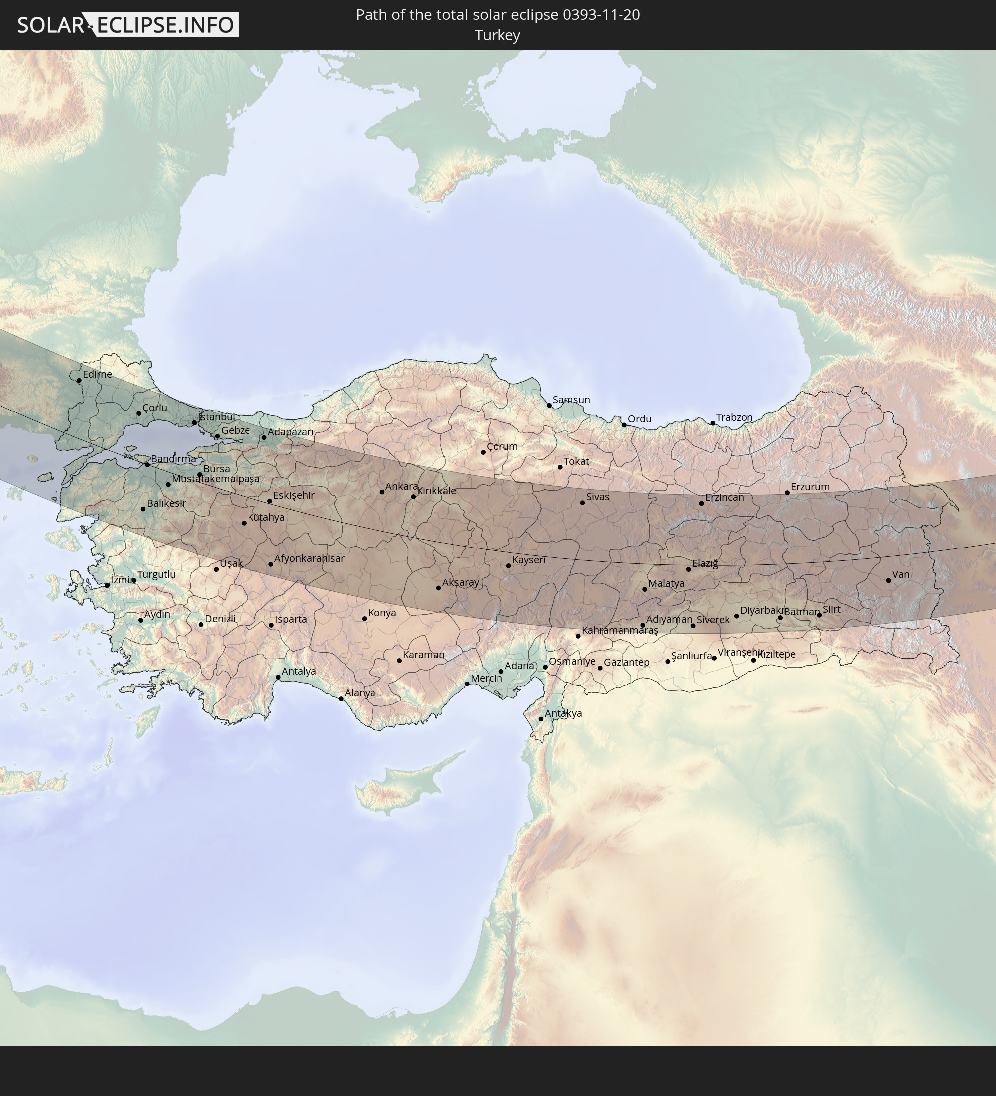 Türkei
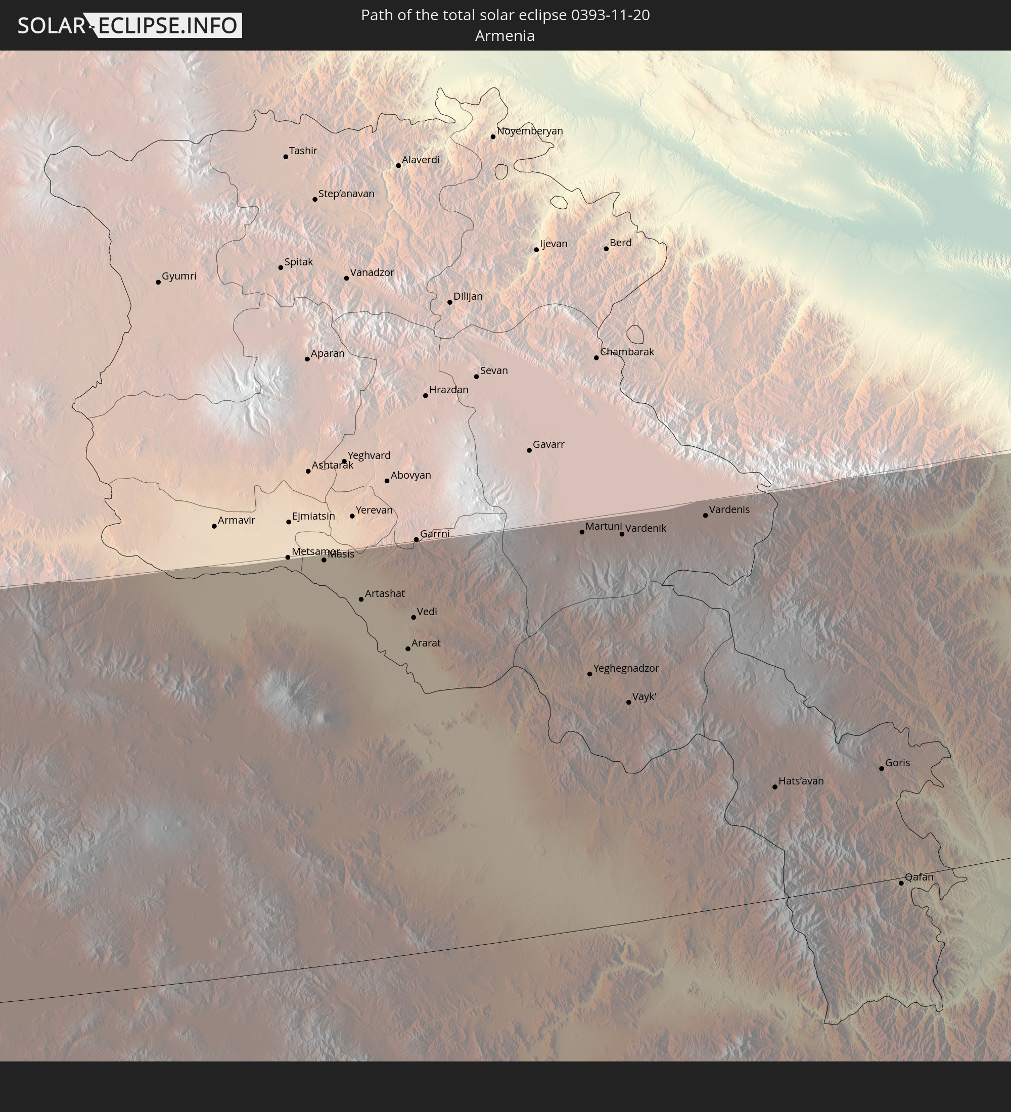 Armenien
 Iran
Iran
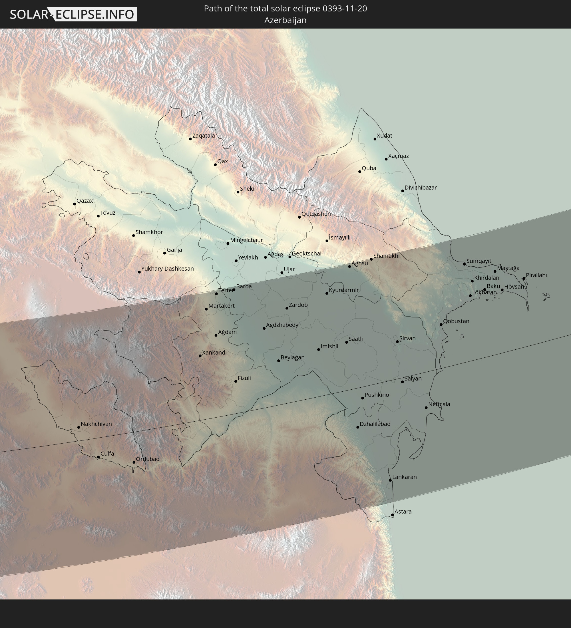 Aserbaidschan
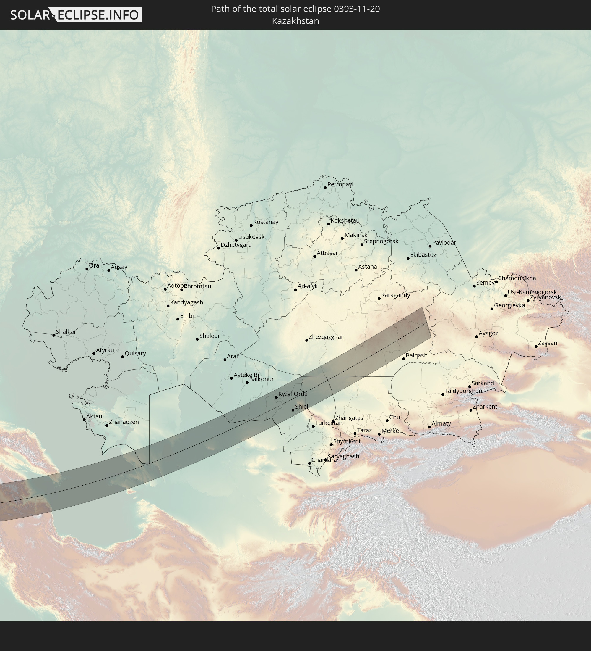 Kasachstan
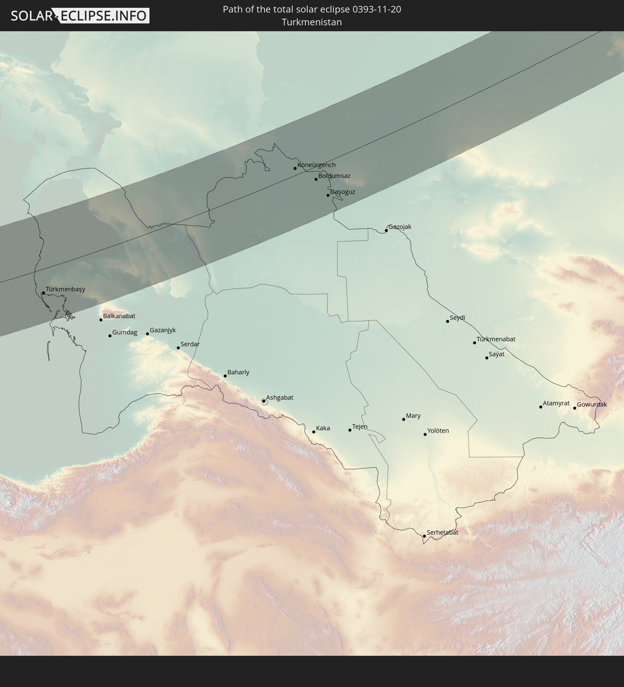 Turkmenistan
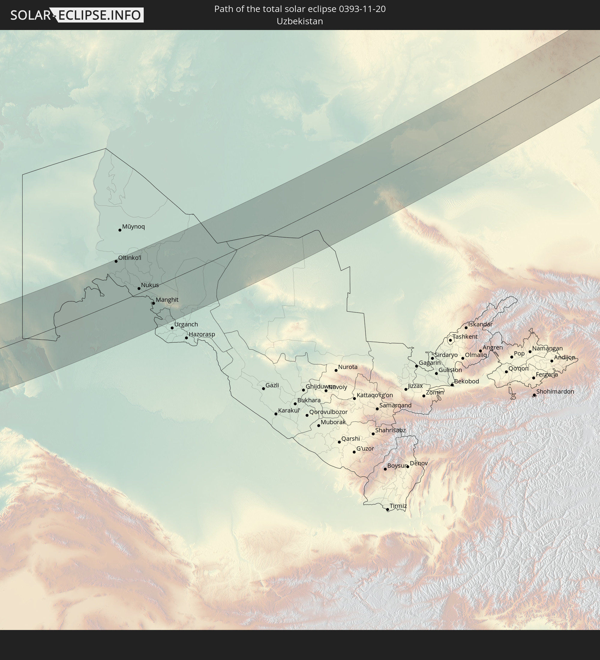 Usbekistan
In den folgenden Ländern ist die Sonnenfinsternis partiell zu sehen
 Russland
 Portugal
 Spanien
 Senegal
 Mauretanien
 Marokko
 Mali
Mali
 Irland
 Algerien
 Vereinigtes Königreich
 Färöer
 Burkina Faso
 Gibraltar
 Frankreich
 Isle of Man
 Ghana
Ghana
 Guernsey
 Jersey
 Togo
Togo
 Niger
Niger
 Benin
Benin
 Andorra
 Belgien
 Nigeria
 Niederlande
 Norwegen
 Luxemburg
 Deutschland
 Schweiz
 Italien
 Monaco
 Tunesien
 Dänemark
 Kamerun
 Libyen
 Liechtenstein
 Österreich
 Schweden
 Republik Kongo
 Tschechien
 Demokratische Republik Kongo
 San Marino
 Vatikanstadt
 Slowenien
 Tschad
 Kroatien
 Polen
Polen
 Malta
Malta
 Zentralafrikanische Republik
 Bosnien und Herzegowina
 Ungarn
 Slowakei
 Montenegro
 Serbien
 Albanien
 Åland Islands
 Griechenland
 Rumänien
 Mazedonien
 Finnland
 Litauen
 Lettland
 Estland
 Sudan
Sudan
 Ukraine
 Bulgarien
 Weißrussland
 Ägypten
 Türkei
 Moldawien
 Ruanda
 Tansania
 Uganda
 Republik Zypern
 Äthiopien
 Kenia
Kenia
 Staat Palästina
 Israel
 Saudi-Arabien
 Jordanien
 Libanon
 Syrien
 Eritrea
 Irak
Irak
 Georgien
 Somalia
 Dschibuti
 Jemen
Jemen
 Armenien
 Iran
Iran
 Aserbaidschan
 Kasachstan
 Kuwait
 Bahrain
 Katar
Katar
 Vereinigte Arabische Emirate
 Oman
Oman
 Turkmenistan
 Usbekistan
 Afghanistan
 Pakistan
 Tadschikistan
 Indien
 Kirgisistan
 Malediven
 Volksrepublik China
 Sri Lanka
 Nepal
Nepal
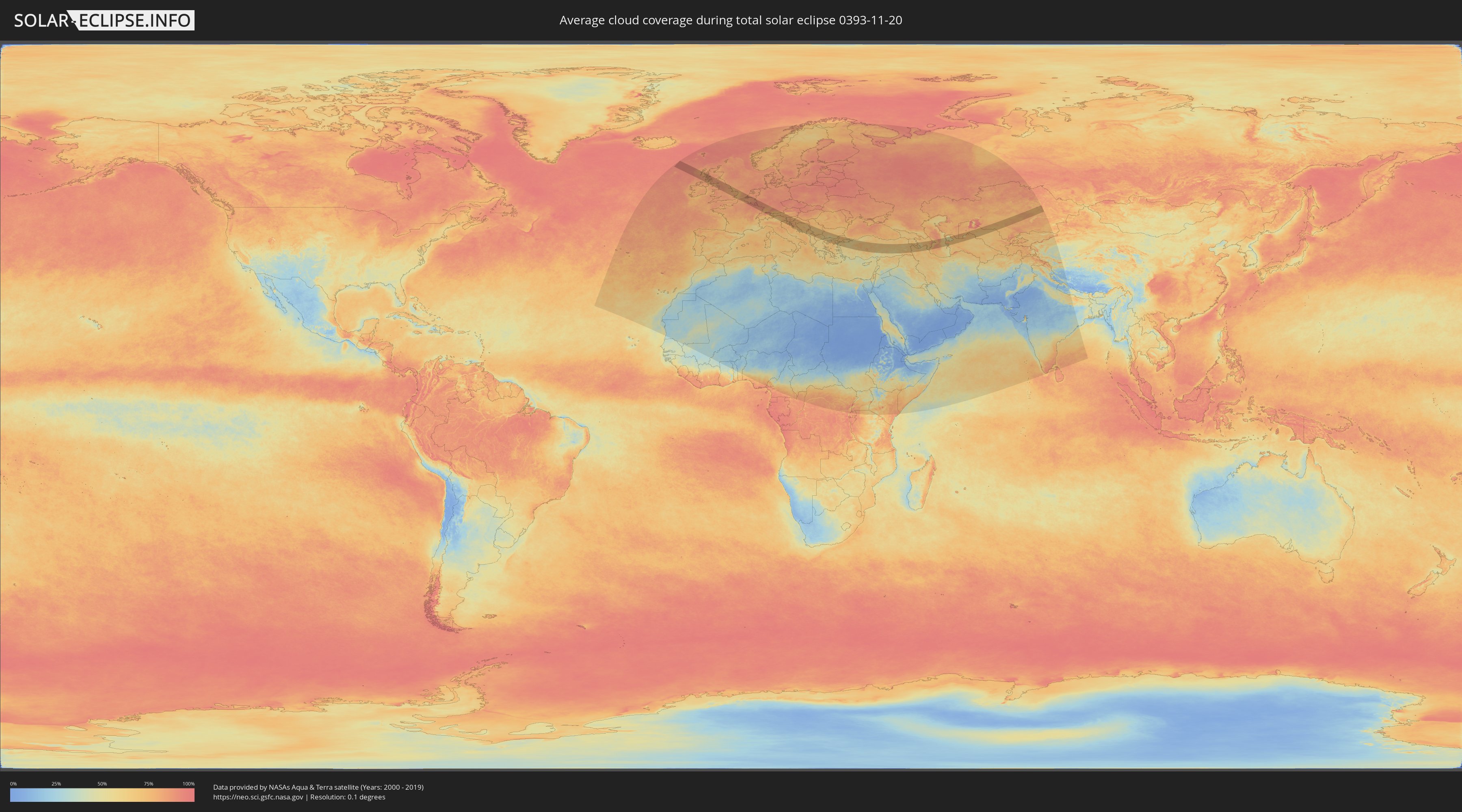
Wie wird das Wetter während der totalen Sonnenfinsternis am 20.11.0393?
Wo ist der beste Ort, um die totale Sonnenfinsternis vom 20.11.0393 zu beobachten?
Die folgenden Karten zeigen die durchschnittliche Bewölkung für den Tag, an dem die totale Sonnenfinsternis
stattfindet. Mit Hilfe der Karten lässt sich der Ort entlang des Finsternispfades eingrenzen,
der die besten Aussichen auf einen klaren wolkenfreien Himmel bietet.
Trotzdem muss man immer lokale Gegenenheiten beachten und sollte sich genau über das Wetter an seinem
gewählten Beobachtungsort informieren.
Die Daten stammen von den beiden NASA-Satelliten
AQUA und TERRA
und wurden über einen Zeitraum von 19 Jahren (2000 - 2019) gemittelt.

Detaillierte Länderkarten
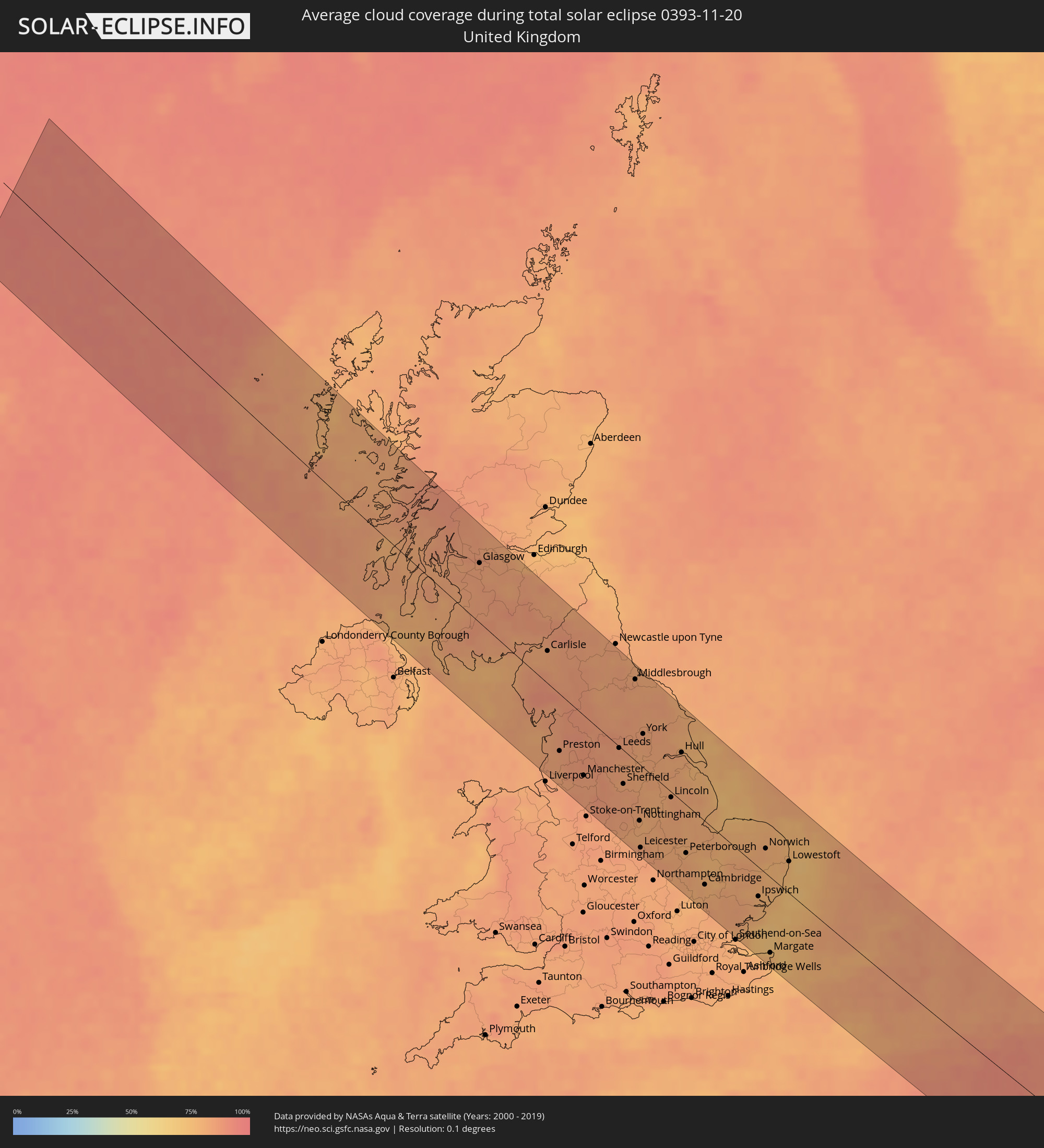 Vereinigtes Königreich
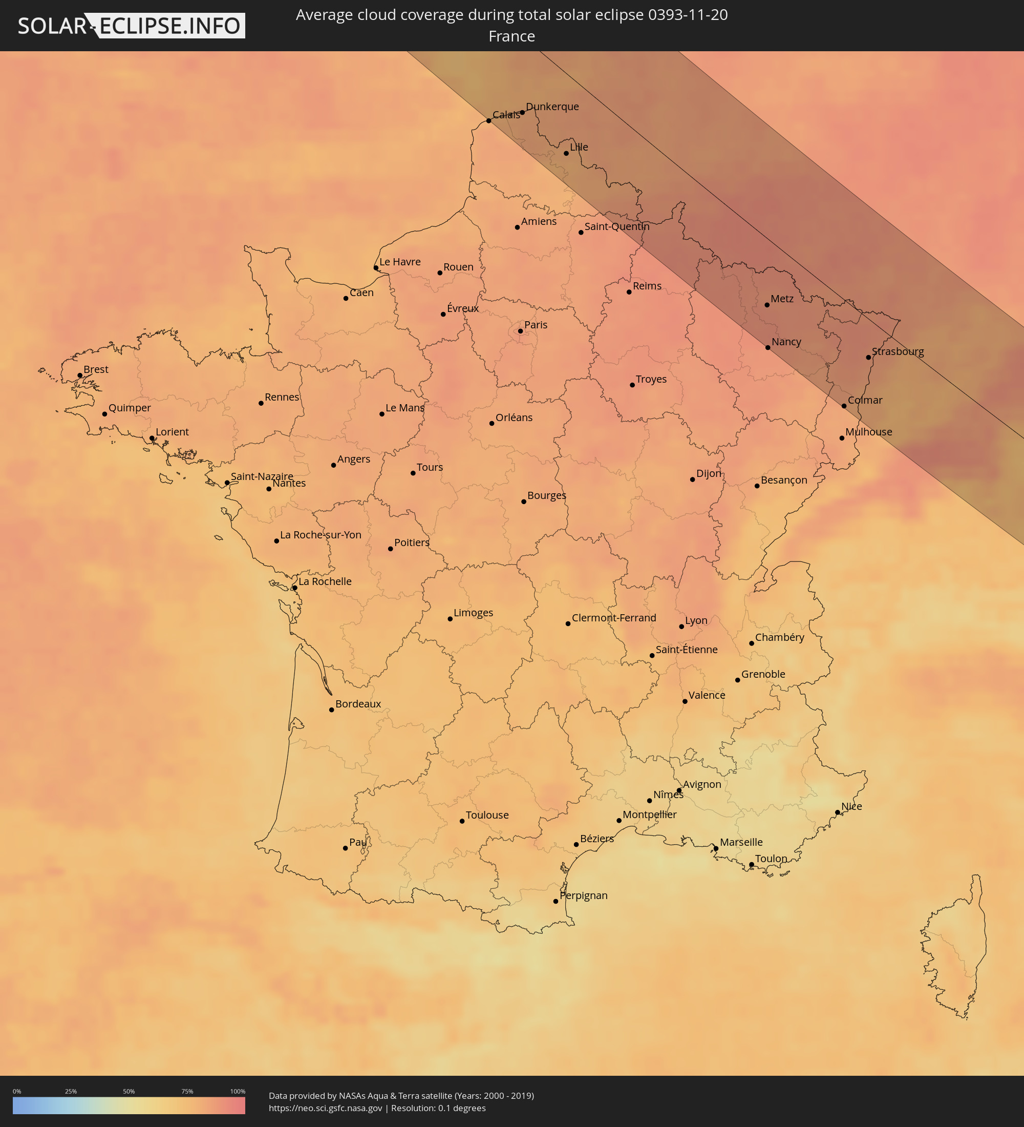 Frankreich
 Isle of Man
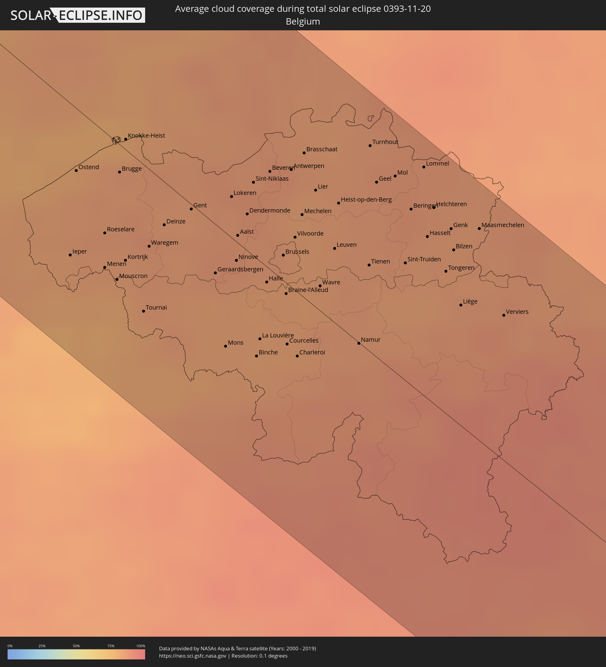 Belgien
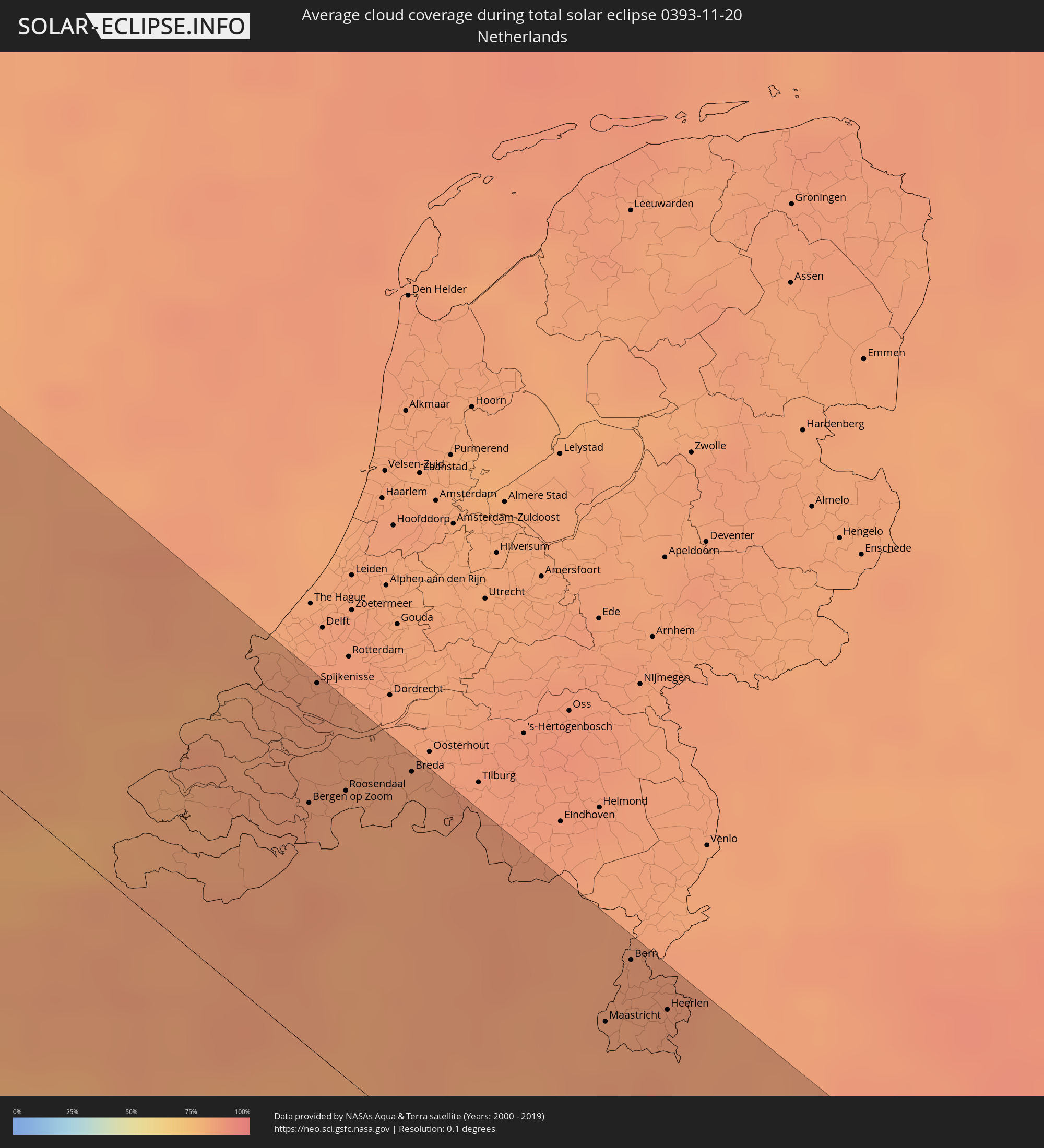 Niederlande
 Luxemburg
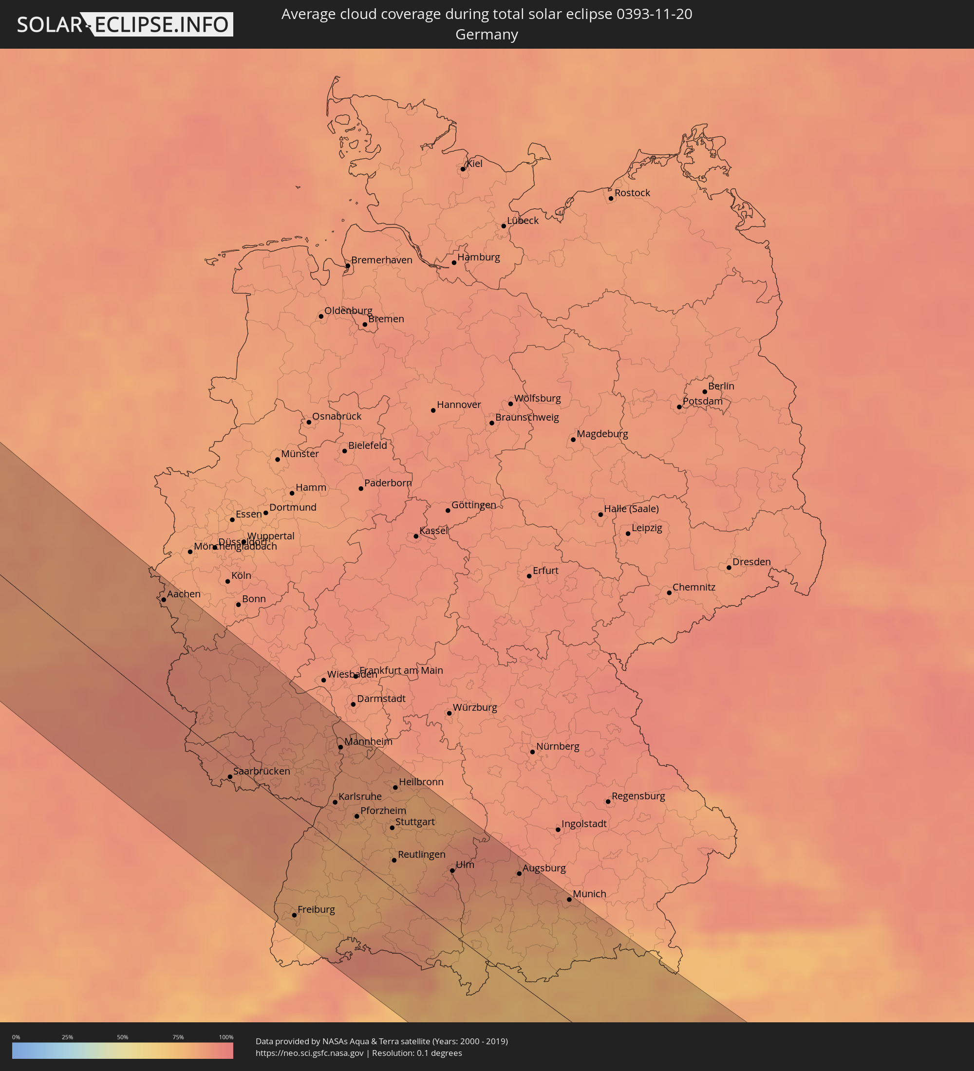 Deutschland
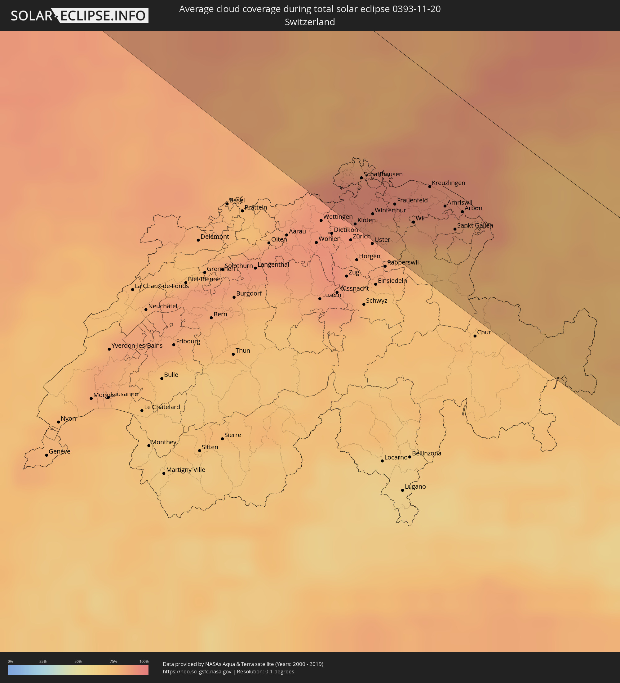 Schweiz
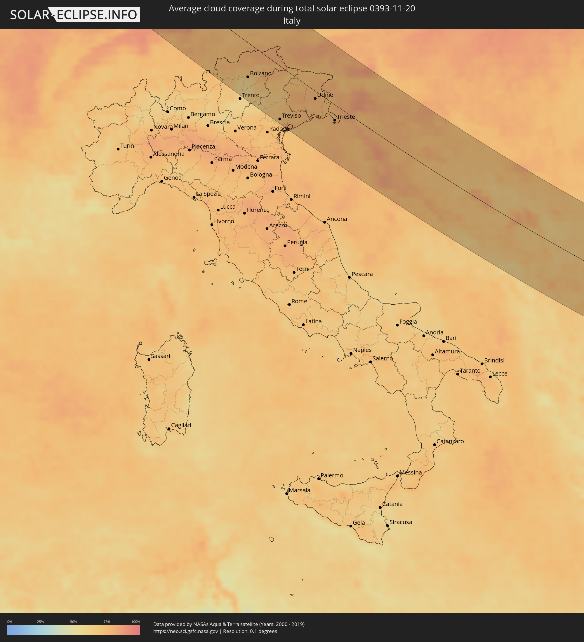 Italien
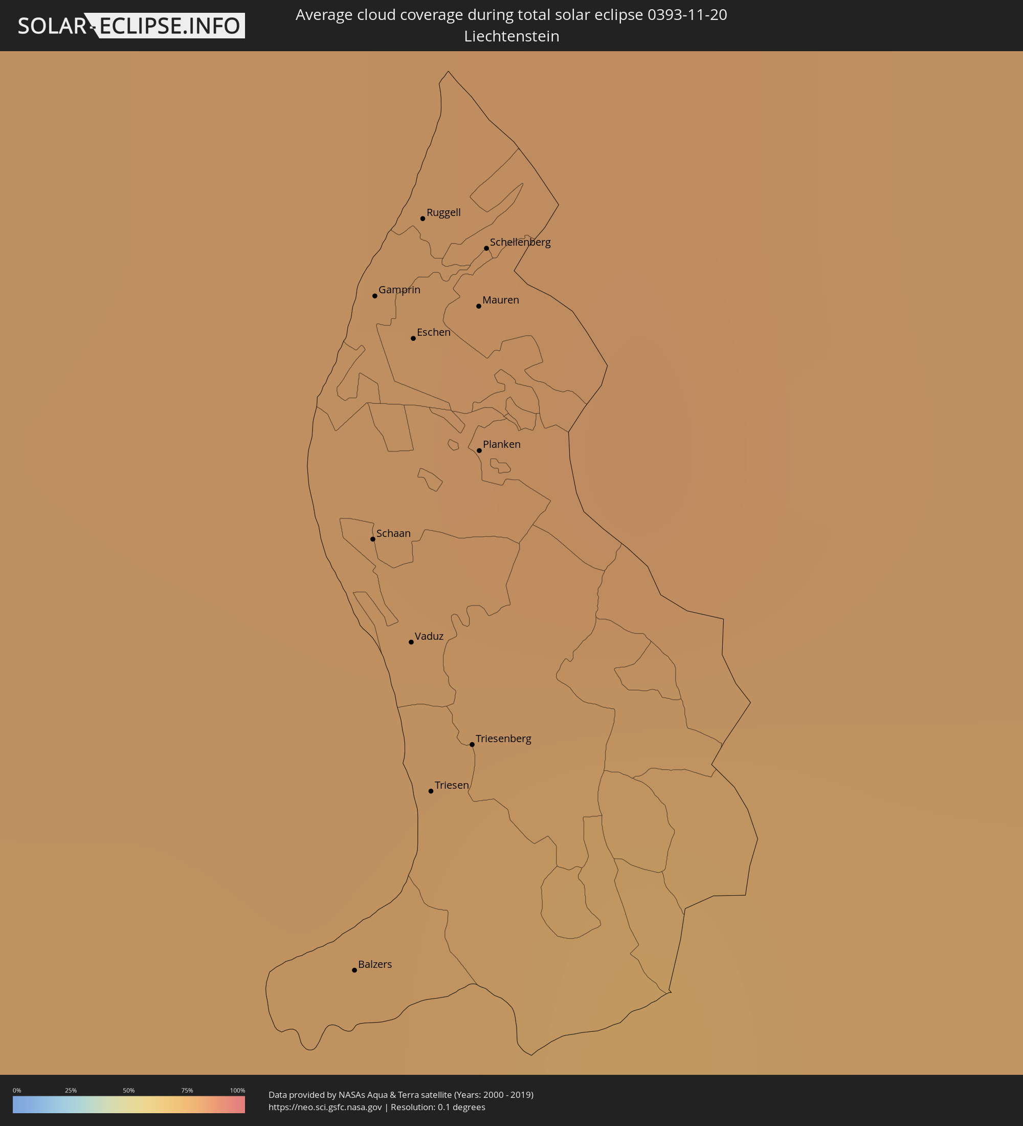 Liechtenstein
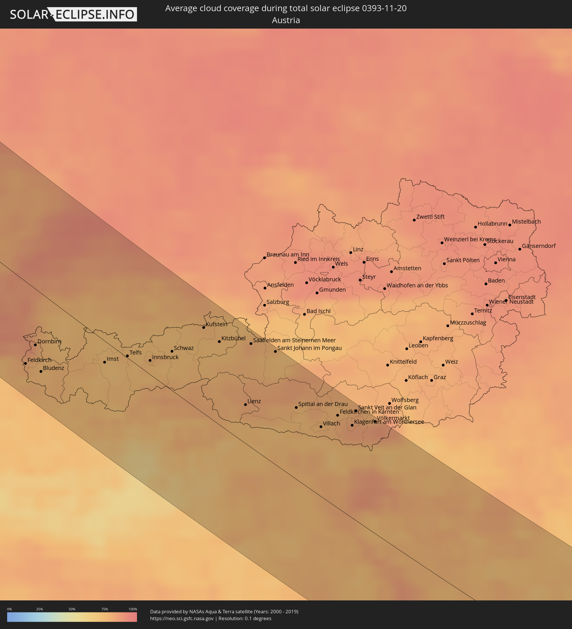 Österreich
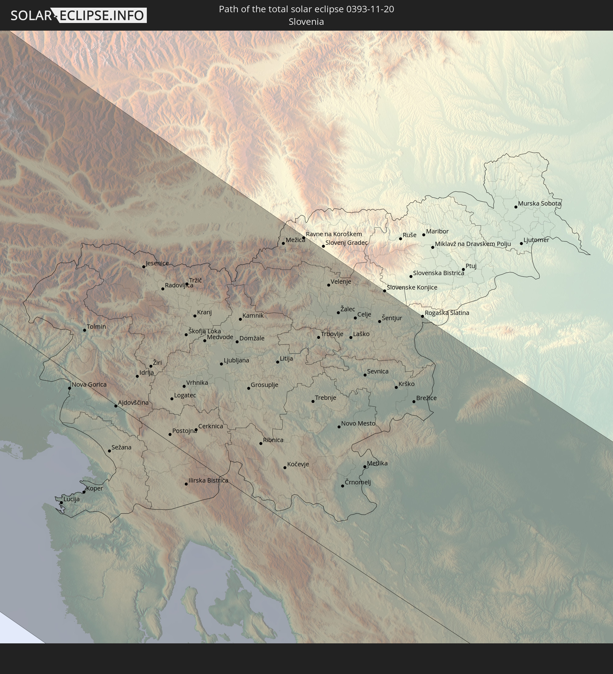
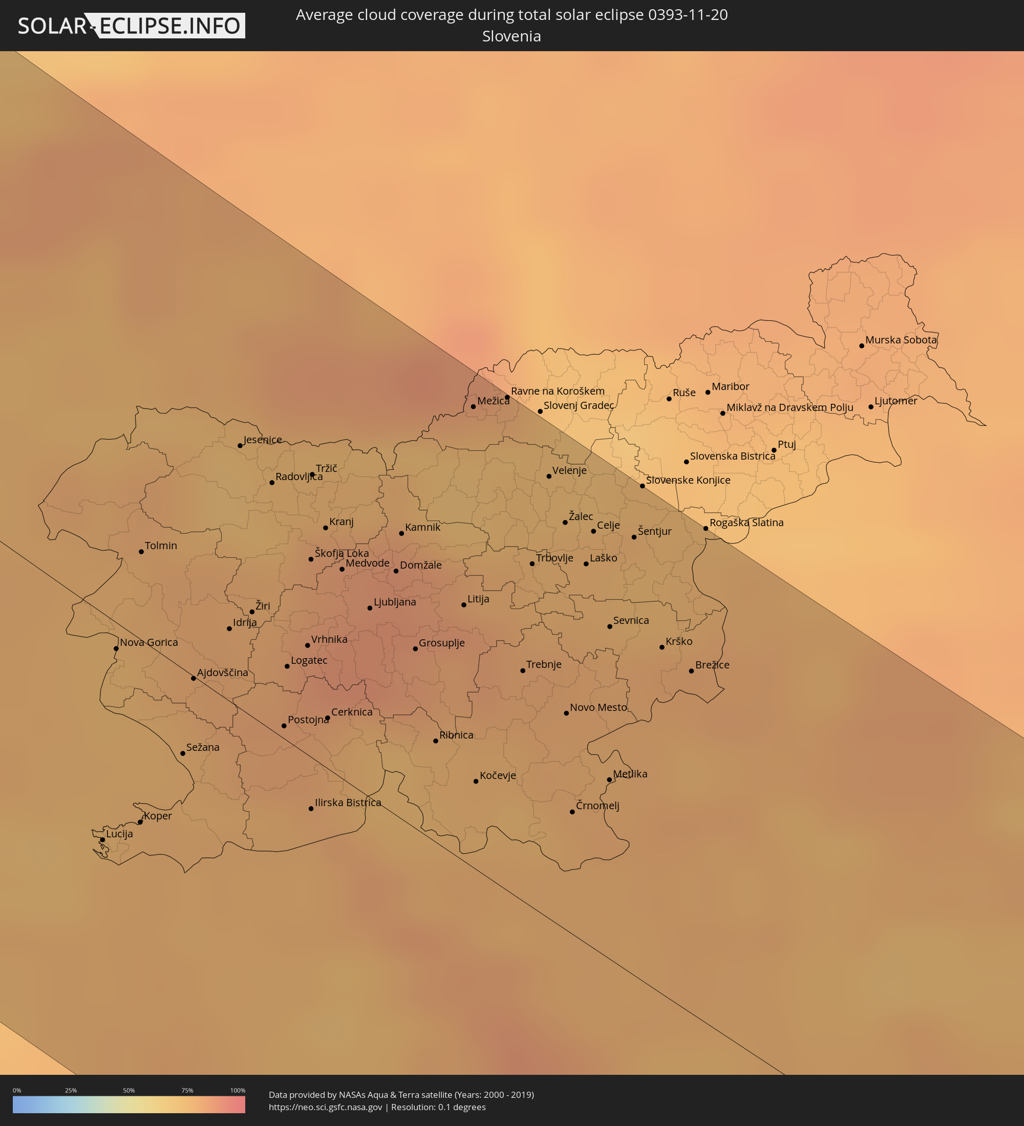 Slowenien
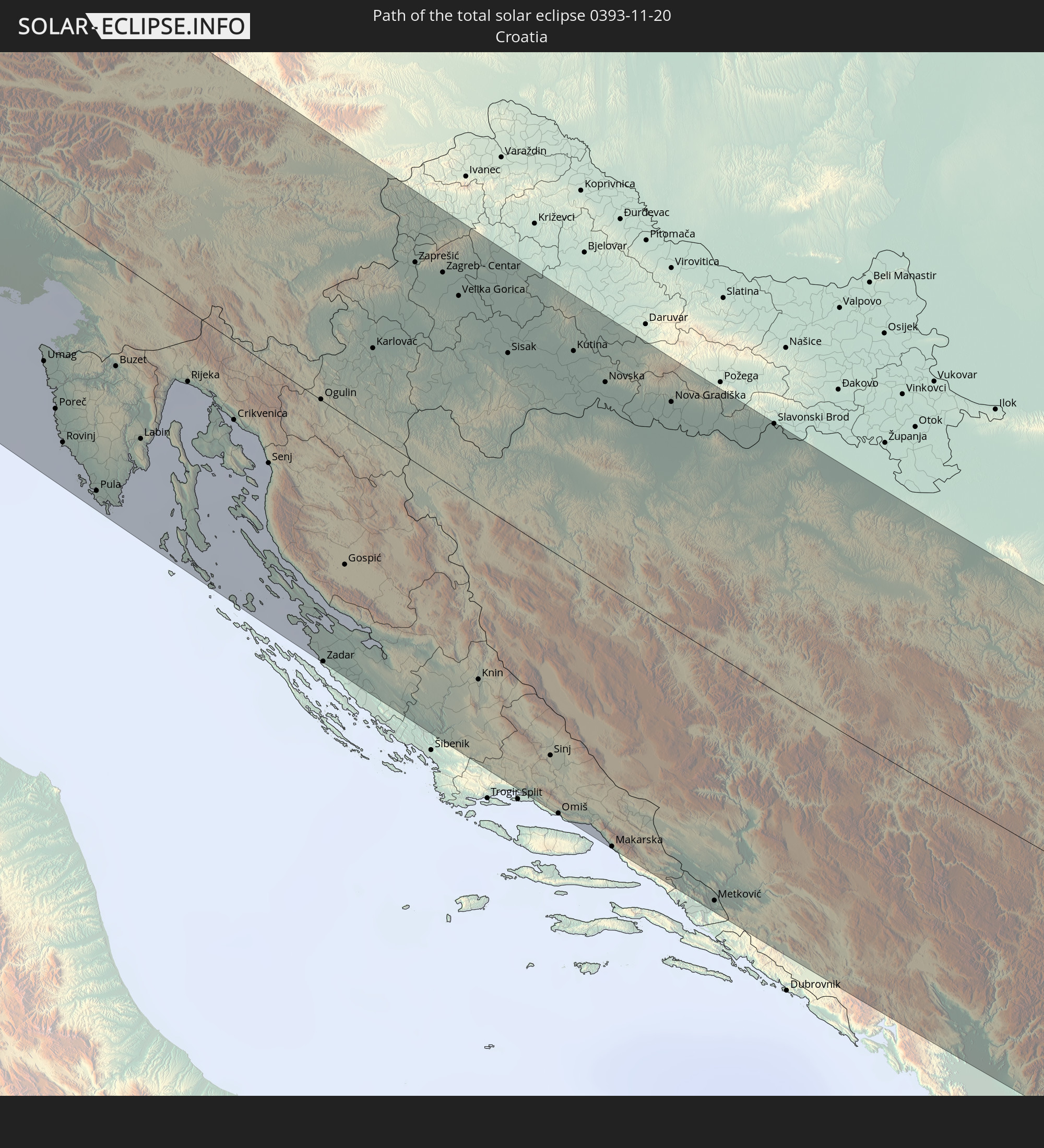
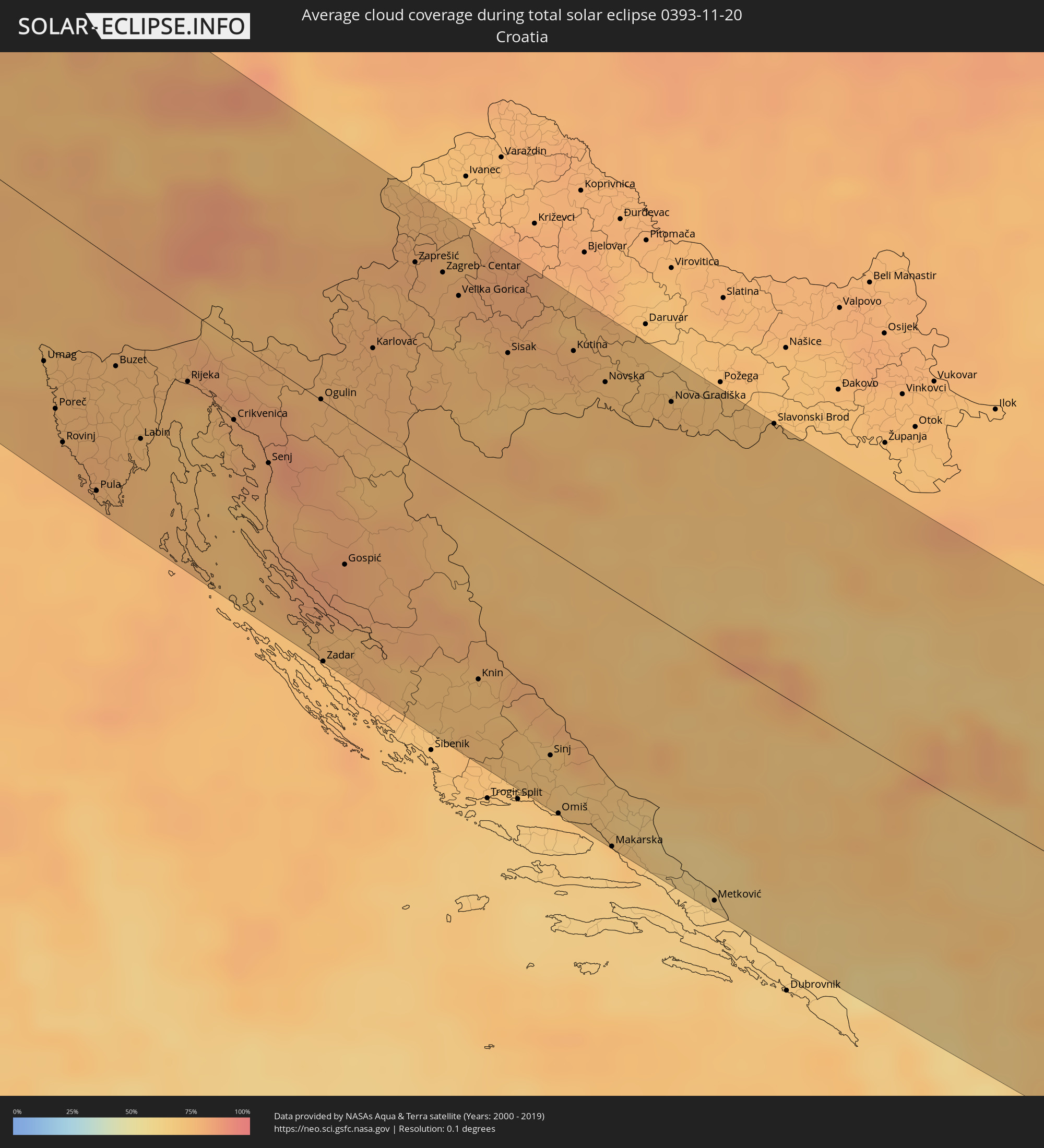 Kroatien
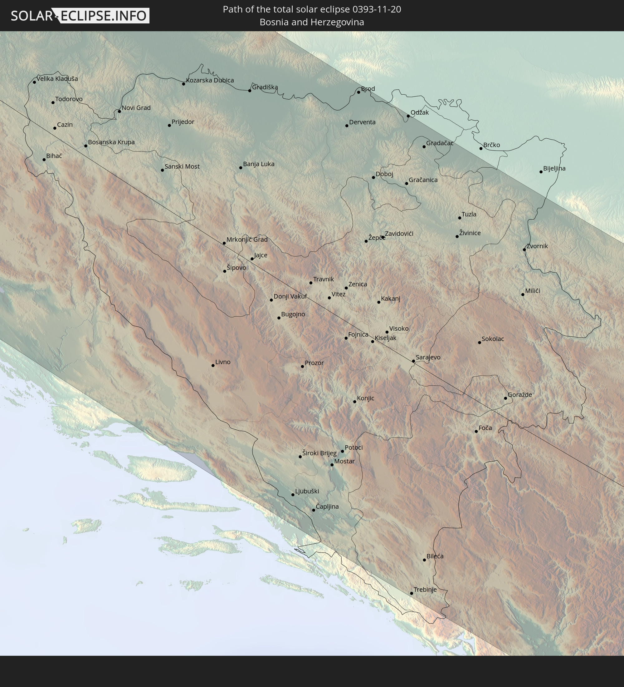
 Bosnien und Herzegowina
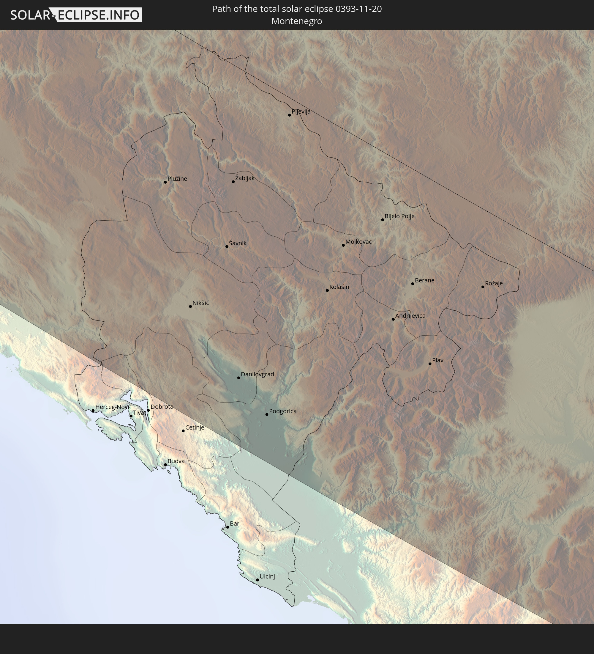
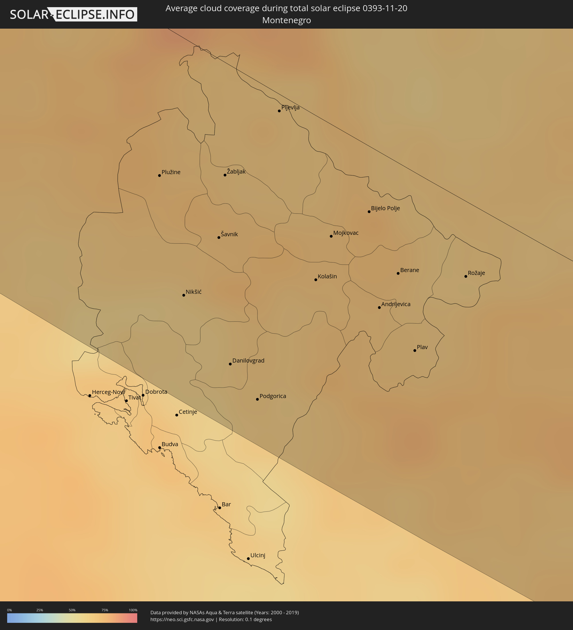 Montenegro
 Serbien
 Albanien
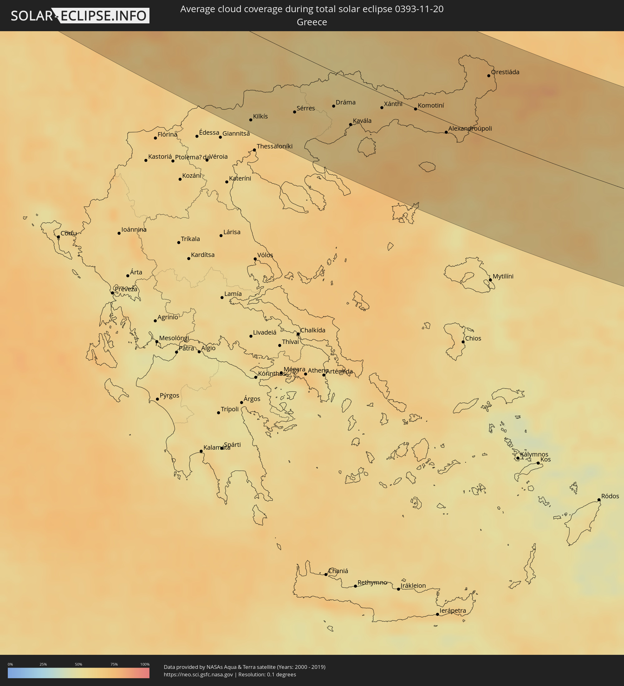 Griechenland
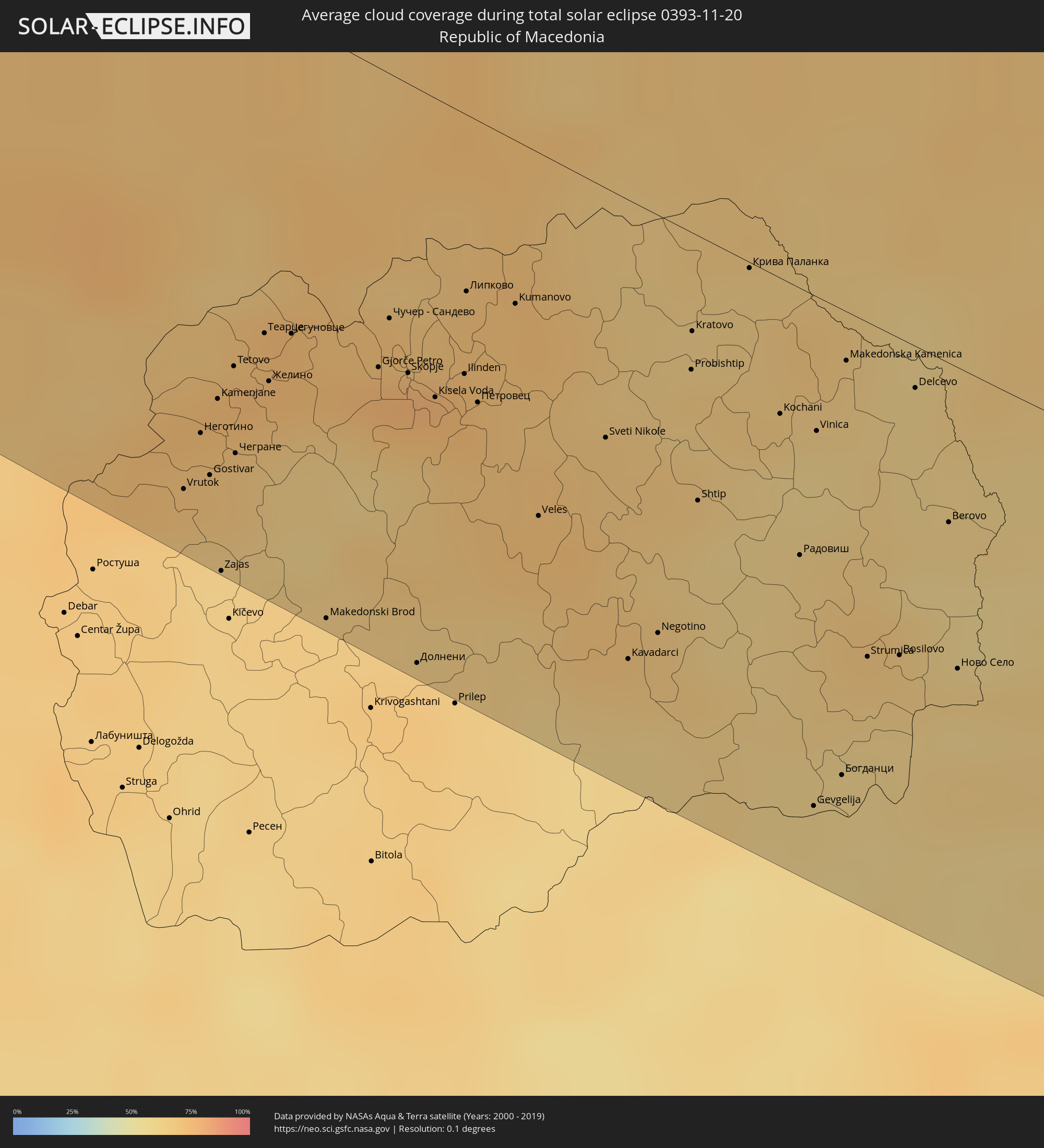 Mazedonien
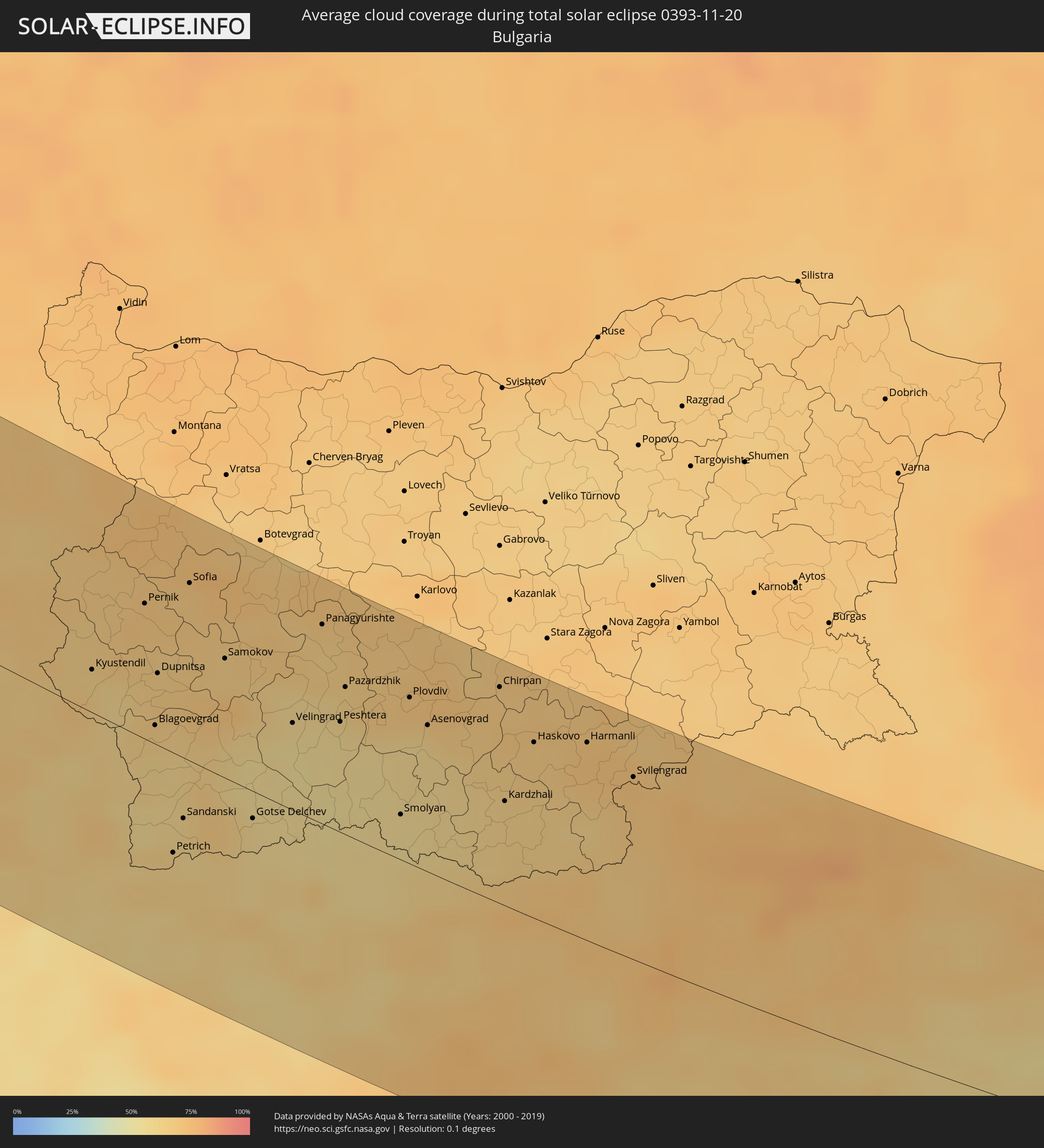 Bulgarien
 Türkei
 Armenien
 Iran
Iran
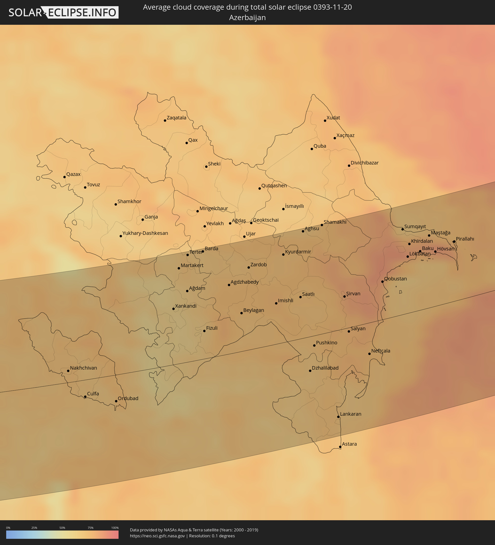 Aserbaidschan
 Kasachstan
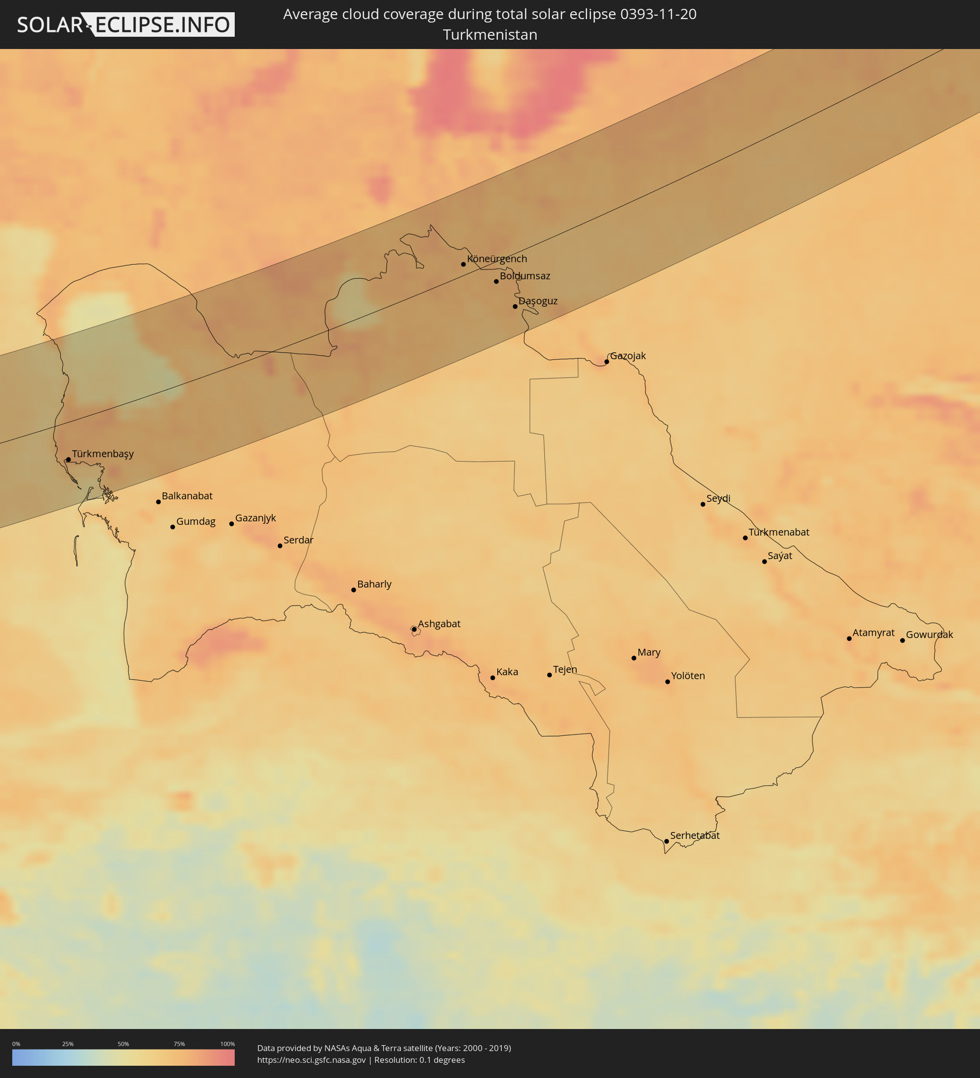 Turkmenistan
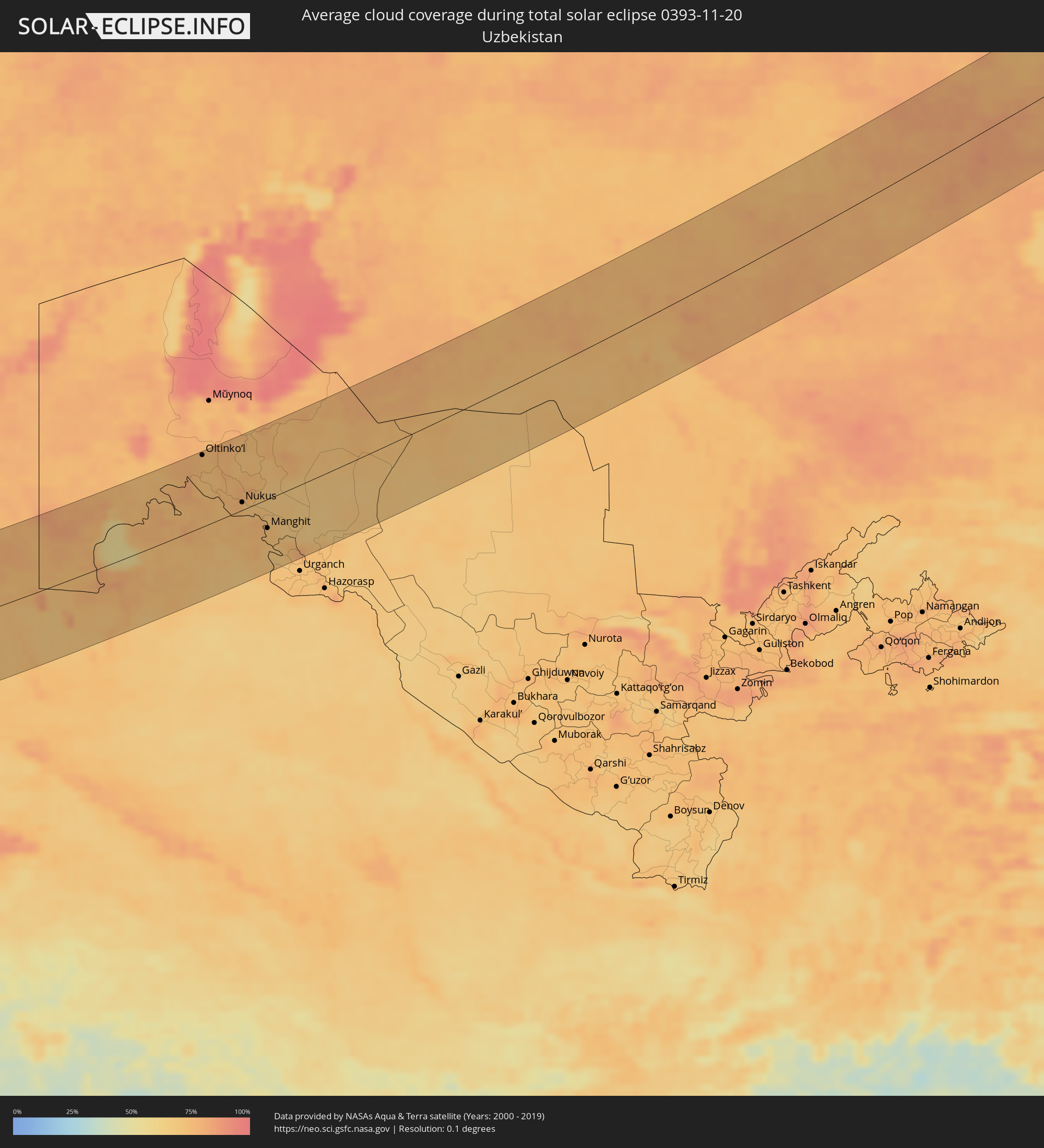 Usbekistan
Orte im Finsternispfad
Die nachfolgene Tabelle zeigt Städte und Orte mit mehr als 5.000 Einwohnern, die sich im Finsternispfad befinden. Städte mit mehr als 100.000 Einwohnern sind dick gekennzeichnet. Mit einem Klick auf den Ort öffnet sich eine Detailkarte die die Lage des jeweiligen Ortes zusammen mit dem Verlauf der zentralen Finsternis präsentiert.
| Ort | Typ | Dauer der Verfinsterung | Ortszeit bei maximaler Verfinsterung | Entfernung zur Zentrallinie | Ø Bewölkung |
|
Ballaugh, Ballaugh
|
total | - | 09:20:30 UTC+00:00 | 87 km | 82% |
|
Jurby, Jurby
|
total | - | 09:20:34 UTC+00:00 | 82 km | 80% |
|
Andreas, Andreas
|
total | - | 09:20:39 UTC+00:00 | 78 km | 79% |
|
Lezayre, Lezayre
|
total | - | 09:20:37 UTC+00:00 | 81 km | 80% |
|
Bride, Bride
|
total | - | 09:20:43 UTC+00:00 | 74 km | 79% |
|
Ramsey, Ramsey
|
total | - | 09:20:39 UTC+00:00 | 79 km | 80% |
|
Maughold, Maughold
|
total | - | 09:20:41 UTC+00:00 | 79 km | 80% |
|
Glasgow, Scotland
|
total | - | 09:22:19 UTC+00:00 | 54 km | 83% |
|
Manchester, England
|
total | - | 09:21:48 UTC+00:00 | 58 km | 84% |
|
Leeds, England
|
total | - | 09:22:45 UTC+00:00 | 1 km | 85% |
|
Derby, England
|
total | - | 09:22:01 UTC+00:00 | 72 km | 82% |
|
Sheffield, England
|
total | - | 09:22:27 UTC+00:00 | 33 km | 84% |
|
Nottingham, England
|
total | - | 09:22:22 UTC+00:00 | 55 km | 80% |
|
Leicester, England
|
total | - | 09:22:06 UTC+00:00 | 81 km | 84% |
|
Hull, England
|
total | - | 09:23:52 UTC+00:00 | 47 km | 81% |
|
Dunkerque, Hauts-de-France
|
total | - | 09:33:48 UTC+00:09 | 63 km | 82% |
|
Lille, Hauts-de-France
|
total | - | 09:34:16 UTC+00:09 | 67 km | 77% |
|
Douai, Hauts-de-France
|
total | - | 09:34:04 UTC+00:09 | 90 km | 78% |
|
Brugge, Flanders
|
total | - | 09:25:32 UTC+00:00 | 10 km | 84% |
|
Middelburg, Zeeland
|
total | - | 09:45:44 UTC+00:19 | 32 km | 83% |
|
Gent, Flanders
|
total | - | 09:25:59 UTC+00:00 | 2 km | 83% |
|
Goes, Zeeland
|
total | - | 09:46:03 UTC+00:19 | 45 km | 84% |
|
Spijkenisse, South Holland
|
total | - | 09:46:49 UTC+00:19 | 93 km | 86% |
|
Brussels, Brussels Capital
|
total | - | 09:26:34 UTC+00:00 | 9 km | 85% |
|
Antwerpen, Flanders
|
total | - | 09:26:54 UTC+00:00 | 43 km | 85% |
|
Charleroi, Wallonia
|
total | - | 09:26:22 UTC+00:00 | 24 km | 83% |
|
Roosendaal, North Brabant
|
total | - | 09:46:44 UTC+00:19 | 73 km | 83% |
|
Leuven, Flanders
|
total | - | 09:27:00 UTC+00:00 | 28 km | 83% |
|
Charleville-Mézières, Grand-Est
|
total | - | 09:35:35 UTC+00:09 | 68 km | 90% |
|
Breda, North Brabant
|
total | - | 09:47:08 UTC+00:19 | 91 km | 84% |
|
Namur, Wallonia
|
total | - | 09:26:54 UTC+00:00 | 0 km | 85% |
|
Liège, Wallonia
|
total | - | 09:27:52 UTC+00:00 | 45 km | 85% |
|
Maastricht, Limburg
|
total | - | 09:47:42 UTC+00:19 | 69 km | 83% |
|
Born, Limburg
|
total | - | 09:47:58 UTC+00:19 | 90 km | 85% |
|
Differdange, Luxembourg
|
total | - | 09:52:07 UTC+00:24 | 36 km | 89% |
|
Belvaux, Luxembourg
|
total | - | 09:52:09 UTC+00:24 | 35 km | 89% |
|
Esch-sur-Alzette, Luxembourg
|
total | - | 09:52:12 UTC+00:24 | 34 km | 89% |
|
Heerlen, Limburg
|
total | - | 09:48:04 UTC+00:19 | 85 km | 86% |
|
Bertrange, Luxembourg
|
total | - | 09:52:22 UTC+00:24 | 21 km | 90% |
|
Strassen, Luxembourg
|
total | - | 09:52:24 UTC+00:24 | 19 km | 90% |
|
Aachen, North Rhine-Westphalia
|
total | - | 10:28:35 UTC+01:00 | 81 km | 84% |
|
Ettelbruck, Diekirch
|
total | - | 09:52:36 UTC+00:24 | 2 km | 91% |
|
Luxembourg, Luxembourg
|
total | - | 09:52:28 UTC+00:24 | 18 km | 90% |
|
Diekirch, Diekirch
|
total | - | 09:52:40 UTC+00:24 | 6 km | 91% |
|
Metz, Grand-Est
|
total | - | 09:36:57 UTC+00:09 | 59 km | 89% |
|
Nancy, Grand-Est
|
total | - | 09:36:41 UTC+00:09 | 96 km | 87% |
|
Saarbrücken, Saarland
|
total | - | 10:28:43 UTC+01:00 | 12 km | 87% |
|
Colmar, Grand-Est
|
total | - | 09:37:52 UTC+00:09 | 96 km | 81% |
|
Strasbourg, Grand-Est
|
total | - | 09:38:40 UTC+00:09 | 35 km | 86% |
|
Freiburg, Baden-Württemberg
|
total | - | 10:29:07 UTC+01:00 | 82 km | 77% |
|
Karlsruhe, Baden-Württemberg
|
total | - | 10:30:26 UTC+01:00 | 32 km | 85% |
|
Mannheim, Baden-Württemberg
|
total | - | 10:30:49 UTC+01:00 | 78 km | 87% |
|
Schaffhausen, Schaffhausen
|
total | - | 10:30:01 UTC+01:00 | 73 km | 90% |
|
Winterthur, Zurich
|
total | - | 10:30:02 UTC+01:00 | 86 km | 87% |
|
Wetzikon, Zurich
|
total | - | 10:30:02 UTC+01:00 | 99 km | 83% |
|
Wil, Saint Gallen
|
total | - | 10:30:27 UTC+01:00 | 76 km | 83% |
|
Kreuzlingen, Thurgau
|
total | - | 10:30:44 UTC+01:00 | 53 km | 89% |
|
Stuttgart, Baden-Württemberg
|
total | - | 10:31:21 UTC+01:00 | 47 km | 78% |
|
Sankt Gallen, Saint Gallen
|
total | - | 10:30:53 UTC+01:00 | 64 km | 77% |
|
Buchs, Saint Gallen
|
total | - | 10:30:54 UTC+01:00 | 82 km | 76% |
|
Schaan, Schaan
|
total | - | 10:30:57 UTC+01:00 | 81 km | 76% |
|
Gamprin, Gamprin
|
total | - | 10:30:59 UTC+01:00 | 76 km | 76% |
|
Eschen, Eschen
|
total | - | 10:30:59 UTC+01:00 | 77 km | 76% |
|
Ruggell, Ruggell
|
total | - | 10:31:00 UTC+01:00 | 74 km | 76% |
|
Triesenberg, Triesenberg
|
total | - | 10:30:58 UTC+01:00 | 84 km | 76% |
|
Mauren, Mauren
|
total | - | 10:31:01 UTC+01:00 | 75 km | 76% |
|
Planken, Planken
|
total | - | 10:31:00 UTC+01:00 | 78 km | 76% |
|
Schellenberg, Schellenberg
|
total | - | 10:31:02 UTC+01:00 | 74 km | 76% |
|
Feldkirch, Vorarlberg
|
total | - | 10:31:07 UTC+01:00 | 71 km | 73% |
|
Dornbirn, Vorarlberg
|
total | - | 10:31:24 UTC+01:00 | 48 km | 79% |
|
Davos, Grisons
|
total | - | 10:31:14 UTC+01:00 | 99 km | 73% |
|
Augsburg, Bavaria
|
total | - | 10:33:31 UTC+01:00 | 89 km | 86% |
|
Merano, Trentino-Alto Adige
|
total | - | 10:33:06 UTC+01:00 | 52 km | 70% |
|
Bolzano, Trentino-Alto Adige
|
total | - | 10:33:17 UTC+01:00 | 60 km | 62% |
|
Innsbruck, Tyrol
|
total | - | 10:33:43 UTC+01:00 | 12 km | 74% |
|
Munich, Bavaria
|
total | - | 10:34:23 UTC+01:00 | 98 km | 79% |
|
Kufstein, Tyrol
|
total | - | 10:34:59 UTC+01:00 | 76 km | 74% |
|
Treviso, Veneto
|
total | - | 10:34:18 UTC+01:00 | 94 km | 71% |
|
San Donà di Piave, Veneto
|
total | - | 10:34:48 UTC+01:00 | 83 km | 77% |
|
Pordenone, Friuli Venezia Giulia
|
total | - | 10:35:04 UTC+01:00 | 49 km | 75% |
|
Saalfelden am Steinernen Meer, Salzburg
|
total | - | 10:35:56 UTC+01:00 | 92 km | 77% |
|
Udine, Friuli Venezia Giulia
|
total | - | 10:36:00 UTC+01:00 | 13 km | 76% |
|
Spittal an der Drau, Carinthia
|
total | - | 10:36:41 UTC+01:00 | 65 km | 74% |
|
Gorizia, Friuli Venezia Giulia
|
total | - | 10:36:33 UTC+01:00 | 8 km | 73% |
|
Koper, Koper-Capodistria
|
total | - | 10:36:35 UTC+01:00 | 40 km | 76% |
|
Trieste, Friuli Venezia Giulia
|
total | - | 10:36:43 UTC+01:00 | 28 km | 77% |
|
Pula, Istarska
|
total | - | 10:36:32 UTC+01:00 | 97 km | 76% |
|
Villach, Carinthia
|
total | - | 10:37:09 UTC+01:00 | 63 km | 73% |
|
Klagenfurt am Wörthersee, Carinthia
|
total | - | 10:37:52 UTC+01:00 | 84 km | 79% |
|
Kranj, Kranj
|
total | - | 10:37:48 UTC+01:00 | 51 km | 83% |
|
Rijeka, Primorsko-Goranska
|
total | - | 10:37:36 UTC+01:00 | 28 km | 73% |
|
Ljubljana, Ljubljana
|
total | - | 10:37:59 UTC+01:00 | 41 km | 86% |
|
Kamnik, Kamnik
|
total | - | 10:38:12 UTC+01:00 | 62 km | 86% |
|
Trbovlje, Trbovlje
|
total | - | 10:38:53 UTC+01:00 | 74 km | 75% |
|
Velenje, Velenje
|
total | - | 10:39:02 UTC+01:00 | 96 km | 73% |
|
Novo Mesto, Novo Mesto
|
total | - | 10:38:58 UTC+01:00 | 47 km | 78% |
|
Zadar, Zadarska
|
total | - | 10:38:36 UTC+01:00 | 106 km | 73% |
|
Celje, Celje
|
total | - | 10:39:14 UTC+01:00 | 90 km | 75% |
|
Karlovac, Karlovačka
|
total | - | 10:39:29 UTC+01:00 | 35 km | 78% |
|
Bihać, Federation of Bosnia and Herzegovina
|
total | - | 10:39:50 UTC+01:00 | 14 km | 75% |
|
Zagreb - Centar, City of Zagreb
|
total | - | 10:40:17 UTC+01:00 | 83 km | 78% |
|
Sisak, Sisačko-Moslavačka
|
total | - | 10:40:51 UTC+01:00 | 69 km | 77% |
|
Solin, Splitsko-Dalmatinska
|
total | - | 10:40:35 UTC+01:00 | 107 km | 67% |
|
Prijedor, Republic of Srspka
|
total | - | 10:41:17 UTC+01:00 | 38 km | 79% |
|
Banja Luka, Republic of Srspka
|
total | - | 10:42:03 UTC+01:00 | 40 km | 71% |
|
Bugojno, Federation of Bosnia and Herzegovina
|
total | - | 10:42:21 UTC+01:00 | 17 km | 73% |
|
Mostar, Federation of Bosnia and Herzegovina
|
total | - | 10:42:51 UTC+01:00 | 70 km | 64% |
|
Zenica, Federation of Bosnia and Herzegovina
|
total | - | 10:43:09 UTC+01:00 | 15 km | 81% |
|
Slavonski Brod, Slavonski Brod-Posavina
|
total | - | 10:43:31 UTC+01:00 | 110 km | 73% |
|
Sarajevo, Federation of Bosnia and Herzegovina
|
total | - | 10:43:53 UTC+01:00 | 1 km | 68% |
|
Tuzla, Federation of Bosnia and Herzegovina
|
total | - | 10:44:32 UTC+01:00 | 79 km | 74% |
|
Nikšić, Opština Nikšić
|
total | - | 10:44:48 UTC+01:00 | 78 km | 62% |
|
Danilovgrad, Danilovgrad
|
total | - | 10:45:09 UTC+01:00 | 91 km | 63% |
|
Podgorica, Podgorica
|
total | - | 10:45:21 UTC+01:00 | 97 km | 65% |
|
Pljevlja, Pljevlja
|
total | - | 10:45:37 UTC+01:00 | 5 km | 67% |
|
Mojkovac, Mojkovac
|
total | - | 10:45:59 UTC+01:00 | 34 km | 70% |
|
Bijelo Polje, Bijelo Polje
|
total | - | 10:46:17 UTC+01:00 | 20 km | 71% |
|
Užice, Central Serbia
|
total | - | 10:46:32 UTC+01:00 | 63 km | 68% |
|
Berane, Berane
|
total | - | 10:46:30 UTC+01:00 | 34 km | 67% |
|
Valjevo, Central Serbia
|
total | - | 10:46:40 UTC+01:00 | 105 km | 72% |
|
Pukë, Shkodër
|
total | - | 11:05:50 UTC+01:19 | 111 km | 67% |
|
Rožaje, Opština Rožaje
|
total | - | 10:47:02 UTC+01:00 | 23 km | 69% |
|
Čačak, Central Serbia
|
total | - | 10:47:27 UTC+01:00 | 86 km | 71% |
|
Kukës, Kukës
|
total | - | 11:06:48 UTC+01:19 | 87 km | 68% |
|
Novi Pazar, Central Serbia
|
total | - | 10:47:41 UTC+01:00 | 20 km | 66% |
|
Kraljevo, Central Serbia
|
total | - | 10:48:03 UTC+01:00 | 84 km | 66% |
|
Gostivar, Gostivar
|
total | - | 10:48:22 UTC+01:00 | 96 km | 65% |
|
Tetovo, Tetovo
|
total | - | 10:48:30 UTC+01:00 | 72 km | 71% |
|
Kruševac, Central Serbia
|
total | - | 10:49:13 UTC+01:00 | 96 km | 68% |
|
Skopje, Karpoš
|
total | - | 10:49:22 UTC+01:00 | 56 km | 73% |
|
Kumanovo, Kumanovo
|
total | - | 10:49:54 UTC+01:00 | 31 km | 70% |
|
Veles, Veles
|
total | - | 10:50:01 UTC+01:00 | 70 km | 70% |
|
Niš, Central Serbia
|
total | - | 10:50:15 UTC+01:00 | 93 km | 67% |
|
Leskovac, Central Serbia
|
total | - | 10:50:20 UTC+01:00 | 63 km | 67% |
|
Kavadarci, Kavadarci
|
total | - | 10:50:29 UTC+01:00 | 89 km | 62% |
|
Shtip, Štip
|
total | - | 10:50:50 UTC+01:00 | 51 km | 63% |
|
Strumica, Strumica
|
total | - | 10:51:42 UTC+01:00 | 66 km | 63% |
|
Kilkís, Central Macedonia
|
total | - | 11:27:03 UTC+01:34 | 102 km | 59% |
|
Pernik, Pernik
|
total | - | 11:52:24 UTC+02:00 | 65 km | 68% |
|
Blagoevgrad, Blagoevgrad
|
total | - | 11:52:33 UTC+02:00 | 9 km | 63% |
|
Sofia, Sofia-Capital
|
total | - | 11:52:56 UTC+02:00 | 85 km | 68% |
|
Sérres, Central Macedonia
|
total | - | 11:28:22 UTC+01:34 | 68 km | 64% |
|
Dráma, East Macedonia and Thrace
|
total | - | 11:29:32 UTC+01:34 | 40 km | 60% |
|
Pazardzhik, Pazardzhik
|
total | - | 11:54:55 UTC+02:00 | 72 km | 63% |
|
Kavála, East Macedonia and Thrace
|
total | - | 11:30:05 UTC+01:34 | 53 km | 60% |
|
Plovdiv, Plovdiv
|
total | - | 11:55:44 UTC+02:00 | 81 km | 69% |
|
Asenovgrad, Plovdiv
|
total | - | 11:55:59 UTC+02:00 | 72 km | 63% |
|
Xánthi, East Macedonia and Thrace
|
total | - | 11:31:00 UTC+01:34 | 17 km | 66% |
|
Kardzhali, Kŭrdzhali
|
total | - | 11:57:01 UTC+02:00 | 52 km | 64% |
|
Komotiní, East Macedonia and Thrace
|
total | - | 11:32:02 UTC+01:34 | 1 km | 68% |
|
Haskovo, Khaskovo
|
total | - | 11:57:20 UTC+02:00 | 87 km | 66% |
|
Alexandroúpoli, East Macedonia and Thrace
|
total | - | 11:33:02 UTC+01:34 | 13 km | 66% |
|
Orestiáda, East Macedonia and Thrace
|
total | - | 11:34:12 UTC+01:34 | 75 km | 71% |
|
İstanbul, Istanbul
|
total | - | 12:01:16 UTC+01:56 | 96 km | 69% |
|
Bursa, Bursa
|
total | - | 12:01:45 UTC+01:56 | 12 km | 61% |
|
Maltepe, Istanbul
|
total | - | 12:01:42 UTC+01:56 | 93 km | 66% |
|
Eskişehir, Eskişehir
|
total | - | 12:04:55 UTC+01:56 | 4 km | 73% |
|
Ankara, Ankara
|
total | - | 12:09:42 UTC+01:56 | 67 km | 66% |
|
Kayseri, Kayseri
|
total | - | 12:15:47 UTC+01:56 | 25 km | 63% |
|
Malatya, Malatya
|
total | - | 12:21:53 UTC+01:56 | 47 km | 68% |
|
Diyarbakır, Diyarbakır
|
total | - | 12:26:04 UTC+01:56 | 94 km | 57% |
|
Masis, Ararat Province
|
total | - | 13:33:29 UTC+02:58 | 119 km | 67% |
|
Artashat, Ararat Province
|
total | - | 13:33:49 UTC+02:58 | 106 km | 67% |
|
Ararat, Ararat Province
|
total | - | 13:34:13 UTC+02:58 | 90 km | 71% |
|
Salmās, Āz̄ārbāyjān-e Gharbī
|
total | - | 14:03:30 UTC+03:25 | 91 km | 64% |
|
Khvoy, Āz̄ārbāyjān-e Gharbī
|
total | - | 14:03:32 UTC+03:25 | 54 km | 66% |
|
Qarah Ẕīā’ od Dīn, Āz̄ārbāyjān-e Gharbī
|
total | - | 14:03:22 UTC+03:25 | 18 km | 67% |
|
Martuni, Gegharkunik Province
|
total | - | 13:35:02 UTC+02:58 | 116 km | 65% |
|
Nakhchivan, Nakhichevan
|
total | - | 13:57:28 UTC+03:19 | 12 km | 72% |
|
Vardenis, Gegharkunik Province
|
total | - | 13:35:46 UTC+02:58 | 115 km | 60% |
|
Marand, East Azerbaijan
|
total | - | 14:05:09 UTC+03:25 | 78 km | 72% |
|
Hats’avan, Syunik Province
|
total | - | 13:36:51 UTC+02:58 | 33 km | 64% |
|
Goris, Syunik Province
|
total | - | 13:37:27 UTC+02:58 | 33 km | 62% |
|
Qafan, Syunik Province
|
total | - | 13:37:52 UTC+02:58 | 2 km | 58% |
|
Xankandi, Xankǝndi
|
total | - | 13:59:19 UTC+03:19 | 60 km | 59% |
|
Ahar, East Azerbaijan
|
total | - | 14:07:27 UTC+03:25 | 92 km | 67% |
|
Pārsābād, Ardabīl
|
total | - | 14:07:50 UTC+03:25 | 21 km | 70% |
|
Saatlı, Saatlı
|
total | - | 14:02:00 UTC+03:19 | 44 km | 71% |
|
Lankaran, Lənkəran
|
total | - | 14:03:58 UTC+03:19 | 93 km | 67% |
|
Şirvan, Shirvan
|
total | - | 14:02:56 UTC+03:19 | 34 km | 76% |
|
Sumqayıt, Sumqayit
|
total | - | 14:03:31 UTC+03:19 | 89 km | 75% |
|
Baku, Baki
|
total | - | 14:04:06 UTC+03:19 | 61 km | 76% |
|
Maştağa, Baki
|
total | - | 14:04:08 UTC+03:19 | 75 km | 83% |
|
Türkmenbaşy, Balkan
|
total | - | 14:43:26 UTC+03:53 | 49 km | 68% |
|
Oltinko’l, Karakalpakstan
|
total | - | 15:22:30 UTC+04:27 | 96 km | 76% |
|
Köneürgench, Daşoguz
|
total | - | 14:49:21 UTC+03:53 | 12 km | 73% |
|
Akdepe
|
total | - | 14:49:58 UTC+03:53 | 23 km | 74% |
|
Khŭjayli, Karakalpakstan
|
total | - | 15:24:00 UTC+04:27 | 10 km | 75% |
|
Kegeyli Shahar, Karakalpakstan
|
total | - | 15:23:43 UTC+04:27 | 43 km | 75% |
|
Nukus, Karakalpakstan
|
total | - | 15:24:07 UTC+04:27 | 10 km | 76% |
|
Yylanly, Daşoguz
|
total | - | 14:50:34 UTC+03:53 | 54 km | 71% |
|
Boldumsaz, Daşoguz
|
total | - | 14:50:14 UTC+03:53 | 25 km | 73% |
|
Tagta, Daşoguz
|
total | - | 14:51:06 UTC+03:53 | 82 km | 73% |
|
Daşoguz, Daşoguz
|
total | - | 14:50:57 UTC+03:53 | 64 km | 71% |
|
Manghit, Karakalpakstan
|
total | - | 15:25:04 UTC+04:27 | 39 km | 73% |
|
Showot, Xorazm
|
total | - | 15:25:55 UTC+04:27 | 94 km | 69% |
|
Gurlan, Xorazm
|
total | - | 15:25:48 UTC+04:27 | 77 km | 69% |
|
Terenozek, Qyzylorda
|
total | - | 15:20:45 UTC+04:21 | 87 km | 76% |
|
Kyzyl-Orda, Qyzylorda
|
total | - | 15:21:32 UTC+04:21 | 49 km | 78% |
|
Kyzylorda, Qyzylorda
|
total | - | 15:21:32 UTC+04:21 | 49 km | 78% |
|
Tasböget, Qyzylorda
|
total | - | 15:21:40 UTC+04:21 | 40 km | 78% |
|
Shīeli, Qyzylorda
|
total | - | 15:23:36 UTC+04:21 | 63 km | 75% |
|
Aktau, Qaraghandy
|
total | - | 15:23:19 UTC+04:21 | 85 km | 79% |