Totale Sonnenfinsternis vom 16.04.0413
| Wochentag: | Dienstag |
| Maximale Dauer der Verfinsterung: | 02m20s |
| Maximale Breite des Finsternispfades: | 124 km |
| Saroszyklus: | 74 |
| Bedeckungsgrad: | 100% |
| Magnitude: | 1.0291 |
| Gamma: | 0.6075 |
Wo kann man die Sonnenfinsternis vom 16.04.0413 sehen?
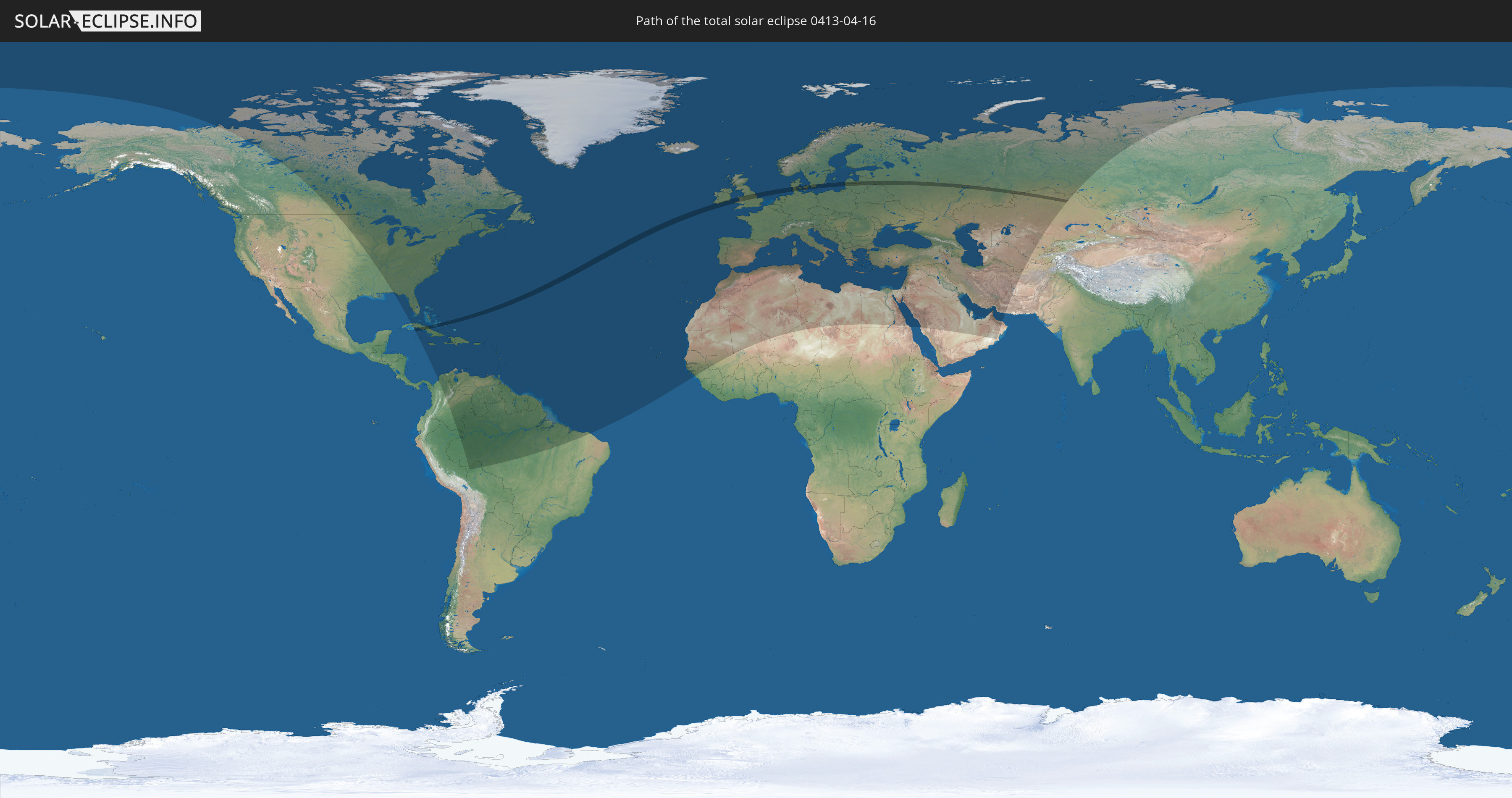
Die Sonnenfinsternis am 16.04.0413 kann man in 128 Ländern als partielle Sonnenfinsternis beobachten.
Der Finsternispfad verläuft durch 12 Länder. Nur in diesen Ländern ist sie als totale Sonnenfinsternis zu sehen.
In den folgenden Ländern ist die Sonnenfinsternis total zu sehen
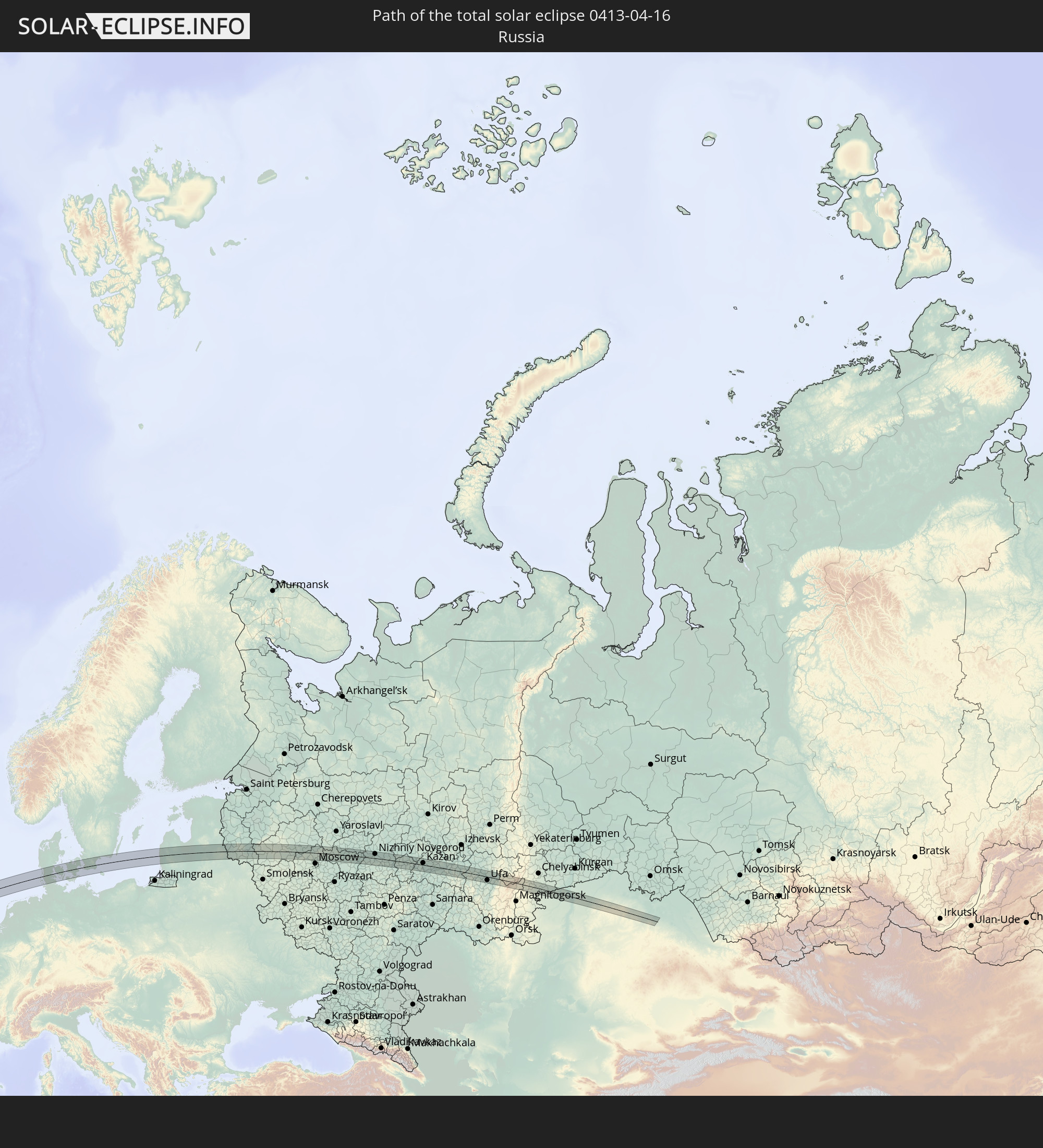 Russland
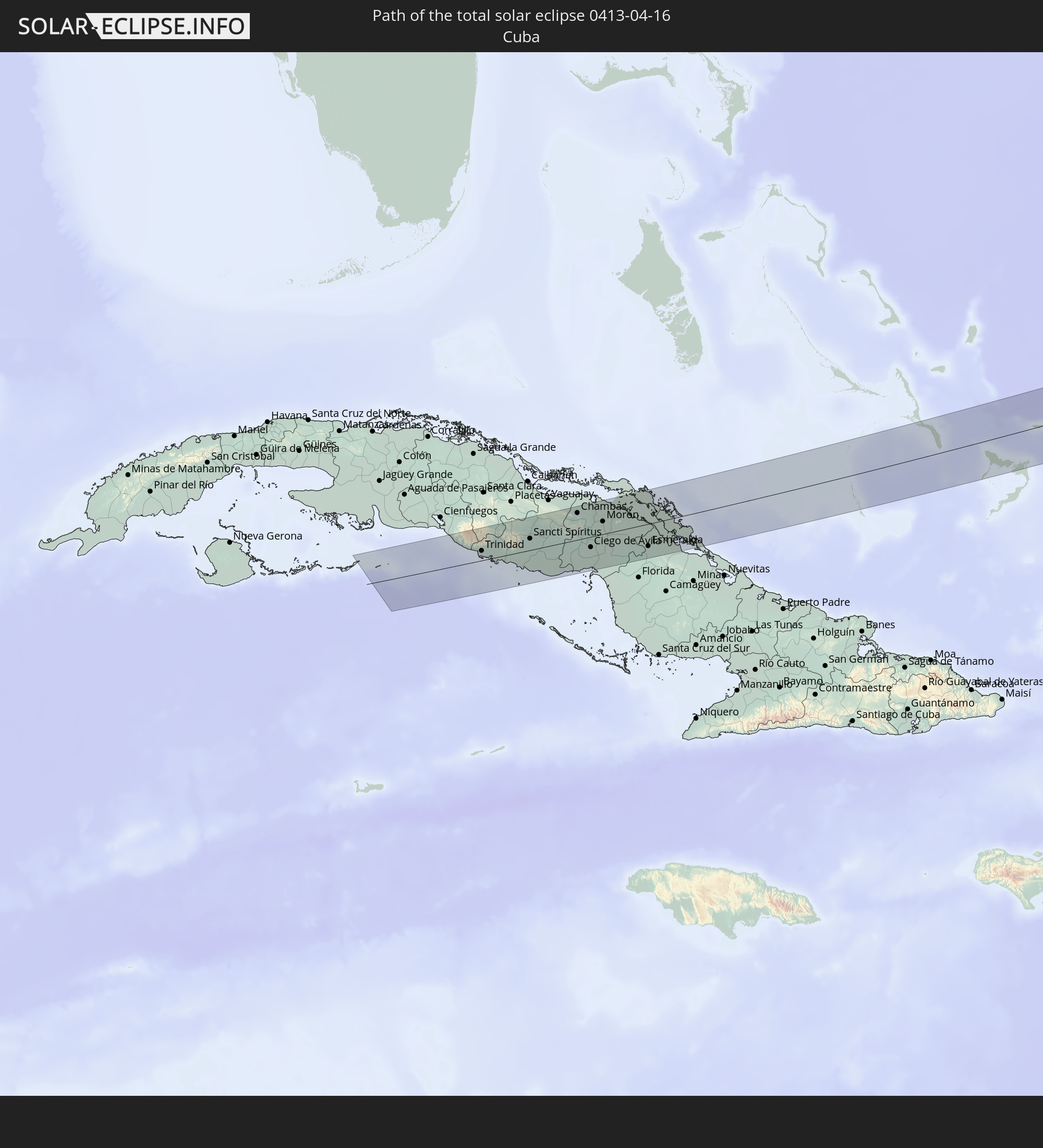 Kuba
Kuba
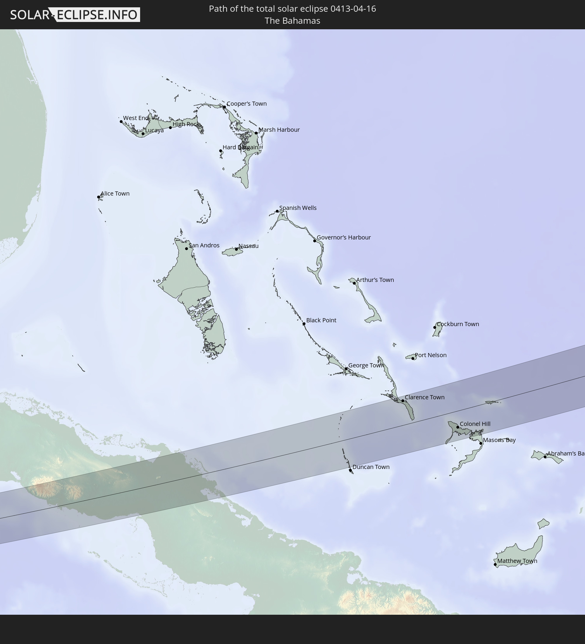 Bahamas
 Irland
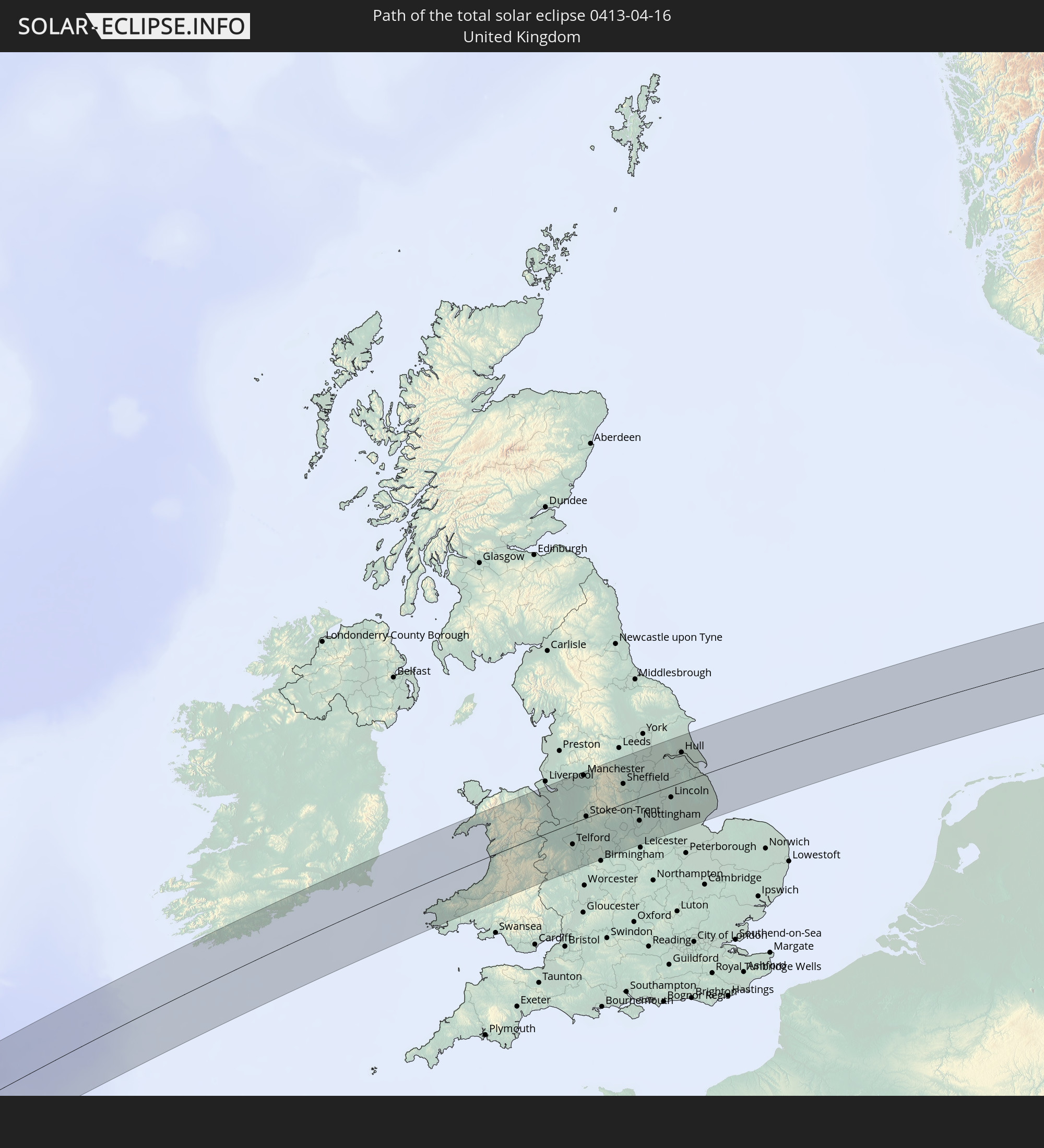 Vereinigtes Königreich
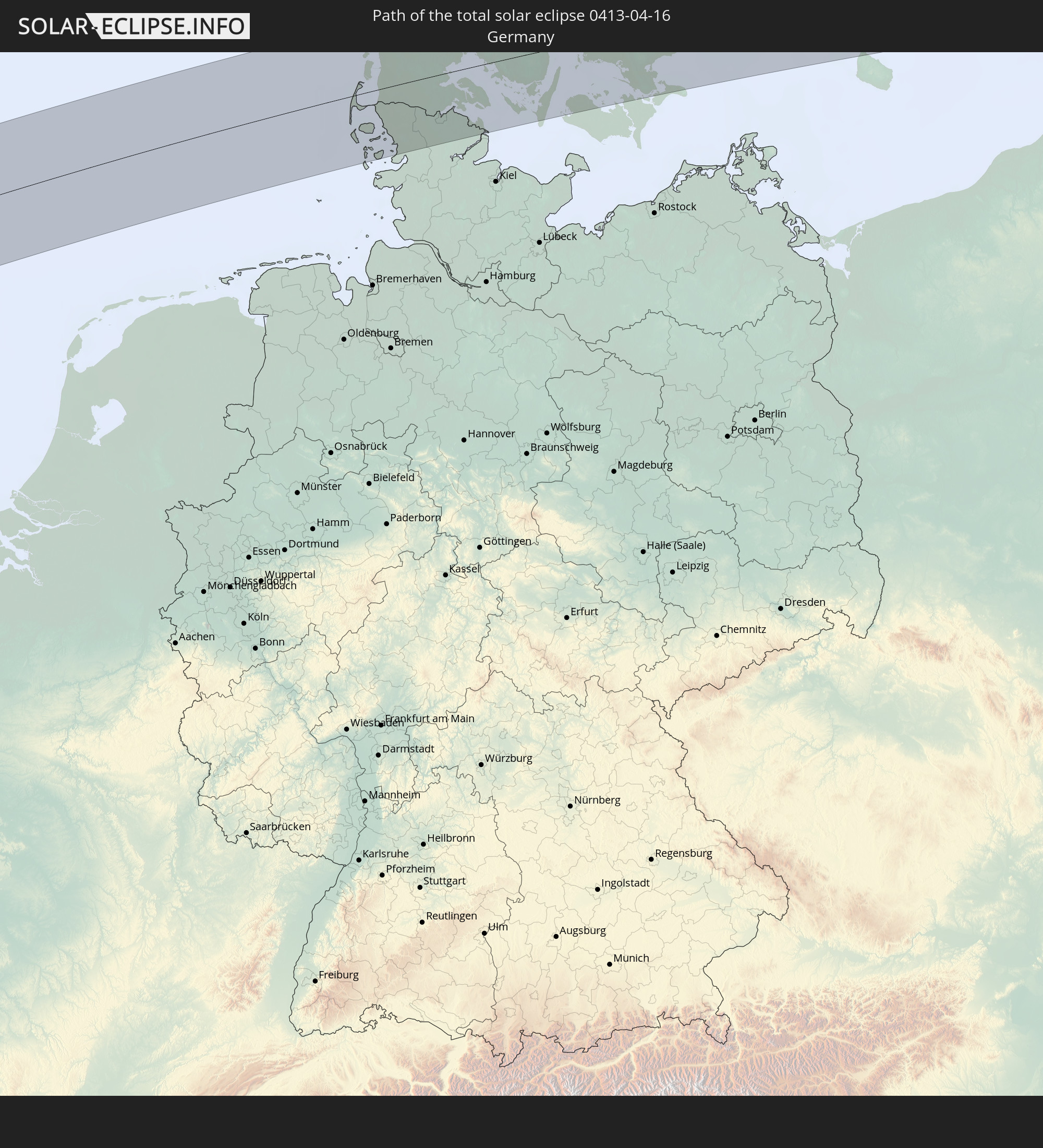 Deutschland
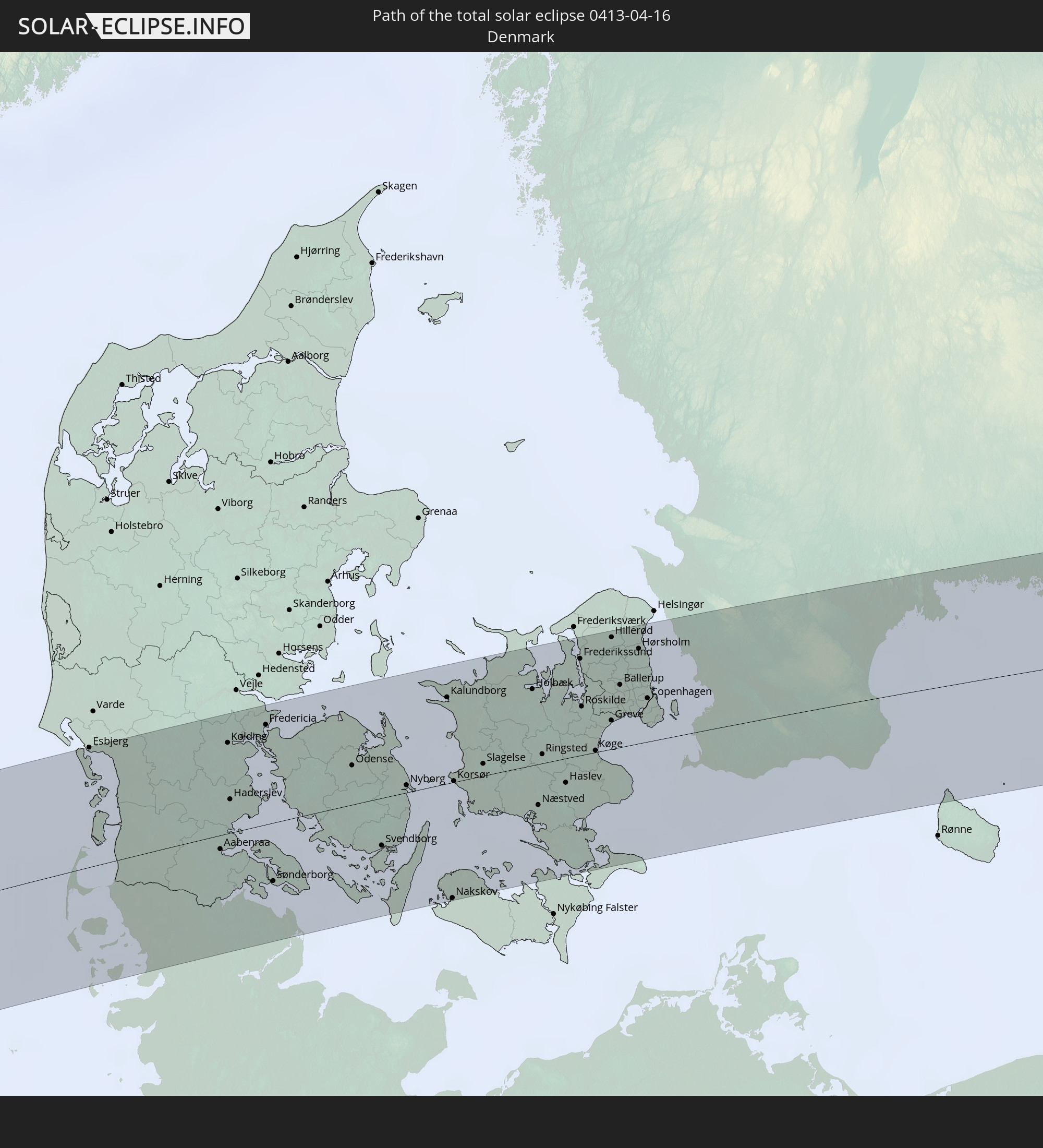 Dänemark
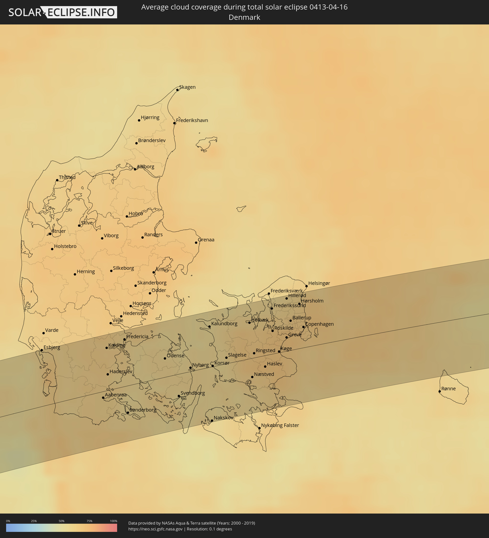
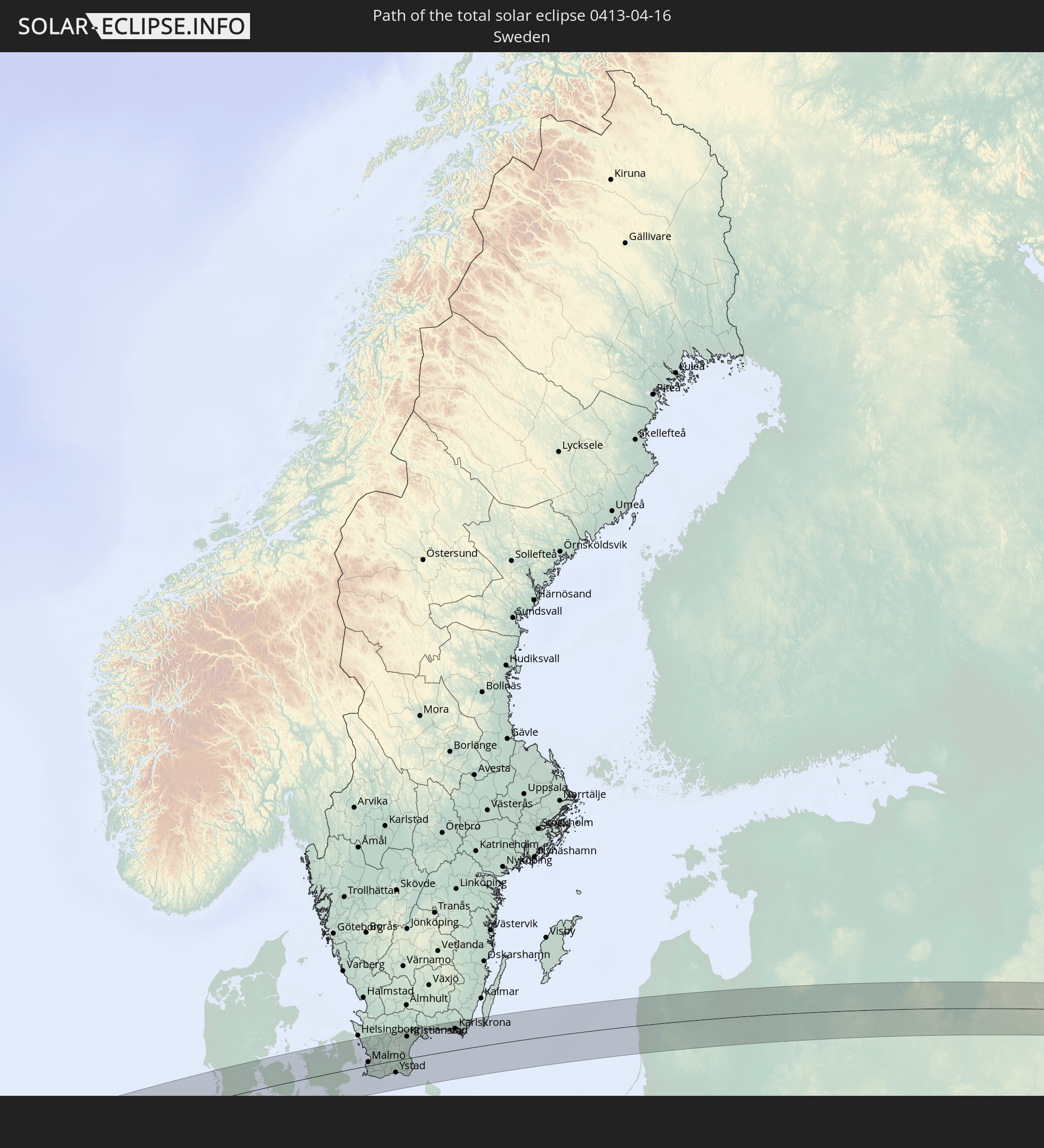 Schweden
 Litauen
 Lettland
 Weißrussland
 Kasachstan
In den folgenden Ländern ist die Sonnenfinsternis partiell zu sehen
 Russland
 Vereinigte Staaten
 United States Minor Outlying Islands
 Kanada
 Grönland
 Kuba
Kuba
 Kolumbien
 Kaimaninseln
 Peru
Peru
 Bahamas
 Jamaika
 Haiti
Haiti
 Brasilien
 Venezuela
 Turks- und Caicosinseln
 Dominikanische Republik
 Aruba
Aruba
 Bolivien
 Puerto Rico
 Amerikanische Jungferninseln
 Bermuda
 Britische Jungferninseln
 Anguilla
 Saint-Martin
 Saint-Barthélemy
 St. Kitts und Nevis
 Antigua und Barbuda
 Montserrat
 Trinidad und Tobago
 Guadeloupe
 Grenada
 Dominica
 St. Vincent und die Grenadinen
 Guyana
 Martinique
 St. Lucia
 Barbados
 Suriname
 Saint-Pierre und Miquelon
 Französisch-Guayana
 Portugal
 Kap Verde
 Island
 Spanien
 Senegal
 Mauretanien
 Gambia
 Guinea-Bissau
 Guinea
 Marokko
 Mali
Mali
 Irland
 Spitzbergen
 Algerien
 Vereinigtes Königreich
 Färöer
 Gibraltar
 Frankreich
 Isle of Man
 Guernsey
 Jersey
 Niger
Niger
 Andorra
 Belgien
 Niederlande
 Norwegen
 Luxemburg
 Deutschland
 Schweiz
 Italien
 Monaco
 Tunesien
 Dänemark
 Libyen
 Liechtenstein
 Österreich
 Schweden
 Tschechien
 San Marino
 Vatikanstadt
 Slowenien
 Tschad
 Kroatien
 Polen
Polen
 Malta
Malta
 Bosnien und Herzegowina
 Ungarn
 Slowakei
 Montenegro
 Serbien
 Albanien
 Åland Islands
 Griechenland
 Rumänien
 Mazedonien
 Finnland
 Litauen
 Lettland
 Estland
 Sudan
Sudan
 Ukraine
 Bulgarien
 Weißrussland
 Ägypten
 Türkei
 Moldawien
 Republik Zypern
 Staat Palästina
 Israel
 Saudi-Arabien
 Jordanien
 Libanon
 Syrien
 Irak
Irak
 Georgien
 Armenien
 Iran
Iran
 Aserbaidschan
 Kasachstan
 Kuwait
 Bahrain
 Katar
Katar
 Vereinigte Arabische Emirate
 Oman
Oman
 Turkmenistan
 Usbekistan
 Afghanistan
 Pakistan
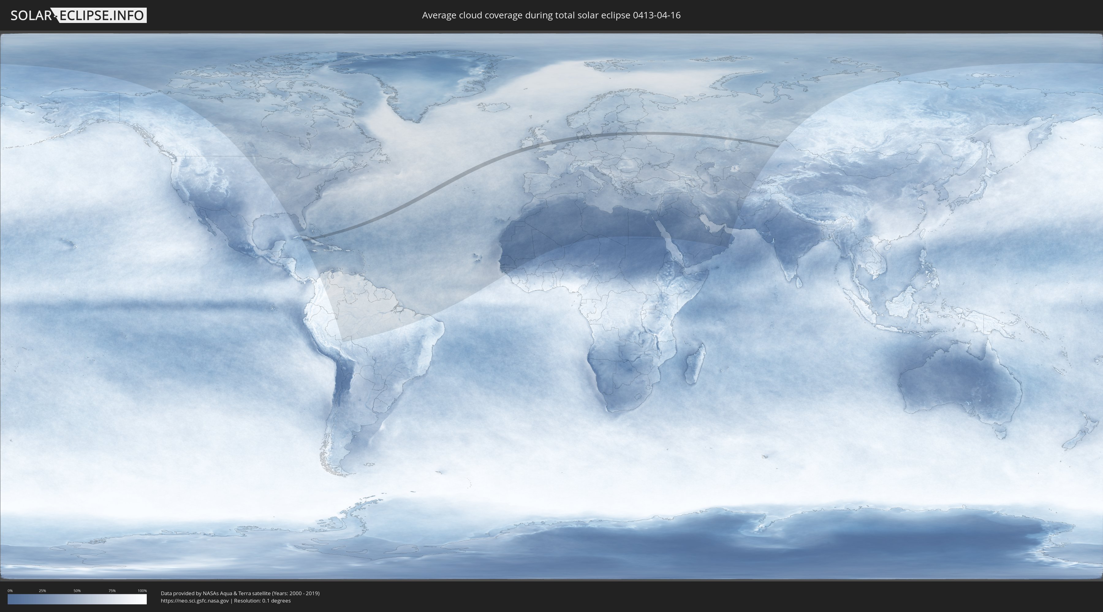
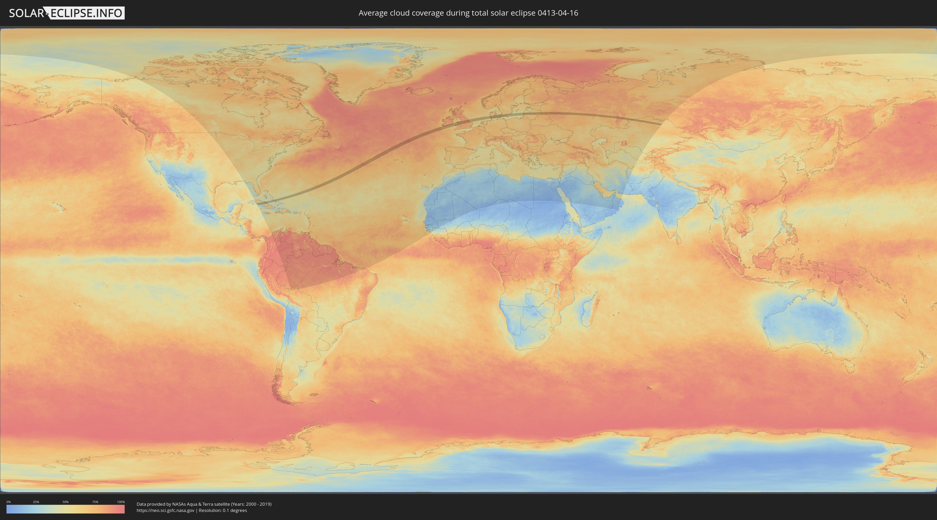
Wie wird das Wetter während der totalen Sonnenfinsternis am 16.04.0413?
Wo ist der beste Ort, um die totale Sonnenfinsternis vom 16.04.0413 zu beobachten?
Die folgenden Karten zeigen die durchschnittliche Bewölkung für den Tag, an dem die totale Sonnenfinsternis
stattfindet. Mit Hilfe der Karten lässt sich der Ort entlang des Finsternispfades eingrenzen,
der die besten Aussichen auf einen klaren wolkenfreien Himmel bietet.
Trotzdem muss man immer lokale Gegenenheiten beachten und sollte sich genau über das Wetter an seinem
gewählten Beobachtungsort informieren.
Die Daten stammen von den beiden NASA-Satelliten
AQUA und TERRA
und wurden über einen Zeitraum von 19 Jahren (2000 - 2019) gemittelt.
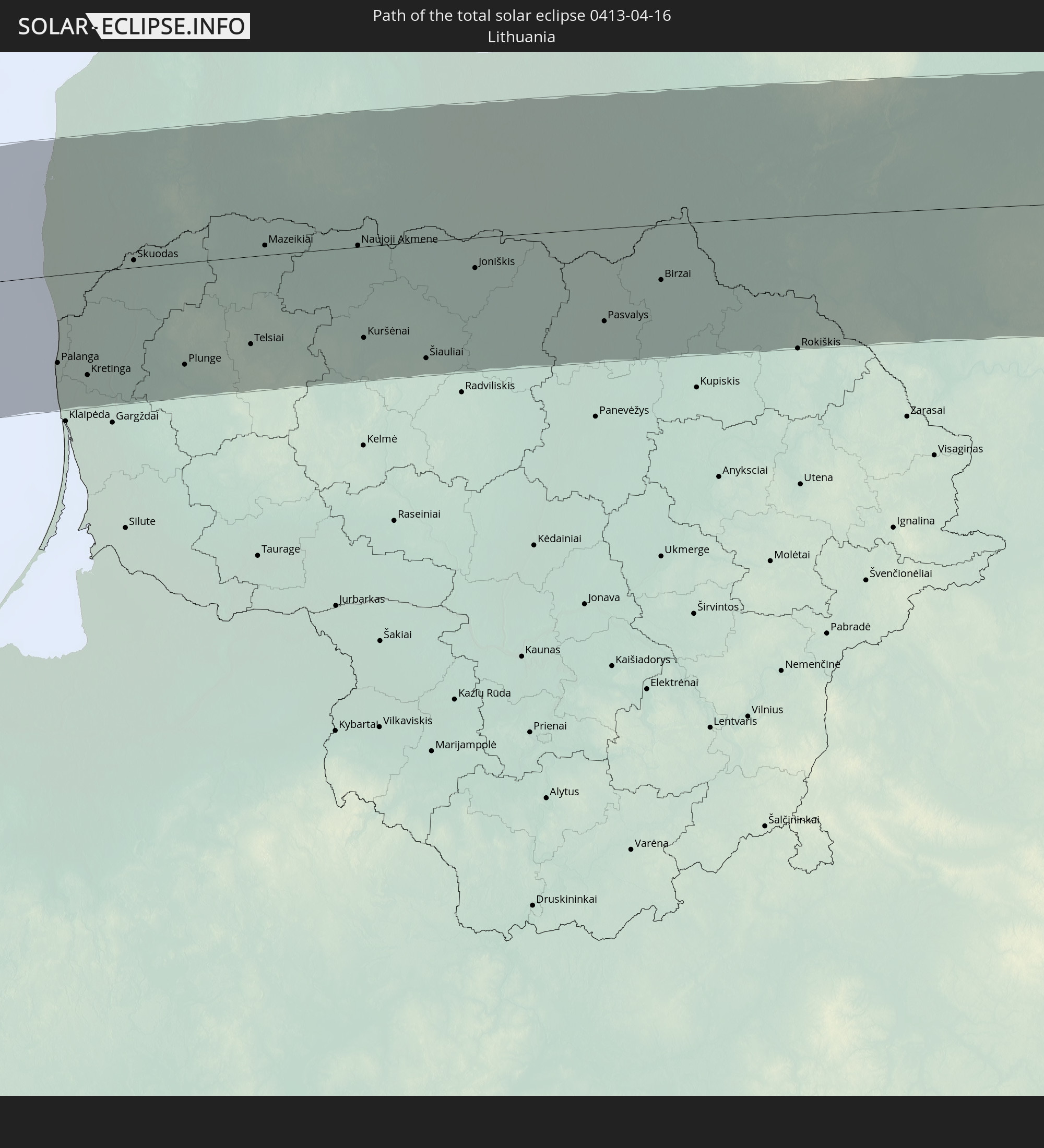
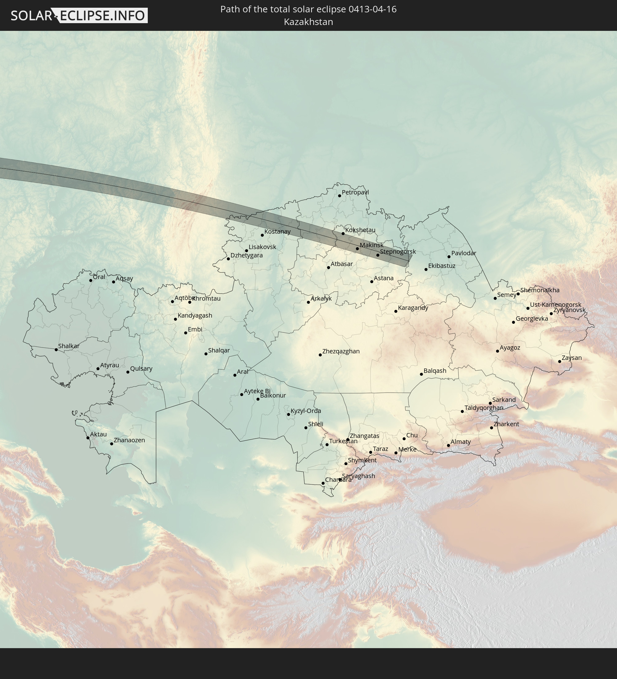
Detaillierte Länderkarten
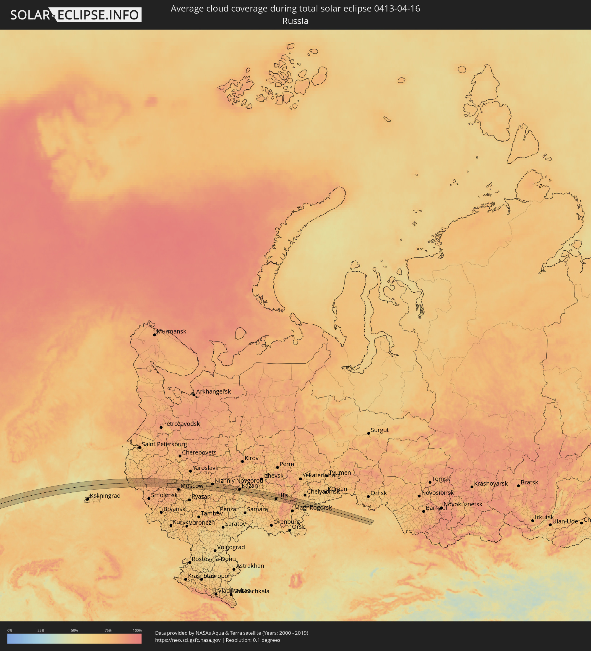 Russland
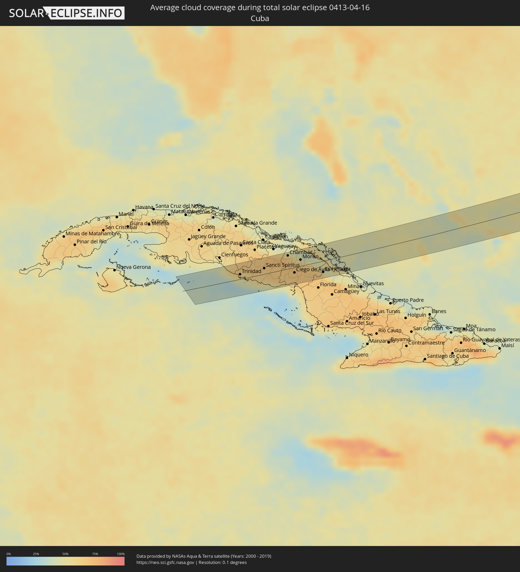 Kuba
Kuba
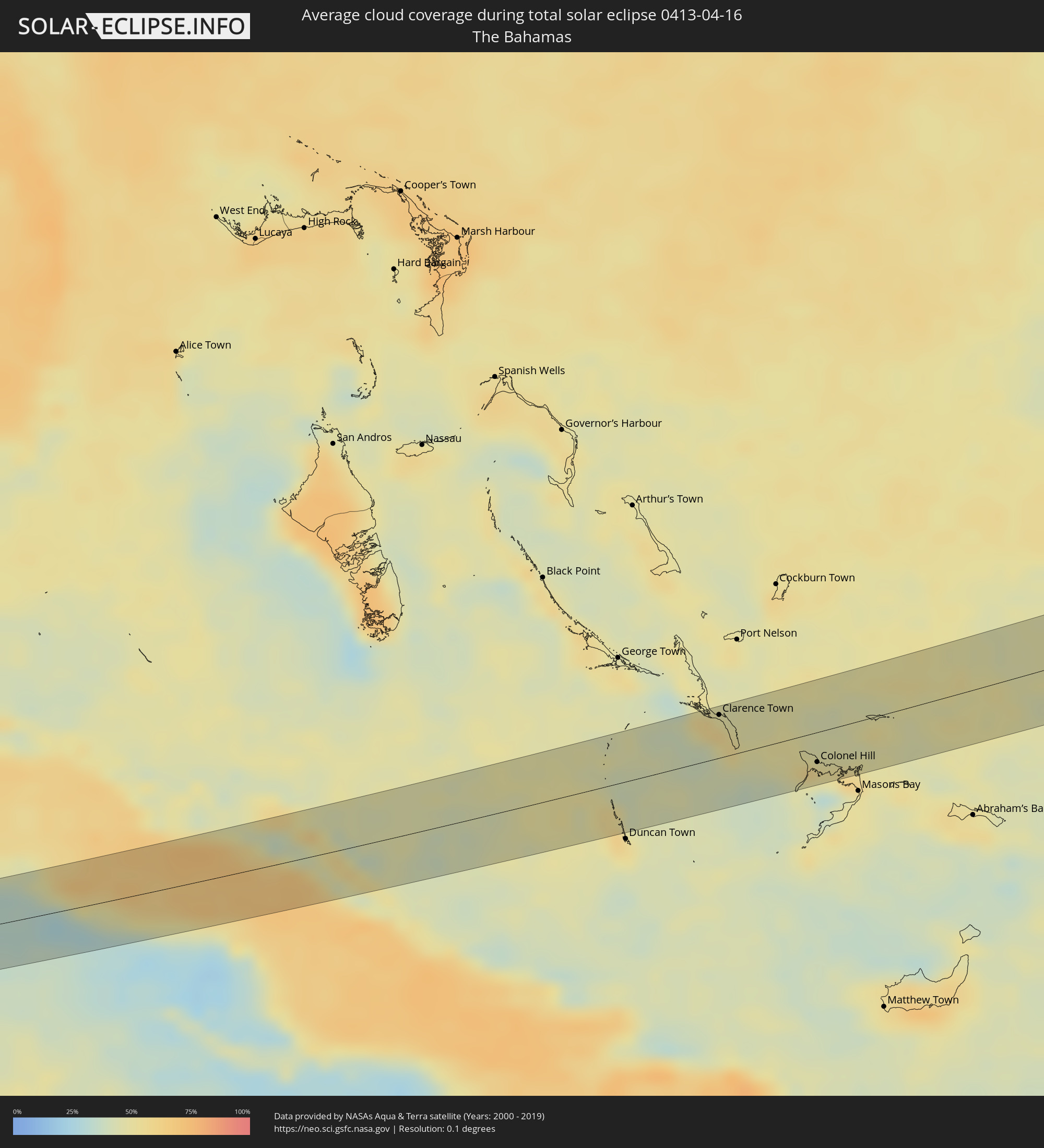 Bahamas
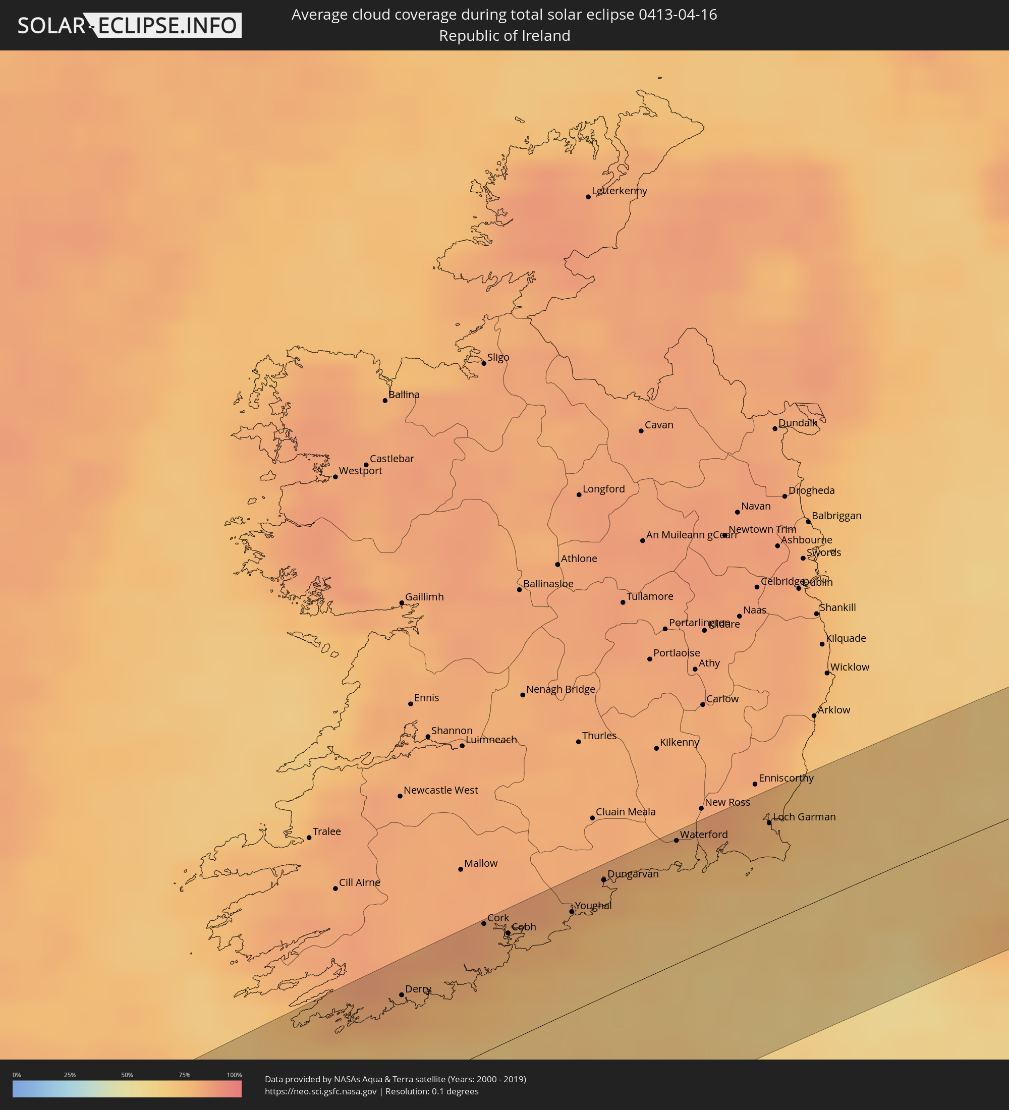 Irland
 Vereinigtes Königreich
 Deutschland
 Dänemark
 Schweden
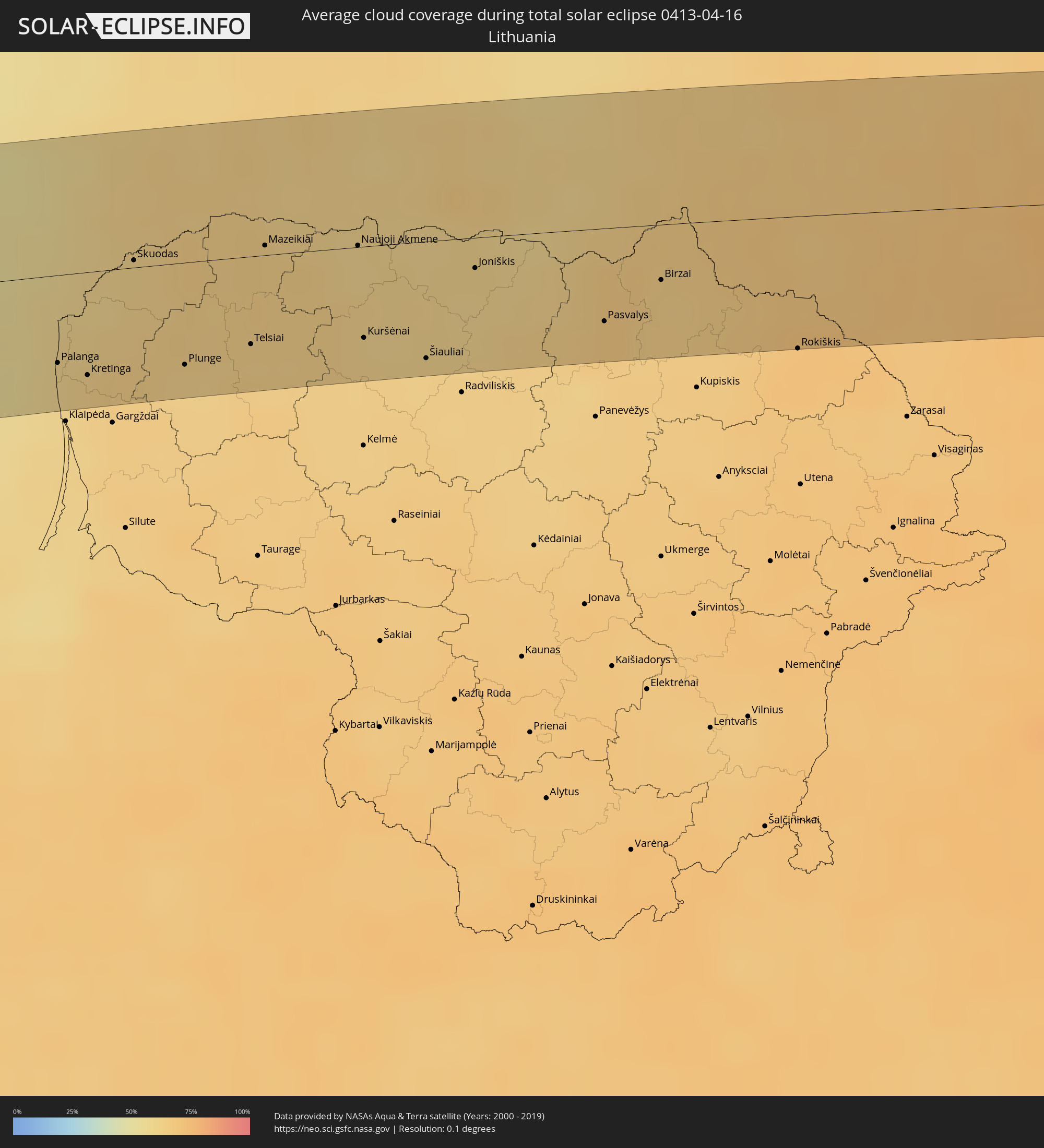 Litauen
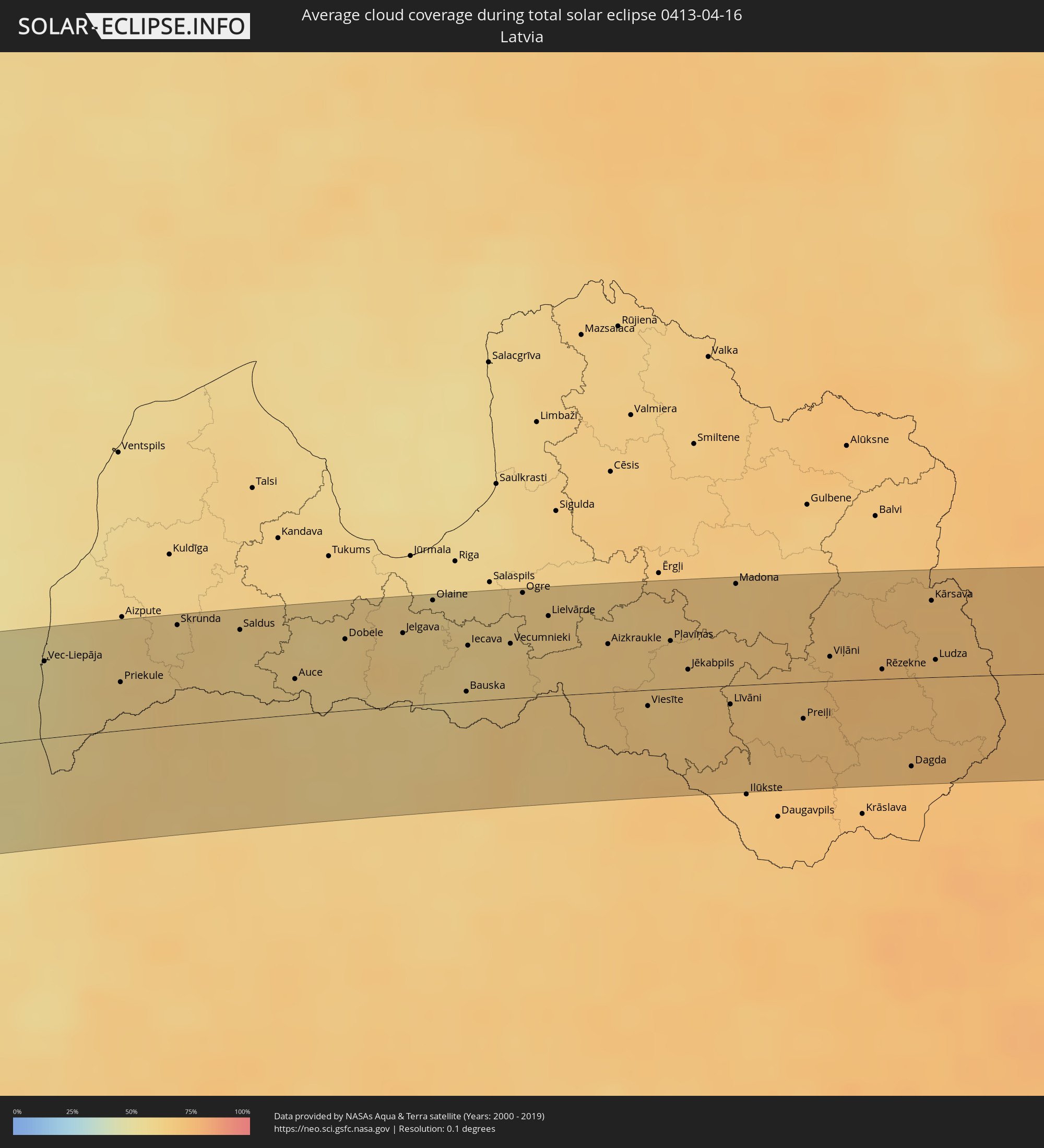 Lettland
 Weißrussland
 Kasachstan
Orte im Finsternispfad
Die nachfolgene Tabelle zeigt Städte und Orte mit mehr als 5.000 Einwohnern, die sich im Finsternispfad befinden. Städte mit mehr als 100.000 Einwohnern sind dick gekennzeichnet. Mit einem Klick auf den Ort öffnet sich eine Detailkarte die die Lage des jeweiligen Ortes zusammen mit dem Verlauf der zentralen Finsternis präsentiert.
| Ort | Typ | Dauer der Verfinsterung | Ortszeit bei maximaler Verfinsterung | Entfernung zur Zentrallinie | Ø Bewölkung |
|
Topes de Collantes, Sancti Spíritus
|
total | - | 05:37:30 UTC-05:29 | 24 km | 57% |
|
Trinidad, Sancti Spíritus
|
total | - | 05:37:22 UTC-05:29 | 11 km | 49% |
|
Condado, Sancti Spíritus
|
total | - | 05:37:26 UTC-05:29 | 16 km | 58% |
|
Cabaiguán, Sancti Spíritus
|
total | - | 05:37:37 UTC-05:29 | 30 km | 65% |
|
Guayos, Sancti Spíritus
|
total | - | 05:37:34 UTC-05:29 | 26 km | 64% |
|
Sancti Spíritus, Sancti Spíritus
|
total | - | 05:37:25 UTC-05:29 | 13 km | 62% |
|
Zaza del Medio, Sancti Spíritus
|
total | - | 05:37:29 UTC-05:29 | 19 km | 62% |
|
La Sierpe, Sancti Spíritus
|
total | - | 05:37:13 UTC-05:29 | 8 km | 61% |
|
Jatibonico, Sancti Spíritus
|
total | - | 05:37:24 UTC-05:29 | 9 km | 66% |
|
Florencia, Ciego de Ávila
|
total | - | 05:37:36 UTC-05:29 | 26 km | 67% |
|
Chambas, Ciego de Ávila
|
total | - | 05:37:39 UTC-05:29 | 30 km | 67% |
|
Venezuela, Ciego de Ávila
|
total | - | 05:37:06 UTC-05:29 | 22 km | 57% |
|
Ciego de Ávila, Ciego de Ávila
|
total | - | 05:37:13 UTC-05:29 | 12 km | 65% |
|
Ciro Redondo, Ciego de Ávila
|
total | - | 05:37:25 UTC-05:29 | 6 km | 66% |
|
Morón, Ciego de Ávila
|
total | - | 05:37:31 UTC-05:29 | 14 km | 64% |
|
Baraguá, Ciego de Ávila
|
total | - | 05:37:00 UTC-05:29 | 32 km | 66% |
|
Primero de Enero, Ciego de Ávila
|
total | - | 05:37:17 UTC-05:29 | 8 km | 68% |
|
Esmeralda, Camagüey
|
total | - | 05:37:08 UTC-05:29 | 25 km | 61% |
|
Clarence Town, Long Island
|
total | - | 05:58:30 UTC-05:09 | 34 km | 58% |
|
Colonel Hill, Crooked Island and Long Cay
|
total | - | 05:58:02 UTC-05:09 | 24 km | 53% |
|
Derry, Munster
|
total | - | 12:32:08 UTC-00:25 | 42 km | 80% |
|
Bandon, Munster
|
total | - | 12:32:41 UTC-00:25 | 49 km | 78% |
|
Cork, Munster
|
total | - | 12:33:10 UTC-00:25 | 57 km | 83% |
|
Carrigaline, Munster
|
total | - | 12:33:13 UTC-00:25 | 46 km | 79% |
|
Cobh, Munster
|
total | - | 12:33:24 UTC-00:25 | 47 km | 79% |
|
Midleton, Munster
|
total | - | 12:33:36 UTC-00:25 | 50 km | 77% |
|
Youghal, Munster
|
total | - | 12:34:06 UTC-00:25 | 44 km | 78% |
|
Dungarvan, Munster
|
total | - | 12:34:30 UTC-00:25 | 51 km | 77% |
|
Trá Mhór, Munster
|
total | - | 12:35:14 UTC-00:25 | 45 km | 76% |
|
Waterford, Munster
|
total | - | 12:35:20 UTC-00:25 | 54 km | 77% |
|
Loch Garman, Leinster
|
total | - | 12:36:19 UTC-00:25 | 43 km | 76% |
|
Chester, England
|
total | - | 13:07:02 UTC+00:00 | 38 km | 81% |
|
Shrewsbury, England
|
total | - | 13:07:08 UTC+00:00 | 15 km | 82% |
|
Warrington, England
|
total | - | 13:07:30 UTC+00:00 | 52 km | 81% |
|
Telford, England
|
total | - | 13:07:34 UTC+00:00 | 26 km | 82% |
|
Crewe, England
|
total | - | 13:07:39 UTC+00:00 | 18 km | 80% |
|
Manchester, England
|
total | - | 13:07:59 UTC+00:00 | 52 km | 80% |
|
Stoke-on-Trent, England
|
total | - | 13:07:59 UTC+00:00 | 2 km | 80% |
|
Wolverhampton, England
|
total | - | 13:08:01 UTC+00:00 | 43 km | 79% |
|
High Peak, England
|
total | - | 13:08:31 UTC+00:00 | 31 km | 82% |
|
Sutton Coldfield, England
|
total | - | 13:08:27 UTC+00:00 | 53 km | 81% |
|
Wakefield, England
|
total | - | 13:09:02 UTC+00:00 | 56 km | 83% |
|
Derby, England
|
total | - | 13:08:59 UTC+00:00 | 24 km | 81% |
|
Sheffield, England
|
total | - | 13:09:03 UTC+00:00 | 24 km | 82% |
|
Chesterfield, England
|
total | - | 13:09:06 UTC+00:00 | 9 km | 83% |
|
Mansfield, England
|
total | - | 13:09:23 UTC+00:00 | 8 km | 82% |
|
Nottingham, England
|
total | - | 13:09:27 UTC+00:00 | 28 km | 79% |
|
Scunthorpe, England
|
total | - | 13:10:11 UTC+00:00 | 26 km | 80% |
|
Lincoln, England
|
total | - | 13:10:19 UTC+00:00 | 14 km | 80% |
|
Hull, England
|
total | - | 13:10:38 UTC+00:00 | 36 km | 80% |
|
Westerland, Schleswig-Holstein
|
total | - | 14:21:33 UTC+01:00 | 4 km | 61% |
|
Sylt-Ost, Schleswig-Holstein
|
total | - | 14:21:42 UTC+01:00 | 11 km | 59% |
|
Esbjerg, South Denmark
|
total | - | 14:21:30 UTC+01:00 | 54 km | 61% |
|
Niebüll, Schleswig-Holstein
|
total | - | 14:22:13 UTC+01:00 | 25 km | 62% |
|
Bredstedt, Schleswig-Holstein
|
total | - | 14:22:27 UTC+01:00 | 46 km | 60% |
|
Leck, Schleswig-Holstein
|
total | - | 14:22:25 UTC+01:00 | 30 km | 63% |
|
Handewitt, Schleswig-Holstein
|
total | - | 14:22:50 UTC+01:00 | 35 km | 64% |
|
Harrislee, Schleswig-Holstein
|
total | - | 14:22:53 UTC+01:00 | 32 km | 64% |
|
Tarp, Schleswig-Holstein
|
total | - | 14:22:57 UTC+01:00 | 47 km | 64% |
|
Aabenraa, South Denmark
|
total | - | 14:22:49 UTC+01:00 | 6 km | 60% |
|
Flensburg, Schleswig-Holstein
|
total | - | 14:22:57 UTC+01:00 | 35 km | 64% |
|
Kolding, South Denmark
|
total | - | 14:22:41 UTC+01:00 | 41 km | 62% |
|
Haderslev, South Denmark
|
total | - | 14:22:49 UTC+01:00 | 15 km | 61% |
|
Glücksburg, Schleswig-Holstein
|
total | - | 14:23:04 UTC+01:00 | 31 km | 64% |
|
Fredericia, South Denmark
|
total | - | 14:22:59 UTC+01:00 | 45 km | 59% |
|
Sønderborg, South Denmark
|
total | - | 14:23:20 UTC+01:00 | 27 km | 59% |
|
Odense, South Denmark
|
total | - | 14:23:47 UTC+01:00 | 18 km | 59% |
|
Svendborg, South Denmark
|
total | - | 14:24:12 UTC+01:00 | 22 km | 55% |
|
Kalundborg, Zealand
|
total | - | 14:24:27 UTC+01:00 | 39 km | 56% |
|
Slagelse, Zealand
|
total | - | 14:24:53 UTC+01:00 | 5 km | 59% |
|
Holbæk, Zealand
|
total | - | 14:25:08 UTC+01:00 | 35 km | 64% |
|
Næstved, Zealand
|
total | - | 14:25:26 UTC+01:00 | 19 km | 60% |
|
Ringsted, Zealand
|
total | - | 14:25:22 UTC+01:00 | 4 km | 68% |
|
Roskilde, Zealand
|
total | - | 14:25:35 UTC+01:00 | 22 km | 68% |
|
Køge, Zealand
|
total | - | 14:25:47 UTC+01:00 | 1 km | 67% |
|
Stenløse, Capital Region
|
total | - | 14:25:38 UTC+01:00 | 34 km | 62% |
|
Greve, Zealand
|
total | - | 14:25:51 UTC+01:00 | 13 km | 69% |
|
Hørsholm, Capital Region
|
total | - | 14:25:55 UTC+01:00 | 43 km | 63% |
|
Copenhagen, Capital Region
|
total | - | 14:26:06 UTC+01:00 | 20 km | 64% |
|
Landskrona, Skåne
|
total | - | 14:26:17 UTC+01:00 | 38 km | 66% |
|
Malmö, Skåne
|
total | - | 14:26:37 UTC+01:00 | 7 km | 63% |
|
Bjärred, Skåne
|
total | - | 14:26:34 UTC+01:00 | 19 km | 64% |
|
Lomma, Skåne
|
total | - | 14:26:39 UTC+01:00 | 13 km | 63% |
|
Arlöv, Skåne
|
total | - | 14:26:41 UTC+01:00 | 9 km | 63% |
|
Oxie, Skåne
|
total | - | 14:26:45 UTC+01:00 | 1 km | 63% |
|
Trelleborg, Skåne
|
total | - | 14:26:55 UTC+01:00 | 20 km | 62% |
|
Lund, Skåne
|
total | - | 14:26:46 UTC+01:00 | 15 km | 64% |
|
Svedala, Skåne
|
total | - | 14:26:56 UTC+01:00 | 7 km | 66% |
|
Eslöv, Skåne
|
total | - | 14:26:48 UTC+01:00 | 29 km | 63% |
|
Höör, Skåne
|
total | - | 14:27:00 UTC+01:00 | 36 km | 64% |
|
Ystad, Skåne
|
total | - | 14:27:37 UTC+01:00 | 22 km | 61% |
|
Kristianstad, Skåne
|
total | - | 14:27:36 UTC+01:00 | 40 km | 62% |
|
Åhus, Skåne
|
total | - | 14:27:49 UTC+01:00 | 26 km | 65% |
|
Bromölla, Skåne
|
total | - | 14:27:54 UTC+01:00 | 41 km | 63% |
|
Sölvesborg, Blekinge
|
total | - | 14:28:02 UTC+01:00 | 38 km | 61% |
|
Karlshamn, Blekinge
|
total | - | 14:28:15 UTC+01:00 | 48 km | 66% |
|
Ronneby, Blekinge
|
total | - | 14:28:39 UTC+01:00 | 48 km | 58% |
|
Karlskrona, Blekinge
|
total | - | 14:29:01 UTC+01:00 | 39 km | 57% |
|
Vec-Liepāja, Liepāja
|
total | - | 15:10:33 UTC+01:36 | 35 km | 54% |
|
Palanga, Klaipėda County
|
total | - | 14:58:33 UTC+01:24 | 33 km | 59% |
|
Kretinga, Klaipėda County
|
total | - | 14:58:45 UTC+01:24 | 39 km | 63% |
|
Skuodas, Klaipėda County
|
total | - | 14:58:40 UTC+01:24 | 3 km | 61% |
|
Plunge, Telšiai County
|
total | - | 14:59:16 UTC+01:24 | 38 km | 62% |
|
Telsiai, Telšiai County
|
total | - | 14:59:34 UTC+01:24 | 33 km | 63% |
|
Mazeikiai, Telšiai County
|
total | - | 14:59:21 UTC+01:24 | 4 km | 64% |
|
Saldus, Saldus Rajons
|
total | - | 15:11:44 UTC+01:36 | 41 km | 61% |
|
Naujoji Akmene
|
total | - | 14:59:51 UTC+01:24 | 1 km | 60% |
|
Auce, Auces Novads
|
total | - | 15:12:17 UTC+01:36 | 16 km | 61% |
|
Kuršėnai, Šiauliai County
|
total | - | 15:00:10 UTC+01:24 | 34 km | 62% |
|
Dobele, Dobeles Rajons
|
total | - | 15:12:27 UTC+01:36 | 33 km | 62% |
|
Šiauliai, Šiauliai County
|
total | - | 15:00:33 UTC+01:24 | 44 km | 62% |
|
Joniškis, Šiauliai County
|
total | - | 15:00:32 UTC+01:24 | 11 km | 60% |
|
Jelgava, Jelgava
|
total | - | 15:12:48 UTC+01:36 | 34 km | 61% |
|
Pakruojis, Šiauliai County
|
total | - | 15:01:00 UTC+01:24 | 43 km | 64% |
|
Olaine, Olaine
|
total | - | 15:12:52 UTC+01:36 | 48 km | 60% |
|
Bauska, Bauskas Rajons
|
total | - | 15:13:26 UTC+01:36 | 5 km | 61% |
|
Iecava, Lecava
|
total | - | 15:13:16 UTC+01:36 | 26 km | 59% |
|
Pasvalys, Panevėžys
|
total | - | 15:01:23 UTC+01:24 | 35 km | 66% |
|
Ogre, Ogre
|
total | - | 15:13:24 UTC+01:36 | 48 km | 62% |
|
Birzai, Panevėžys
|
total | - | 15:01:32 UTC+01:24 | 21 km | 63% |
|
Lielvārde, Lielvārde
|
total | - | 15:13:39 UTC+01:36 | 37 km | 63% |
|
Aizkraukle, Aizkraukles Rajons
|
total | - | 15:14:07 UTC+01:36 | 22 km | 65% |
|
Rokiškis, Panevėžys
|
total | - | 15:02:27 UTC+01:24 | 50 km | 70% |
|
Pļaviņas, Pļaviņu
|
total | - | 15:14:29 UTC+01:36 | 22 km | 66% |
|
Jēkabpils, Jēkabpils Municipality
|
total | - | 15:14:43 UTC+01:36 | 8 km | 68% |
|
Līvāni, Līvāni
|
total | - | 15:15:07 UTC+01:36 | 9 km | 68% |
|
Madona, Madonas Rajons
|
total | - | 15:14:39 UTC+01:36 | 47 km | 66% |
|
Preiļi, Preiļu Rajons
|
total | - | 15:15:37 UTC+01:36 | 17 km | 70% |
|
Viļāni, Vilanu
|
total | - | 15:15:30 UTC+01:36 | 11 km | 71% |
|
Rēzekne, Rēzekne
|
total | - | 15:15:52 UTC+01:36 | 4 km | 73% |
|
Ludza, Ludzas Rajons
|
total | - | 15:16:08 UTC+01:36 | 8 km | 71% |
|
Velikiye Luki, Pskov
|
total | - | 16:12:08 UTC+02:30 | 18 km | 76% |
|
Tver, Tverskaya
|
total | - | 16:14:56 UTC+02:30 | 47 km | 79% |
|
Klin, Moscow Oblast
|
total | - | 16:16:02 UTC+02:30 | 9 km | 80% |
|
Pushkino, Moscow Oblast
|
total | - | 16:17:02 UTC+02:30 | 40 km | 77% |
|
Sergiyev Posad, Moscow Oblast
|
total | - | 16:16:50 UTC+02:30 | 8 km | 78% |
|
Aleksandrov, Vladimir
|
total | - | 16:17:02 UTC+02:30 | 5 km | 74% |
|
Vladimir, Vladimir
|
total | - | 16:18:11 UTC+02:30 | 15 km | 72% |
|
Kovrov, Vladimir
|
total | - | 16:18:20 UTC+02:30 | 14 km | 74% |
|
Dzerzhinsk, Nizjnij Novgorod
|
total | - | 16:19:24 UTC+02:30 | 15 km | 74% |
|
Nizhniy Novgorod, Nizjnij Novgorod
|
total | - | 16:19:31 UTC+02:30 | 29 km | 76% |
|
Kstovo, Nizjnij Novgorod
|
total | - | 16:19:49 UTC+02:30 | 10 km | 74% |
|
Cheboksary, Chuvashia
|
total | - | 16:20:56 UTC+02:30 | 33 km | 79% |
|
Zelenodolsk, Tatarstan
|
total | - | 16:21:42 UTC+02:30 | 13 km | 74% |
|
Kazan, Tatarstan
|
total | - | 16:21:57 UTC+02:30 | 13 km | 72% |
|
Nizhnekamsk, Tatarstan
|
total | - | 16:22:51 UTC+02:30 | 24 km | 67% |
|
Yelabuga, Tatarstan
|
total | - | 16:22:44 UTC+02:30 | 41 km | 70% |
|
Naberezhnyye Chelny, Tatarstan
|
total | - | 16:22:52 UTC+02:30 | 41 km | 73% |
|
Ufa, Bashkortostan
|
total | - | 17:57:02 UTC+04:02 | 23 km | 67% |
|
Troitsk, Chelyabinsk
|
total | - | 17:58:19 UTC+04:02 | 13 km | 64% |
|
Borovskoy, Qostanay
|
total | - | 18:18:01 UTC+04:21 | 3 km | 66% |
|
Novoishimskiy, Soltüstik Qazaqstan
|
total | - | 18:18:37 UTC+04:21 | 23 km | 71% |
|
Kokshetau, Aqmola
|
total | - | 18:18:15 UTC+04:21 | 34 km | 67% |
|
Shchuchinsk, Aqmola
|
total | - | 18:18:33 UTC+04:21 | 11 km | 73% |
|
Būrabay, Soltüstik Qazaqstan
|
total | - | 18:18:22 UTC+04:21 | 30 km | 73% |
|
Makinsk, Aqmola
|
total | - | 18:18:53 UTC+04:21 | 17 km | 76% |
|
Stepnogorsk, Aqmola
|
total | - | 18:18:58 UTC+04:21 | 18 km | 68% |
|
Aksu, Aqmola
|
total | - | 18:18:51 UTC+04:21 | 7 km | 68% |
|
Zavodskoy, Aqmola
|
total | - | 18:18:48 UTC+04:21 | 3 km | 69% |
|
Bestobe, Aqmola
|
total | - | 18:18:35 UTC+04:21 | 21 km | 66% |