Totale Sonnenfinsternis vom 29.05.0485
| Wochentag: | Dienstag |
| Maximale Dauer der Verfinsterung: | 02m26s |
| Maximale Breite des Finsternispfades: | 301 km |
| Saroszyklus: | 74 |
| Bedeckungsgrad: | 100% |
| Magnitude: | 1.042 |
| Gamma: | 0.8814 |
Wo kann man die Sonnenfinsternis vom 29.05.0485 sehen?
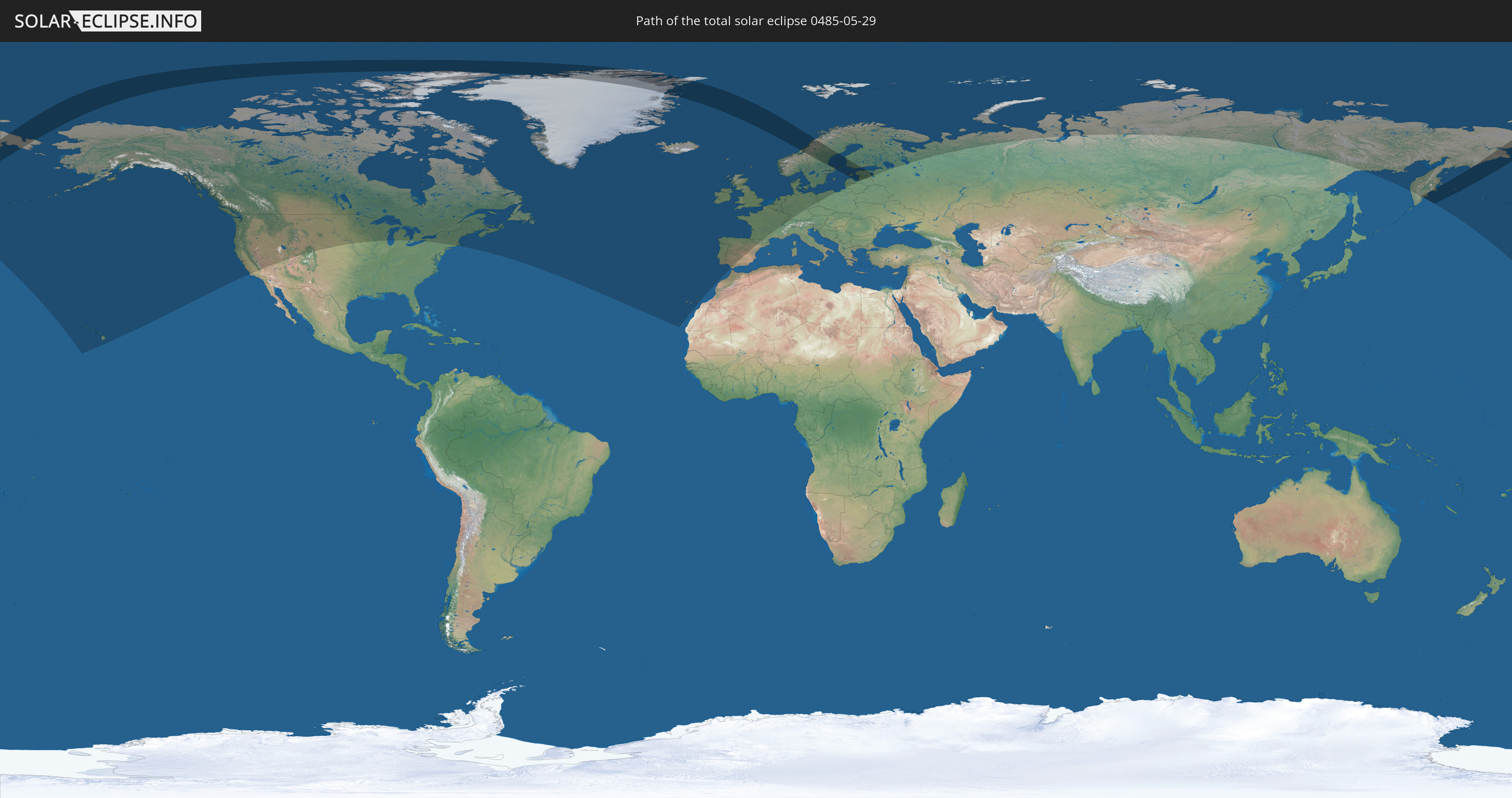
Die Sonnenfinsternis am 29.05.0485 kann man in 31 Ländern als partielle Sonnenfinsternis beobachten.
Der Finsternispfad verläuft durch 9 Länder. Nur in diesen Ländern ist sie als totale Sonnenfinsternis zu sehen.
In den folgenden Ländern ist die Sonnenfinsternis total zu sehen
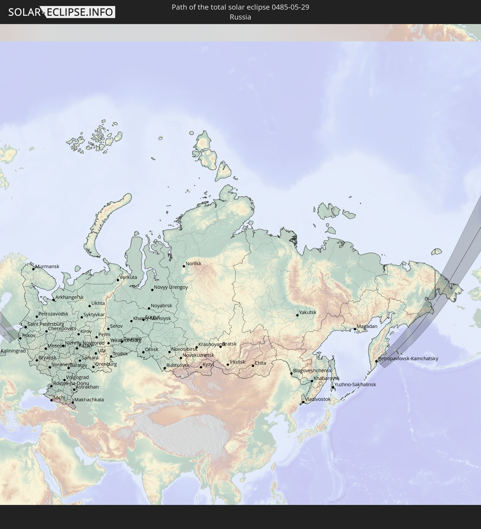 Russland
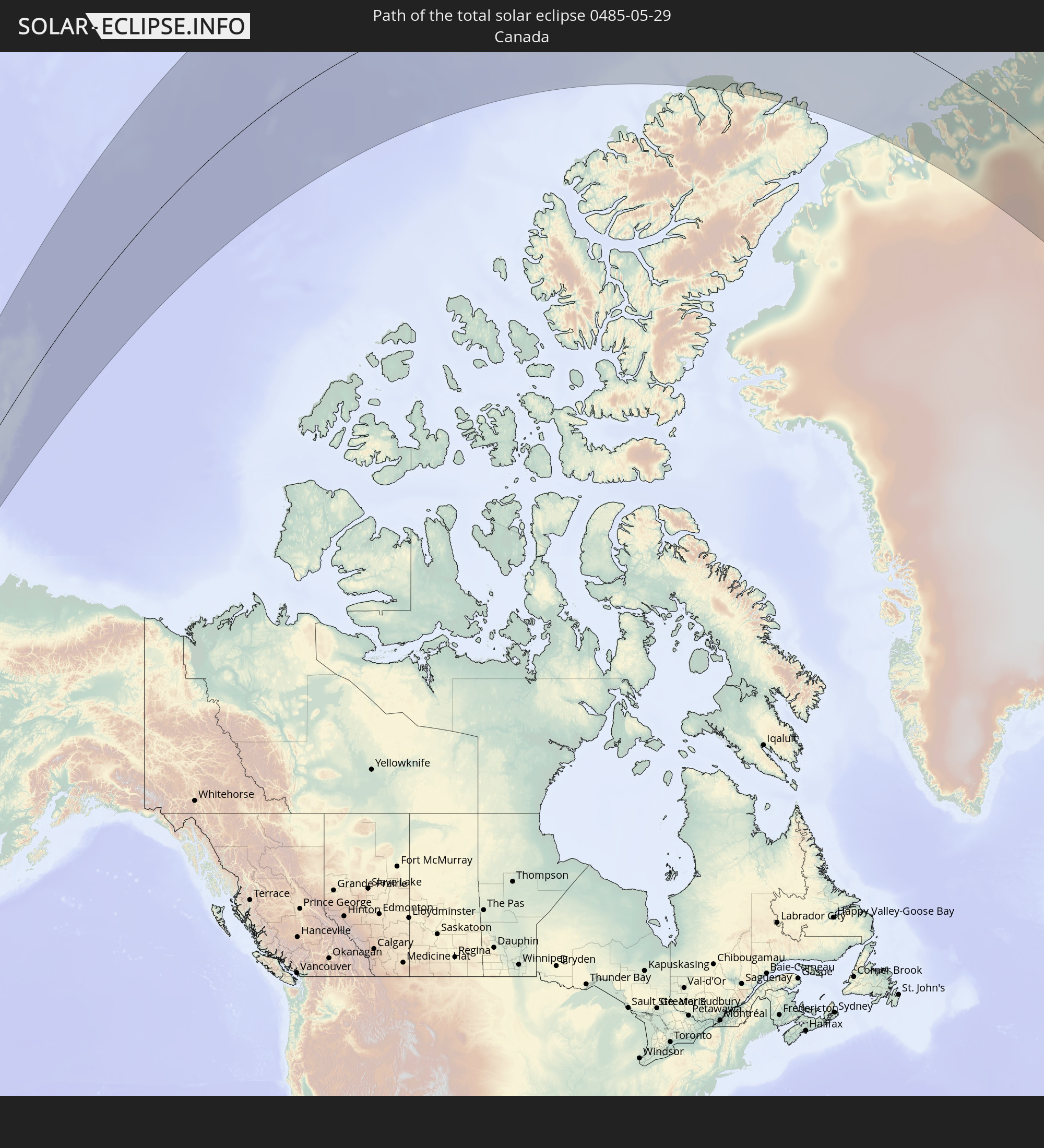 Kanada
 Grönland
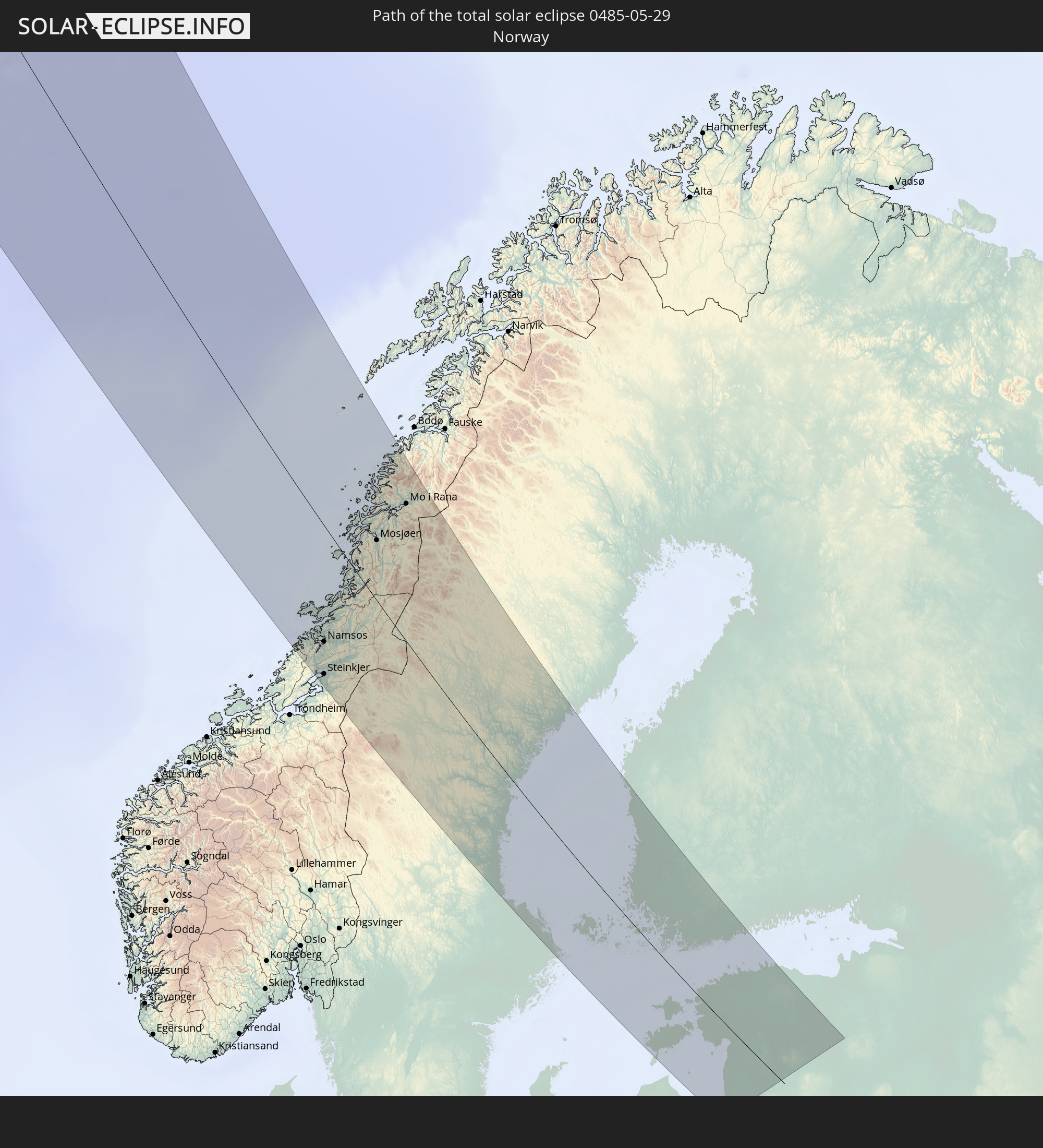 Norwegen
 Schweden
 Åland Islands
 Finnland
 Lettland
 Estland
In den folgenden Ländern ist die Sonnenfinsternis partiell zu sehen
 Russland
 Vereinigte Staaten
 United States Minor Outlying Islands
 Kanada
 Grönland
 Saint-Pierre und Miquelon
 Portugal
 Island
 Spanien
 Irland
 Spitzbergen
 Vereinigtes Königreich
 Färöer
 Frankreich
 Isle of Man
 Guernsey
 Jersey
 Belgien
 Niederlande
 Norwegen
 Luxemburg
 Deutschland
 Schweiz
 Dänemark
 Schweden
 Polen
Polen
 Åland Islands
 Finnland
 Litauen
 Lettland
 Estland
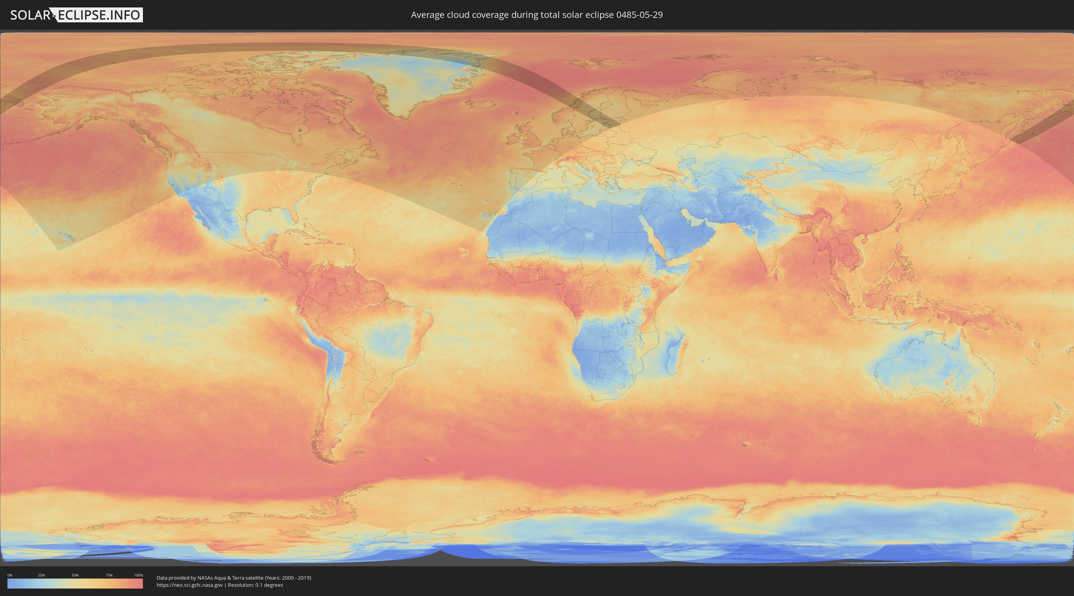
Wie wird das Wetter während der totalen Sonnenfinsternis am 29.05.0485?
Wo ist der beste Ort, um die totale Sonnenfinsternis vom 29.05.0485 zu beobachten?
Die folgenden Karten zeigen die durchschnittliche Bewölkung für den Tag, an dem die totale Sonnenfinsternis
stattfindet. Mit Hilfe der Karten lässt sich der Ort entlang des Finsternispfades eingrenzen,
der die besten Aussichen auf einen klaren wolkenfreien Himmel bietet.
Trotzdem muss man immer lokale Gegenenheiten beachten und sollte sich genau über das Wetter an seinem
gewählten Beobachtungsort informieren.
Die Daten stammen von den beiden NASA-Satelliten
AQUA und TERRA
und wurden über einen Zeitraum von 19 Jahren (2000 - 2019) gemittelt.

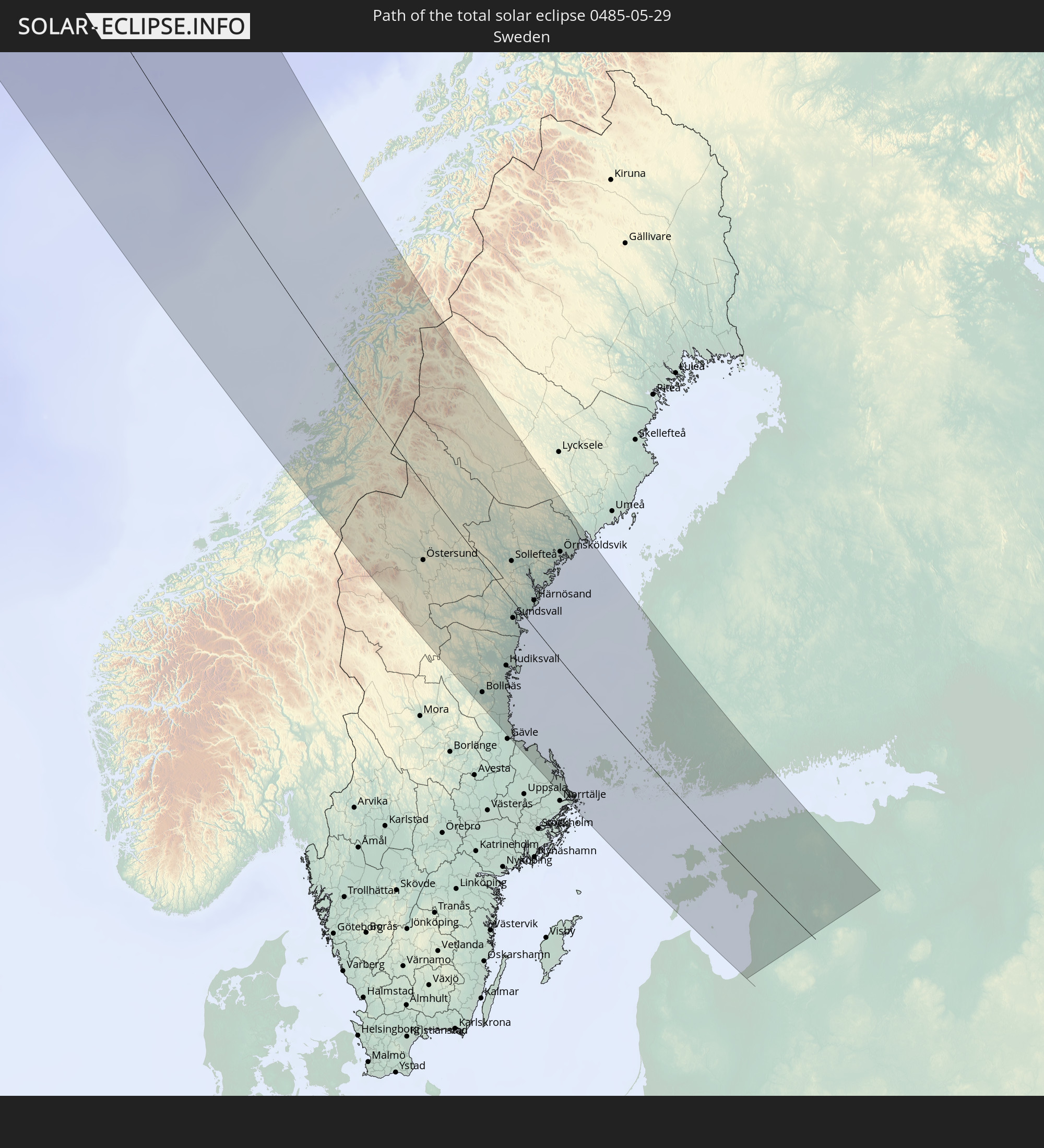
Detaillierte Länderkarten
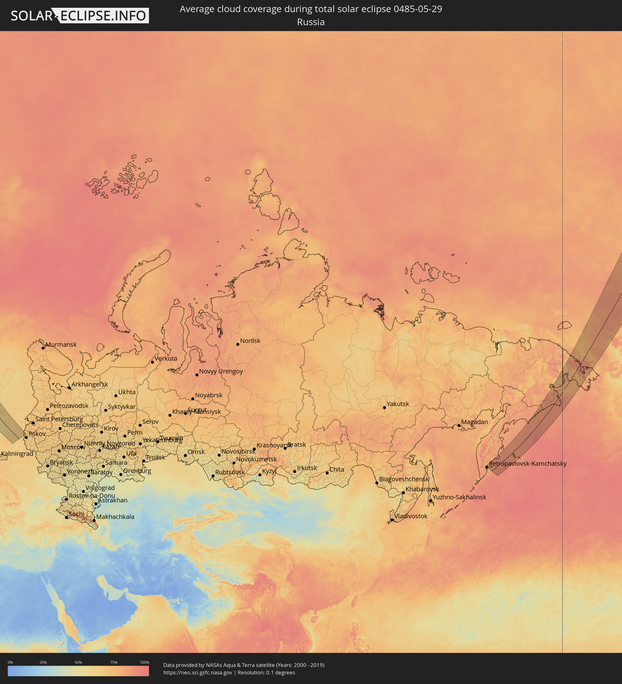 Russland
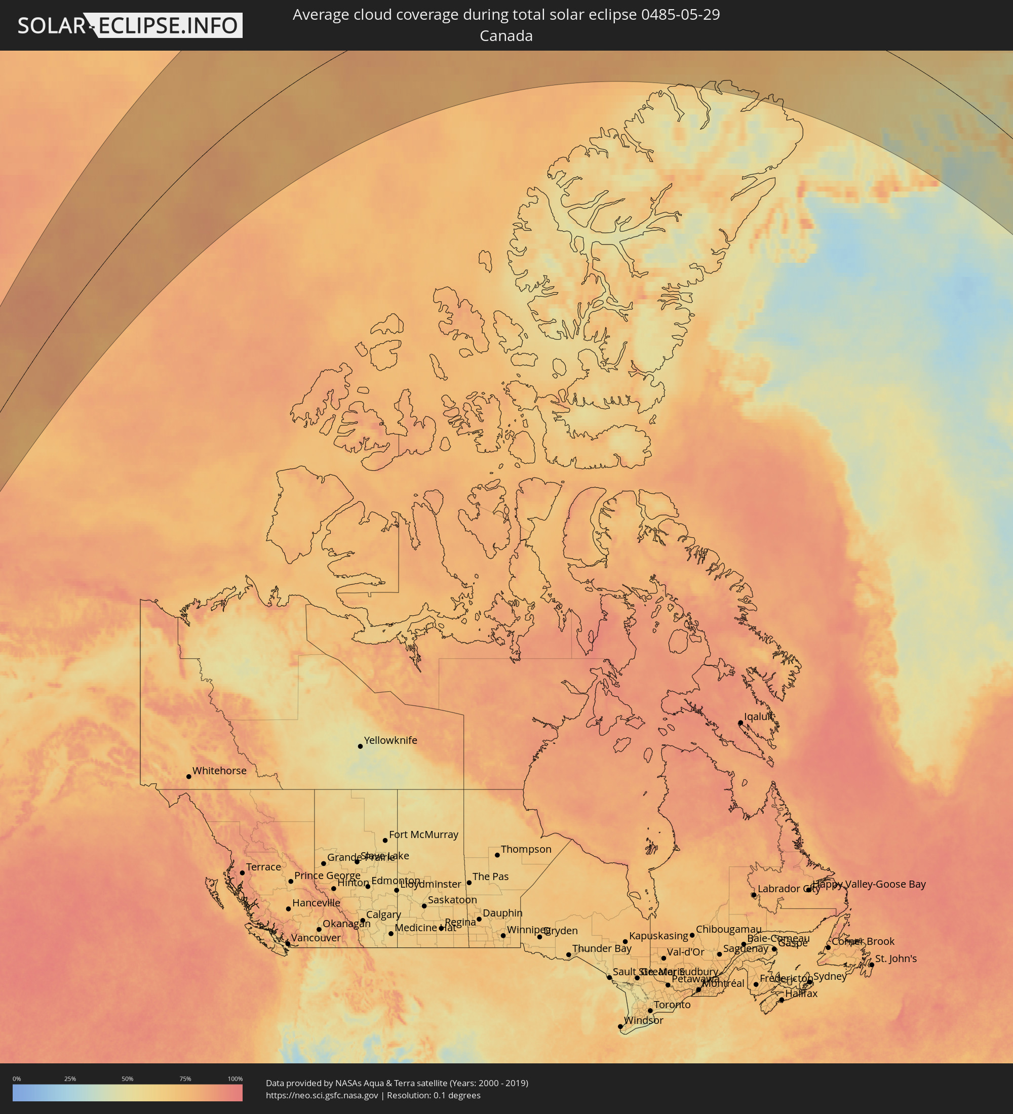 Kanada
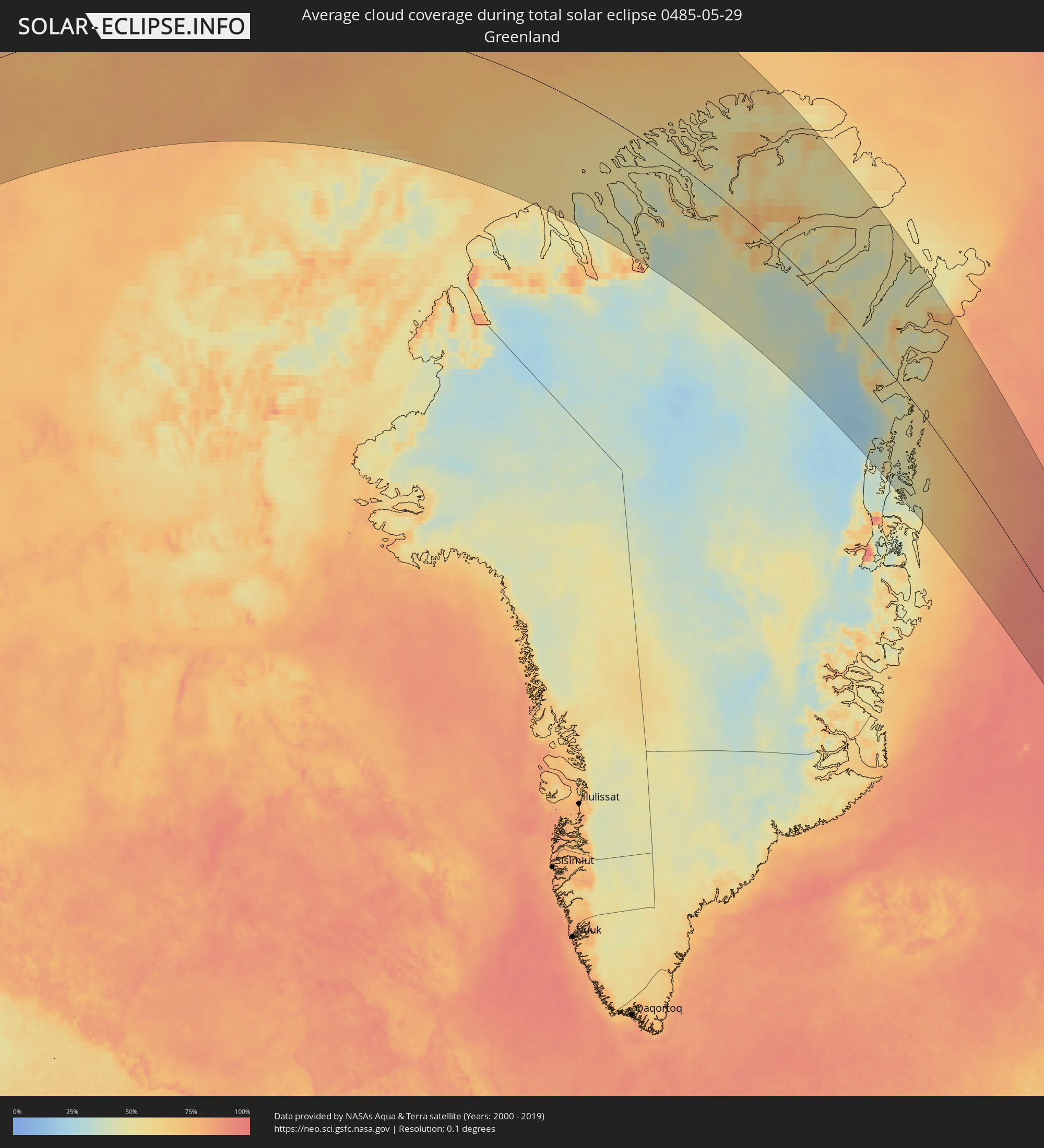 Grönland
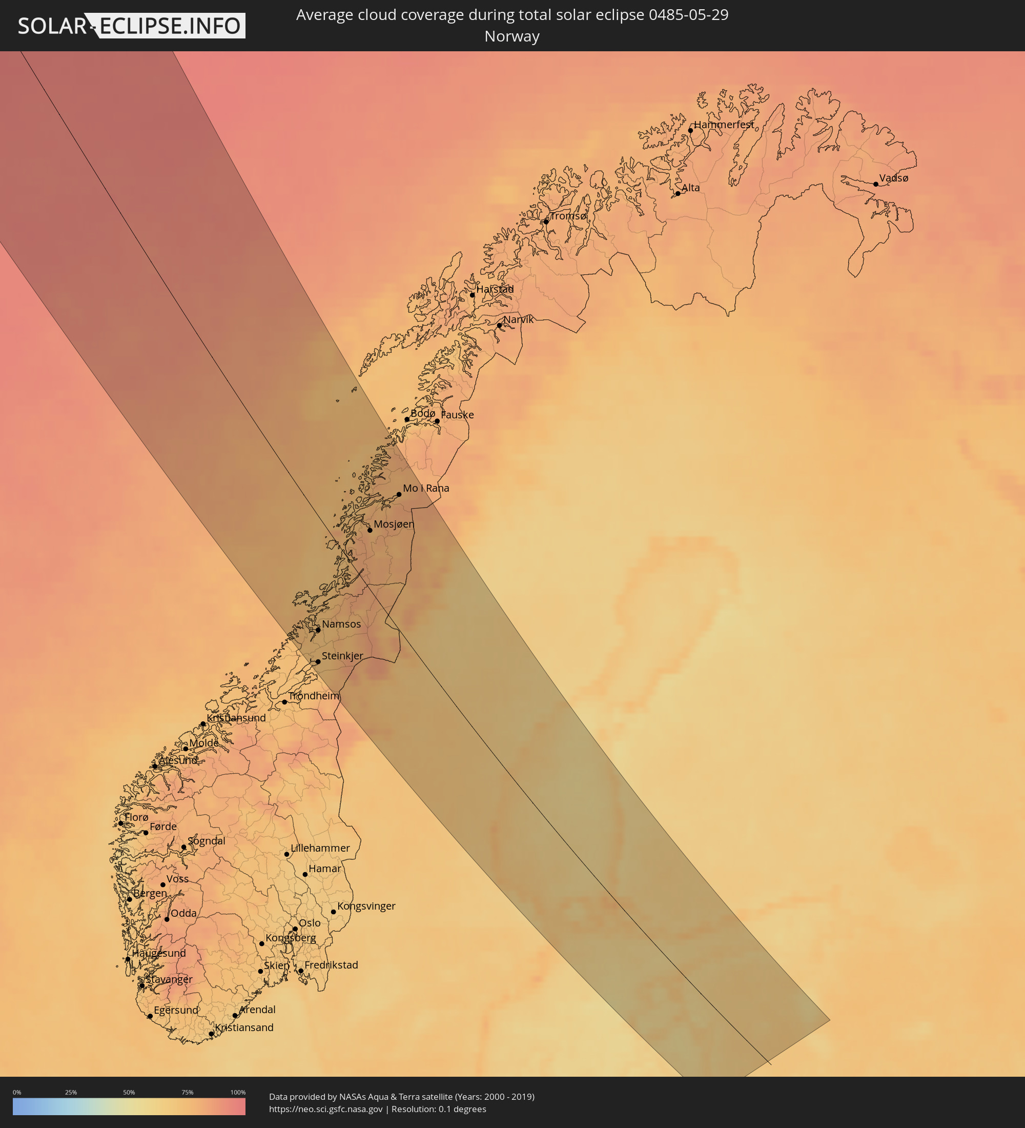 Norwegen
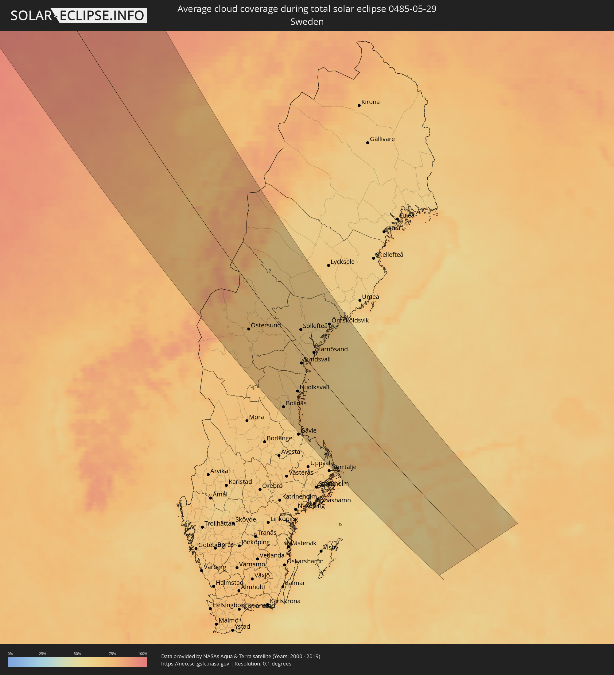 Schweden
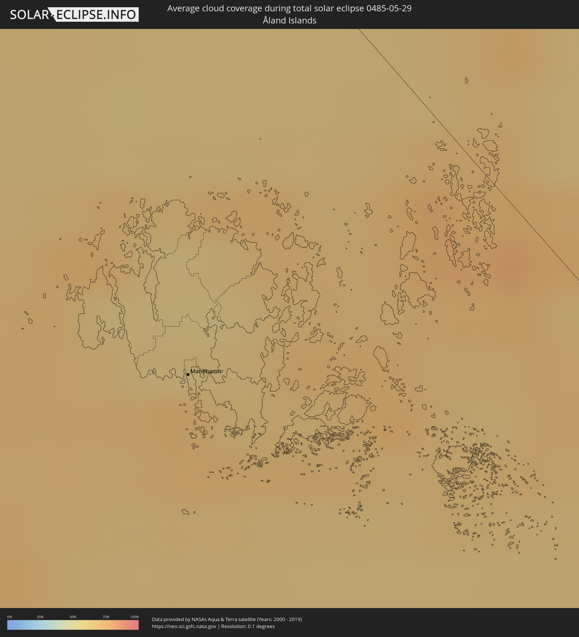 Åland Islands
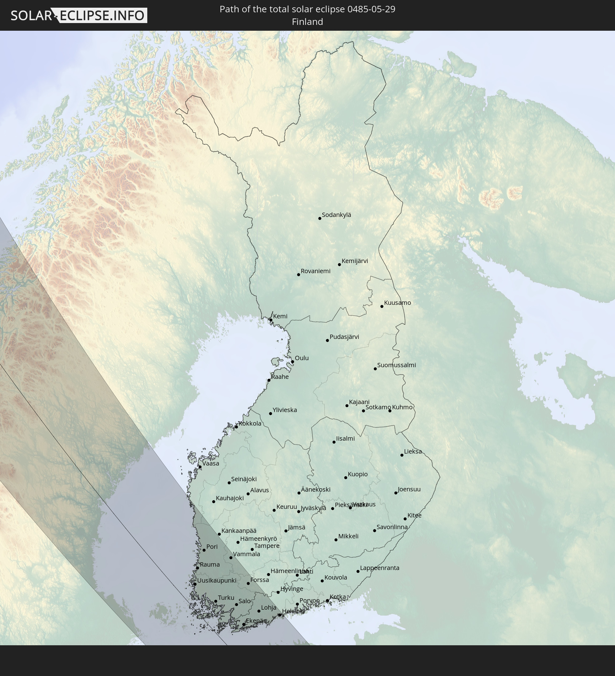
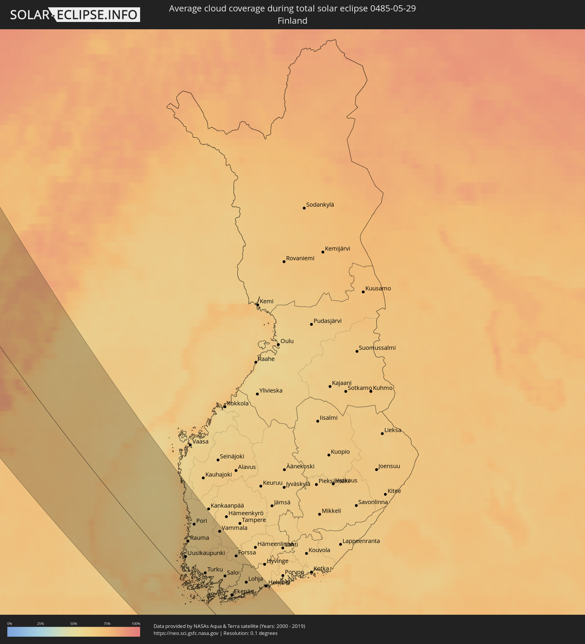 Finnland
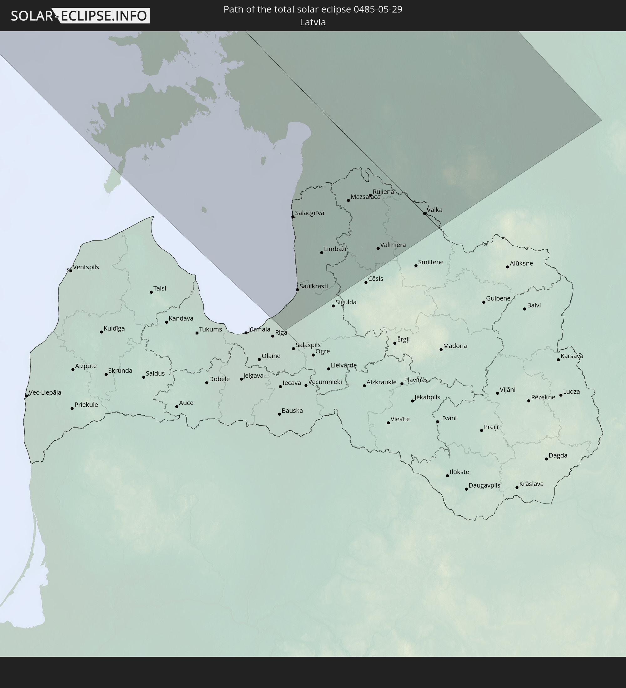
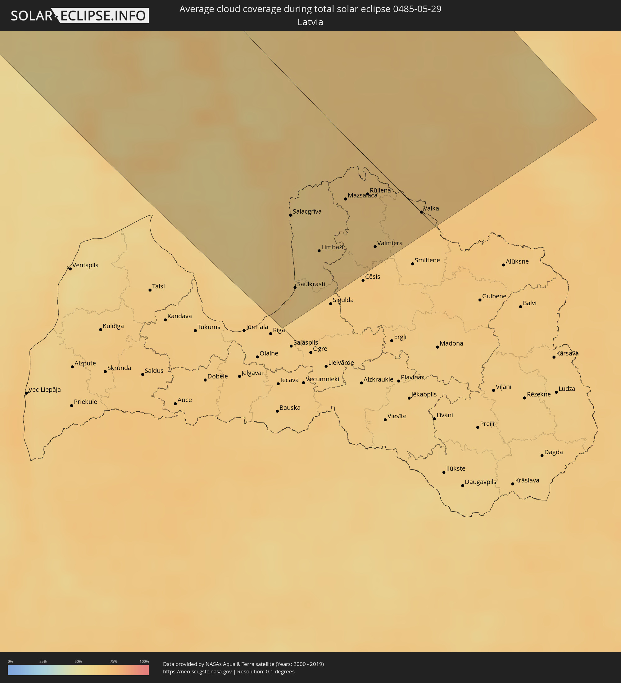 Lettland
 Estland
Orte im Finsternispfad
Die nachfolgene Tabelle zeigt Städte und Orte mit mehr als 5.000 Einwohnern, die sich im Finsternispfad befinden. Städte mit mehr als 100.000 Einwohnern sind dick gekennzeichnet. Mit einem Klick auf den Ort öffnet sich eine Detailkarte die die Lage des jeweiligen Ortes zusammen mit dem Verlauf der zentralen Finsternis präsentiert.
| Ort | Typ | Dauer der Verfinsterung | Ortszeit bei maximaler Verfinsterung | Entfernung zur Zentrallinie | Ø Bewölkung |
|
Steinkjer, Nord-Trøndelag
|
total | - | 19:45:41 UTC+01:00 | 134 km | 71% |
|
Namsos, Nord-Trøndelag
|
total | - | 19:45:02 UTC+01:00 | 104 km | 73% |
|
Sandnessjøen, Nordland
|
total | - | 19:42:29 UTC+01:00 | 43 km | 75% |
|
Mosjøen, Nordland
|
total | - | 19:42:35 UTC+01:00 | 55 km | 77% |
|
Mo i Rana, Nordland
|
total | - | 19:41:38 UTC+01:00 | 117 km | 78% |
|
Östersund, Jämtland
|
total | - | 19:45:47 UTC+01:00 | 70 km | 68% |
|
Ljusdal, Gävleborg
|
total | - | 19:47:01 UTC+01:00 | 105 km | 68% |
|
Bollnäs, Gävleborg
|
total | - | 19:47:31 UTC+01:00 | 128 km | 66% |
|
Söderhamn, Gävleborg
|
total | - | 19:47:18 UTC+01:00 | 103 km | 67% |
|
Hudiksvall, Gävleborg
|
total | - | 19:46:45 UTC+01:00 | 72 km | 69% |
|
Sollefteå, Västernorrland
|
total | - | 19:44:50 UTC+01:00 | 40 km | 64% |
|
Sundsvall, Västernorrland
|
total | - | 19:45:49 UTC+01:00 | 16 km | 65% |
|
Timrå, Västernorrland
|
total | - | 19:45:41 UTC+01:00 | 9 km | 65% |
|
Skutskär, Uppsala
|
total | - | 19:48:00 UTC+01:00 | 139 km | 64% |
|
Kramfors, Västernorrland
|
total | - | 19:44:56 UTC+01:00 | 42 km | 64% |
|
Härnösand, Västernorrland
|
total | - | 19:45:15 UTC+01:00 | 27 km | 67% |
|
Örnsköldsvik, Västernorrland
|
total | - | 19:44:07 UTC+01:00 | 103 km | 62% |
|
Mariehamn, Mariehamns stad
|
total | - | 20:27:22 UTC+01:39 | 74 km | 71% |
|
Kristinestad, Ostrobothnia
|
total | - | 20:24:06 UTC+01:39 | 142 km | 62% |
|
Uusikaupunki, Southwest Finland
|
total | - | 20:25:52 UTC+01:39 | 40 km | 62% |
|
Rauma, Satakunta
|
total | - | 20:25:26 UTC+01:39 | 67 km | 58% |
|
Laitila, Southwest Finland
|
total | - | 20:25:38 UTC+01:39 | 56 km | 61% |
|
Pori, Satakunta
|
total | - | 20:24:53 UTC+01:39 | 104 km | 59% |
|
Ulvila, Satakunta
|
total | - | 20:24:54 UTC+01:39 | 103 km | 61% |
|
Naantali, Southwest Finland
|
total | - | 20:25:58 UTC+01:39 | 40 km | 63% |
|
Harjavalta, Satakunta
|
total | - | 20:24:55 UTC+01:39 | 106 km | 63% |
|
Eura, Satakunta
|
total | - | 20:25:08 UTC+01:39 | 93 km | 63% |
|
Turku, Southwest Finland
|
total | - | 20:25:52 UTC+01:39 | 49 km | 63% |
|
Länsi-Turunmaa, Southwest Finland
|
total | - | 20:26:02 UTC+01:39 | 43 km | 62% |
|
Pargas, Southwest Finland
|
total | - | 20:26:02 UTC+01:39 | 44 km | 62% |
|
Kokemäki, Satakunta
|
total | - | 20:24:53 UTC+01:39 | 111 km | 63% |
|
Kuressaare, Saare
|
total | - | 20:27:28 UTC+01:39 | 110 km | 66% |
|
Paimio, Southwest Finland
|
total | - | 20:25:40 UTC+01:39 | 68 km | 64% |
|
Huittinen, Satakunta
|
total | - | 20:24:49 UTC+01:39 | 119 km | 64% |
|
Kärdla, Hiiumaa
|
total | - | 20:26:30 UTC+01:39 | 45 km | 58% |
|
Vammala, Pirkanmaa
|
total | - | 20:24:33 UTC+01:39 | 138 km | 63% |
|
Hanko, Uusimaa
|
total | - | 20:26:16 UTC+01:39 | 31 km | 64% |
|
Halikko, Southwest Finland
|
total | - | 20:25:33 UTC+01:39 | 79 km | 64% |
|
Salo, Southwest Finland
|
total | - | 20:25:33 UTC+01:39 | 80 km | 64% |
|
Ekenäs, Uusimaa
|
total | - | 20:25:52 UTC+01:39 | 62 km | 64% |
|
Somero, Southwest Finland
|
total | - | 20:25:05 UTC+01:39 | 113 km | 64% |
|
Haapsalu, Lääne
|
total | - | 20:26:10 UTC+01:39 | 20 km | 61% |
|
Forssa, Häme
|
total | - | 20:24:49 UTC+01:39 | 132 km | 63% |
|
Karis, Uusimaa
|
total | - | 20:25:39 UTC+01:39 | 79 km | 62% |
|
Lohja, Uusimaa
|
total | - | 20:25:15 UTC+01:39 | 109 km | 64% |
|
Karkkila, Uusimaa
|
total | - | 20:24:51 UTC+01:39 | 135 km | 65% |
|
Carnikava, Carnikava
|
total | - | 20:25:19 UTC+01:36 | 125 km | 63% |
|
Vihti, Uusimaa
|
total | - | 20:24:56 UTC+01:39 | 131 km | 64% |
|
Ādaži, Ādaži
|
total | - | 20:25:21 UTC+01:36 | 127 km | 63% |
|
Salacgrīva, Salacgrīvas
|
total | - | 20:24:37 UTC+01:36 | 73 km | 59% |
|
Keila, Harjumaa
|
total | - | 20:25:19 UTC+01:39 | 56 km | 62% |
|
Saulkrasti, Saulkrastu
|
total | - | 20:25:07 UTC+01:36 | 108 km | 63% |
|
Pärnu, Pärnumaa
|
total | - | 20:26:17 UTC+01:39 | 21 km | 63% |
|
Saue, Harjumaa
|
total | - | 20:25:14 UTC+01:39 | 61 km | 63% |
|
Loja, Sēja
|
total | - | 20:25:06 UTC+01:36 | 107 km | 64% |
|
Espoo, Uusimaa
|
total | - | 20:25:01 UTC+01:39 | 129 km | 67% |
|
Ragana, Krimulda
|
total | - | 20:25:02 UTC+01:36 | 102 km | 65% |
|
Limbaži, Limbažu Rajons
|
total | - | 20:24:41 UTC+01:36 | 75 km | 62% |
|
Kauniainen, Uusimaa
|
total | - | 20:24:58 UTC+01:39 | 133 km | 67% |
|
Tallinn, Harjumaa
|
total | - | 20:25:00 UTC+01:39 | 78 km | 62% |
|
Rapla, Raplamaa
|
total | - | 20:25:27 UTC+01:39 | 49 km | 65% |
|
Aloja, Aloja
|
total | - | 20:24:19 UTC+01:36 | 48 km | 64% |
|
Helsinki, Uusimaa
|
total | - | 20:24:55 UTC+01:39 | 139 km | 71% |
|
Maardu, Harjumaa
|
total | - | 20:24:49 UTC+01:39 | 91 km | 61% |
|
Stalbe, Pārgaujas
|
total | - | 20:24:40 UTC+01:36 | 74 km | 66% |
|
Mazsalaca, Mazsalaca
|
total | - | 20:24:07 UTC+01:36 | 33 km | 65% |
|
Matīši, Burtnieki
|
total | - | 20:24:15 UTC+01:36 | 43 km | 63% |
|
Rūjiena, Rūjienas
|
total | - | 20:23:56 UTC+01:36 | 19 km | 66% |
|
Kocēni, Kocēni
|
total | - | 20:24:20 UTC+01:36 | 49 km | 67% |
|
Valmiera, Valmieras Rajons
|
total | - | 20:24:16 UTC+01:36 | 43 km | 67% |
|
Türi, Järvamaa
|
total | - | 20:25:20 UTC+01:39 | 60 km | 64% |
|
Naukšēni, Naukšēni
|
total | - | 20:23:53 UTC+01:36 | 18 km | 65% |
|
Murmuiža, Beverīna
|
total | - | 20:24:18 UTC+01:36 | 45 km | 66% |
|
Paide, Järvamaa
|
total | - | 20:25:12 UTC+01:39 | 70 km | 66% |
|
Viljandi, Viljandimaa
|
total | - | 20:25:44 UTC+01:39 | 35 km | 66% |
|
Strenči, Strenči
|
total | - | 20:24:02 UTC+01:36 | 25 km | 65% |
|
Tapa, Lääne-Virumaa
|
total | - | 20:24:35 UTC+01:39 | 113 km | 64% |
|
Valka, Valkas Rajons
|
total | - | 20:23:42 UTC+01:36 | 1 km | 67% |
|
Valga, Valgamaa
|
total | - | 20:26:07 UTC+01:39 | 3 km | 67% |
|
Rakvere, Lääne-Virumaa
|
total | - | 20:24:17 UTC+01:39 | 137 km | 64% |
|
Jõgeva, Jõgevamaa
|
total | - | 20:24:54 UTC+01:39 | 94 km | 65% |
|
Elva, Tartu
|
total | - | 20:25:27 UTC+01:39 | 55 km | 67% |
|
Tartu, Tartu
|
total | - | 20:25:07 UTC+01:39 | 79 km | 68% |
|
Põlva, Põlvamaa
|
total | - | 20:25:16 UTC+01:39 | 67 km | 68% |
|
Anadyr, Chukotskiy Avtonomnyy Okrug
|
total | - | 05:08:51 UTC+11:49 | 142 km | 79% |