Totale Sonnenfinsternis vom 04.01.0493
| Wochentag: | Sonntag |
| Maximale Dauer der Verfinsterung: | 03m16s |
| Maximale Breite des Finsternispfades: | 128 km |
| Saroszyklus: | 78 |
| Bedeckungsgrad: | 100% |
| Magnitude: | 1.0326 |
| Gamma: | 0.5104 |
Wo kann man die Sonnenfinsternis vom 04.01.0493 sehen?
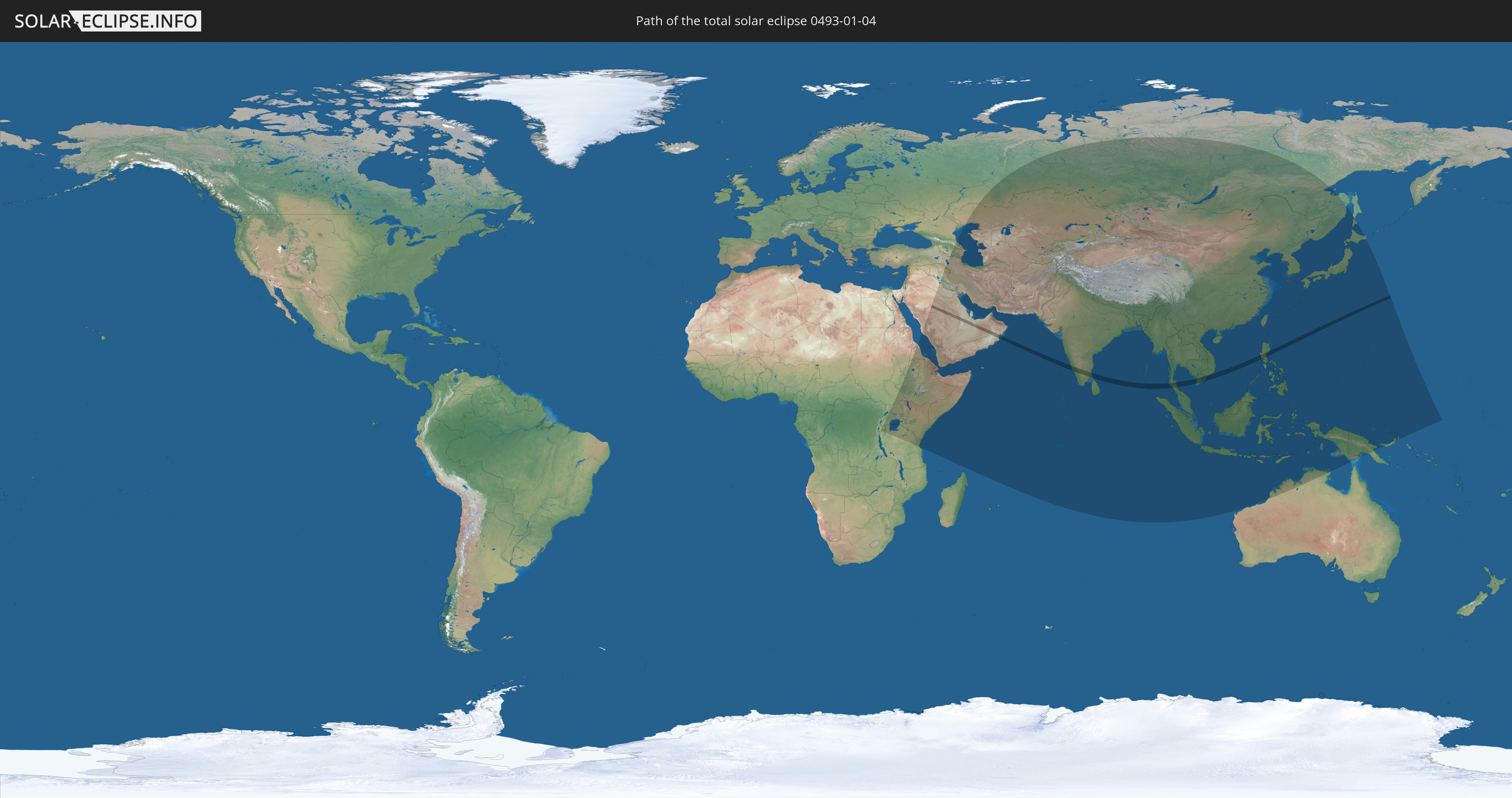
Die Sonnenfinsternis am 04.01.0493 kann man in 65 Ländern als partielle Sonnenfinsternis beobachten.
Der Finsternispfad verläuft durch 7 Länder. Nur in diesen Ländern ist sie als totale Sonnenfinsternis zu sehen.
In den folgenden Ländern ist die Sonnenfinsternis total zu sehen
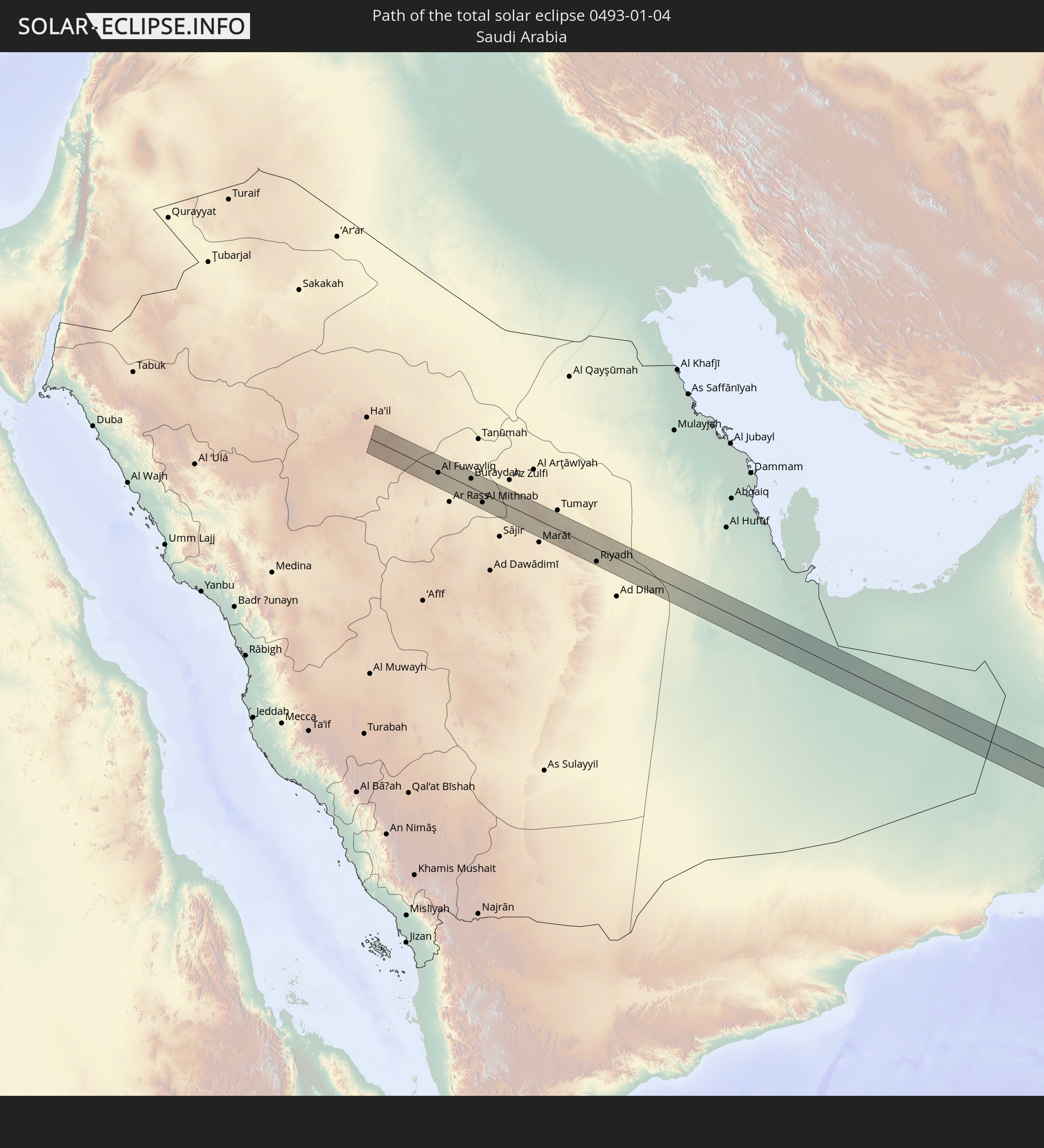 Saudi-Arabien
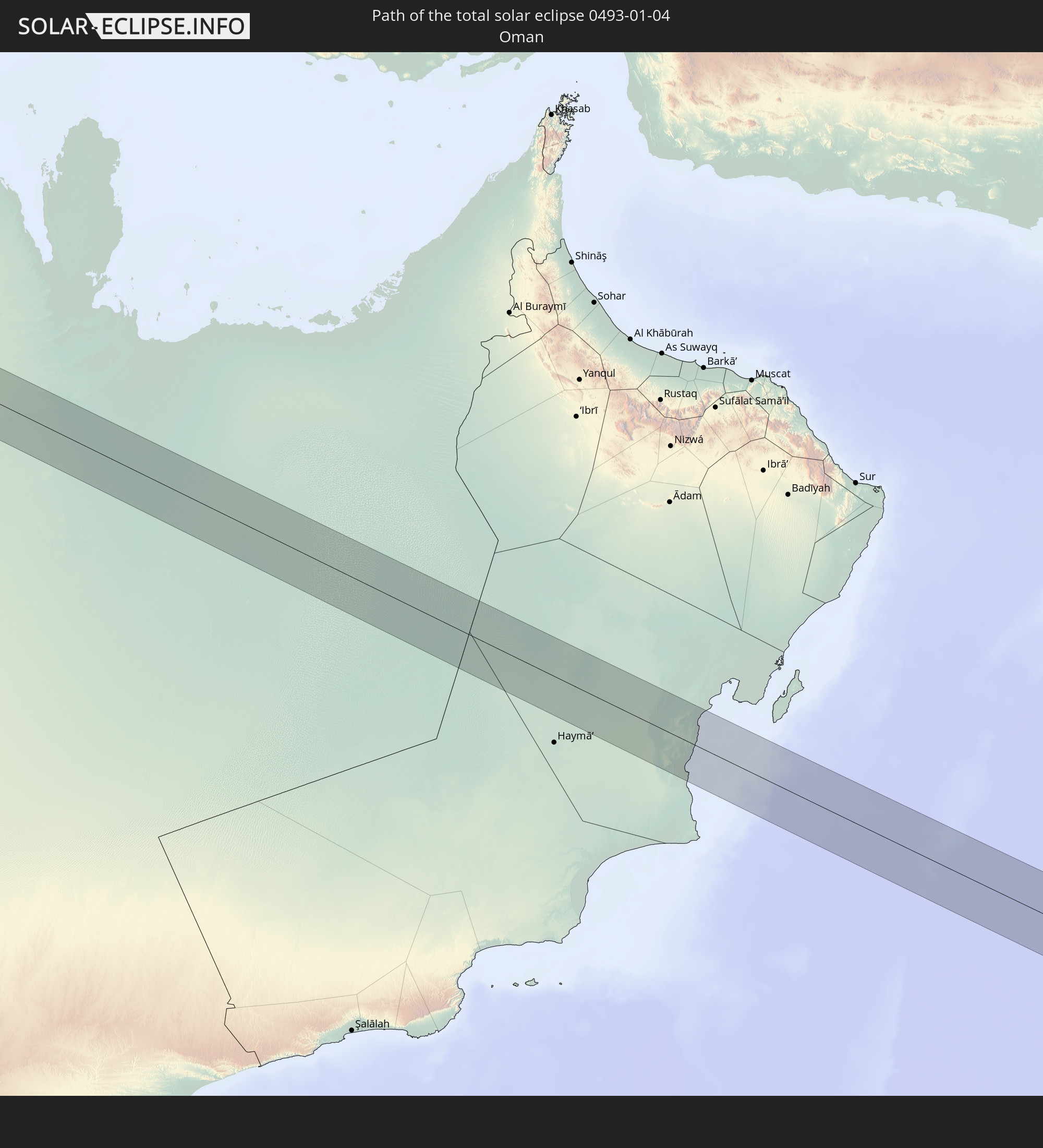 Oman
Oman
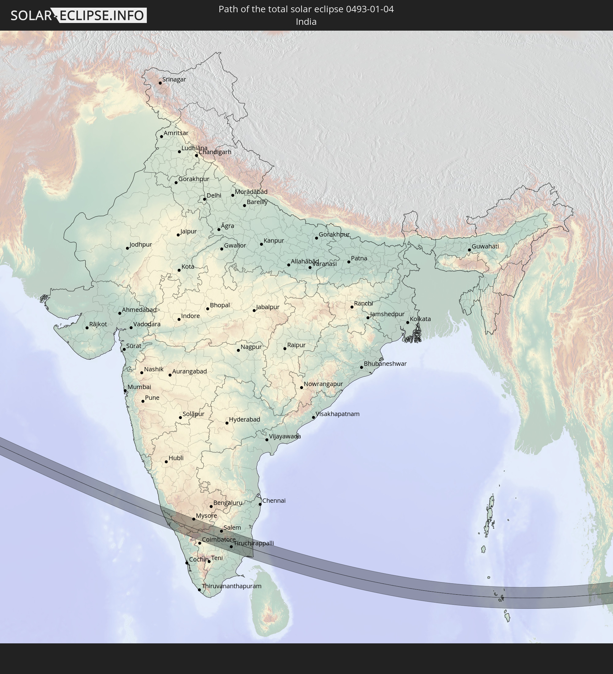 Indien
 Thailand
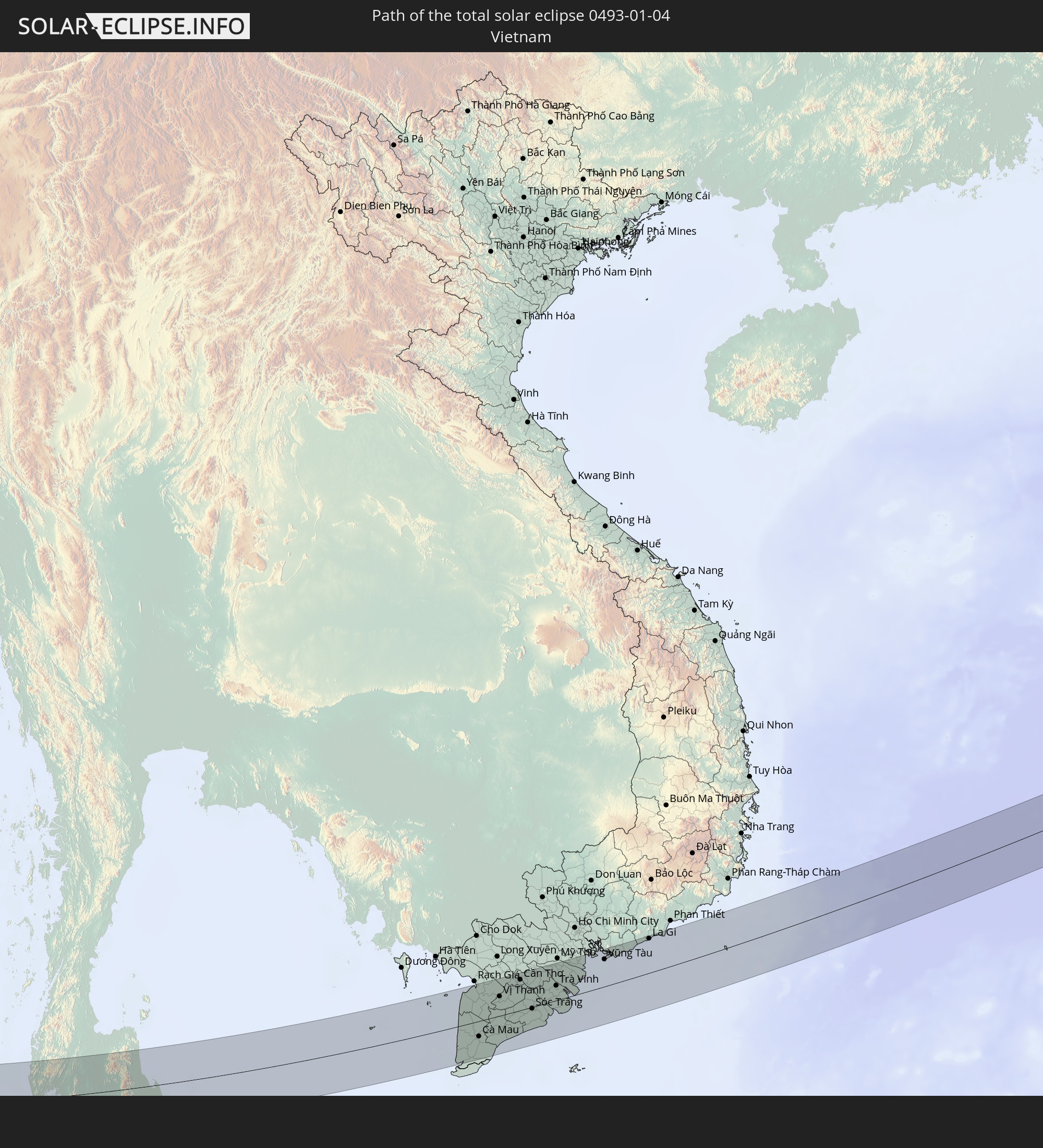 Vietnam
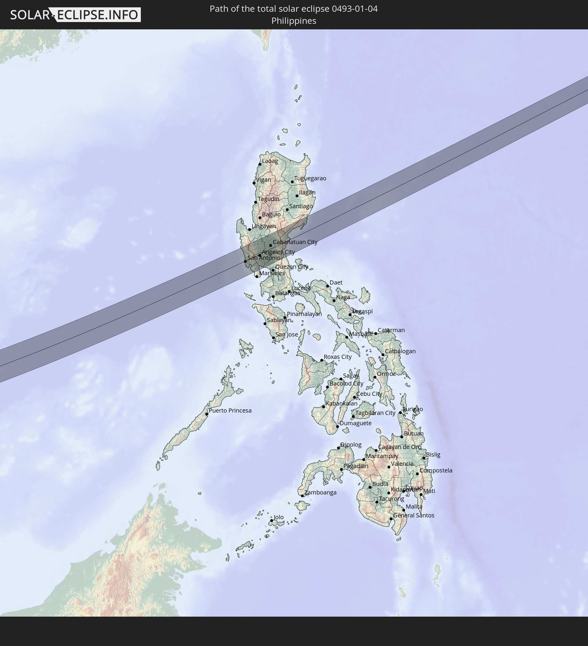 Philippinen
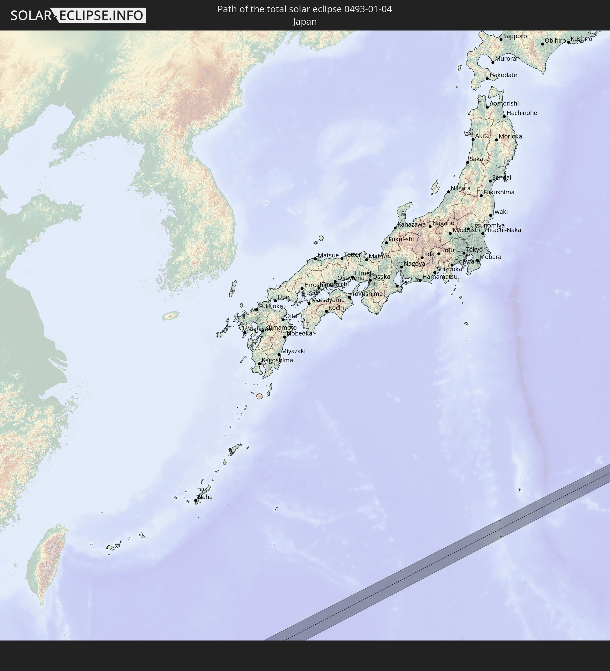 Japan
Japan
In den folgenden Ländern ist die Sonnenfinsternis partiell zu sehen
 Russland
 Sudan
Sudan
 Ruanda
 Burundi
 Tansania
 Uganda
 Äthiopien
 Kenia
Kenia
 Saudi-Arabien
 Eritrea
 Irak
Irak
 Somalia
 Dschibuti
 Jemen
Jemen
 Armenien
 Iran
Iran
 Aserbaidschan
 Seychellen
 Kasachstan
 Kuwait
 Bahrain
 Katar
Katar
 Vereinigte Arabische Emirate
 Oman
Oman
 Turkmenistan
 Usbekistan
 Mauritius
 Afghanistan
 Pakistan
 Tadschikistan
 Indien
 Kirgisistan
 Britisches Territorium im Indischen Ozean
 Malediven
 Volksrepublik China
 Sri Lanka
 Nepal
Nepal
 Mongolei
 Bangladesch
 Bhutan
 Myanmar
 Indonesien
 Kokosinseln
 Thailand
 Malaysia
 Laos
Laos
 Vietnam
 Kambodscha
 Singapur
 Weihnachtsinsel
 Australien
 Macau
Macau
 Hongkong
 Brunei
 Taiwan
 Philippinen
 Japan
Japan
 Osttimor
 Nordkorea
 Südkorea
 Palau
Palau
 Föderierte Staaten von Mikronesien
 Papua-Neuguinea
 Guam
Guam
 Nördliche Marianen
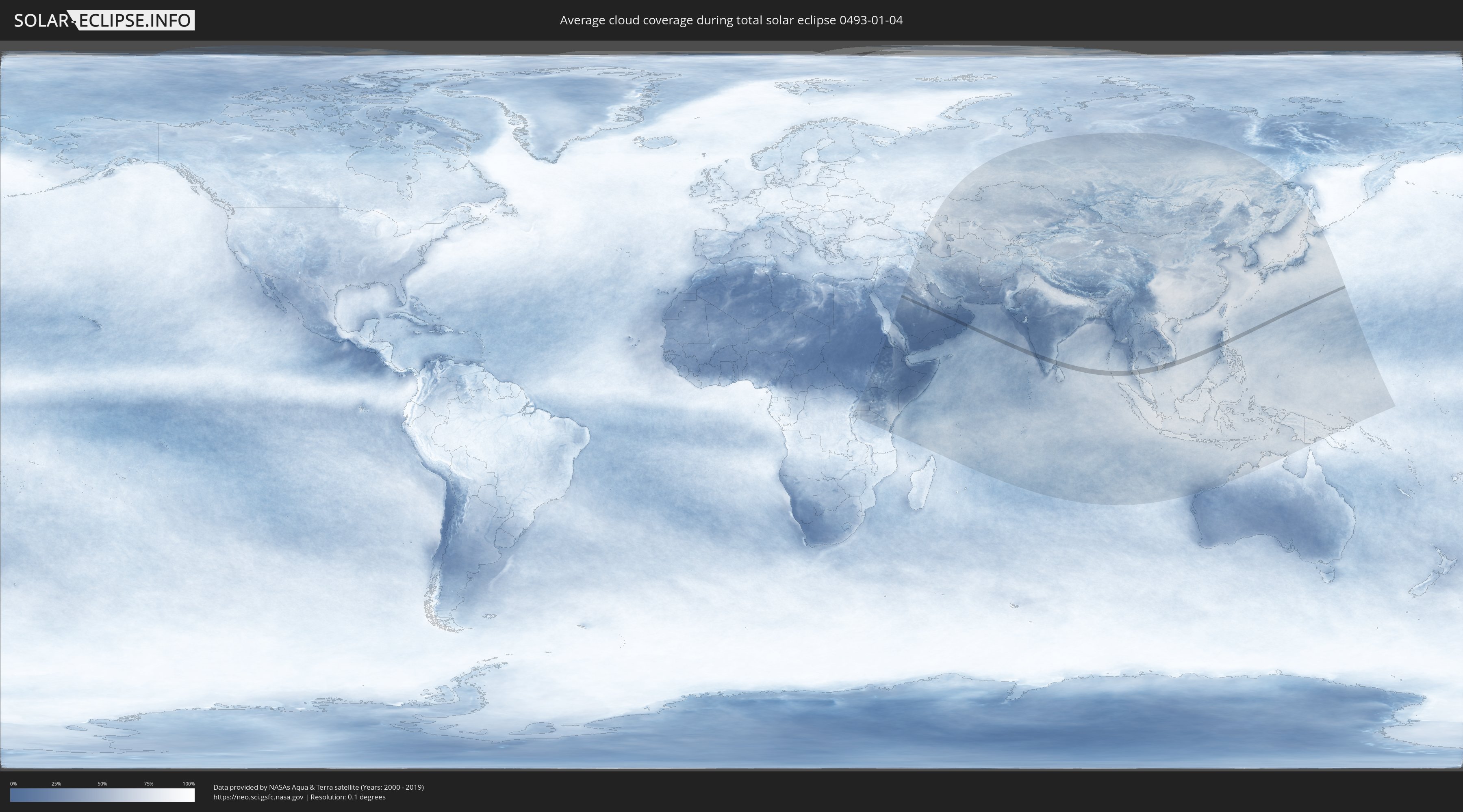
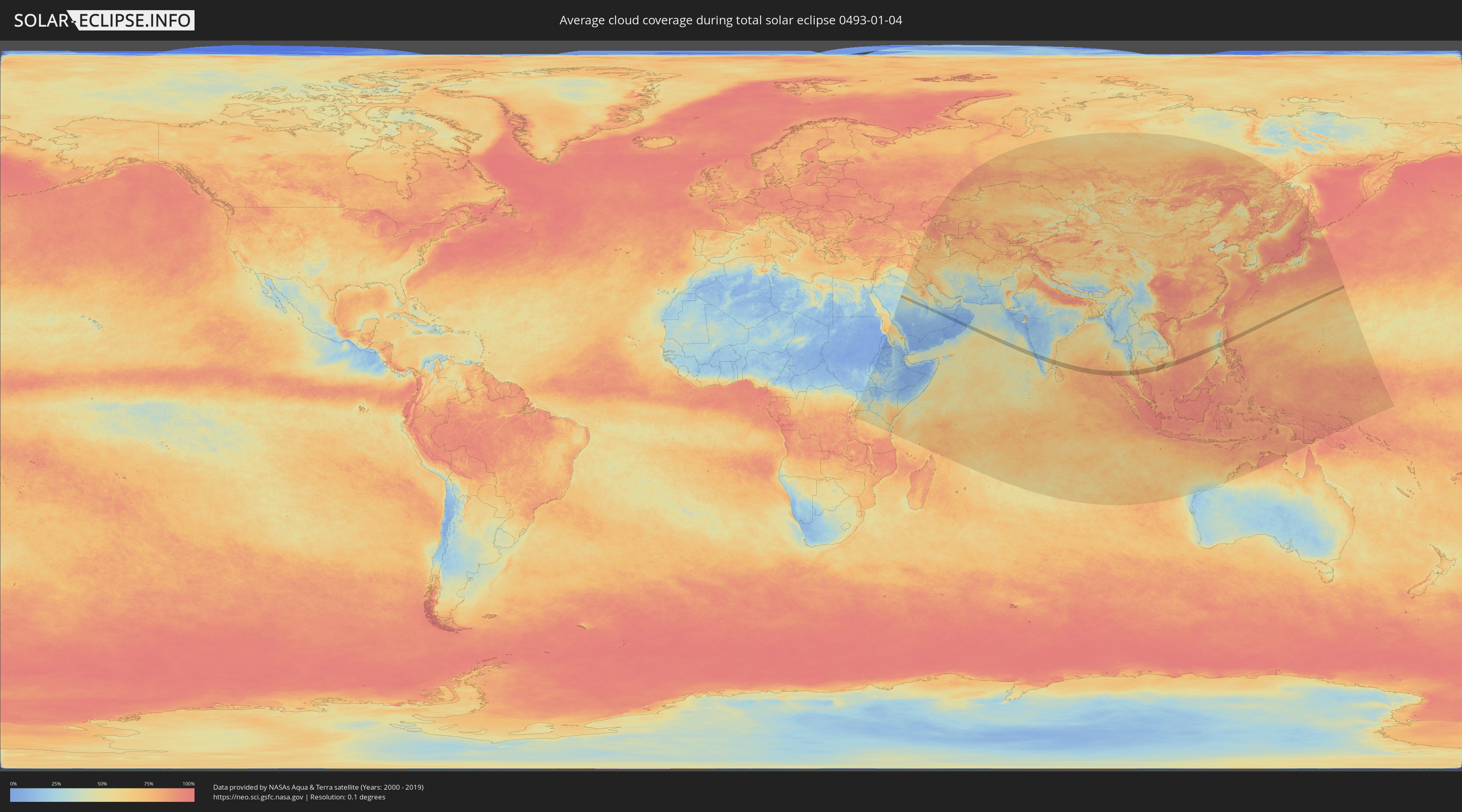
Wie wird das Wetter während der totalen Sonnenfinsternis am 04.01.0493?
Wo ist der beste Ort, um die totale Sonnenfinsternis vom 04.01.0493 zu beobachten?
Die folgenden Karten zeigen die durchschnittliche Bewölkung für den Tag, an dem die totale Sonnenfinsternis
stattfindet. Mit Hilfe der Karten lässt sich der Ort entlang des Finsternispfades eingrenzen,
der die besten Aussichen auf einen klaren wolkenfreien Himmel bietet.
Trotzdem muss man immer lokale Gegenenheiten beachten und sollte sich genau über das Wetter an seinem
gewählten Beobachtungsort informieren.
Die Daten stammen von den beiden NASA-Satelliten
AQUA und TERRA
und wurden über einen Zeitraum von 19 Jahren (2000 - 2019) gemittelt.
Detaillierte Länderkarten
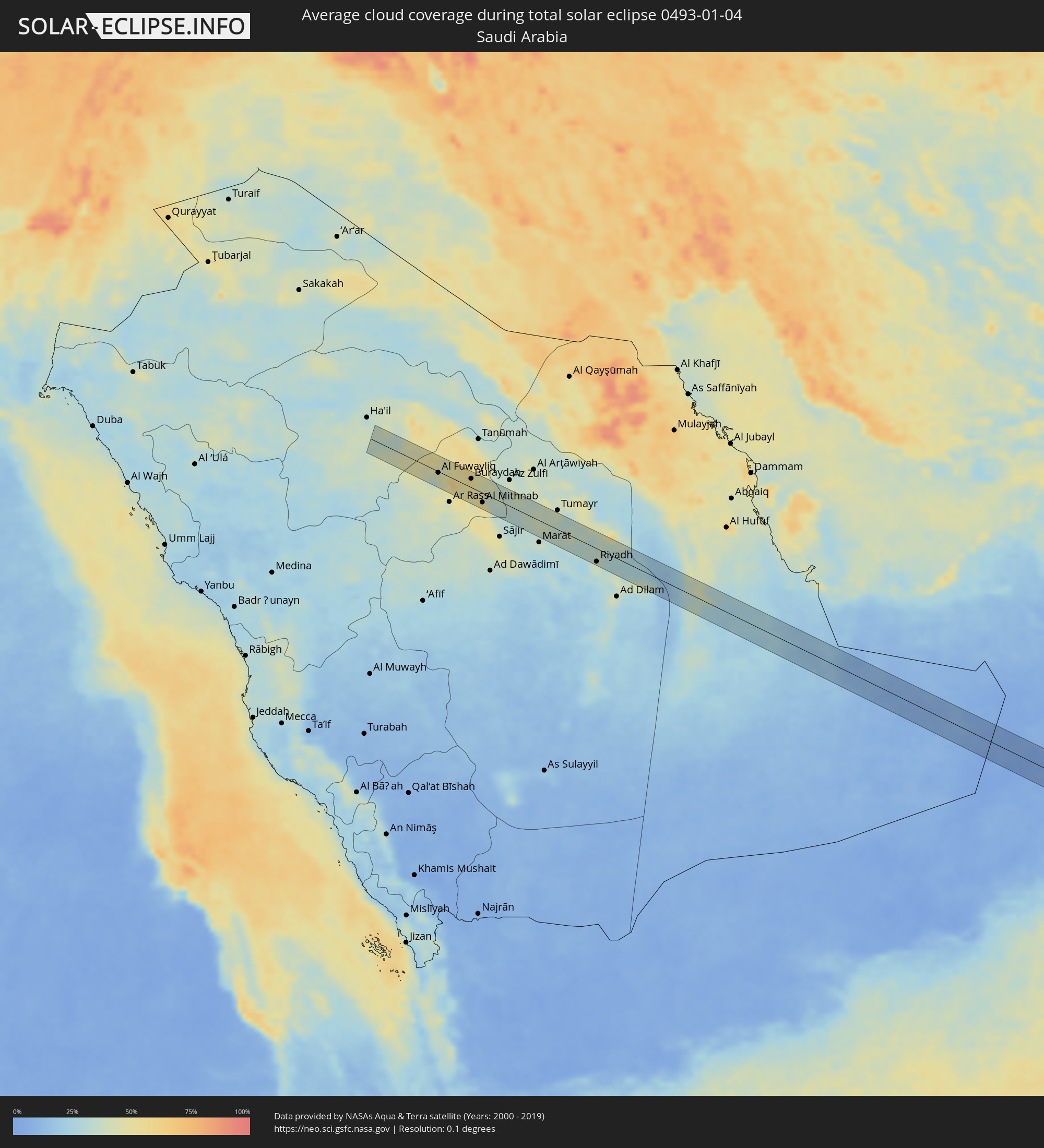 Saudi-Arabien
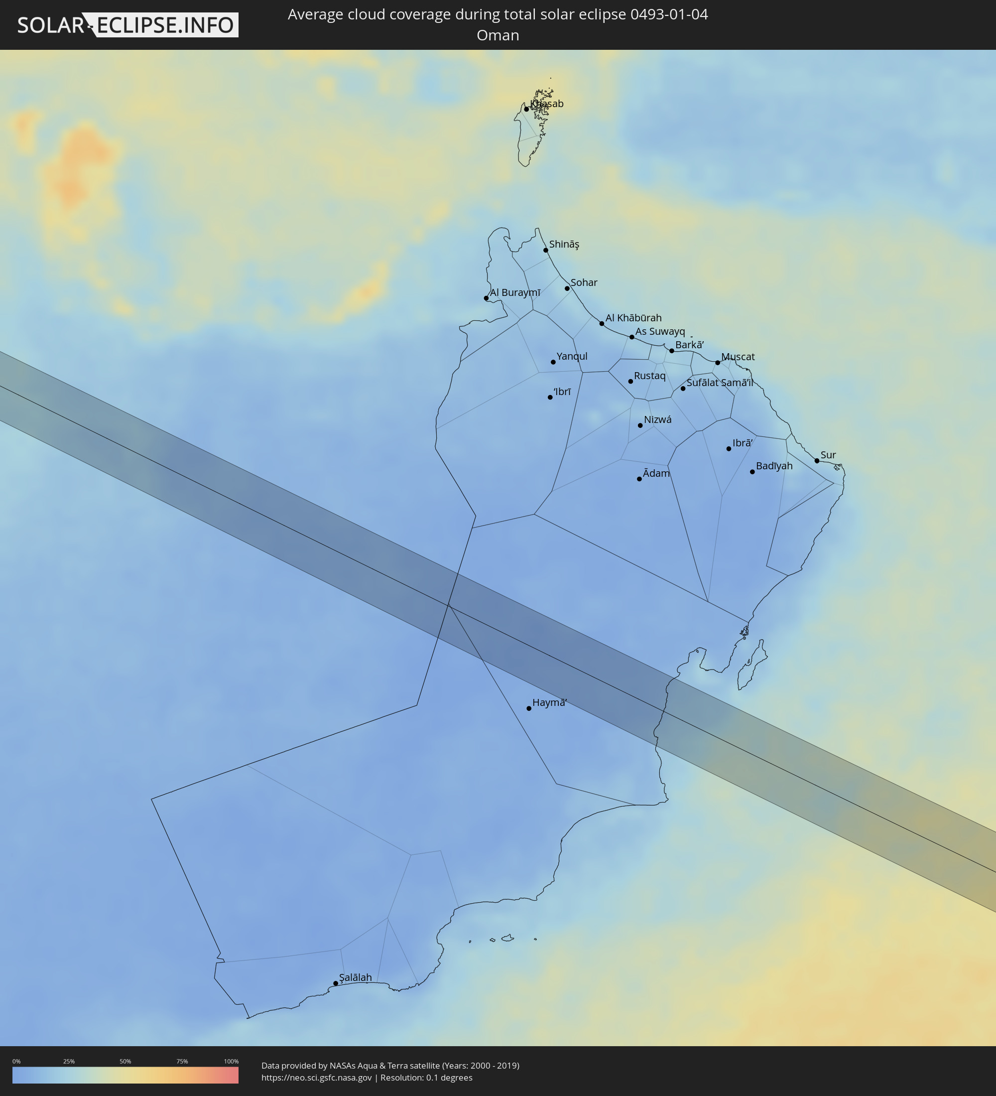 Oman
Oman
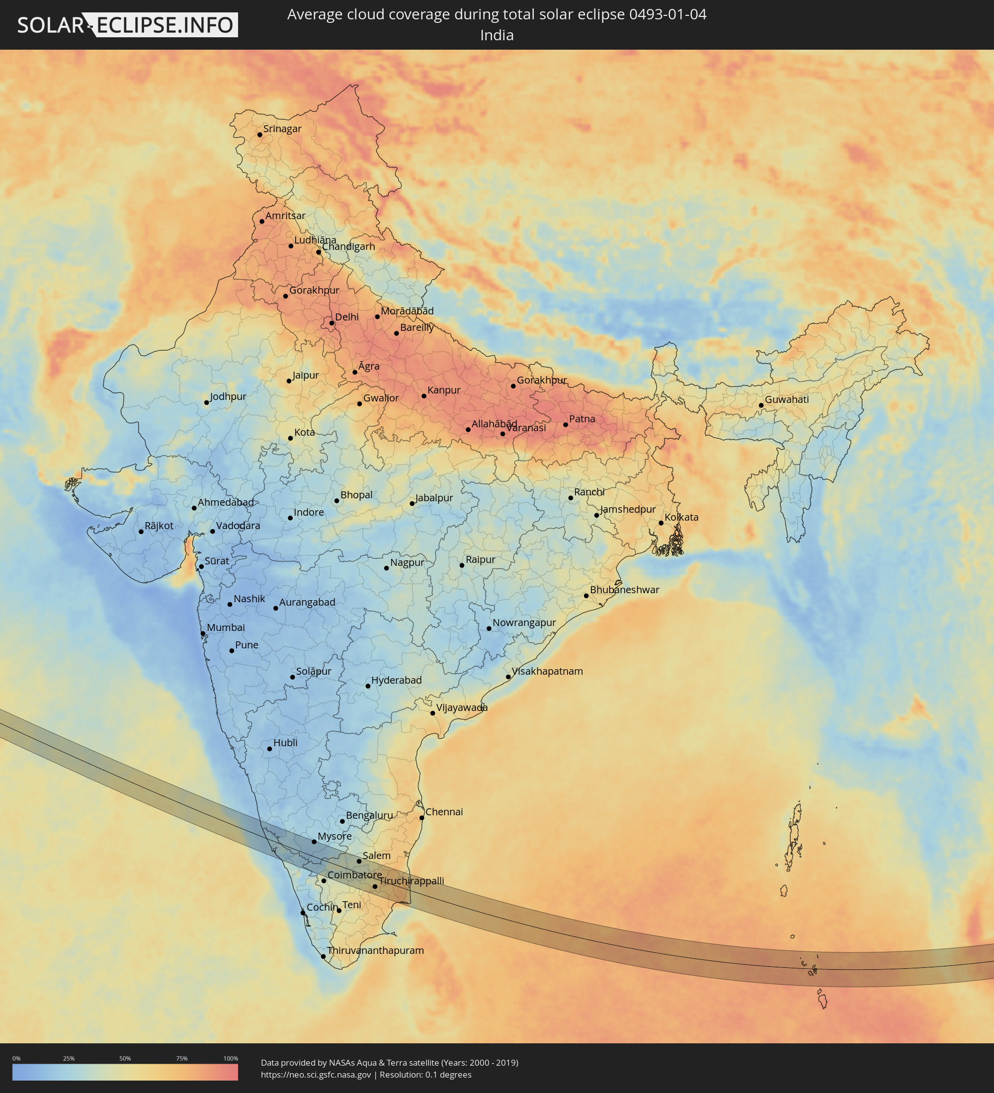 Indien
 Thailand
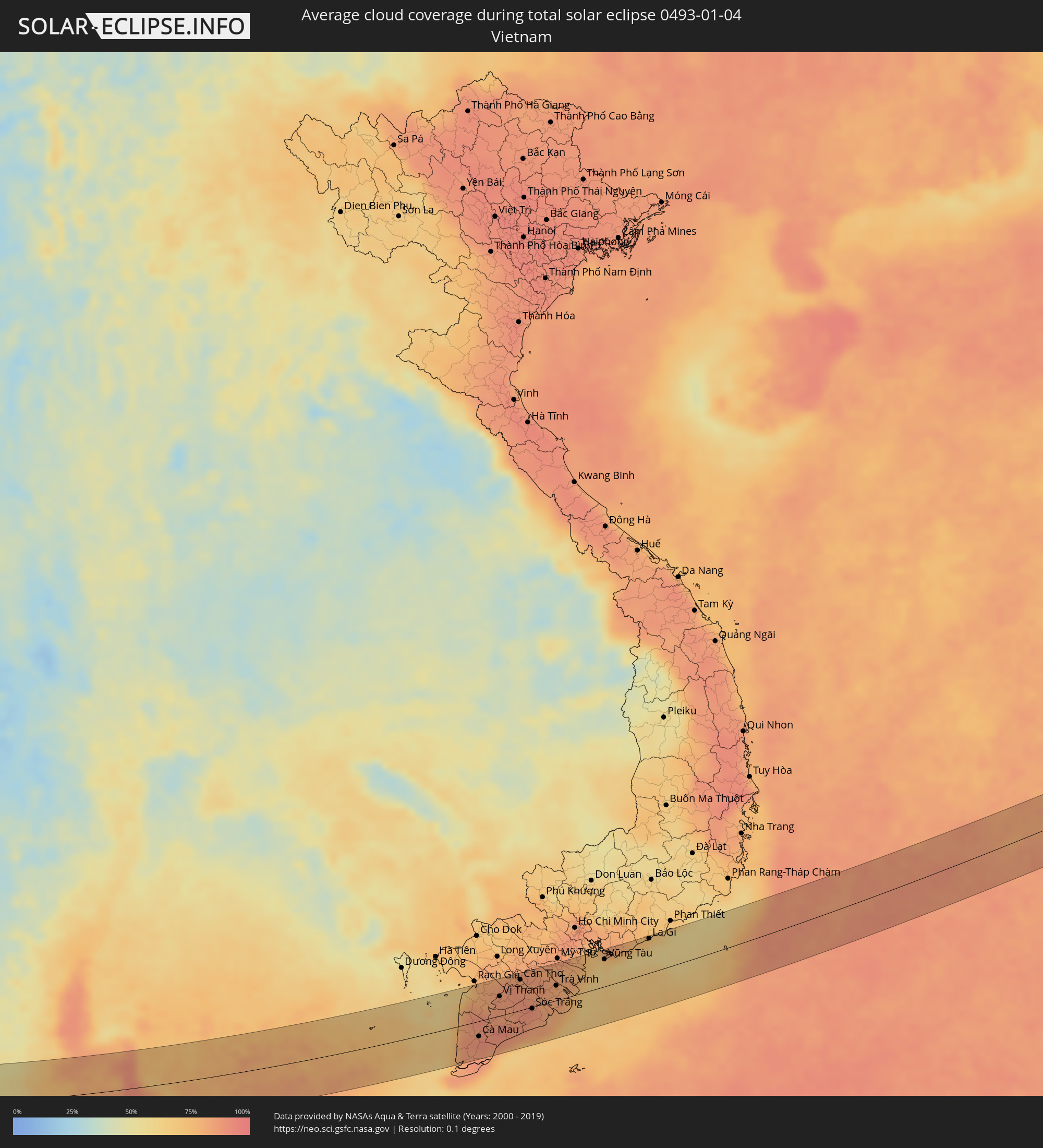 Vietnam
 Philippinen
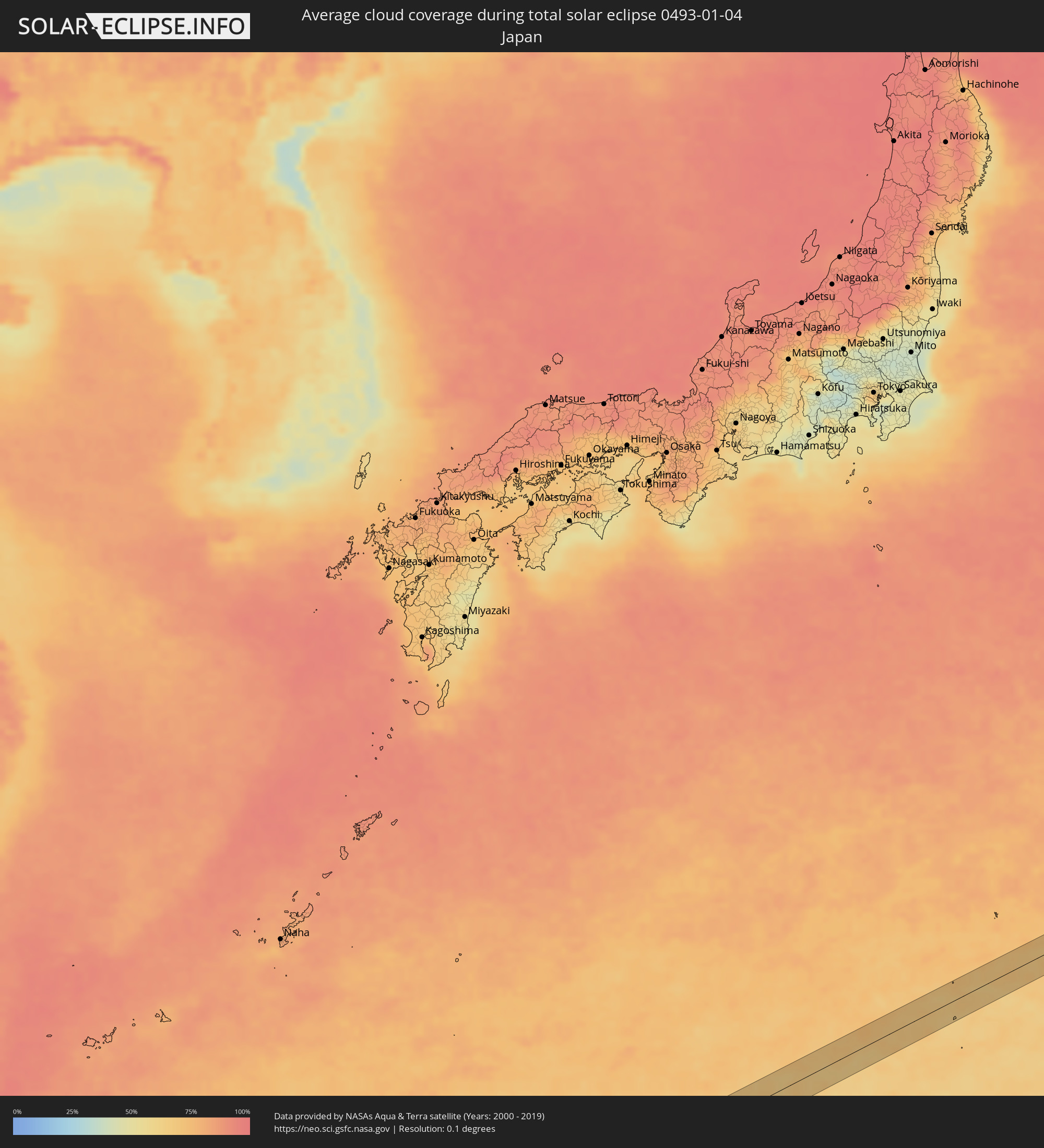 Japan
Japan
Orte im Finsternispfad
Die nachfolgene Tabelle zeigt Städte und Orte mit mehr als 5.000 Einwohnern, die sich im Finsternispfad befinden. Städte mit mehr als 100.000 Einwohnern sind dick gekennzeichnet. Mit einem Klick auf den Ort öffnet sich eine Detailkarte die die Lage des jeweiligen Ortes zusammen mit dem Verlauf der zentralen Finsternis präsentiert.
| Ort | Typ | Dauer der Verfinsterung | Ortszeit bei maximaler Verfinsterung | Entfernung zur Zentrallinie | Ø Bewölkung |
|
Al Fuwayliq, Al-Qassim
|
total | - | 07:18:43 UTC+03:06 | 3 km | 40% |
|
Al Bukayrīyah, Al-Qassim
|
total | - | 07:18:40 UTC+03:06 | 15 km | 50% |
|
Buraydah, Al-Qassim
|
total | - | 07:18:54 UTC+03:06 | 17 km | 50% |
|
Unaizah, Al-Qassim
|
total | - | 07:18:45 UTC+03:06 | 6 km | 52% |
|
Al Mithnab, Al-Qassim
|
total | - | 07:18:42 UTC+03:06 | 19 km | 54% |
|
Riyadh, Ar Riyāḑ
|
total | - | 07:19:01 UTC+03:06 | 26 km | 38% |
|
Mangalore, Karnataka
|
total | - | 10:02:07 UTC+05:21 | 44 km | 21% |
|
Kāsaragod, Kerala
|
total | - | 10:02:21 UTC+05:21 | 6 km | 20% |
|
Bantvāl, Karnataka
|
total | - | 10:02:29 UTC+05:21 | 48 km | 20% |
|
Kānnangād, Kerala
|
total | - | 10:02:35 UTC+05:21 | 9 km | 21% |
|
Puttūr, Karnataka
|
total | - | 10:02:49 UTC+05:21 | 41 km | 17% |
|
Payyannūr, Kerala
|
total | - | 10:02:47 UTC+05:21 | 28 km | 23% |
|
Cannanore, Kerala
|
total | - | 10:03:06 UTC+05:21 | 45 km | 18% |
|
Talipparamba, Kerala
|
total | - | 10:03:06 UTC+05:21 | 27 km | 19% |
|
Tellicherry, Kerala
|
total | - | 10:03:22 UTC+05:21 | 52 km | 18% |
|
Mattanūr, Kerala
|
total | - | 10:03:33 UTC+05:21 | 30 km | 28% |
|
Nādāpuram, Kerala
|
total | - | 10:03:43 UTC+05:21 | 52 km | 33% |
|
Madikeri, Karnataka
|
total | - | 10:03:56 UTC+05:21 | 28 km | 26% |
|
Hunsūr, Karnataka
|
total | - | 10:05:08 UTC+05:21 | 37 km | 19% |
|
Mysore, Karnataka
|
total | - | 10:05:54 UTC+05:21 | 50 km | 20% |
|
Nanjangūd, Karnataka
|
total | - | 10:05:59 UTC+05:21 | 33 km | 21% |
|
Ooty, Tamil Nadu
|
total | - | 10:05:59 UTC+05:21 | 40 km | 29% |
|
Mettupalayam, Tamil Nadu
|
total | - | 10:06:30 UTC+05:21 | 43 km | 39% |
|
Chamrajnagar, Karnataka
|
total | - | 10:06:33 UTC+05:21 | 22 km | 21% |
|
Kollegāl, Karnataka
|
total | - | 10:06:56 UTC+05:21 | 53 km | 23% |
|
Sathyamangalam, Tamil Nadu
|
total | - | 10:07:12 UTC+05:21 | 10 km | 31% |
|
Tiruppur, Tamil Nadu
|
total | - | 10:07:27 UTC+05:21 | 47 km | 44% |
|
Gobichettipalayam, Tamil Nadu
|
total | - | 10:07:40 UTC+05:21 | 8 km | 33% |
|
Erode, Tamil Nadu
|
total | - | 10:08:19 UTC+05:21 | 9 km | 40% |
|
Mettur, Tamil Nadu
|
total | - | 10:08:30 UTC+05:21 | 40 km | 39% |
|
Idappadi, Tamil Nadu
|
total | - | 10:08:35 UTC+05:21 | 20 km | 38% |
|
Tiruchengode, Tamil Nadu
|
total | - | 10:08:42 UTC+05:21 | 1 km | 42% |
|
Karur, Tamil Nadu
|
total | - | 10:09:07 UTC+05:21 | 37 km | 45% |
|
Salem, Tamil Nadu
|
total | - | 10:09:19 UTC+05:21 | 39 km | 40% |
|
Nāmakkal, Tamil Nadu
|
total | - | 10:09:19 UTC+05:21 | 6 km | 43% |
|
Rasipuram, Tamil Nadu
|
total | - | 10:09:23 UTC+05:21 | 20 km | 37% |
|
Attur, Tamil Nadu
|
total | - | 10:10:22 UTC+05:21 | 49 km | 46% |
|
Tiruchirappalli, Tamil Nadu
|
total | - | 10:10:34 UTC+05:21 | 29 km | 60% |
|
Thanjāvūr, Tamil Nadu
|
total | - | 10:11:38 UTC+05:21 | 17 km | 65% |
|
Pattukkottai, Tamil Nadu
|
total | - | 10:12:04 UTC+05:21 | 49 km | 71% |
|
Kumbakonam, Tamil Nadu
|
total | - | 10:12:15 UTC+05:21 | 10 km | 71% |
|
Mannargudi, Tamil Nadu
|
total | - | 10:12:23 UTC+05:21 | 19 km | 77% |
|
Thiruvarur, Tamil Nadu
|
total | - | 10:12:50 UTC+05:21 | 1 km | 78% |
|
Mayiladuthurai, Tamil Nadu
|
total | - | 10:12:54 UTC+05:21 | 35 km | 73% |
|
Kāraikāl, Pondicherry
|
total | - | 10:13:20 UTC+05:21 | 21 km | 64% |
|
Nāgappattinam, Tamil Nadu
|
total | - | 10:13:21 UTC+05:21 | 5 km | 64% |
|
Patong, Phuket
|
total | - | 12:29:57 UTC+06:42 | 36 km | 63% |
|
Ban Karon, Phuket
|
total | - | 12:29:57 UTC+06:42 | 42 km | 61% |
|
Rawai, Phuket
|
total | - | 12:30:02 UTC+06:42 | 50 km | 61% |
|
Kathu, Phuket
|
total | - | 12:30:04 UTC+06:42 | 34 km | 63% |
|
Ban Chalong, Phuket
|
total | - | 12:30:05 UTC+06:42 | 42 km | 61% |
|
Wichit, Phuket
|
total | - | 12:30:14 UTC+06:42 | 38 km | 64% |
|
Ban Talat Nua, Phuket
|
total | - | 12:30:14 UTC+06:42 | 38 km | 64% |
|
Ban Ko Kaeo, Phuket
|
total | - | 12:30:17 UTC+06:42 | 33 km | 64% |
|
Phuket, Phuket
|
total | - | 12:30:17 UTC+06:42 | 38 km | 64% |
|
Ban Talat Yai, Phuket
|
total | - | 12:30:17 UTC+06:42 | 39 km | 64% |
|
Ban Ratsada, Phuket
|
total | - | 12:30:18 UTC+06:42 | 36 km | 64% |
|
Phang Nga, Phangnga
|
total | - | 12:30:47 UTC+06:42 | 23 km | 72% |
|
Ban Phru Nai, Phangnga
|
total | - | 12:30:55 UTC+06:42 | 33 km | 58% |
|
Ao Luek, Krabi
|
total | - | 12:31:24 UTC+06:42 | 13 km | 69% |
|
Ban Ao Nang, Phangnga
|
total | - | 12:31:39 UTC+06:42 | 25 km | 69% |
|
Krabi, Krabi
|
total | - | 12:31:58 UTC+06:42 | 23 km | 77% |
|
Nuea Khlong, Krabi
|
total | - | 12:32:16 UTC+06:42 | 24 km | 77% |
|
Chai Buri, Surat Thani
|
total | - | 12:32:34 UTC+06:42 | 18 km | 79% |
|
Ban Na San, Surat Thani
|
total | - | 12:33:33 UTC+06:42 | 52 km | 81% |
|
Wiang Sa, Surat Thani
|
total | - | 12:33:32 UTC+06:42 | 33 km | 78% |
|
Tham Phannara, Nakhon Si Thammarat
|
total | - | 12:33:36 UTC+06:42 | 9 km | 78% |
|
Chawang, Nakhon Si Thammarat
|
total | - | 12:33:57 UTC+06:42 | 9 km | 78% |
|
Huai Yot, Trang
|
total | - | 12:34:17 UTC+06:42 | 64 km | 84% |
|
Thung Song, Nakhon Si Thammarat
|
total | - | 12:34:29 UTC+06:42 | 23 km | 85% |
|
Ron Phibun, Nakhon Si Thammarat
|
total | - | 12:35:03 UTC+06:42 | 24 km | 89% |
|
Nakhon Si Thammarat, Nakhon Si Thammarat
|
total | - | 12:35:27 UTC+06:42 | 3 km | 90% |
|
Pak Phanang, Nakhon Si Thammarat
|
total | - | 12:36:12 UTC+06:42 | 10 km | 83% |
|
Cà Mau, Cà Mau
|
total | - | 13:16:21 UTC+07:06 | 25 km | 90% |
|
Vị Thanh, Hau Giang
|
total | - | 13:17:24 UTC+07:06 | 32 km | 85% |
|
Thành phố Bạc Liêu, Bạc Liêu
|
total | - | 13:18:04 UTC+07:06 | 28 km | 85% |
|
Cần Thơ, Cần Thơ
|
total | - | 13:18:23 UTC+07:06 | 50 km | 86% |
|
Sóc Trăng, Sóc Trăng
|
total | - | 13:18:51 UTC+07:06 | 2 km | 85% |
|
Ấp Tân Ngãi, Bến Tre
|
total | - | 13:19:53 UTC+07:06 | 56 km | 84% |
|
Trà Vinh, Trà Vinh
|
total | - | 13:20:00 UTC+07:06 | 24 km | 81% |
|
Bến Tre, Bến Tre
|
total | - | 13:20:09 UTC+07:06 | 55 km | 81% |
|
Cần Giờ, Ho Chi Minh City
|
total | - | 13:21:51 UTC+07:06 | 55 km | 62% |
|
Vũng Tàu, Bà Rịa-Vũng Tàu
|
total | - | 13:22:12 UTC+07:06 | 44 km | 62% |
|
Thành Phố Bà Rịa, Bà Rịa-Vũng Tàu
|
total | - | 13:22:28 UTC+07:06 | 57 km | 73% |
|
La Gi, Bình Thuận
|
total | - | 13:24:13 UTC+07:06 | 55 km | 62% |
|
Iba, Central Luzon
|
total | - | 14:46:32 UTC+08:00 | 40 km | 49% |
|
San Antonio, Central Luzon
|
total | - | 14:46:45 UTC+08:00 | 4 km | 56% |
|
Morong, Central Luzon
|
total | - | 14:47:05 UTC+08:00 | 39 km | 51% |
|
Olongapo, Central Luzon
|
total | - | 14:47:07 UTC+08:00 | 24 km | 52% |
|
Mayantoc, Central Luzon
|
total | - | 14:47:16 UTC+08:00 | 51 km | 53% |
|
Santa Ignacia, Central Luzon
|
total | - | 14:47:23 UTC+08:00 | 48 km | 53% |
|
Dinalupihan, Central Luzon
|
total | - | 14:47:25 UTC+08:00 | 27 km | 61% |
|
Santiago, Central Luzon
|
total | - | 14:47:32 UTC+08:00 | 27 km | 61% |
|
Balanga, Central Luzon
|
total | - | 14:47:35 UTC+08:00 | 51 km | 57% |
|
Paniqui, Central Luzon
|
total | - | 14:47:38 UTC+08:00 | 46 km | 52% |
|
Angeles City, Central Luzon
|
total | - | 14:47:40 UTC+08:00 | 6 km | 70% |
|
Cut-cut Primero, Central Luzon
|
total | - | 14:47:39 UTC+08:00 | 27 km | 59% |
|
Capas, Central Luzon
|
total | - | 14:47:40 UTC+08:00 | 12 km | 63% |
|
Tarlac City, Central Luzon
|
total | - | 14:47:41 UTC+08:00 | 27 km | 59% |
|
Nampicuan, Central Luzon
|
total | - | 14:47:43 UTC+08:00 | 51 km | 52% |
|
Pura, Central Luzon
|
total | - | 14:47:46 UTC+08:00 | 39 km | 55% |
|
San Manuel, Central Luzon
|
total | - | 14:47:48 UTC+08:00 | 24 km | 55% |
|
Cauayan, Central Luzon
|
total | - | 14:47:49 UTC+08:00 | 10 km | 64% |
|
San Fernando, Central Luzon
|
total | - | 14:47:51 UTC+08:00 | 23 km | 67% |
|
San Vicente, Central Luzon
|
total | - | 14:47:58 UTC+08:00 | 34 km | 79% |
|
Licab, Central Luzon
|
total | - | 14:47:59 UTC+08:00 | 25 km | 55% |
|
Guimba, Central Luzon
|
total | - | 14:47:59 UTC+08:00 | 37 km | 52% |
|
Arayat, Central Luzon
|
total | - | 14:48:00 UTC+08:00 | 15 km | 58% |
|
Santa Barbara, Central Luzon
|
total | - | 14:48:02 UTC+08:00 | 8 km | 60% |
|
Malolos, Central Luzon
|
total | - | 14:48:04 UTC+08:00 | 47 km | 75% |
|
Talugtug, Central Luzon
|
total | - | 14:48:03 UTC+08:00 | 47 km | 55% |
|
San Vicente, Central Luzon
|
total | - | 14:48:05 UTC+08:00 | 10 km | 58% |
|
San Isidro, Central Luzon
|
total | - | 14:48:05 UTC+08:00 | 30 km | 67% |
|
Santo Rosario, Central Luzon
|
total | - | 14:48:09 UTC+08:00 | 31 km | 52% |
|
Bibiclat, Central Luzon
|
total | - | 14:48:09 UTC+08:00 | 19 km | 60% |
|
Santo Rosario, Central Luzon
|
total | - | 14:48:12 UTC+08:00 | 8 km | 65% |
|
Baliuag, Central Luzon
|
total | - | 14:48:14 UTC+08:00 | 40 km | 71% |
|
Muñoz, Central Luzon
|
total | - | 14:48:13 UTC+08:00 | 36 km | 48% |
|
Gapan, Central Luzon
|
total | - | 14:48:19 UTC+08:00 | 7 km | 62% |
|
Cabanatuan City, Central Luzon
|
total | - | 14:48:21 UTC+08:00 | 10 km | 69% |
|
San Miguel, Central Luzon
|
total | - | 14:48:22 UTC+08:00 | 25 km | 68% |
|
Pantabangan, Central Luzon
|
total | - | 14:48:39 UTC+08:00 | 35 km | 47% |
|
Bongabon, Central Luzon
|
total | - | 14:48:39 UTC+08:00 | 17 km | 62% |
|
Dingalan, Central Luzon
|
total | - | 14:49:06 UTC+08:00 | 19 km | 76% |
|
Maria Aurora, Central Luzon
|
total | - | 14:49:14 UTC+08:00 | 18 km | 78% |