Totale Sonnenfinsternis vom 12.08.0603
| Wochentag: | Freitag |
| Maximale Dauer der Verfinsterung: | 04m33s |
| Maximale Breite des Finsternispfades: | 301 km |
| Saroszyklus: | 103 |
| Bedeckungsgrad: | 100% |
| Magnitude: | 1.0671 |
| Gamma: | 0.686 |
Wo kann man die Sonnenfinsternis vom 12.08.0603 sehen?

Die Sonnenfinsternis am 12.08.0603 kann man in 96 Ländern als partielle Sonnenfinsternis beobachten.
Der Finsternispfad verläuft durch 12 Länder. Nur in diesen Ländern ist sie als totale Sonnenfinsternis zu sehen.
In den folgenden Ländern ist die Sonnenfinsternis total zu sehen
 Vereinigte Staaten
 Kanada
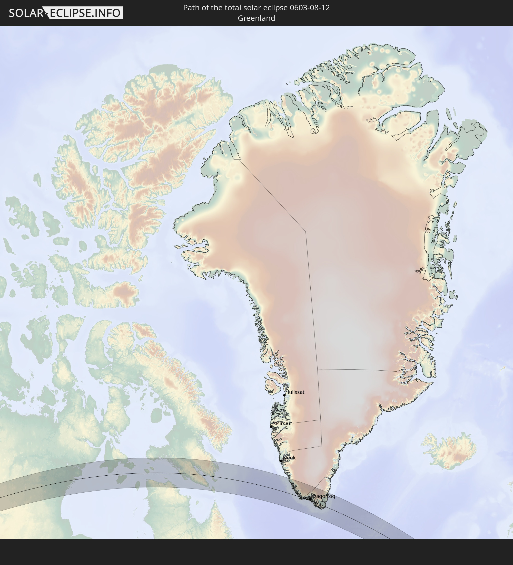 Grönland
 Spanien
 Frankreich
 Andorra
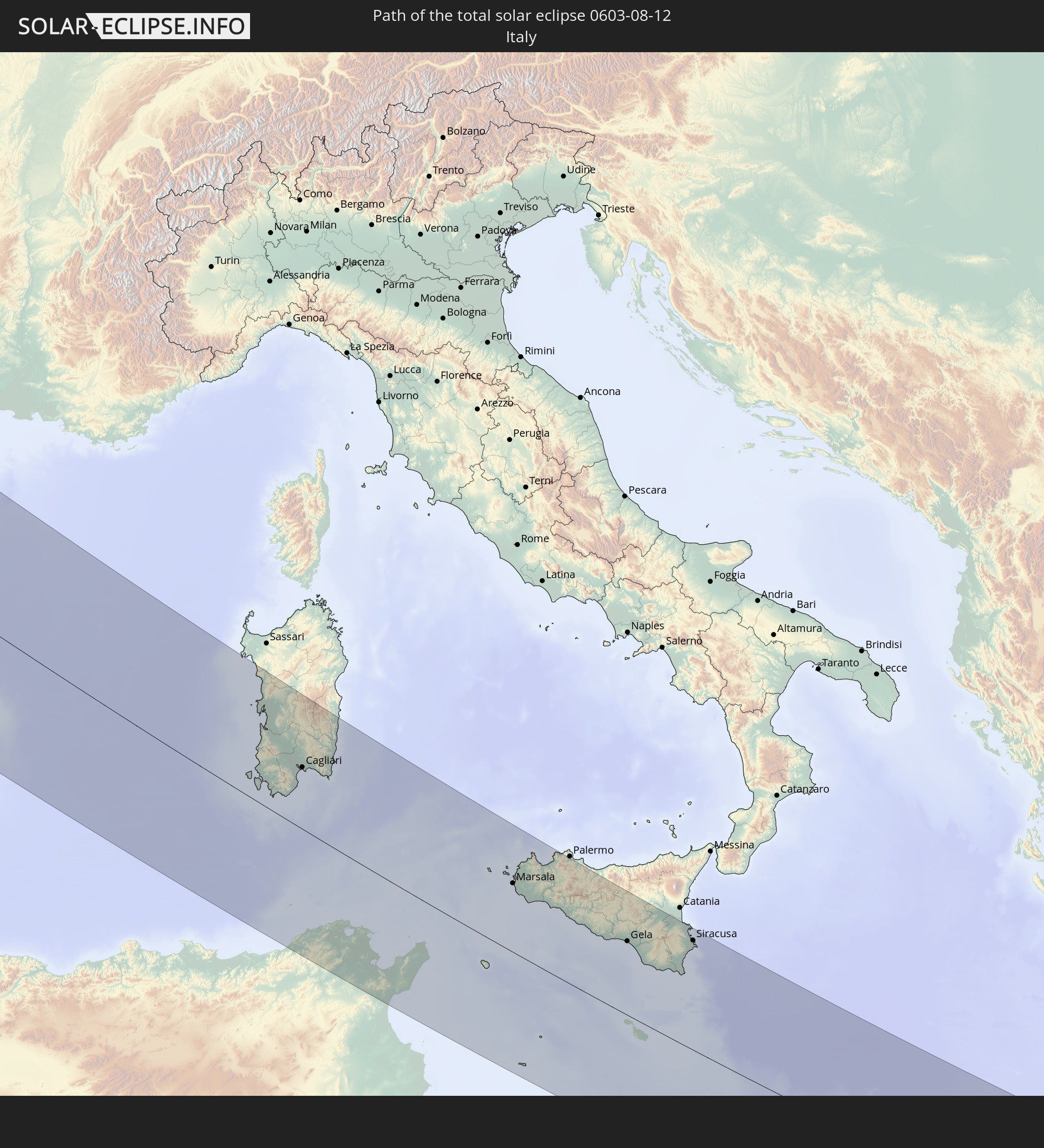 Italien
 Tunesien
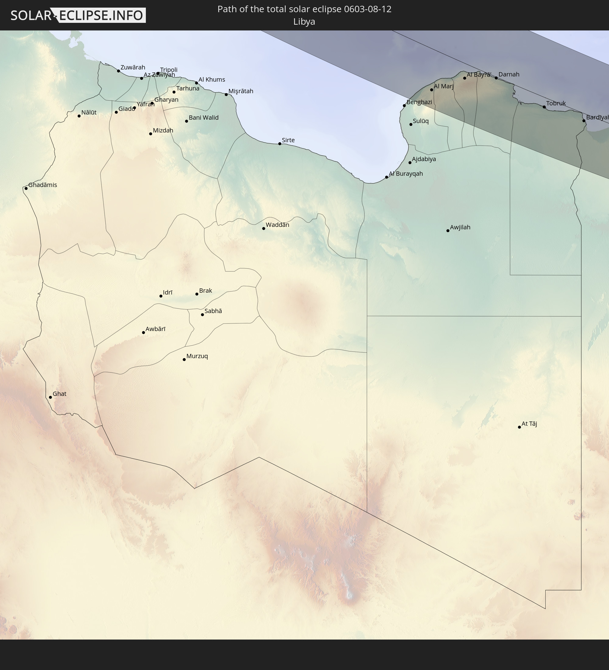 Libyen
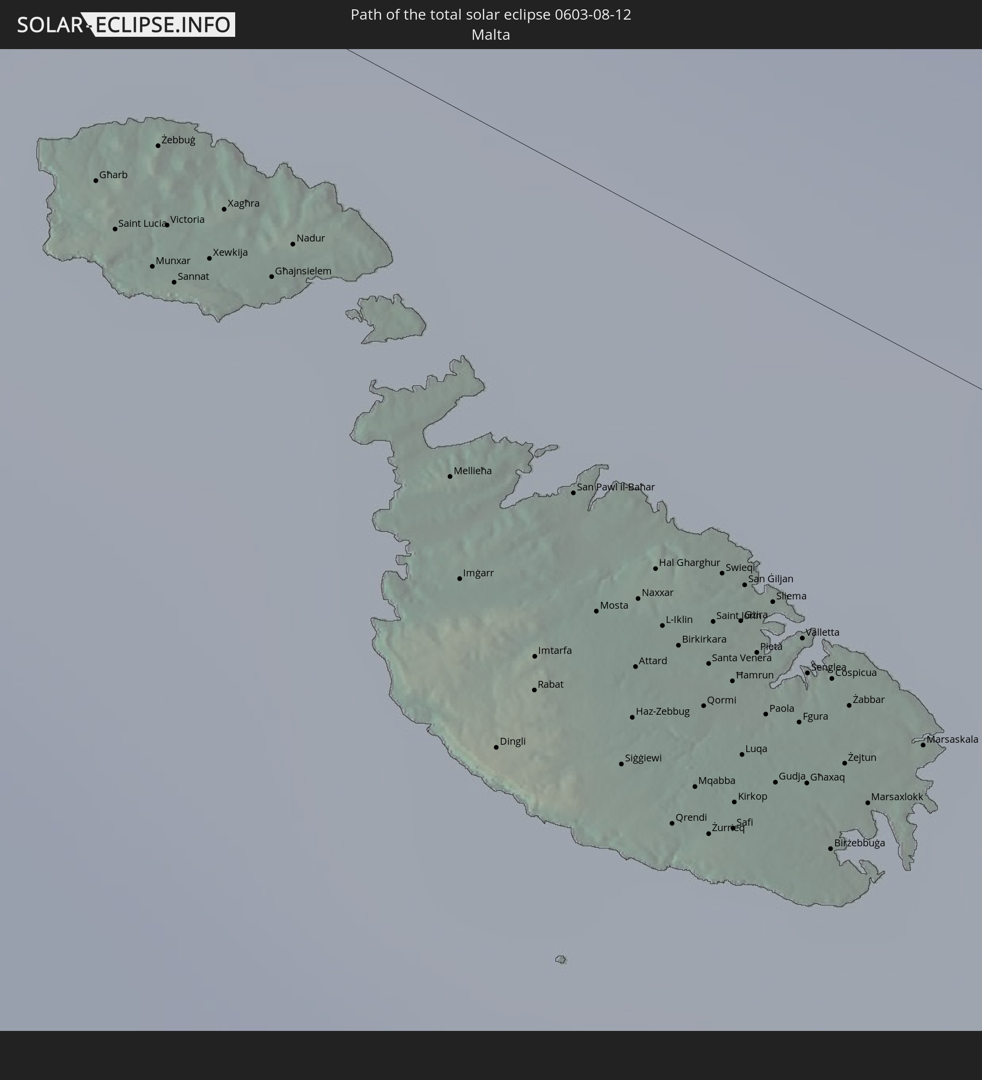 Malta
Malta
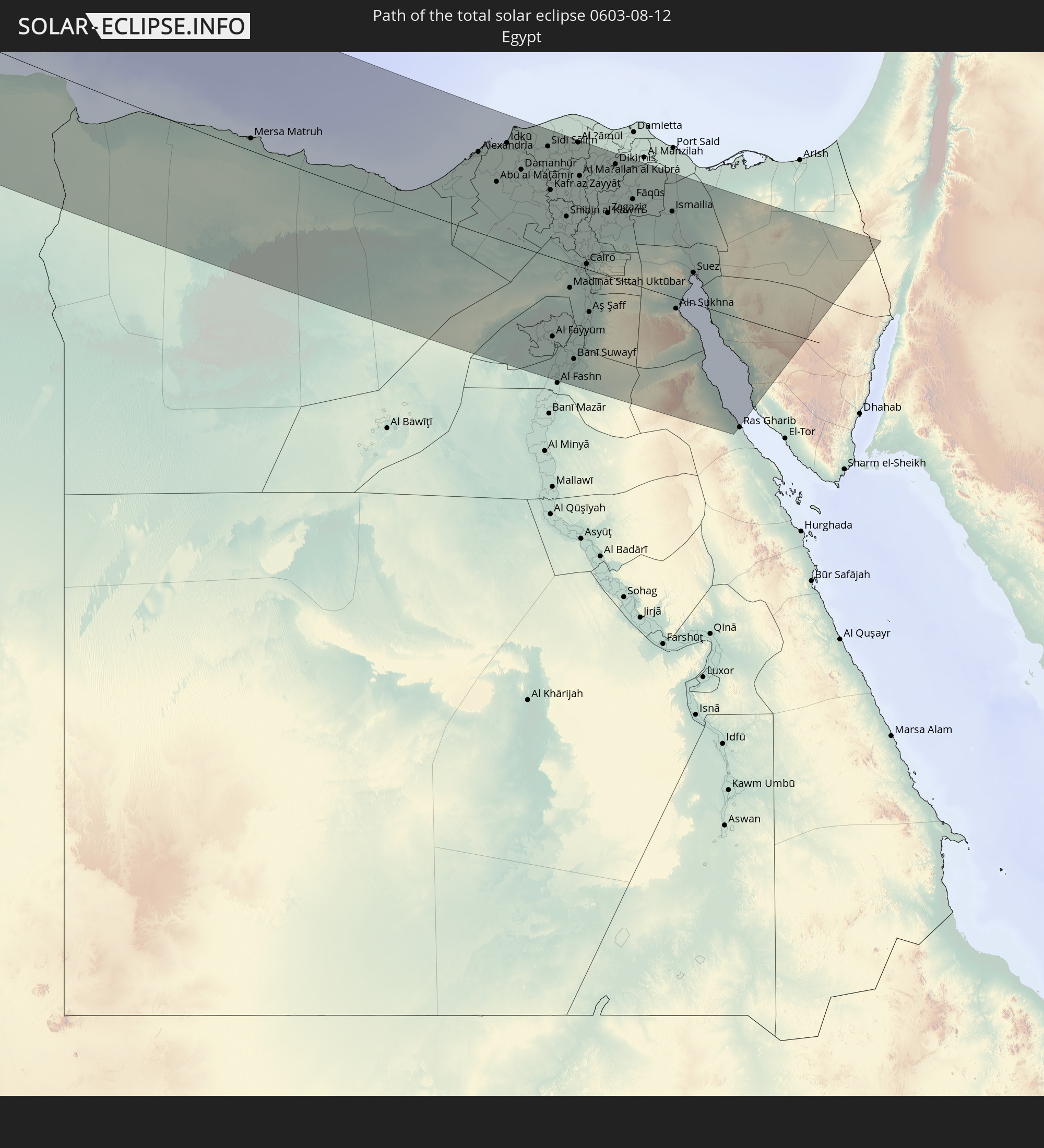 Ägypten
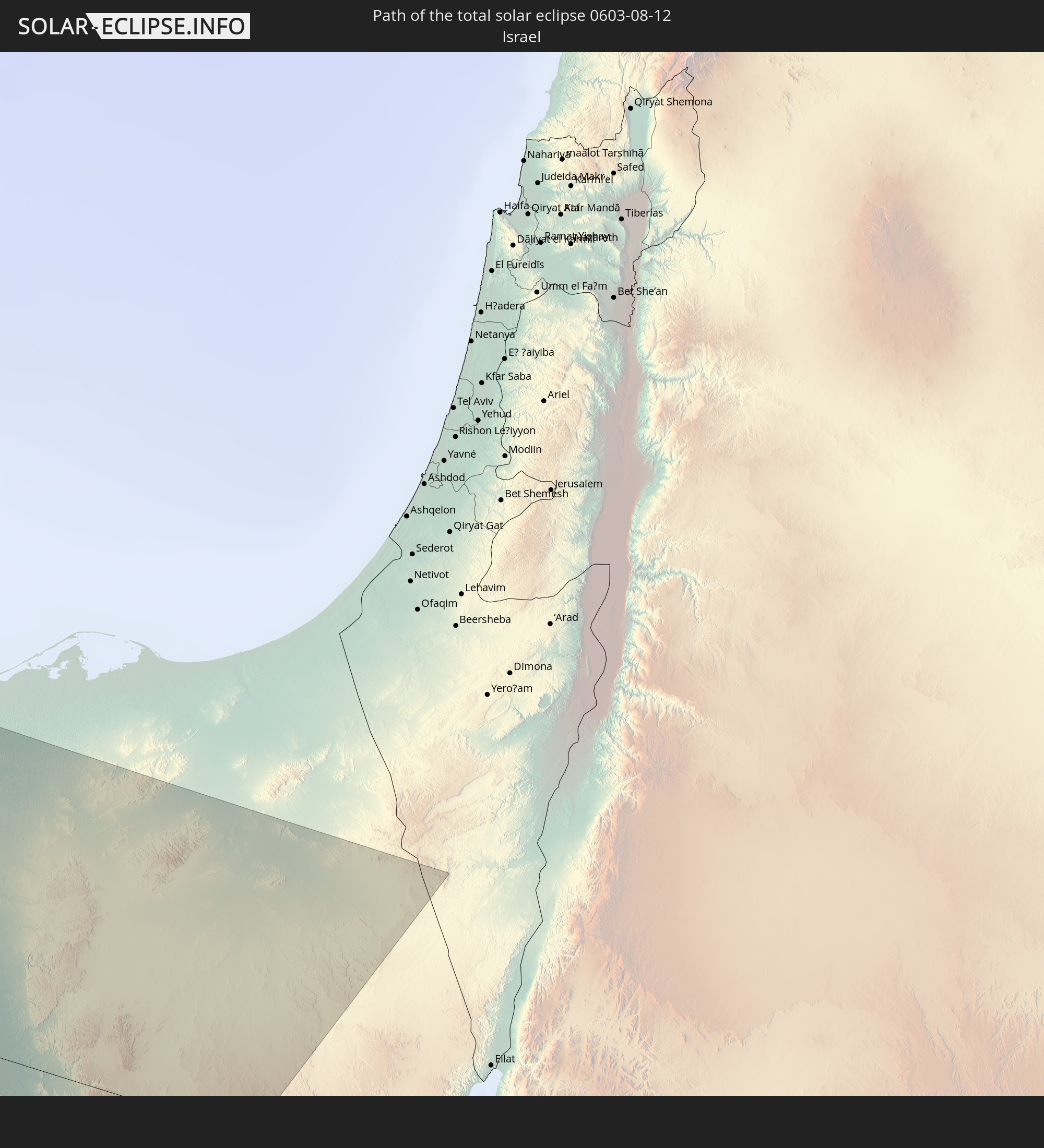 Israel
In den folgenden Ländern ist die Sonnenfinsternis partiell zu sehen
 Russland
 Vereinigte Staaten
 Kanada
 Mexiko
 Grönland
 Bermuda
 Saint-Pierre und Miquelon
 Portugal
 Kap Verde
 Island
 Spanien
 Senegal
 Mauretanien
 Gambia
 Guinea-Bissau
 Guinea
 Sierra Leone
 Marokko
 Mali
Mali
 Liberia
 Irland
 Spitzbergen
 Algerien
 Vereinigtes Königreich
 Elfenbeinküste
 Färöer
 Burkina Faso
 Gibraltar
 Frankreich
 Isle of Man
 Ghana
Ghana
 Guernsey
 Jersey
 Togo
Togo
 Niger
Niger
 Benin
Benin
 Andorra
 Belgien
 Nigeria
 Niederlande
 Norwegen
 Äquatorialguinea
 Luxemburg
 Deutschland
 Schweiz
 São Tomé und Príncipe
 Italien
 Monaco
 Tunesien
 Dänemark
 Kamerun
 Gabun
Gabun
 Libyen
 Liechtenstein
 Österreich
 Schweden
 Republik Kongo
 Tschechien
 Demokratische Republik Kongo
 San Marino
 Vatikanstadt
 Slowenien
 Tschad
 Kroatien
 Polen
Polen
 Malta
Malta
 Zentralafrikanische Republik
 Bosnien und Herzegowina
 Ungarn
 Slowakei
 Montenegro
 Serbien
 Albanien
 Åland Islands
 Griechenland
 Rumänien
 Mazedonien
 Finnland
 Litauen
 Lettland
 Estland
 Sudan
Sudan
 Ukraine
 Bulgarien
 Weißrussland
 Ägypten
 Türkei
 Moldawien
 Republik Zypern
 Staat Palästina
 Israel
 Jordanien
 Libanon
 Syrien
 Georgien
 Kasachstan
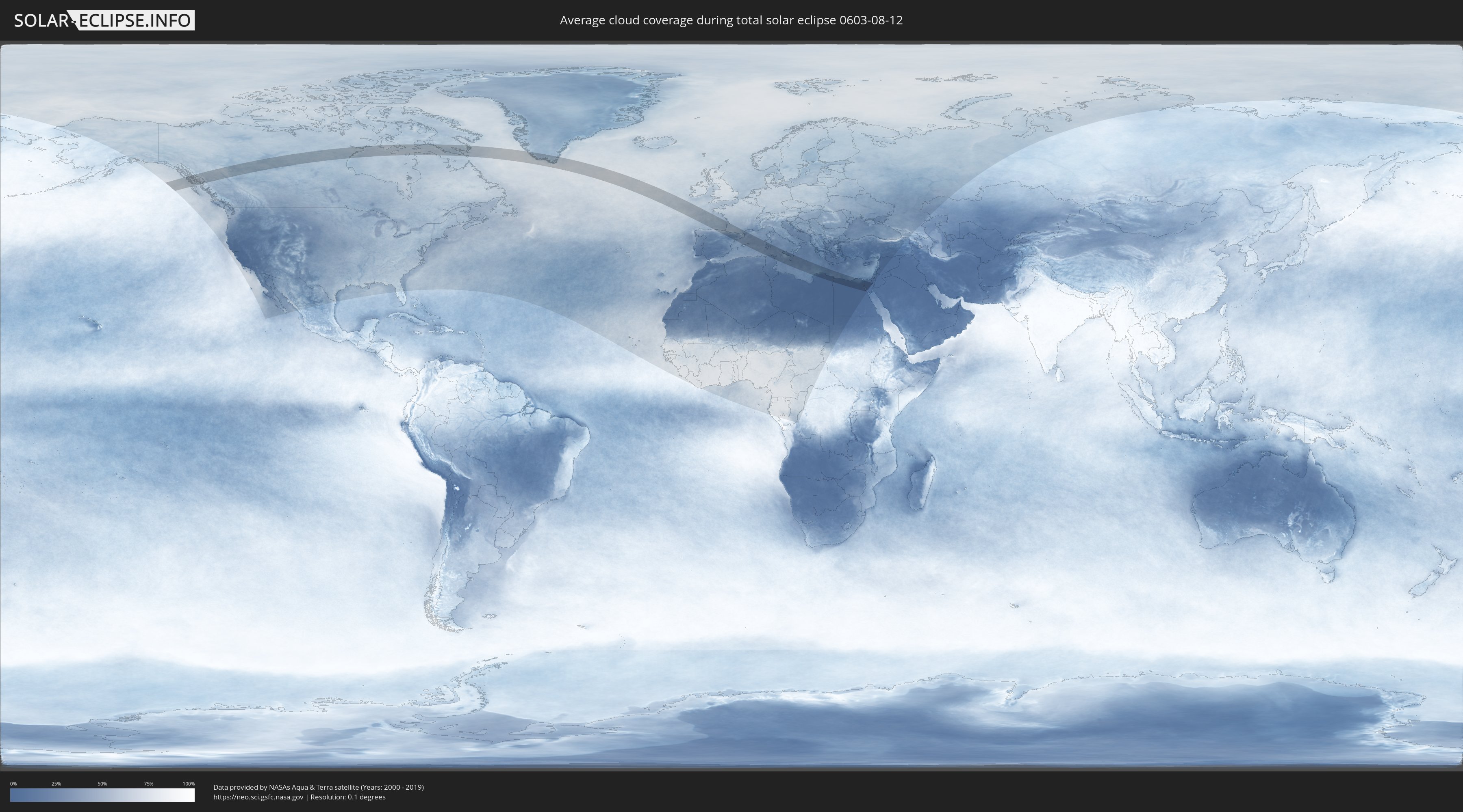
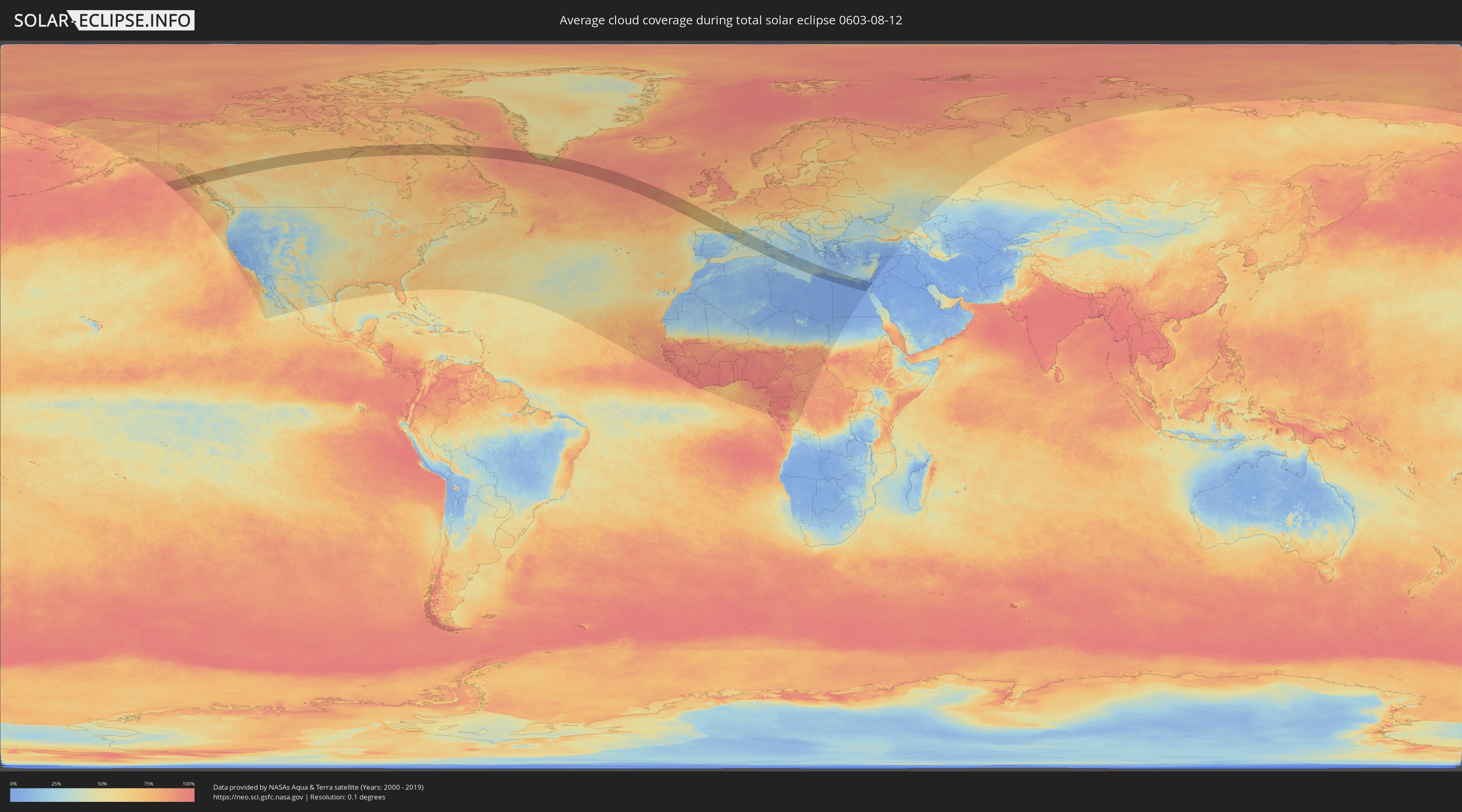
Wie wird das Wetter während der totalen Sonnenfinsternis am 12.08.0603?
Wo ist der beste Ort, um die totale Sonnenfinsternis vom 12.08.0603 zu beobachten?
Die folgenden Karten zeigen die durchschnittliche Bewölkung für den Tag, an dem die totale Sonnenfinsternis
stattfindet. Mit Hilfe der Karten lässt sich der Ort entlang des Finsternispfades eingrenzen,
der die besten Aussichen auf einen klaren wolkenfreien Himmel bietet.
Trotzdem muss man immer lokale Gegenenheiten beachten und sollte sich genau über das Wetter an seinem
gewählten Beobachtungsort informieren.
Die Daten stammen von den beiden NASA-Satelliten
AQUA und TERRA
und wurden über einen Zeitraum von 19 Jahren (2000 - 2019) gemittelt.
Detaillierte Länderkarten
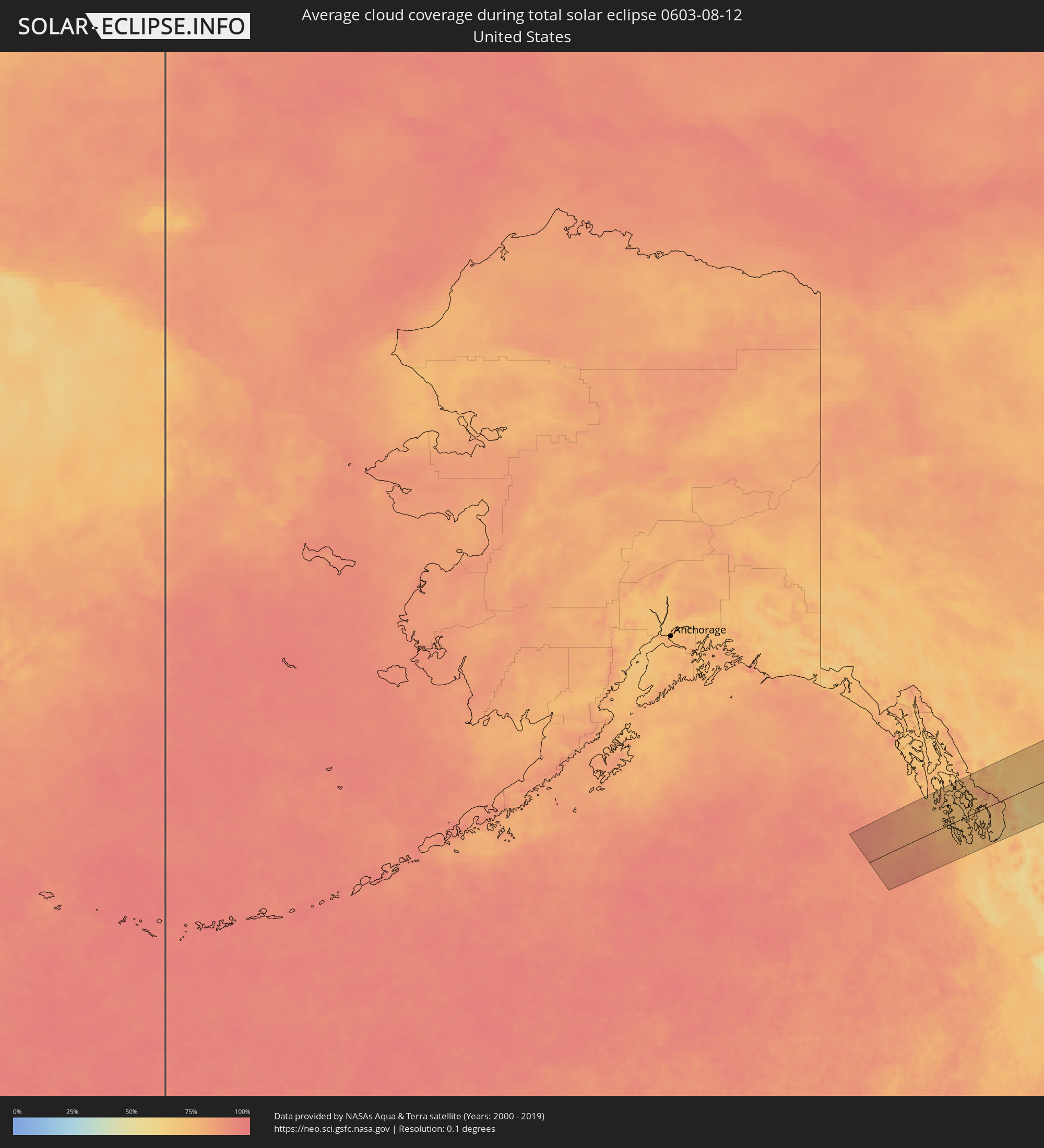 Vereinigte Staaten
 Kanada
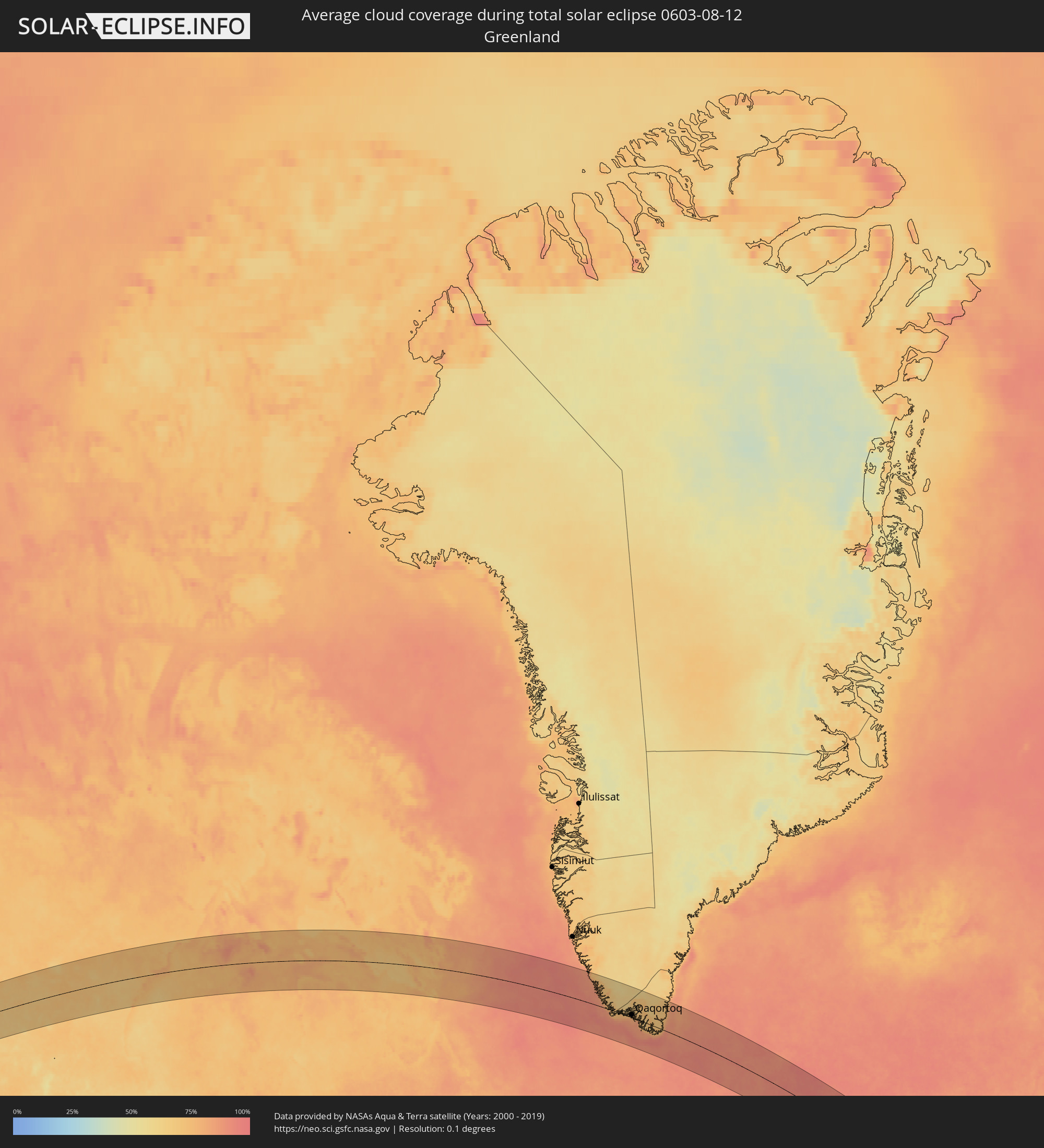 Grönland
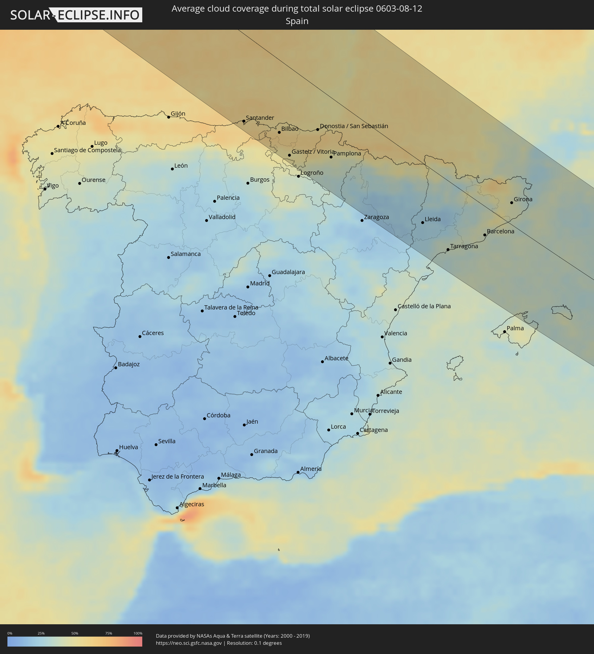 Spanien
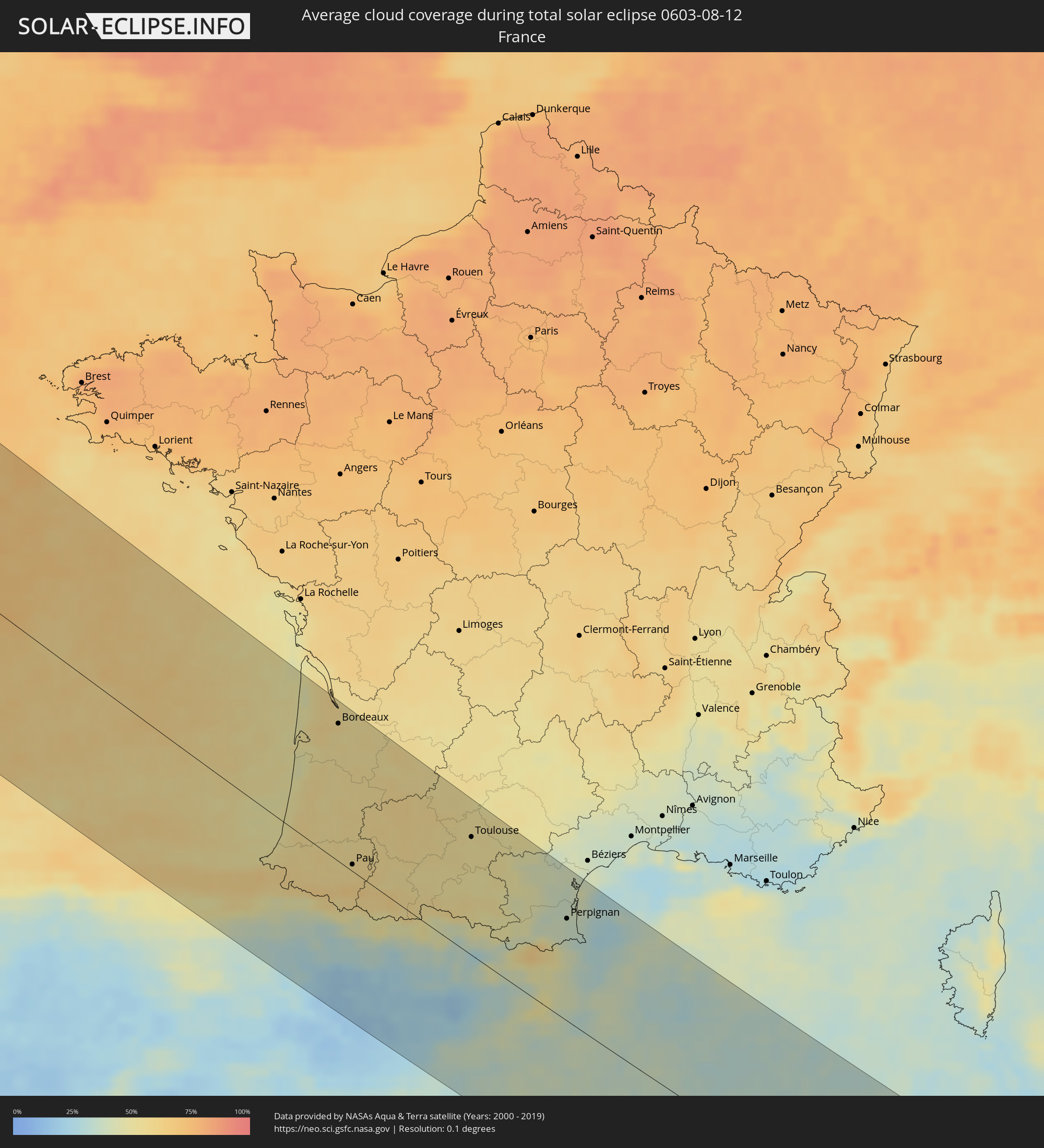 Frankreich
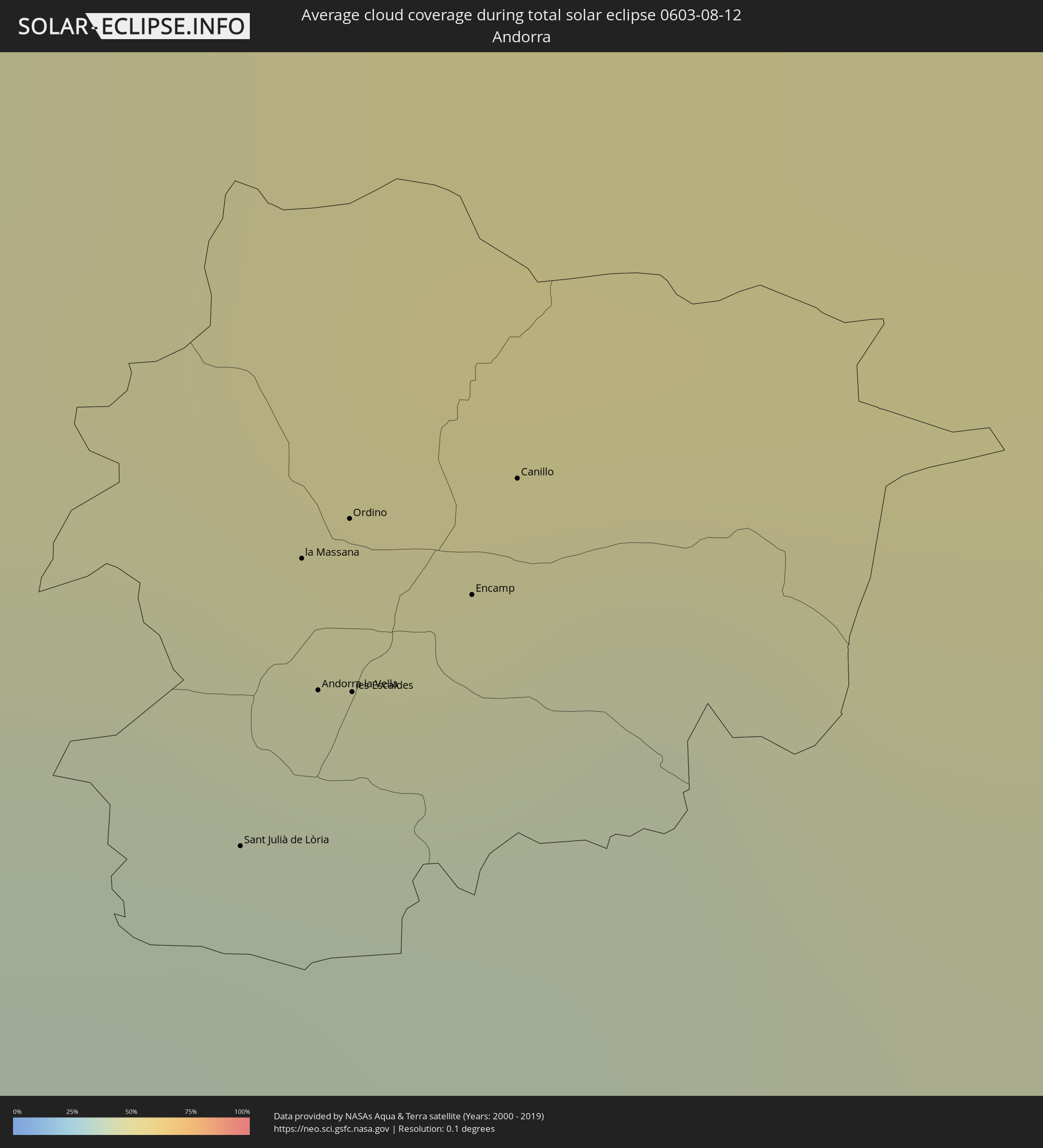 Andorra
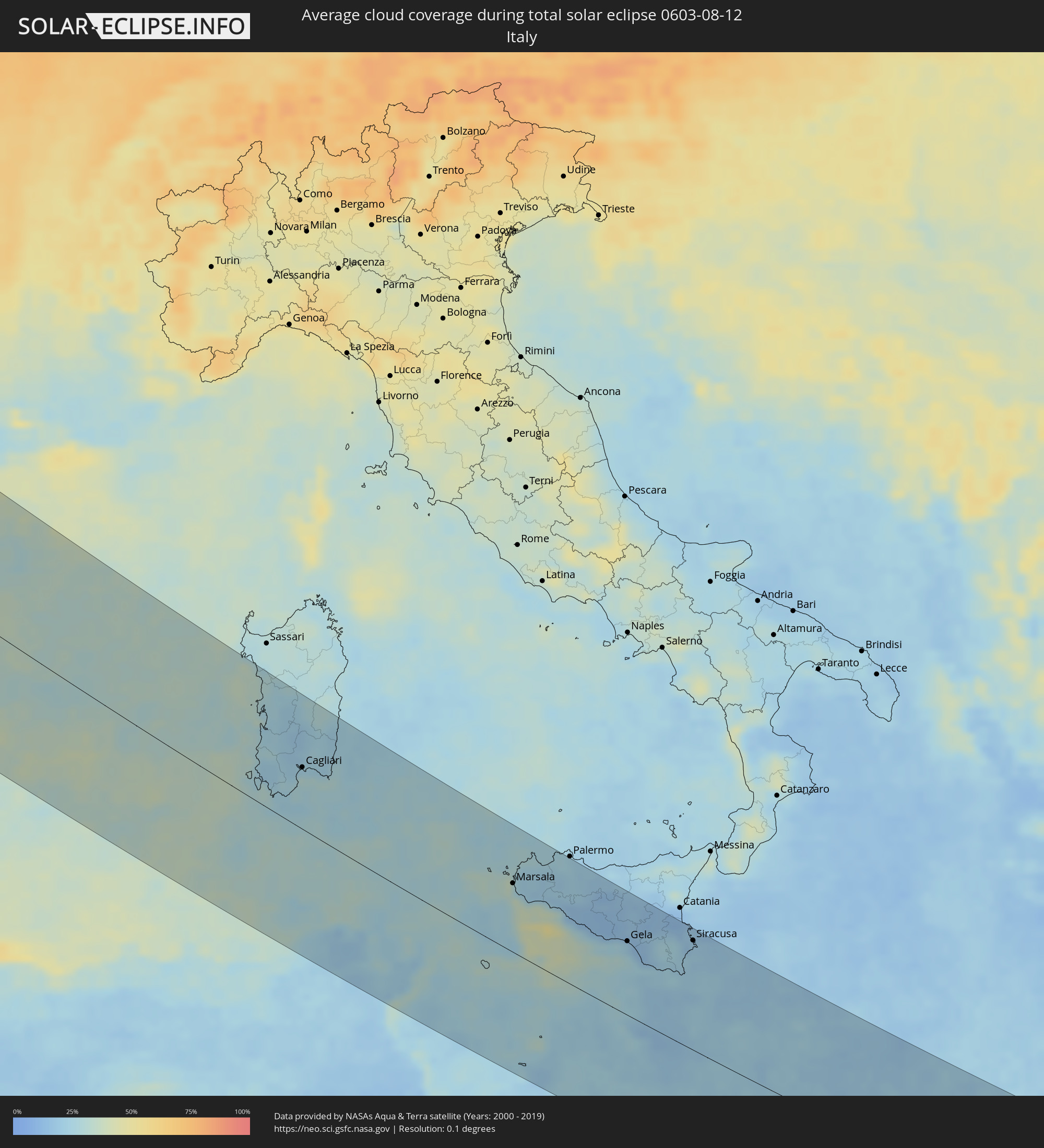 Italien
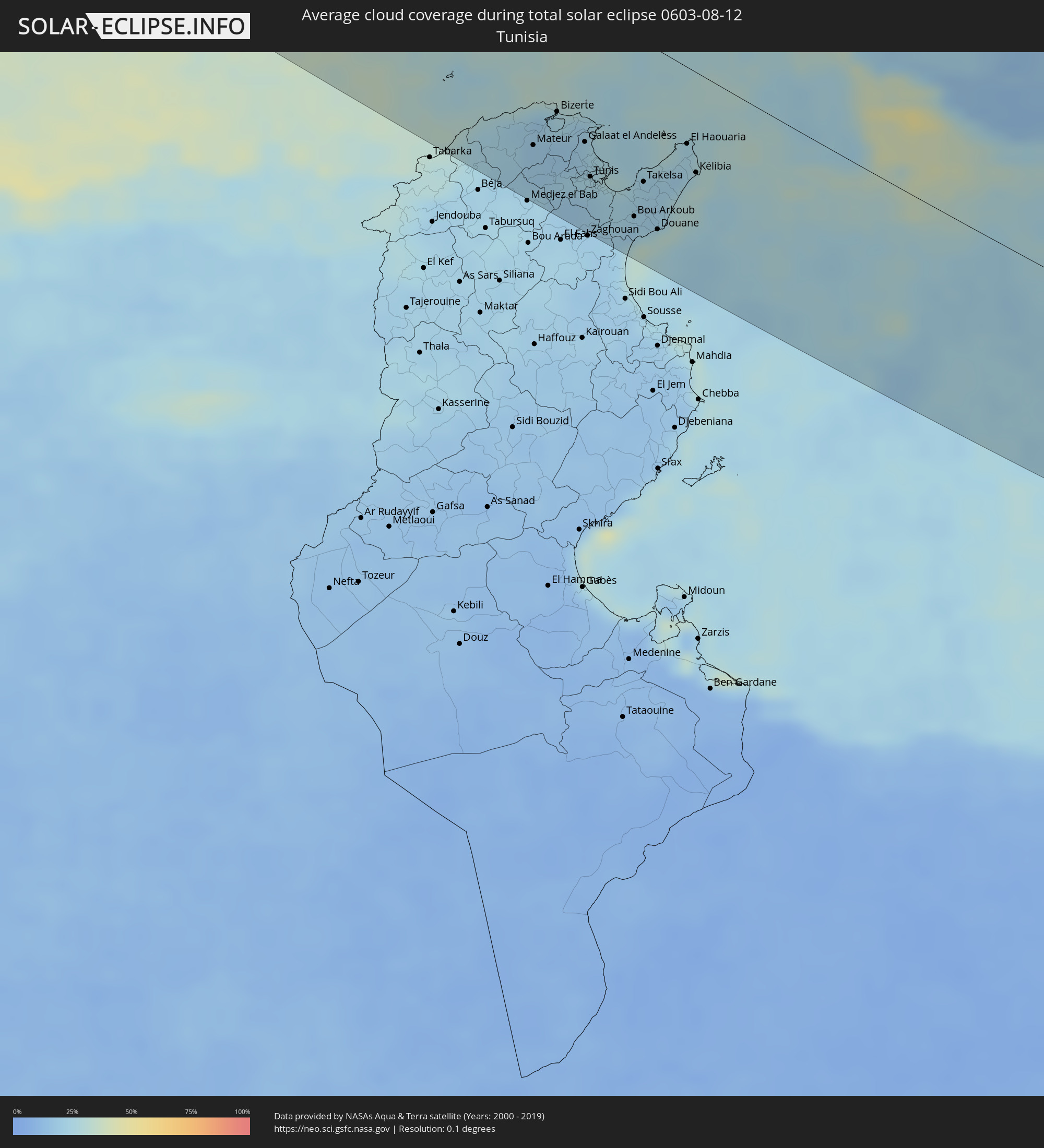 Tunesien
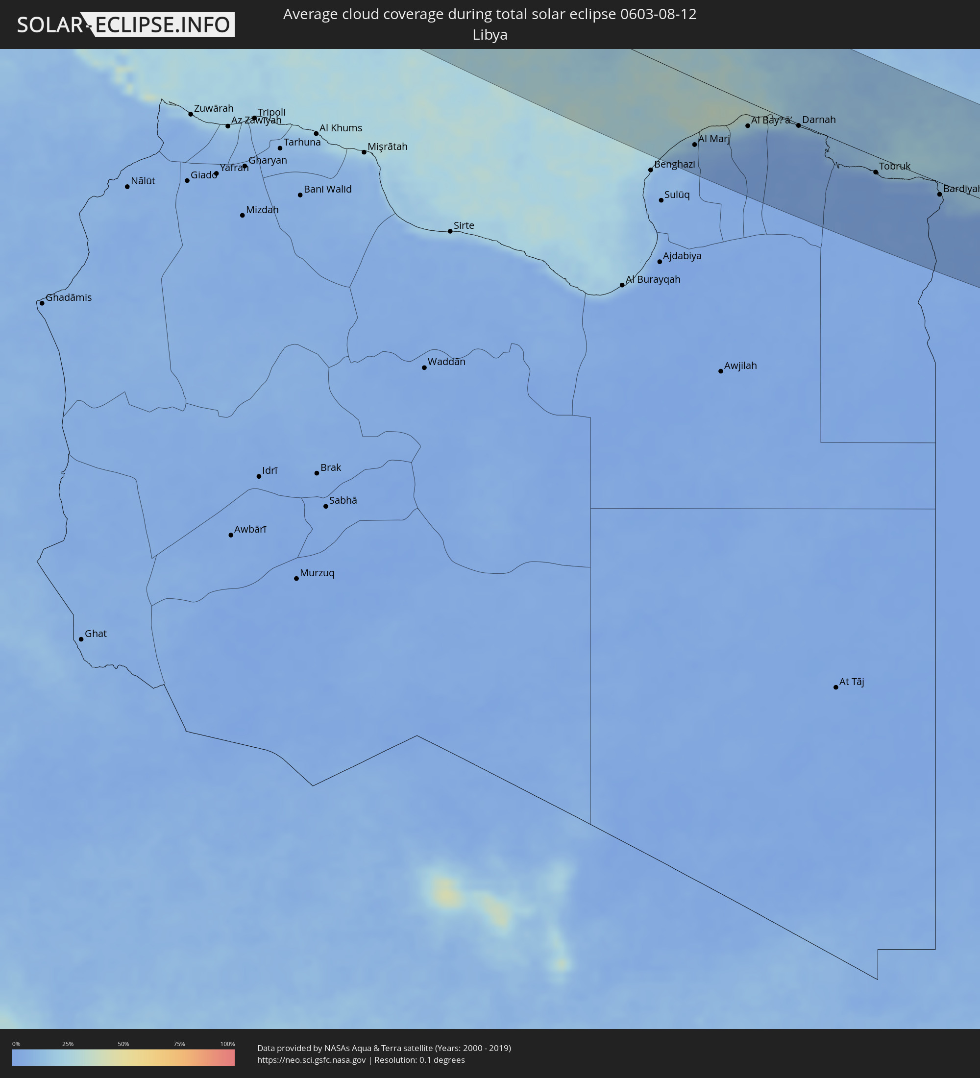 Libyen
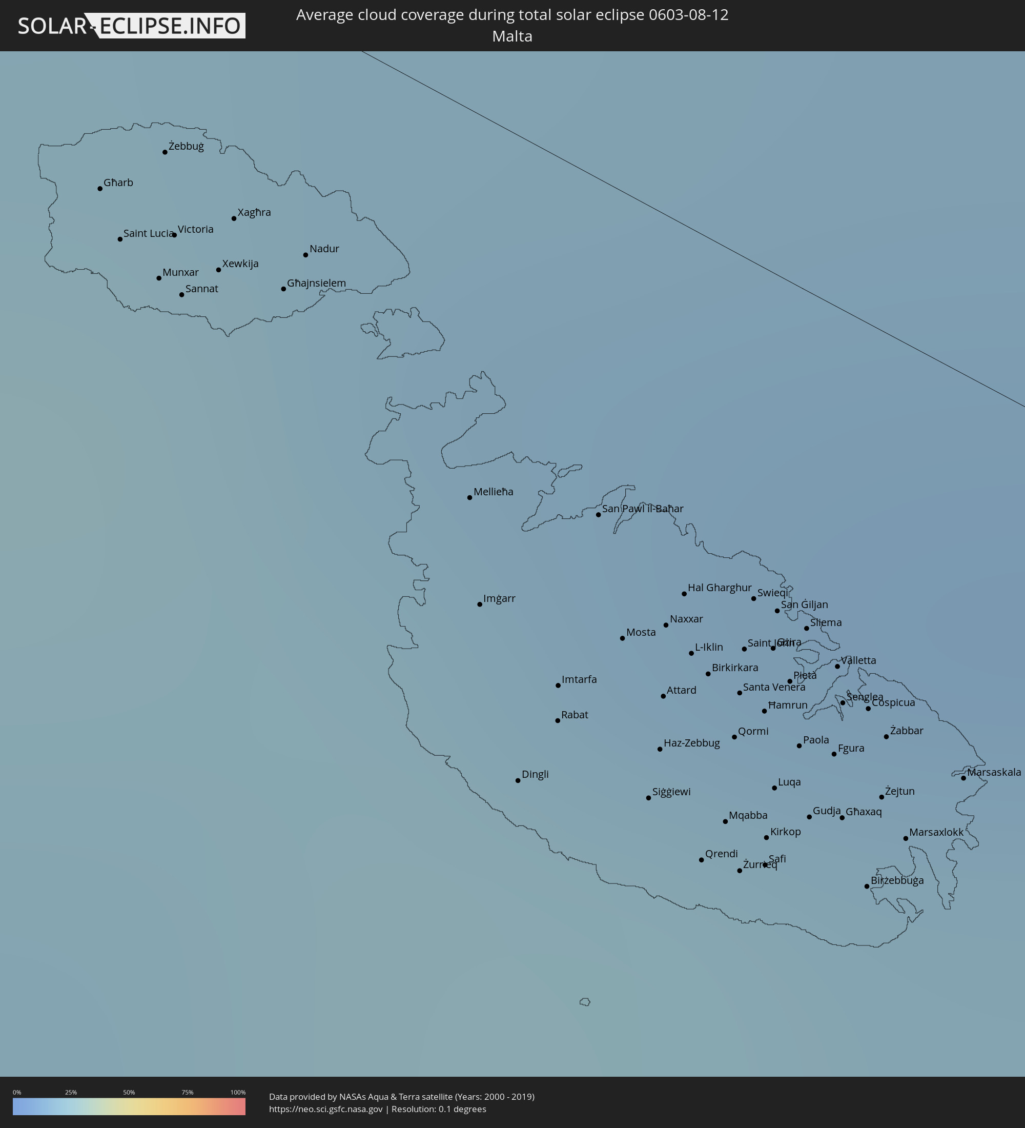 Malta
Malta
 Ägypten
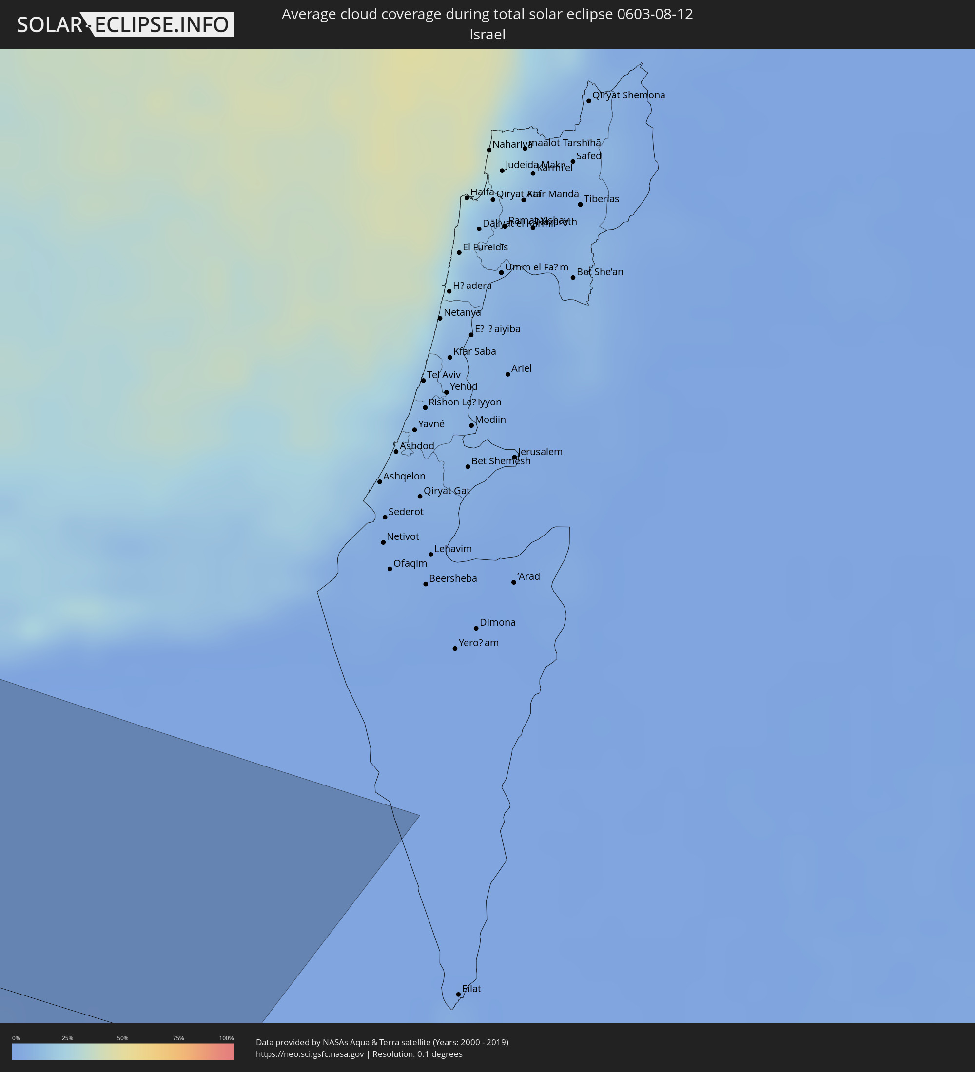 Israel
Orte im Finsternispfad
Die nachfolgene Tabelle zeigt Städte und Orte mit mehr als 5.000 Einwohnern, die sich im Finsternispfad befinden. Städte mit mehr als 100.000 Einwohnern sind dick gekennzeichnet. Mit einem Klick auf den Ort öffnet sich eine Detailkarte die die Lage des jeweiligen Ortes zusammen mit dem Verlauf der zentralen Finsternis präsentiert.
| Ort | Typ | Dauer der Verfinsterung | Ortszeit bei maximaler Verfinsterung | Entfernung zur Zentrallinie | Ø Bewölkung |
|
Ketchikan, Alaska
|
total | - | 03:50:56 UTC-10:00 | 44 km | 74% |
|
Iqaluit, Nunavut
|
total | - | 09:23:00 UTC-05:00 | 81 km | 77% |
|
Qaqortoq, Kujalleq
|
total | - | 11:16:50 UTC-03:26 | 15 km | 74% |
|
Santander, Cantabria
|
total | - | 15:51:03 UTC+00:00 | 141 km | 57% |
|
Bilbao, Basque Country
|
total | - | 15:52:04 UTC+00:00 | 117 km | 61% |
|
Gasteiz / Vitoria, Basque Country
|
total | - | 15:52:57 UTC+00:00 | 142 km | 47% |
|
Donostia / San Sebastián, Basque Country
|
total | - | 15:52:40 UTC+00:00 | 68 km | 61% |
|
Irun, Basque Country
|
total | - | 15:52:45 UTC+00:00 | 57 km | 63% |
|
Pamplona, Navarre
|
total | - | 15:53:45 UTC+00:00 | 97 km | 42% |
|
Bayonne, Nouvelle-Aquitaine
|
total | - | 16:02:04 UTC+00:09 | 29 km | 54% |
|
La Teste-de-Buch, Nouvelle-Aquitaine
|
total | - | 16:00:19 UTC+00:09 | 92 km | 48% |
|
Dax, Nouvelle-Aquitaine
|
total | - | 16:01:58 UTC+00:09 | 12 km | 56% |
|
Bordeaux, Nouvelle-Aquitaine
|
total | - | 16:00:20 UTC+00:09 | 135 km | 54% |
|
Mont-de-Marsan, Nouvelle-Aquitaine
|
total | - | 16:02:02 UTC+00:09 | 54 km | 56% |
|
Huesca, Aragon
|
total | - | 15:55:45 UTC+00:00 | 103 km | 20% |
|
Pau, Nouvelle-Aquitaine
|
total | - | 16:03:08 UTC+00:09 | 11 km | 56% |
|
Tarbes, Occitania
|
total | - | 16:03:33 UTC+00:09 | 23 km | 54% |
|
Marmande, Nouvelle-Aquitaine
|
total | - | 16:01:25 UTC+00:09 | 140 km | 52% |
|
Auch, Occitania
|
total | - | 16:03:09 UTC+00:09 | 83 km | 56% |
|
Lleida, Catalonia
|
total | - | 15:57:19 UTC+00:00 | 102 km | 23% |
|
Agen, Nouvelle-Aquitaine
|
total | - | 16:02:14 UTC+00:09 | 136 km | 56% |
|
Villeneuve-sur-Lot, Nouvelle-Aquitaine
|
total | - | 16:01:55 UTC+00:09 | 157 km | 55% |
|
Tarragona, Catalonia
|
total | - | 15:58:33 UTC+00:00 | 117 km | 33% |
|
Muret, Occitania
|
total | - | 16:03:56 UTC+00:09 | 103 km | 52% |
|
Montauban, Occitania
|
total | - | 16:02:59 UTC+00:09 | 154 km | 53% |
|
Toulouse, Occitania
|
total | - | 16:03:46 UTC+00:09 | 120 km | 51% |
|
Sant Julià de Lòria, Sant Julià de Loria
|
total | - | 15:56:24 UTC+00:00 | 23 km | 39% |
|
la Massana, La Massana
|
total | - | 15:56:16 UTC+00:00 | 32 km | 39% |
|
Andorra la Vella, Andorra la Vella
|
total | - | 15:56:20 UTC+00:00 | 28 km | 39% |
|
Ordino, Ordino
|
total | - | 15:56:16 UTC+00:00 | 33 km | 45% |
|
les Escaldes, Escaldes-Engordany
|
total | - | 15:56:21 UTC+00:00 | 28 km | 39% |
|
Encamp, Encamp
|
total | - | 15:56:20 UTC+00:00 | 31 km | 40% |
|
Canillo, Canillo
|
total | - | 15:56:17 UTC+00:00 | 35 km | 43% |
|
Pamiers, Occitania
|
total | - | 16:04:42 UTC+00:09 | 83 km | 50% |
|
Vilanova i la Geltrú, Catalonia
|
total | - | 15:58:40 UTC+00:00 | 87 km | 34% |
|
Manresa, Catalonia
|
total | - | 15:57:51 UTC+00:00 | 34 km | 34% |
|
Castelldefels, Catalonia
|
total | - | 15:58:43 UTC+00:00 | 68 km | 38% |
|
Terrassa, Catalonia
|
total | - | 15:58:15 UTC+00:00 | 45 km | 42% |
|
Barcelona, Catalonia
|
total | - | 15:58:38 UTC+00:00 | 49 km | 38% |
|
Mollet del Vallès, Catalonia
|
total | - | 15:58:24 UTC+00:00 | 33 km | 36% |
|
Castres, Occitania
|
total | - | 16:04:15 UTC+00:09 | 157 km | 50% |
|
Carcassonne, Occitania
|
total | - | 16:04:58 UTC+00:09 | 127 km | 45% |
|
Mataró, Catalonia
|
total | - | 15:58:32 UTC+00:00 | 23 km | 36% |
|
Blanes, Catalonia
|
total | - | 15:58:31 UTC+00:00 | 25 km | 40% |
|
Girona, Catalonia
|
total | - | 15:58:00 UTC+00:00 | 38 km | 43% |
|
Perpignan, Occitania
|
total | - | 16:06:10 UTC+00:09 | 107 km | 37% |
|
Figueres, Catalonia
|
total | - | 15:57:36 UTC+00:00 | 69 km | 38% |
|
Narbonne, Occitania
|
total | - | 16:05:24 UTC+00:09 | 155 km | 40% |
|
Cagliari, Sardinia
|
total | - | 17:05:35 UTC+01:00 | 74 km | 31% |
|
Mateur, Banzart
|
total | - | 16:18:40 UTC+00:09 | 114 km | 19% |
|
Douar Tindja, Banzart
|
total | - | 16:18:30 UTC+00:09 | 99 km | 22% |
|
Menzel Bourguiba, Banzart
|
total | - | 16:18:32 UTC+00:09 | 98 km | 22% |
|
Menzel Abderhaman, Banzart
|
total | - | 16:18:25 UTC+00:09 | 86 km | 22% |
|
Bizerte, Banzart
|
total | - | 16:18:22 UTC+00:09 | 82 km | 25% |
|
El Alia, Banzart
|
total | - | 16:18:35 UTC+00:09 | 84 km | 21% |
|
Galaat el Andeless, Ariana
|
total | - | 16:18:47 UTC+00:09 | 91 km | 21% |
|
La Mohammedia, Tūnis
|
total | - | 16:19:25 UTC+00:09 | 127 km | 21% |
|
Tunis, Tūnis
|
total | - | 16:19:12 UTC+00:09 | 113 km | 23% |
|
Al Marsá, Tūnis
|
total | - | 16:19:09 UTC+00:09 | 99 km | 29% |
|
Carthage, Tūnis
|
total | - | 16:19:11 UTC+00:09 | 101 km | 29% |
|
Hammam-Lif, Tūnis
|
total | - | 16:19:24 UTC+00:09 | 112 km | 23% |
|
Mennzel Bou Zelfa, Nābul
|
total | - | 16:19:33 UTC+00:09 | 108 km | 21% |
|
Beni Khalled, Nābul
|
total | - | 16:19:36 UTC+00:09 | 111 km | 21% |
|
Takelsa, Nābul
|
total | - | 16:19:24 UTC+00:09 | 96 km | 22% |
|
Douane, Nābul
|
total | - | 16:19:58 UTC+00:09 | 121 km | 29% |
|
Beni Khiar, Nābul
|
total | - | 16:19:57 UTC+00:09 | 118 km | 31% |
|
Korba, Nābul
|
total | - | 16:19:48 UTC+00:09 | 104 km | 31% |
|
Kélibia, Nābul
|
total | - | 16:19:26 UTC+00:09 | 68 km | 31% |
|
Marsala, Sicily
|
total | - | 17:08:58 UTC+01:00 | 83 km | 34% |
|
Trapani, Sicily
|
total | - | 17:08:39 UTC+01:00 | 109 km | 26% |
|
Mazara del Vallo, Sicily
|
total | - | 17:09:14 UTC+01:00 | 78 km | 30% |
|
Castelvetrano, Sicily
|
total | - | 17:09:15 UTC+01:00 | 90 km | 23% |
|
Alcamo, Sicily
|
total | - | 17:08:49 UTC+01:00 | 126 km | 21% |
|
Sciacca, Sicily
|
total | - | 17:09:36 UTC+01:00 | 84 km | 35% |
|
Carini, Sicily
|
total | - | 17:08:38 UTC+01:00 | 149 km | 24% |
|
Agrigento, Sicily
|
total | - | 17:10:02 UTC+01:00 | 86 km | 21% |
|
Canicattì, Sicily
|
total | - | 17:10:01 UTC+01:00 | 104 km | 14% |
|
Licata, Sicily
|
total | - | 17:10:26 UTC+01:00 | 81 km | 26% |
|
Caltanissetta, Sicily
|
total | - | 17:09:51 UTC+01:00 | 125 km | 14% |
|
San Lawrenz, Saint Lawrence
|
total | - | 17:12:07 UTC+01:00 | 10 km | 26% |
|
Għarb, L-Għarb
|
total | - | 17:12:07 UTC+01:00 | 9 km | 26% |
|
Kerċem, Ta’ Kerċem
|
total | - | 17:12:09 UTC+01:00 | 10 km | 25% |
|
Munxar, Il-Munxar
|
total | - | 17:12:10 UTC+01:00 | 11 km | 25% |
|
Żebbuġ, Iż-Żebbuġ
|
total | - | 17:12:06 UTC+01:00 | 7 km | 26% |
|
Fontana, Il-Fontana
|
total | - | 17:12:09 UTC+01:00 | 10 km | 25% |
|
Victoria, Victoria
|
total | - | 17:12:09 UTC+01:00 | 9 km | 25% |
|
Gela, Sicily
|
total | - | 17:10:33 UTC+01:00 | 95 km | 23% |
|
Sannat, Sannat
|
total | - | 17:12:11 UTC+01:00 | 11 km | 25% |
|
Imtarfa, L-Imtarfa
|
total | - | 17:12:25 UTC+01:00 | 17 km | 25% |
|
Lija, Lija
|
total | - | 17:12:24 UTC+01:00 | 15 km | 25% |
|
Hal Gharghur, Ħal Għargħur
|
total | - | 17:12:22 UTC+01:00 | 12 km | 22% |
|
Qrendi, Il-Qrendi
|
total | - | 17:12:31 UTC+01:00 | 21 km | 22% |
|
Birkirkara, Birkirkara
|
total | - | 17:12:25 UTC+01:00 | 14 km | 22% |
|
Mqabba, L-Imqabba
|
total | - | 17:12:30 UTC+01:00 | 19 km | 22% |
|
Safi, Safi
|
total | - | 17:12:31 UTC+01:00 | 20 km | 22% |
|
Kirkop, Kirkop
|
total | - | 17:12:30 UTC+01:00 | 19 km | 22% |
|
Ta’ Xbiex, Ta’ Xbiex
|
total | - | 17:12:25 UTC+01:00 | 13 km | 22% |
|
Floriana, Il-Furjana
|
total | - | 17:12:26 UTC+01:00 | 13 km | 22% |
|
Caltagirone, Sicily
|
total | - | 17:10:21 UTC+01:00 | 120 km | 17% |
|
Vittoria, Sicily
|
total | - | 17:10:48 UTC+01:00 | 92 km | 13% |
|
Xgħajra, Ix-Xgħajra
|
total | - | 17:12:27 UTC+01:00 | 12 km | 22% |
|
Ragusa, Sicily
|
total | - | 17:10:53 UTC+01:00 | 100 km | 18% |
|
Avola, Sicily
|
total | - | 17:11:00 UTC+01:00 | 114 km | 23% |
|
Augusta, Sicily
|
total | - | 17:10:30 UTC+01:00 | 149 km | 19% |
|
Siracusa, Sicily
|
total | - | 17:10:45 UTC+01:00 | 137 km | 20% |
|
Tūkrah, Al Marj
|
total | - | 17:10:45 UTC+00:52 | 104 km | 12% |
|
Al Abyār, Al Marj
|
total | - | 17:11:14 UTC+00:52 | 138 km | 8% |
|
Al Marj, Al Marj
|
total | - | 17:10:49 UTC+00:52 | 99 km | 8% |
|
Al Bayḑā’, Al Jabal al Akhḑar
|
total | - | 17:10:26 UTC+00:52 | 37 km | 14% |
|
Al Qubbah, Darnah
|
total | - | 17:10:25 UTC+00:52 | 26 km | 8% |
|
Darnah, Darnah
|
total | - | 17:10:24 UTC+00:52 | 15 km | 13% |
|
Tobruk, Sha‘bīyat al Buţnān
|
total | - | 17:11:16 UTC+00:52 | 25 km | 8% |
|
Bardīyah, Sha‘bīyat al Buţnān
|
total | - | 17:11:37 UTC+00:52 | 25 km | 7% |
|
Alexandria, Alexandria
|
total | - | 18:18:50 UTC+02:00 | 88 km | 13% |
|
Kafr ad Dawwār, Beheira
|
total | - | 18:18:54 UTC+02:00 | 85 km | 14% |
|
Idkū, Beheira
|
total | - | 18:18:39 UTC+02:00 | 108 km | 12% |
|
Damanhūr, Beheira
|
total | - | 18:18:58 UTC+02:00 | 86 km | 15% |
|
Al Fayyūm, Faiyum
|
total | - | 18:21:00 UTC+02:00 | 87 km | 1% |
|
Kafr ash Shaykh, Kafr el-Sheikh
|
total | - | 18:18:45 UTC+02:00 | 107 km | 18% |
|
Tanda, Gharbia
|
total | - | 18:19:09 UTC+02:00 | 79 km | 13% |
|
Shibīn al Kawm, Monufia
|
total | - | 18:19:26 UTC+02:00 | 52 km | 10% |
|
Banī Suwayf, Beni Suweif
|
total | - | 18:21:13 UTC+02:00 | 104 km | 0% |
|
Al Maḩallah al Kubrá, Gharbia
|
total | - | 18:18:53 UTC+02:00 | 100 km | 17% |
|
Banhā, Qalyubia
|
total | - | 18:19:31 UTC+02:00 | 45 km | 8% |
|
Cairo, Cairo
|
total | - | 18:19:59 UTC+02:00 | 24 km | 0% |
|
Ḩalwān, Cairo
|
total | - | 18:20:14 UTC+02:00 | 22 km | 0% |
|
Al Manşūrah, Dakahlia
|
total | - | 18:18:45 UTC+02:00 | 112 km | 17% |
|
Zagazig, Sharqia
|
total | - | 18:19:16 UTC+02:00 | 72 km | 11% |
|
Bilbays, Sharqia
|
total | - | 18:19:28 UTC+02:00 | 54 km | 3% |
|
Dikirnis, Dakahlia
|
total | - | 18:18:38 UTC+02:00 | 126 km | 21% |
|
Ismailia, Ismailia
|
total | - | 18:19:03 UTC+02:00 | 94 km | 2% |
|
Suez, Suez
|
total | - | 18:19:45 UTC+02:00 | 35 km | 2% |