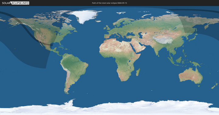
Totale Sonnenfinsternis vom 15.09.0684
| Wochentag: | Montag |
| Maximale Dauer der Verfinsterung: | 03m11s |
| Maximale Breite des Finsternispfades: | 263 km |
| Saroszyklus: | 84 |
| Bedeckungsgrad: | 100% |
| Magnitude: | 1.0468 |
| Gamma: | 0.814 |
Wo kann man die Sonnenfinsternis vom 15.09.0684 sehen?
Die Sonnenfinsternis am 15.09.0684 kann man in 8 Ländern als partielle Sonnenfinsternis beobachten.
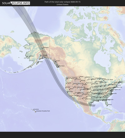
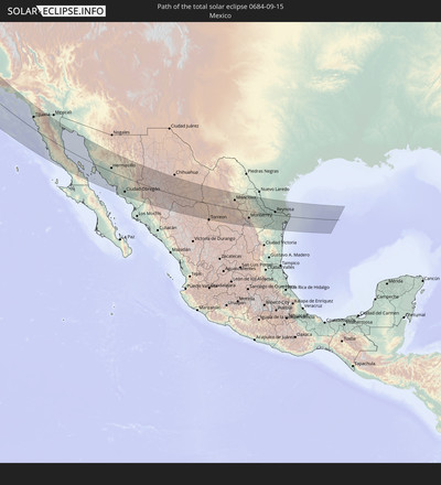
Der Finsternispfad verläuft durch 2 Länder. Nur in diesen Ländern ist sie als totale Sonnenfinsternis zu sehen.
In den folgenden Ländern ist die Sonnenfinsternis total zu sehen
In den folgenden Ländern ist die Sonnenfinsternis partiell zu sehen
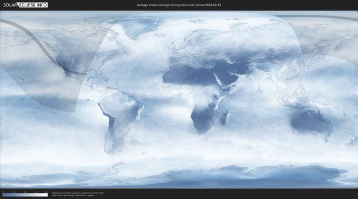
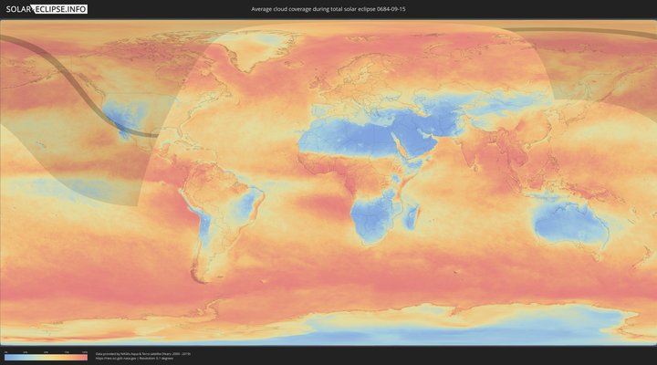
Wie wird das Wetter während der totalen Sonnenfinsternis am 15.09.0684?
Wo ist der beste Ort, um die totale Sonnenfinsternis vom 15.09.0684 zu beobachten?
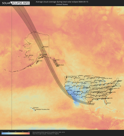
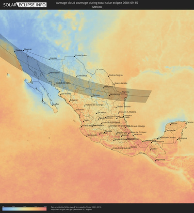
Die folgenden Karten zeigen die durchschnittliche Bewölkung für den Tag, an dem die totale Sonnenfinsternis
stattfindet. Mit Hilfe der Karten lässt sich der Ort entlang des Finsternispfades eingrenzen,
der die besten Aussichen auf einen klaren wolkenfreien Himmel bietet.
Trotzdem muss man immer lokale Gegenenheiten beachten und sollte sich genau über das Wetter an seinem
gewählten Beobachtungsort informieren.
Die Daten stammen von den beiden NASA-Satelliten
AQUA und TERRA
und wurden über einen Zeitraum von 19 Jahren (2000 - 2019) gemittelt.
Detaillierte Länderkarten
Orte im Finsternispfad
Die nachfolgene Tabelle zeigt Städte und Orte mit mehr als 5.000 Einwohnern, die sich im Finsternispfad befinden. Städte mit mehr als 100.000 Einwohnern sind dick gekennzeichnet. Mit einem Klick auf den Ort öffnet sich eine Detailkarte die die Lage des jeweiligen Ortes zusammen mit dem Verlauf der zentralen Finsternis präsentiert.
| Ort | Typ | Dauer der Verfinsterung | Ortszeit bei maximaler Verfinsterung | Entfernung zur Zentrallinie | Ø Bewölkung |
 College, Alaska
|
total | - | 12:34:09 UTC-10:00 | 46 km | 72% |
 Fairbanks, Alaska
|
total | - | 12:34:14 UTC-10:00 | 48 km | 68% |
 Badger, Alaska
|
total | - | 12:34:24 UTC-10:00 | 55 km | 67% |
 Santa Cruz, California
|
total | - | 15:40:14 UTC-08:00 | 142 km | 34% |
 Pacific Grove, California
|
total | - | 15:41:00 UTC-08:00 | 122 km | 42% |
 Seaside, California
|
total | - | 15:41:04 UTC-08:00 | 126 km | 42% |
 Marina, California
|
total | - | 15:40:58 UTC-08:00 | 135 km | 40% |
 Salinas, California
|
total | - | 15:41:06 UTC-08:00 | 144 km | 28% |
 Greenfield, California
|
total | - | 15:42:06 UTC-08:00 | 143 km | 10% |
 King City, California
|
total | - | 15:42:23 UTC-08:00 | 142 km | 6% |
 Morro Bay, California
|
total | - | 15:44:13 UTC-08:00 | 91 km | 24% |
 Los Osos, California
|
total | - | 15:44:20 UTC-08:00 | 88 km | 24% |
 Paso Robles, California
|
total | - | 15:43:50 UTC-08:00 | 122 km | 8% |
 Atascadero, California
|
total | - | 15:44:06 UTC-08:00 | 113 km | 8% |
 San Luis Obispo, California
|
total | - | 15:44:31 UTC-08:00 | 96 km | 13% |
 Grover Beach, California
|
total | - | 15:44:51 UTC-08:00 | 86 km | 34% |
 Arroyo Grande, California
|
total | - | 15:44:52 UTC-08:00 | 87 km | 34% |
 Nipomo, California
|
total | - | 15:45:06 UTC-08:00 | 88 km | 24% |
 Lompoc, California
|
total | - | 15:45:53 UTC-08:00 | 56 km | 21% |
 Santa Maria, California
|
total | - | 15:45:18 UTC-08:00 | 83 km | 17% |
 Santa Barbara, California
|
total | - | 15:46:51 UTC-08:00 | 84 km | 37% |
 Montecito, California
|
total | - | 15:46:52 UTC-08:00 | 89 km | 38% |
 Carpinteria, California
|
total | - | 15:47:01 UTC-08:00 | 93 km | 36% |
 Oxnard, California
|
total | - | 15:47:38 UTC-08:00 | 96 km | 34% |
 Santa Paula, California
|
total | - | 15:47:26 UTC-08:00 | 117 km | 17% |
 Fillmore, California
|
total | - | 15:47:27 UTC-08:00 | 129 km | 16% |
 Thousand Oaks, California
|
total | - | 15:47:56 UTC-08:00 | 114 km | 16% |
 Westlake Village, California
|
total | - | 15:48:00 UTC-08:00 | 114 km | 23% |
 Malibu, California
|
total | - | 15:48:15 UTC-08:00 | 105 km | 37% |
 Oak Park, California
|
total | - | 15:47:58 UTC-08:00 | 119 km | 16% |
 Malibu Beach, California
|
total | - | 15:48:18 UTC-08:00 | 111 km | 34% |
 West Hills, California
|
total | - | 15:48:01 UTC-08:00 | 128 km | 15% |
 Topanga, California
|
total | - | 15:48:14 UTC-08:00 | 121 km | 25% |
 Santa Monica, California
|
total | - | 15:48:27 UTC-08:00 | 121 km | 31% |
 Marina del Rey, California
|
total | - | 15:48:33 UTC-08:00 | 120 km | 31% |
 Van Nuys, California
|
total | - | 15:48:10 UTC-08:00 | 138 km | 16% |
 El Segundo, California
|
total | - | 15:48:42 UTC-08:00 | 117 km | 32% |
 Hermosa Beach, California
|
total | - | 15:48:49 UTC-08:00 | 113 km | 32% |
 Palos Verdes Estates, California
|
total | - | 15:48:56 UTC-08:00 | 108 km | 36% |
 Del Aire, California
|
total | - | 15:48:44 UTC-08:00 | 120 km | 32% |
 View Park-Windsor Hills, California
|
total | - | 15:48:36 UTC-08:00 | 128 km | 21% |
 Torrance, California
|
total | - | 15:48:54 UTC-08:00 | 114 km | 27% |
 Alondra Park, California
|
total | - | 15:48:48 UTC-08:00 | 120 km | 24% |
 West Athens, California
|
total | - | 15:48:46 UTC-08:00 | 124 km | 24% |
 Los Angeles, California
|
total | - | 15:48:34 UTC-08:00 | 139 km | 18% |
 Walnut Park, California
|
total | - | 15:48:44 UTC-08:00 | 133 km | 19% |
 East Rancho Dominguez, California
|
total | - | 15:48:53 UTC-08:00 | 128 km | 21% |
 Long Beach, California
|
total | - | 15:49:08 UTC-08:00 | 117 km | 25% |
 Signal Hill, California
|
total | - | 15:49:05 UTC-08:00 | 122 km | 25% |
 Commerce, California
|
total | - | 15:48:43 UTC-08:00 | 139 km | 19% |
 Downey, California
|
total | - | 15:48:51 UTC-08:00 | 135 km | 20% |
 Santa Fe Springs, California
|
total | - | 15:48:52 UTC-08:00 | 139 km | 20% |
 Rossmoor, California
|
total | - | 15:49:10 UTC-08:00 | 125 km | 23% |
 Artesia, California
|
total | - | 15:49:01 UTC-08:00 | 132 km | 20% |
 Hawaiian Gardens, California
|
total | - | 15:49:06 UTC-08:00 | 129 km | 23% |
 Los Alamitos, California
|
total | - | 15:49:09 UTC-08:00 | 127 km | 23% |
 La Palma, California
|
total | - | 15:49:05 UTC-08:00 | 132 km | 21% |
 Huntington Beach, California
|
total | - | 15:49:28 UTC-08:00 | 119 km | 28% |
 Midway City, California
|
total | - | 15:49:19 UTC-08:00 | 127 km | 28% |
 East La Mirada, California
|
total | - | 15:48:58 UTC-08:00 | 142 km | 19% |
 Anaheim, California
|
total | - | 15:49:11 UTC-08:00 | 139 km | 20% |
 Irvine, California
|
total | - | 15:49:34 UTC-08:00 | 130 km | 20% |
 Laguna Woods, California
|
total | - | 15:49:44 UTC-08:00 | 130 km | 20% |
 Mission Viejo, California
|
total | - | 15:49:48 UTC-08:00 | 132 km | 20% |
 Foothill Ranch, California
|
total | - | 15:49:38 UTC-08:00 | 140 km | 17% |
 Portola Hills, California
|
total | - | 15:49:40 UTC-08:00 | 141 km | 15% |
 San Clemente, California
|
total | - | 15:50:09 UTC-08:00 | 120 km | 34% |
 Coto De Caza, California
|
total | - | 15:49:51 UTC-08:00 | 137 km | 17% |
 Oceanside, California
|
total | - | 15:50:44 UTC-08:00 | 113 km | 37% |
 Camp Pendleton South, California
|
total | - | 15:50:41 UTC-08:00 | 116 km | 37% |
 Encinitas, California
|
total | - | 15:51:06 UTC-08:00 | 103 km | 36% |
 La Jolla, California
|
total | - | 15:51:28 UTC-08:00 | 87 km | 42% |
 Solana Beach, California
|
total | - | 15:51:12 UTC-08:00 | 100 km | 36% |
 Fallbrook, California
|
total | - | 15:50:29 UTC-08:00 | 136 km | 16% |
 Coronado, California
|
total | - | 15:51:49 UTC-08:00 | 78 km | 37% |
 San Diego, California
|
total | - | 15:51:47 UTC-08:00 | 82 km | 37% |
 Imperial Beach, California
|
total | - | 15:52:03 UTC-08:00 | 72 km | 25% |
 Escondido, California
|
total | - | 15:51:04 UTC-08:00 | 122 km | 15% |
 Quinta del Cedro, Baja California
|
total | - | 16:04:17 UTC-07:48 | 62 km | 34% |
 Rosarito, Baja California
|
total | - | 16:04:27 UTC-07:48 | 56 km | 20% |
 Poway, California
|
total | - | 15:51:24 UTC-08:00 | 111 km | 14% |
 Valley Center, California
|
total | - | 15:50:55 UTC-08:00 | 134 km | 11% |
 Pórticos de San Antonio, Baja California
|
total | - | 16:04:18 UTC-07:48 | 64 km | 20% |
 Bonita, California
|
total | - | 15:51:58 UTC-08:00 | 84 km | 15% |
 Tijuana, Baja California
|
total | - | 16:04:12 UTC-07:48 | 71 km | 17% |
 Villa del Prado 2da Sección, Baja California
|
total | - | 16:04:22 UTC-07:48 | 66 km | 20% |
 Casa de Oro-Mount Helix, California
|
total | - | 15:51:49 UTC-08:00 | 97 km | 13% |
 El Cajon, California
|
total | - | 15:51:45 UTC-08:00 | 100 km | 13% |
 San Luis, Baja California
|
total | - | 16:04:22 UTC-07:48 | 67 km | 20% |
 Las Delicias, Baja California
|
total | - | 16:04:25 UTC-07:48 | 66 km | 13% |
 Bostonia, California
|
total | - | 15:51:45 UTC-08:00 | 102 km | 12% |
 Ramona, California
|
total | - | 15:51:22 UTC-08:00 | 127 km | 12% |
 Terrazas del Valle, Baja California
|
total | - | 16:04:21 UTC-07:48 | 79 km | 9% |
 Maclovio Rojas, Baja California
|
total | - | 16:04:23 UTC-07:48 | 79 km | 9% |
 El Niño, Baja California
|
total | - | 16:04:20 UTC-07:48 | 83 km | 9% |
 San Diego Country Estates, California
|
total | - | 15:51:29 UTC-08:00 | 129 km | 10% |
 Alpine, California
|
total | - | 15:51:48 UTC-08:00 | 114 km | 10% |
 Villa del Campo, Baja California
|
total | - | 16:04:22 UTC-07:48 | 86 km | 7% |
 El Sauzal, Baja California
|
total | - | 16:05:32 UTC-07:48 | 32 km | 32% |
 Lomas de Santa Anita, Baja California
|
total | - | 16:04:21 UTC-07:48 | 94 km | 7% |
 Tecate, Baja California
|
total | - | 16:04:20 UTC-07:48 | 97 km | 7% |
 Ensenada, Baja California
|
total | - | 16:05:38 UTC-07:48 | 34 km | 19% |
 Rodolfo Sánchez Taboada, Baja California
|
total | - | 16:05:56 UTC-07:48 | 22 km | 20% |
 Benito García (El Zorrillo), Baja California
|
total | - | 16:06:03 UTC-07:48 | 21 km | 11% |
 Camalú, Baja California
|
total | - | 16:07:51 UTC-07:48 | 33 km | 37% |
 Emiliano Zapata, Baja California
|
total | - | 16:08:03 UTC-07:48 | 39 km | 18% |
 Vicente Guerrero, Baja California
|
total | - | 16:08:06 UTC-07:48 | 40 km | 28% |
 Doctor Alberto Oviedo Mota, Baja California
|
total | - | 16:05:51 UTC-07:48 | 143 km | 8% |
 San Felipe, Baja California
|
total | - | 16:08:14 UTC-07:48 | 45 km | 7% |
 Puerto Peñasco, Sonora
|
total | - | 16:32:37 UTC-07:23 | 136 km | 9% |
 Bahía de Kino, Sonora
|
total | - | 16:37:53 UTC-07:23 | 41 km | 12% |
 Miguel Alemán (La Doce), Sonora
|
total | - | 16:38:04 UTC-07:23 | 21 km | 26% |
 Benjamin Hill, Sonora
|
total | - | 16:35:53 UTC-07:23 | 129 km | 20% |
 Hermosillo, Sonora
|
total | - | 16:37:50 UTC-07:23 | 26 km | 31% |
 Heroica Guaymas, Sonora
|
total | - | 16:39:55 UTC-07:23 | 92 km | 22% |
 Pesqueira, Sonora
|
total | - | 16:37:23 UTC-07:23 | 57 km | 21% |
 Empalme, Sonora
|
total | - | 16:39:53 UTC-07:23 | 84 km | 28% |
 Potam, Sonora
|
total | - | 16:40:38 UTC-07:23 | 104 km | 41% |
 Vicam, Sonora
|
total | - | 16:40:39 UTC-07:23 | 98 km | 43% |
 San Ignacio Río Muerto, Sonora
|
total | - | 16:41:04 UTC-07:23 | 120 km | 34% |
 Campo Sesenta, Sonora
|
total | - | 16:41:04 UTC-07:23 | 111 km | 37% |
 Pueblo Yaqui, Sonora
|
total | - | 16:41:15 UTC-07:23 | 118 km | 36% |
 Cocorit, Sonora
|
total | - | 16:40:54 UTC-07:23 | 93 km | 39% |
 Ciudad Obregón, Sonora
|
total | - | 16:41:04 UTC-07:23 | 101 km | 40% |
 El Tobarito, Sonora
|
total | - | 16:41:17 UTC-07:23 | 112 km | 39% |
 Marte R. Gómez (Tobarito), Sonora
|
total | - | 16:41:17 UTC-07:23 | 112 km | 39% |
 Navojoa, Sonora
|
total | - | 16:41:58 UTC-07:23 | 127 km | 47% |
 Alamos, Sonora
|
total | - | 16:42:14 UTC-07:23 | 115 km | 36% |
 Choix, Sinaloa
|
total | - | 17:01:11 UTC-07:05 | 128 km | 42% |
 Adolfo López Mateos, Chihuahua
|
total | - | 16:58:34 UTC-07:05 | 90 km | 41% |
 Cuauhtémoc, Chihuahua
|
total | - | 16:58:49 UTC-07:05 | 97 km | 41% |
 Anáhuac, Chihuahua
|
total | - | 16:58:44 UTC-07:05 | 108 km | 42% |
 Santa Bárbara, Chihuahua
|
total | - | 17:01:49 UTC-07:05 | 44 km | 59% |
 Hidalgo del Parral, Chihuahua
|
total | - | 17:01:39 UTC-07:05 | 27 km | 50% |
 Pedro Meoqui, Chihuahua
|
total | - | 16:59:27 UTC-07:05 | 123 km | 31% |
 Ciudad Delicias, Chihuahua
|
total | - | 16:59:37 UTC-07:05 | 114 km | 34% |
 Saucillo, Chihuahua
|
total | - | 16:59:56 UTC-07:05 | 101 km | 37% |
 Ciudad Camargo, Chihuahua
|
total | - | 17:00:33 UTC-07:05 | 67 km | 36% |
 Bermejillo, Durango
|
total | - | 17:32:55 UTC-06:36 | 90 km | 39% |
 Poanas, Durango
|
total | - | 17:33:06 UTC-06:36 | 102 km | 41% |
 Tlahualilo de Zaragoza, Durango
|
total | - | 17:32:36 UTC-06:36 | 62 km | 36% |
 San Antonio del Coyote, Coahuila
|
total | - | 17:33:17 UTC-06:36 | 103 km | 47% |
 Coyote, Coahuila
|
total | - | 17:33:17 UTC-06:36 | 103 km | 47% |
 Matamoros, Coahuila
|
total | - | 17:33:34 UTC-06:36 | 120 km | 43% |
 Concordia, Coahuila
|
total | - | 17:33:11 UTC-06:36 | 90 km | 44% |
 Parras de la Fuente, Coahuila
|
total | - | 17:33:53 UTC-06:36 | 108 km | 57% |
 San Buenaventura, Coahuila
|
total | - | 17:31:26 UTC-06:36 | 81 km | 57% |
 Ciudad Frontera, Coahuila
|
total | - | 17:31:40 UTC-06:36 | 68 km | 51% |
 Castaños, Coahuila
|
total | - | 17:31:53 UTC-06:36 | 53 km | 55% |
 Monclova, Coahuila
|
total | - | 17:31:42 UTC-06:36 | 66 km | 56% |
 Saltillo, Coahuila
|
total | - | 17:34:06 UTC-06:36 | 89 km | 57% |
 Ramos Arizpe, Coahuila
|
total | - | 17:33:56 UTC-06:36 | 76 km | 51% |
 Arteaga, Coahuila
|
total | - | 17:34:05 UTC-06:36 | 84 km | 55% |
 García, Nuevo León
|
total | - | 17:33:33 UTC-06:36 | 40 km | 62% |
 Valle de Lincoln, Nuevo León
|
total | - | 17:33:36 UTC-06:36 | 40 km | 65% |
 Parque Industrial Ciudad Mitras, Nuevo León
|
total | - | 17:33:36 UTC-06:36 | 40 km | 67% |
 Mitras Poniente, Nuevo León
|
total | - | 17:33:38 UTC-06:36 | 41 km | 67% |
 Monterrey, Nuevo León
|
total | - | 17:33:48 UTC-06:36 | 51 km | 67% |
 Emiliano Zapata, Nuevo León
|
total | - | 17:33:26 UTC-06:36 | 24 km | 67% |
 Jardines de la Silla (Jardines), Nuevo León
|
total | - | 17:33:53 UTC-06:36 | 54 km | 73% |
 Sabinas Hidalgo, Nuevo León
|
total | - | 17:32:31 UTC-06:36 | 43 km | 65% |
 Real del Sol, Nuevo León
|
total | - | 17:33:24 UTC-06:36 | 19 km | 68% |
 Ciénega de Flores, Nuevo León
|
total | - | 17:33:23 UTC-06:36 | 17 km | 69% |
 Apodaca, Nuevo León
|
total | - | 17:33:41 UTC-06:36 | 39 km | 69% |
 Fraccionamiento Real Palmas, Nuevo León
|
total | - | 17:33:28 UTC-06:36 | 23 km | 68% |
 Monte Kristal, Nuevo León
|
total | - | 17:33:54 UTC-06:36 | 53 km | 73% |
 Santiago, Nuevo León
|
total | - | 17:34:12 UTC-06:36 | 75 km | 72% |
 Misión San Pablo, Nuevo León
|
total | - | 17:33:43 UTC-06:36 | 41 km | 69% |
 Loma la Paz, Nuevo León
|
total | - | 17:33:46 UTC-06:36 | 44 km | 69% |
 Héctor Caballero, Nuevo León
|
total | - | 17:33:53 UTC-06:36 | 52 km | 69% |
 General Zuazua, Nuevo León
|
total | - | 17:33:29 UTC-06:36 | 23 km | 68% |
 Juárez, Nuevo León
|
total | - | 17:33:52 UTC-06:36 | 50 km | 69% |
 Allende, Nuevo León
|
total | - | 17:34:27 UTC-06:36 | 90 km | 70% |
 Cadereyta, Nuevo León
|
total | - | 17:33:59 UTC-06:36 | 55 km | 69% |
 Montemorelos, Nuevo León
|
total | - | 17:34:36 UTC-06:36 | 97 km | 64% |
 General Teran, Nuevo León
|
total | - | 17:34:31 UTC-06:36 | 87 km | 64% |
 Hidalgo, Nuevo León
|
total | - | 17:33:36 UTC-06:36 | 20 km | 68% |
 China, Nuevo León
|
total | - | 17:33:53 UTC-06:36 | 32 km | 63% |
 Mier, Tamaulipas
|
total | - | 17:32:46 UTC-06:36 | 50 km | 67% |
 Ciudad Miguel Alemán, Tamaulipas
|
total | - | 17:32:49 UTC-06:36 | 48 km | 69% |
 Roma-Los Saenz, Texas
|
total | - | 18:09:25 UTC-06:00 | 49 km | 69% |
 Camargo, Tamaulipas
|
total | - | 17:33:04 UTC-06:36 | 35 km | 71% |
 Rio Grande City, Texas
|
total | - | 18:09:28 UTC-06:00 | 49 km | 71% |
 Ciudad Díaz Ordaz, Tamaulipas
|
total | - | 17:33:07 UTC-06:36 | 35 km | 69% |
 La Homa, Texas
|
total | - | 18:09:43 UTC-06:00 | 40 km | 71% |
 Alton, Texas
|
total | - | 18:09:39 UTC-06:00 | 45 km | 74% |
 Reynosa, Tamaulipas
|
total | - | 17:33:23 UTC-06:36 | 22 km | 76% |
 Hidalgo, Texas
|
total | - | 18:09:57 UTC-06:00 | 25 km | 76% |
 McAllen, Texas
|
total | - | 18:09:48 UTC-06:00 | 37 km | 76% |
 San Fernando, Tamaulipas
|
total | - | 17:35:16 UTC-06:36 | 112 km | 72% |
 Alamo, Texas
|
total | - | 18:09:50 UTC-06:00 | 36 km | 76% |
 Río Bravo, Tamaulipas
|
total | - | 17:33:32 UTC-06:36 | 14 km | 78% |
 Donna, Texas
|
total | - | 18:09:51 UTC-06:00 | 35 km | 76% |
 Weslaco, Texas
|
total | - | 18:09:53 UTC-06:00 | 35 km | 76% |
 Mercedes, Texas
|
total | - | 18:09:54 UTC-06:00 | 34 km | 77% |
 Valle Hermoso, Tamaulipas
|
total | - | 17:34:02 UTC-06:36 | 17 km | 78% |
 Raymondville, Texas
|
total | - | 18:09:24 UTC-06:00 | 73 km | 81% |
 Harlingen, Texas
|
total | - | 18:09:51 UTC-06:00 | 41 km | 79% |
 Heroica Matamoros, Tamaulipas
|
total | - | 17:33:44 UTC-06:36 | 9 km | 84% |
 Brownsville, Texas
|
total | - | 18:10:18 UTC-06:00 | 12 km | 84% |
