Totale Sonnenfinsternis vom 12.04.1195
| Wochentag: | Mittwoch |
| Maximale Dauer der Verfinsterung: | 02m29s |
| Maximale Breite des Finsternispfades: | 84 km |
| Saroszyklus: | 106 |
| Bedeckungsgrad: | 100% |
| Magnitude: | 1.0248 |
| Gamma: | 0.0477 |
Wo kann man die Sonnenfinsternis vom 12.04.1195 sehen?
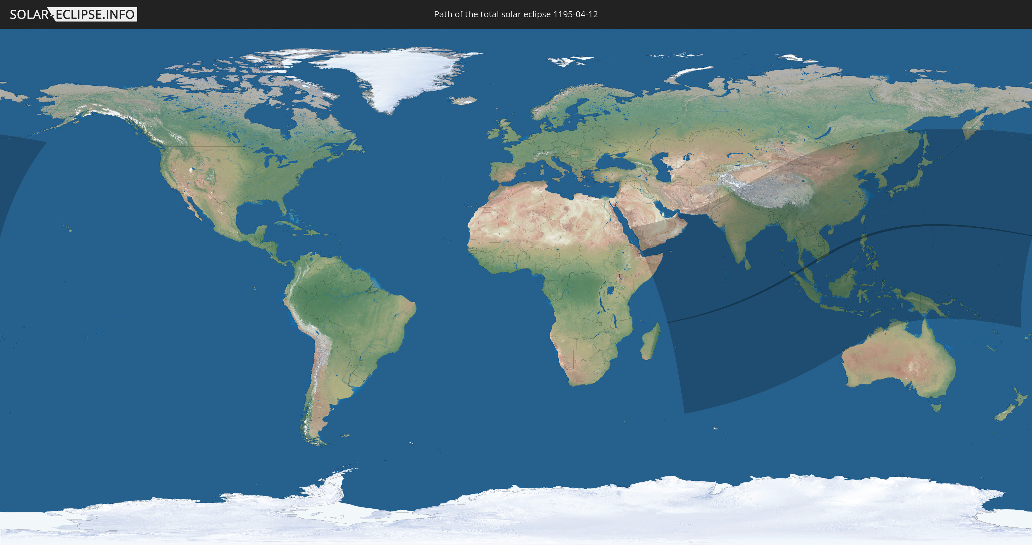
Die Sonnenfinsternis am 12.04.1195 kann man in 54 Ländern als partielle Sonnenfinsternis beobachten.
Der Finsternispfad verläuft durch 6 Länder. Nur in diesen Ländern ist sie als totale Sonnenfinsternis zu sehen.
In den folgenden Ländern ist die Sonnenfinsternis total zu sehen
 Britisches Territorium im Indischen Ozean
 Indonesien
 Thailand
 Malaysia
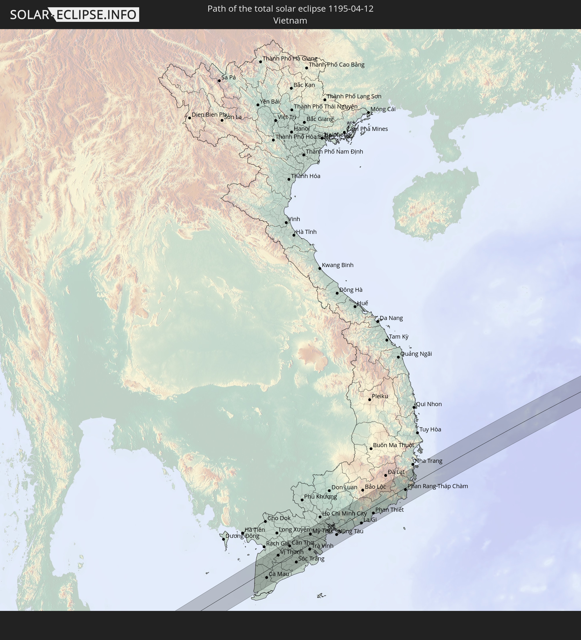 Vietnam
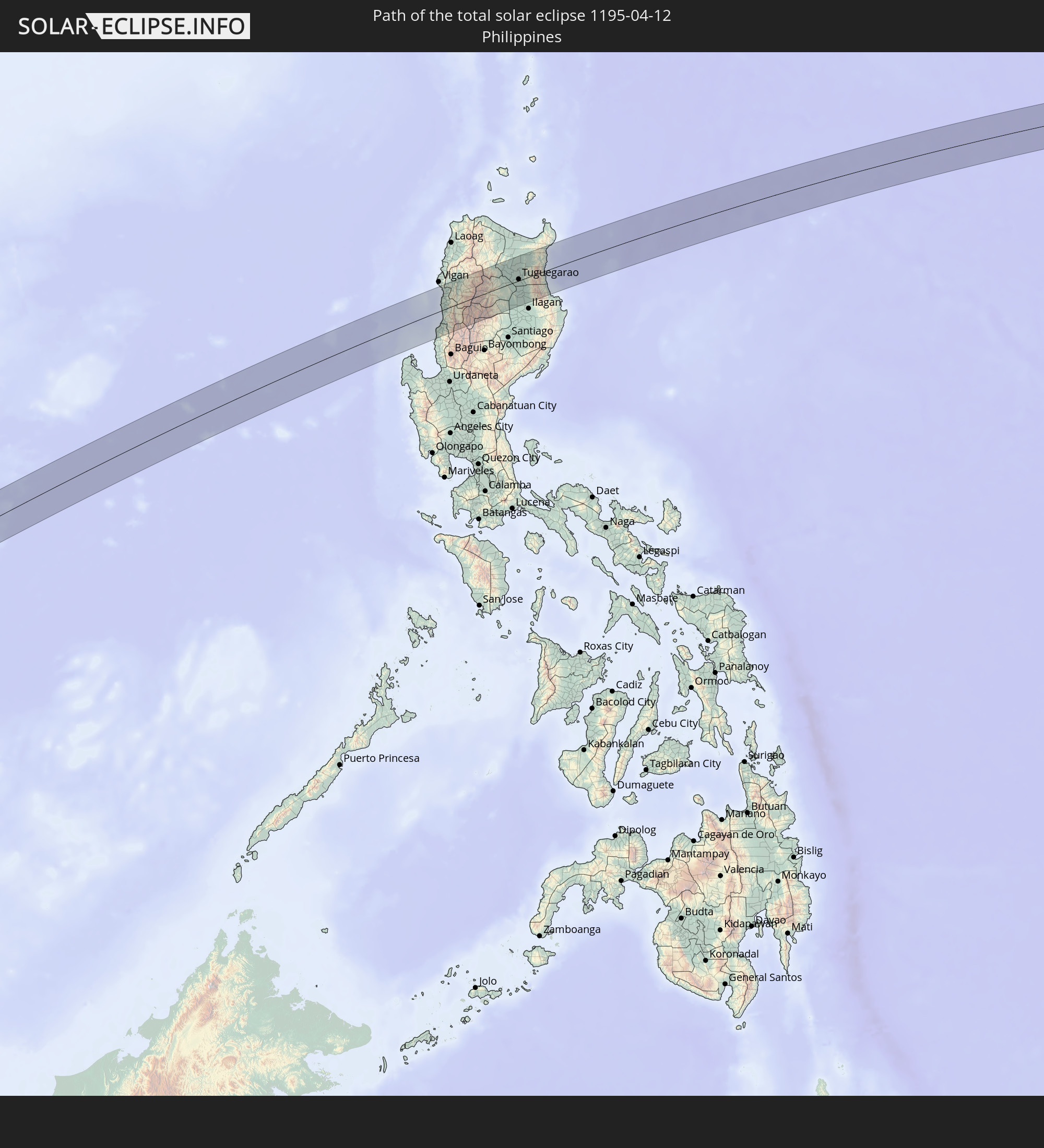 Philippinen
In den folgenden Ländern ist die Sonnenfinsternis partiell zu sehen
 Russland
 Vereinigte Staaten
 United States Minor Outlying Islands
 Kiribati
 Äthiopien
 Saudi-Arabien
 Französische Süd- und Antarktisgebiete
 Somalia
 Jemen
Jemen
 Iran
Iran
 Seychellen
 Vereinigte Arabische Emirate
 Oman
Oman
 Réunion
 Mauritius
 Pakistan
 Indien
 Britisches Territorium im Indischen Ozean
 Malediven
 Volksrepublik China
 Sri Lanka
 Nepal
Nepal
 Mongolei
 Bangladesch
 Bhutan
 Myanmar
 Indonesien
 Kokosinseln
 Thailand
 Malaysia
 Laos
Laos
 Vietnam
 Kambodscha
 Singapur
 Weihnachtsinsel
 Australien
 Macau
Macau
 Hongkong
 Brunei
 Taiwan
 Philippinen
 Japan
Japan
 Osttimor
 Nordkorea
 Südkorea
 Palau
Palau
 Föderierte Staaten von Mikronesien
 Papua-Neuguinea
 Guam
Guam
 Nördliche Marianen
 Salomonen
 Marshallinseln
 Nauru
Nauru
 Tuvalu
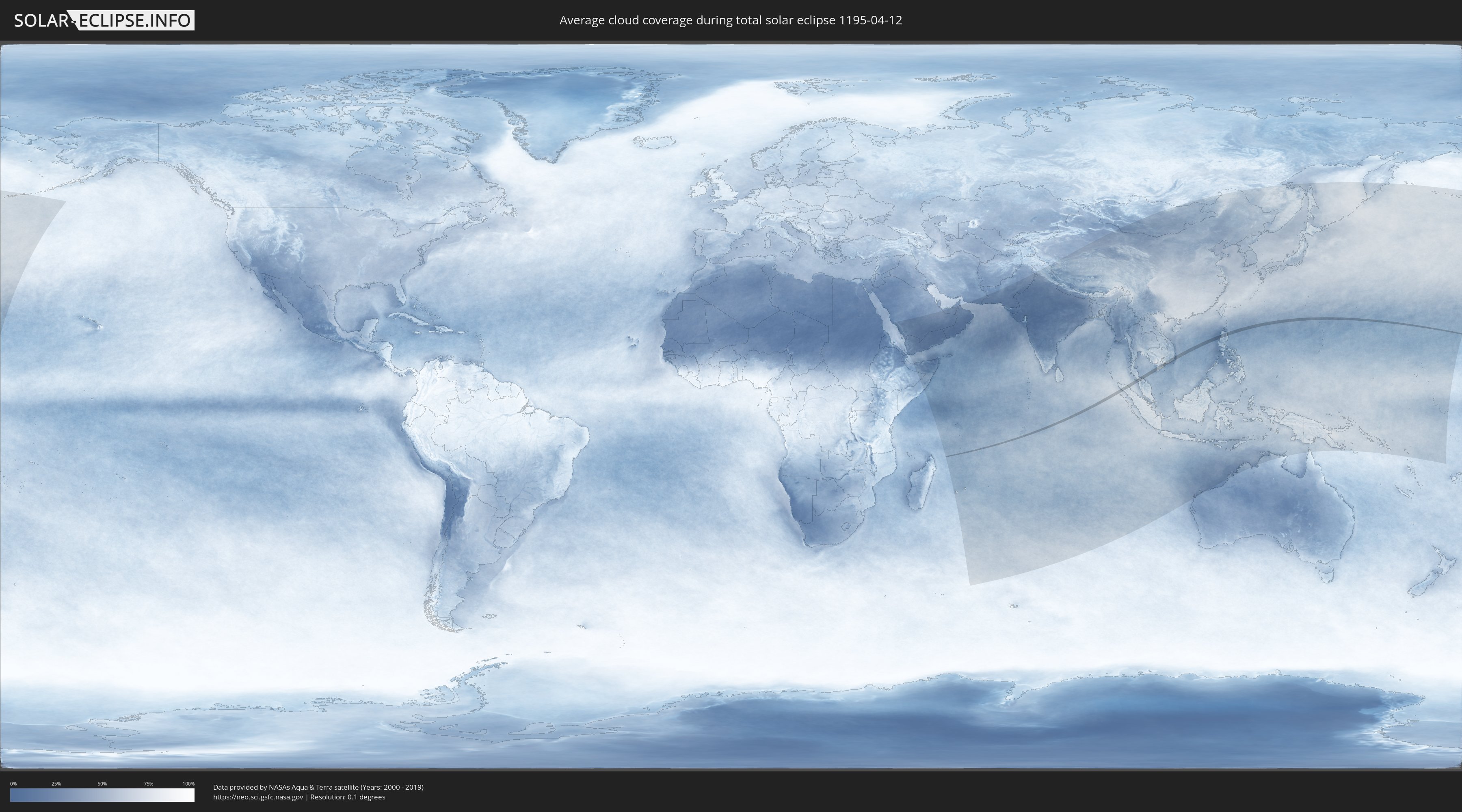
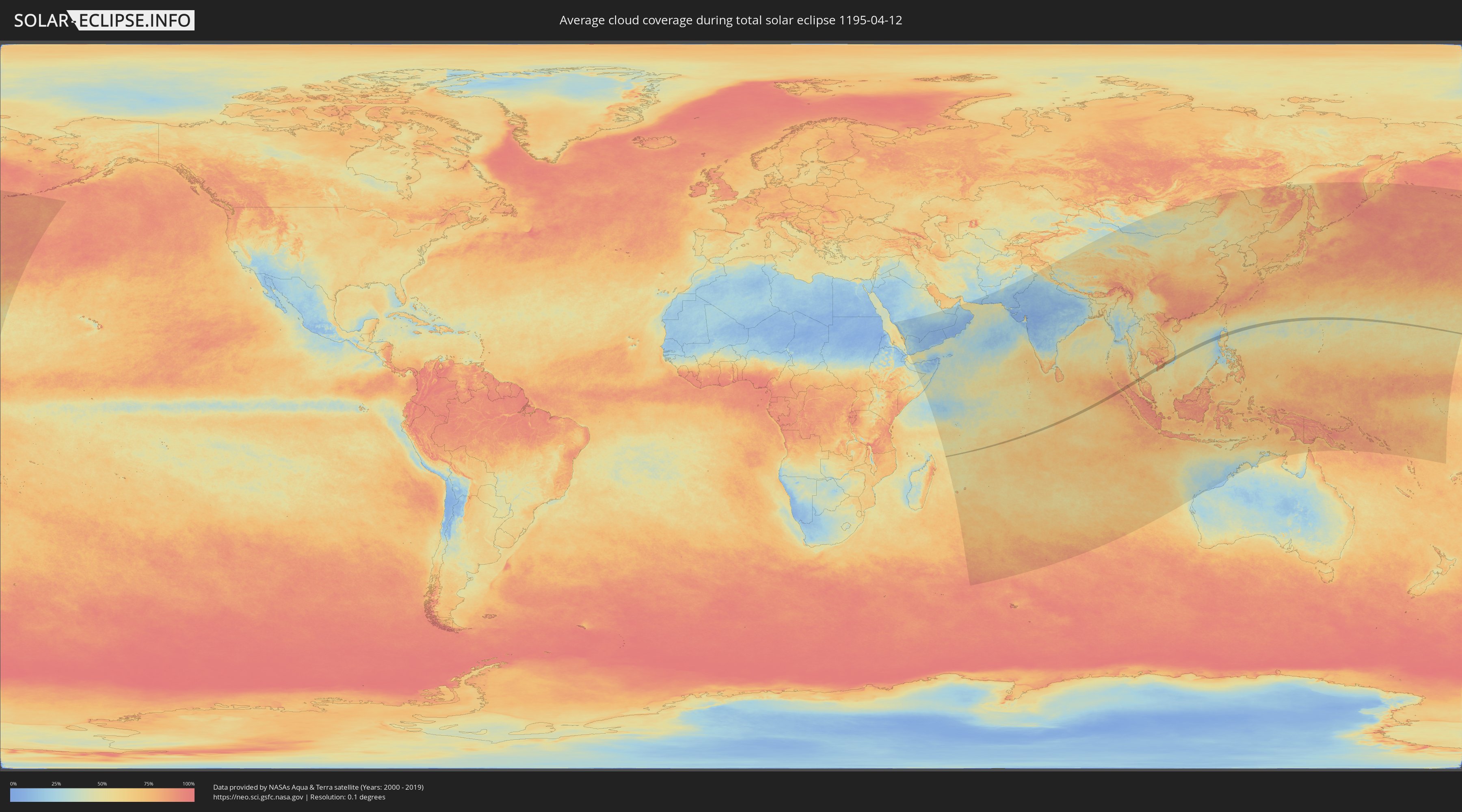
Wie wird das Wetter während der totalen Sonnenfinsternis am 12.04.1195?
Wo ist der beste Ort, um die totale Sonnenfinsternis vom 12.04.1195 zu beobachten?
Die folgenden Karten zeigen die durchschnittliche Bewölkung für den Tag, an dem die totale Sonnenfinsternis
stattfindet. Mit Hilfe der Karten lässt sich der Ort entlang des Finsternispfades eingrenzen,
der die besten Aussichen auf einen klaren wolkenfreien Himmel bietet.
Trotzdem muss man immer lokale Gegenenheiten beachten und sollte sich genau über das Wetter an seinem
gewählten Beobachtungsort informieren.
Die Daten stammen von den beiden NASA-Satelliten
AQUA und TERRA
und wurden über einen Zeitraum von 19 Jahren (2000 - 2019) gemittelt.
Detaillierte Länderkarten
 Britisches Territorium im Indischen Ozean
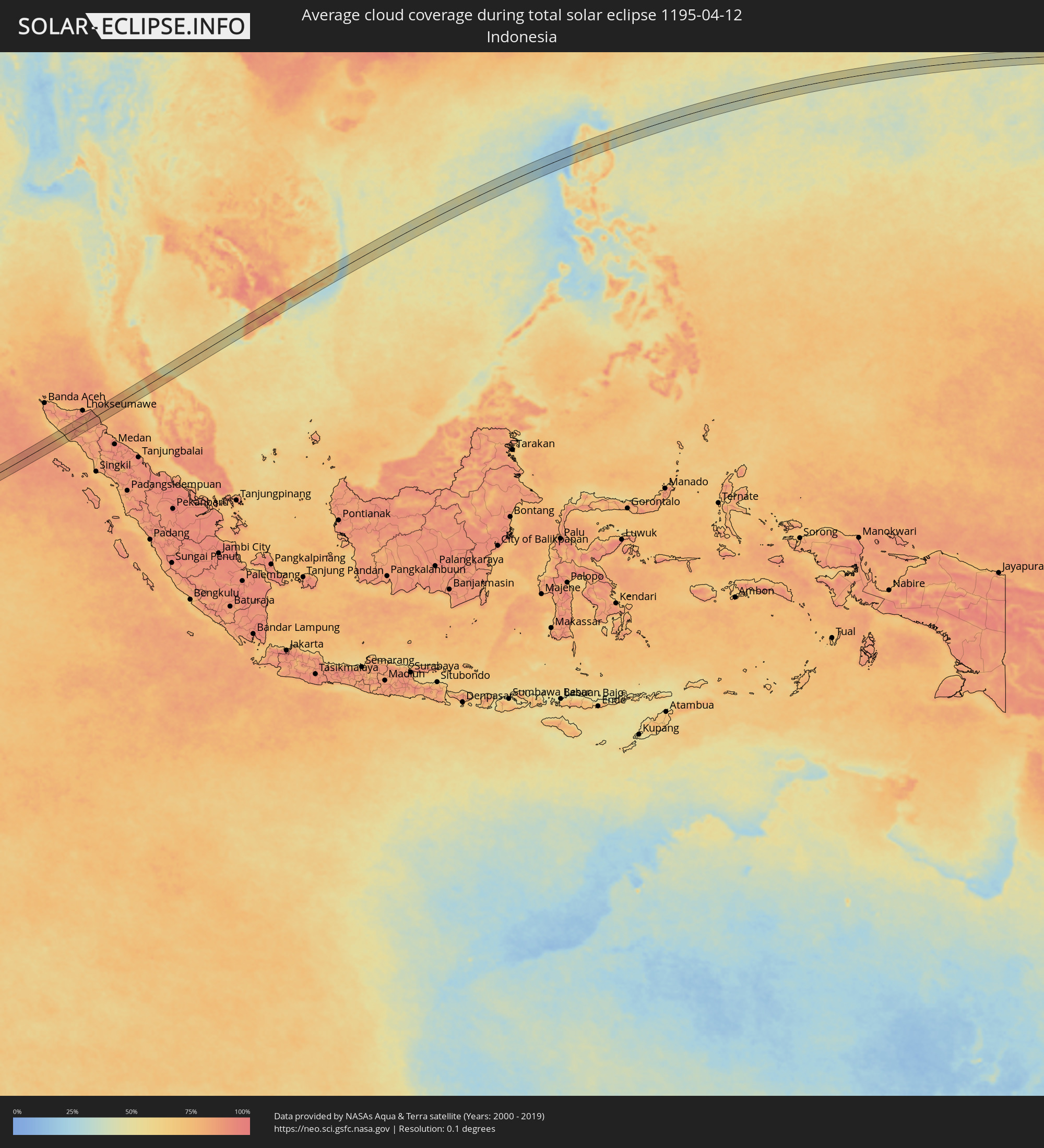 Indonesien
 Thailand
 Malaysia
 Vietnam
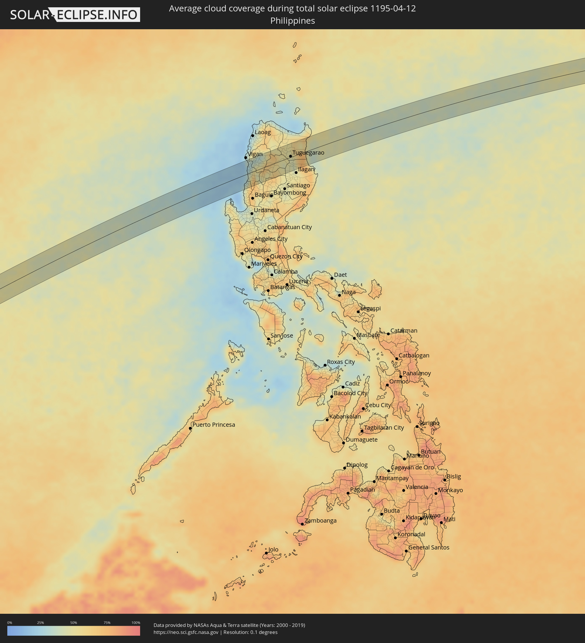 Philippinen
Orte im Finsternispfad
Die nachfolgene Tabelle zeigt Städte und Orte mit mehr als 5.000 Einwohnern, die sich im Finsternispfad befinden. Städte mit mehr als 100.000 Einwohnern sind dick gekennzeichnet. Mit einem Klick auf den Ort öffnet sich eine Detailkarte die die Lage des jeweiligen Ortes zusammen mit dem Verlauf der zentralen Finsternis präsentiert.
| Ort | Typ | Dauer der Verfinsterung | Ortszeit bei maximaler Verfinsterung | Entfernung zur Zentrallinie | Ø Bewölkung |
|
Meulaboh, Aceh
|
total | - | 10:35:22 UTC+07:07 | 19 km | 66% |
|
Pantai Cenang, Perlis
|
total | - | 10:34:39 UTC+06:55 | 19 km | 71% |
|
Padang Mat Sirat, Kedah
|
total | - | 10:34:46 UTC+06:55 | 24 km | 74% |
|
Ayer Hangat, Kedah
|
total | - | 10:35:04 UTC+06:55 | 25 km | 74% |
|
Kuah, Kedah
|
total | - | 10:34:58 UTC+06:55 | 15 km | 70% |
|
Satun, Satun
|
total | - | 10:22:36 UTC+06:42 | 30 km | 70% |
|
Kuala Perlis, Perlis
|
total | - | 10:35:45 UTC+06:55 | 5 km | 61% |
|
Kangar, Perlis
|
total | - | 10:35:58 UTC+06:55 | 6 km | 77% |
|
Kuala Kedah, Kedah
|
total | - | 10:35:39 UTC+06:55 | 33 km | 66% |
|
Alor Setar, Kedah
|
total | - | 10:35:50 UTC+06:55 | 34 km | 80% |
|
Jitra, Kedah
|
total | - | 10:36:12 UTC+06:55 | 24 km | 81% |
|
Sadao, Songkhla
|
total | - | 10:23:27 UTC+06:42 | 11 km | 72% |
|
Na Mom, Songkhla
|
total | - | 10:24:16 UTC+06:42 | 34 km | 72% |
|
Nong Chik, Pattani
|
total | - | 10:25:32 UTC+06:42 | 13 km | 79% |
|
Pattani, Pattani
|
total | - | 10:25:45 UTC+06:42 | 15 km | 69% |
|
Yaring, Pattani
|
total | - | 10:26:02 UTC+06:42 | 22 km | 63% |
|
Cà Mau, Cà Mau
|
total | - | 11:03:47 UTC+07:06 | 20 km | 81% |
|
Vị Thanh, Hau Giang
|
total | - | 11:05:36 UTC+07:06 | 20 km | 81% |
|
Thành phố Bạc Liêu, Bạc Liêu
|
total | - | 11:05:28 UTC+07:06 | 41 km | 73% |
|
Cần Thơ, Cần Thơ
|
total | - | 11:06:51 UTC+07:06 | 26 km | 78% |
|
Sóc Trăng, Sóc Trăng
|
total | - | 11:06:36 UTC+07:06 | 26 km | 89% |
|
Vĩnh Long, Vĩnh Long
|
total | - | 11:07:41 UTC+07:06 | 37 km | 73% |
|
Ấp Tân Ngãi, Bến Tre
|
total | - | 11:08:28 UTC+07:06 | 17 km | 71% |
|
Trà Vinh, Trà Vinh
|
total | - | 11:08:09 UTC+07:06 | 14 km | 90% |
|
Mỹ Tho, Tiền Giang
|
total | - | 11:08:53 UTC+07:06 | 25 km | 76% |
|
Bến Tre, Bến Tre
|
total | - | 11:08:44 UTC+07:06 | 13 km | 70% |
|
Tân An, Long An
|
total | - | 11:09:19 UTC+07:06 | 39 km | 85% |
|
Cần Giuộc, Long An
|
total | - | 11:10:07 UTC+07:06 | 31 km | 73% |
|
Cần Giờ, Ho Chi Minh City
|
total | - | 11:10:32 UTC+07:06 | 4 km | 41% |
|
Vũng Tàu, Bà Rịa-Vũng Tàu
|
total | - | 11:10:47 UTC+07:06 | 17 km | 40% |
|
Thành Phố Bà Rịa, Bà Rịa-Vũng Tàu
|
total | - | 11:11:15 UTC+07:06 | 8 km | 63% |
|
La Gi, Bình Thuận
|
total | - | 11:13:08 UTC+07:06 | 26 km | 50% |
|
Phan Thiết, Bình Thuận
|
total | - | 11:14:28 UTC+07:06 | 18 km | 42% |
|
Phan Rang-Tháp Chàm, Ninh Thuận
|
total | - | 11:17:55 UTC+07:06 | 6 km | 52% |
|
Cam Ranh, Khánh Hòa
|
total | - | 11:18:58 UTC+07:06 | 20 km | 52% |
|
Rimus, Ilocos
|
total | - | 12:51:10 UTC+08:00 | 24 km | 39% |
|
Bangar, Ilocos
|
total | - | 12:51:15 UTC+08:00 | 23 km | 39% |
|
Tagudin, Ilocos
|
total | - | 12:51:22 UTC+08:00 | 19 km | 39% |
|
Santa Maria, Ilocos
|
total | - | 12:51:23 UTC+08:00 | 18 km | 33% |
|
Candon, Ilocos
|
total | - | 12:51:41 UTC+08:00 | 7 km | 43% |
|
Suyo, Ilocos
|
total | - | 12:51:38 UTC+08:00 | 18 km | 49% |
|
Mankayan, Cordillera
|
total | - | 12:52:14 UTC+08:00 | 40 km | 49% |
|
Bontoc, Cordillera
|
total | - | 12:53:01 UTC+08:00 | 24 km | 50% |
|
Barlig, Cordillera
|
total | - | 12:53:19 UTC+08:00 | 35 km | 66% |
|
Pasil, Cordillera
|
total | - | 12:53:47 UTC+08:00 | 1 km | 59% |
|
Tabuk, Cordillera
|
total | - | 12:54:49 UTC+08:00 | 3 km | 43% |
|
Piat, Cagayan Valley
|
total | - | 12:55:11 UTC+08:00 | 30 km | 51% |
|
Quezon, Cagayan Valley
|
total | - | 12:55:01 UTC+08:00 | 25 km | 45% |
|
Muñoz East, Cagayan Valley
|
total | - | 12:54:52 UTC+08:00 | 41 km | 47% |
|
Liwan, Cordillera
|
total | - | 12:55:19 UTC+08:00 | 4 km | 48% |
|
Bauan, Cagayan Valley
|
total | - | 12:55:40 UTC+08:00 | 15 km | 44% |
|
Solana, Cagayan Valley
|
total | - | 12:55:37 UTC+08:00 | 7 km | 44% |
|
Atulayan, Cagayan Valley
|
total | - | 12:55:38 UTC+08:00 | 8 km | 44% |
|
Enrile, Cagayan Valley
|
total | - | 12:55:32 UTC+08:00 | 3 km | 44% |
|
Nattapian, Cagayan Valley
|
total | - | 12:55:40 UTC+08:00 | 9 km | 44% |
|
Dassun, Cagayan Valley
|
total | - | 12:55:46 UTC+08:00 | 16 km | 44% |
|
Tuguegarao, Cagayan Valley
|
total | - | 12:55:40 UTC+08:00 | 2 km | 44% |
|
Cabagan, Cagayan Valley
|
total | - | 12:55:36 UTC+08:00 | 19 km | 42% |