Totale Sonnenfinsternis vom 05.07.1274
| Wochentag: | Donnerstag |
| Maximale Dauer der Verfinsterung: | 06m35s |
| Maximale Breite des Finsternispfades: | 278 km |
| Saroszyklus: | 105 |
| Bedeckungsgrad: | 100% |
| Magnitude: | 1.07 |
| Gamma: | -0.5742 |
Wo kann man die Sonnenfinsternis vom 05.07.1274 sehen?

Die Sonnenfinsternis am 05.07.1274 kann man in 54 Ländern als partielle Sonnenfinsternis beobachten.
Der Finsternispfad verläuft durch 8 Länder. Nur in diesen Ländern ist sie als totale Sonnenfinsternis zu sehen.
In den folgenden Ländern ist die Sonnenfinsternis total zu sehen
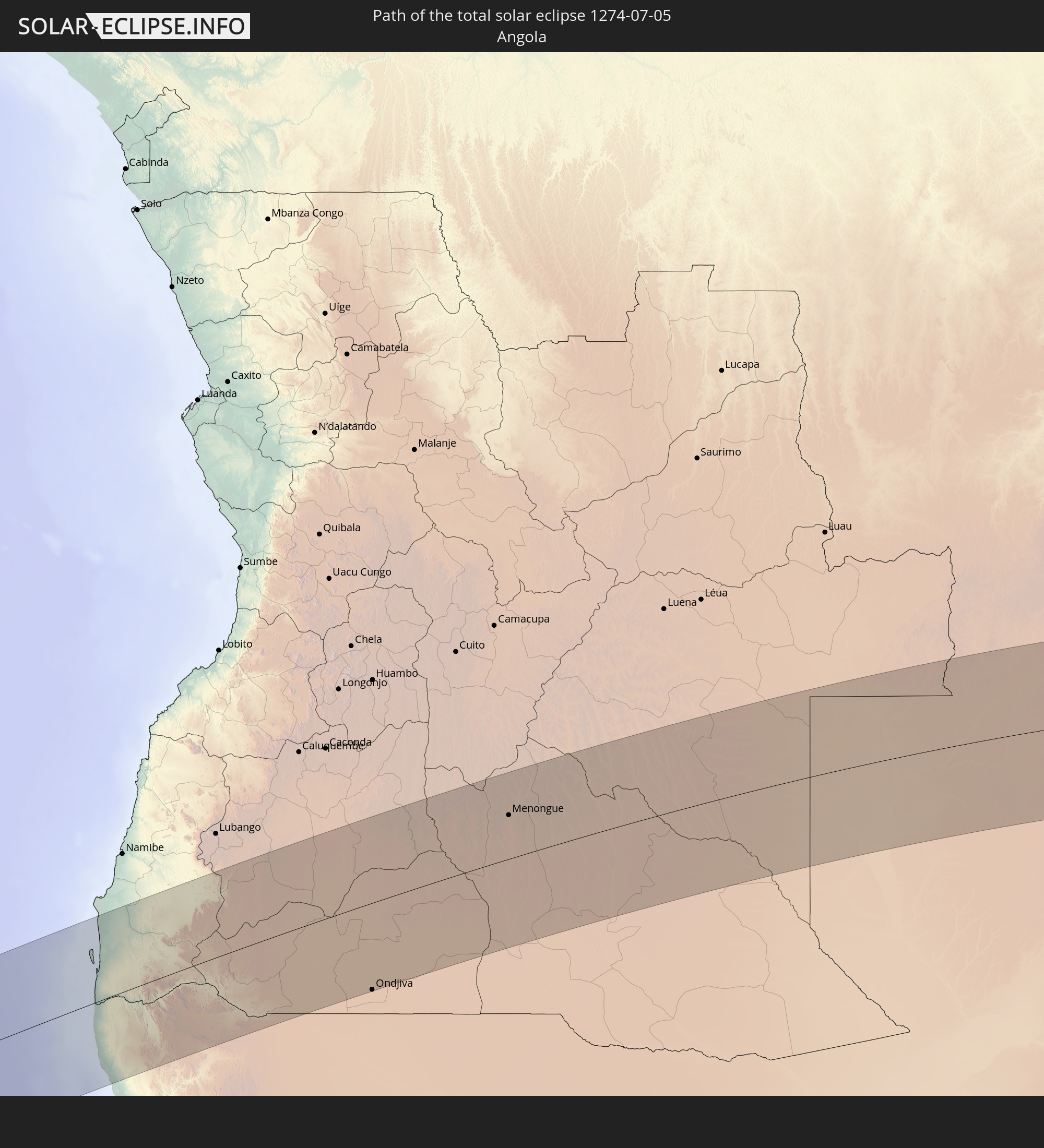 Angola
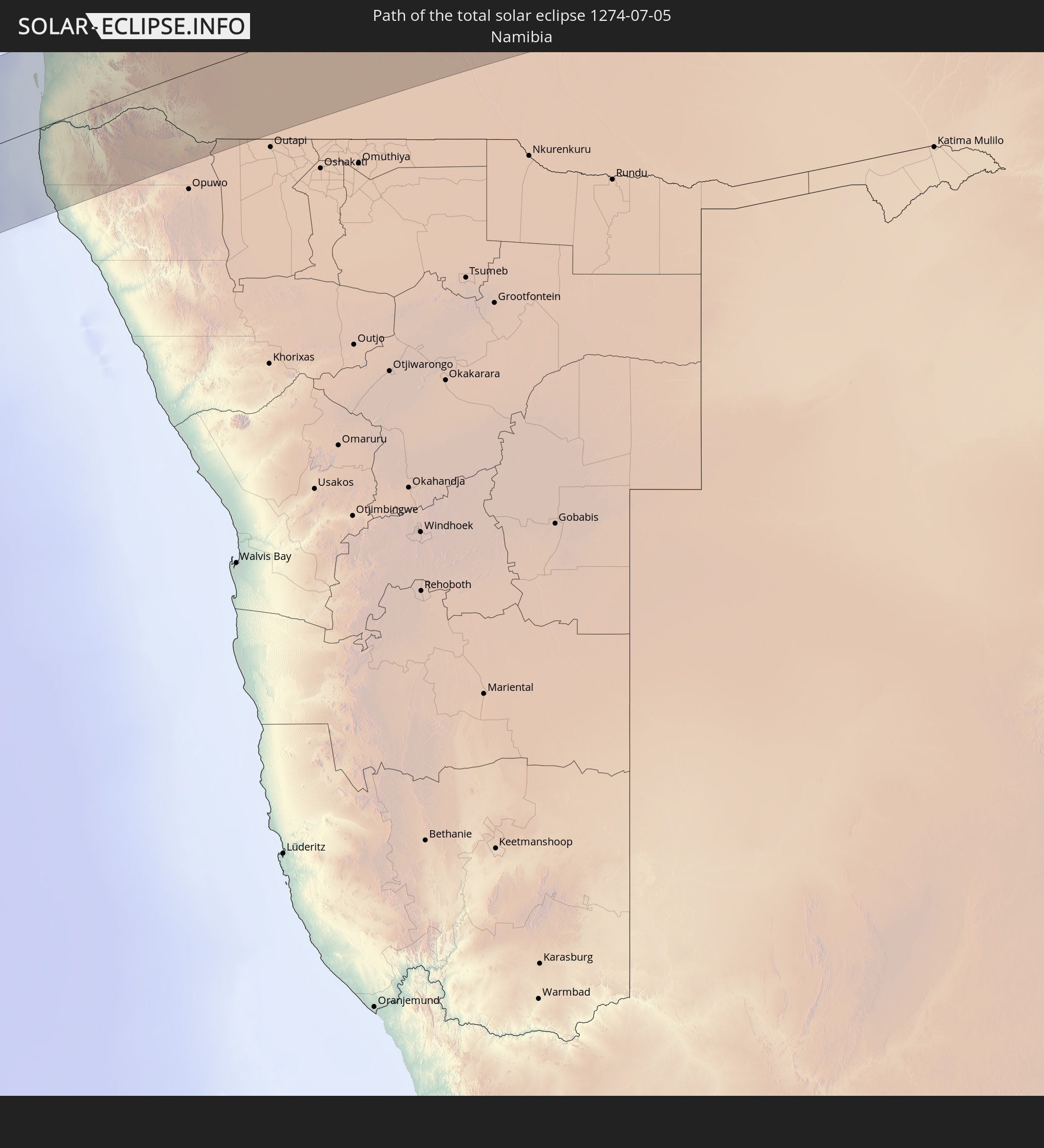 Namibia
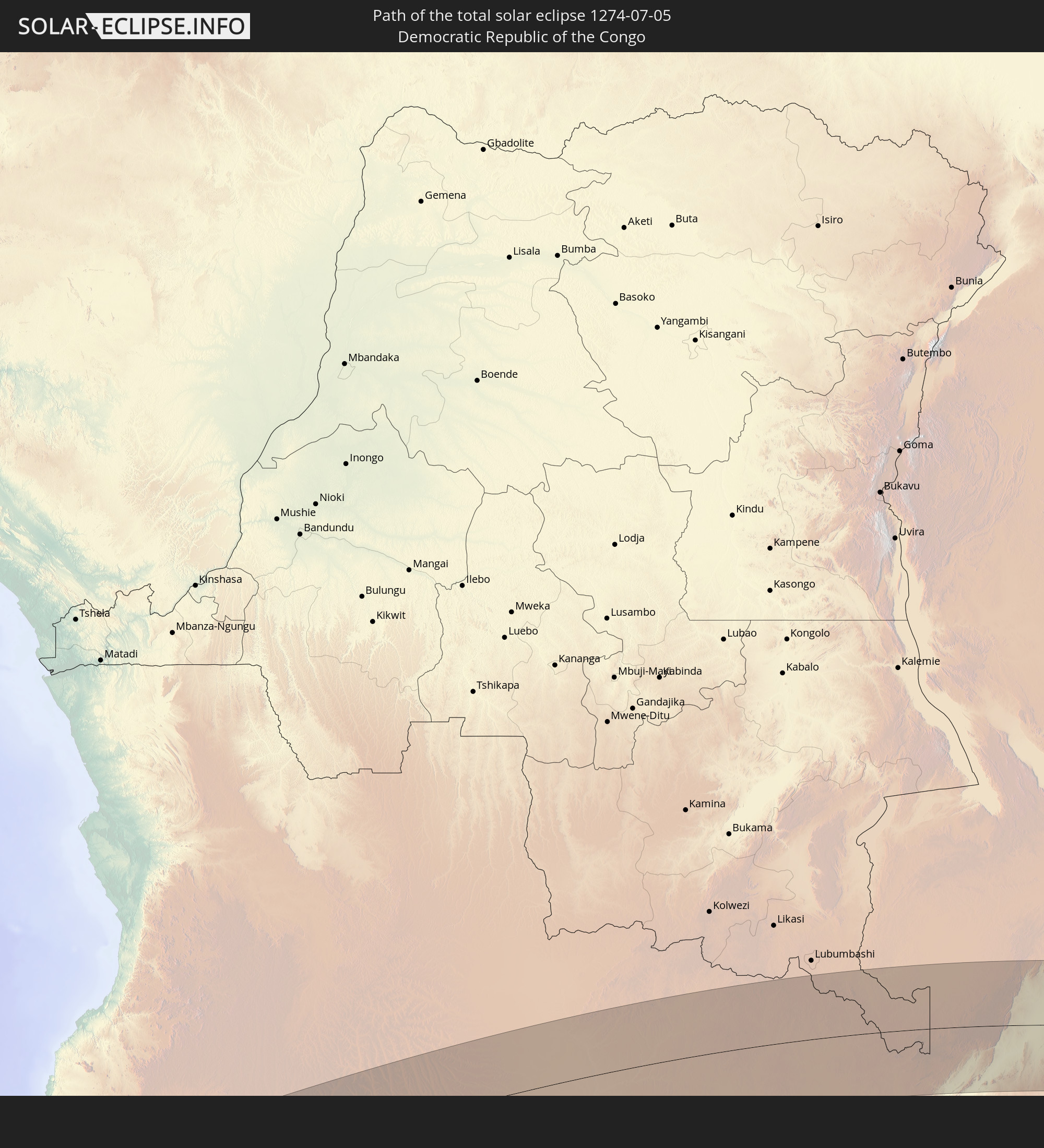 Demokratische Republik Kongo
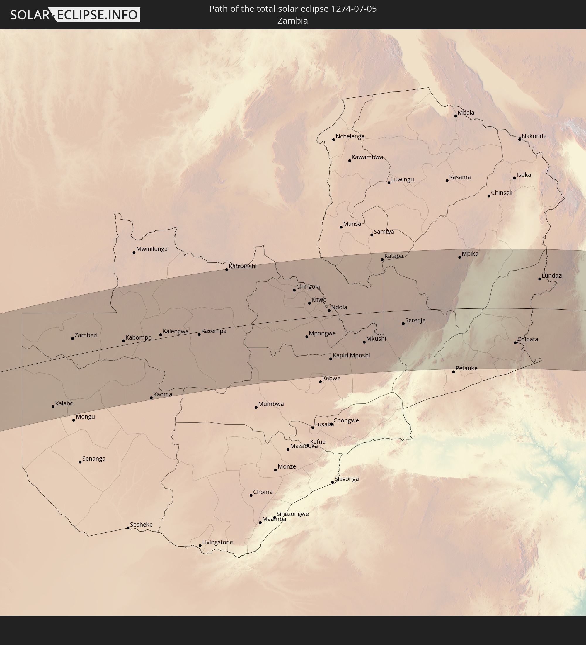 Sambia
 Mosambik
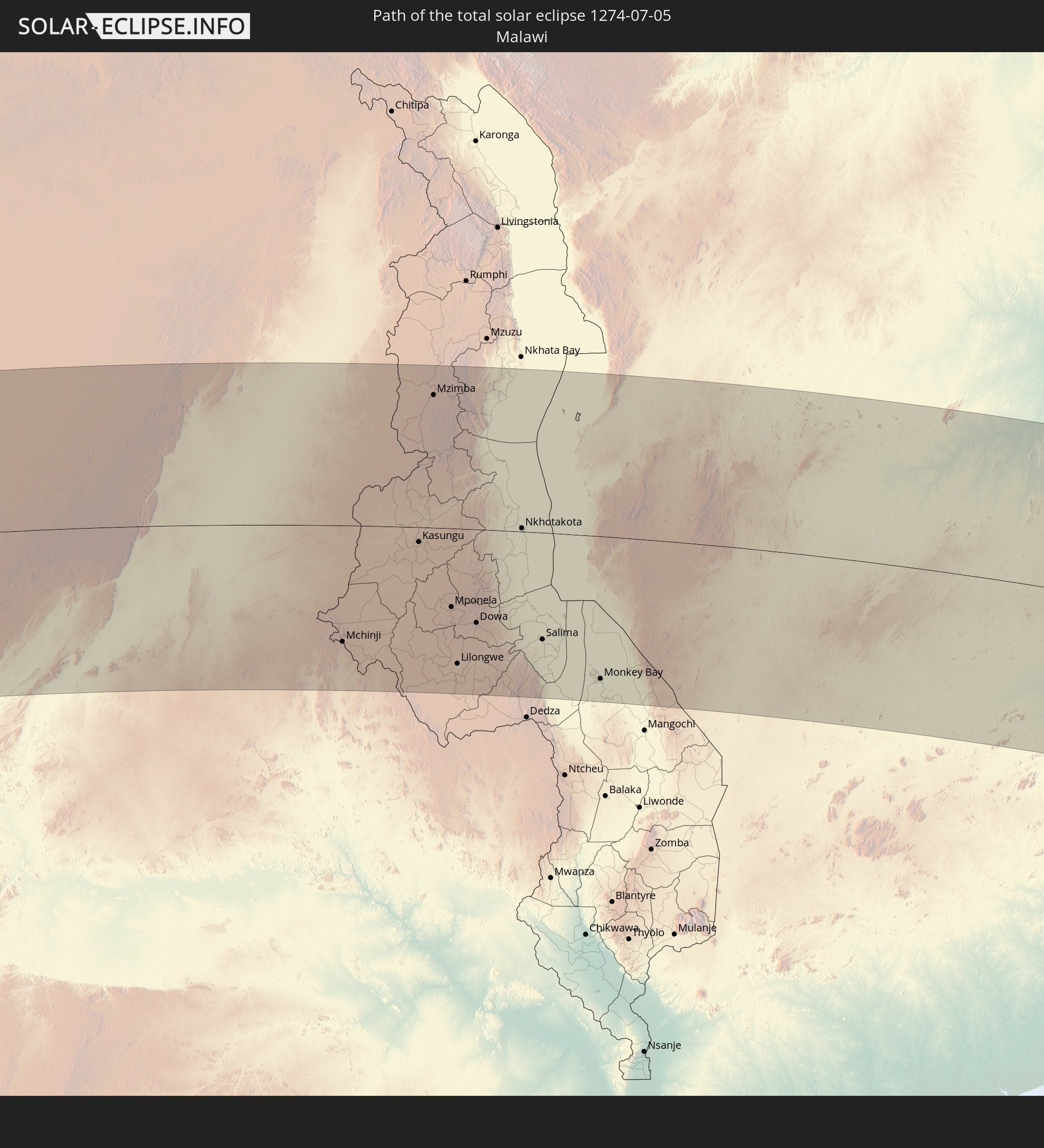 Malawi
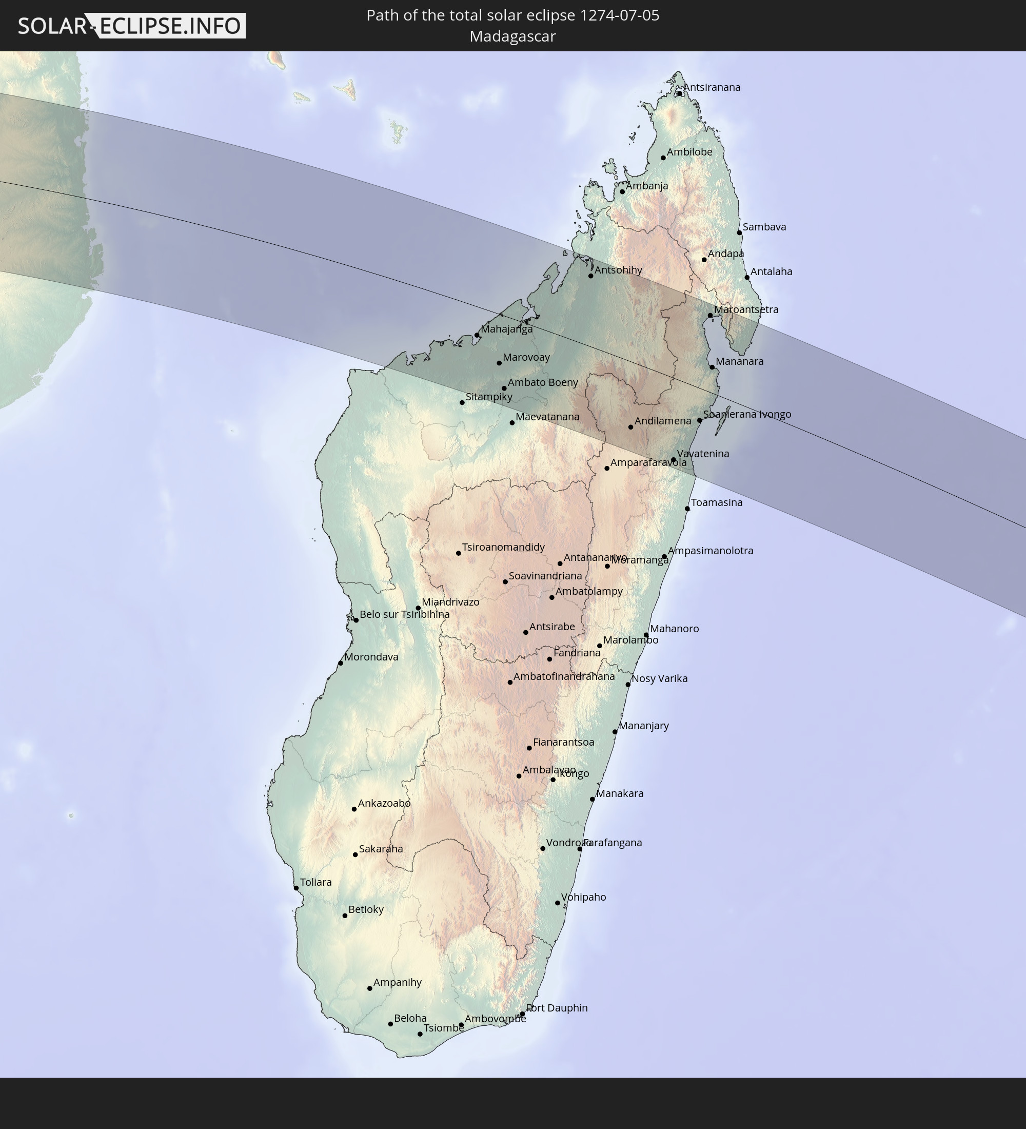 Madagaskar
 Mauritius
In den folgenden Ländern ist die Sonnenfinsternis partiell zu sehen
 Antarktika
 Guinea
 St. Helena
 Sierra Leone
 Liberia
 Elfenbeinküste
 Burkina Faso
 Ghana
Ghana
 Togo
Togo
 Niger
Niger
 Benin
Benin
 Nigeria
 Bouvetinsel
 Äquatorialguinea
 São Tomé und Príncipe
 Kamerun
 Gabun
Gabun
 Republik Kongo
 Angola
 Namibia
 Demokratische Republik Kongo
 Tschad
 Zentralafrikanische Republik
 Südafrika
 Botswana
 Sudan
Sudan
 Sambia
 Simbabwe
 Lesotho
 Ruanda
 Burundi
 Tansania
 Uganda
 Mosambik
 Swasiland
 Malawi
 Äthiopien
 Kenia
Kenia
 Saudi-Arabien
 Eritrea
 Französische Süd- und Antarktisgebiete
 Somalia
 Dschibuti
 Jemen
Jemen
 Madagaskar
 Komoren
 Mayotte
 Seychellen
 Réunion
 Mauritius
 Britisches Territorium im Indischen Ozean
 Heard und McDonaldinseln
 Malediven
 Kokosinseln
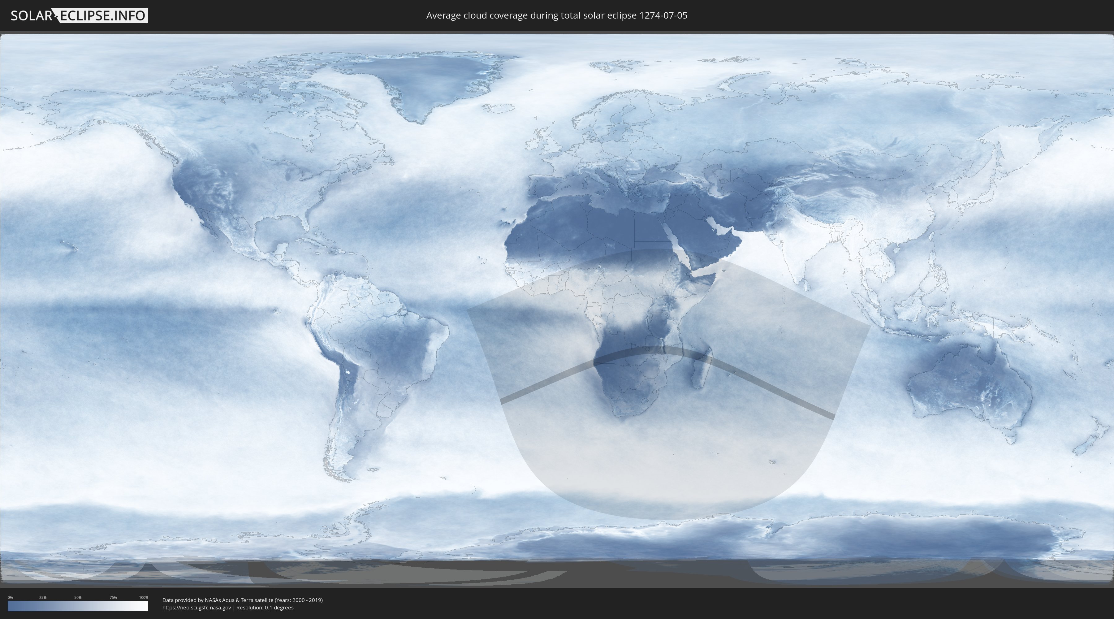
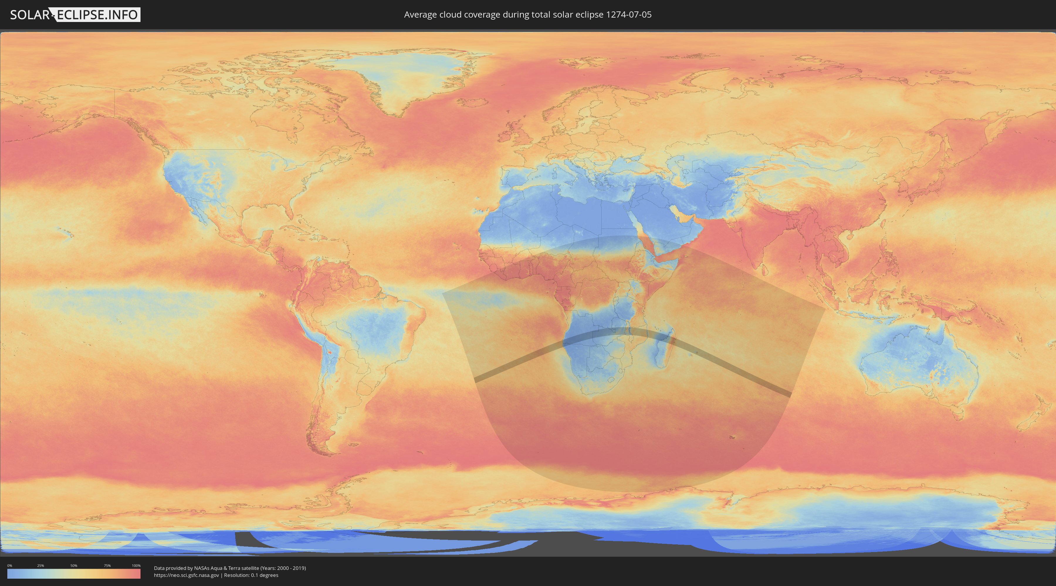
Wie wird das Wetter während der totalen Sonnenfinsternis am 05.07.1274?
Wo ist der beste Ort, um die totale Sonnenfinsternis vom 05.07.1274 zu beobachten?
Die folgenden Karten zeigen die durchschnittliche Bewölkung für den Tag, an dem die totale Sonnenfinsternis
stattfindet. Mit Hilfe der Karten lässt sich der Ort entlang des Finsternispfades eingrenzen,
der die besten Aussichen auf einen klaren wolkenfreien Himmel bietet.
Trotzdem muss man immer lokale Gegenenheiten beachten und sollte sich genau über das Wetter an seinem
gewählten Beobachtungsort informieren.
Die Daten stammen von den beiden NASA-Satelliten
AQUA und TERRA
und wurden über einen Zeitraum von 19 Jahren (2000 - 2019) gemittelt.
Detaillierte Länderkarten
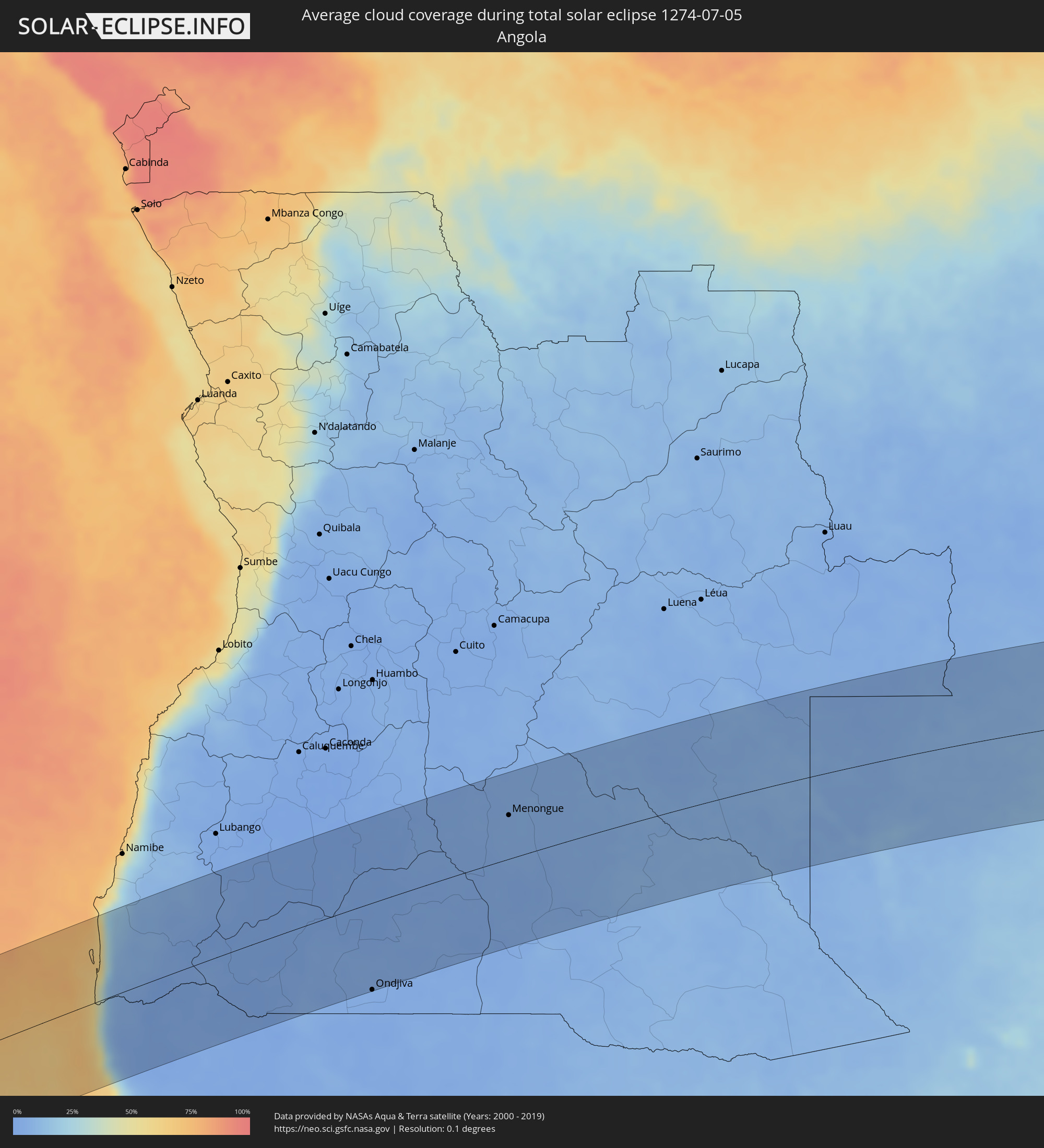 Angola
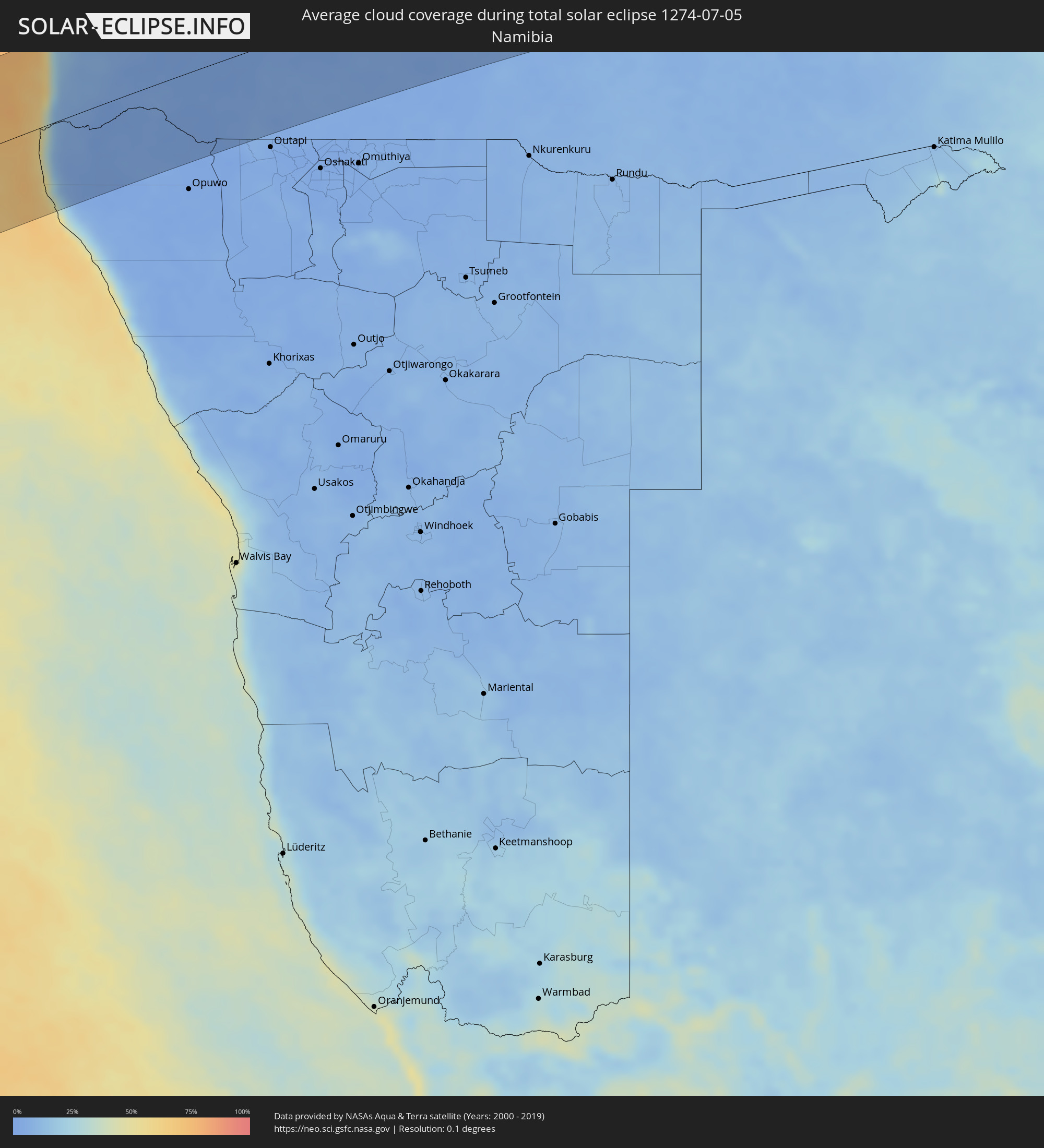 Namibia
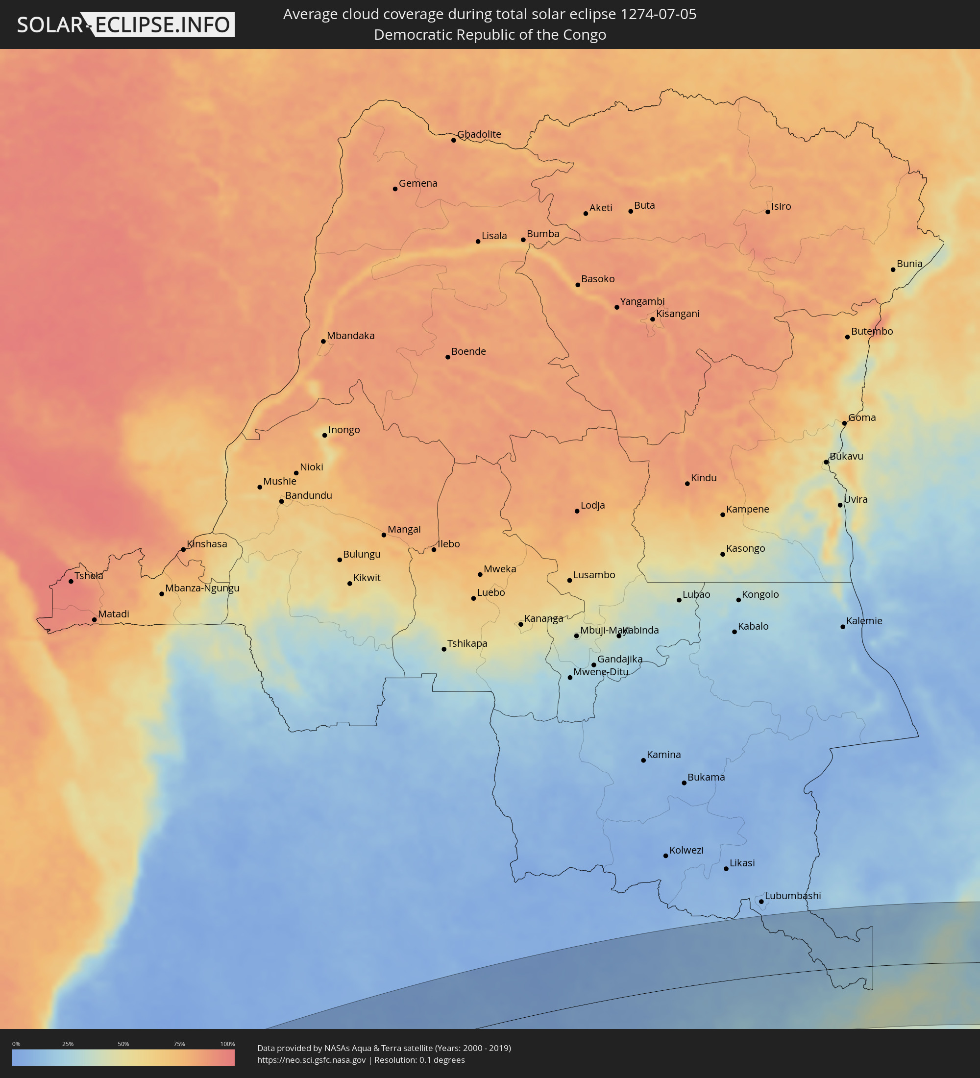 Demokratische Republik Kongo
 Sambia
 Mosambik
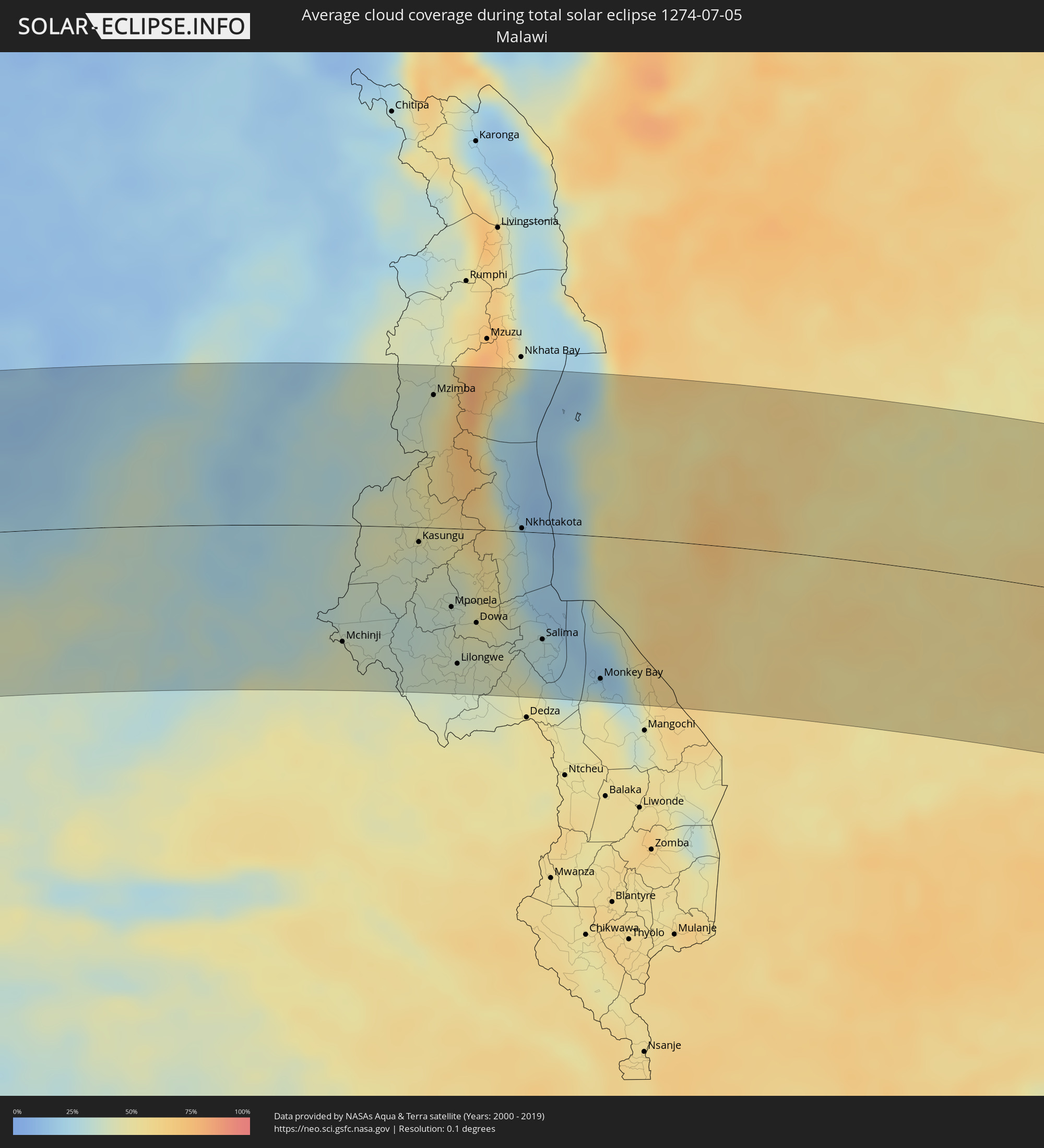 Malawi
 Madagaskar
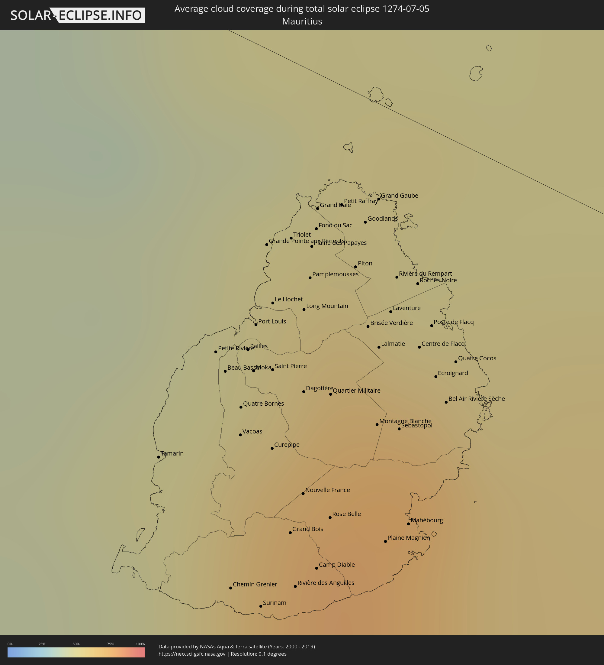 Mauritius
Orte im Finsternispfad
Die nachfolgene Tabelle zeigt Städte und Orte mit mehr als 5.000 Einwohnern, die sich im Finsternispfad befinden. Städte mit mehr als 100.000 Einwohnern sind dick gekennzeichnet. Mit einem Klick auf den Ort öffnet sich eine Detailkarte die die Lage des jeweiligen Ortes zusammen mit dem Verlauf der zentralen Finsternis präsentiert.
| Ort | Typ | Dauer der Verfinsterung | Ortszeit bei maximaler Verfinsterung | Entfernung zur Zentrallinie | Ø Bewölkung |
|
Ondjiva, Cunene
|
total | - | 08:55:12 UTC+00:13 | 126 km | 3% |
|
Menongue, Cuando Cobango
|
total | - | 08:58:54 UTC+00:13 | 65 km | 5% |
|
Kalabo, Western
|
total | - | 11:08:09 UTC+02:10 | 108 km | 7% |
|
Zambezi, North-Western
|
total | - | 11:08:57 UTC+02:10 | 38 km | 5% |
|
Limulunga, Western
|
total | - | 11:09:24 UTC+02:10 | 132 km | 12% |
|
Kaoma, Western
|
total | - | 11:13:53 UTC+02:10 | 133 km | 11% |
|
Mufumbwe, North-Western
|
total | - | 11:13:38 UTC+02:10 | 13 km | 8% |
|
Kalengwa, North-Western
|
total | - | 11:14:09 UTC+02:10 | 7 km | 10% |
|
Kasempa, North-Western
|
total | - | 11:16:30 UTC+02:10 | 6 km | 12% |
|
Solwezi, North-Western
|
total | - | 11:17:50 UTC+02:10 | 127 km | 11% |
|
Kansanshi, North-Western
|
total | - | 11:17:56 UTC+02:10 | 134 km | 10% |
|
Kalulushi, Copperbelt
|
total | - | 11:22:58 UTC+02:10 | 30 km | 12% |
|
Mpongwe, Copperbelt
|
total | - | 11:23:17 UTC+02:10 | 44 km | 17% |
|
Kitwe, Copperbelt
|
total | - | 11:23:18 UTC+02:10 | 33 km | 11% |
|
Mufulira, Copperbelt
|
total | - | 11:23:20 UTC+02:10 | 61 km | 12% |
|
Luanshya, Copperbelt
|
total | - | 11:23:59 UTC+02:10 | 6 km | 14% |
|
Ndola, Copperbelt
|
total | - | 11:24:36 UTC+02:10 | 12 km | 16% |
|
Kapiri Mposhi, Central
|
total | - | 11:24:55 UTC+02:10 | 101 km | 27% |
|
Mkushi, Central
|
total | - | 11:27:01 UTC+02:10 | 69 km | 27% |
|
Kataba, Copperbelt
|
total | - | 11:27:50 UTC+02:10 | 122 km | 13% |
|
Serenje, Central
|
total | - | 11:29:29 UTC+02:10 | 31 km | 31% |
|
Mpika, Muchinga Province
|
total | - | 11:32:56 UTC+02:10 | 120 km | 27% |
|
Mchinji, Central Region
|
total | - | 11:37:47 UTC+02:10 | 99 km | 42% |
|
Lundazi, Eastern
|
total | - | 11:38:23 UTC+02:10 | 69 km | 36% |
|
Kasungu, Central Region
|
total | - | 11:39:29 UTC+02:10 | 13 km | 39% |
|
Mzimba, Northern Region
|
total | - | 11:39:36 UTC+02:10 | 114 km | 42% |
|
Mponela, Central Region
|
total | - | 11:40:24 UTC+02:10 | 67 km | 36% |
|
Lilongwe, Central Region
|
total | - | 11:40:39 UTC+02:10 | 115 km | 38% |
|
Ntchisi, Central Region
|
total | - | 11:40:57 UTC+02:10 | 66 km | 44% |
|
Dowa, Central Region
|
total | - | 11:41:03 UTC+02:10 | 80 km | 42% |
|
Nkhotakota, Central Region
|
total | - | 11:42:00 UTC+02:10 | 3 km | 27% |
|
Salima, Central Region
|
total | - | 11:42:42 UTC+02:10 | 91 km | 27% |
|
Monkey Bay, Southern Region
|
total | - | 11:44:12 UTC+02:10 | 121 km | 36% |
|
Lichinga, Niassa
|
total | - | 11:45:03 UTC+02:10 | 33 km | 54% |
|
Montepuez, Cabo Delgado
|
total | - | 11:56:41 UTC+02:10 | 38 km | 57% |
|
Pemba, Cabo Delgado
|
total | - | 12:01:17 UTC+02:10 | 85 km | 43% |
|
Nacala, Nampula
|
total | - | 12:02:08 UTC+02:10 | 84 km | 56% |
|
Ilha de Moçambique, Nampula
|
total | - | 12:02:23 UTC+02:10 | 134 km | 42% |
|
Mahajanga, Boeny
|
total | - | 12:35:28 UTC+02:27 | 43 km | 16% |
|
Marovoay, Boeny
|
total | - | 12:36:25 UTC+02:27 | 73 km | 29% |
|
Ambato Boeny, Boeny
|
total | - | 12:36:39 UTC+02:27 | 108 km | 21% |
|
Tsaratanana, Betsiboka
|
total | - | 12:39:11 UTC+02:27 | 109 km | 41% |
|
Antsohihy, Sofia
|
total | - | 12:39:47 UTC+02:27 | 104 km | 25% |
|
Bemaitso, Alaotra Mangoro
|
total | - | 12:41:24 UTC+02:27 | 105 km | 76% |
|
Andilamena, Alaotra Mangoro
|
total | - | 12:41:35 UTC+02:27 | 96 km | 76% |
|
Antsirabe Afovoany, Sofia
|
total | - | 12:42:28 UTC+02:27 | 29 km | 78% |
|
Sahatavy, Analanjirofo
|
total | - | 12:42:43 UTC+02:27 | 126 km | 81% |
|
Vohibinany, Atsinanana
|
total | - | 12:42:47 UTC+02:27 | 114 km | 80% |
|
Vavatenina, Analanjirofo
|
total | - | 12:43:13 UTC+02:27 | 119 km | 77% |
|
Fenoarivo Atsinanana, Analanjirofo
|
total | - | 12:43:44 UTC+02:27 | 102 km | 67% |
|
Mahavelona, Atsinanana
|
total | - | 12:44:01 UTC+02:27 | 130 km | 66% |
|
Soanierana Ivongo, Analanjirofo
|
total | - | 12:44:08 UTC+02:27 | 48 km | 70% |
|
Maroantsetra, Analanjirofo
|
total | - | 12:44:21 UTC+02:27 | 112 km | 71% |
|
Mananara, Analanjirofo
|
total | - | 12:44:30 UTC+02:27 | 37 km | 65% |
|
Antakotako, Analanjirofo
|
total | - | 12:44:29 UTC+02:27 | 127 km | 78% |
|
Ambodifotatra, Analanjirofo
|
total | - | 12:44:48 UTC+02:27 | 44 km | 67% |
|
Chemin Grenier, Savanne
|
total | - | 14:24:15 UTC+03:50 | 69 km | 63% |
|
Vacoas, Plaines Wilhems
|
total | - | 14:24:17 UTC+03:50 | 49 km | 68% |
|
Moka, Moka
|
total | - | 14:24:20 UTC+03:50 | 41 km | 64% |
|
Port Louis, Port Louis
|
total | - | 14:24:21 UTC+03:50 | 35 km | 64% |
|
Surinam, Savanne
|
total | - | 14:24:19 UTC+03:50 | 69 km | 63% |
|
Grande Pointe aux Piments, Pamplemousses
|
total | - | 14:24:23 UTC+03:50 | 24 km | 55% |
|
Terre Rouge, Pamplemousses
|
total | - | 14:24:24 UTC+03:50 | 30 km | 55% |
|
Grand Bois, Savanne
|
total | - | 14:24:24 UTC+03:50 | 58 km | 71% |
|
Rivière des Anguilles, Savanne
|
total | - | 14:24:25 UTC+03:50 | 65 km | 63% |
|
Morcellemont Saint André, Pamplemousses
|
total | - | 14:24:28 UTC+03:50 | 23 km | 65% |
|
Nouvelle France, Grand Port
|
total | - | 14:24:27 UTC+03:50 | 53 km | 75% |
|
Dagotière, Moka
|
total | - | 14:24:27 UTC+03:50 | 40 km | 74% |
|
Long Mountain, Pamplemousses
|
total | - | 14:24:28 UTC+03:50 | 30 km | 65% |
|
Pamplemousses, Pamplemousses
|
total | - | 14:24:29 UTC+03:50 | 26 km | 65% |
|
Plaine des Papayes, Pamplemousses
|
total | - | 14:24:30 UTC+03:50 | 22 km | 65% |
|
Fond du Sac, Pamplemousses
|
total | - | 14:24:30 UTC+03:50 | 19 km | 57% |
|
Quartier Militaire, Moka
|
total | - | 14:24:31 UTC+03:50 | 39 km | 74% |
|
Petit Raffray, Rivière du Rempart
|
total | - | 14:24:34 UTC+03:50 | 15 km | 57% |
|
New Grove, Grand Port
|
total | - | 14:24:32 UTC+03:50 | 54 km | 75% |
|
Piton, Rivière du Rempart
|
total | - | 14:24:36 UTC+03:50 | 22 km | 65% |
|
Goodlands, Rivière du Rempart
|
total | - | 14:24:38 UTC+03:50 | 16 km | 57% |
|
Brisée Verdière, Flacq
|
total | - | 14:24:38 UTC+03:50 | 28 km | 74% |
|
Bon Accueil, Flacq
|
total | - | 14:24:39 UTC+03:50 | 28 km | 74% |
|
Montagne Blanche
|
total | - | 14:24:38 UTC+03:50 | 40 km | 72% |
|
Grand Gaube, Rivière du Rempart
|
total | - | 14:24:40 UTC+03:50 | 12 km | 52% |
|
Lalmatie, Flacq
|
total | - | 14:24:39 UTC+03:50 | 30 km | 74% |
|
Laventure, Flacq
|
total | - | 14:24:41 UTC+03:50 | 25 km | 63% |
|
Sebastopol, Flacq
|
total | - | 14:24:42 UTC+03:50 | 39 km | 72% |
|
Beau Vallon, Grand Port
|
total | - | 14:24:42 UTC+03:50 | 51 km | 66% |
|
Mahébourg, Grand Port
|
total | - | 14:24:42 UTC+03:50 | 50 km | 66% |
|
Roches Noire, Rivière du Rempart
|
total | - | 14:24:45 UTC+03:50 | 20 km | 63% |
|
Centre de Flacq, Flacq
|
total | - | 14:24:45 UTC+03:50 | 28 km | 74% |
|
Poste de Flacq, Flacq
|
total | - | 14:24:47 UTC+03:50 | 24 km | 74% |
|
Ecroignard, Flacq
|
total | - | 14:24:47 UTC+03:50 | 30 km | 74% |