Totale Sonnenfinsternis vom 12.01.1404
| Wochentag: | Donnerstag |
| Maximale Dauer der Verfinsterung: | 02m58s |
| Maximale Breite des Finsternispfades: | 279 km |
| Saroszyklus: | 102 |
| Bedeckungsgrad: | 100% |
| Magnitude: | 1.0369 |
| Gamma: | 0.8945 |
Wo kann man die Sonnenfinsternis vom 12.01.1404 sehen?
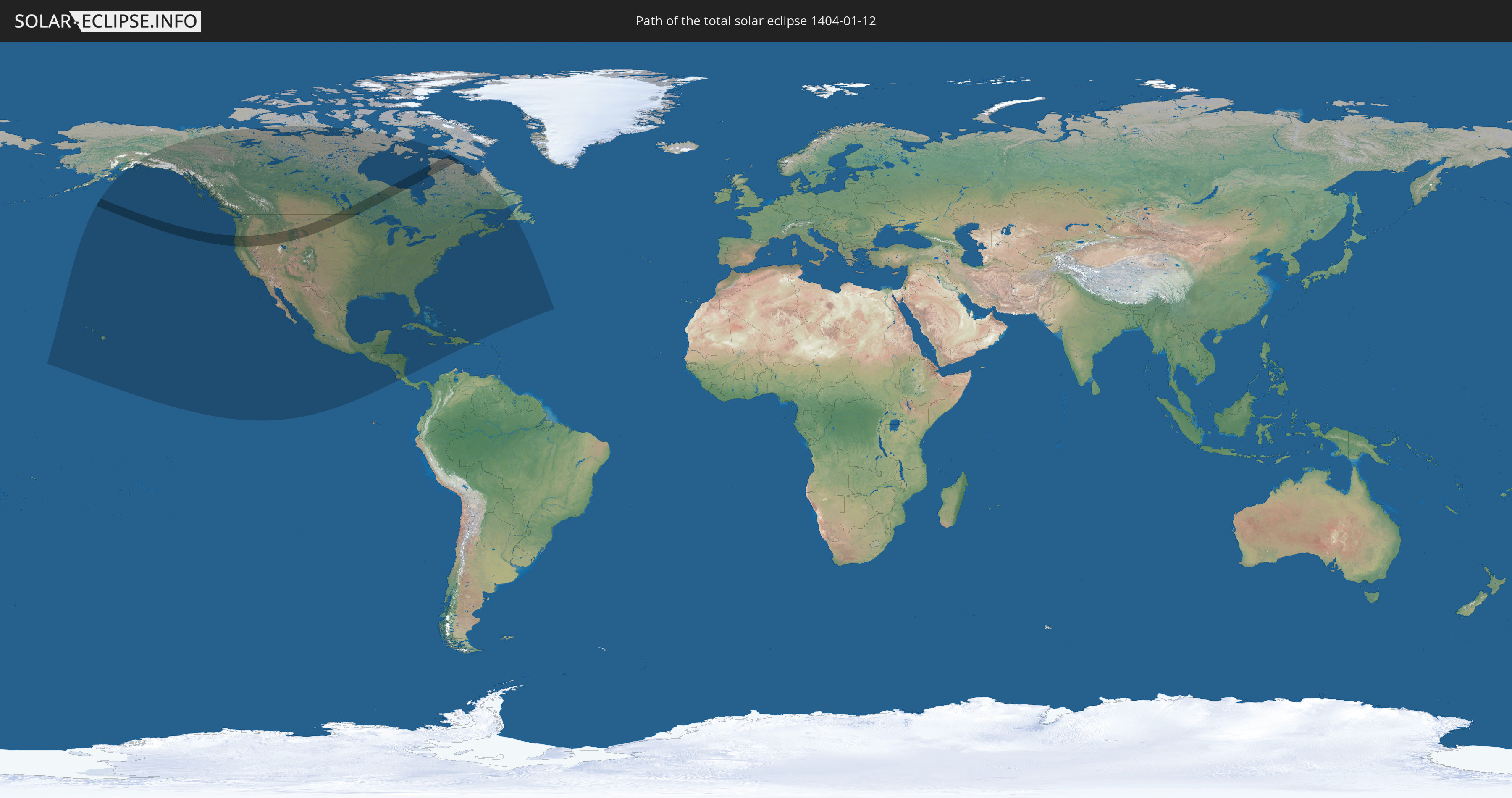
Die Sonnenfinsternis am 12.01.1404 kann man in 21 Ländern als partielle Sonnenfinsternis beobachten.
Der Finsternispfad verläuft durch 2 Länder. Nur in diesen Ländern ist sie als totale Sonnenfinsternis zu sehen.
In den folgenden Ländern ist die Sonnenfinsternis total zu sehen
 Vereinigte Staaten
 Kanada
In den folgenden Ländern ist die Sonnenfinsternis partiell zu sehen


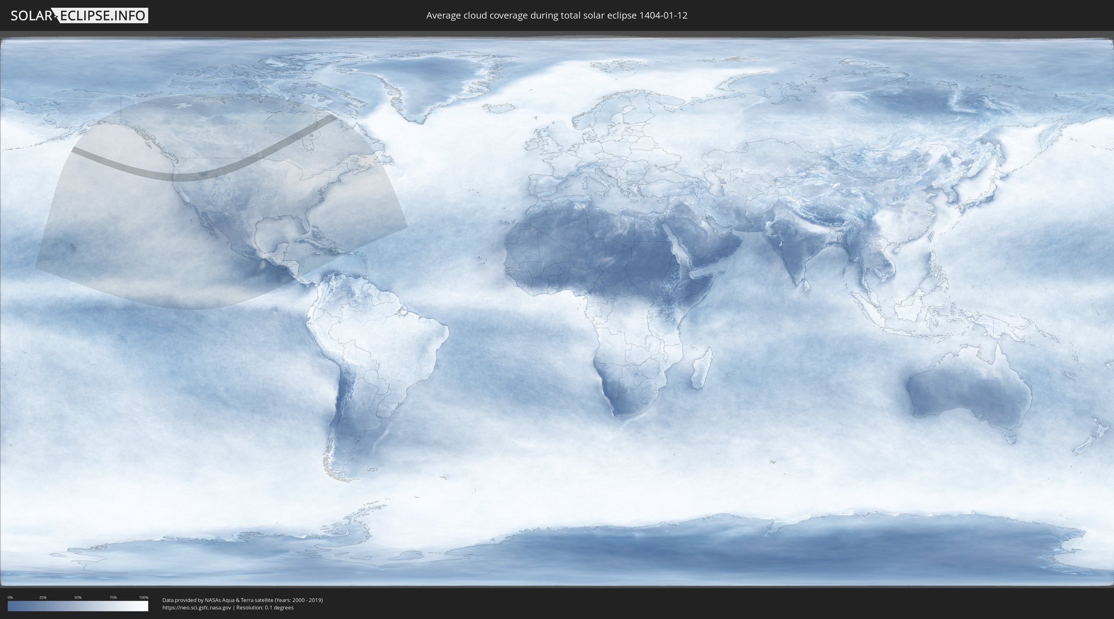
Wie wird das Wetter während der totalen Sonnenfinsternis am 12.01.1404?
Wo ist der beste Ort, um die totale Sonnenfinsternis vom 12.01.1404 zu beobachten?
Die folgenden Karten zeigen die durchschnittliche Bewölkung für den Tag, an dem die totale Sonnenfinsternis
stattfindet. Mit Hilfe der Karten lässt sich der Ort entlang des Finsternispfades eingrenzen,
der die besten Aussichen auf einen klaren wolkenfreien Himmel bietet.
Trotzdem muss man immer lokale Gegenenheiten beachten und sollte sich genau über das Wetter an seinem
gewählten Beobachtungsort informieren.
Die Daten stammen von den beiden NASA-Satelliten
AQUA und TERRA
und wurden über einen Zeitraum von 19 Jahren (2000 - 2019) gemittelt.

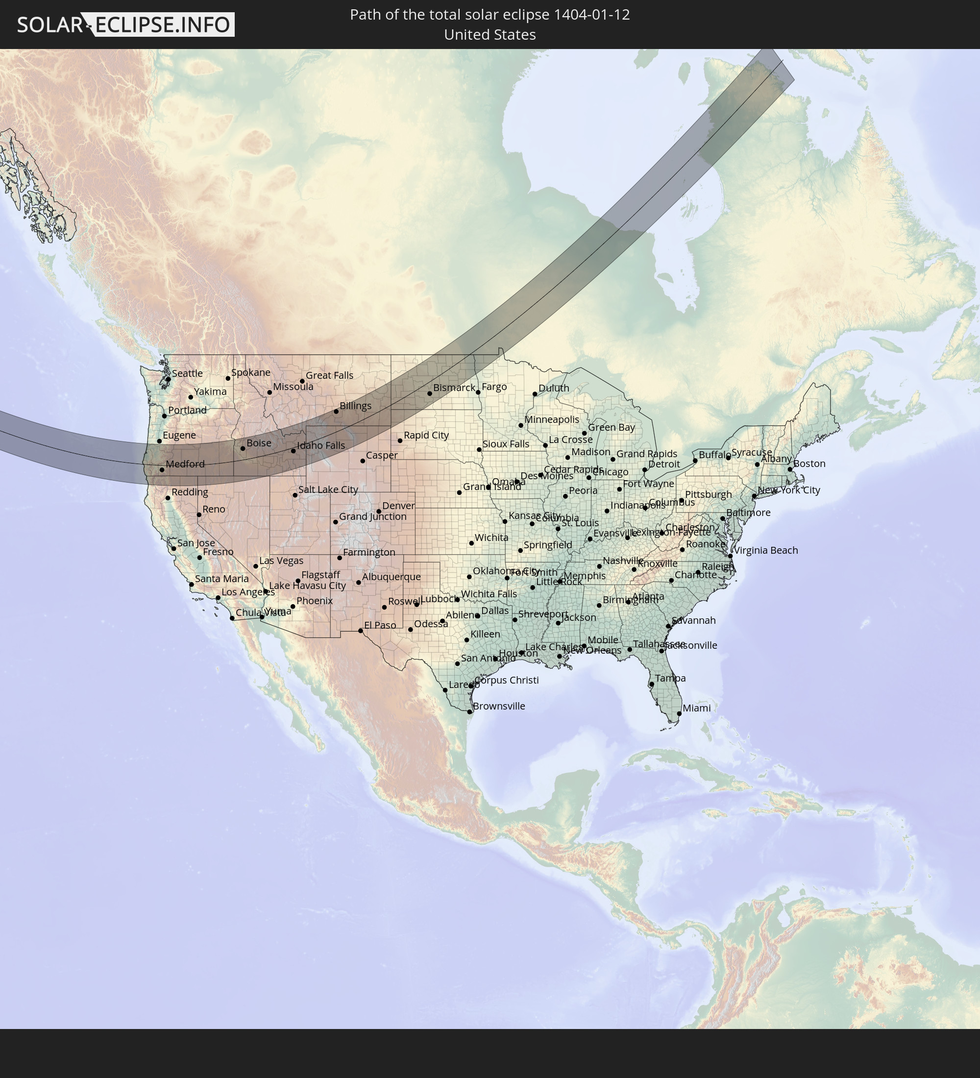
Detaillierte Länderkarten
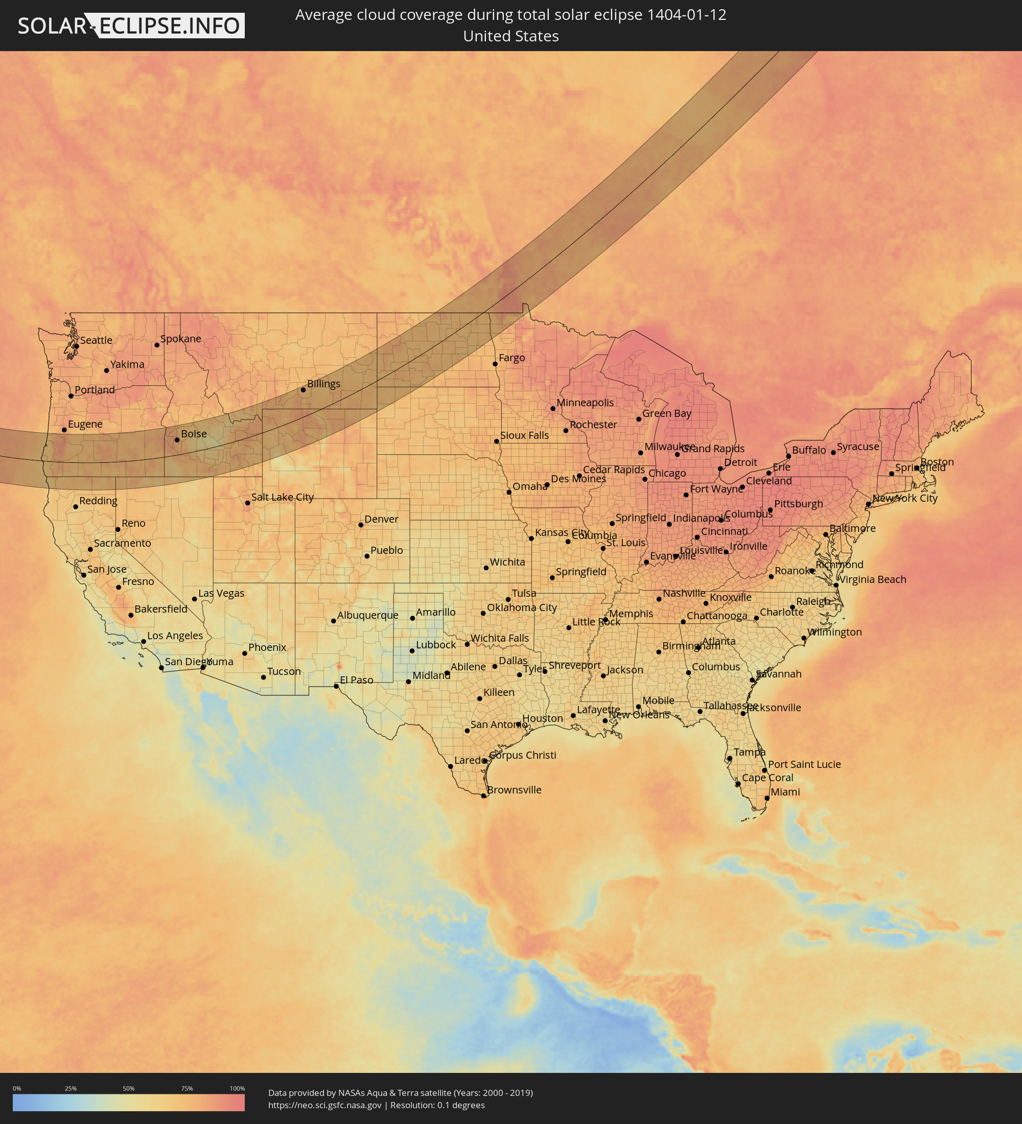 Vereinigte Staaten
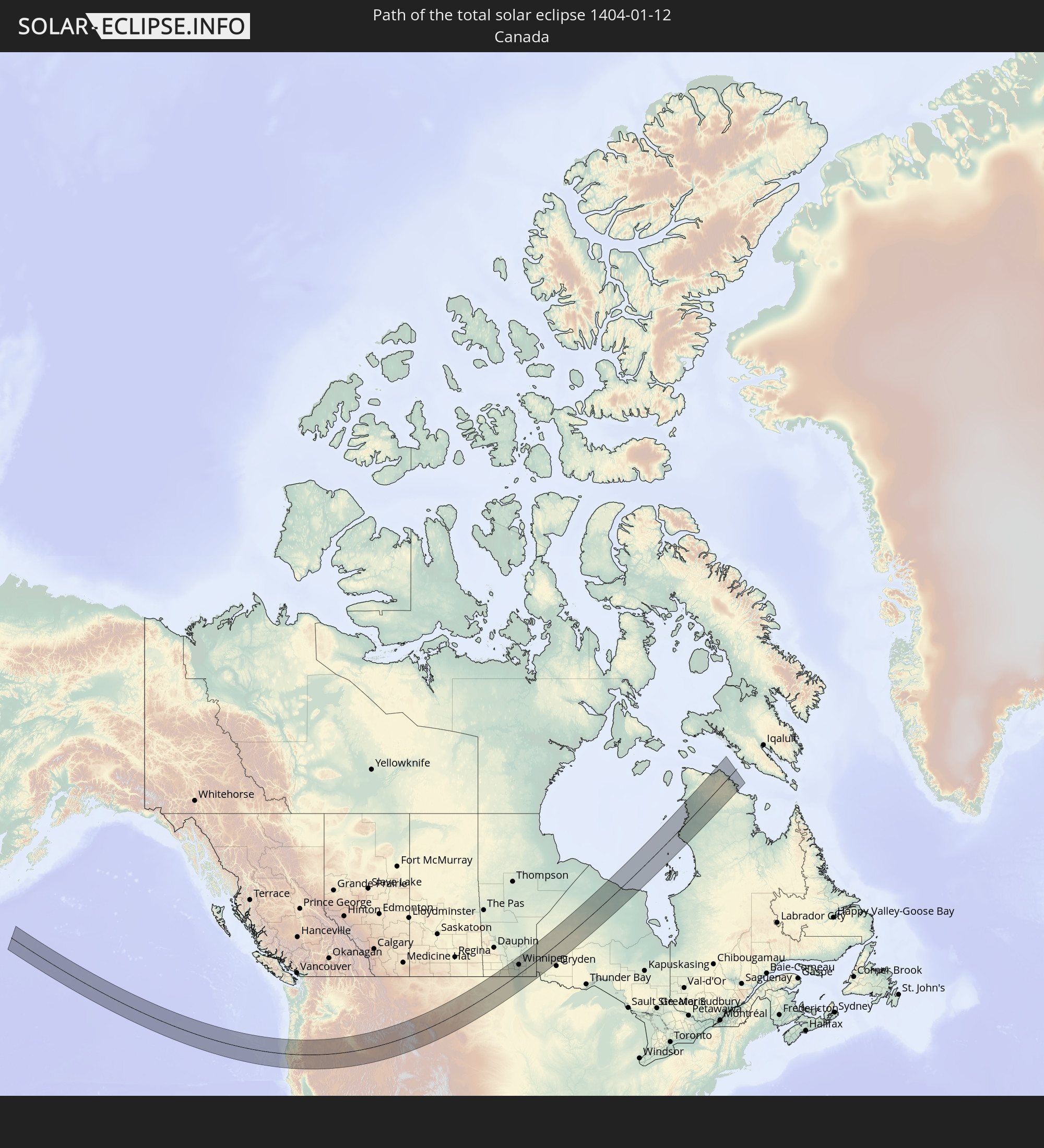
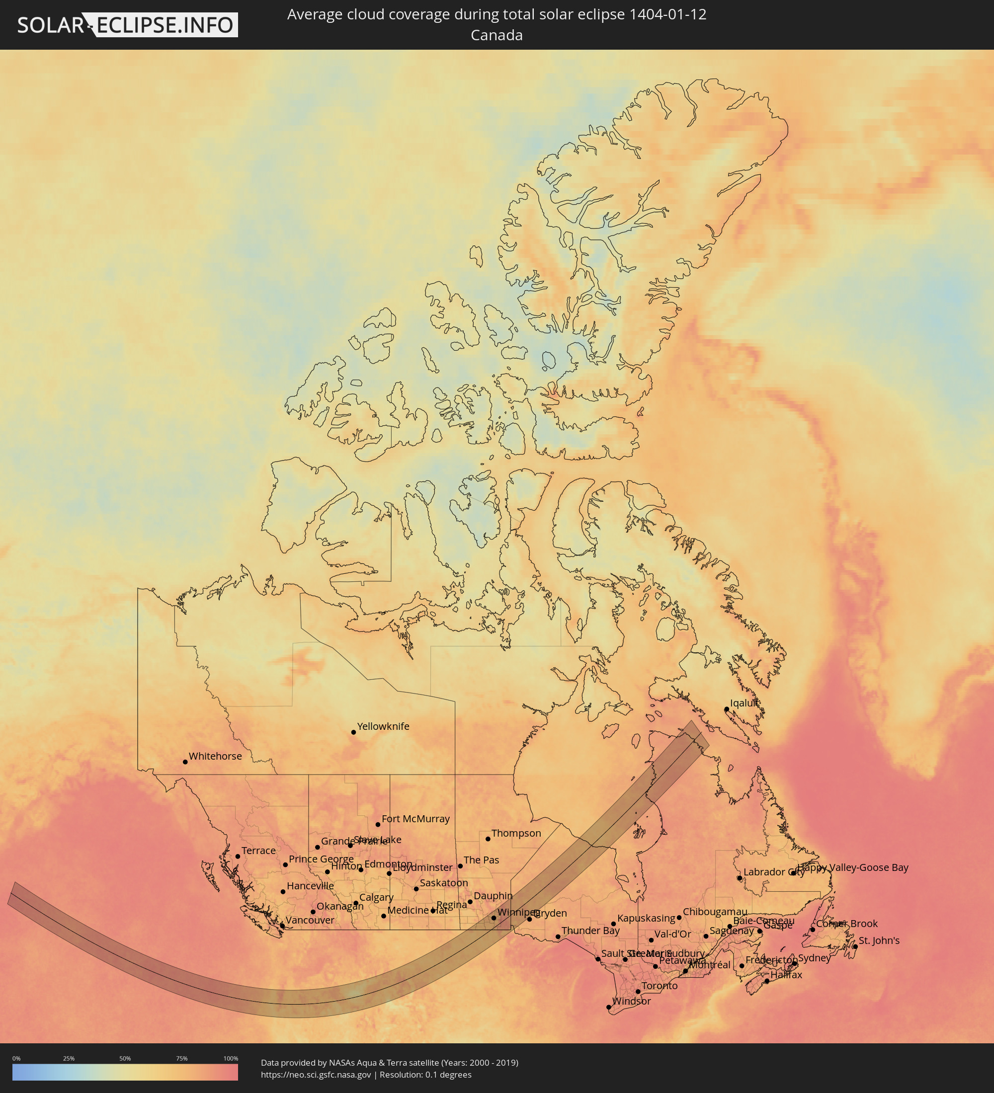 Kanada
Orte im Finsternispfad
Die nachfolgene Tabelle zeigt Städte und Orte mit mehr als 5.000 Einwohnern, die sich im Finsternispfad befinden. Städte mit mehr als 100.000 Einwohnern sind dick gekennzeichnet. Mit einem Klick auf den Ort öffnet sich eine Detailkarte die die Lage des jeweiligen Ortes zusammen mit dem Verlauf der zentralen Finsternis präsentiert.
| Ort | Typ | Dauer der Verfinsterung | Ortszeit bei maximaler Verfinsterung | Entfernung zur Zentrallinie | Ø Bewölkung |
 Brookings, Oregon
|
total | - | 10:56:03 UTC-08:00 | 72 km | 67% |
|
North Bend, Oregon
|
total | - | 10:57:16 UTC-08:00 | 79 km | 69% |
|
Coos Bay, Oregon
|
total | - | 10:57:15 UTC-08:00 | 74 km | 69% |
|
Crescent City, California
|
total | - | 10:55:57 UTC-08:00 | 105 km | 64% |
|
Winston, Oregon
|
total | - | 10:58:28 UTC-08:00 | 51 km | 83% |
|
Green, Oregon
|
total | - | 10:58:35 UTC-08:00 | 56 km | 85% |
|
Roseburg, Oregon
|
total | - | 10:58:40 UTC-08:00 | 62 km | 85% |
|
Grants Pass, Oregon
|
total | - | 10:58:05 UTC-08:00 | 24 km | 78% |
|
Sutherlin, Oregon
|
total | - | 10:58:52 UTC-08:00 | 81 km | 85% |
|
Roseburg North, Oregon
|
total | - | 10:58:47 UTC-08:00 | 68 km | 85% |
|
Cottage Grove, Oregon
|
total | - | 10:59:38 UTC-08:00 | 128 km | 84% |
|
Central Point, Oregon
|
total | - | 10:58:47 UTC-08:00 | 30 km | 78% |
|
Medford, Oregon
|
total | - | 10:58:49 UTC-08:00 | 35 km | 72% |
|
White City, Oregon
|
total | - | 10:58:56 UTC-08:00 | 23 km | 78% |
|
Eagle Point, Oregon
|
total | - | 10:59:04 UTC-08:00 | 19 km | 78% |
|
Talent, Oregon
|
total | - | 10:58:55 UTC-08:00 | 44 km | 69% |
|
Ashland, Oregon
|
total | - | 10:59:01 UTC-08:00 | 50 km | 71% |
|
Yreka, California
|
total | - | 10:58:48 UTC-08:00 | 100 km | 74% |
|
Klamath Falls, Oregon
|
total | - | 11:00:45 UTC-08:00 | 45 km | 78% |
|
Altamont, Oregon
|
total | - | 11:00:49 UTC-08:00 | 47 km | 78% |
|
Ontario, Oregon
|
total | - | 12:10:53 UTC-07:00 | 125 km | 81% |
|
Payette, Idaho
|
total | - | 12:10:58 UTC-07:00 | 130 km | 81% |
|
Caldwell, Idaho
|
total | - | 12:11:12 UTC-07:00 | 82 km | 81% |
|
Middleton, Idaho
|
total | - | 12:11:21 UTC-07:00 | 85 km | 81% |
|
Nampa, Idaho
|
total | - | 12:11:22 UTC-07:00 | 66 km | 81% |
|
Emmett, Idaho
|
total | - | 12:11:40 UTC-07:00 | 102 km | 80% |
|
Star, Idaho
|
total | - | 12:11:35 UTC-07:00 | 82 km | 80% |
|
Kuna, Idaho
|
total | - | 12:11:37 UTC-07:00 | 59 km | 80% |
|
Meridian, Idaho
|
total | - | 12:11:44 UTC-07:00 | 72 km | 80% |
|
Eagle, Idaho
|
total | - | 12:11:51 UTC-07:00 | 81 km | 79% |
|
Garden City, Idaho
|
total | - | 12:12:02 UTC-07:00 | 71 km | 78% |
|
Boise, Idaho
|
total | - | 12:12:05 UTC-07:00 | 69 km | 78% |
|
Mountain Home, Idaho
|
total | - | 12:12:49 UTC-07:00 | 9 km | 77% |
|
Jerome, Idaho
|
total | - | 12:14:52 UTC-07:00 | 55 km | 75% |
|
Twin Falls, Idaho
|
total | - | 12:14:54 UTC-07:00 | 74 km | 77% |
|
Hailey, Idaho
|
total | - | 12:15:37 UTC-07:00 | 28 km | 56% |
|
Burley, Idaho
|
total | - | 12:16:11 UTC-07:00 | 89 km | 77% |
|
Rupert, Idaho
|
total | - | 12:16:27 UTC-07:00 | 82 km | 74% |
|
Chubbuck, Idaho
|
total | - | 12:18:55 UTC-07:00 | 75 km | 80% |
|
Pocatello, Idaho
|
total | - | 12:18:56 UTC-07:00 | 81 km | 81% |
|
Blackfoot, Idaho
|
total | - | 12:19:15 UTC-07:00 | 49 km | 77% |
|
Idaho Falls, Idaho
|
total | - | 12:19:57 UTC-07:00 | 27 km | 80% |
|
Ammon, Idaho
|
total | - | 12:20:05 UTC-07:00 | 28 km | 80% |
|
Rexburg, Idaho
|
total | - | 12:20:32 UTC-07:00 | 5 km | 79% |
|
Jackson, Wyoming
|
total | - | 12:22:23 UTC-07:00 | 57 km | 76% |
|
Cody, Wyoming
|
total | - | 12:25:52 UTC-07:00 | 4 km | 78% |
|
Laurel, Montana
|
total | - | 12:26:38 UTC-07:00 | 112 km | 76% |
|
Powell, Wyoming
|
total | - | 12:26:28 UTC-07:00 | 18 km | 86% |
|
Billings, Montana
|
total | - | 12:27:08 UTC-07:00 | 115 km | 74% |
|
Lockwood, Montana
|
total | - | 12:27:18 UTC-07:00 | 116 km | 72% |
|
Worland, Wyoming
|
total | - | 12:27:49 UTC-07:00 | 82 km | 71% |
|
Sheridan, Wyoming
|
total | - | 12:29:47 UTC-07:00 | 35 km | 78% |
|
Miles City, Montana
|
total | - | 12:31:57 UTC-07:00 | 87 km | 70% |
|
Dickinson, North Dakota
|
total | - | 12:37:12 UTC-07:00 | 18 km | 75% |
|
Minot Air Force Base, North Dakota
|
total | - | 13:39:25 UTC-06:00 | 105 km | 76% |
|
Minot, North Dakota
|
total | - | 13:39:30 UTC-06:00 | 86 km | 75% |
|
Mandan, North Dakota
|
total | - | 13:40:23 UTC-06:00 | 62 km | 76% |
|
Bismarck, North Dakota
|
total | - | 13:40:34 UTC-06:00 | 68 km | 76% |
|
Devils Lake, North Dakota
|
total | - | 13:43:24 UTC-06:00 | 26 km | 73% |
 Portage la Prairie, Manitoba
|
total | - | 13:43:47 UTC-06:00 | 119 km | 77% |
|
Morden, Manitoba
|
total | - | 13:44:18 UTC-06:00 | 40 km | 76% |
|
Winkler, Manitoba
|
total | - | 13:44:32 UTC-06:00 | 33 km | 75% |
|
Winnipeg, Manitoba
|
total | - | 13:45:30 UTC-06:00 | 62 km | 80% |
|
Selkirk, Manitoba
|
total | - | 13:45:48 UTC-06:00 | 73 km | 79% |
|
Steinbach, Manitoba
|
total | - | 13:46:18 UTC-06:00 | 10 km | 81% |