Totale Sonnenfinsternis vom 21.11.1481
| Wochentag: | Montag |
| Maximale Dauer der Verfinsterung: | 03m53s |
| Maximale Breite des Finsternispfades: | 165 km |
| Saroszyklus: | 124 |
| Bedeckungsgrad: | 100% |
| Magnitude: | 1.0479 |
| Gamma: | -0.2617 |
Wo kann man die Sonnenfinsternis vom 21.11.1481 sehen?
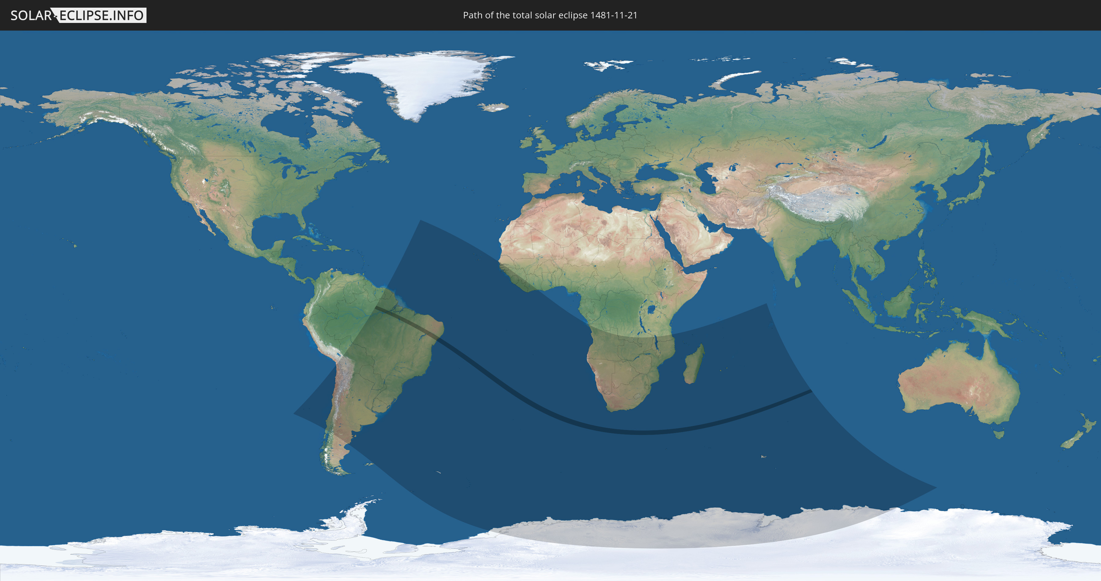
Die Sonnenfinsternis am 21.11.1481 kann man in 42 Ländern als partielle Sonnenfinsternis beobachten.
Der Finsternispfad verläuft durch ein Land. Nur in diesem Land ist sie als totale Sonnenfinsternis zu sehen.
In den folgenden Ländern ist die Sonnenfinsternis total zu sehen
 Brasilien
In den folgenden Ländern ist die Sonnenfinsternis partiell zu sehen
 Antarktika
 Chile
Chile
 Brasilien
 Argentinien
 Bolivien
 Paraguay
 Falklandinseln
 Uruguay
 Suriname
 Französisch-Guayana
 Südgeorgien und die Südlichen Sandwichinseln
 Kap Verde
 Senegal
 Gambia
 Guinea-Bissau
 Guinea
 St. Helena
 Sierra Leone
 Liberia
 Elfenbeinküste
 Bouvetinsel
 Angola
 Namibia
 Demokratische Republik Kongo
 Südafrika
 Botswana
 Sambia
 Simbabwe
 Lesotho
 Tansania
 Mosambik
 Swasiland
 Malawi
 Französische Süd- und Antarktisgebiete
 Madagaskar
 Komoren
 Mayotte
 Seychellen
 Réunion
 Mauritius
 Britisches Territorium im Indischen Ozean
 Heard und McDonaldinseln
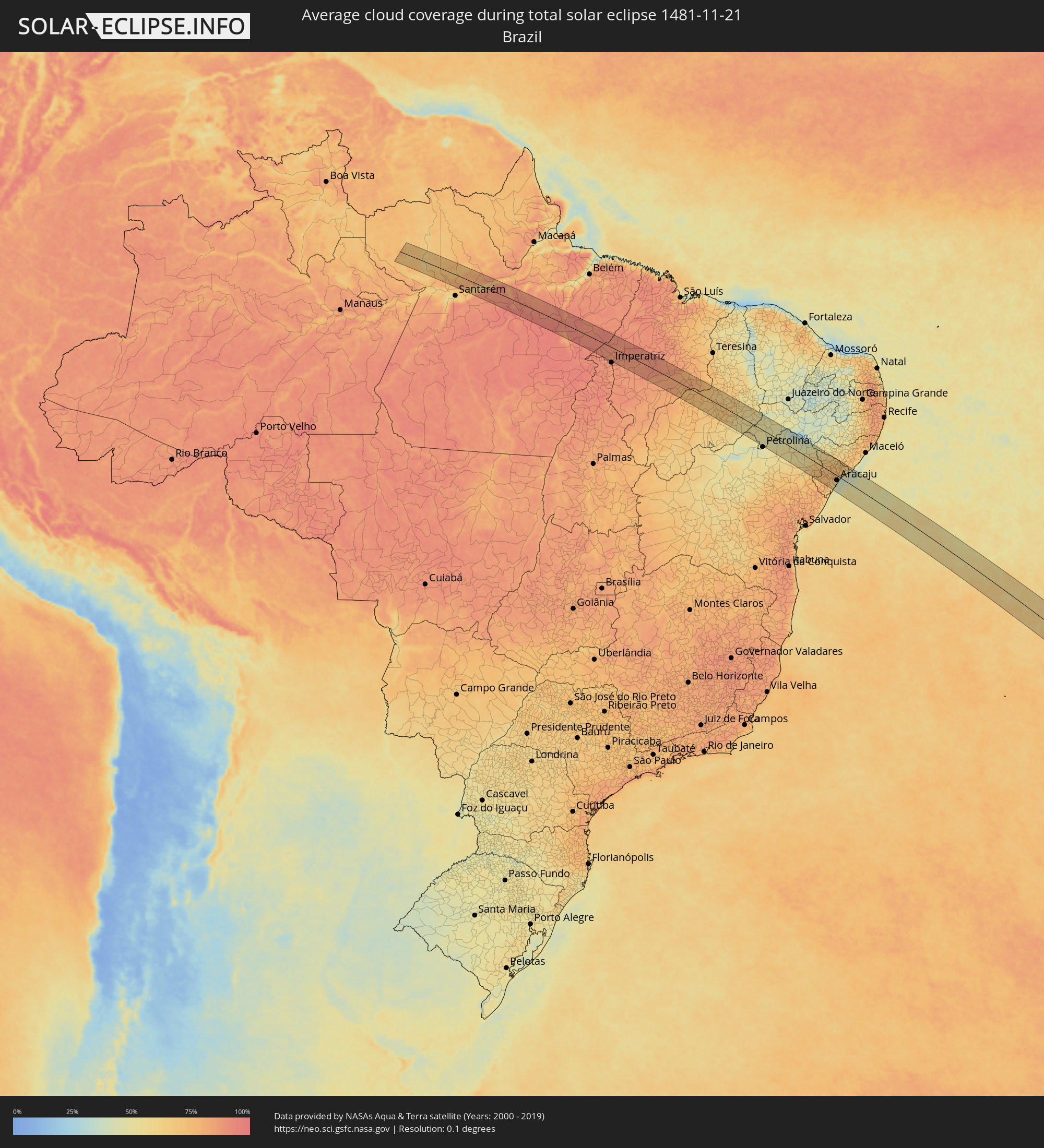
Wie wird das Wetter während der totalen Sonnenfinsternis am 21.11.1481?
Wo ist der beste Ort, um die totale Sonnenfinsternis vom 21.11.1481 zu beobachten?
Die folgenden Karten zeigen die durchschnittliche Bewölkung für den Tag, an dem die totale Sonnenfinsternis
stattfindet. Mit Hilfe der Karten lässt sich der Ort entlang des Finsternispfades eingrenzen,
der die besten Aussichen auf einen klaren wolkenfreien Himmel bietet.
Trotzdem muss man immer lokale Gegenenheiten beachten und sollte sich genau über das Wetter an seinem
gewählten Beobachtungsort informieren.
Die Daten stammen von den beiden NASA-Satelliten
AQUA und TERRA
und wurden über einen Zeitraum von 19 Jahren (2000 - 2019) gemittelt.


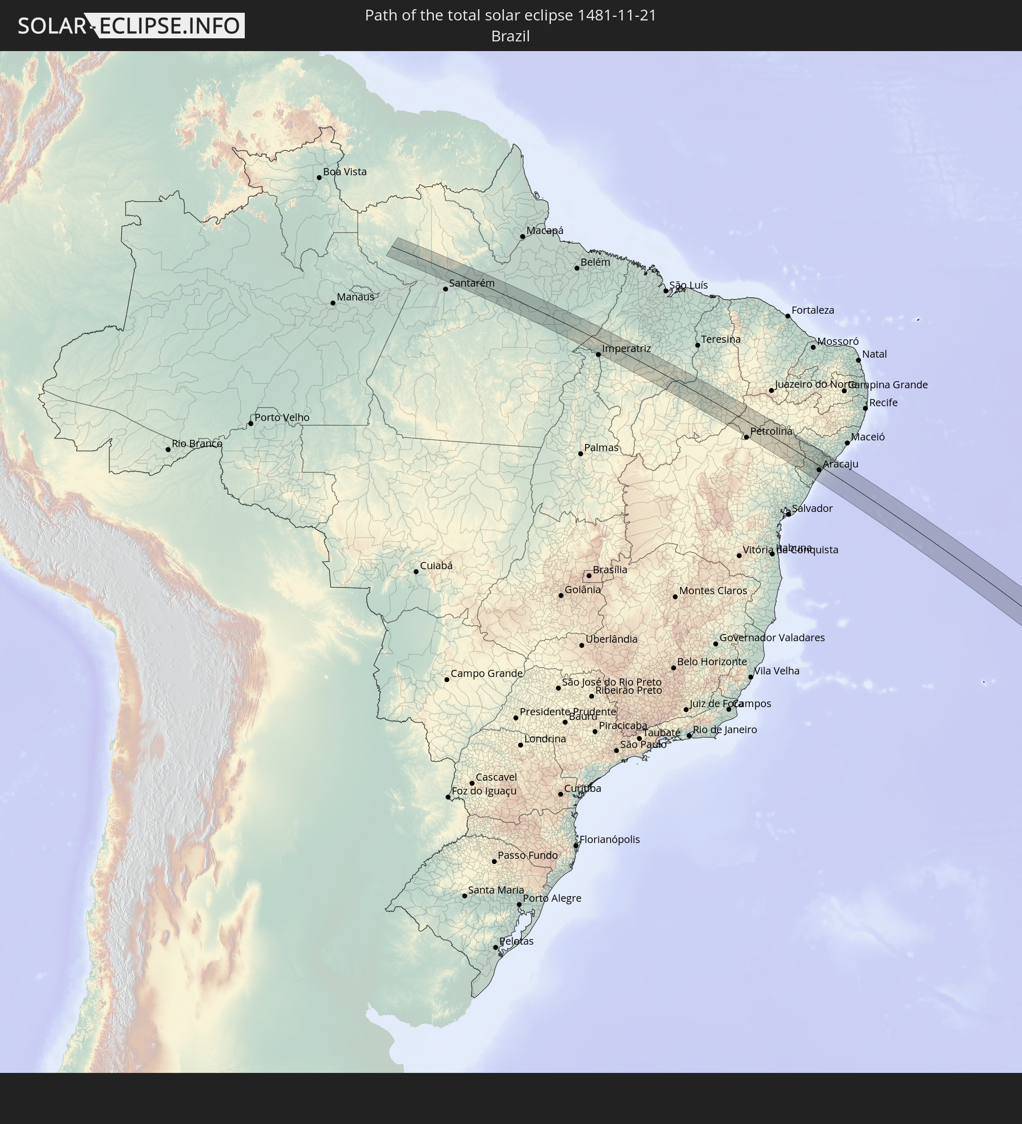
Detaillierte Länderkarten
 Brasilien
Orte im Finsternispfad
Die nachfolgene Tabelle zeigt Städte und Orte mit mehr als 5.000 Einwohnern, die sich im Finsternispfad befinden. Städte mit mehr als 100.000 Einwohnern sind dick gekennzeichnet. Mit einem Klick auf den Ort öffnet sich eine Detailkarte die die Lage des jeweiligen Ortes zusammen mit dem Verlauf der zentralen Finsternis präsentiert.
| Ort | Typ | Dauer der Verfinsterung | Ortszeit bei maximaler Verfinsterung | Entfernung zur Zentrallinie | Ø Bewölkung |
|
Alenquer, Pará
|
total | - | 06:24:47 UTC-03:13 | 50 km | 76% |
|
Monte Alegre, Pará
|
total | - | 06:24:43 UTC-03:13 | 27 km | 65% |
|
Prainha, Pará
|
total | - | 06:24:28 UTC-03:13 | 20 km | 62% |
|
Senador José Porfírio, Pará
|
total | - | 06:24:50 UTC-03:13 | 9 km | 86% |
|
Tucuruí, Pará
|
total | - | 06:25:32 UTC-03:13 | 2 km | 90% |
|
Amarante do Maranhão, Maranhão
|
total | - | 07:06:57 UTC-02:34 | 36 km | 86% |
|
Grajaú, Maranhão
|
total | - | 07:07:12 UTC-02:34 | 30 km | 89% |
|
Barra do Corda, Maranhão
|
total | - | 07:06:58 UTC-02:34 | 48 km | 87% |
|
Mirador, Maranhão
|
total | - | 07:07:51 UTC-02:34 | 8 km | 78% |
|
Colinas, Maranhão
|
total | - | 07:07:32 UTC-02:34 | 48 km | 78% |
|
Raposa, Maranhão
|
total | - | 07:08:00 UTC-02:34 | 3 km | 80% |
|
Pastos Bons, Maranhão
|
total | - | 07:08:06 UTC-02:34 | 1 km | 79% |
|
Paraibano, Maranhão
|
total | - | 07:07:57 UTC-02:34 | 22 km | 79% |
|
Passagem Franca, Maranhão
|
total | - | 07:07:44 UTC-02:34 | 58 km | 81% |
|
São João dos Patos, Maranhão
|
total | - | 07:08:03 UTC-02:34 | 31 km | 78% |
|
Itaueira, Piauí
|
total | - | 07:09:13 UTC-02:34 | 40 km | 69% |
|
Floriano, Piauí
|
total | - | 07:08:24 UTC-02:34 | 41 km | 71% |
|
Oeiras, Piauí
|
total | - | 07:08:47 UTC-02:34 | 64 km | 63% |
|
Simplício Mendes, Piauí
|
total | - | 07:09:39 UTC-02:34 | 4 km | 64% |
|
Curaçá, Bahia
|
total | - | 07:11:17 UTC-02:34 | 2 km | 46% |
|
Santa Maria da Boa Vista, Pernambuco
|
total | - | 07:25:31 UTC-02:19 | 21 km | 46% |
|
Uauá, Bahia
|
total | - | 07:12:19 UTC-02:34 | 58 km | 54% |
|
Jeremoabo, Bahia
|
total | - | 07:12:53 UTC-02:34 | 23 km | 59% |
|
Cícero Dantas, Bahia
|
total | - | 07:13:30 UTC-02:34 | 67 km | 68% |
|
Paulo Afonso, Bahia
|
total | - | 07:12:13 UTC-02:34 | 56 km | 46% |
|
Poço Verde, Sergipe
|
total | - | 07:13:41 UTC-02:34 | 66 km | 70% |
|
Delmiro Gouveia, Alagoas
|
total | - | 07:12:16 UTC-02:34 | 70 km | 49% |
|
Paripiranga, Bahia
|
total | - | 07:13:46 UTC-02:34 | 45 km | 70% |
|
Simão Dias, Sergipe
|
total | - | 07:13:51 UTC-02:34 | 47 km | 73% |
|
Canindé de São Francisco, Sergipe
|
total | - | 07:12:38 UTC-02:34 | 56 km | 61% |
|
Carira, Sergipe
|
total | - | 07:13:27 UTC-02:34 | 5 km | 71% |
|
Lagarto, Sergipe
|
total | - | 07:14:07 UTC-02:34 | 54 km | 78% |
|
Monte Alegre de Sergipe, Sergipe
|
total | - | 07:13:08 UTC-02:34 | 35 km | 67% |
|
Frei Paulo, Sergipe
|
total | - | 07:13:44 UTC-02:34 | 13 km | 74% |
|
Campo do Brito, Sergipe
|
total | - | 07:13:57 UTC-02:34 | 28 km | 75% |
|
Salgado, Sergipe
|
total | - | 07:14:18 UTC-02:34 | 55 km | 72% |
|
Pão de Açúcar, Alagoas
|
total | - | 07:12:51 UTC-02:34 | 68 km | 62% |
|
Itabaiana, Sergipe
|
total | - | 07:13:55 UTC-02:34 | 19 km | 73% |
|
Nossa Senhora da Glória, Sergipe
|
total | - | 07:13:24 UTC-02:34 | 25 km | 73% |
|
Ribeirópolis, Sergipe
|
total | - | 07:13:46 UTC-02:34 | 5 km | 71% |
|
Areia Branca, Sergipe
|
total | - | 07:14:03 UTC-02:34 | 20 km | 70% |
|
Malhador, Sergipe
|
total | - | 07:13:56 UTC-02:34 | 10 km | 73% |
|
Porto da Folha, Sergipe
|
total | - | 07:13:06 UTC-02:34 | 62 km | 65% |
|
São Cristóvão, Sergipe
|
total | - | 07:14:23 UTC-02:34 | 38 km | 56% |
|
Nossa Senhora das Dores, Sergipe
|
total | - | 07:13:47 UTC-02:34 | 12 km | 74% |
|
Laranjeiras, Sergipe
|
total | - | 07:14:09 UTC-02:34 | 16 km | 63% |
|
Nossa Senhora do Socorro, Sergipe
|
total | - | 07:14:14 UTC-02:34 | 18 km | 54% |
|
Maruim, Sergipe
|
total | - | 07:14:06 UTC-02:34 | 4 km | 57% |
|
Aracaju, Sergipe
|
total | - | 07:14:19 UTC-02:34 | 20 km | 54% |
|
Santo Amaro das Brotas, Sergipe
|
total | - | 07:14:11 UTC-02:34 | 7 km | 52% |
|
Capela, Sergipe
|
total | - | 07:13:51 UTC-02:34 | 20 km | 74% |
|
Barra dos Coqueiros, Sergipe
|
total | - | 07:14:19 UTC-02:34 | 18 km | 43% |
|
Aquidabã, Sergipe
|
total | - | 07:13:36 UTC-02:34 | 42 km | 73% |
|
Japaratuba, Sergipe
|
total | - | 07:14:00 UTC-02:34 | 18 km | 57% |
|
Propriá, Sergipe
|
total | - | 07:13:36 UTC-02:34 | 60 km | 64% |
|
Porto Real do Colégio, Alagoas
|
total | - | 07:13:34 UTC-02:34 | 62 km | 64% |
|
Penedo, Alagoas
|
total | - | 07:13:47 UTC-02:34 | 67 km | 59% |
|
Neópolis, Sergipe
|
total | - | 07:13:49 UTC-02:34 | 65 km | 59% |
|
Piaçabuçu, Alagoas
|
total | - | 07:13:58 UTC-02:34 | 65 km | 47% |