Totale Sonnenfinsternis vom 20.07.1487
| Wochentag: | Mittwoch |
| Maximale Dauer der Verfinsterung: | 03m47s |
| Maximale Breite des Finsternispfades: | 446 km |
| Saroszyklus: | 108 |
| Bedeckungsgrad: | 100% |
| Magnitude: | 1.0673 |
| Gamma: | 0.8696 |
Wo kann man die Sonnenfinsternis vom 20.07.1487 sehen?
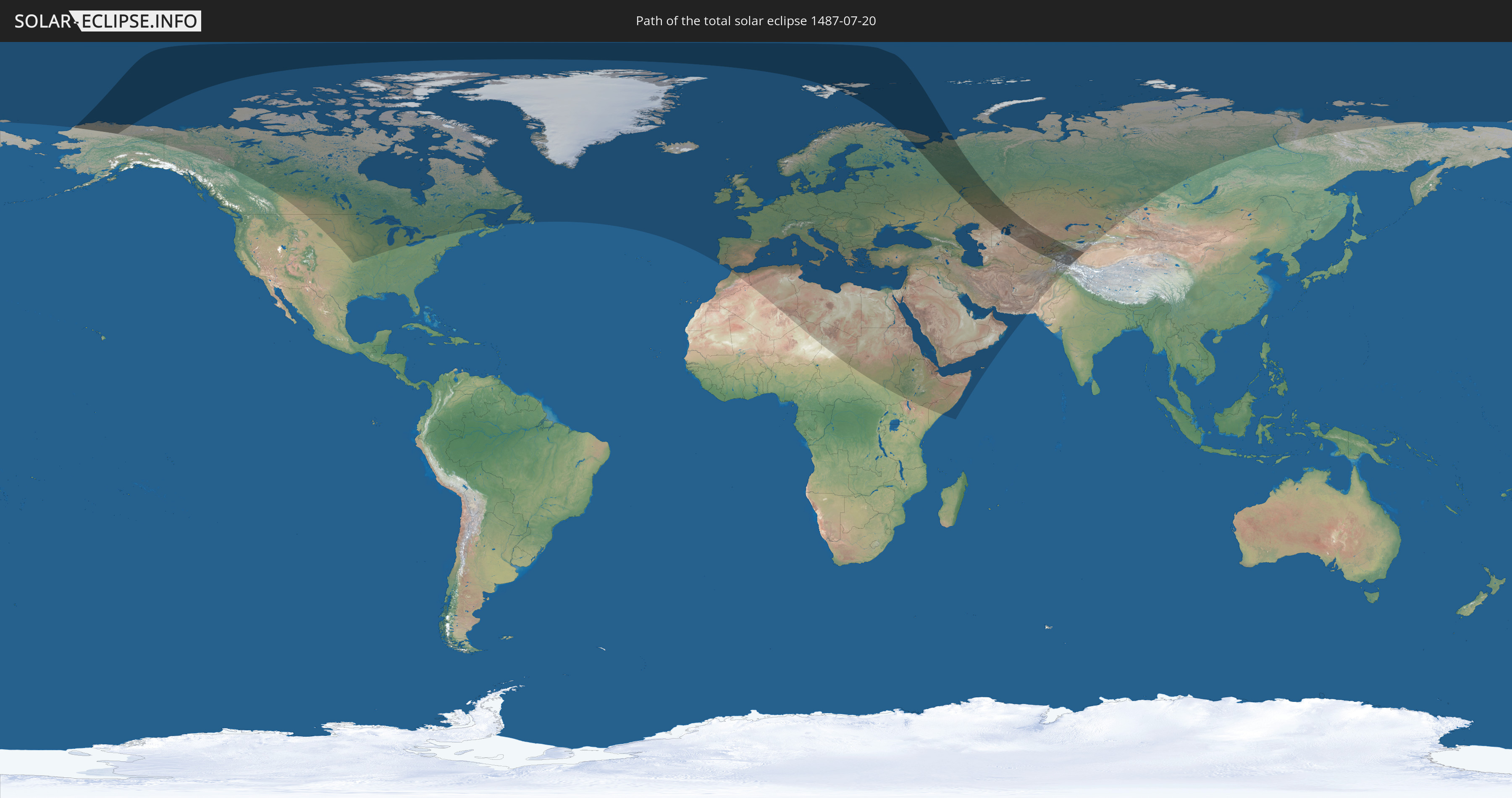
Die Sonnenfinsternis am 20.07.1487 kann man in 96 Ländern als partielle Sonnenfinsternis beobachten.
Der Finsternispfad verläuft durch 10 Länder. Nur in diesen Ländern ist sie als totale Sonnenfinsternis zu sehen.
In den folgenden Ländern ist die Sonnenfinsternis total zu sehen
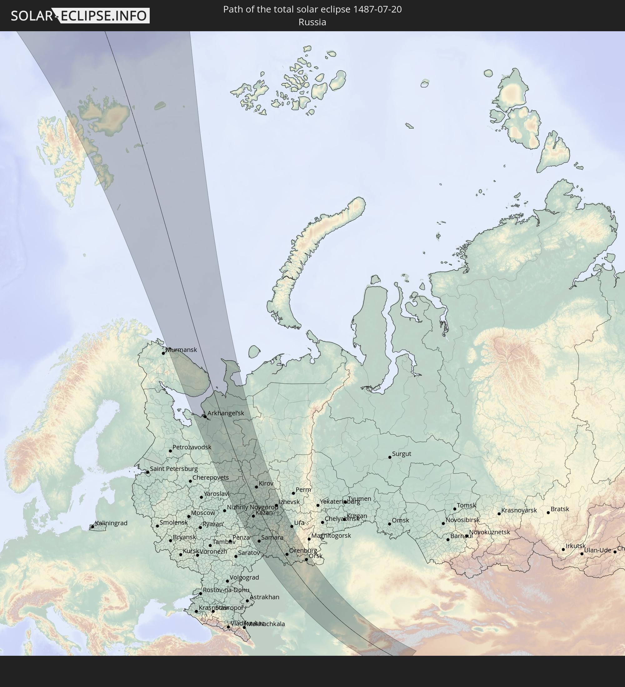 Russland
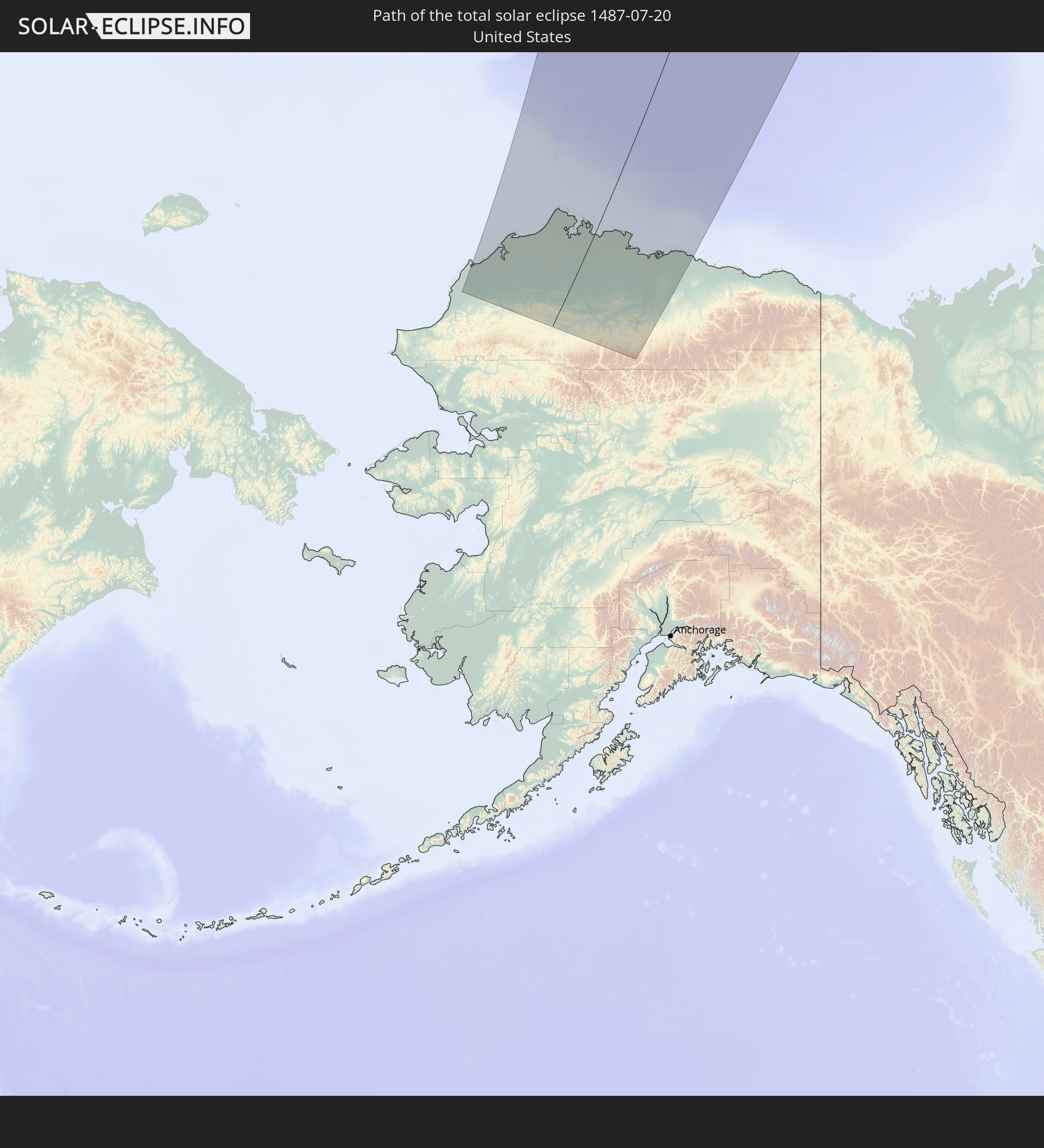 Vereinigte Staaten
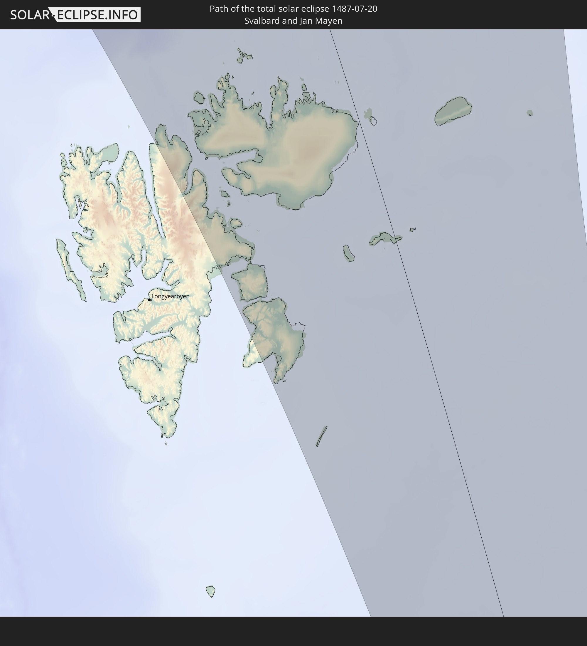 Spitzbergen
 Kasachstan
 Usbekistan
 Afghanistan
 Pakistan
 Tadschikistan
 Kirgisistan
 Volksrepublik China
In den folgenden Ländern ist die Sonnenfinsternis partiell zu sehen
 Russland
 Vereinigte Staaten
 Kanada
 Grönland
 Saint-Pierre und Miquelon
 Portugal
 Island
 Spanien
 Marokko
 Irland
 Spitzbergen
 Algerien
 Vereinigtes Königreich
 Färöer
 Gibraltar
 Frankreich
 Isle of Man
 Guernsey
 Jersey
 Niger
Niger
 Andorra
 Belgien
 Niederlande
 Norwegen
 Luxemburg
 Deutschland
 Schweiz
 Italien
 Monaco
 Tunesien
 Dänemark
 Libyen
 Liechtenstein
 Österreich
 Schweden
 Tschechien
 San Marino
 Vatikanstadt
 Slowenien
 Tschad
 Kroatien
 Polen
Polen
 Malta
Malta
 Bosnien und Herzegowina
 Ungarn
 Slowakei
 Montenegro
 Serbien
 Albanien
 Åland Islands
 Griechenland
 Rumänien
 Mazedonien
 Finnland
 Litauen
 Lettland
 Estland
 Sudan
Sudan
 Ukraine
 Bulgarien
 Weißrussland
 Ägypten
 Türkei
 Moldawien
 Republik Zypern
 Äthiopien
 Kenia
Kenia
 Staat Palästina
 Israel
 Saudi-Arabien
 Jordanien
 Libanon
 Syrien
 Eritrea
 Irak
Irak
 Georgien
 Somalia
 Dschibuti
 Jemen
Jemen
 Armenien
 Iran
Iran
 Aserbaidschan
 Kasachstan
 Kuwait
 Bahrain
 Katar
Katar
 Vereinigte Arabische Emirate
 Oman
Oman
 Turkmenistan
 Usbekistan
 Afghanistan
 Pakistan
 Tadschikistan
 Kirgisistan
 Volksrepublik China
 Mongolei
Wie wird das Wetter während der totalen Sonnenfinsternis am 20.07.1487?
Wo ist der beste Ort, um die totale Sonnenfinsternis vom 20.07.1487 zu beobachten?
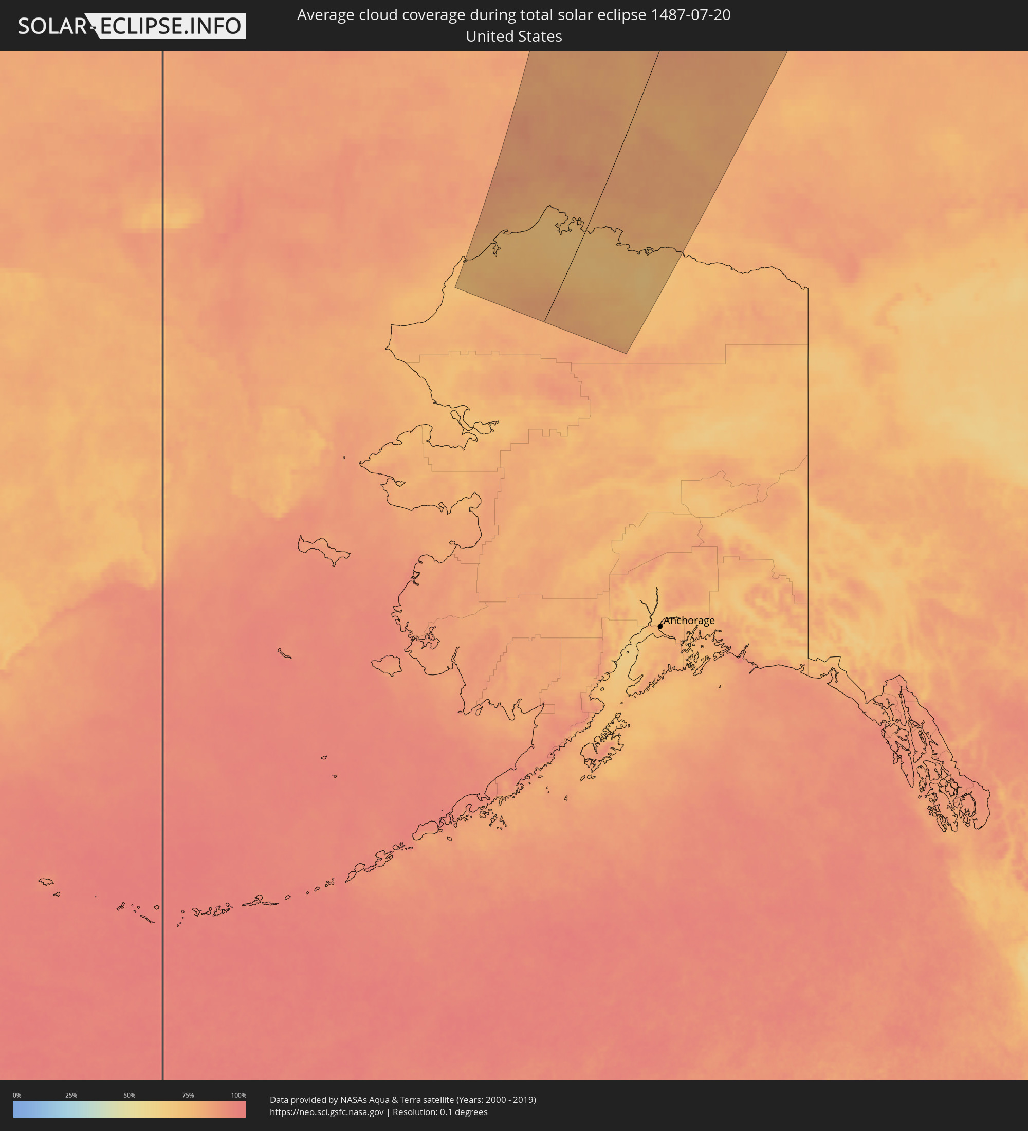
Die folgenden Karten zeigen die durchschnittliche Bewölkung für den Tag, an dem die totale Sonnenfinsternis
stattfindet. Mit Hilfe der Karten lässt sich der Ort entlang des Finsternispfades eingrenzen,
der die besten Aussichen auf einen klaren wolkenfreien Himmel bietet.
Trotzdem muss man immer lokale Gegenenheiten beachten und sollte sich genau über das Wetter an seinem
gewählten Beobachtungsort informieren.
Die Daten stammen von den beiden NASA-Satelliten
AQUA und TERRA
und wurden über einen Zeitraum von 19 Jahren (2000 - 2019) gemittelt.


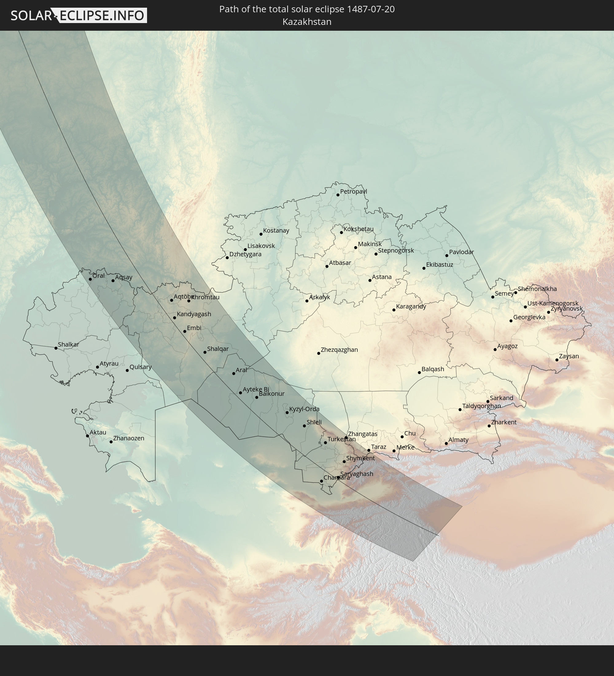
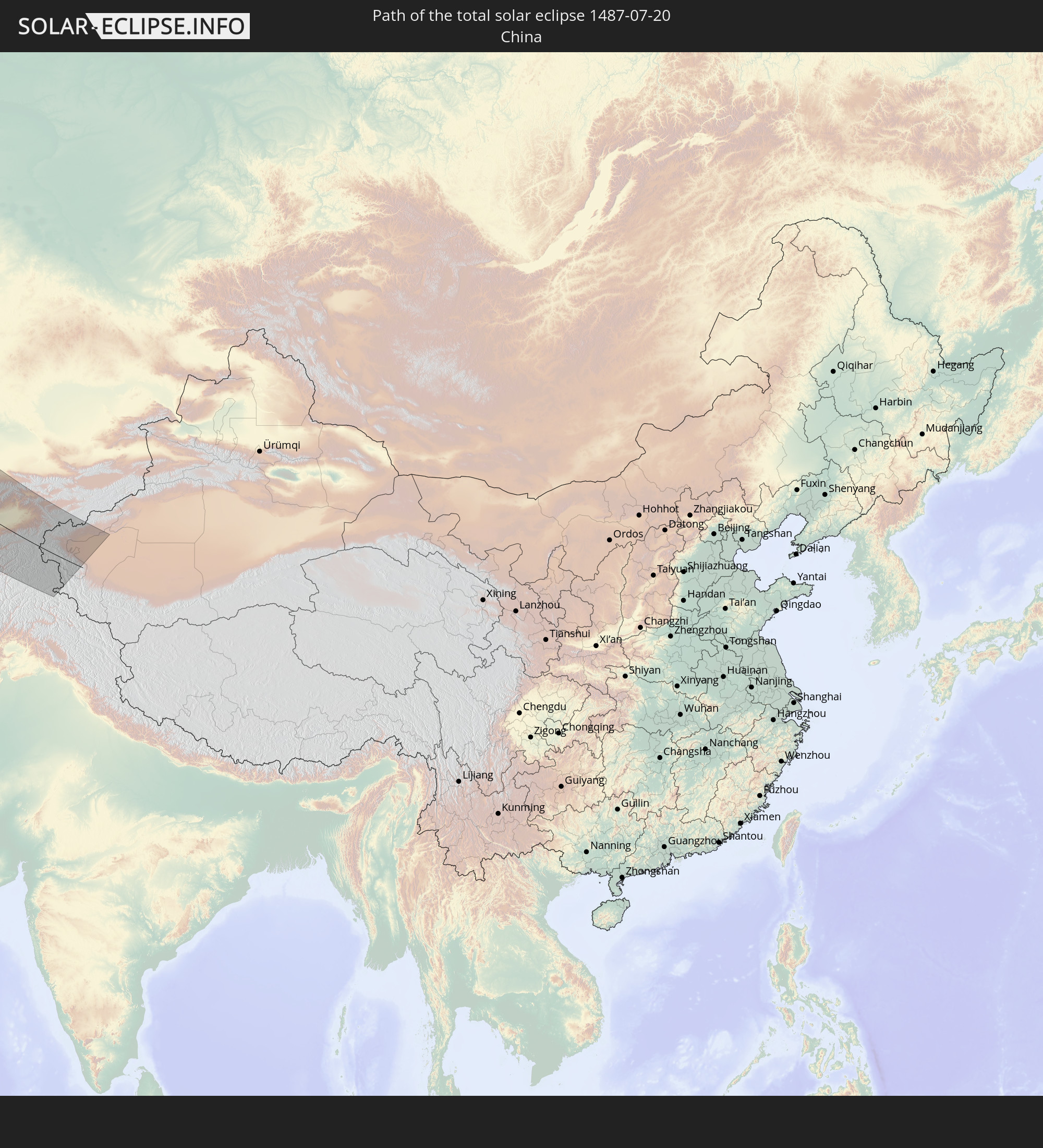
Detaillierte Länderkarten
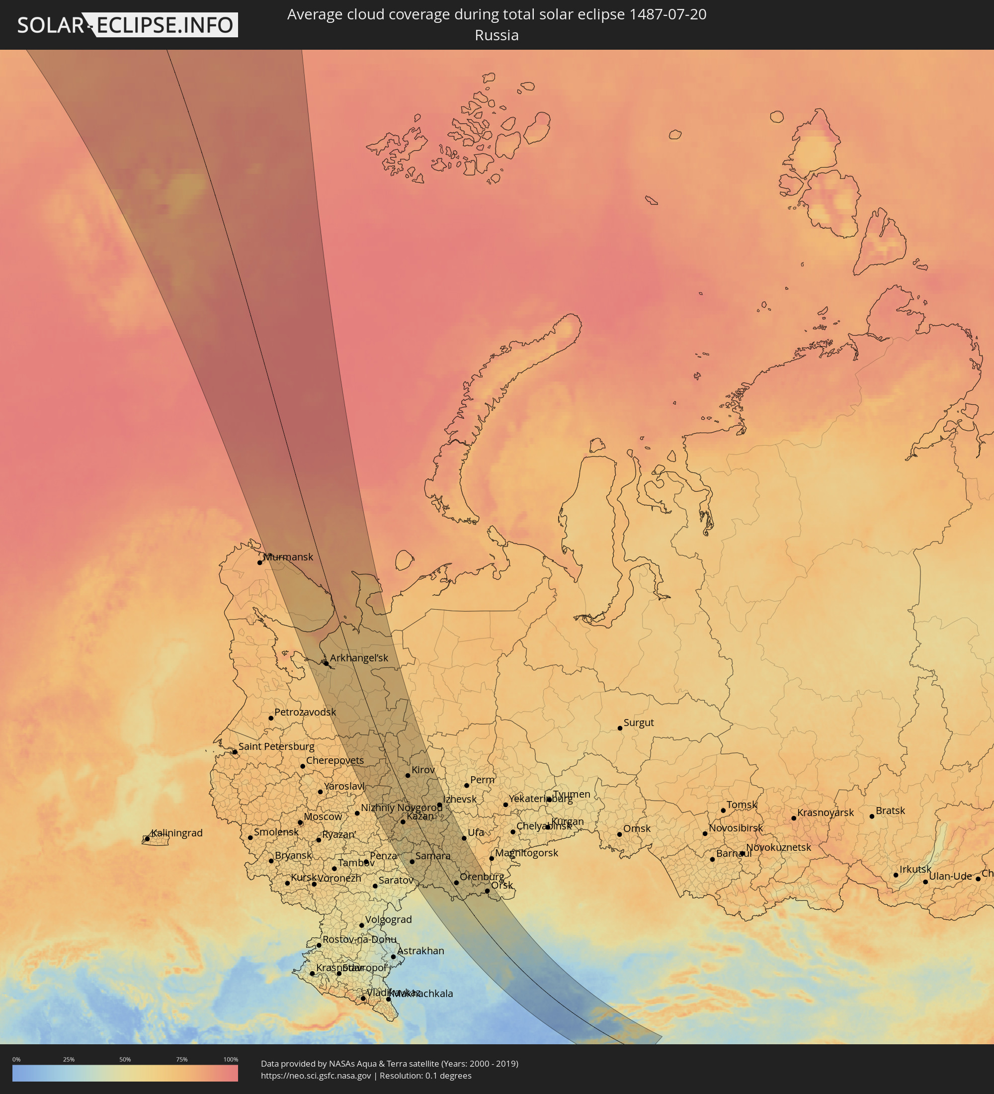 Russland
 Vereinigte Staaten
 Spitzbergen
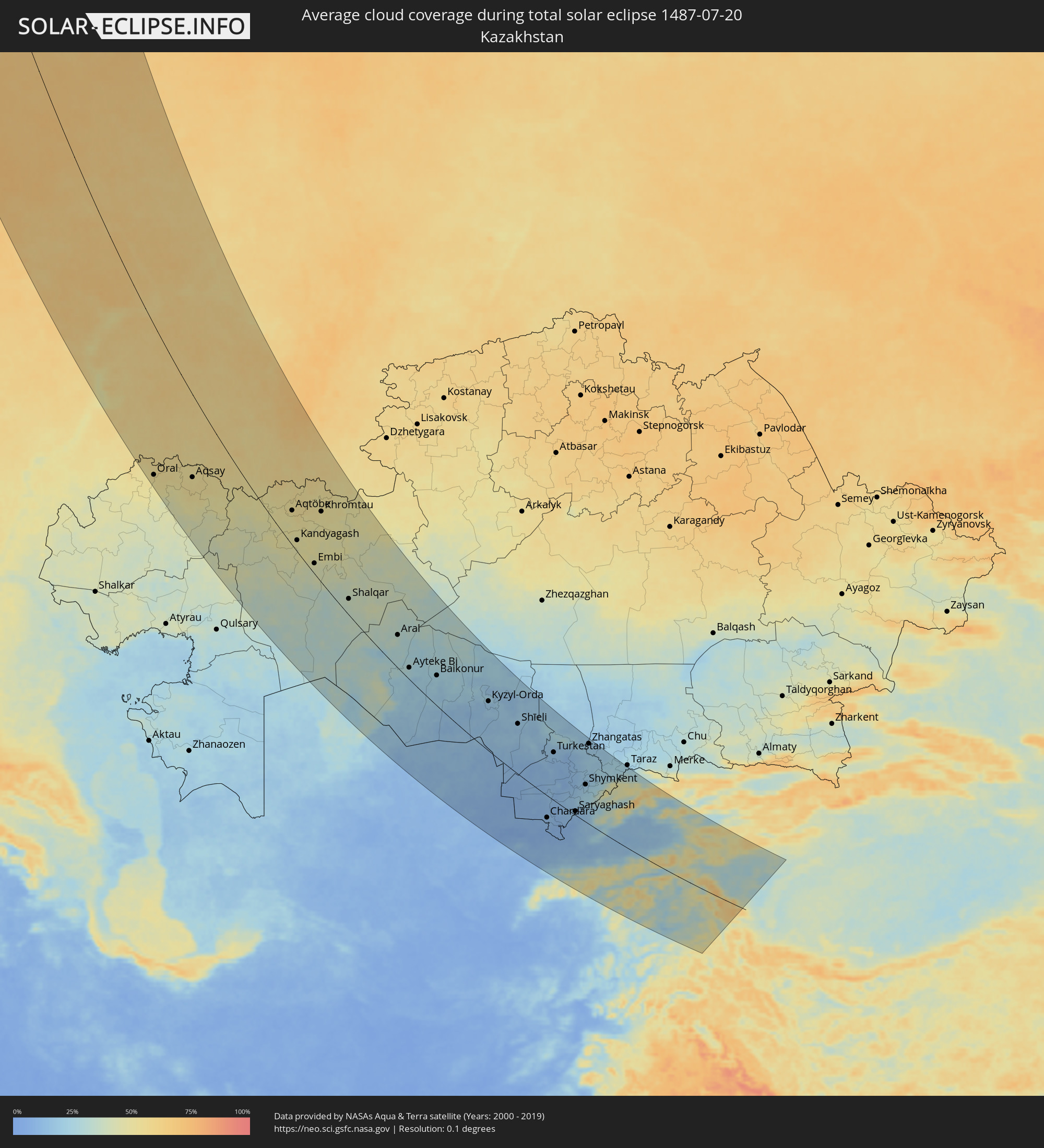 Kasachstan
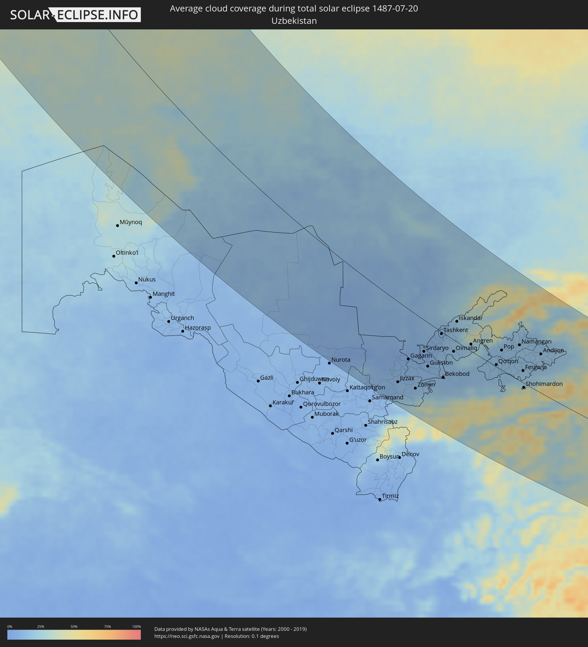 Usbekistan
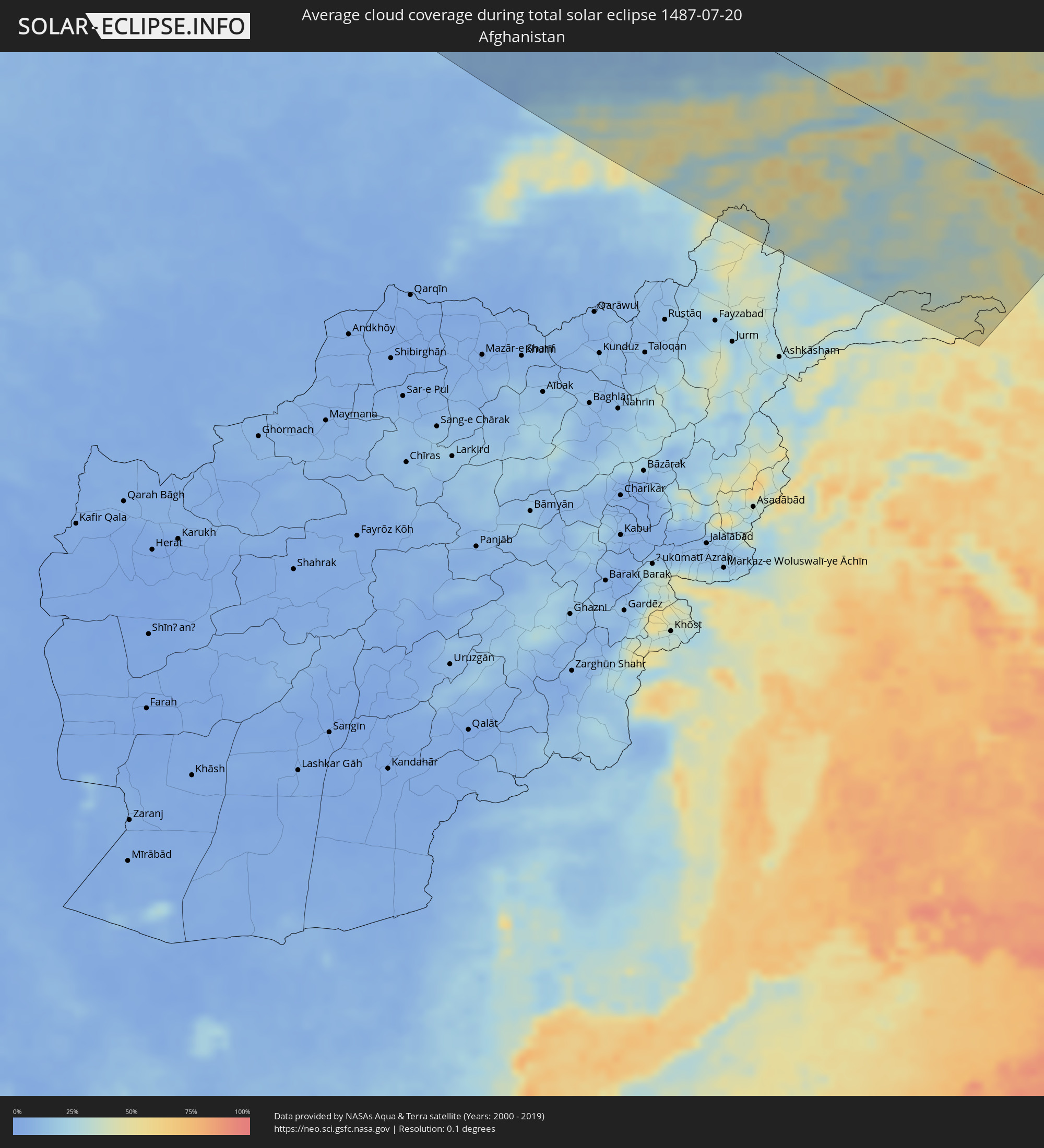 Afghanistan
 Pakistan
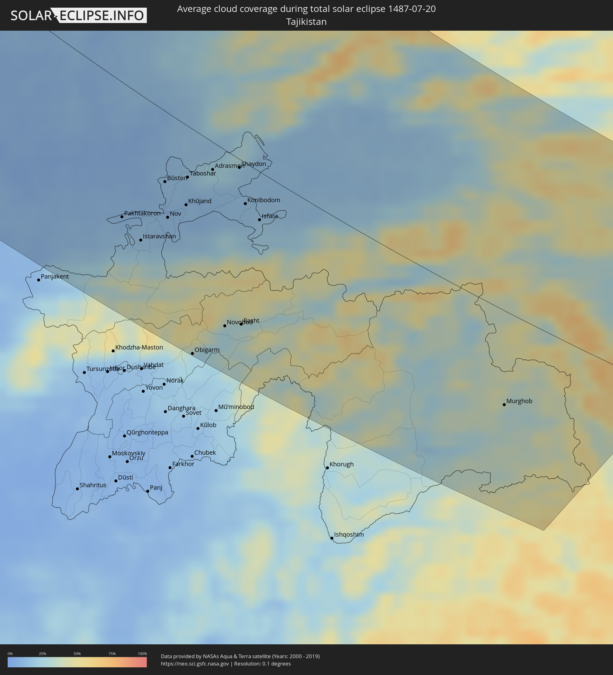 Tadschikistan
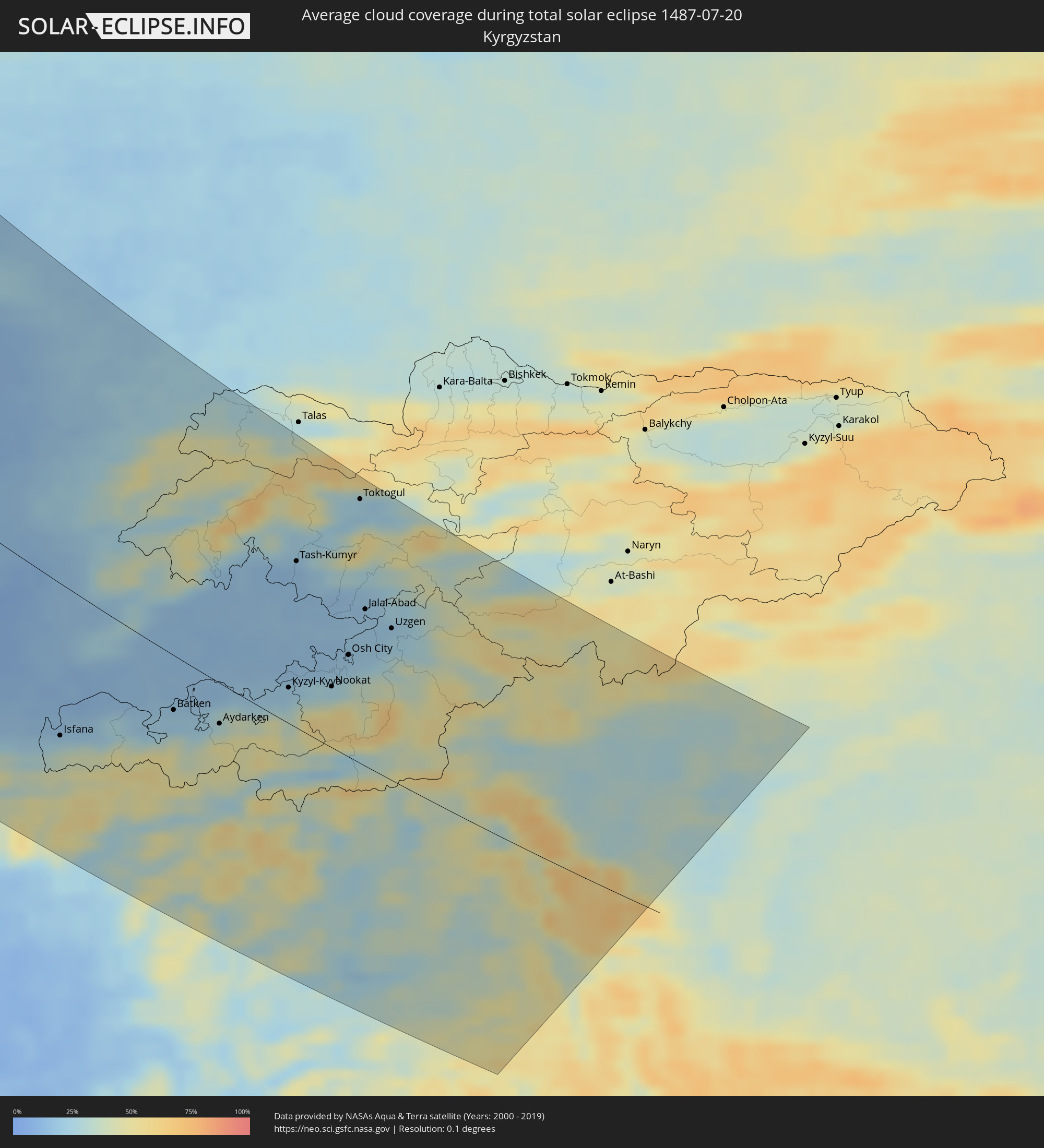 Kirgisistan
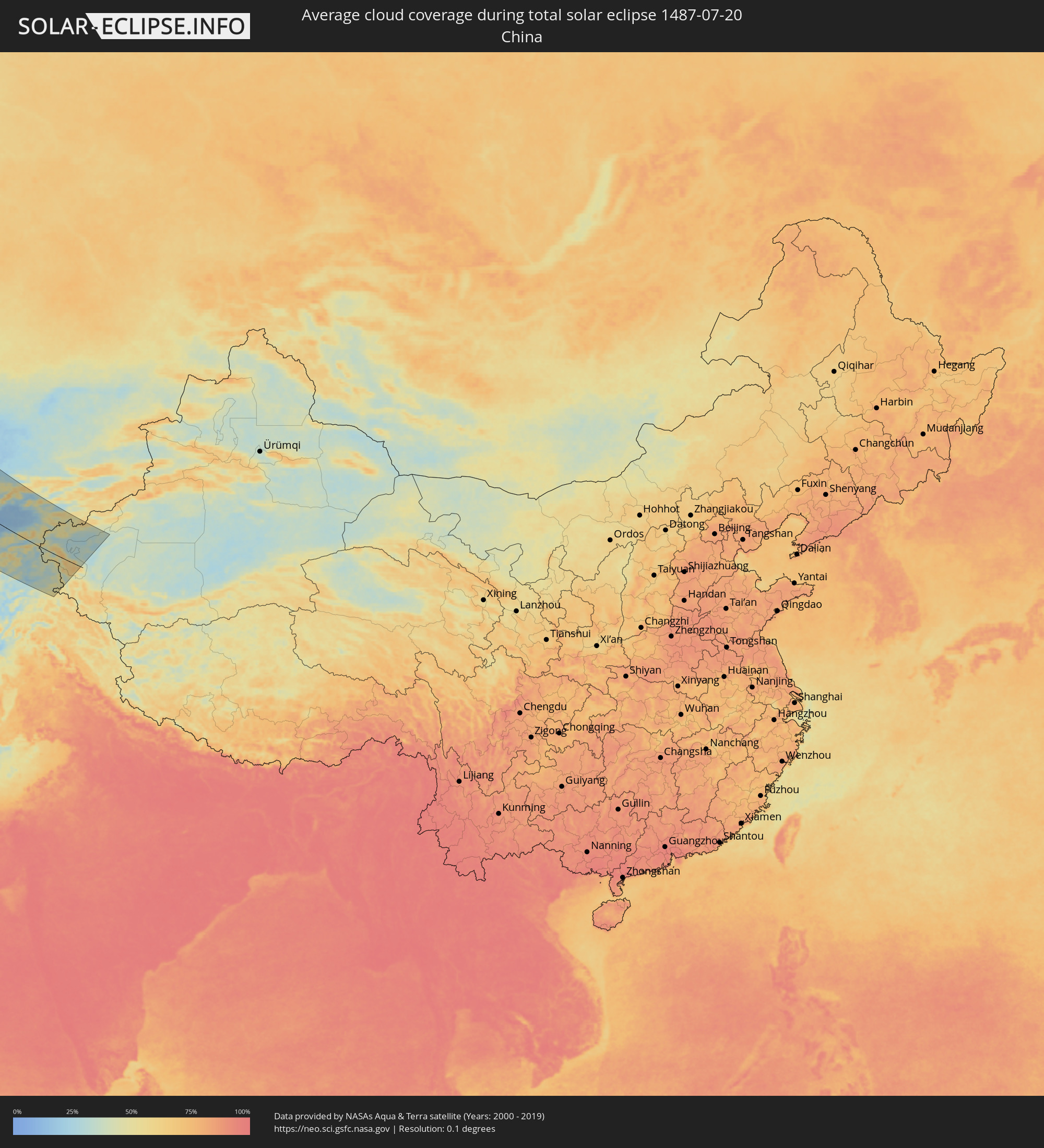 Volksrepublik China
Orte im Finsternispfad
Die nachfolgene Tabelle zeigt Städte und Orte mit mehr als 5.000 Einwohnern, die sich im Finsternispfad befinden. Städte mit mehr als 100.000 Einwohnern sind dick gekennzeichnet. Mit einem Klick auf den Ort öffnet sich eine Detailkarte die die Lage des jeweiligen Ortes zusammen mit dem Verlauf der zentralen Finsternis präsentiert.
| Ort | Typ | Dauer der Verfinsterung | Ortszeit bei maximaler Verfinsterung | Entfernung zur Zentrallinie | Ø Bewölkung |
|
Severodvinsk, Arkhangelskaya
|
total | - | 15:50:58 UTC+02:30 | 163 km | 67% |
|
Arkhangel’sk, Arkhangelskaya
|
total | - | 15:51:13 UTC+02:30 | 133 km | 65% |
|
Cheboksary, Chuvashia
|
total | - | 16:08:18 UTC+02:30 | 176 km | 64% |
|
Yoshkar-Ola, Mariy-El
|
total | - | 16:07:29 UTC+02:30 | 112 km | 64% |
|
Ulyanovsk, Ulyanovsk
|
total | - | 17:01:51 UTC+03:20 | 207 km | 58% |
|
Zelenodolsk, Tatarstan
|
total | - | 16:09:03 UTC+02:30 | 121 km | 62% |
|
Kazan, Tatarstan
|
total | - | 16:09:14 UTC+02:30 | 89 km | 66% |
|
Tol’yatti, Samara
|
total | - | 17:03:26 UTC+03:20 | 196 km | 51% |
|
Dimitrovgrad, Ulyanovsk
|
total | - | 17:02:13 UTC+03:20 | 142 km | 57% |
|
Kirov, Kirov
|
total | - | 16:04:10 UTC+02:30 | 76 km | 65% |
|
Chapayevsk, Samara
|
total | - | 17:04:28 UTC+03:20 | 208 km | 56% |
|
Novokuybyshevsk, Samara
|
total | - | 17:04:17 UTC+03:20 | 187 km | 56% |
|
Kirovo-Chepetsk, Kirov
|
total | - | 16:04:18 UTC+02:30 | 94 km | 64% |
|
Samara, Samara
|
total | - | 17:04:07 UTC+03:20 | 170 km | 60% |
|
Oral, Batys Qazaqstan
|
total | - | 17:12:49 UTC+03:25 | 216 km | 52% |
|
Nizhnekamsk, Tatarstan
|
total | - | 16:09:50 UTC+02:30 | 57 km | 63% |
|
Yelabuga, Tatarstan
|
total | - | 16:09:38 UTC+02:30 | 77 km | 60% |
|
Buzuluk, Orenburg
|
total | - | 17:47:17 UTC+04:02 | 76 km | 56% |
|
Al’met’yevsk, Tatarstan
|
total | - | 16:11:12 UTC+02:30 | 52 km | 64% |
|
Naberezhnyye Chelny, Tatarstan
|
total | - | 16:09:44 UTC+02:30 | 95 km | 63% |
|
Glazov, Udmurtiya
|
total | - | 16:55:26 UTC+03:20 | 220 km | 60% |
|
Bugul’ma, Tatarstan
|
total | - | 16:11:54 UTC+02:30 | 56 km | 62% |
|
Aqsay, Batys Qazaqstan
|
total | - | 17:13:02 UTC+03:25 | 126 km | 53% |
|
Izhevsk, Udmurtiya
|
total | - | 16:57:49 UTC+03:20 | 192 km | 61% |
|
Oktyabr’skiy, Bashkortostan
|
total | - | 17:44:19 UTC+04:02 | 97 km | 63% |
|
Tuymazy, Bashkortostan
|
total | - | 17:44:06 UTC+04:02 | 114 km | 62% |
|
Sarapul, Udmurtiya
|
total | - | 16:58:32 UTC+03:20 | 210 km | 60% |
|
Votkinsk, Udmurtiya
|
total | - | 16:57:31 UTC+03:20 | 245 km | 59% |
|
Chaykovskiy, Perm
|
total | - | 17:40:15 UTC+04:02 | 239 km | 59% |
|
Neftekamsk, Bashkortostan
|
total | - | 17:41:29 UTC+04:02 | 218 km | 57% |
|
Orenburg, Orenburg
|
total | - | 17:49:11 UTC+04:02 | 41 km | 59% |
|
Salavat, Bashkortostan
|
total | - | 17:46:22 UTC+04:02 | 172 km | 63% |
|
Sterlitamak, Bashkortostan
|
total | - | 17:45:56 UTC+04:02 | 188 km | 64% |
|
Ufa, Bashkortostan
|
total | - | 17:43:58 UTC+04:02 | 248 km | 59% |
|
Shubarkuduk, Aqtöbe
|
total | - | 17:16:35 UTC+03:25 | 56 km | 42% |
|
Aqtöbe, Aqtöbe
|
total | - | 17:14:36 UTC+03:25 | 62 km | 53% |
|
Kandyagash, Aqtöbe
|
total | - | 17:15:59 UTC+03:25 | 31 km | 49% |
|
Embi, Aqtöbe
|
total | - | 17:17:02 UTC+03:25 | 20 km | 44% |
|
Novotroitsk, Orenburg
|
total | - | 17:50:08 UTC+04:02 | 187 km | 57% |
|
Khromtau, Aqtöbe
|
total | - | 17:14:36 UTC+03:25 | 132 km | 51% |
|
Orsk, Orenburg
|
total | - | 17:50:07 UTC+04:02 | 202 km | 55% |
|
Shalqar, Aqtöbe
|
total | - | 17:18:35 UTC+03:25 | 33 km | 39% |
|
Aral, Qyzylorda
|
total | - | 18:16:30 UTC+04:21 | 74 km | 32% |
|
Ayteke Bi, Qyzylorda
|
total | - | 18:17:58 UTC+04:21 | 27 km | 26% |
|
Baikonur, Baikonur
|
total | - | 18:18:08 UTC+04:21 | 73 km | 24% |
|
Zhosaly, Qyzylorda
|
total | - | 18:18:11 UTC+04:21 | 104 km | 27% |
|
Dzhalagash, Qyzylorda
|
total | - | 18:18:42 UTC+04:21 | 103 km | 21% |
|
Kyzyl-Orda, Qyzylorda
|
total | - | 18:18:53 UTC+04:21 | 127 km | 17% |
|
Tasböget, Qyzylorda
|
total | - | 18:19:00 UTC+04:21 | 124 km | 17% |
|
Shīeli, Qyzylorda
|
total | - | 18:19:38 UTC+04:21 | 134 km | 17% |
|
Yanykurgan, Qyzylorda
|
total | - | 18:19:54 UTC+04:21 | 137 km | 18% |
|
Jizzax, Jizzax
|
total | - | 18:31:21 UTC+04:27 | 175 km | 11% |
|
Chardara, Ongtüstik Qazaqstan
|
total | - | 18:23:38 UTC+04:21 | 63 km | 12% |
|
Turkestan, Ongtüstik Qazaqstan
|
total | - | 18:20:33 UTC+04:21 | 134 km | 14% |
|
Asyqata, Ongtüstik Qazaqstan
|
total | - | 18:24:02 UTC+04:21 | 78 km | 8% |
|
Zomin, Jizzax
|
total | - | 18:31:24 UTC+04:27 | 164 km | 13% |
|
Kentau, Ongtüstik Qazaqstan
|
total | - | 18:20:09 UTC+04:21 | 166 km | 16% |
|
Atakent, Ongtüstik Qazaqstan
|
total | - | 18:24:04 UTC+04:21 | 76 km | 8% |
|
Kantagi, Ongtüstik Qazaqstan
|
total | - | 18:20:06 UTC+04:21 | 171 km | 15% |
|
Sirdaryo, Sirdaryo
|
total | - | 18:30:02 UTC+04:27 | 69 km | 8% |
|
Pakhtakoron, Viloyati Sughd
|
total | - | 18:38:19 UTC+04:35 | 129 km | 12% |
|
Guliston, Sirdaryo
|
total | - | 18:30:30 UTC+04:27 | 96 km | 10% |
|
Arys, Ongtüstik Qazaqstan
|
total | - | 18:21:40 UTC+04:21 | 83 km | 9% |
|
Yangiyer, Sirdaryo
|
total | - | 18:30:48 UTC+04:27 | 115 km | 12% |
|
Istaravshan, Viloyati Sughd
|
total | - | 18:38:34 UTC+04:35 | 140 km | 20% |
|
Yangiyŭl, Toshkent
|
total | - | 18:29:31 UTC+04:27 | 26 km | 8% |
|
Saryaghash, Ongtüstik Qazaqstan
|
total | - | 18:22:58 UTC+04:21 | 12 km | 12% |
|
Chulakkurgan, Ongtüstik Qazaqstan
|
total | - | 18:19:35 UTC+04:21 | 221 km | 21% |
|
Tashkent, Toshkent Shahri
|
total | - | 18:29:15 UTC+04:27 | 4 km | 11% |
|
Temirlanovka, Ongtüstik Qazaqstan
|
total | - | 18:21:16 UTC+04:21 | 120 km | 13% |
|
Bekobod, Toshkent
|
total | - | 18:30:44 UTC+04:27 | 99 km | 13% |
|
Bŭston, Viloyati Sughd
|
total | - | 18:37:36 UTC+04:35 | 68 km | 13% |
|
Bektemir, Toshkent Shahri
|
total | - | 18:29:17 UTC+04:27 | 4 km | 12% |
|
Piskent, Toshkent
|
total | - | 18:29:44 UTC+04:27 | 32 km | 12% |
|
Nov, Viloyati Sughd
|
total | - | 18:38:06 UTC+04:35 | 101 km | 13% |
|
Salor, Toshkent
|
total | - | 18:29:02 UTC+04:27 | 13 km | 13% |
|
Leninskoye, Ongtüstik Qazaqstan
|
total | - | 18:22:28 UTC+04:21 | 49 km | 21% |
|
Qibray, Toshkent
|
total | - | 18:28:59 UTC+04:27 | 19 km | 14% |
|
Proletar, Viloyati Sughd
|
total | - | 18:38:02 UTC+04:35 | 94 km | 13% |
|
Isfana, Batken
|
total | - | 19:01:42 UTC+04:58 | 124 km | 27% |
|
Suluktu, Batken
|
total | - | 19:01:33 UTC+04:58 | 113 km | 20% |
|
Chirchiq, Toshkent
|
total | - | 18:28:50 UTC+04:27 | 32 km | 16% |
|
Olmaliq, Toshkent
|
total | - | 18:29:44 UTC+04:27 | 26 km | 15% |
|
Shymkent, Ongtüstik Qazaqstan
|
total | - | 18:21:36 UTC+04:21 | 109 km | 20% |
|
Khŭjand, Viloyati Sughd
|
total | - | 18:37:50 UTC+04:35 | 78 km | 13% |
|
Taboshar, Viloyati Sughd
|
total | - | 18:37:25 UTC+04:35 | 50 km | 14% |
|
Parkent, Toshkent
|
total | - | 18:29:03 UTC+04:27 | 20 km | 16% |
|
Chkalov, Viloyati Sughd
|
total | - | 18:37:53 UTC+04:35 | 79 km | 11% |
|
Iskandar, Toshkent
|
total | - | 18:28:40 UTC+04:27 | 45 km | 19% |
|
Konsoy, Viloyati Sughd
|
total | - | 18:37:31 UTC+04:35 | 54 km | 12% |
|
Obigarm
|
total | - | 18:40:00 UTC+04:35 | 223 km | 25% |
|
Zhangatas, Zhambyl
|
total | - | 18:19:43 UTC+04:21 | 230 km | 19% |
|
Belyye Vody, Ongtüstik Qazaqstan
|
total | - | 18:21:21 UTC+04:21 | 131 km | 20% |
|
Roghun
|
total | - | 18:39:51 UTC+04:35 | 209 km | 25% |
|
Lenger, Ongtüstik Qazaqstan
|
total | - | 18:21:41 UTC+04:21 | 111 km | 25% |
|
Adrasmon, Viloyati Sughd
|
total | - | 18:37:11 UTC+04:35 | 27 km | 17% |
|
Yangiobod, Toshkent
|
total | - | 18:29:10 UTC+04:27 | 22 km | 21% |
|
Angren, Toshkent
|
total | - | 18:29:18 UTC+04:27 | 15 km | 18% |
|
Novobod
|
total | - | 18:39:26 UTC+04:35 | 175 km | 27% |
|
Vannovka, Ongtüstik Qazaqstan
|
total | - | 18:21:01 UTC+04:21 | 165 km | 25% |
|
Shaydon, Viloyati Sughd
|
total | - | 18:37:02 UTC+04:35 | 8 km | 16% |
|
Rasht
|
total | - | 18:39:20 UTC+04:35 | 164 km | 32% |
|
Konibodom, Viloyati Sughd
|
total | - | 18:37:32 UTC+04:35 | 40 km | 14% |
|
Karatau, Zhambyl
|
total | - | 18:20:03 UTC+04:21 | 230 km | 20% |
|
Isfara, Viloyati Sughd
|
total | - | 18:37:42 UTC+04:35 | 48 km | 18% |
|
Batken, Batken
|
total | - | 19:00:55 UTC+04:58 | 45 km | 19% |
|
Qo‘qon, Fergana
|
total | - | 18:29:42 UTC+04:27 | 5 km | 14% |
|
Chust Shahri, Namangan
|
total | - | 18:28:55 UTC+04:27 | 63 km | 15% |
|
Aydarken, Batken
|
total | - | 19:00:54 UTC+04:58 | 34 km | 40% |
|
Oltiariq, Fergana
|
total | - | 18:29:42 UTC+04:27 | 15 km | 16% |
|
To‘rqao‘rg‘on, Namangan
|
total | - | 18:28:50 UTC+04:27 | 74 km | 15% |
|
Kosonsoy, Namangan
|
total | - | 18:28:27 UTC+04:27 | 100 km | 17% |
|
Namangan, Namangan
|
total | - | 18:28:47 UTC+04:27 | 81 km | 16% |
|
Yangiqo‘rg‘on, Namangan
|
total | - | 18:28:29 UTC+04:27 | 102 km | 16% |
|
Toshloq, Fergana
|
total | - | 18:29:28 UTC+04:27 | 36 km | 15% |
|
Fergana, Fergana
|
total | - | 18:29:36 UTC+04:27 | 28 km | 17% |
|
Quvasoy, Fergana
|
total | - | 18:29:39 UTC+04:27 | 28 km | 19% |
|
Quva, Fergana
|
total | - | 18:29:18 UTC+04:27 | 53 km | 15% |
|
Uchqŭrghon Shahri, Namangan
|
total | - | 18:28:28 UTC+04:27 | 110 km | 15% |
|
Iradan, Batken
|
total | - | 19:00:10 UTC+04:58 | 30 km | 19% |
|
Haqqulobod, Namangan
|
total | - | 18:28:44 UTC+04:27 | 93 km | 16% |
|
Kyzyl-Kyya, Batken
|
total | - | 19:00:10 UTC+04:58 | 30 km | 19% |
|
Tash-Kumyr, Jalal-Abad
|
total | - | 18:58:36 UTC+04:58 | 138 km | 14% |
|
Asaka, Andijon
|
total | - | 18:29:04 UTC+04:27 | 72 km | 15% |
|
Andijon, Andijon
|
total | - | 18:28:50 UTC+04:27 | 90 km | 16% |
|
Nookat
|
total | - | 18:59:58 UTC+04:58 | 52 km | 25% |
|
Bazar-Korgon, Jalal-Abad
|
total | - | 18:58:50 UTC+04:58 | 131 km | 16% |
|
Qo‘rg‘ontepa, Andijon
|
total | - | 18:28:45 UTC+04:27 | 103 km | 17% |
|
Osh, Osh
|
total | - | 18:59:32 UTC+04:58 | 85 km | 20% |
|
Osh City, Osh City
|
total | - | 18:59:30 UTC+04:58 | 86 km | 20% |
|
Kara Suu, Osh
|
total | - | 18:59:15 UTC+04:58 | 104 km | 18% |
|
Toktogul, Jalal-Abad
|
total | - | 18:57:35 UTC+04:58 | 220 km | 24% |
|
Jalal-Abad, Jalal-Abad
|
total | - | 18:58:53 UTC+04:58 | 132 km | 19% |
|
Uzgen, Osh
|
total | - | 18:59:00 UTC+04:58 | 129 km | 20% |
|
Murghob, Gorno-Badakhshan
|
total | - | 18:39:03 UTC+04:35 | 100 km | 29% |
|
Kashgar, Xinjiang Uyghur Autonomous Region
|
total | - | 22:01:14 UTC+08:00 | 108 km | 32% |