Totale Sonnenfinsternis vom 03.09.1690
| Wochentag: | Sonntag |
| Maximale Dauer der Verfinsterung: | 02m13s |
| Maximale Breite des Finsternispfades: | 122 km |
| Saroszyklus: | 120 |
| Bedeckungsgrad: | 100% |
| Magnitude: | 1.0287 |
| Gamma: | 0.6173 |
Wo kann man die Sonnenfinsternis vom 03.09.1690 sehen?
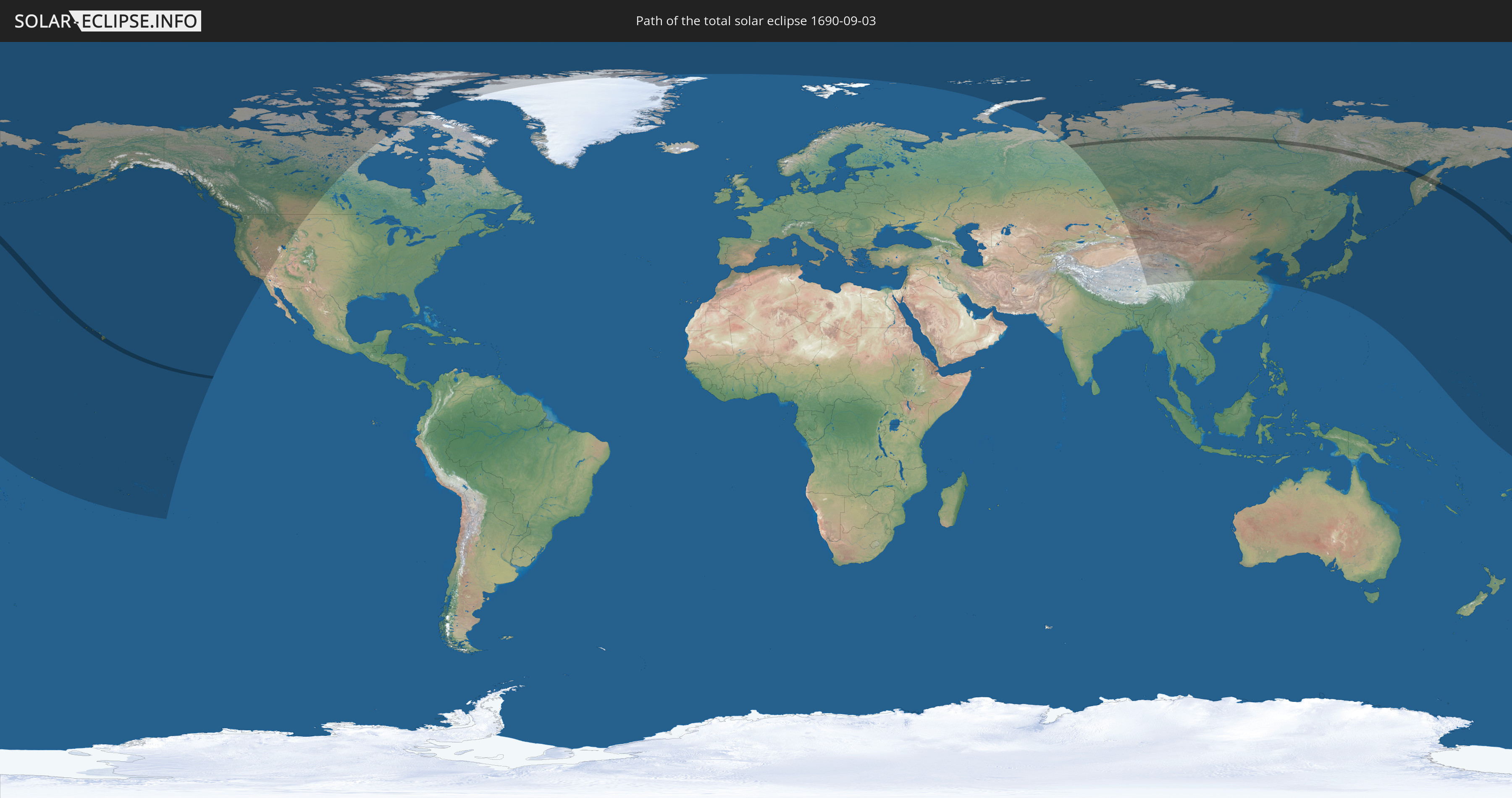
Die Sonnenfinsternis am 03.09.1690 kann man in 20 Ländern als partielle Sonnenfinsternis beobachten.
Der Finsternispfad verläuft durch 2 Länder. Nur in diesen Ländern ist sie als totale Sonnenfinsternis zu sehen.
In den folgenden Ländern ist die Sonnenfinsternis total zu sehen
 Russland
 Vereinigte Staaten
In den folgenden Ländern ist die Sonnenfinsternis partiell zu sehen


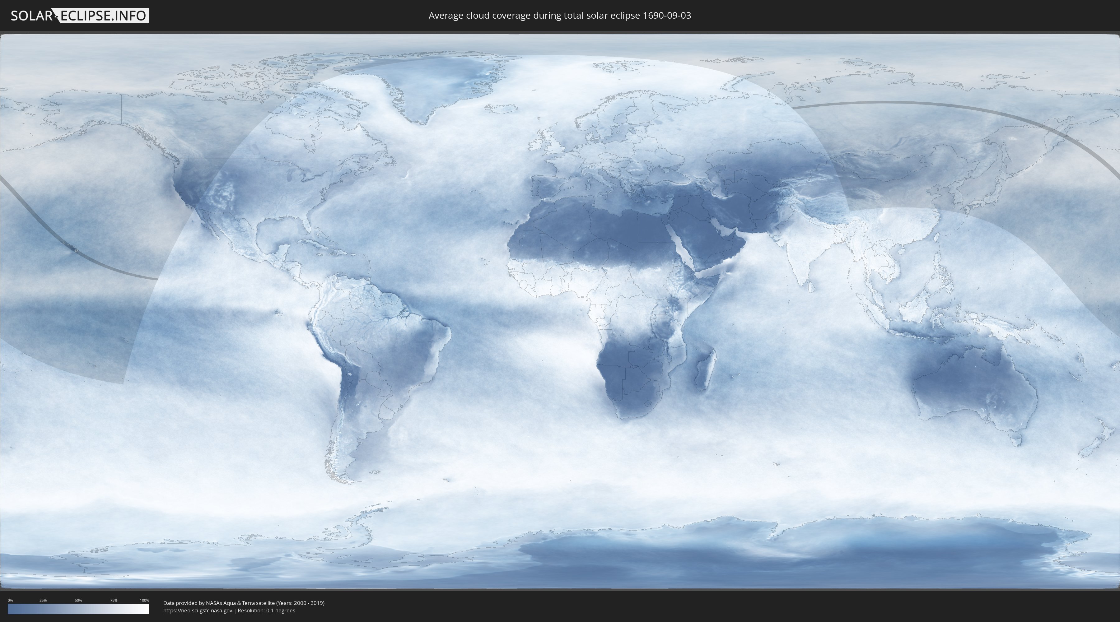
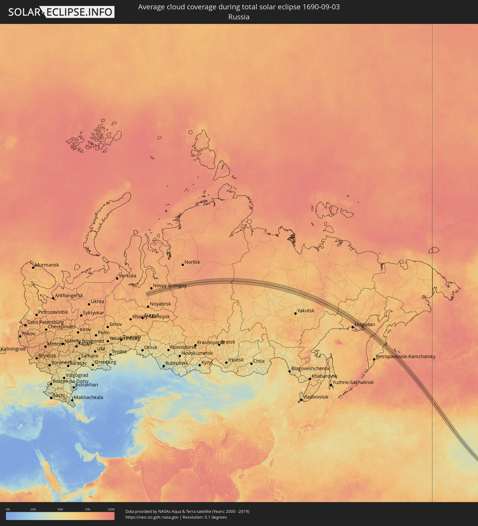
Wie wird das Wetter während der totalen Sonnenfinsternis am 03.09.1690?
Wo ist der beste Ort, um die totale Sonnenfinsternis vom 03.09.1690 zu beobachten?
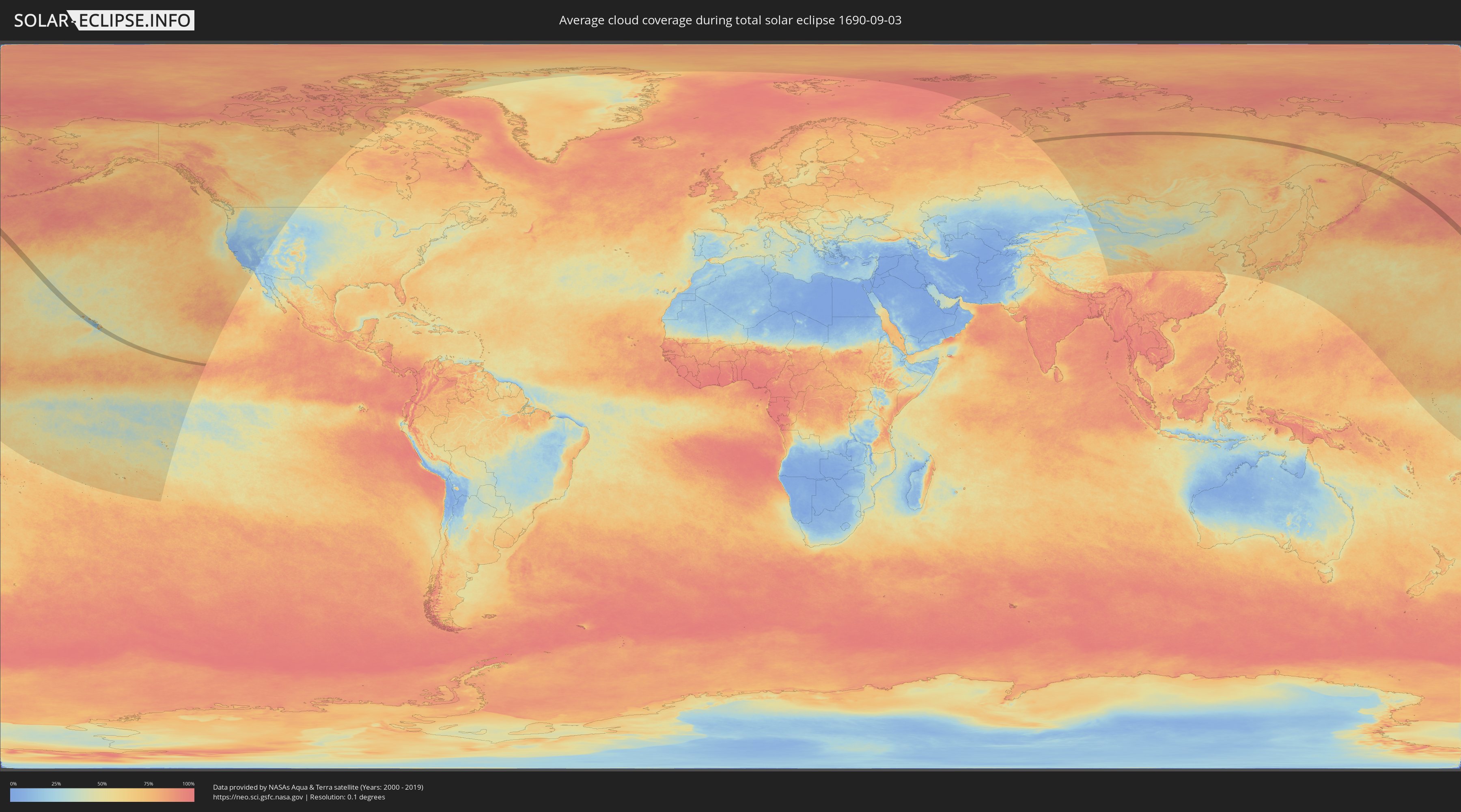
Die folgenden Karten zeigen die durchschnittliche Bewölkung für den Tag, an dem die totale Sonnenfinsternis
stattfindet. Mit Hilfe der Karten lässt sich der Ort entlang des Finsternispfades eingrenzen,
der die besten Aussichen auf einen klaren wolkenfreien Himmel bietet.
Trotzdem muss man immer lokale Gegenenheiten beachten und sollte sich genau über das Wetter an seinem
gewählten Beobachtungsort informieren.
Die Daten stammen von den beiden NASA-Satelliten
AQUA und TERRA
und wurden über einen Zeitraum von 19 Jahren (2000 - 2019) gemittelt.
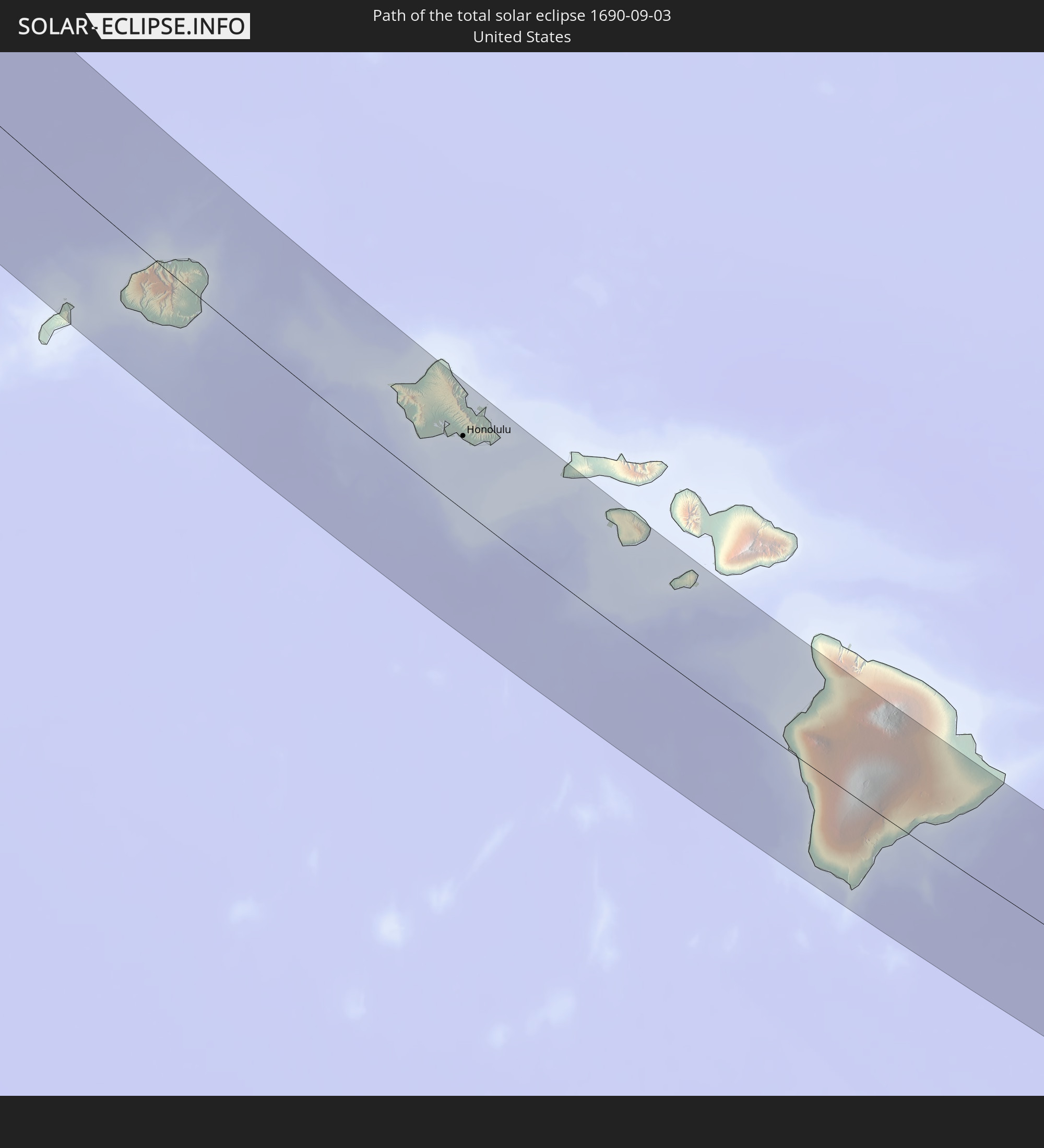
Detaillierte Länderkarten
 Russland
 Vereinigte Staaten
Orte im Finsternispfad
Die nachfolgene Tabelle zeigt Städte und Orte mit mehr als 5.000 Einwohnern, die sich im Finsternispfad befinden. Städte mit mehr als 100.000 Einwohnern sind dick gekennzeichnet. Mit einem Klick auf den Ort öffnet sich eine Detailkarte die die Lage des jeweiligen Ortes zusammen mit dem Verlauf der zentralen Finsternis präsentiert.
| Ort | Typ | Dauer der Verfinsterung | Ortszeit bei maximaler Verfinsterung | Entfernung zur Zentrallinie | Ø Bewölkung |
 Wailua Homesteads, Hawaii
|
total | - | 15:43:47 UTC-10:30 | 1 km | 77% |
|
Lihue, Hawaii
|
total | - | 15:43:58 UTC-10:30 | 6 km | 67% |
|
Kapa‘a, Hawaii
|
total | - | 15:43:50 UTC-10:30 | 5 km | 55% |
|
Mākaha, Hawaii
|
total | - | 15:45:52 UTC-10:30 | 25 km | 67% |
|
Waianae, Hawaii
|
total | - | 15:45:57 UTC-10:30 | 24 km | 59% |
|
Mā‘ili, Hawaii
|
total | - | 15:45:59 UTC-10:30 | 23 km | 59% |
|
Nānākuli, Hawaii
|
total | - | 15:46:03 UTC-10:30 | 23 km | 59% |
|
Makakilo, Hawaii
|
total | - | 15:46:11 UTC-10:30 | 23 km | 65% |
|
Makakilo City, Hawaii
|
total | - | 15:46:11 UTC-10:30 | 23 km | 47% |
|
Schofield Barracks, Hawaii
|
total | - | 15:45:55 UTC-10:30 | 37 km | 72% |
|
‘Ewa Villages, Hawaii
|
total | - | 15:46:14 UTC-10:30 | 25 km | 46% |
|
‘Ewa Gentry, Hawaii
|
total | - | 15:46:15 UTC-10:30 | 26 km | 46% |
|
Village Park, Hawaii
|
total | - | 15:46:08 UTC-10:30 | 31 km | 59% |
|
Royal Kunia, Hawaii
|
total | - | 15:46:09 UTC-10:30 | 31 km | 59% |
|
Wahiawā, Hawaii
|
total | - | 15:45:57 UTC-10:30 | 40 km | 62% |
|
Waipi‘o Acres, Hawaii
|
total | - | 15:46:01 UTC-10:30 | 38 km | 62% |
|
Waipahu, Hawaii
|
total | - | 15:46:10 UTC-10:30 | 31 km | 59% |
|
‘Ewa Beach, Hawaii
|
total | - | 15:46:18 UTC-10:30 | 25 km | 46% |
|
Mililani Town, Hawaii
|
total | - | 15:46:04 UTC-10:30 | 37 km | 62% |
|
Waipio, Hawaii
|
total | - | 15:46:07 UTC-10:30 | 35 km | 59% |
|
Pearl City, Hawaii
|
total | - | 15:46:11 UTC-10:30 | 34 km | 59% |
|
Hickam Field, Hawaii
|
total | - | 15:46:18 UTC-10:30 | 30 km | 46% |
|
Waimalu, Hawaii
|
total | - | 15:46:11 UTC-10:30 | 37 km | 59% |
|
‘Aiea, Hawaii
|
total | - | 15:46:14 UTC-10:30 | 36 km | 59% |
|
Hālawa, Hawaii
|
total | - | 15:46:15 UTC-10:30 | 36 km | 59% |
|
Hālawa Heights, Hawaii
|
total | - | 15:46:16 UTC-10:30 | 37 km | 59% |
|
Honolulu, Hawaii
|
total | - | 15:46:26 UTC-10:30 | 34 km | 46% |
|
‘Āhuimanu, Hawaii
|
total | - | 15:46:12 UTC-10:30 | 47 km | 74% |
|
Kaneohe, Hawaii
|
total | - | 15:46:19 UTC-10:30 | 46 km | 74% |
|
Marine Corps Base Hawaii - MCBH, Hawaii
|
total | - | 15:46:16 UTC-10:30 | 53 km | 57% |
|
Kailua, Hawaii
|
total | - | 15:46:21 UTC-10:30 | 50 km | 57% |
|
Waimanalo, Hawaii
|
total | - | 15:46:28 UTC-10:30 | 46 km | 49% |
|
Kailua-Kona, Hawaii
|
total | - | 15:50:52 UTC-10:30 | 1 km | 51% |
|
Kalaoa, Hawaii
|
total | - | 15:50:43 UTC-10:30 | 10 km | 61% |
|
Hōlualoa, Hawaii
|
total | - | 15:50:56 UTC-10:30 | 2 km | 79% |
|
Waikoloa Village, Hawaii
|
total | - | 15:50:27 UTC-10:30 | 38 km | 51% |
|
Waimea, Hawaii
|
total | - | 15:50:24 UTC-10:30 | 56 km | 38% |
 Urengoy, Yamalo-Nenetskiy Avtonomnyy Okrug
|
total | - | 03:56:49 UTC+04:02 | 33 km | 78% |
|
Klyuchi, Kamtsjatka
|
total | - | 11:04:20 UTC+10:34 | 48 km | 72% |