Totale Sonnenfinsternis vom 25.05.1770
| Wochentag: | Freitag |
| Maximale Dauer der Verfinsterung: | 05m31s |
| Maximale Breite des Finsternispfades: | 211 km |
| Saroszyklus: | 124 |
| Bedeckungsgrad: | 100% |
| Magnitude: | 1.0634 |
| Gamma: | 0.176 |
Wo kann man die Sonnenfinsternis vom 25.05.1770 sehen?
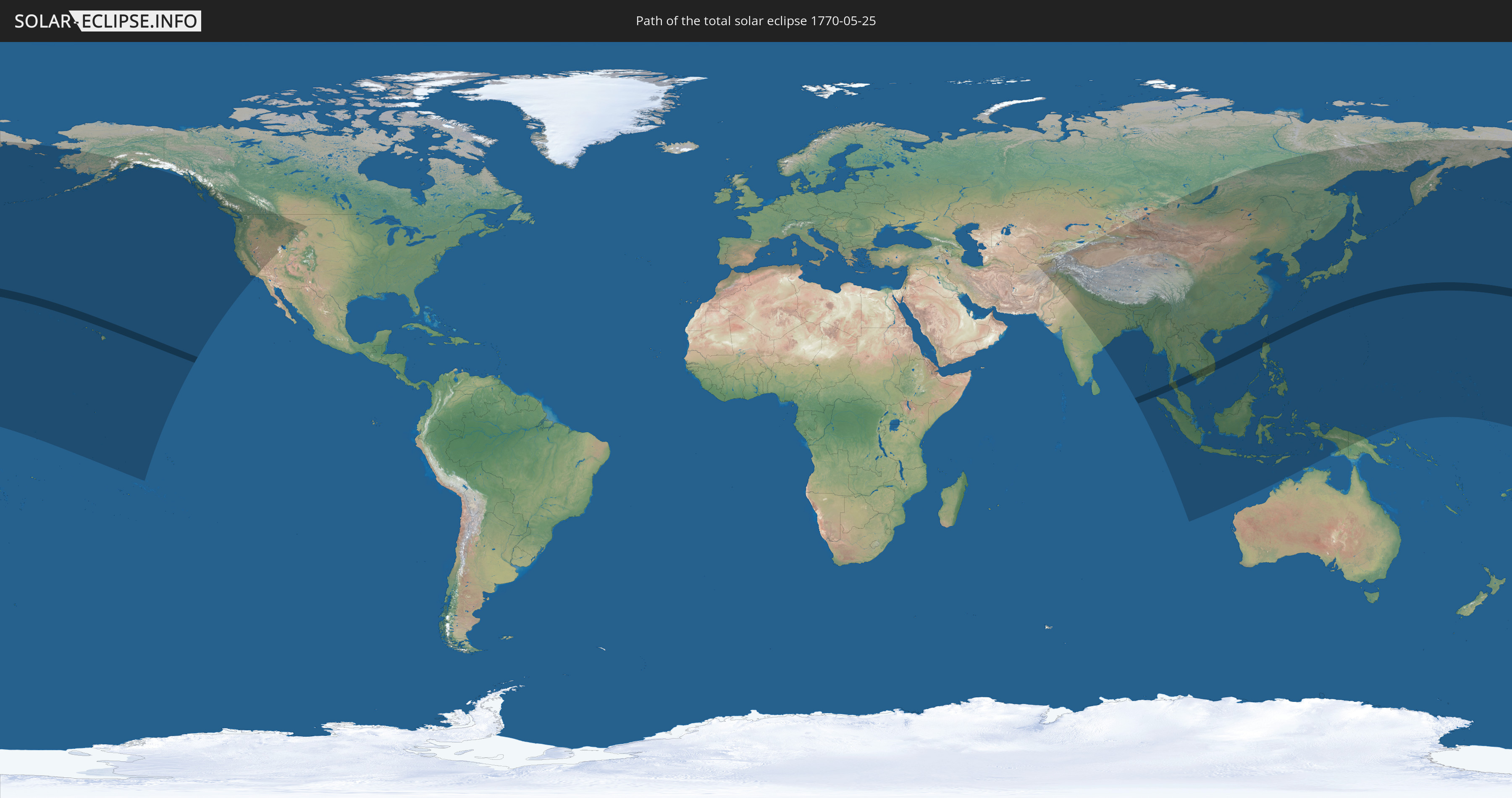
Die Sonnenfinsternis am 25.05.1770 kann man in 44 Ländern als partielle Sonnenfinsternis beobachten.
Der Finsternispfad verläuft durch 6 Länder. Nur in diesen Ländern ist sie als totale Sonnenfinsternis zu sehen.
In den folgenden Ländern ist die Sonnenfinsternis total zu sehen
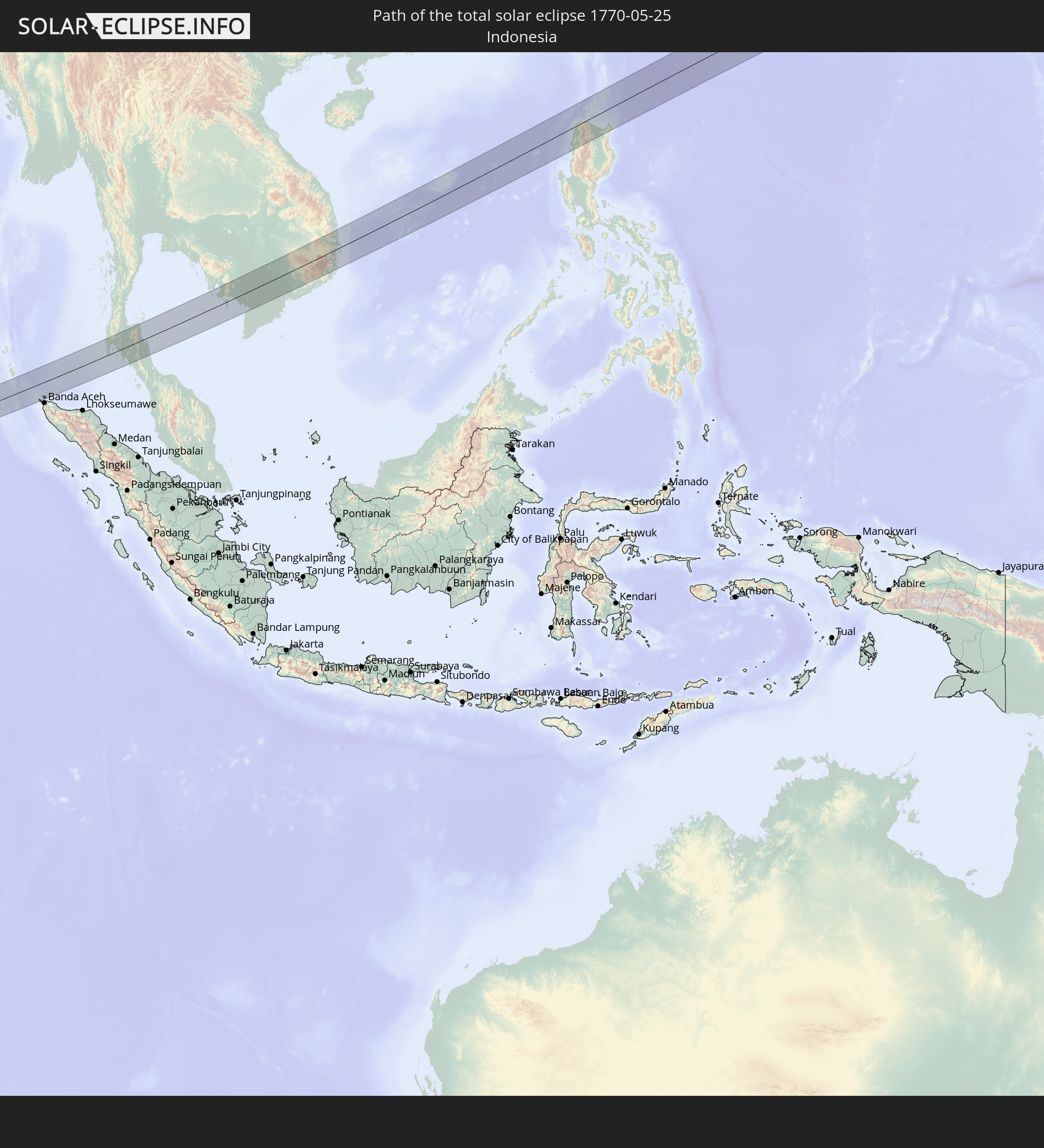 Indonesien
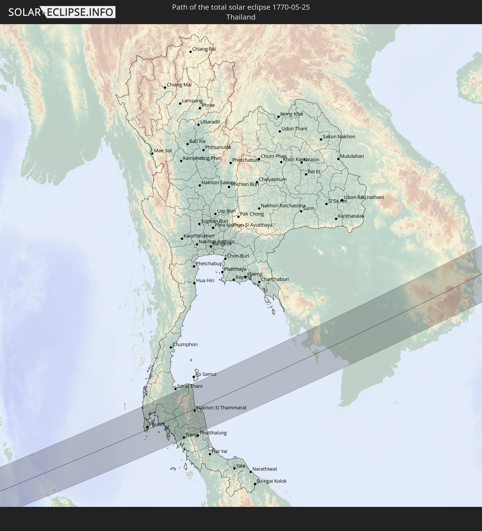 Thailand
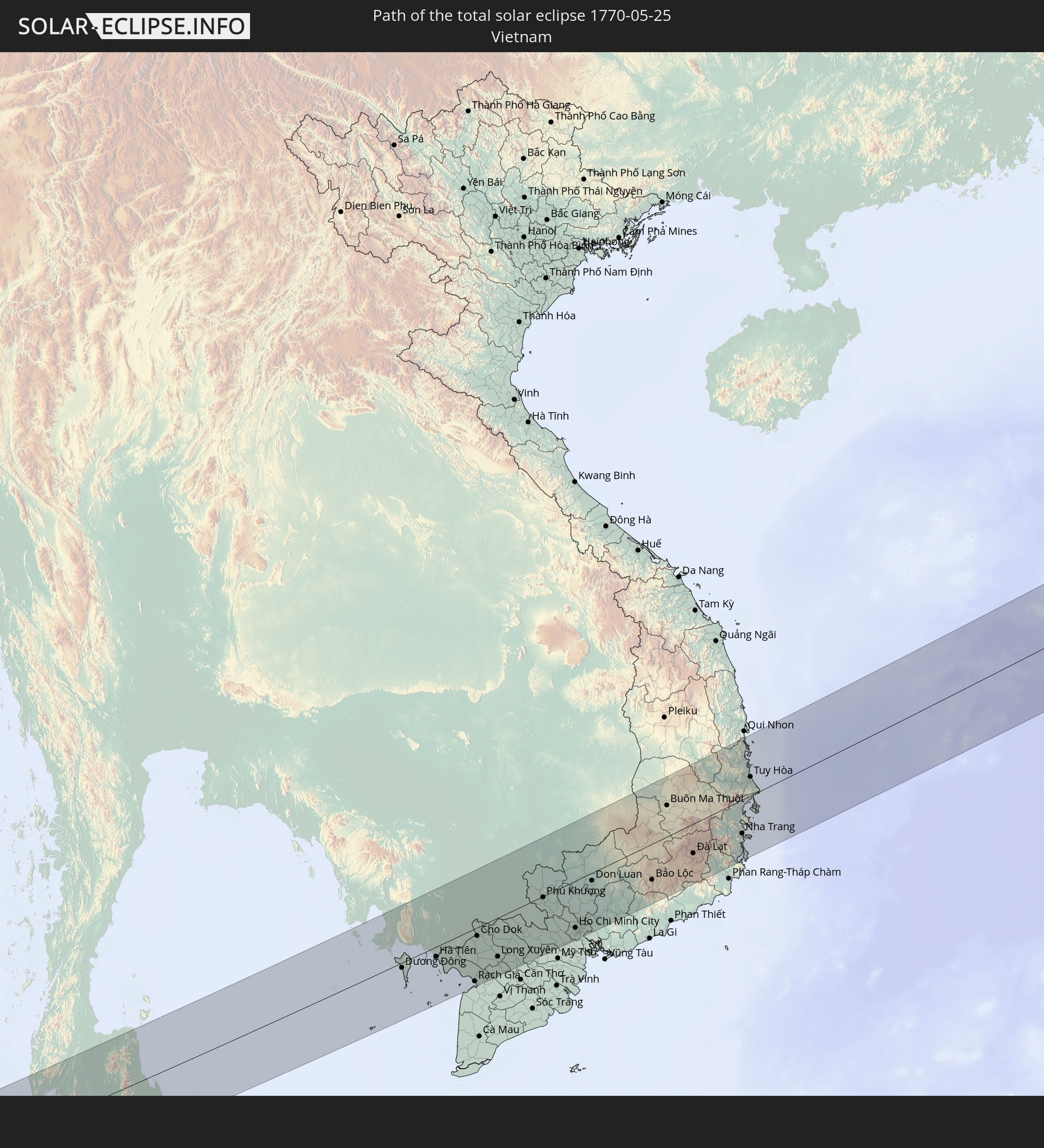 Vietnam
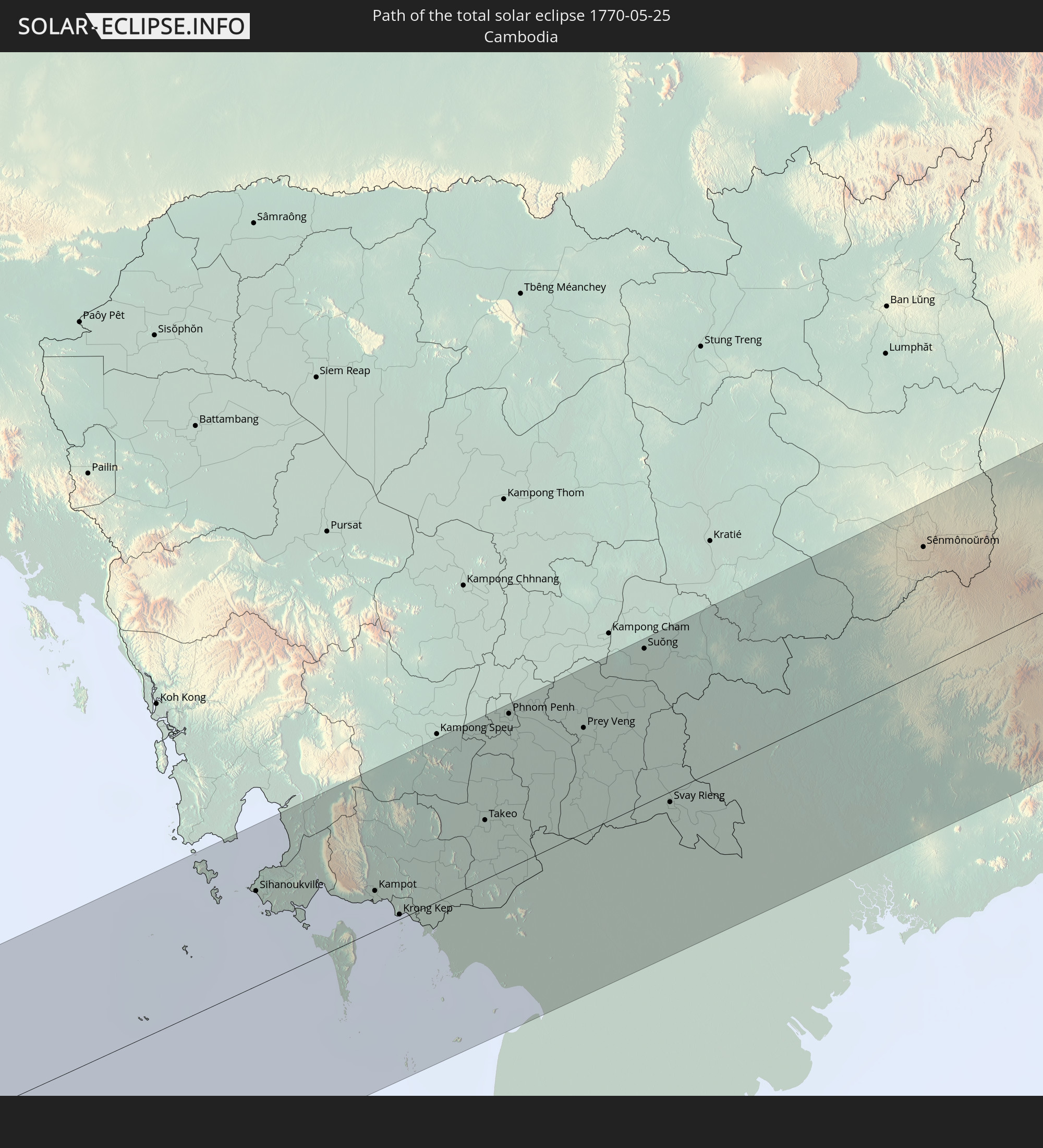 Kambodscha
 Philippinen
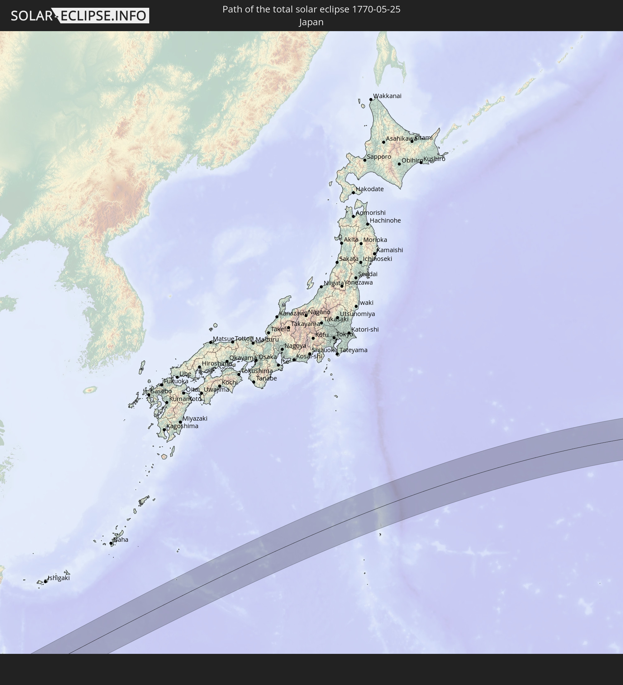 Japan
Japan
In den folgenden Ländern ist die Sonnenfinsternis partiell zu sehen
 Russland
 Vereinigte Staaten
 United States Minor Outlying Islands
 Kiribati
 Cookinseln
 Französisch-Polynesien
 Kanada
 Kasachstan
 Usbekistan
 Afghanistan
 Pakistan
 Tadschikistan
 Indien
 Kirgisistan
 Volksrepublik China
 Nepal
Nepal
 Mongolei
 Bangladesch
 Bhutan
 Myanmar
 Indonesien
 Thailand
 Malaysia
 Laos
Laos
 Vietnam
 Kambodscha
 Singapur
 Weihnachtsinsel
 Australien
 Macau
Macau
 Hongkong
 Brunei
 Taiwan
 Philippinen
 Japan
Japan
 Osttimor
 Nordkorea
 Südkorea
 Palau
Palau
 Föderierte Staaten von Mikronesien
 Papua-Neuguinea
 Guam
Guam
 Nördliche Marianen
 Marshallinseln
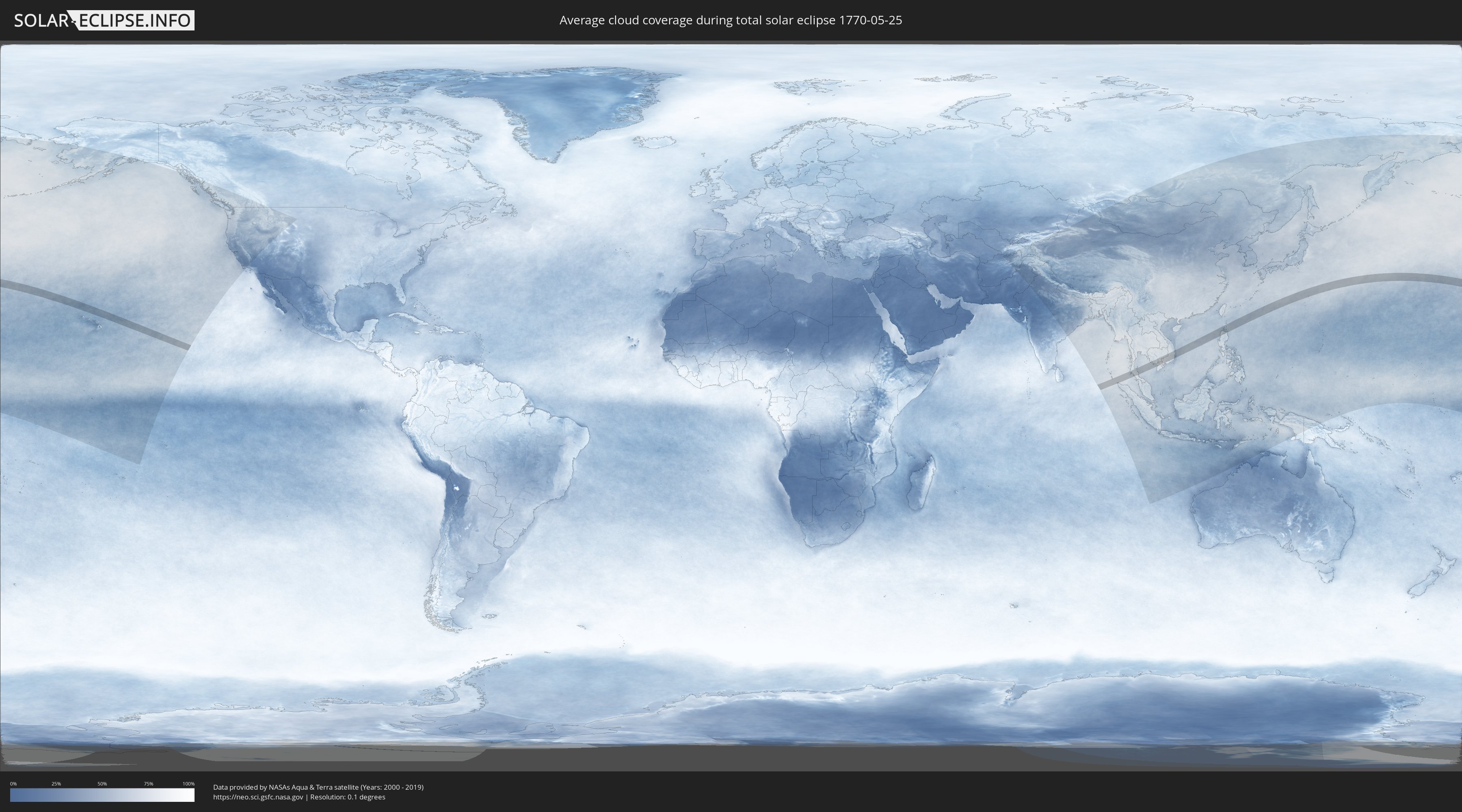
Wie wird das Wetter während der totalen Sonnenfinsternis am 25.05.1770?
Wo ist der beste Ort, um die totale Sonnenfinsternis vom 25.05.1770 zu beobachten?
Die folgenden Karten zeigen die durchschnittliche Bewölkung für den Tag, an dem die totale Sonnenfinsternis
stattfindet. Mit Hilfe der Karten lässt sich der Ort entlang des Finsternispfades eingrenzen,
der die besten Aussichen auf einen klaren wolkenfreien Himmel bietet.
Trotzdem muss man immer lokale Gegenenheiten beachten und sollte sich genau über das Wetter an seinem
gewählten Beobachtungsort informieren.
Die Daten stammen von den beiden NASA-Satelliten
AQUA und TERRA
und wurden über einen Zeitraum von 19 Jahren (2000 - 2019) gemittelt.

Detaillierte Länderkarten
 Indonesien
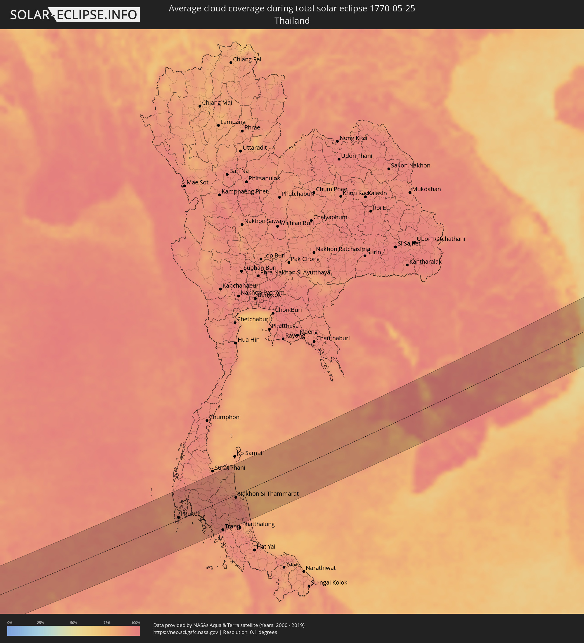 Thailand
 Vietnam
 Kambodscha
 Philippinen
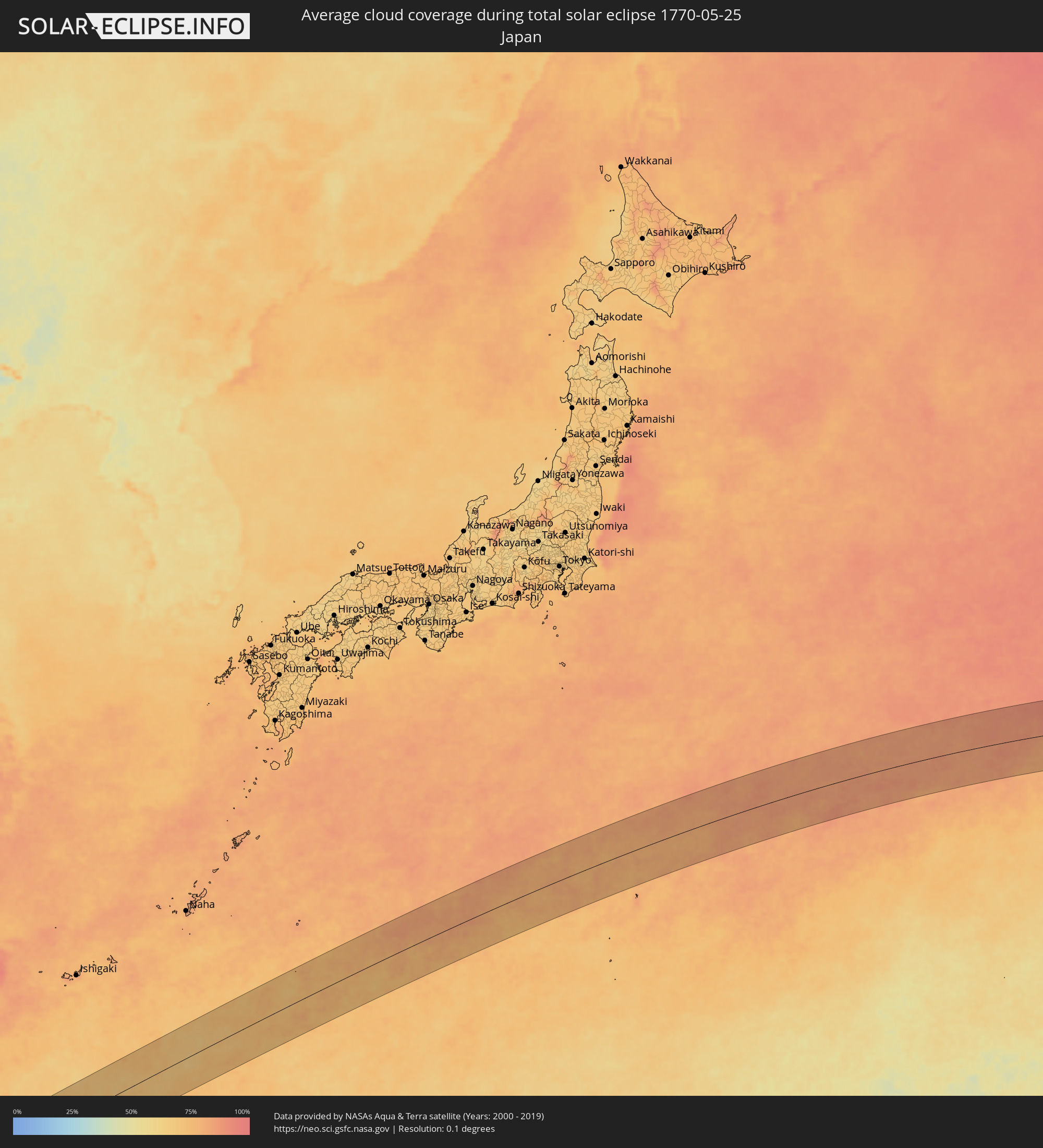 Japan
Japan
Orte im Finsternispfad
Die nachfolgene Tabelle zeigt Städte und Orte mit mehr als 5.000 Einwohnern, die sich im Finsternispfad befinden. Städte mit mehr als 100.000 Einwohnern sind dick gekennzeichnet. Mit einem Klick auf den Ort öffnet sich eine Detailkarte die die Lage des jeweiligen Ortes zusammen mit dem Verlauf der zentralen Finsternis präsentiert.
| Ort | Typ | Dauer der Verfinsterung | Ortszeit bei maximaler Verfinsterung | Entfernung zur Zentrallinie | Ø Bewölkung |
|
Sabang, Aceh
|
total | - | 06:54:37 UTC+07:07 | 66 km | 88% |
|
Patong, Phuket
|
total | - | 06:30:43 UTC+06:42 | 11 km | 87% |
|
Ban Karon, Phuket
|
total | - | 06:30:41 UTC+06:42 | 6 km | 85% |
|
Rawai, Phuket
|
total | - | 06:30:38 UTC+06:42 | 2 km | 85% |
|
Kathu, Phuket
|
total | - | 06:30:43 UTC+06:42 | 12 km | 87% |
|
Ban Chalong, Phuket
|
total | - | 06:30:40 UTC+06:42 | 4 km | 85% |
|
Wichit, Phuket
|
total | - | 06:30:42 UTC+06:42 | 7 km | 90% |
|
Ban Talat Nua, Phuket
|
total | - | 06:30:42 UTC+06:42 | 6 km | 90% |
|
Ban Ko Kaeo, Phuket
|
total | - | 06:30:44 UTC+06:42 | 11 km | 90% |
|
Phuket, Phuket
|
total | - | 06:30:42 UTC+06:42 | 6 km | 90% |
|
Ban Talat Yai, Phuket
|
total | - | 06:30:42 UTC+06:42 | 6 km | 90% |
|
Ban Ratsada, Phuket
|
total | - | 06:30:43 UTC+06:42 | 8 km | 90% |
|
Phang Nga, Phangnga
|
total | - | 06:31:06 UTC+06:42 | 58 km | 92% |
|
Ban Phru Nai, Phangnga
|
total | - | 06:30:46 UTC+06:42 | 4 km | 88% |
|
Ao Luek, Krabi
|
total | - | 06:31:04 UTC+06:42 | 42 km | 91% |
|
Ban Ao Nang, Phangnga
|
total | - | 06:30:50 UTC+06:42 | 4 km | 87% |
|
Krabi, Krabi
|
total | - | 06:30:51 UTC+06:42 | 2 km | 89% |
|
Nuea Khlong, Krabi
|
total | - | 06:30:51 UTC+06:42 | 2 km | 90% |
|
Saladan, Krabi
|
total | - | 06:30:33 UTC+06:42 | 50 km | 86% |
|
Chai Buri, Surat Thani
|
total | - | 06:31:08 UTC+06:42 | 35 km | 93% |
|
Ko Lanta, Krabi
|
total | - | 06:30:30 UTC+06:42 | 60 km | 87% |
|
Ban Na San, Surat Thani
|
total | - | 06:31:24 UTC+06:42 | 57 km | 91% |
|
Wiang Sa, Surat Thani
|
total | - | 06:31:17 UTC+06:42 | 40 km | 92% |
|
Tham Phannara, Nakhon Si Thammarat
|
total | - | 06:31:08 UTC+06:42 | 16 km | 93% |
|
Chawang, Nakhon Si Thammarat
|
total | - | 06:31:08 UTC+06:42 | 12 km | 94% |
|
Trang, Trang
|
total | - | 06:30:32 UTC+06:42 | 81 km | 94% |
|
Huai Yot, Trang
|
total | - | 06:30:42 UTC+06:42 | 59 km | 92% |
|
Thung Song, Nakhon Si Thammarat
|
total | - | 06:30:58 UTC+06:42 | 22 km | 94% |
|
Ron Phibun, Nakhon Si Thammarat
|
total | - | 06:30:59 UTC+06:42 | 29 km | 92% |
|
Nakhon Si Thammarat, Nakhon Si Thammarat
|
total | - | 06:31:11 UTC+06:42 | 8 km | 94% |
|
Pak Phanang, Nakhon Si Thammarat
|
total | - | 06:31:08 UTC+06:42 | 27 km | 87% |
|
Sihanoukville, Preah Sihanouk
|
total | - | 06:33:22 UTC+06:42 | 52 km | 88% |
|
Dương Đông, Kiến Giang
|
total | - | 06:57:45 UTC+07:06 | 8 km | 88% |
|
Kampot, Kampot
|
total | - | 06:33:31 UTC+06:42 | 22 km | 85% |
|
Krong Kep, Kep
|
total | - | 06:33:27 UTC+06:42 | 3 km | 81% |
|
Hà Tiên, Kiến Giang
|
total | - | 06:58:00 UTC+07:06 | 15 km | 85% |
|
Phumĭ Véal Srê, Takeo
|
total | - | 06:33:58 UTC+06:42 | 31 km | 97% |
|
Takeo, Takeo
|
total | - | 06:33:59 UTC+06:42 | 32 km | 97% |
|
Phnom Penh, Phnom Penh
|
total | - | 06:34:30 UTC+06:42 | 83 km | 94% |
|
Ta Khmau, Kandal
|
total | - | 06:34:27 UTC+06:42 | 74 km | 86% |
|
Rạch Giá, Kiến Giang
|
total | - | 06:57:51 UTC+07:06 | 80 km | 91% |
|
Cho Dok, An Giang
|
total | - | 06:58:26 UTC+07:06 | 13 km | 88% |
|
Prey Veng, Prey Veng
|
total | - | 06:34:33 UTC+06:42 | 57 km | 92% |
|
Long Xuyên, An Giang
|
total | - | 06:58:16 UTC+07:06 | 59 km | 90% |
|
Cao Lãnh, Đồng Tháp
|
total | - | 06:58:23 UTC+07:06 | 61 km | 90% |
|
Suŏng, Tboung Khmum
|
total | - | 06:35:01 UTC+06:42 | 84 km | 96% |
|
Sadek, Đồng Tháp
|
total | - | 06:58:16 UTC+07:06 | 84 km | 93% |
|
Svay Rieng, Svay Rieng
|
total | - | 06:34:21 UTC+06:42 | 6 km | 94% |
|
Tây Ninh, Tây Ninh
|
total | - | 06:59:14 UTC+07:06 | 3 km | 95% |
|
Phú Khương, Tây Ninh
|
total | - | 06:59:13 UTC+07:06 | 2 km | 95% |
|
Củ Chi, Ho Chi Minh City
|
total | - | 06:59:04 UTC+07:06 | 50 km | 97% |
|
Bình Long, Bình Phước
|
total | - | 06:59:41 UTC+07:06 | 13 km | 93% |
|
Ho Chi Minh City, Ho Chi Minh City
|
total | - | 06:58:59 UTC+07:06 | 71 km | 96% |
|
Thủ Dầu Một, Bình Dương
|
total | - | 06:59:07 UTC+07:06 | 56 km | 94% |
|
Biên Hòa, Đồng Nai
|
total | - | 06:59:09 UTC+07:06 | 68 km | 94% |
|
Don Luan, Bình Phước
|
total | - | 06:59:41 UTC+07:06 | 12 km | 94% |
|
Sênmônoŭrôm, Mondolkiri
|
total | - | 06:36:00 UTC+06:42 | 66 km | 93% |
|
Gia Nghĩa, Ðắk Nông
|
total | - | 07:00:23 UTC+07:06 | 3 km | 89% |
|
Bảo Lộc, Lâm Đồng
|
total | - | 07:00:01 UTC+07:06 | 54 km | 88% |
|
Buôn Ma Thuột, Ðắc Lắk
|
total | - | 07:01:07 UTC+07:06 | 47 km | 91% |
|
Đinh Văn, Lâm Đồng
|
total | - | 07:00:24 UTC+07:06 | 51 km | 86% |
|
Ðà Lạt, Lâm Đồng
|
total | - | 07:00:37 UTC+07:06 | 44 km | 88% |
|
Cam Ranh, Khánh Hòa
|
total | - | 07:00:54 UTC+07:06 | 81 km | 73% |
|
Nha Trang, Khánh Hòa
|
total | - | 07:01:12 UTC+07:06 | 51 km | 71% |
|
Sông Cầu, Phú Yên
|
total | - | 07:02:21 UTC+07:06 | 69 km | 81% |
|
Tuy Hòa, Phú Yên
|
total | - | 07:02:03 UTC+07:06 | 28 km | 87% |
|
Vigan, Ilocos
|
total | - | 08:07:51 UTC+08:00 | 71 km | 78% |
|
Bantay, Ilocos
|
total | - | 08:07:52 UTC+08:00 | 70 km | 78% |
|
Cabugao, Ilocos
|
total | - | 08:08:10 UTC+08:00 | 53 km | 86% |
|
Batac City, Ilocos
|
total | - | 08:08:35 UTC+08:00 | 32 km | 85% |
|
San Nicolas, Ilocos
|
total | - | 08:08:45 UTC+08:00 | 22 km | 81% |
|
Laoag, Ilocos
|
total | - | 08:08:47 UTC+08:00 | 20 km | 81% |
|
Bacarra, Ilocos
|
total | - | 08:08:52 UTC+08:00 | 15 km | 76% |
|
Pasuquin, Ilocos
|
total | - | 08:08:58 UTC+08:00 | 8 km | 76% |
|
Sarrat, Ilocos
|
total | - | 08:08:47 UTC+08:00 | 26 km | 81% |
|
Vintar, Ilocos
|
total | - | 08:08:52 UTC+08:00 | 19 km | 81% |
|
Dingras, Ilocos
|
total | - | 08:08:46 UTC+08:00 | 34 km | 88% |
|
Claveria, Cagayan Valley
|
total | - | 08:09:46 UTC+08:00 | 3 km | 74% |
|
Cabaritan East, Cagayan Valley
|
total | - | 08:09:57 UTC+08:00 | 42 km | 77% |
|
Ballesteros, Cagayan Valley
|
total | - | 08:09:58 UTC+08:00 | 44 km | 77% |
|
Lasam, Cagayan Valley
|
total | - | 08:09:39 UTC+08:00 | 82 km | 72% |
|
Aparri, Cagayan Valley
|
total | - | 08:10:02 UTC+08:00 | 56 km | 71% |
|
Magapit, Cagayan Valley
|
total | - | 08:09:48 UTC+08:00 | 79 km | 77% |
|
Magapit, Aguiguican, Cagayan Valley
|
total | - | 08:09:47 UTC+08:00 | 82 km | 77% |
|
Gonzaga, Cagayan Valley
|
total | - | 08:10:17 UTC+08:00 | 83 km | 75% |
|
Santa Ana, Cagayan Valley
|
total | - | 08:10:42 UTC+08:00 | 69 km | 64% |