Totale Sonnenfinsternis vom 29.06.1927
| Wochentag: | Mittwoch |
| Maximale Dauer der Verfinsterung: | 00m50s |
| Maximale Breite des Finsternispfades: | 77 km |
| Saroszyklus: | 145 |
| Bedeckungsgrad: | 100% |
| Magnitude: | 1.0128 |
| Gamma: | 0.8163 |
Wo kann man die Sonnenfinsternis vom 29.06.1927 sehen?
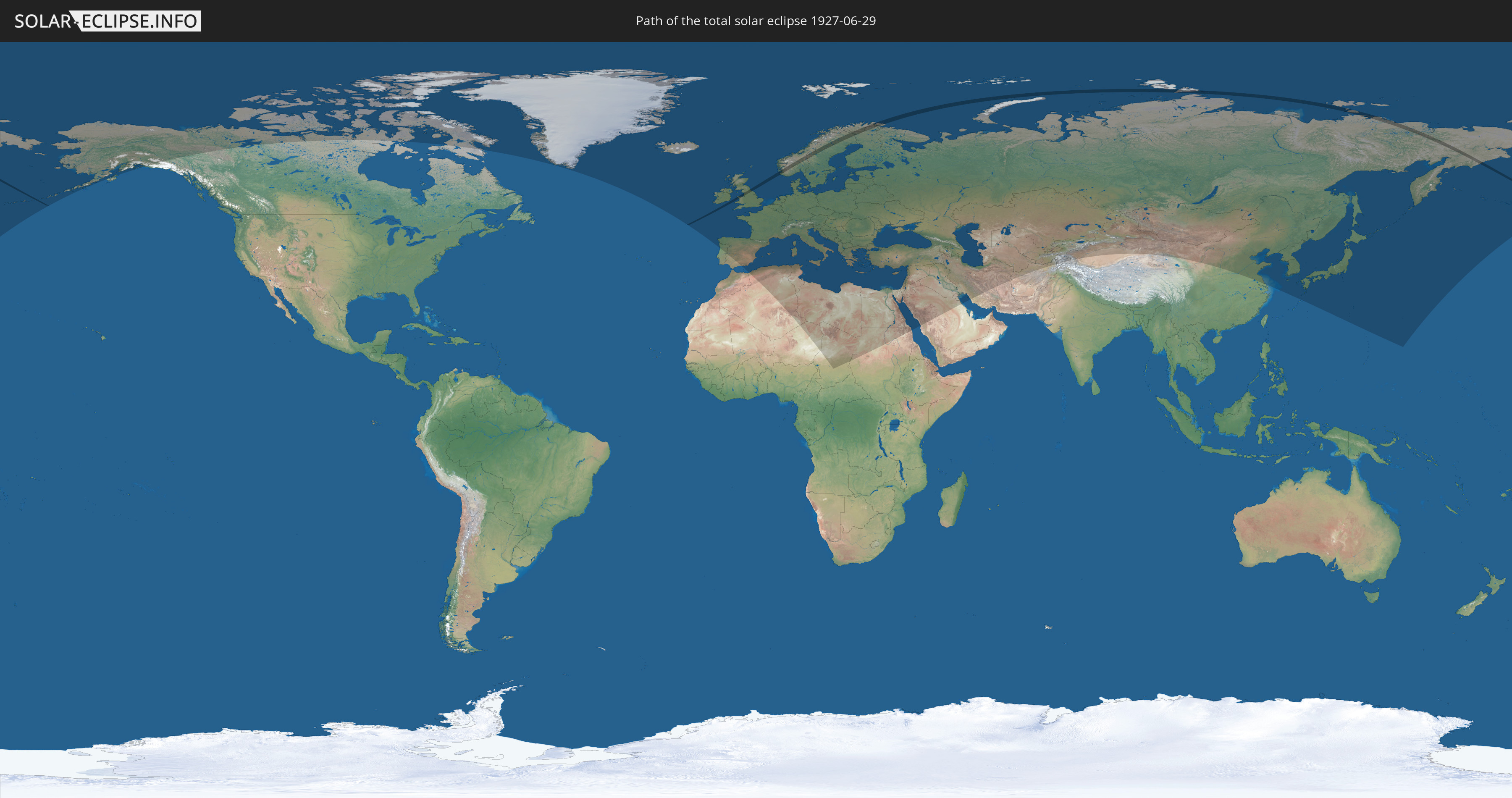
Die Sonnenfinsternis am 29.06.1927 kann man in 85 Ländern als partielle Sonnenfinsternis beobachten.
Der Finsternispfad verläuft durch 6 Länder. Nur in diesen Ländern ist sie als totale Sonnenfinsternis zu sehen.
In den folgenden Ländern ist die Sonnenfinsternis total zu sehen
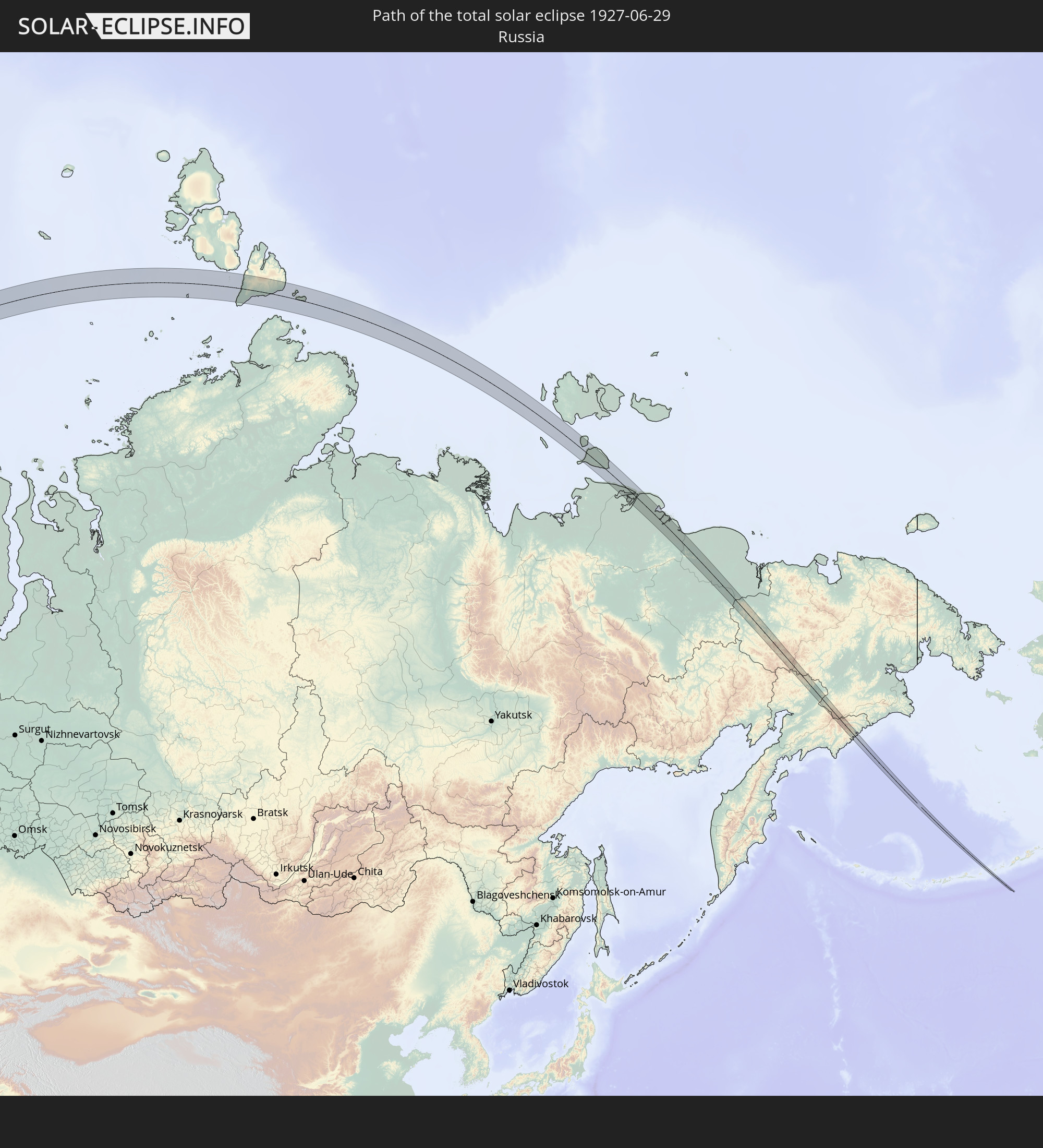 Russland
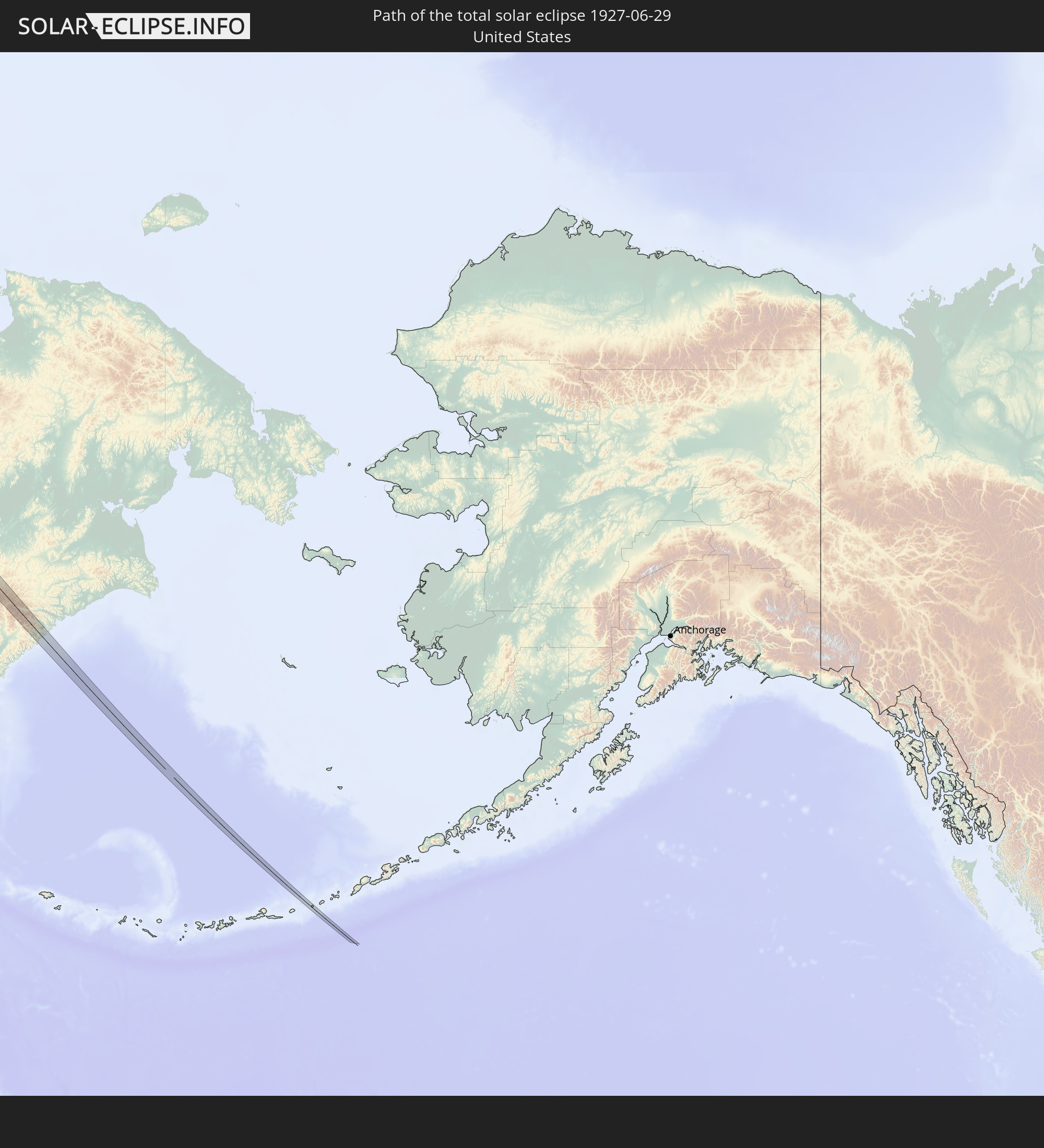 Vereinigte Staaten
 Vereinigtes Königreich
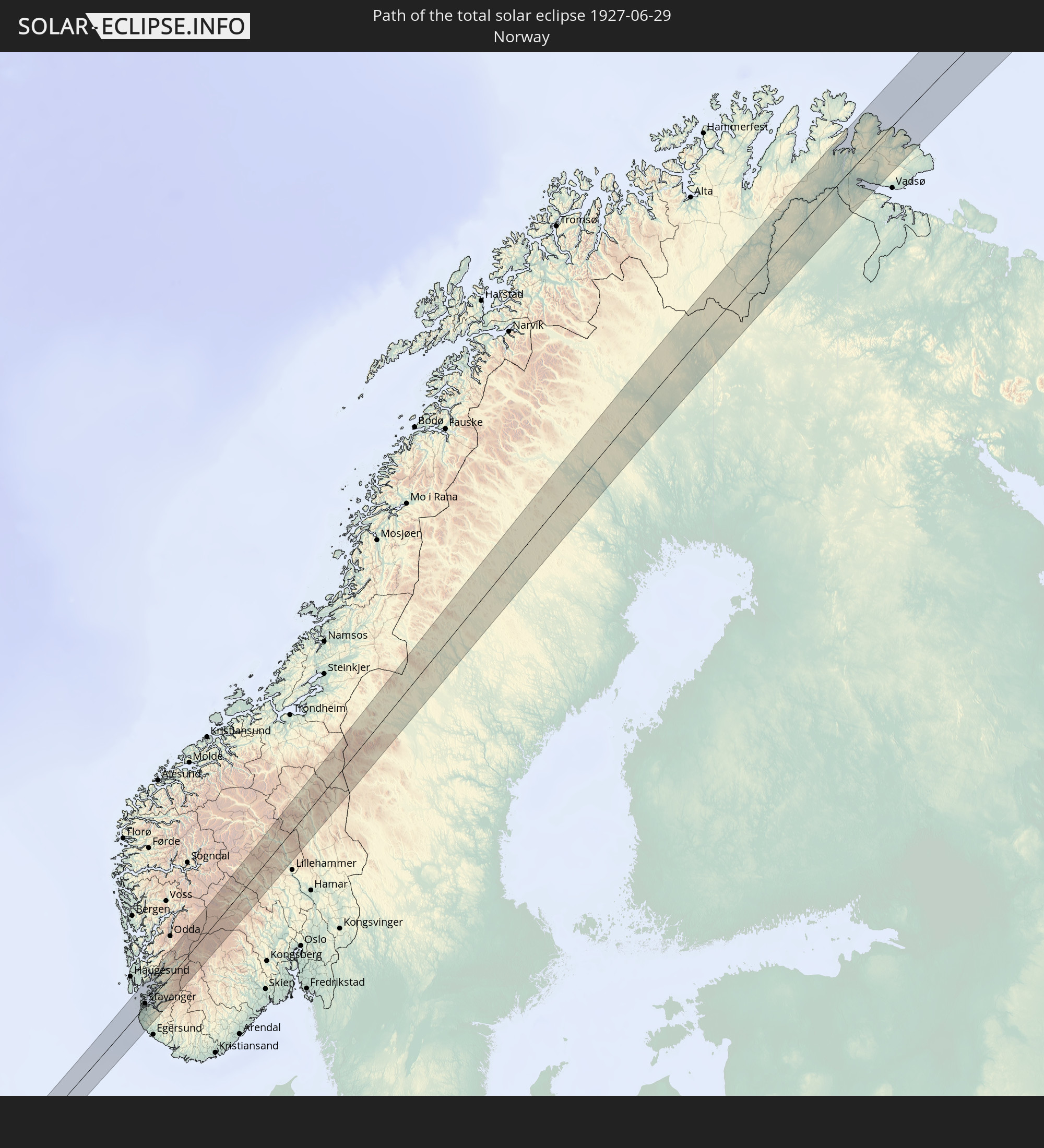 Norwegen
 Schweden
 Finnland
In den folgenden Ländern ist die Sonnenfinsternis partiell zu sehen
 Russland
 Vereinigte Staaten
 Kanada
 Grönland
 Portugal
 Island
 Spanien
 Irland
 Spitzbergen
 Algerien
 Vereinigtes Königreich
 Färöer
 Frankreich
 Isle of Man
 Guernsey
 Jersey
 Niger
Niger
 Andorra
 Belgien
 Niederlande
 Norwegen
 Luxemburg
 Deutschland
 Schweiz
 Italien
 Monaco
 Tunesien
 Dänemark
 Libyen
 Liechtenstein
 Österreich
 Schweden
 Tschechien
 San Marino
 Vatikanstadt
 Slowenien
 Tschad
 Kroatien
 Polen
Polen
 Malta
Malta
 Bosnien und Herzegowina
 Ungarn
 Slowakei
 Montenegro
 Serbien
 Albanien
 Åland Islands
 Griechenland
 Rumänien
 Mazedonien
 Finnland
 Litauen
 Lettland
 Estland
 Sudan
Sudan
 Ukraine
 Bulgarien
 Weißrussland
 Ägypten
 Türkei
 Moldawien
 Republik Zypern
 Staat Palästina
 Israel
 Saudi-Arabien
 Jordanien
 Libanon
 Syrien
 Irak
Irak
 Georgien
 Armenien
 Iran
Iran
 Aserbaidschan
 Kasachstan
 Kuwait
 Turkmenistan
 Usbekistan
 Afghanistan
 Tadschikistan
 Kirgisistan
 Volksrepublik China
 Mongolei
 Japan
Japan
 Nordkorea
 Südkorea
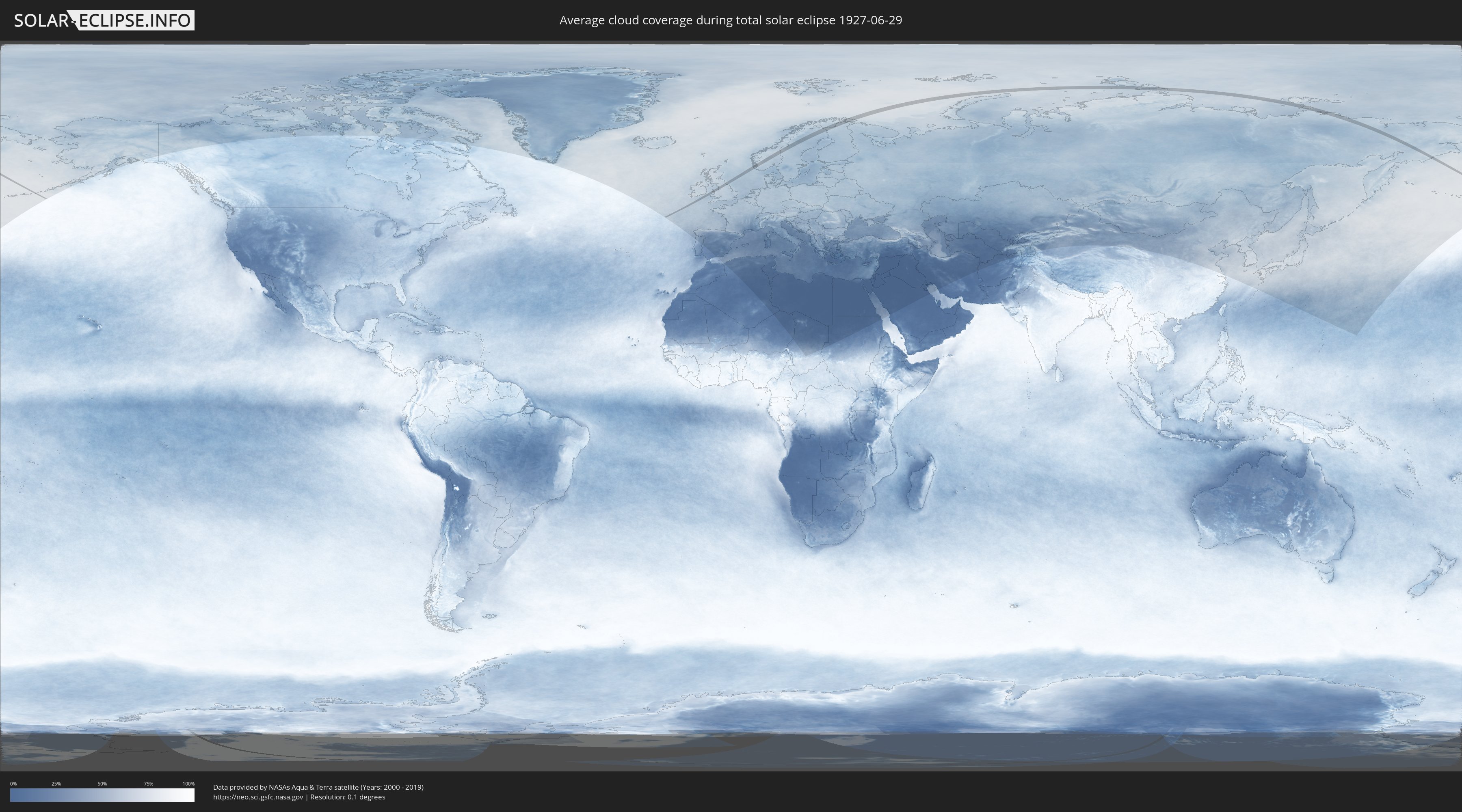
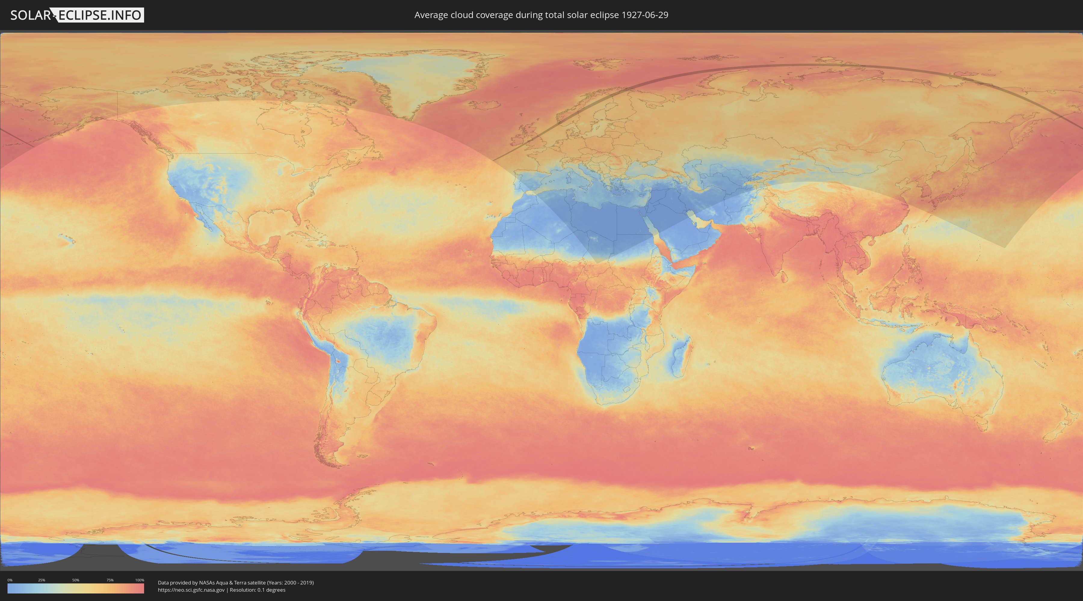
Wie wird das Wetter während der totalen Sonnenfinsternis am 29.06.1927?
Wo ist der beste Ort, um die totale Sonnenfinsternis vom 29.06.1927 zu beobachten?
Die folgenden Karten zeigen die durchschnittliche Bewölkung für den Tag, an dem die totale Sonnenfinsternis
stattfindet. Mit Hilfe der Karten lässt sich der Ort entlang des Finsternispfades eingrenzen,
der die besten Aussichen auf einen klaren wolkenfreien Himmel bietet.
Trotzdem muss man immer lokale Gegenenheiten beachten und sollte sich genau über das Wetter an seinem
gewählten Beobachtungsort informieren.
Die Daten stammen von den beiden NASA-Satelliten
AQUA und TERRA
und wurden über einen Zeitraum von 19 Jahren (2000 - 2019) gemittelt.
Detaillierte Länderkarten
 Russland
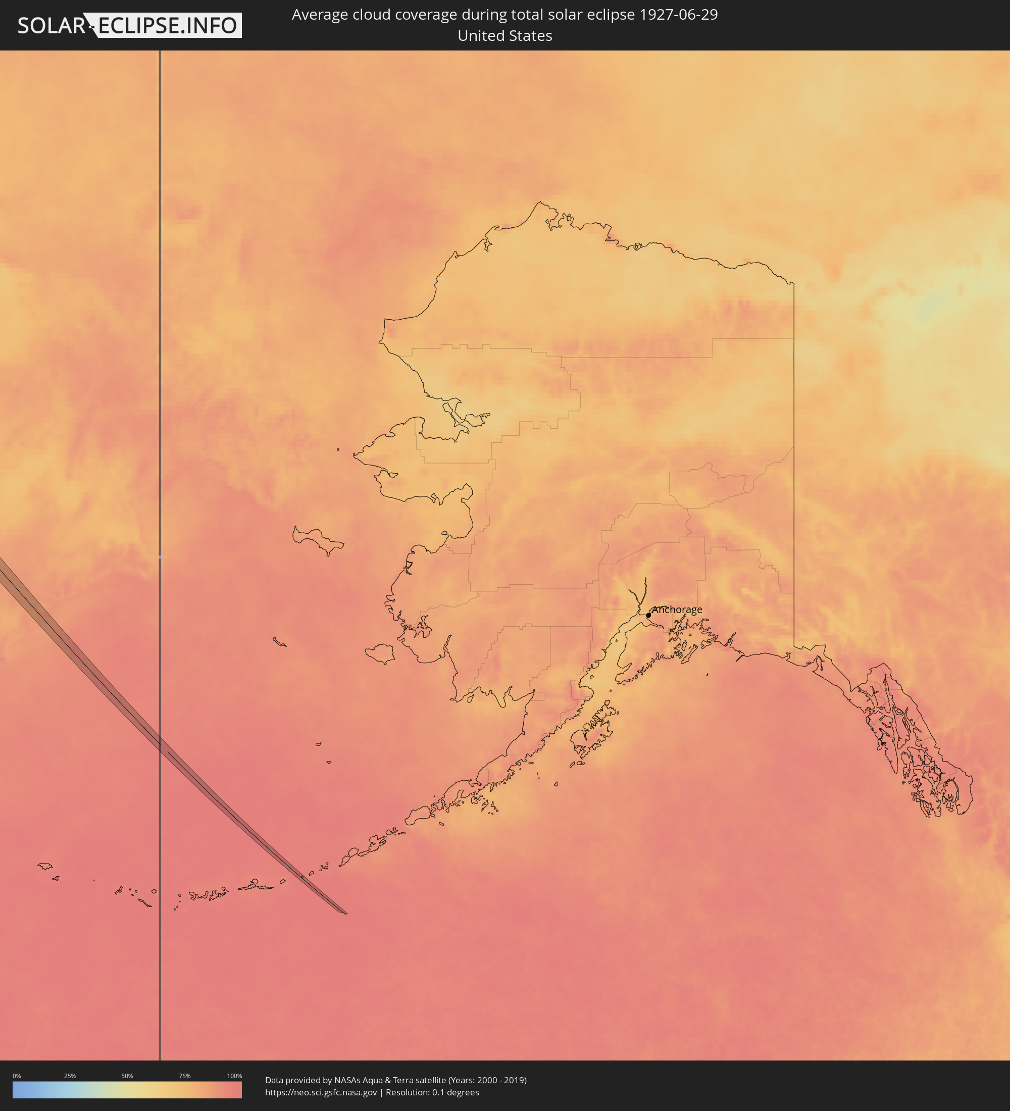 Vereinigte Staaten
 Vereinigtes Königreich
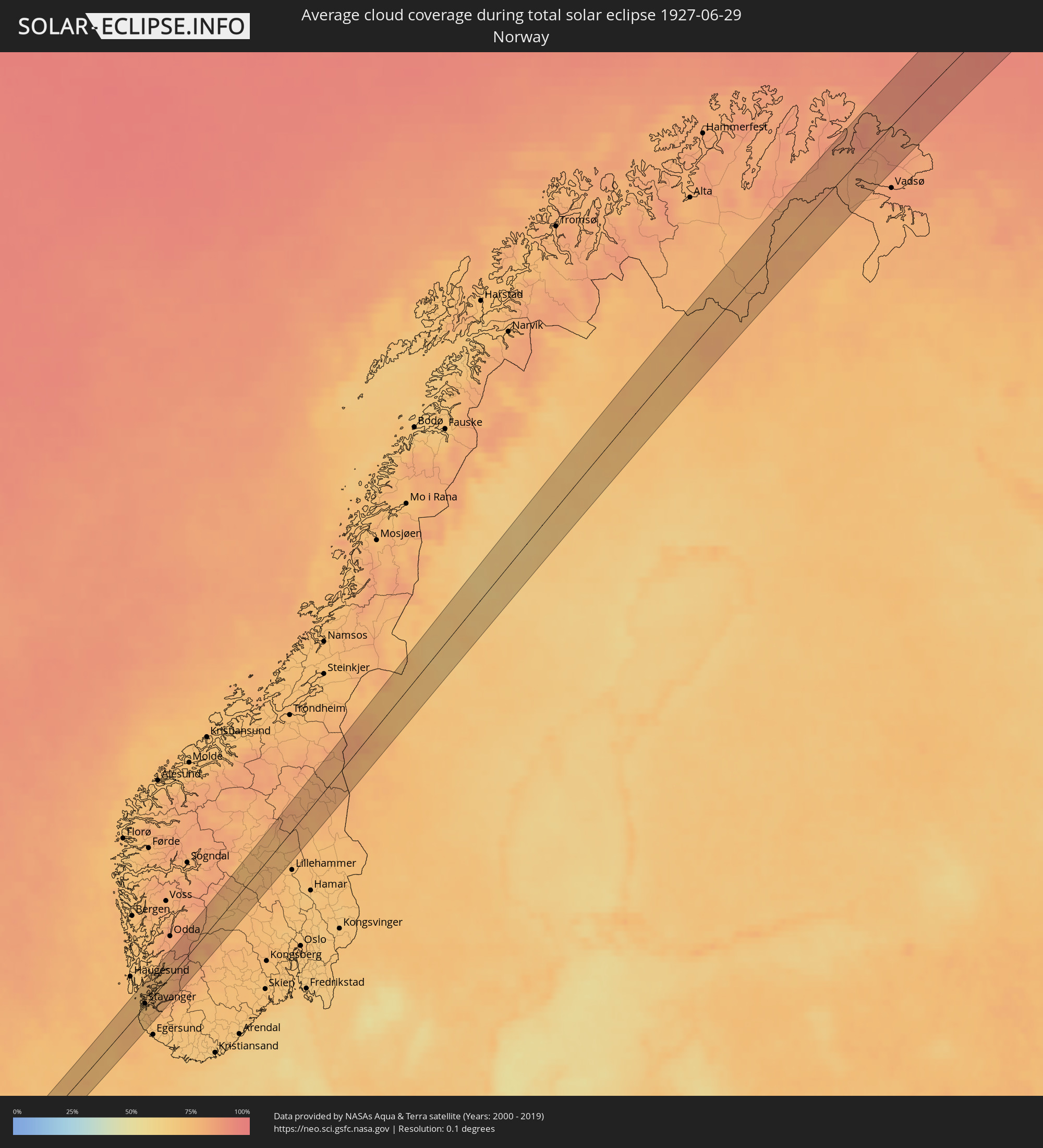 Norwegen
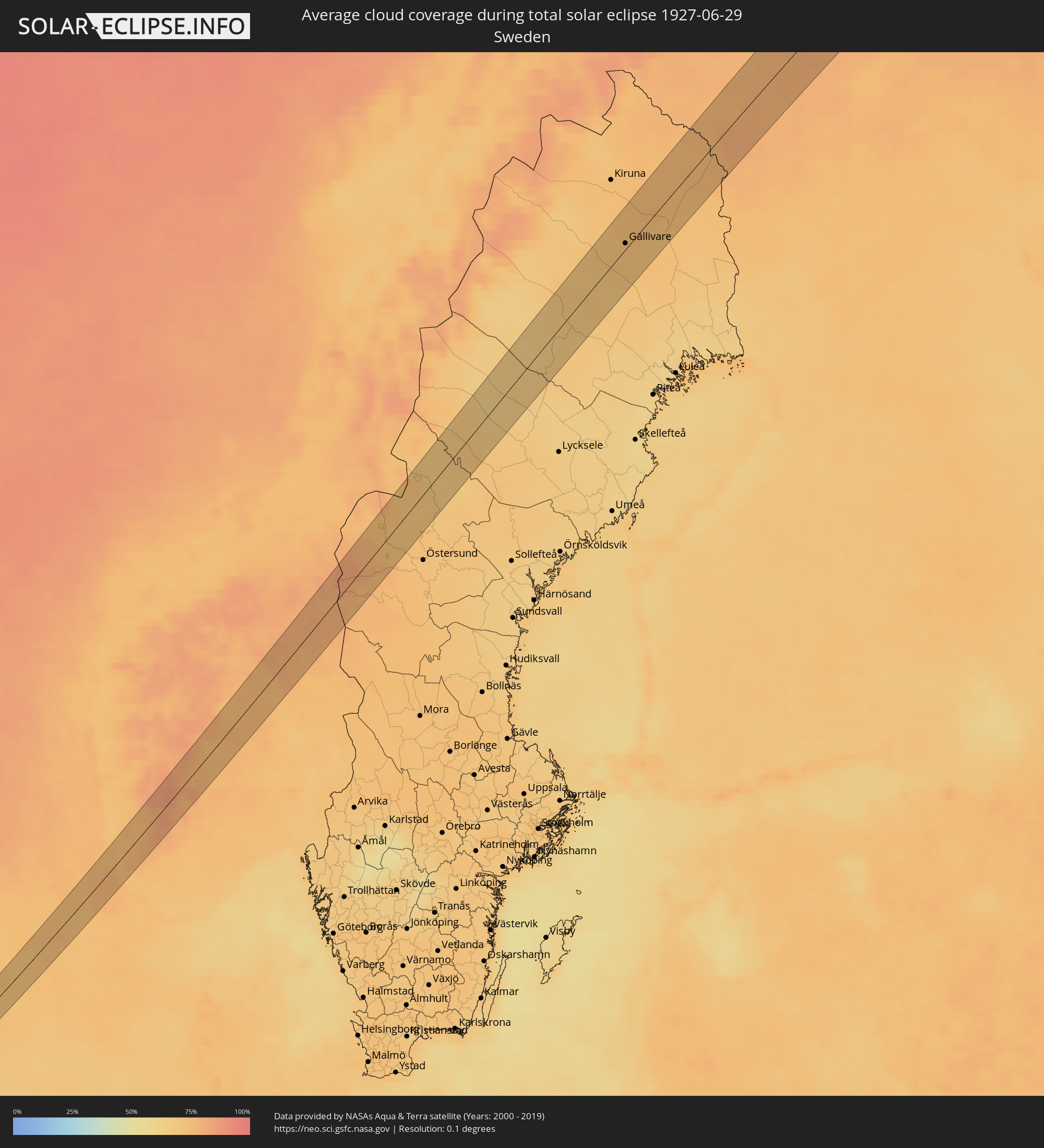 Schweden
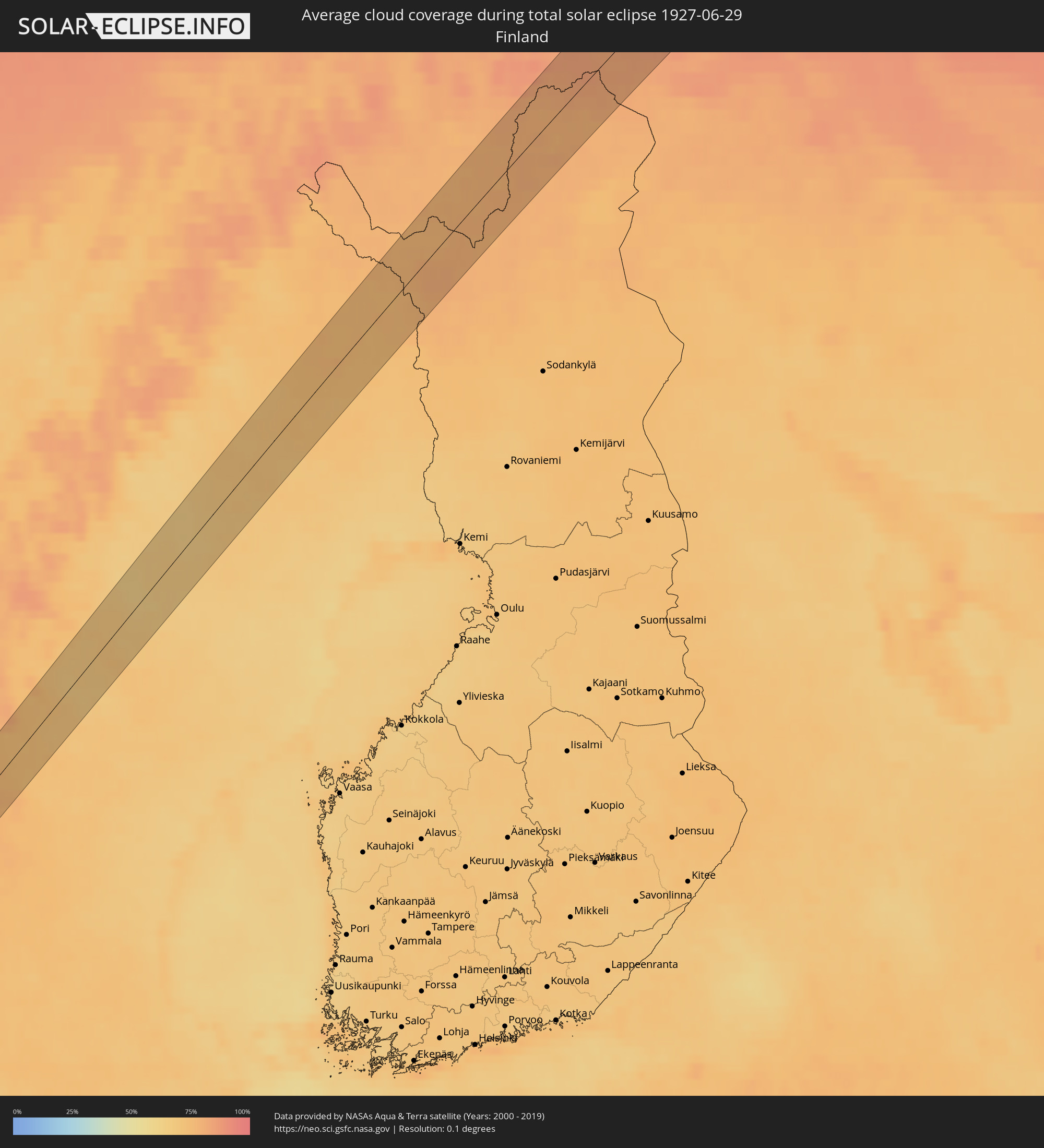 Finnland
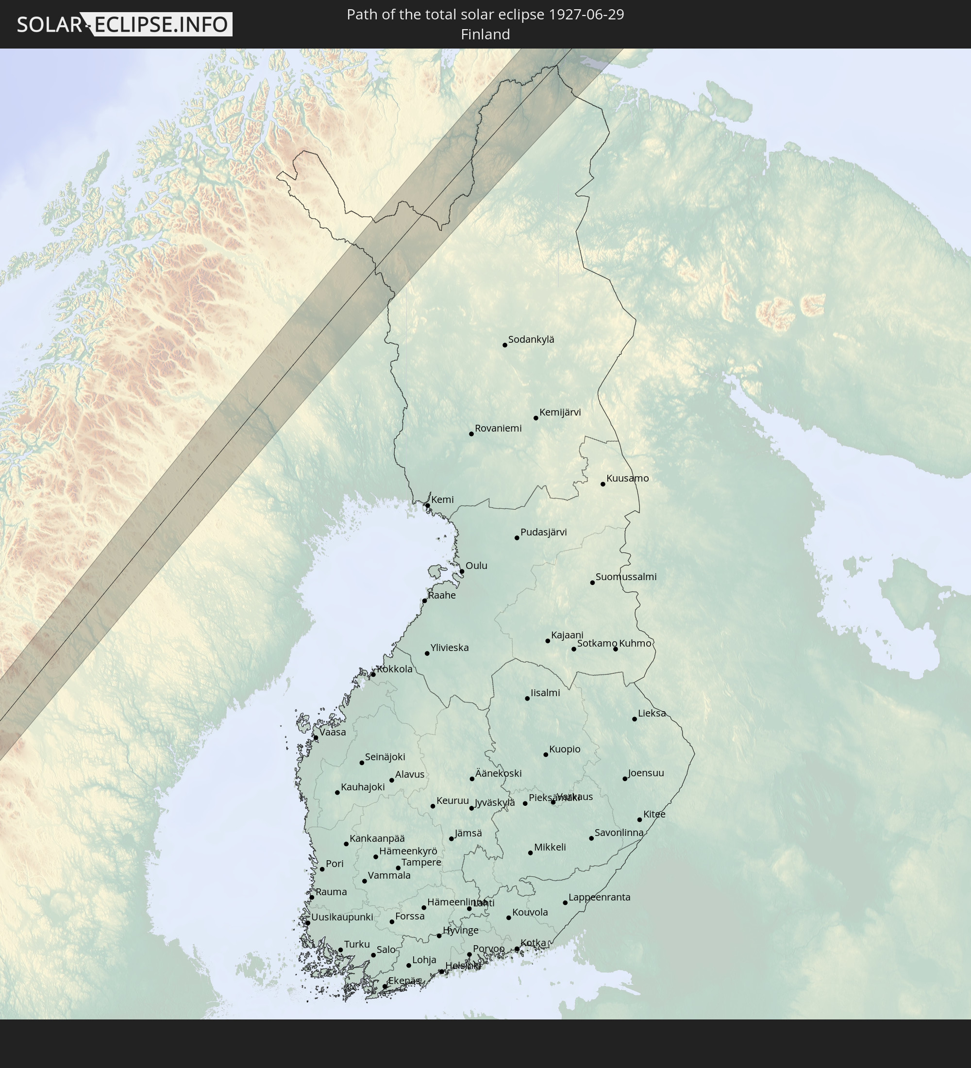
Orte im Finsternispfad
Die nachfolgene Tabelle zeigt Städte und Orte mit mehr als 5.000 Einwohnern, die sich im Finsternispfad befinden. Städte mit mehr als 100.000 Einwohnern sind dick gekennzeichnet. Mit einem Klick auf den Ort öffnet sich eine Detailkarte die die Lage des jeweiligen Ortes zusammen mit dem Verlauf der zentralen Finsternis präsentiert.
| Ort | Typ | Dauer der Verfinsterung | Ortszeit bei maximaler Verfinsterung | Entfernung zur Zentrallinie | Ø Bewölkung |
|
Caernarfon, Wales
|
total | - | 06:23:41 UTC+01:00 | 18 km | 80% |
|
Bangor, Wales
|
total | - | 06:23:46 UTC+01:00 | 16 km | 83% |
|
Llandudno, Wales
|
total | - | 06:23:49 UTC+01:00 | 24 km | 77% |
|
Deganwy, Wales
|
total | - | 06:23:47 UTC+01:00 | 24 km | 77% |
|
Colwyn Bay, Wales
|
total | - | 06:23:44 UTC+01:00 | 19 km | 77% |
|
Abergele, Wales
|
total | - | 06:23:41 UTC+01:00 | 14 km | 76% |
|
Rhyl, Wales
|
total | - | 06:23:42 UTC+01:00 | 9 km | 76% |
|
Denbigh, Wales
|
total | - | 06:23:29 UTC+01:00 | 25 km | 78% |
|
Prestatyn, Wales
|
total | - | 06:23:42 UTC+01:00 | 10 km | 76% |
|
Holywell, Wales
|
total | - | 06:23:33 UTC+01:00 | 23 km | 77% |
|
West Kirby, England
|
total | - | 06:23:41 UTC+01:00 | 21 km | 80% |
|
Moreton, England
|
total | - | 06:23:43 UTC+01:00 | 25 km | 79% |
|
Formby, England
|
total | - | 06:23:56 UTC+01:00 | 16 km | 76% |
|
Prenton, England
|
total | - | 06:23:39 UTC+01:00 | 30 km | 79% |
|
Blackpool, England
|
total | - | 06:24:19 UTC+01:00 | 14 km | 76% |
|
Cleveleys, England
|
total | - | 06:24:24 UTC+01:00 | 20 km | 77% |
|
Thornton-Cleveleys, England
|
total | - | 06:24:24 UTC+01:00 | 20 km | 77% |
|
Birkenhead, England
|
total | - | 06:23:40 UTC+01:00 | 32 km | 81% |
|
Fleetwood, England
|
total | - | 06:24:28 UTC+01:00 | 26 km | 77% |
|
Southport, England
|
total | - | 06:24:03 UTC+01:00 | 6 km | 78% |
|
Litherland, England
|
total | - | 06:23:47 UTC+01:00 | 25 km | 82% |
|
Poulton le Fylde, England
|
total | - | 06:24:19 UTC+01:00 | 15 km | 78% |
|
Maghull, England
|
total | - | 06:23:50 UTC+01:00 | 20 km | 82% |
|
Ormskirk, England
|
total | - | 06:23:53 UTC+01:00 | 16 km | 78% |
|
Kirkham, England
|
total | - | 06:24:13 UTC+01:00 | 13 km | 78% |
|
Freckleton, England
|
total | - | 06:24:10 UTC+01:00 | 11 km | 78% |
|
Morecambe, England
|
total | - | 06:24:39 UTC+01:00 | 25 km | 79% |
|
Tarleton, England
|
total | - | 06:24:03 UTC+01:00 | 11 km | 79% |
|
Bolton le Sands, England
|
total | - | 06:24:39 UTC+01:00 | 21 km | 79% |
|
Skelmersdale, England
|
total | - | 06:23:50 UTC+01:00 | 22 km | 80% |
|
Preston, England
|
total | - | 06:24:08 UTC+01:00 | 21 km | 80% |
|
Leyland, England
|
total | - | 06:24:02 UTC+01:00 | 21 km | 80% |
|
Euxton, England
|
total | - | 06:23:59 UTC+01:00 | 22 km | 80% |
|
Clayton-le-Woods, England
|
total | - | 06:24:02 UTC+01:00 | 22 km | 80% |
|
Coppull, England
|
total | - | 06:23:55 UTC+01:00 | 24 km | 81% |
|
Chorley, England
|
total | - | 06:23:56 UTC+01:00 | 26 km | 81% |
|
Longridge, England
|
total | - | 06:24:13 UTC+01:00 | 19 km | 80% |
|
Rishton, England
|
total | - | 06:24:04 UTC+01:00 | 25 km | 81% |
|
Great Harwood, England
|
total | - | 06:24:05 UTC+01:00 | 24 km | 81% |
|
Clitheroe, England
|
total | - | 06:24:12 UTC+01:00 | 15 km | 80% |
|
Clayton le Moors, England
|
total | - | 06:24:03 UTC+01:00 | 26 km | 81% |
|
Padiham, England
|
total | - | 06:24:05 UTC+01:00 | 24 km | 81% |
|
Barnoldswick, England
|
total | - | 06:24:14 UTC+01:00 | 22 km | 81% |
|
Barnard Castle, England
|
total | - | 06:25:06 UTC+01:00 | 27 km | 78% |
|
Crook, England
|
total | - | 06:25:18 UTC+01:00 | 20 km | 80% |
|
Catterick Garrison, England
|
total | - | 06:24:48 UTC+01:00 | 6 km | 79% |
|
Bishop Auckland, England
|
total | - | 06:25:13 UTC+01:00 | 14 km | 80% |
|
Shildon, England
|
total | - | 06:25:10 UTC+01:00 | 11 km | 81% |
|
Spennymoor, England
|
total | - | 06:25:16 UTC+01:00 | 14 km | 80% |
|
Durham, England
|
total | - | 06:25:23 UTC+01:00 | 22 km | 81% |
|
Chester-le-Street, England
|
total | - | 06:25:31 UTC+01:00 | 31 km | 81% |
|
Newton Aycliffe, England
|
total | - | 06:25:08 UTC+01:00 | 6 km | 81% |
|
Darlington, England
|
total | - | 06:24:59 UTC+01:00 | 7 km | 79% |
|
Ferryhill, England
|
total | - | 06:25:14 UTC+01:00 | 12 km | 80% |
|
Hetton-Le-Hole, England
|
total | - | 06:25:25 UTC+01:00 | 26 km | 80% |
|
Northallerton, England
|
total | - | 06:24:40 UTC+01:00 | 28 km | 80% |
|
Sunderland, England
|
total | - | 06:25:32 UTC+01:00 | 19 km | 80% |
|
Ryhope, England
|
total | - | 06:25:29 UTC+01:00 | 16 km | 80% |
|
Eaglescliffe, England
|
total | - | 06:24:56 UTC+01:00 | 12 km | 80% |
|
Seaham, England
|
total | - | 06:25:25 UTC+01:00 | 13 km | 80% |
|
Peterlee, England
|
total | - | 06:25:18 UTC+01:00 | 22 km | 80% |
|
Thornaby-on-Tees, England
|
total | - | 06:24:56 UTC+01:00 | 14 km | 79% |
|
Billingham, England
|
total | - | 06:25:01 UTC+01:00 | 14 km | 82% |
|
Middlesbrough, England
|
total | - | 06:24:59 UTC+01:00 | 17 km | 82% |
|
Redcar, England
|
total | - | 06:25:00 UTC+01:00 | 29 km | 80% |
|
Guisborough, England
|
total | - | 06:24:53 UTC+01:00 | 29 km | 79% |
|
Marske-by-the-Sea, England
|
total | - | 06:24:57 UTC+01:00 | 31 km | 79% |
|
Tananger, Rogaland
|
total | - | 06:30:55 UTC+01:00 | 16 km | 71% |
|
Bryne, Rogaland
|
total | - | 06:30:34 UTC+01:00 | 11 km | 72% |
|
Stavanger, Rogaland
|
total | - | 06:30:57 UTC+01:00 | 21 km | 72% |
|
Sandnes, Rogaland
|
total | - | 06:30:45 UTC+01:00 | 15 km | 74% |
|
Hommersåk, Rogaland
|
total | - | 06:30:52 UTC+01:00 | 21 km | 76% |
|
Jørpeland, Rogaland
|
total | - | 06:31:01 UTC+01:00 | 8 km | 76% |
|
Gällivare, Norrbotten
|
total | - | 06:46:35 UTC+01:00 | 17 km | 72% |
|
Malmberget, Norrbotten
|
total | - | 06:46:39 UTC+01:00 | 16 km | 73% |