Totale Sonnenfinsternis vom 12.11.1966
2 Personen haben diese Sonnenfinsternis beobachtet.
| Wochentag: | Samstag |
| Maximale Dauer der Verfinsterung: | 01m57s |
| Maximale Breite des Finsternispfades: | 84 km |
| Saroszyklus: | 142 |
| Bedeckungsgrad: | 100% |
| Magnitude: | 1.0234 |
| Gamma: | -0.33 |
Wo kann man die Sonnenfinsternis vom 12.11.1966 sehen?
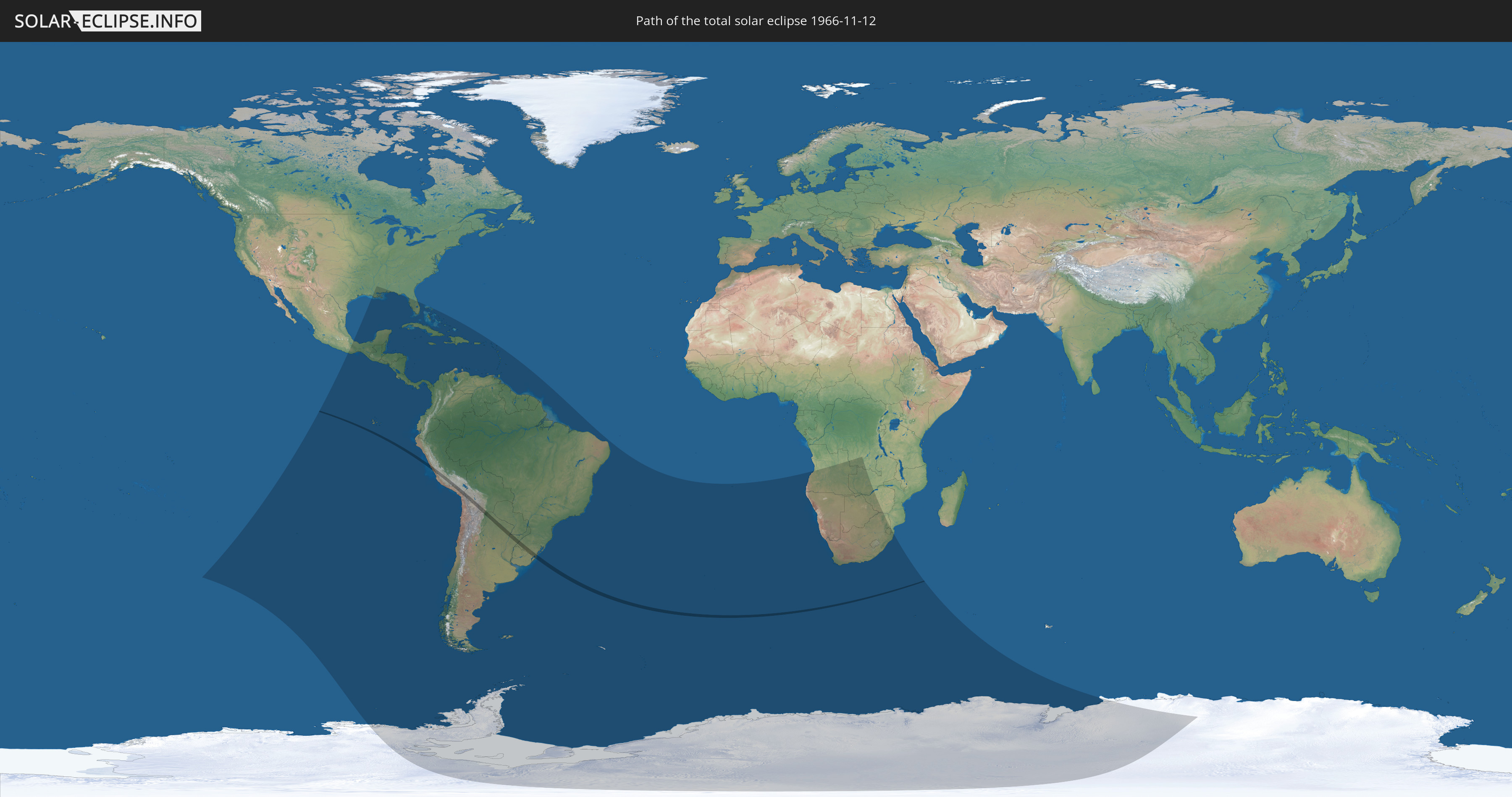
Die Sonnenfinsternis am 12.11.1966 kann man in 63 Ländern als partielle Sonnenfinsternis beobachten.
Der Finsternispfad verläuft durch 7 Länder. Nur in diesen Ländern ist sie als totale Sonnenfinsternis zu sehen.
In den folgenden Ländern ist die Sonnenfinsternis total zu sehen
 Chile
Chile
 Peru
Peru
 Brasilien
 Argentinien
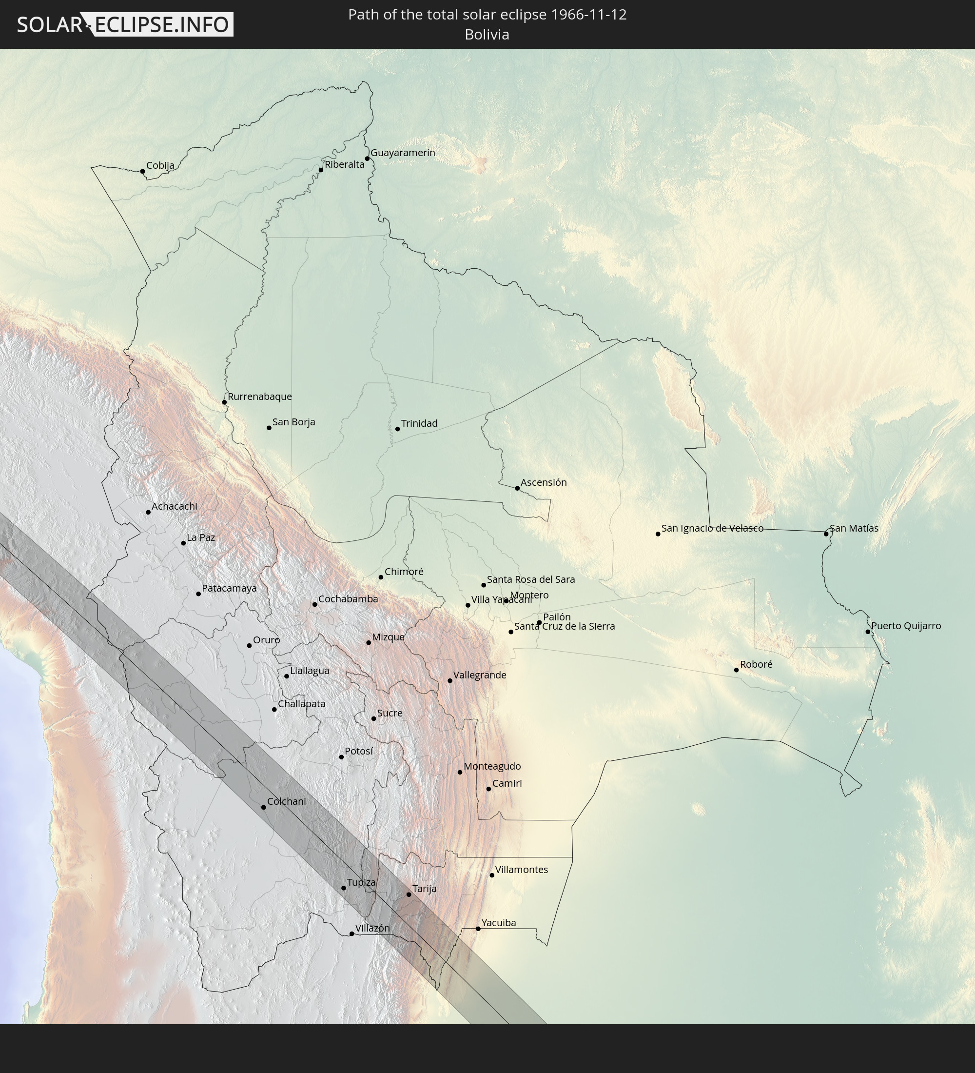 Bolivien
 Paraguay
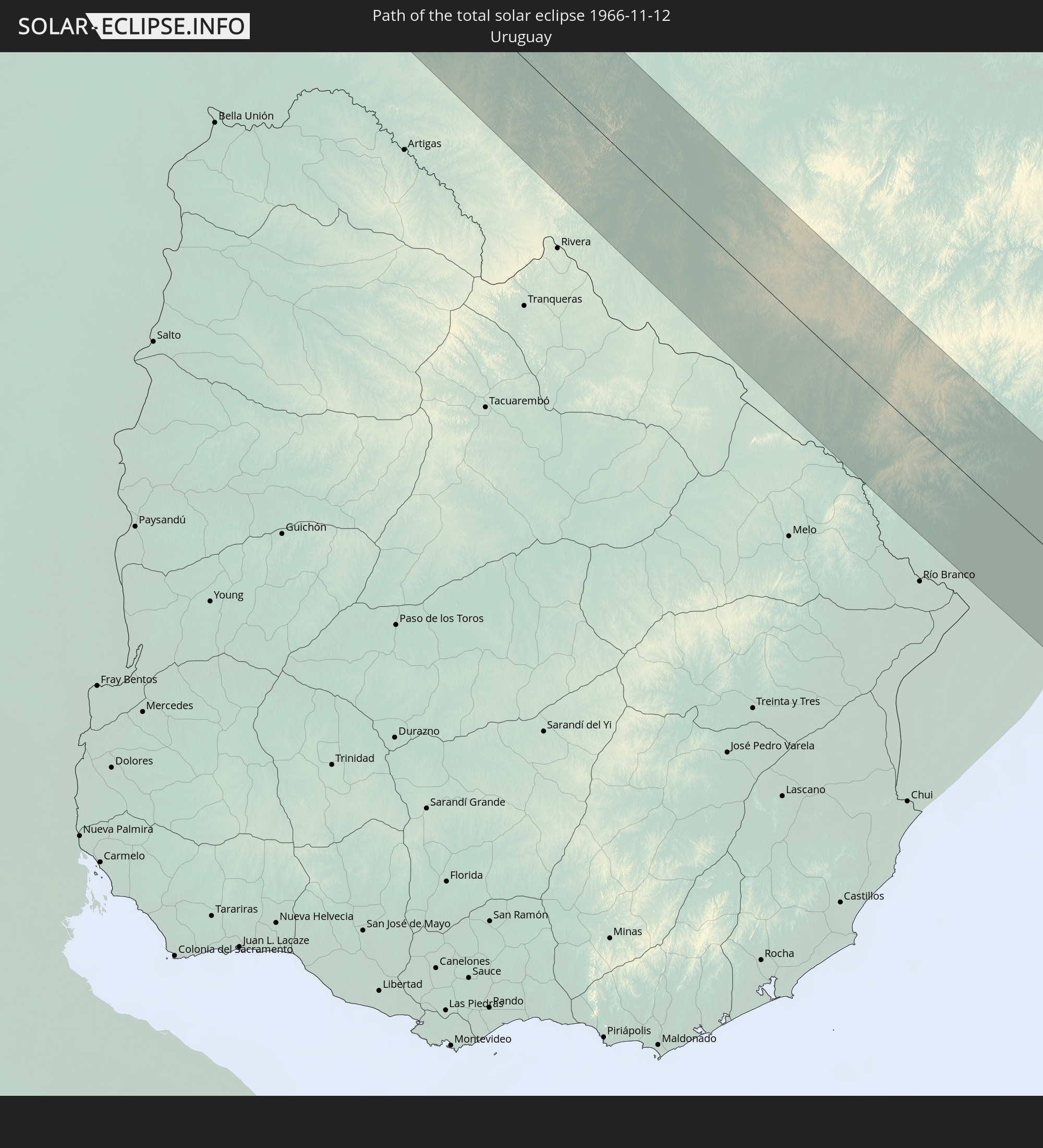 Uruguay
In den folgenden Ländern ist die Sonnenfinsternis partiell zu sehen
 Antarktika
 Vereinigte Staaten
 United States Minor Outlying Islands
 Mexiko
 Chile
Chile
 Guatemala
 Ecuador
 El Salvador
 Honduras
 Belize
 Nicaragua
 Costa Rica
 Kuba
Kuba
 Panama
 Kolumbien
 Kaimaninseln
 Peru
Peru
 Bahamas
 Jamaika
 Haiti
Haiti
 Brasilien
 Argentinien
 Venezuela
 Turks- und Caicosinseln
 Dominikanische Republik
 Aruba
Aruba
 Bolivien
 Puerto Rico
 Amerikanische Jungferninseln
 Britische Jungferninseln
 Anguilla
 Saint-Martin
 Saint-Barthélemy
 St. Kitts und Nevis
 Paraguay
 Antigua und Barbuda
 Montserrat
 Trinidad und Tobago
 Guadeloupe
 Grenada
 Dominica
 St. Vincent und die Grenadinen
 Falklandinseln
 Guyana
 Martinique
 St. Lucia
 Barbados
 Uruguay
 Suriname
 Französisch-Guayana
 Südgeorgien und die Südlichen Sandwichinseln
 St. Helena
 Bouvetinsel
 Angola
 Namibia
 Demokratische Republik Kongo
 Südafrika
 Botswana
 Sambia
 Simbabwe
 Lesotho
 Mosambik
 Swasiland
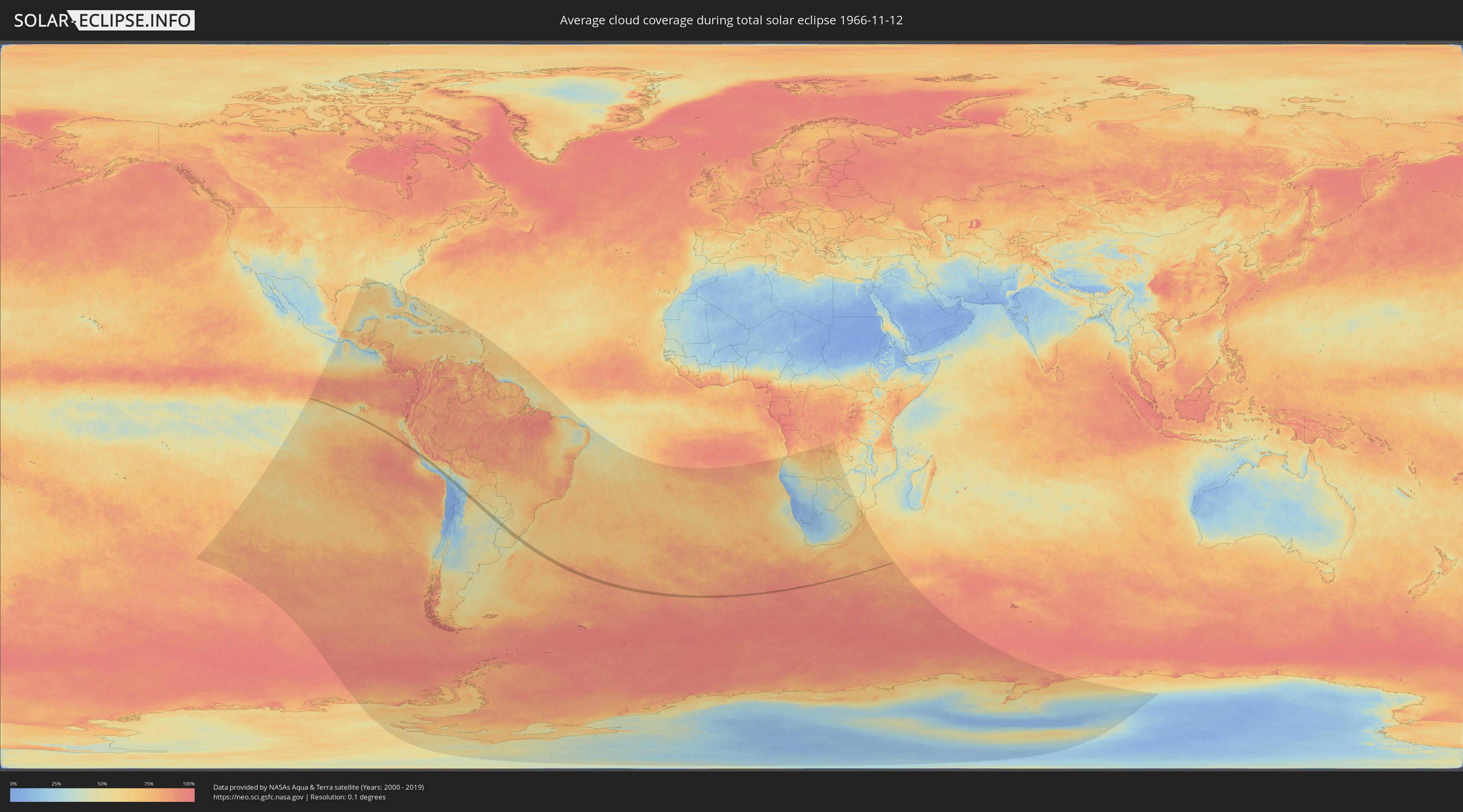
Wie wird das Wetter während der totalen Sonnenfinsternis am 12.11.1966?
Wo ist der beste Ort, um die totale Sonnenfinsternis vom 12.11.1966 zu beobachten?
Die folgenden Karten zeigen die durchschnittliche Bewölkung für den Tag, an dem die totale Sonnenfinsternis
stattfindet. Mit Hilfe der Karten lässt sich der Ort entlang des Finsternispfades eingrenzen,
der die besten Aussichen auf einen klaren wolkenfreien Himmel bietet.
Trotzdem muss man immer lokale Gegenenheiten beachten und sollte sich genau über das Wetter an seinem
gewählten Beobachtungsort informieren.
Die Daten stammen von den beiden NASA-Satelliten
AQUA und TERRA
und wurden über einen Zeitraum von 19 Jahren (2000 - 2019) gemittelt.

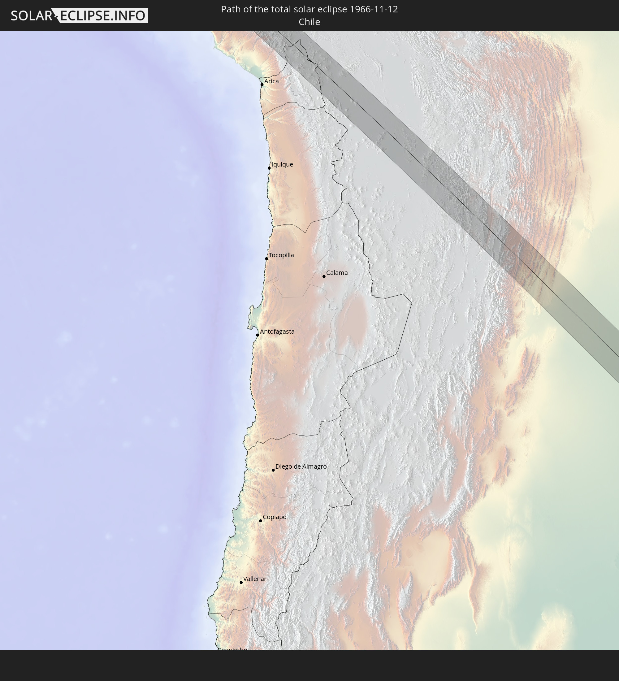
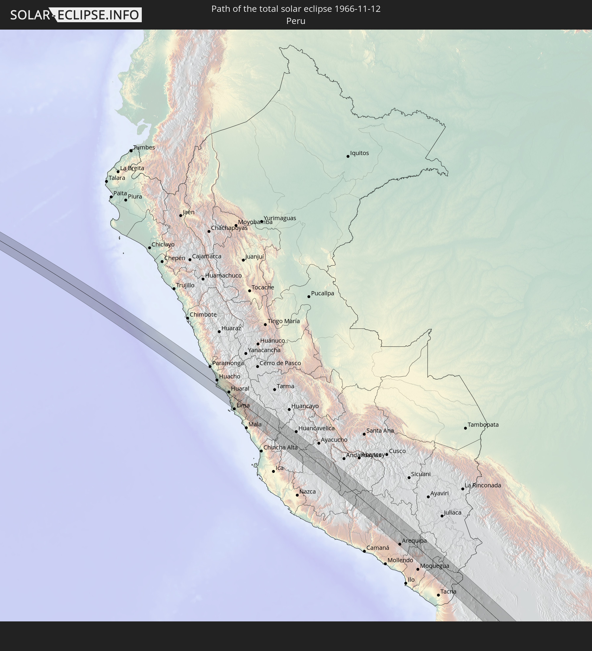
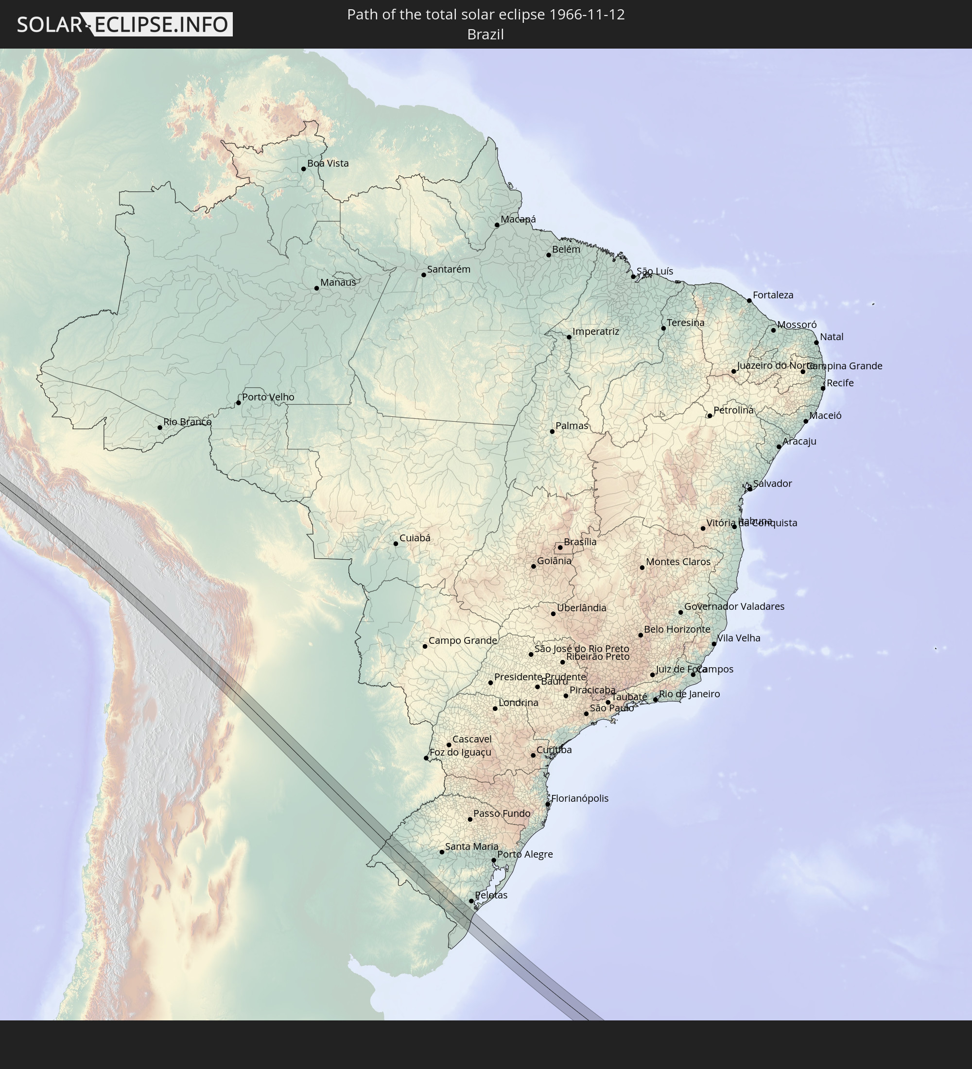
Detaillierte Länderkarten
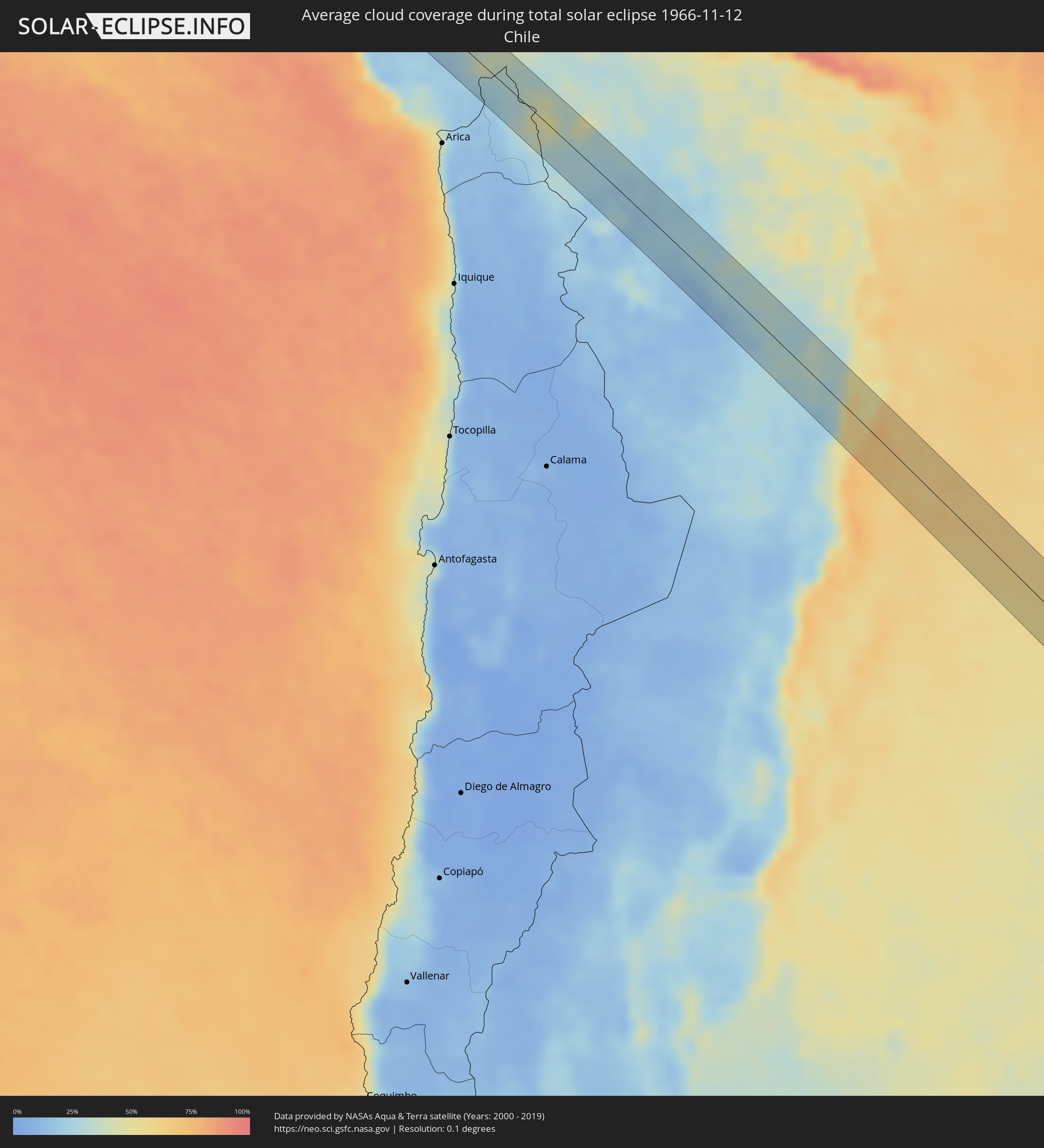 Chile
Chile
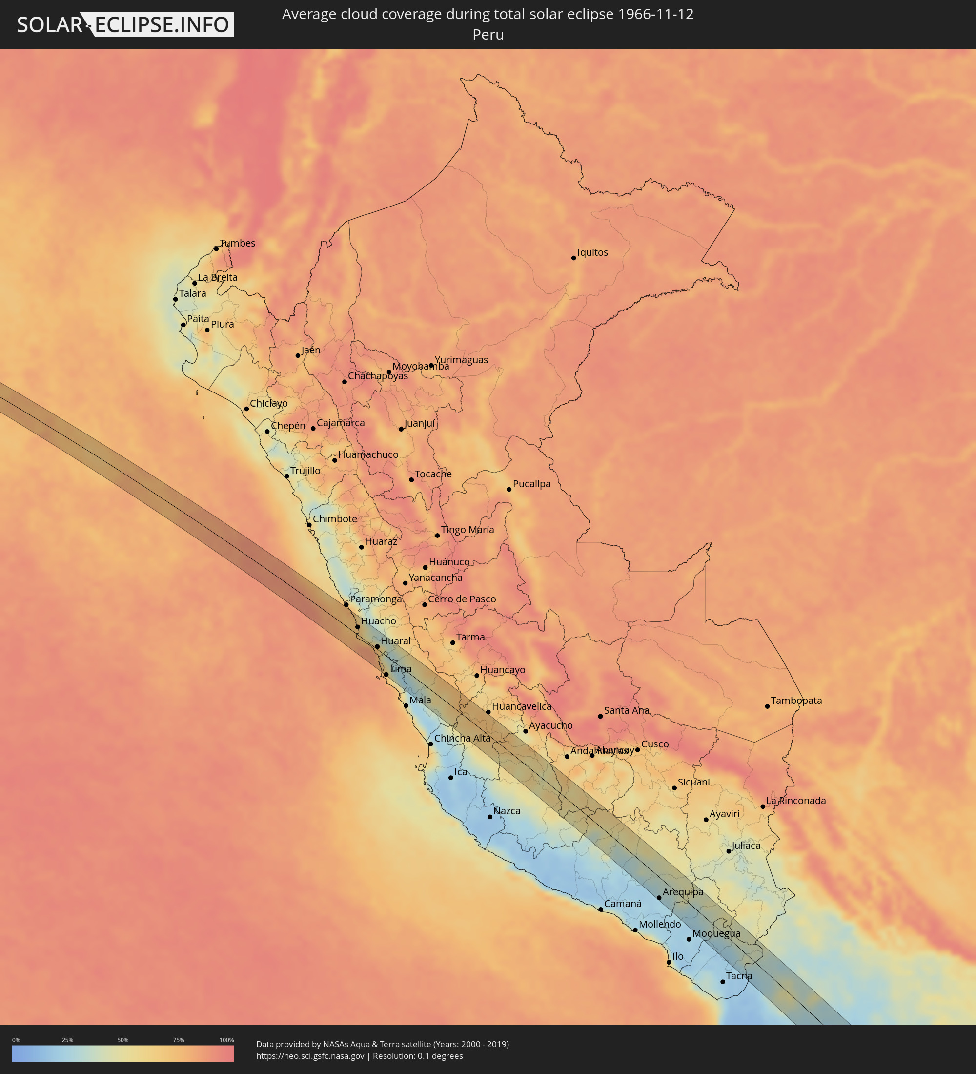 Peru
Peru
 Brasilien
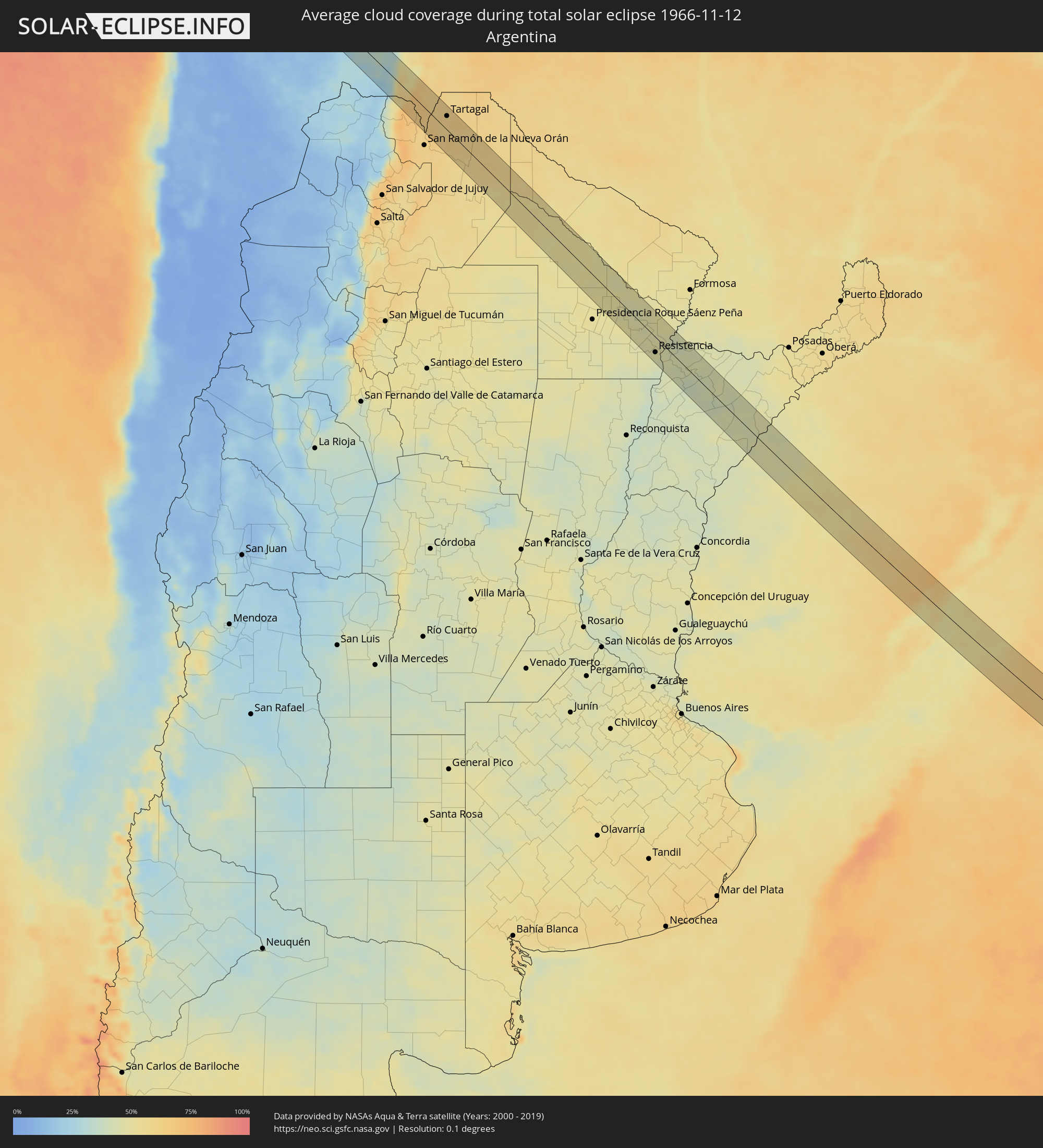 Argentinien
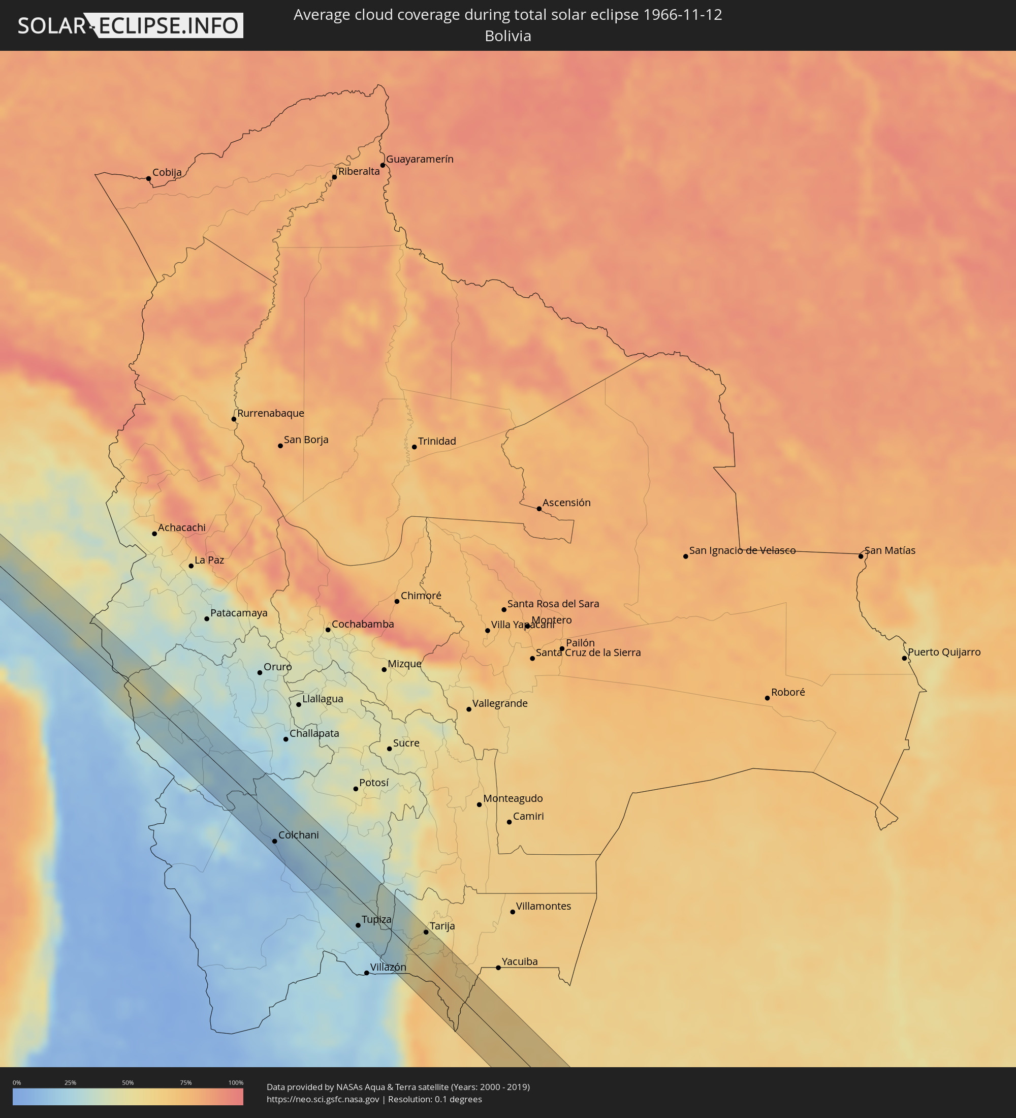 Bolivien
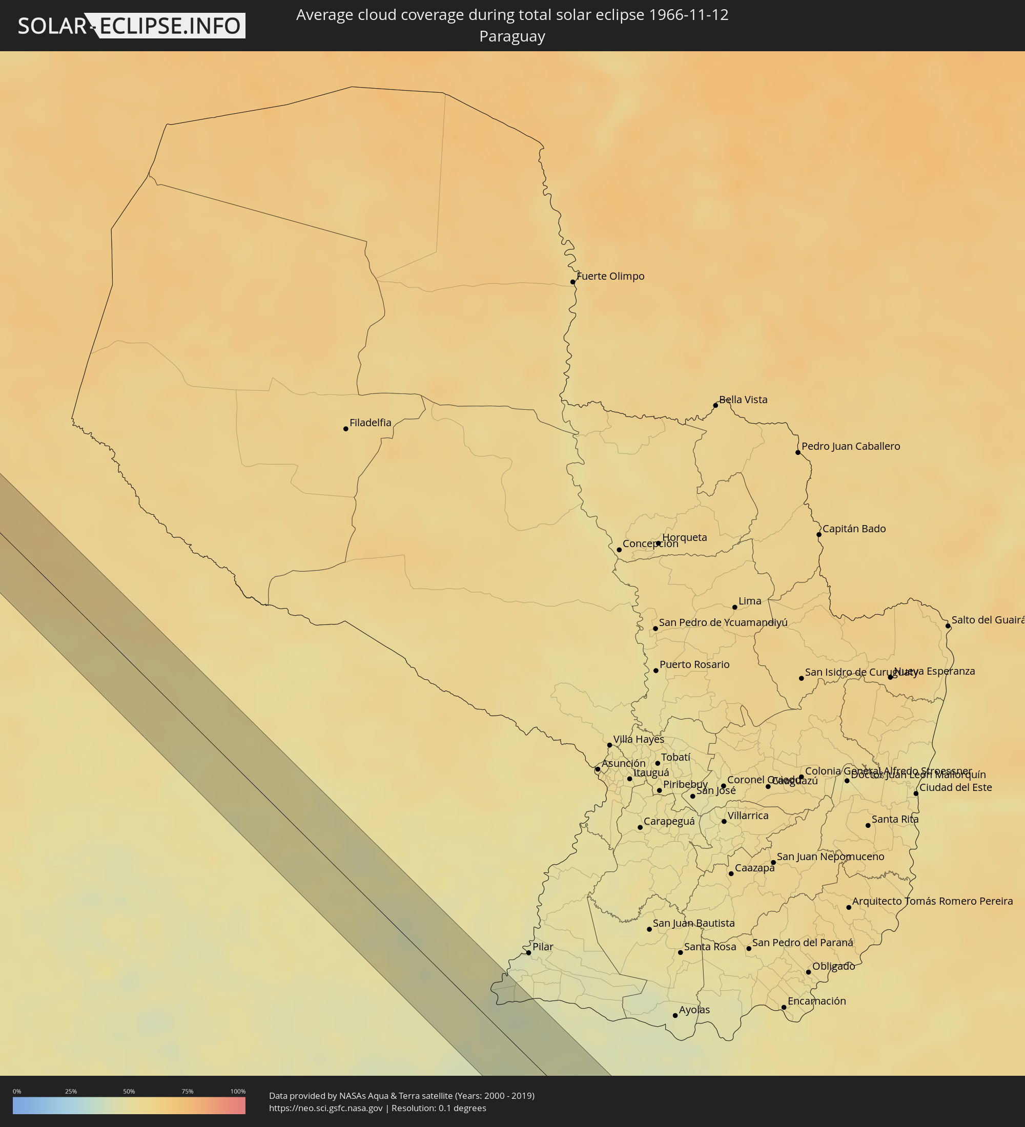 Paraguay
 Uruguay
Orte im Finsternispfad
Die nachfolgene Tabelle zeigt Städte und Orte mit mehr als 5.000 Einwohnern, die sich im Finsternispfad befinden. Städte mit mehr als 100.000 Einwohnern sind dick gekennzeichnet. Mit einem Klick auf den Ort öffnet sich eine Detailkarte die die Lage des jeweiligen Ortes zusammen mit dem Verlauf der zentralen Finsternis präsentiert.
| Ort | Typ | Dauer der Verfinsterung | Ortszeit bei maximaler Verfinsterung | Entfernung zur Zentrallinie | Ø Bewölkung |
|
Puerto Supe, Lima region
|
total | - | 08:00:46 UTC-05:00 | 32 km | 72% |
|
Végueta, Lima region
|
total | - | 08:01:09 UTC-05:00 | 18 km | 68% |
|
Caleta de Carquín, Lima region
|
total | - | 08:01:16 UTC-05:00 | 13 km | 69% |
|
Hualmay, Lima region
|
total | - | 08:01:17 UTC-05:00 | 14 km | 69% |
|
Huacho, Lima region
|
total | - | 08:01:18 UTC-05:00 | 13 km | 69% |
|
Huaura, Lima region
|
total | - | 08:01:15 UTC-05:00 | 17 km | 69% |
|
Chancay, Lima region
|
total | - | 08:02:12 UTC-05:00 | 6 km | 84% |
|
Huaral, Lima region
|
total | - | 08:02:08 UTC-05:00 | 4 km | 68% |
|
Lima, Lima Province
|
total | - | 08:03:05 UTC-05:00 | 33 km | 63% |
|
San Luis, Lima region
|
total | - | 08:03:09 UTC-05:00 | 33 km | 73% |
|
Santa María, Lima region
|
total | - | 08:03:06 UTC-05:00 | 20 km | 42% |
|
Chosica, Lima region
|
total | - | 08:03:08 UTC-05:00 | 3 km | 29% |
|
Asentamiento Humano Nicolas de Pierola, Lima region
|
total | - | 08:03:07 UTC-05:00 | 2 km | 29% |
|
Santa Eulalia, Lima region
|
total | - | 08:03:05 UTC-05:00 | 4 km | 29% |
|
Orcopampa, Arequipa
|
total | - | 08:11:45 UTC-05:00 | 5 km | 38% |
|
Lluta, Arequipa
|
total | - | 08:13:18 UTC-05:00 | 35 km | 20% |
|
Yura, Arequipa
|
total | - | 08:14:00 UTC-05:00 | 32 km | 22% |
|
Arequipa, Arequipa
|
total | - | 08:14:23 UTC-05:00 | 34 km | 25% |
|
Colchani, Potosí
|
total | - | 09:26:00 UTC-04:00 | 25 km | 12% |
|
Uyuni, Potosí
|
total | - | 09:26:25 UTC-04:00 | 31 km | 12% |
|
Tupiza, Potosí
|
total | - | 09:29:31 UTC-04:00 | 29 km | 28% |
|
Tarija, Tarija
|
total | - | 09:30:52 UTC-04:00 | 35 km | 50% |
|
General Enrique Mosconi, Salta Province
|
total | - | 10:34:01 UTC-03:00 | 16 km | 62% |
|
Tartagal, Salta Province
|
total | - | 10:33:53 UTC-03:00 | 23 km | 62% |
|
Castelli, Chaco Province
|
total | - | 10:44:45 UTC-03:00 | 20 km | 49% |
|
Tres Isletas, Chaco Province
|
total | - | 10:45:47 UTC-03:00 | 38 km | 49% |
|
Pampa del Indio, Chaco Province
|
total | - | 10:45:58 UTC-03:00 | 20 km | 49% |
|
El Colorado, Formosa Province
|
total | - | 10:47:13 UTC-03:00 | 39 km | 47% |
|
General José de San Martín, Chaco Province
|
total | - | 10:47:43 UTC-03:00 | 24 km | 46% |
|
Puerto Tirol, Chaco Province
|
total | - | 10:49:44 UTC-03:00 | 24 km | 46% |
|
Fontana, Chaco Province
|
total | - | 10:49:54 UTC-03:00 | 24 km | 47% |
|
Resistencia, Chaco Province
|
total | - | 10:50:02 UTC-03:00 | 24 km | 44% |
|
Margarita Belén, Chaco Province
|
total | - | 10:49:40 UTC-03:00 | 8 km | 47% |
|
Barranqueras, Chaco Province
|
total | - | 10:50:09 UTC-03:00 | 23 km | 43% |
|
Puerto Vilelas, Chaco Province
|
total | - | 10:50:13 UTC-03:00 | 26 km | 43% |
|
Corrientes, Corrientes Province
|
total | - | 10:50:18 UTC-03:00 | 16 km | 45% |
|
La Leonesa, Chaco Province
|
total | - | 10:49:38 UTC-03:00 | 29 km | 46% |
|
Paso de la Patria, Corrientes Province
|
total | - | 10:50:22 UTC-03:00 | 16 km | 43% |
|
San Luis del Palmar, Corrientes Province
|
total | - | 10:50:46 UTC-03:00 | 2 km | 45% |
|
Itatí, Corrientes Province
|
total | - | 10:50:46 UTC-03:00 | 42 km | 44% |
|
Mburucuyá, Corrientes Province
|
total | - | 10:52:18 UTC-03:00 | 18 km | 39% |
|
Santa Rosa, Corrientes Province
|
total | - | 10:52:53 UTC-03:00 | 28 km | 42% |
|
San Miguel, Corrientes Province
|
total | - | 10:53:10 UTC-03:00 | 30 km | 44% |
|
La Cruz, Corrientes Province
|
total | - | 10:56:54 UTC-03:00 | 1 km | 46% |
|
Itaqui, Rio Grande do Sul
|
total | - | 11:56:57 UTC-02:00 | 10 km | 46% |
|
Alvear, Corrientes Province
|
total | - | 10:56:53 UTC-03:00 | 13 km | 46% |
|
Alegrete, Rio Grande do Sul
|
total | - | 11:59:24 UTC-02:00 | 9 km | 47% |
|
Rosário do Sul, Rio Grande do Sul
|
total | - | 12:01:43 UTC-02:00 | 29 km | 55% |
|
Dom Pedrito, Rio Grande do Sul
|
total | - | 12:03:28 UTC-02:00 | 14 km | 54% |
|
Bagé, Rio Grande do Sul
|
total | - | 12:05:03 UTC-02:00 | 5 km | 61% |
|
Herval, Rio Grande do Sul
|
total | - | 12:07:31 UTC-02:00 | 16 km | 64% |
|
Pinheiro Machado, Rio Grande do Sul
|
total | - | 12:06:42 UTC-02:00 | 22 km | 62% |
|
Arroio Grande, Rio Grande do Sul
|
total | - | 12:08:25 UTC-02:00 | 13 km | 68% |