Totale Sonnenfinsternis vom 14.09.2099
| Wochentag: | Montag |
| Maximale Dauer der Verfinsterung: | 05m18s |
| Maximale Breite des Finsternispfades: | 241 km |
| Saroszyklus: | 136 |
| Bedeckungsgrad: | 100% |
| Magnitude: | 1.0684 |
| Gamma: | 0.3942 |
Wo kann man die Sonnenfinsternis vom 14.09.2099 sehen?
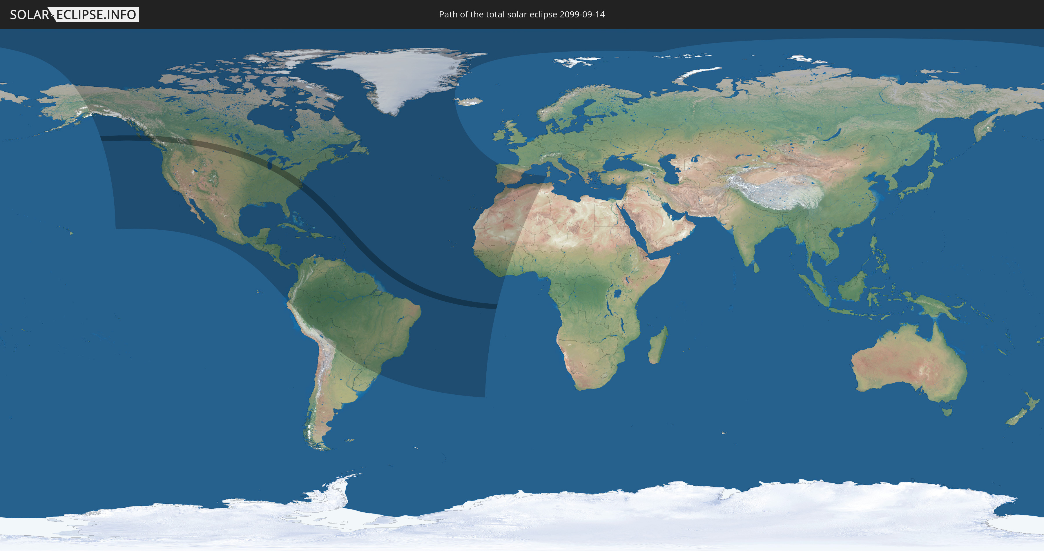
Die Sonnenfinsternis am 14.09.2099 kann man in 68 Ländern als partielle Sonnenfinsternis beobachten.
Der Finsternispfad verläuft durch 2 Länder. Nur in diesen Ländern ist sie als totale Sonnenfinsternis zu sehen.
In den folgenden Ländern ist die Sonnenfinsternis total zu sehen
 Vereinigte Staaten
 Kanada
In den folgenden Ländern ist die Sonnenfinsternis partiell zu sehen
 Vereinigte Staaten
 United States Minor Outlying Islands
 Kanada
 Mexiko
 Grönland
 Guatemala
 Ecuador
 El Salvador
 Honduras
 Belize
 Nicaragua
 Costa Rica
 Kuba
Kuba
 Panama
 Kolumbien
 Kaimaninseln
 Peru
Peru
 Bahamas
 Jamaika
 Haiti
Haiti
 Brasilien
 Argentinien
 Venezuela
 Turks- und Caicosinseln
 Dominikanische Republik
 Aruba
Aruba
 Bolivien
 Puerto Rico
 Amerikanische Jungferninseln
 Bermuda
 Britische Jungferninseln
 Anguilla
 Saint-Martin
 Saint-Barthélemy
 St. Kitts und Nevis
 Paraguay
 Antigua und Barbuda
 Montserrat
 Trinidad und Tobago
 Guadeloupe
 Grenada
 Dominica
 St. Vincent und die Grenadinen
 Guyana
 Martinique
 St. Lucia
 Barbados
 Suriname
 Saint-Pierre und Miquelon
 Französisch-Guayana
 Portugal
 Kap Verde
 Island
 Spanien
 Senegal
 Mauretanien
 Gambia
 Guinea-Bissau
 Guinea
 St. Helena
 Sierra Leone
 Marokko
 Mali
Mali
 Liberia
 Algerien
 Elfenbeinküste
 Burkina Faso
 Gibraltar
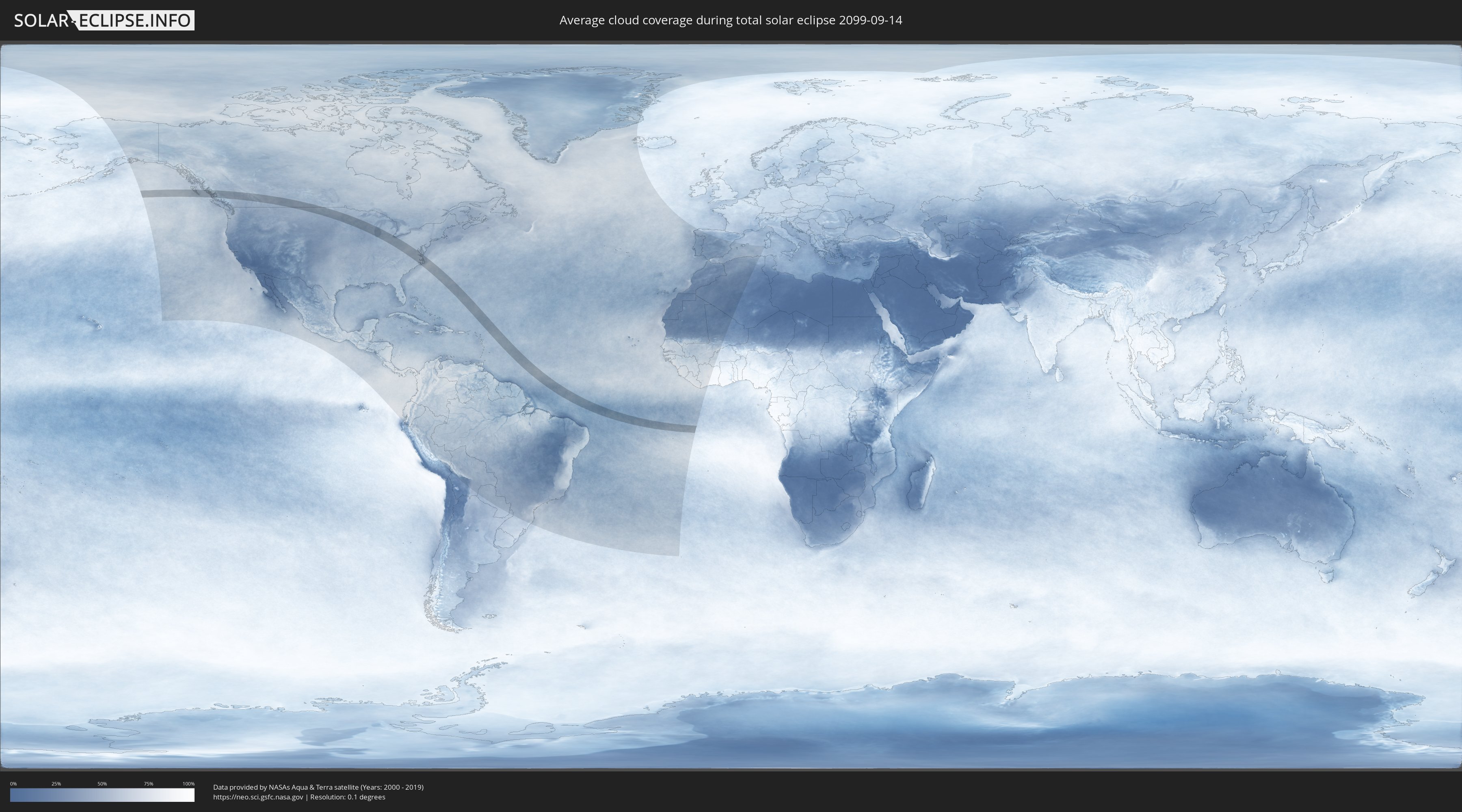
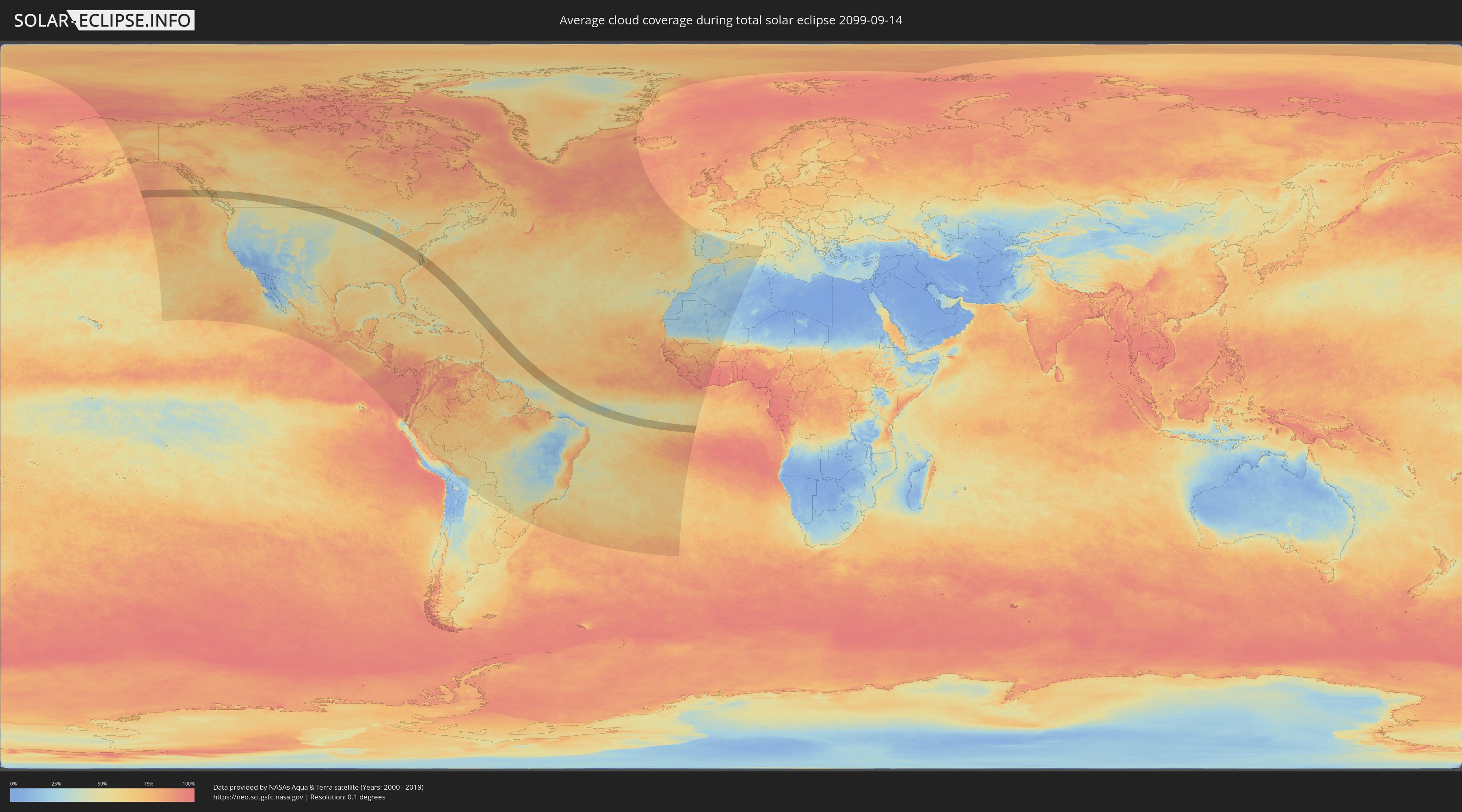
Wie wird das Wetter während der totalen Sonnenfinsternis am 14.09.2099?
Wo ist der beste Ort, um die totale Sonnenfinsternis vom 14.09.2099 zu beobachten?
Die folgenden Karten zeigen die durchschnittliche Bewölkung für den Tag, an dem die totale Sonnenfinsternis
stattfindet. Mit Hilfe der Karten lässt sich der Ort entlang des Finsternispfades eingrenzen,
der die besten Aussichen auf einen klaren wolkenfreien Himmel bietet.
Trotzdem muss man immer lokale Gegenenheiten beachten und sollte sich genau über das Wetter an seinem
gewählten Beobachtungsort informieren.
Die Daten stammen von den beiden NASA-Satelliten
AQUA und TERRA
und wurden über einen Zeitraum von 19 Jahren (2000 - 2019) gemittelt.
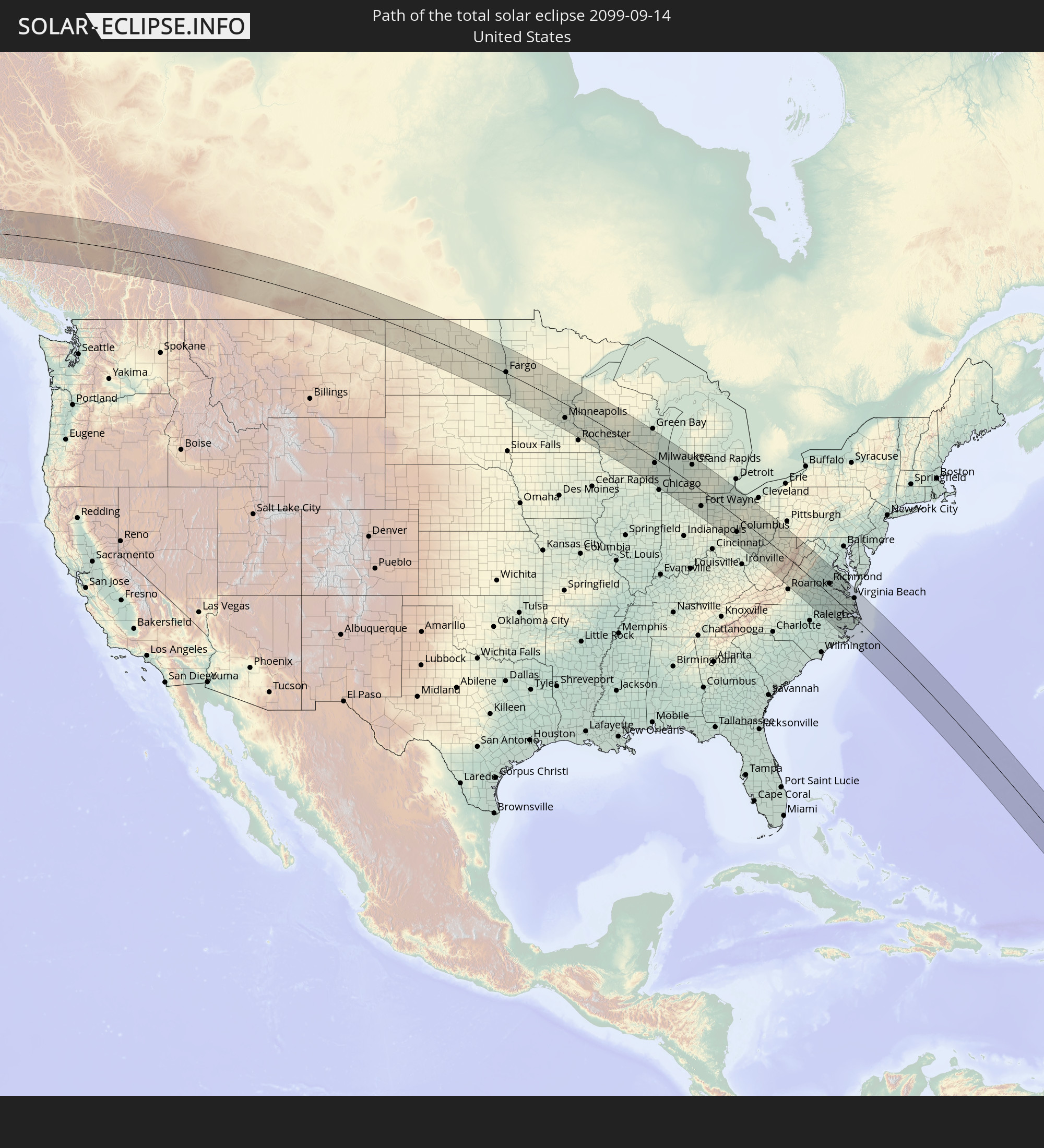
Detaillierte Länderkarten
 Vereinigte Staaten
 Kanada
Orte im Finsternispfad
Die nachfolgene Tabelle zeigt Städte und Orte mit mehr als 5.000 Einwohnern, die sich im Finsternispfad befinden. Städte mit mehr als 100.000 Einwohnern sind dick gekennzeichnet. Mit einem Klick auf den Ort öffnet sich eine Detailkarte die die Lage des jeweiligen Ortes zusammen mit dem Verlauf der zentralen Finsternis präsentiert.
| Ort | Typ | Dauer der Verfinsterung | Ortszeit bei maximaler Verfinsterung | Entfernung zur Zentrallinie | Ø Bewölkung |
|
Hanceville, British Columbia
|
total | - | 07:23:36 UTC-08:00 | 6 km | 57% |
|
Williams Lake, British Columbia
|
total | - | 07:24:05 UTC-08:00 | 27 km | 54% |
|
Revelstoke, British Columbia
|
total | - | 07:25:07 UTC-08:00 | 53 km | 53% |
|
Banff, Alberta
|
total | - | 08:26:32 UTC-07:00 | 3 km | 60% |
|
Canmore, Alberta
|
total | - | 08:26:36 UTC-07:00 | 4 km | 61% |
|
Cochrane, Alberta
|
total | - | 08:27:08 UTC-07:00 | 21 km | 54% |
|
Olds, Alberta
|
total | - | 08:27:37 UTC-07:00 | 92 km | 59% |
|
Calgary, Alberta
|
total | - | 08:27:17 UTC-07:00 | 13 km | 57% |
|
Airdrie, Alberta
|
total | - | 08:27:26 UTC-07:00 | 41 km | 60% |
|
Okotoks, Alberta
|
total | - | 08:27:11 UTC-07:00 | 20 km | 60% |
|
High River, Alberta
|
total | - | 08:27:11 UTC-07:00 | 34 km | 60% |
|
Strathmore, Alberta
|
total | - | 08:27:41 UTC-07:00 | 24 km | 57% |
|
Taber, Alberta
|
total | - | 08:27:53 UTC-07:00 | 90 km | 57% |
|
Brooks, Alberta
|
total | - | 08:28:22 UTC-07:00 | 1 km | 60% |
|
Medicine Hat, Alberta
|
total | - | 08:28:54 UTC-07:00 | 35 km | 53% |
|
Swift Current, Saskatchewan
|
total | - | 09:30:55 UTC-06:00 | 51 km | 55% |
|
Weyburn, Saskatchewan
|
total | - | 09:33:39 UTC-06:00 | 80 km | 56% |
|
Estevan, Saskatchewan
|
total | - | 09:34:15 UTC-06:00 | 47 km | 51% |
|
Minot, North Dakota
|
total | - | 09:35:32 UTC-06:00 | 1 km | 58% |
|
Grand Forks, North Dakota
|
total | - | 09:39:22 UTC-06:00 | 100 km | 60% |
|
Fargo, North Dakota
|
total | - | 09:39:40 UTC-06:00 | 3 km | 55% |
|
Saint Cloud, Minnesota
|
total | - | 09:42:31 UTC-06:00 | 34 km | 48% |
|
Elk River, Minnesota
|
total | - | 09:43:12 UTC-06:00 | 37 km | 49% |
|
Shakopee, Minnesota
|
total | - | 09:43:23 UTC-06:00 | 85 km | 45% |
|
Plymouth, Minnesota
|
total | - | 09:43:24 UTC-06:00 | 61 km | 47% |
|
West Coon Rapids, Minnesota
|
total | - | 09:43:29 UTC-06:00 | 43 km | 50% |
|
Bloomington, Minnesota
|
total | - | 09:43:37 UTC-06:00 | 72 km | 49% |
|
Minneapolis, Minnesota
|
total | - | 09:43:37 UTC-06:00 | 57 km | 49% |
|
Lakeville, Minnesota
|
total | - | 09:43:44 UTC-06:00 | 88 km | 50% |
|
White Bear Lake, Minnesota
|
total | - | 09:43:52 UTC-06:00 | 37 km | 46% |
|
Woodbury, Minnesota
|
total | - | 09:43:58 UTC-06:00 | 51 km | 47% |
|
Hastings, Minnesota
|
total | - | 09:44:08 UTC-06:00 | 64 km | 51% |
|
Winona, Minnesota
|
total | - | 09:45:42 UTC-06:00 | 83 km | 45% |
|
Eau Claire, Wisconsin
|
total | - | 09:45:36 UTC-06:00 | 4 km | 47% |
|
La Crosse, Wisconsin
|
total | - | 09:46:15 UTC-06:00 | 91 km | 42% |
|
Wausau, Wisconsin
|
total | - | 09:47:39 UTC-06:00 | 86 km | 51% |
|
Stevens Point, Wisconsin
|
total | - | 09:47:53 UTC-06:00 | 47 km | 48% |
|
Madison, Wisconsin
|
total | - | 09:48:43 UTC-06:00 | 82 km | 46% |
|
Sun Prairie, Wisconsin
|
total | - | 09:48:53 UTC-06:00 | 64 km | 52% |
|
Janesville, Wisconsin
|
total | - | 09:49:22 UTC-06:00 | 102 km | 51% |
|
Watertown, Wisconsin
|
total | - | 09:49:28 UTC-06:00 | 41 km | 51% |
|
Oshkosh, Wisconsin
|
total | - | 09:49:18 UTC-06:00 | 44 km | 46% |
|
Fond du Lac, Wisconsin
|
total | - | 09:49:32 UTC-06:00 | 26 km | 52% |
|
Appleton, Wisconsin
|
total | - | 09:49:20 UTC-06:00 | 72 km | 53% |
|
McHenry, Illinois
|
total | - | 09:50:28 UTC-06:00 | 101 km | 45% |
|
Waukesha, Wisconsin
|
total | - | 09:50:09 UTC-06:00 | 36 km | 53% |
|
West Bend, Wisconsin
|
total | - | 09:50:00 UTC-06:00 | 4 km | 52% |
|
Menomonee Falls, Wisconsin
|
total | - | 09:50:12 UTC-06:00 | 16 km | 55% |
|
Round Lake Beach, Illinois
|
total | - | 09:50:40 UTC-06:00 | 90 km | 48% |
|
De Pere, Wisconsin
|
total | - | 09:49:40 UTC-06:00 | 105 km | 54% |
|
Franklin, Wisconsin
|
total | - | 09:50:27 UTC-06:00 | 39 km | 51% |
|
Buffalo Grove, Illinois
|
total | - | 09:50:57 UTC-06:00 | 104 km | 50% |
|
Milwaukee, Wisconsin
|
total | - | 09:50:32 UTC-06:00 | 19 km | 50% |
|
Waukegan, Illinois
|
total | - | 09:50:58 UTC-06:00 | 79 km | 41% |
|
Kenosha, Wisconsin
|
total | - | 09:50:53 UTC-06:00 | 58 km | 42% |
|
Racine, Wisconsin
|
total | - | 09:50:51 UTC-06:00 | 43 km | 45% |
|
Sheboygan, Wisconsin
|
total | - | 09:50:24 UTC-06:00 | 55 km | 45% |
|
Evanston, Illinois
|
total | - | 09:51:21 UTC-06:00 | 102 km | 48% |
|
Manitowoc, Wisconsin
|
total | - | 09:50:18 UTC-06:00 | 89 km | 51% |
|
Michigan City, Indiana
|
total | - | 09:52:32 UTC-06:00 | 96 km | 50% |
|
LaPorte, Indiana
|
total | - | 09:52:49 UTC-06:00 | 97 km | 54% |
|
South Bend, Indiana
|
total | - | 10:53:22 UTC-05:00 | 68 km | 56% |
|
Muskegon, Michigan
|
total | - | 10:52:27 UTC-05:00 | 74 km | 48% |
|
Holland, Michigan
|
total | - | 10:52:52 UTC-05:00 | 40 km | 56% |
|
Elkhart, Indiana
|
total | - | 10:53:43 UTC-05:00 | 55 km | 55% |
|
Goshen, Indiana
|
total | - | 10:53:58 UTC-05:00 | 57 km | 58% |
|
Grand Rapids, Michigan
|
total | - | 10:53:19 UTC-05:00 | 76 km | 58% |
|
Kalamazoo, Michigan
|
total | - | 10:53:50 UTC-05:00 | 19 km | 54% |
|
Battle Creek, Michigan
|
total | - | 10:54:20 UTC-05:00 | 41 km | 56% |
|
Fort Wayne, Indiana
|
total | - | 10:55:11 UTC-05:00 | 64 km | 62% |
|
Lansing, Michigan
|
total | - | 10:54:51 UTC-05:00 | 109 km | 58% |
|
Jackson, Michigan
|
total | - | 10:55:21 UTC-05:00 | 72 km | 53% |
|
Piqua, Ohio
|
total | - | 10:57:05 UTC-05:00 | 108 km | 59% |
|
Sidney, Ohio
|
total | - | 10:57:05 UTC-05:00 | 91 km | 57% |
|
Lima, Ohio
|
total | - | 10:56:48 UTC-05:00 | 48 km | 58% |
|
Adrian, Michigan
|
total | - | 10:56:04 UTC-05:00 | 59 km | 59% |
|
Springfield, Ohio
|
total | - | 10:57:50 UTC-05:00 | 105 km | 60% |
|
Ann Arbor, Michigan
|
total | - | 10:56:11 UTC-05:00 | 107 km | 56% |
|
Bowling Green, Ohio
|
total | - | 10:56:56 UTC-05:00 | 32 km | 56% |
|
Findlay, Ohio
|
total | - | 10:57:11 UTC-05:00 | 2 km | 56% |
|
Toledo, Ohio
|
total | - | 10:56:51 UTC-05:00 | 62 km | 56% |
|
Monroe, Michigan
|
total | - | 10:56:52 UTC-05:00 | 92 km | 48% |
|
Marysville, Ohio
|
total | - | 10:58:11 UTC-05:00 | 55 km | 58% |
|
Marion, Ohio
|
total | - | 10:58:13 UTC-05:00 | 12 km | 57% |
|
Dublin, Ohio
|
total | - | 10:58:38 UTC-05:00 | 54 km | 59% |
|
Delaware, Ohio
|
total | - | 10:58:32 UTC-05:00 | 34 km | 55% |
|
Columbus, Ohio
|
total | - | 10:58:54 UTC-05:00 | 60 km | 58% |
|
Westerville, Ohio
|
total | - | 10:58:51 UTC-05:00 | 42 km | 57% |
|
Reynoldsburg, Ohio
|
total | - | 10:59:09 UTC-05:00 | 51 km | 59% |
|
Sandusky, Ohio
|
total | - | 10:58:07 UTC-05:00 | 86 km | 55% |
|
Lancaster, Ohio
|
total | - | 10:59:39 UTC-05:00 | 61 km | 57% |
|
Mansfield, Ohio
|
total | - | 10:58:54 UTC-05:00 | 35 km | 59% |
|
Newark, Ohio
|
total | - | 10:59:38 UTC-05:00 | 20 km | 56% |
|
Elyria, Ohio
|
total | - | 10:58:58 UTC-05:00 | 110 km | 57% |
|
Athens, Ohio
|
total | - | 11:00:40 UTC-05:00 | 68 km | 61% |
|
Zanesville, Ohio
|
total | - | 11:00:15 UTC-05:00 | 10 km | 58% |
|
Wooster, Ohio
|
total | - | 10:59:38 UTC-05:00 | 69 km | 58% |
|
Medina, Ohio
|
total | - | 10:59:28 UTC-05:00 | 102 km | 58% |
|
Barberton, Ohio
|
total | - | 10:59:55 UTC-05:00 | 105 km | 57% |
|
Parkersburg, West Virginia
|
total | - | 11:01:28 UTC-05:00 | 45 km | 59% |
|
Canton, Ohio
|
total | - | 11:00:23 UTC-05:00 | 98 km | 59% |
|
Wheeling, West Virginia
|
total | - | 11:01:54 UTC-05:00 | 70 km | 61% |
|
Morgantown, West Virginia
|
total | - | 11:03:21 UTC-05:00 | 74 km | 62% |
|
Lynchburg, Virginia
|
total | - | 11:06:43 UTC-05:00 | 67 km | 59% |
|
Staunton, Virginia
|
total | - | 11:06:02 UTC-05:00 | 2 km | 61% |
|
Waynesboro, Virginia
|
total | - | 11:06:23 UTC-05:00 | 2 km | 61% |
|
Harrisonburg, Virginia
|
total | - | 11:06:02 UTC-05:00 | 35 km | 61% |
|
Charlottesville, Virginia
|
total | - | 11:07:01 UTC-05:00 | 23 km | 60% |
|
Rocky Mount, North Carolina
|
total | - | 11:10:21 UTC-05:00 | 110 km | 61% |
|
Short Pump, Virginia
|
total | - | 11:08:40 UTC-05:00 | 42 km | 62% |
|
Fredericksburg, Virginia
|
total | - | 11:08:11 UTC-05:00 | 105 km | 61% |
|
Richmond, Virginia
|
total | - | 11:09:00 UTC-05:00 | 43 km | 62% |
|
Petersburg, Virginia
|
total | - | 11:09:27 UTC-05:00 | 19 km | 63% |
|
Greenville, North Carolina
|
total | - | 11:11:23 UTC-05:00 | 111 km | 63% |
|
Suffolk, Virginia
|
total | - | 11:11:13 UTC-05:00 | 28 km | 61% |
|
Newport News, Virginia
|
total | - | 11:10:58 UTC-05:00 | 63 km | 59% |
|
Norfolk, Virginia
|
total | - | 11:11:31 UTC-05:00 | 55 km | 62% |
|
Virginia Beach, Virginia
|
total | - | 11:11:58 UTC-05:00 | 75 km | 57% |