Totale Sonnenfinsternis vom 13.06.2113
| Wochentag: | Dienstag |
| Maximale Dauer der Verfinsterung: | 03m36s |
| Maximale Breite des Finsternispfades: | 174 km |
| Saroszyklus: | 129 |
| Bedeckungsgrad: | 100% |
| Magnitude: | 1.0367 |
| Gamma: | -0.7097 |
Wo kann man die Sonnenfinsternis vom 13.06.2113 sehen?
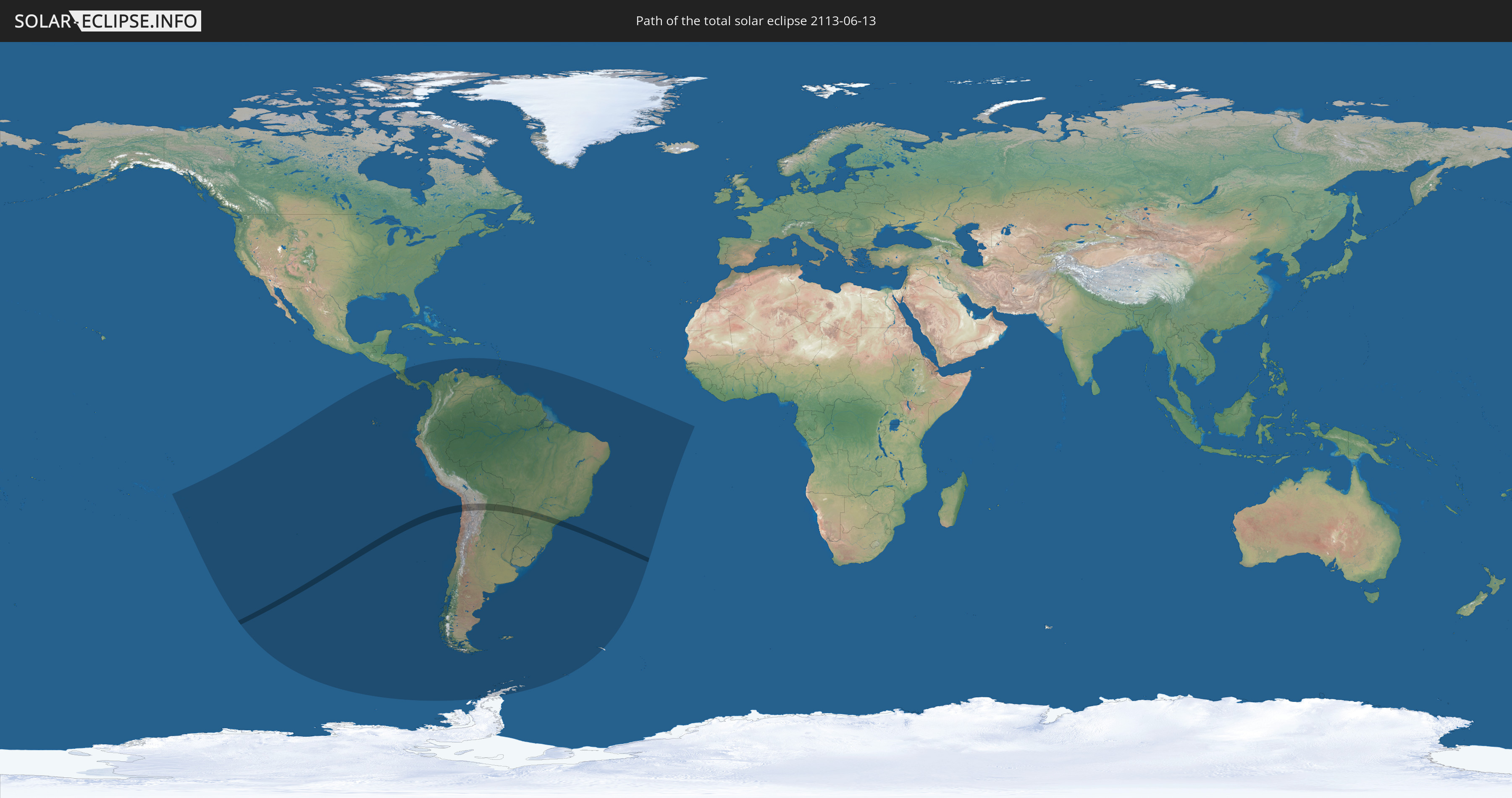
Die Sonnenfinsternis am 13.06.2113 kann man in 27 Ländern als partielle Sonnenfinsternis beobachten.
Der Finsternispfad verläuft durch 4 Länder. Nur in diesen Ländern ist sie als totale Sonnenfinsternis zu sehen.
In den folgenden Ländern ist die Sonnenfinsternis total zu sehen
 Chile
Chile
 Brasilien
 Bolivien
 Paraguay
In den folgenden Ländern ist die Sonnenfinsternis partiell zu sehen
 Antarktika
 Französisch-Polynesien
 Pitcairninseln
 Chile
Chile
 Ecuador
 Nicaragua
 Costa Rica
 Panama
 Kolumbien
 Peru
Peru
 Brasilien
 Argentinien
 Venezuela
 Aruba
Aruba
 Bolivien
 Paraguay
 Trinidad und Tobago
 Grenada
 St. Vincent und die Grenadinen
 Falklandinseln
 Guyana
 St. Lucia
 Barbados
 Uruguay
 Suriname
 Französisch-Guayana
 Südgeorgien und die Südlichen Sandwichinseln
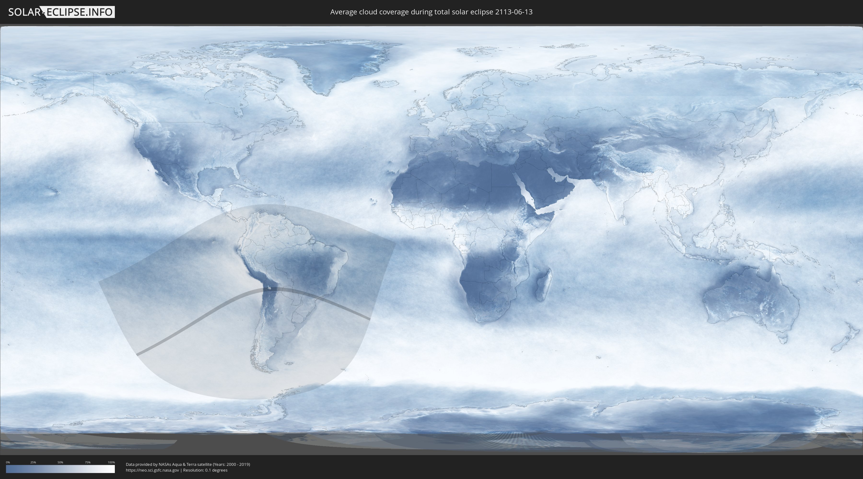
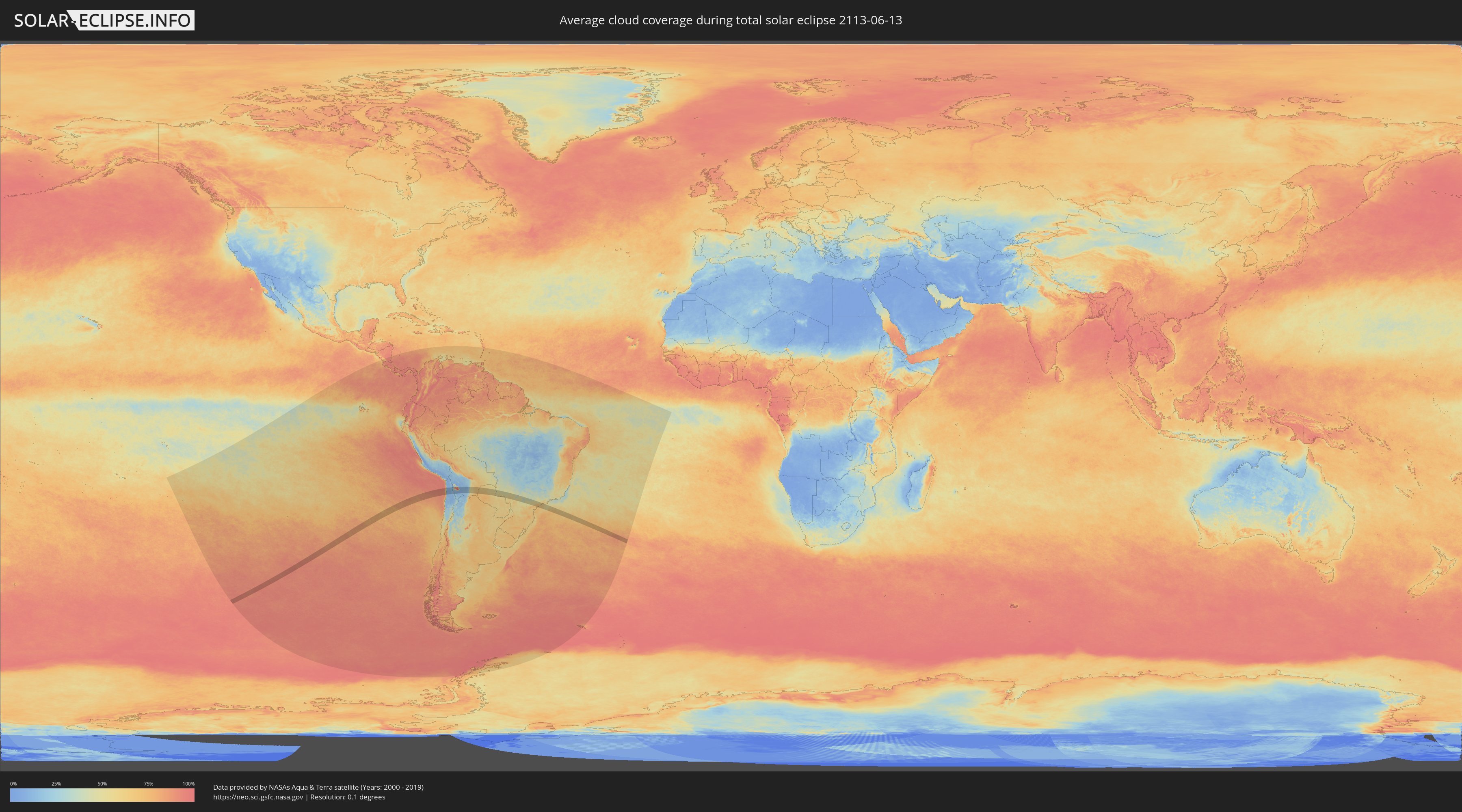
Wie wird das Wetter während der totalen Sonnenfinsternis am 13.06.2113?
Wo ist der beste Ort, um die totale Sonnenfinsternis vom 13.06.2113 zu beobachten?
Die folgenden Karten zeigen die durchschnittliche Bewölkung für den Tag, an dem die totale Sonnenfinsternis
stattfindet. Mit Hilfe der Karten lässt sich der Ort entlang des Finsternispfades eingrenzen,
der die besten Aussichen auf einen klaren wolkenfreien Himmel bietet.
Trotzdem muss man immer lokale Gegenenheiten beachten und sollte sich genau über das Wetter an seinem
gewählten Beobachtungsort informieren.
Die Daten stammen von den beiden NASA-Satelliten
AQUA und TERRA
und wurden über einen Zeitraum von 19 Jahren (2000 - 2019) gemittelt.
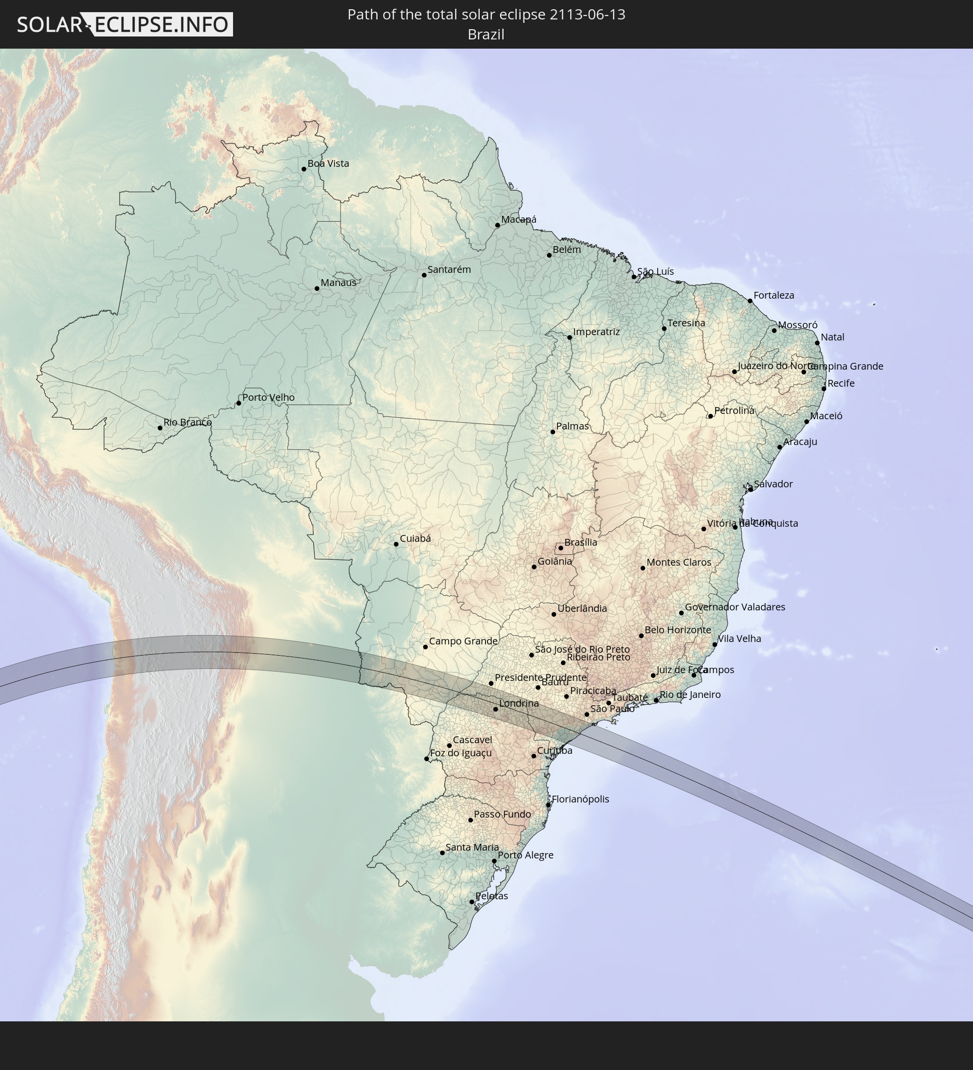
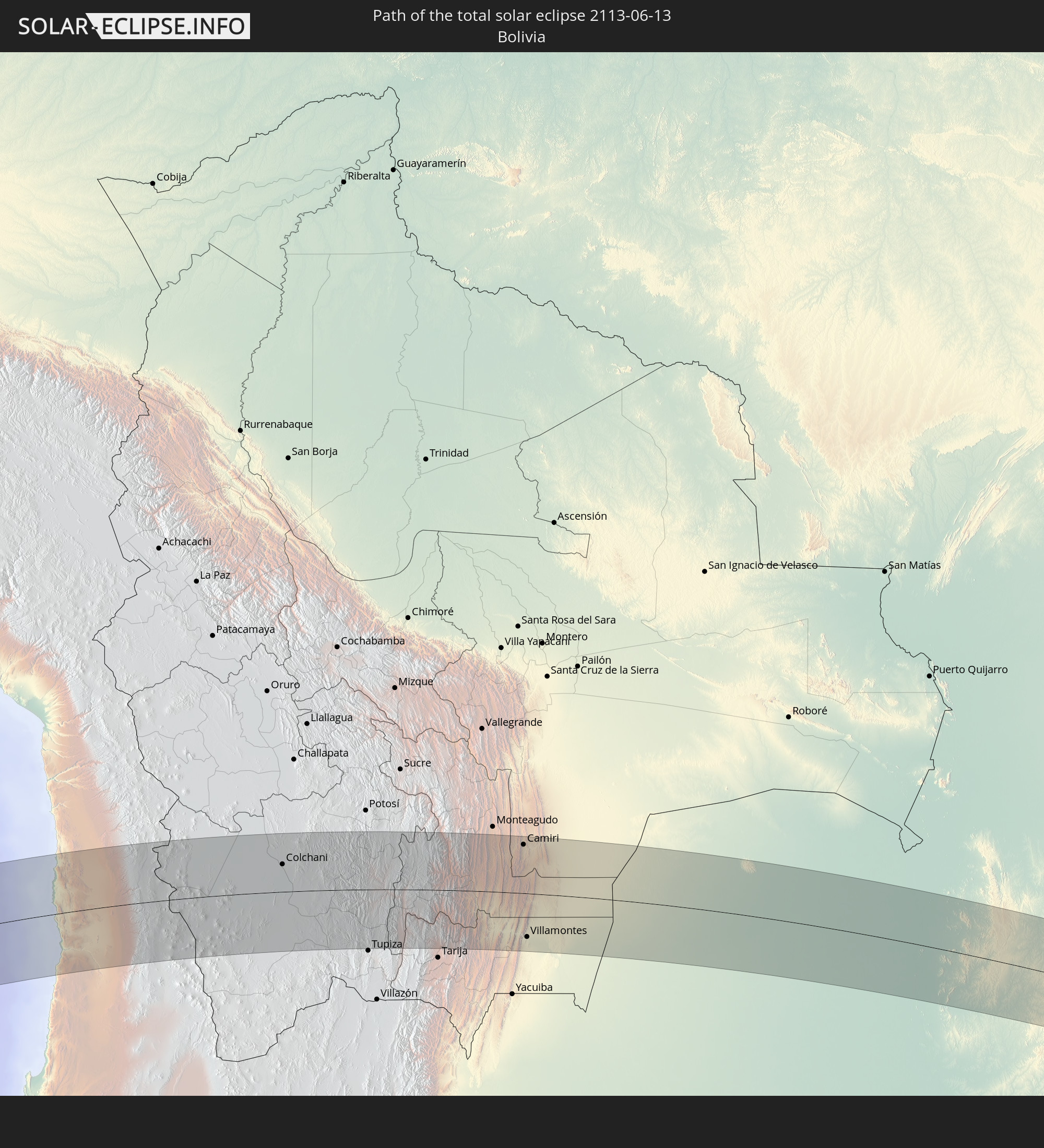
Detaillierte Länderkarten
 Chile
Chile
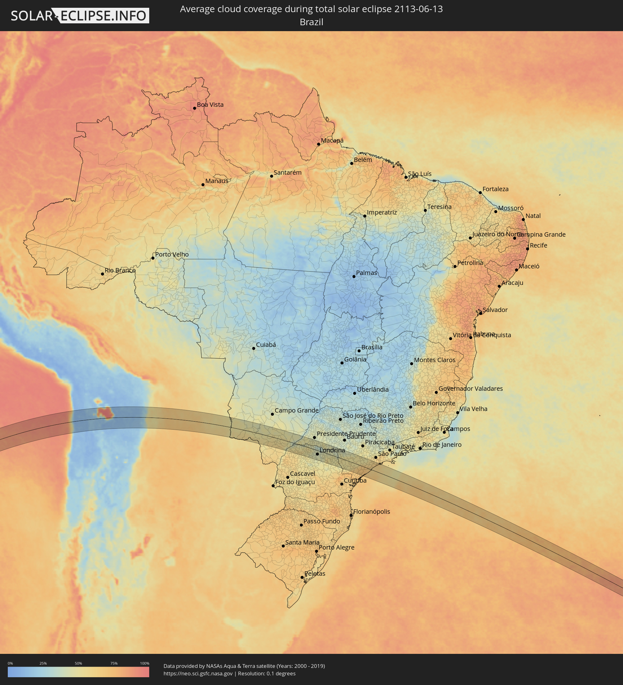 Brasilien
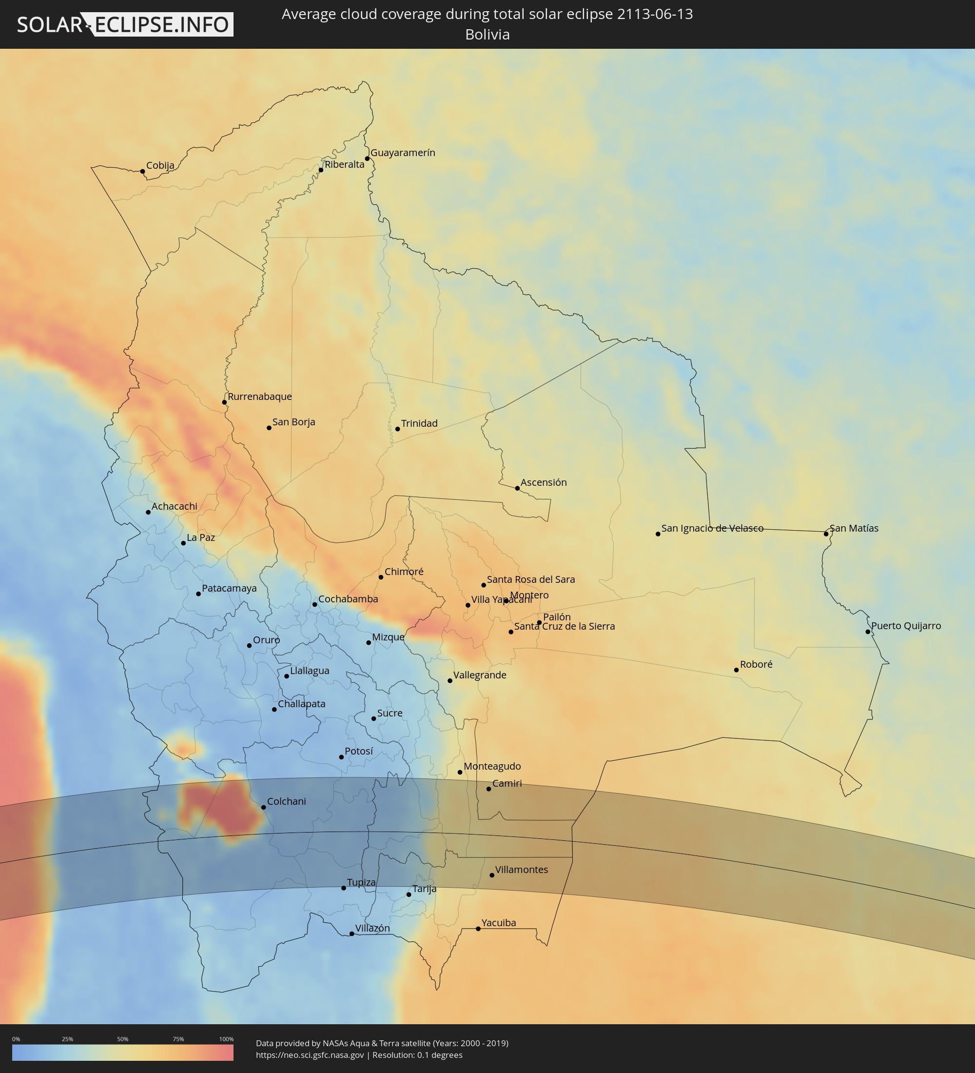 Bolivien
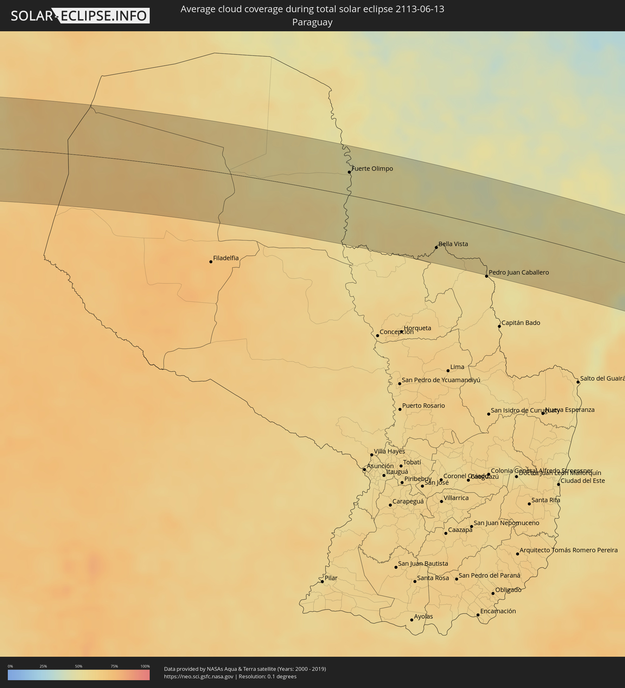 Paraguay
Orte im Finsternispfad
Die nachfolgene Tabelle zeigt Städte und Orte mit mehr als 5.000 Einwohnern, die sich im Finsternispfad befinden. Städte mit mehr als 100.000 Einwohnern sind dick gekennzeichnet. Mit einem Klick auf den Ort öffnet sich eine Detailkarte die die Lage des jeweiligen Ortes zusammen mit dem Verlauf der zentralen Finsternis präsentiert.
| Ort | Typ | Dauer der Verfinsterung | Ortszeit bei maximaler Verfinsterung | Entfernung zur Zentrallinie | Ø Bewölkung |
|
Iquique, Tarapacá
|
total | - | 14:33:52 UTC-03:00 | 81 km | 32% |
|
Colchani, Potosí
|
total | - | 13:43:08 UTC-04:00 | 41 km | 28% |
|
Uyuni, Potosí
|
total | - | 13:43:19 UTC-04:00 | 22 km | 10% |
|
Camiri, Santa Cruz
|
total | - | 13:52:50 UTC-04:00 | 72 km | 57% |
|
Villamontes, Tarija
|
total | - | 13:52:02 UTC-04:00 | 64 km | 62% |
|
Fuerte Olimpo, Alto Paraguay
|
total | - | 15:06:20 UTC-03:00 | 36 km | 49% |
|
Bela Vista, Mato Grosso do Sul
|
total | - | 15:08:35 UTC-03:00 | 51 km | 53% |
|
Bella Vista, Amambay
|
total | - | 15:08:35 UTC-03:00 | 53 km | 53% |
|
Jardim, Mato Grosso do Sul
|
total | - | 14:09:57 UTC-04:00 | 27 km | 47% |
|
Maracaju, Mato Grosso do Sul
|
total | - | 14:11:58 UTC-04:00 | 36 km | 48% |
|
Dourados, Mato Grosso do Sul
|
total | - | 14:12:15 UTC-04:00 | 20 km | 52% |
|
Rio Brilhante, Mato Grosso do Sul
|
total | - | 14:13:08 UTC-04:00 | 32 km | 49% |
|
Pôrto Barra do Ivinheima, Mato Grosso do Sul
|
total | - | 14:14:01 UTC-04:00 | 69 km | 48% |
|
Loanda, Paraná
|
total | - | 15:15:07 UTC-03:00 | 49 km | 52% |
|
Paranavaí, Paraná
|
total | - | 15:16:20 UTC-03:00 | 45 km | 57% |
|
Teodoro Sampaio, São Paulo
|
total | - | 15:17:21 UTC-03:00 | 22 km | 41% |
|
Mandaguaçu, Paraná
|
total | - | 15:16:49 UTC-03:00 | 63 km | 50% |
|
Colorado, Paraná
|
total | - | 15:17:29 UTC-03:00 | 5 km | 54% |
|
Maringá, Paraná
|
total | - | 15:17:03 UTC-03:00 | 66 km | 50% |
|
Mandaguari, Paraná
|
total | - | 15:17:28 UTC-03:00 | 71 km | 46% |
|
Astorga, Paraná
|
total | - | 15:17:44 UTC-03:00 | 37 km | 46% |
|
Pirapozinho, São Paulo
|
total | - | 15:18:51 UTC-03:00 | 69 km | 47% |
|
Apucarana, Paraná
|
total | - | 15:17:51 UTC-03:00 | 65 km | 46% |
|
Arapongas, Paraná
|
total | - | 15:18:02 UTC-03:00 | 49 km | 43% |
|
Londrina, Paraná
|
total | - | 15:18:37 UTC-03:00 | 30 km | 42% |
|
Cornélio Procópio, Paraná
|
total | - | 15:19:41 UTC-03:00 | 1 km | 46% |
|
Assis, São Paulo
|
total | - | 15:20:33 UTC-03:00 | 63 km | 44% |
|
Bandeirantes, Paraná
|
total | - | 15:20:15 UTC-03:00 | 17 km | 44% |
|
Palmital, São Paulo
|
total | - | 15:20:48 UTC-03:00 | 56 km | 43% |
|
Ibaiti, Paraná
|
total | - | 15:19:57 UTC-03:00 | 55 km | 50% |
|
Santo Antônio da Platina, Paraná
|
total | - | 15:20:37 UTC-03:00 | 7 km | 47% |
|
Cambará, Paraná
|
total | - | 15:20:50 UTC-03:00 | 34 km | 43% |
|
Jacarezinho, Paraná
|
total | - | 15:20:56 UTC-03:00 | 25 km | 45% |
|
Ourinhos, São Paulo
|
total | - | 15:21:15 UTC-03:00 | 47 km | 40% |
|
Wenceslau Braz, Paraná
|
total | - | 15:20:37 UTC-03:00 | 44 km | 48% |
|
Santa Cruz do Rio Pardo, São Paulo
|
total | - | 15:21:45 UTC-03:00 | 64 km | 41% |
|
Sengés, Paraná
|
total | - | 15:21:00 UTC-03:00 | 58 km | 46% |
|
Piraju, São Paulo
|
total | - | 15:21:56 UTC-03:00 | 41 km | 46% |
|
Itararé, São Paulo
|
total | - | 15:21:14 UTC-03:00 | 53 km | 47% |
|
Taquarituba, São Paulo
|
total | - | 15:21:53 UTC-03:00 | 10 km | 52% |
|
Itaí, São Paulo
|
total | - | 15:22:15 UTC-03:00 | 28 km | 49% |
|
Avaré, São Paulo
|
total | - | 15:22:48 UTC-03:00 | 67 km | 43% |
|
Itapeva, São Paulo
|
total | - | 15:22:08 UTC-03:00 | 24 km | 50% |
|
Paranapanema, São Paulo
|
total | - | 15:22:54 UTC-03:00 | 44 km | 50% |
|
Buri, São Paulo
|
total | - | 15:22:47 UTC-03:00 | 5 km | 52% |
|
Capâo Bonito, São Paulo
|
total | - | 15:23:00 UTC-03:00 | 8 km | 53% |
|
Itapetininga, São Paulo
|
total | - | 15:23:51 UTC-03:00 | 46 km | 52% |
|
Registro, São Paulo
|
total | - | 15:23:25 UTC-03:00 | 41 km | 69% |
|
Pilar do Sul, São Paulo
|
total | - | 15:24:13 UTC-03:00 | 34 km | 51% |
|
Salto de Pirapora, São Paulo
|
total | - | 15:24:36 UTC-03:00 | 57 km | 49% |
|
Iguape, São Paulo
|
total | - | 15:23:42 UTC-03:00 | 53 km | 66% |
|
Piedade, São Paulo
|
total | - | 15:24:47 UTC-03:00 | 55 km | 51% |
|
Peruíbe, São Paulo
|
total | - | 15:24:56 UTC-03:00 | 7 km | 60% |
|
Embu Guaçu, São Paulo
|
total | - | 15:25:39 UTC-03:00 | 65 km | 61% |
|
Itanhaém, São Paulo
|
total | - | 15:25:23 UTC-03:00 | 29 km | 60% |
|
Mongaguá, São Paulo
|
total | - | 15:25:44 UTC-03:00 | 45 km | 61% |
|
São Vicente, São Paulo
|
total | - | 15:26:12 UTC-03:00 | 67 km | 61% |