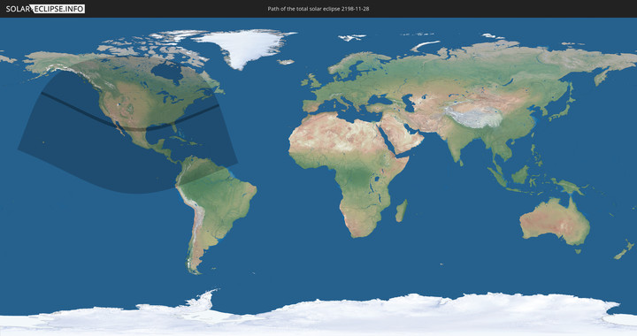
Totale Sonnenfinsternis vom 28.11.2198
| Wochentag: | Mittwoch |
| Maximale Dauer der Verfinsterung: | 03m58s |
| Maximale Breite des Finsternispfades: | 221 km |
| Saroszyklus: | 155 |
| Bedeckungsgrad: | 100% |
| Magnitude: | 1.0442 |
| Gamma: | 0.7459 |
Wo kann man die Sonnenfinsternis vom 28.11.2198 sehen?
Die Sonnenfinsternis am 28.11.2198 kann man in 46 Ländern als partielle Sonnenfinsternis beobachten.
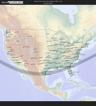
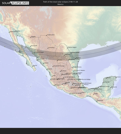
Der Finsternispfad verläuft durch 2 Länder. Nur in diesen Ländern ist sie als totale Sonnenfinsternis zu sehen.
In den folgenden Ländern ist die Sonnenfinsternis total zu sehen
In den folgenden Ländern ist die Sonnenfinsternis partiell zu sehen
 Vereinigte Staaten
 United States Minor Outlying Islands
 Kanada
 Mexiko
 Grönland
 Guatemala
 Ecuador
 El Salvador
 Honduras
 Belize
 Nicaragua
 Costa Rica
 Kuba
Kuba
 Panama
 Kolumbien
 Kaimaninseln
 Peru
Peru
 Bahamas
 Jamaika
 Haiti
Haiti
 Brasilien
 Venezuela
 Turks- und Caicosinseln
 Dominikanische Republik
 Aruba
Aruba
 Puerto Rico
 Amerikanische Jungferninseln
 Bermuda
 Britische Jungferninseln
 Anguilla
 Saint-Martin
 Saint-Barthélemy
 St. Kitts und Nevis
 Antigua und Barbuda
 Montserrat
 Trinidad und Tobago
 Guadeloupe
 Grenada
 Dominica
 St. Vincent und die Grenadinen
 Guyana
 Martinique
 St. Lucia
 Barbados
 Suriname
 Französisch-Guayana
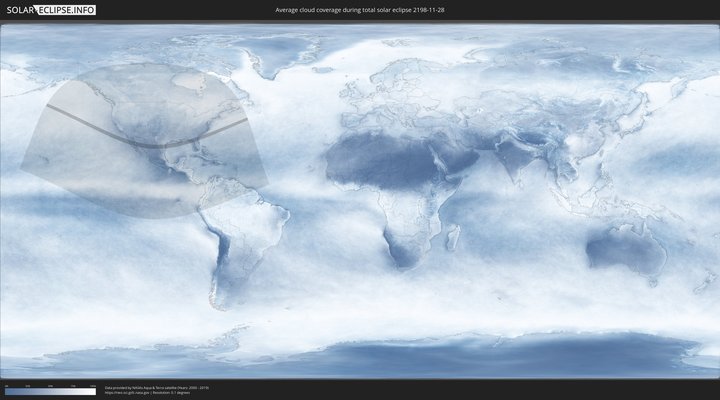
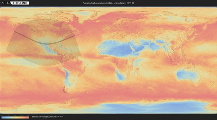
Wie wird das Wetter während der totalen Sonnenfinsternis am 28.11.2198?
Wo ist der beste Ort, um die totale Sonnenfinsternis vom 28.11.2198 zu beobachten?
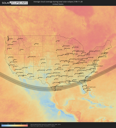
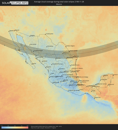
Die folgenden Karten zeigen die durchschnittliche Bewölkung für den Tag, an dem die totale Sonnenfinsternis
stattfindet. Mit Hilfe der Karten lässt sich der Ort entlang des Finsternispfades eingrenzen,
der die besten Aussichen auf einen klaren wolkenfreien Himmel bietet.
Trotzdem muss man immer lokale Gegenenheiten beachten und sollte sich genau über das Wetter an seinem
gewählten Beobachtungsort informieren.
Die Daten stammen von den beiden NASA-Satelliten
AQUA und TERRA
und wurden über einen Zeitraum von 19 Jahren (2000 - 2019) gemittelt.
Detaillierte Länderkarten
Orte im Finsternispfad
Die nachfolgene Tabelle zeigt Städte und Orte mit mehr als 5.000 Einwohnern, die sich im Finsternispfad befinden. Städte mit mehr als 100.000 Einwohnern sind dick gekennzeichnet. Mit einem Klick auf den Ort öffnet sich eine Detailkarte die die Lage des jeweiligen Ortes zusammen mit dem Verlauf der zentralen Finsternis präsentiert.
| Ort | Typ | Dauer der Verfinsterung | Ortszeit bei maximaler Verfinsterung | Entfernung zur Zentrallinie | Ø Bewölkung |
 San Luis, Baja California
|
total | - | 10:45:06 UTC-08:00 | 3 km | 40% |
 Villa Alberto Andrés Alvarado Arámburo, Baja California Sur
|
total | - | 11:46:04 UTC-07:00 | 76 km | 39% |
 Santa Rosalia, Baja California Sur
|
total | - | 11:48:56 UTC-07:00 | 77 km | 36% |
 Bahía de Kino, Sonora
|
total | - | 11:49:36 UTC-07:00 | 91 km | 43% |
 Miguel Alemán (La Doce), Sonora
|
total | - | 11:50:46 UTC-07:00 | 105 km | 42% |
 Heroica Guaymas, Sonora
|
total | - | 11:52:23 UTC-07:00 | 21 km | 40% |
 Empalme, Sonora
|
total | - | 11:52:35 UTC-07:00 | 27 km | 44% |
 Potam, Sonora
|
total | - | 11:53:40 UTC-07:00 | 1 km | 43% |
 Vicam, Sonora
|
total | - | 11:53:59 UTC-07:00 | 5 km | 41% |
 San Ignacio Río Muerto, Sonora
|
total | - | 11:54:09 UTC-07:00 | 18 km | 41% |
 Campo Sesenta, Sonora
|
total | - | 11:54:31 UTC-07:00 | 11 km | 40% |
 Pueblo Yaqui, Sonora
|
total | - | 11:54:43 UTC-07:00 | 20 km | 40% |
 Cocorit, Sonora
|
total | - | 11:54:52 UTC-07:00 | 6 km | 39% |
 Ciudad Obregón, Sonora
|
total | - | 11:54:56 UTC-07:00 | 4 km | 38% |
 El Tobarito, Sonora
|
total | - | 11:55:05 UTC-07:00 | 15 km | 39% |
 Marte R. Gómez (Tobarito), Sonora
|
total | - | 11:55:06 UTC-07:00 | 15 km | 39% |
 Villa Juarez, Sonora
|
total | - | 11:55:16 UTC-07:00 | 40 km | 44% |
 Bacobampo, Sonora
|
total | - | 11:55:47 UTC-07:00 | 52 km | 43% |
 Huatabampo, Sonora
|
total | - | 11:55:50 UTC-07:00 | 69 km | 42% |
 Etchojoa, Sonora
|
total | - | 11:55:52 UTC-07:00 | 59 km | 42% |
 La Unión, Sonora
|
total | - | 11:55:56 UTC-07:00 | 69 km | 42% |
 Navojoa, Sonora
|
total | - | 11:56:19 UTC-07:00 | 38 km | 40% |
 Alamos, Sonora
|
total | - | 11:57:40 UTC-07:00 | 33 km | 38% |
 El Fuerte de Montes Claros, Sinaloa
|
total | - | 11:58:38 UTC-07:00 | 93 km | 36% |
 Choix, Sinaloa
|
total | - | 11:59:20 UTC-07:00 | 56 km | 37% |
 Creel, Chihuahua
|
total | - | 12:00:55 UTC-07:00 | 70 km | 38% |
 Santa Bárbara, Chihuahua
|
total | - | 12:05:59 UTC-07:00 | 8 km | 34% |
 Hidalgo del Parral, Chihuahua
|
total | - | 12:06:21 UTC-07:00 | 8 km | 35% |
 Santa María del Oro, Durango
|
total | - | 13:07:27 UTC-06:00 | 97 km | 30% |
 Ciudad Camargo, Chihuahua
|
total | - | 12:07:26 UTC-07:00 | 96 km | 39% |
 Bermejillo, Durango
|
total | - | 13:12:08 UTC-06:00 | 90 km | 33% |
 Poanas, Durango
|
total | - | 13:12:13 UTC-06:00 | 103 km | 35% |
 Tlahualilo de Zaragoza, Durango
|
total | - | 13:12:32 UTC-06:00 | 65 km | 31% |
 San Antonio del Coyote, Coahuila
|
total | - | 13:13:06 UTC-06:00 | 110 km | 36% |
 Coyote, Coahuila
|
total | - | 13:13:06 UTC-06:00 | 110 km | 36% |
 Concordia, Coahuila
|
total | - | 13:13:31 UTC-06:00 | 99 km | 34% |
 San Buenaventura, Coahuila
|
total | - | 13:17:11 UTC-06:00 | 47 km | 43% |
 Ciudad Frontera, Coahuila
|
total | - | 13:17:29 UTC-06:00 | 32 km | 37% |
 Castaños, Coahuila
|
total | - | 13:17:36 UTC-06:00 | 17 km | 38% |
 Monclova, Coahuila
|
total | - | 13:17:35 UTC-06:00 | 30 km | 40% |
 García, Nuevo León
|
total | - | 13:20:11 UTC-06:00 | 93 km | 45% |
 Lampazos de Naranjo, Nuevo León
|
total | - | 13:19:55 UTC-06:00 | 42 km | 46% |
 Valle de Lincoln, Nuevo León
|
total | - | 13:20:30 UTC-06:00 | 95 km | 47% |
 Santa Catarina, Nuevo León
|
total | - | 13:20:36 UTC-06:00 | 109 km | 40% |
 Parque Industrial Ciudad Mitras, Nuevo León
|
total | - | 13:20:34 UTC-06:00 | 96 km | 51% |
 Mitras Poniente, Nuevo León
|
total | - | 13:20:38 UTC-06:00 | 98 km | 51% |
 Monterrey, Nuevo León
|
total | - | 13:20:57 UTC-06:00 | 109 km | 51% |
 General Escobedo, Nuevo León
|
total | - | 13:20:55 UTC-06:00 | 96 km | 54% |
 San Nicolás de los Garza, Nuevo León
|
total | - | 13:20:58 UTC-06:00 | 102 km | 51% |
 Emiliano Zapata, Nuevo León
|
total | - | 13:20:58 UTC-06:00 | 83 km | 52% |
 Guadalupe, Nuevo León
|
total | - | 13:21:07 UTC-06:00 | 109 km | 51% |
 Villas de Alcalá, Nuevo León
|
total | - | 13:21:12 UTC-06:00 | 83 km | 54% |
 Sabinas Hidalgo, Nuevo León
|
total | - | 13:20:58 UTC-06:00 | 17 km | 46% |
 Real del Sol, Nuevo León
|
total | - | 13:21:12 UTC-06:00 | 80 km | 54% |
 Ciénega de Flores, Nuevo León
|
total | - | 13:21:14 UTC-06:00 | 78 km | 52% |
 Apodaca, Nuevo León
|
total | - | 13:21:20 UTC-06:00 | 100 km | 57% |
 Fraccionamiento Real Palmas, Nuevo León
|
total | - | 13:21:17 UTC-06:00 | 84 km | 54% |
 Misión San Pablo, Nuevo León
|
total | - | 13:21:23 UTC-06:00 | 102 km | 53% |
 Loma la Paz, Nuevo León
|
total | - | 13:21:25 UTC-06:00 | 106 km | 53% |
 Ciudad Anáhuac, Nuevo León
|
total | - | 13:20:47 UTC-06:00 | 65 km | 49% |
 Anáhuac, Nuevo León
|
total | - | 13:20:47 UTC-06:00 | 65 km | 49% |
 General Zuazua, Nuevo León
|
total | - | 13:21:25 UTC-06:00 | 85 km | 52% |
 Pesquería, Nuevo León
|
total | - | 13:21:37 UTC-06:00 | 98 km | 55% |
 El Campanario y Oradel, Tamaulipas
|
total | - | 13:22:00 UTC-06:00 | 88 km | 61% |
 Hidalgo, Nuevo León
|
total | - | 13:22:42 UTC-06:00 | 91 km | 50% |
 Nuevo Laredo, Tamaulipas
|
total | - | 13:22:16 UTC-06:00 | 88 km | 62% |
 Laredo, Texas
|
total | - | 13:22:16 UTC-06:00 | 91 km | 62% |
 Zapata, Texas
|
total | - | 13:23:08 UTC-06:00 | 23 km | 50% |
 Mier, Tamaulipas
|
total | - | 13:23:39 UTC-06:00 | 30 km | 56% |
 Ciudad Miguel Alemán, Tamaulipas
|
total | - | 13:23:59 UTC-06:00 | 34 km | 58% |
 Roma-Los Saenz, Texas
|
total | - | 13:24:01 UTC-06:00 | 34 km | 58% |
 Camargo, Tamaulipas
|
total | - | 13:24:31 UTC-06:00 | 52 km | 59% |
 Rio Grande City, Texas
|
total | - | 13:24:32 UTC-06:00 | 38 km | 60% |
 Ciudad Díaz Ordaz, Tamaulipas
|
total | - | 13:25:10 UTC-06:00 | 56 km | 58% |
 Perezville, Texas
|
total | - | 13:25:40 UTC-06:00 | 58 km | 63% |
 Doffing, Texas
|
total | - | 13:25:41 UTC-06:00 | 53 km | 64% |
 Palmview South, Texas
|
total | - | 13:25:44 UTC-06:00 | 59 km | 63% |
 Palmview, Texas
|
total | - | 13:25:44 UTC-06:00 | 57 km | 63% |
 La Homa, Texas
|
total | - | 13:25:45 UTC-06:00 | 56 km | 64% |
 Mission, Texas
|
total | - | 13:25:52 UTC-06:00 | 60 km | 66% |
 Alton, Texas
|
total | - | 13:25:52 UTC-06:00 | 52 km | 65% |
 Alton North (historical), Texas
|
total | - | 13:25:53 UTC-06:00 | 51 km | 65% |
 Reynosa, Tamaulipas
|
total | - | 13:26:01 UTC-06:00 | 75 km | 71% |
 Hidalgo, Texas
|
total | - | 13:26:04 UTC-06:00 | 73 km | 71% |
 McAllen, Texas
|
total | - | 13:26:07 UTC-06:00 | 62 km | 66% |
 Pharr, Texas
|
total | - | 13:26:14 UTC-06:00 | 63 km | 66% |
 Edinburg, Texas
|
total | - | 13:26:14 UTC-06:00 | 52 km | 67% |
 San Juan, Texas
|
total | - | 13:26:18 UTC-06:00 | 64 km | 66% |
 Alamo, Texas
|
total | - | 13:26:23 UTC-06:00 | 65 km | 65% |
 Nurillo, Texas
|
total | - | 13:26:21 UTC-06:00 | 56 km | 67% |
 Murillo Colonia, Texas
|
total | - | 13:26:23 UTC-06:00 | 57 km | 67% |
 Río Bravo, Tamaulipas
|
total | - | 13:26:33 UTC-06:00 | 87 km | 63% |
 Alice, Texas
|
total | - | 13:25:47 UTC-06:00 | 108 km | 68% |
 Donna, Texas
|
total | - | 13:26:35 UTC-06:00 | 67 km | 65% |
 Elsa, Texas
|
total | - | 13:26:40 UTC-06:00 | 54 km | 65% |
 Weslaco, Texas
|
total | - | 13:26:44 UTC-06:00 | 69 km | 64% |
 Mila Doce, Texas
|
total | - | 13:26:47 UTC-06:00 | 62 km | 64% |
 Progreso, Texas
|
total | - | 13:26:51 UTC-06:00 | 77 km | 63% |
 Mercedes, Texas
|
total | - | 13:26:56 UTC-06:00 | 71 km | 65% |
 Kingsville, Texas
|
total | - | 13:26:26 UTC-06:00 | 80 km | 70% |
 La Feria, Texas
|
total | - | 13:27:09 UTC-06:00 | 70 km | 65% |
 Raymondville, Texas
|
total | - | 13:27:07 UTC-06:00 | 35 km | 65% |
 Harlingen, Texas
|
total | - | 13:27:28 UTC-06:00 | 68 km | 68% |
 Robstown, Texas
|
total | - | 13:26:46 UTC-06:00 | 109 km | 63% |
 San Benito, Texas
|
total | - | 13:27:39 UTC-06:00 | 75 km | 69% |
 Heroica Matamoros, Tamaulipas
|
total | - | 13:28:06 UTC-06:00 | 104 km | 72% |
 Brownsville, Texas
|
total | - | 13:28:06 UTC-06:00 | 102 km | 72% |
 Cameron Park Colonia, Texas
|
total | - | 13:28:07 UTC-06:00 | 94 km | 70% |
 Cameron Park, Texas
|
total | - | 13:28:07 UTC-06:00 | 95 km | 70% |
 Los Fresnos, Texas
|
total | - | 13:28:04 UTC-06:00 | 83 km | 69% |
 Corpus Christi, Texas
|
total | - | 13:27:27 UTC-06:00 | 107 km | 63% |
 Port Isabel, Texas
|
total | - | 13:28:45 UTC-06:00 | 86 km | 60% |
 Springfield, Florida
|
total | - | 13:51:45 UTC-06:00 | 95 km | 45% |
 Callaway, Florida
|
total | - | 13:51:49 UTC-06:00 | 94 km | 45% |
 Tallahassee, Florida
|
total | - | 14:53:58 UTC-05:00 | 82 km | 48% |
 Perry, Florida
|
total | - | 14:55:26 UTC-05:00 | 25 km | 53% |
 Valdosta, Georgia
|
total | - | 14:55:25 UTC-05:00 | 90 km | 48% |
 Live Oak, Florida
|
total | - | 14:56:21 UTC-05:00 | 24 km | 53% |
 Lake City, Florida
|
total | - | 14:57:01 UTC-05:00 | 1 km | 55% |
 High Springs, Florida
|
total | - | 14:57:22 UTC-05:00 | 38 km | 52% |
 Alachua, Florida
|
total | - | 14:57:43 UTC-05:00 | 52 km | 47% |
 Gainesville, Florida
|
total | - | 14:57:57 UTC-05:00 | 66 km | 47% |
 Macclenny, Florida
|
total | - | 14:57:49 UTC-05:00 | 7 km | 54% |
 Starke, Florida
|
total | - | 14:58:06 UTC-05:00 | 43 km | 50% |
 Middleburg, Florida
|
total | - | 14:58:25 UTC-05:00 | 39 km | 53% |
 Asbury Lake, Florida
|
total | - | 14:58:30 UTC-05:00 | 42 km | 52% |
 Nassau Village-Ratliff, Florida
|
total | - | 14:58:09 UTC-05:00 | 5 km | 54% |
 Lakeside, Florida
|
total | - | 14:58:31 UTC-05:00 | 36 km | 52% |
 Bellair-Meadowbrook Terrace, Florida
|
total | - | 14:58:31 UTC-05:00 | 31 km | 48% |
 Orange Park, Florida
|
total | - | 14:58:36 UTC-05:00 | 34 km | 48% |
 Kingsland, Georgia
|
total | - | 14:58:07 UTC-05:00 | 31 km | 51% |
 Green Cove Springs, Florida
|
total | - | 14:58:46 UTC-05:00 | 53 km | 51% |
 Jacksonville, Florida
|
total | - | 14:58:33 UTC-05:00 | 19 km | 52% |
 Fruit Cove, Florida
|
total | - | 14:58:45 UTC-05:00 | 42 km | 51% |
 Palatka, Florida
|
total | - | 14:59:06 UTC-05:00 | 90 km | 47% |
 Yulee, Florida
|
total | - | 14:58:23 UTC-05:00 | 11 km | 48% |
 St. Marys, Georgia
|
total | - | 14:58:25 UTC-05:00 | 19 km | 52% |
 Dock Junction, Georgia
|
total | - | 14:58:05 UTC-05:00 | 67 km | 49% |
 Brunswick, Georgia
|
total | - | 14:58:10 UTC-05:00 | 60 km | 54% |
 Country Club Estates, Georgia
|
total | - | 14:58:09 UTC-05:00 | 66 km | 49% |
 Fernandina Beach, Florida
|
total | - | 14:58:36 UTC-05:00 | 10 km | 52% |
 Saint Simon Mills, Georgia
|
total | - | 14:58:17 UTC-05:00 | 59 km | 48% |
 Atlantic Beach, Florida
|
total | - | 14:58:58 UTC-05:00 | 27 km | 50% |
 Neptune Beach, Florida
|
total | - | 14:58:59 UTC-05:00 | 30 km | 50% |
 Jacksonville Beach, Florida
|
total | - | 14:59:00 UTC-05:00 | 32 km | 50% |
 Palm Valley, Florida
|
total | - | 14:59:06 UTC-05:00 | 44 km | 51% |
 Ponte Vedra Beach, Florida
|
total | - | 14:59:04 UTC-05:00 | 38 km | 51% |
 Saint Simons Island, Georgia
|
total | - | 14:58:22 UTC-05:00 | 56 km | 48% |
 Saint Augustine, Florida
|
total | - | 14:59:27 UTC-05:00 | 76 km | 49% |
 Saint Augustine Shores, Florida
|
total | - | 14:59:31 UTC-05:00 | 85 km | 47% |
 Saint Augustine Beach, Florida
|
total | - | 14:59:34 UTC-05:00 | 82 km | 49% |
