Totale Sonnenfinsternis vom 14.04.2200
| Wochentag: | Montag |
| Maximale Dauer der Verfinsterung: | 01m23s |
| Maximale Breite des Finsternispfades: | 69 km |
| Saroszyklus: | 132 |
| Bedeckungsgrad: | 100% |
| Magnitude: | 1.0165 |
| Gamma: | 0.5847 |
Wo kann man die Sonnenfinsternis vom 14.04.2200 sehen?
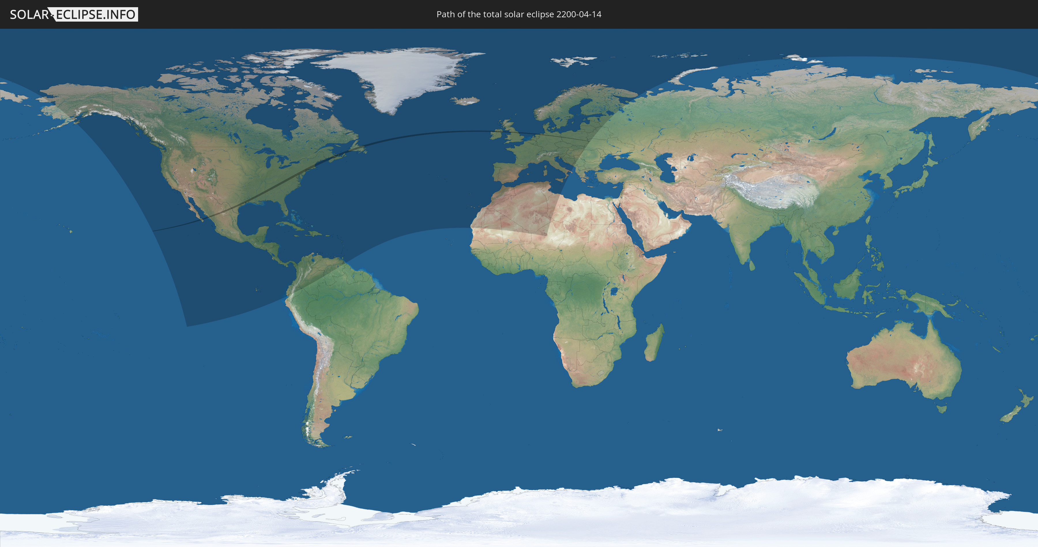
Die Sonnenfinsternis am 14.04.2200 kann man in 96 Ländern als partielle Sonnenfinsternis beobachten.
Der Finsternispfad verläuft durch 10 Länder. Nur in diesen Ländern ist sie als totale Sonnenfinsternis zu sehen.
In den folgenden Ländern ist die Sonnenfinsternis total zu sehen
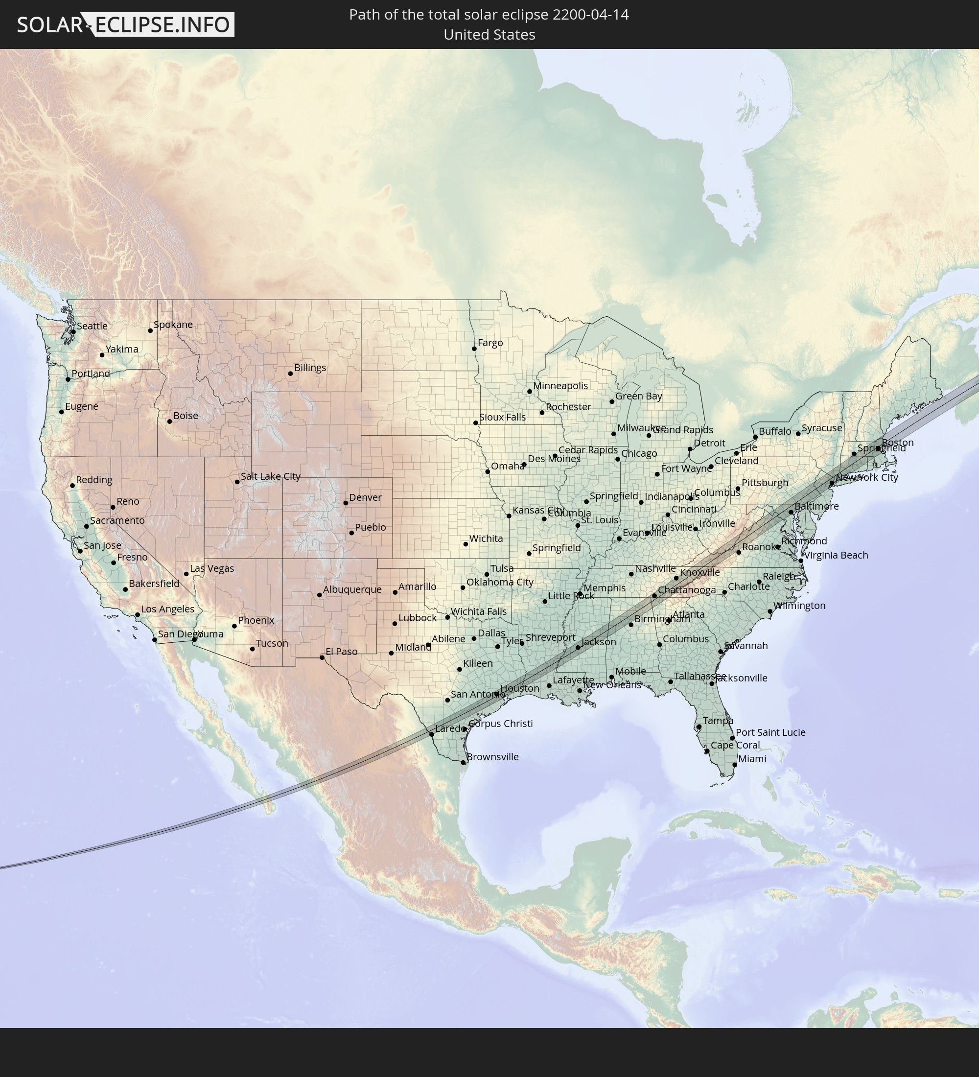 Vereinigte Staaten
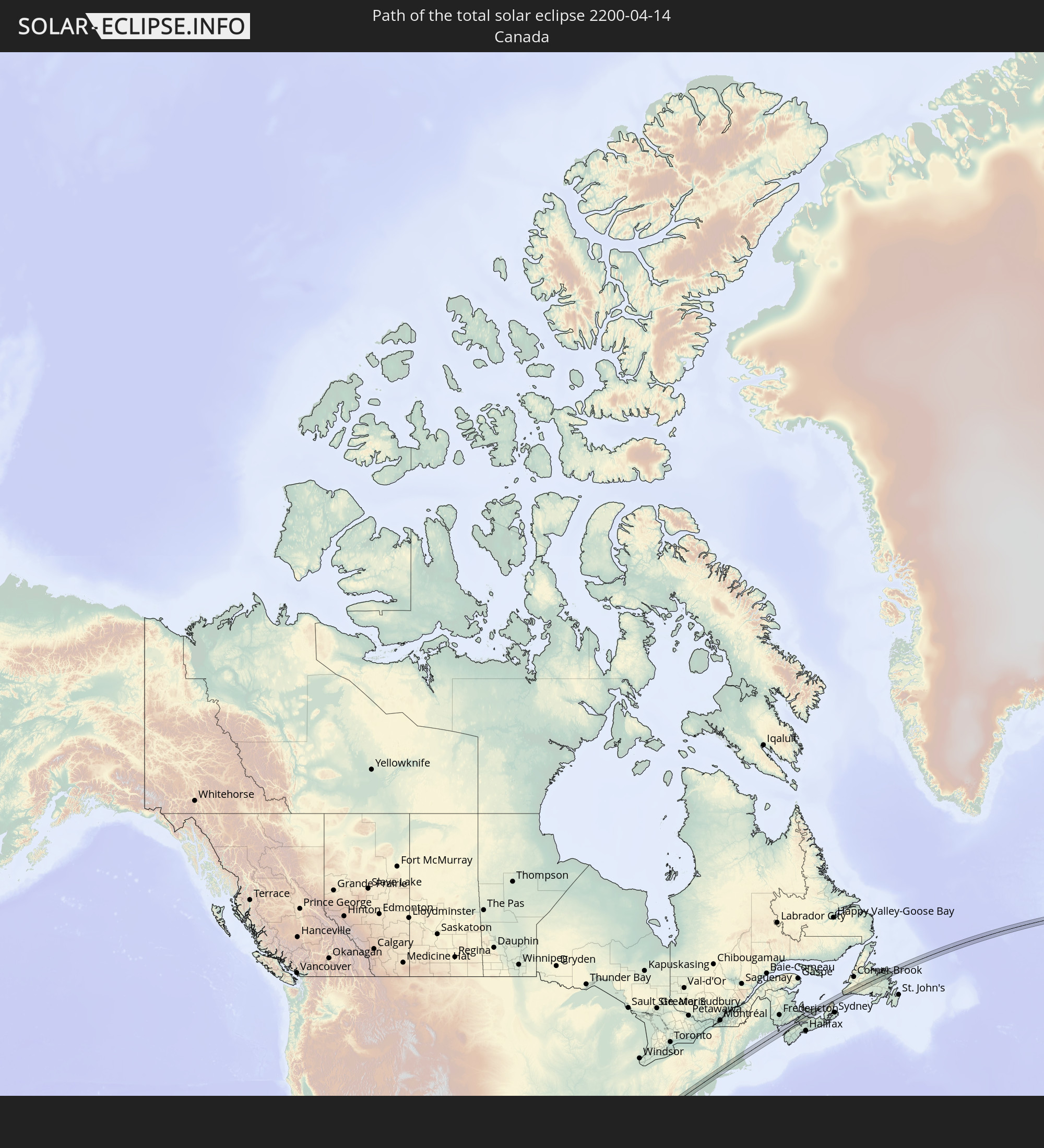 Kanada
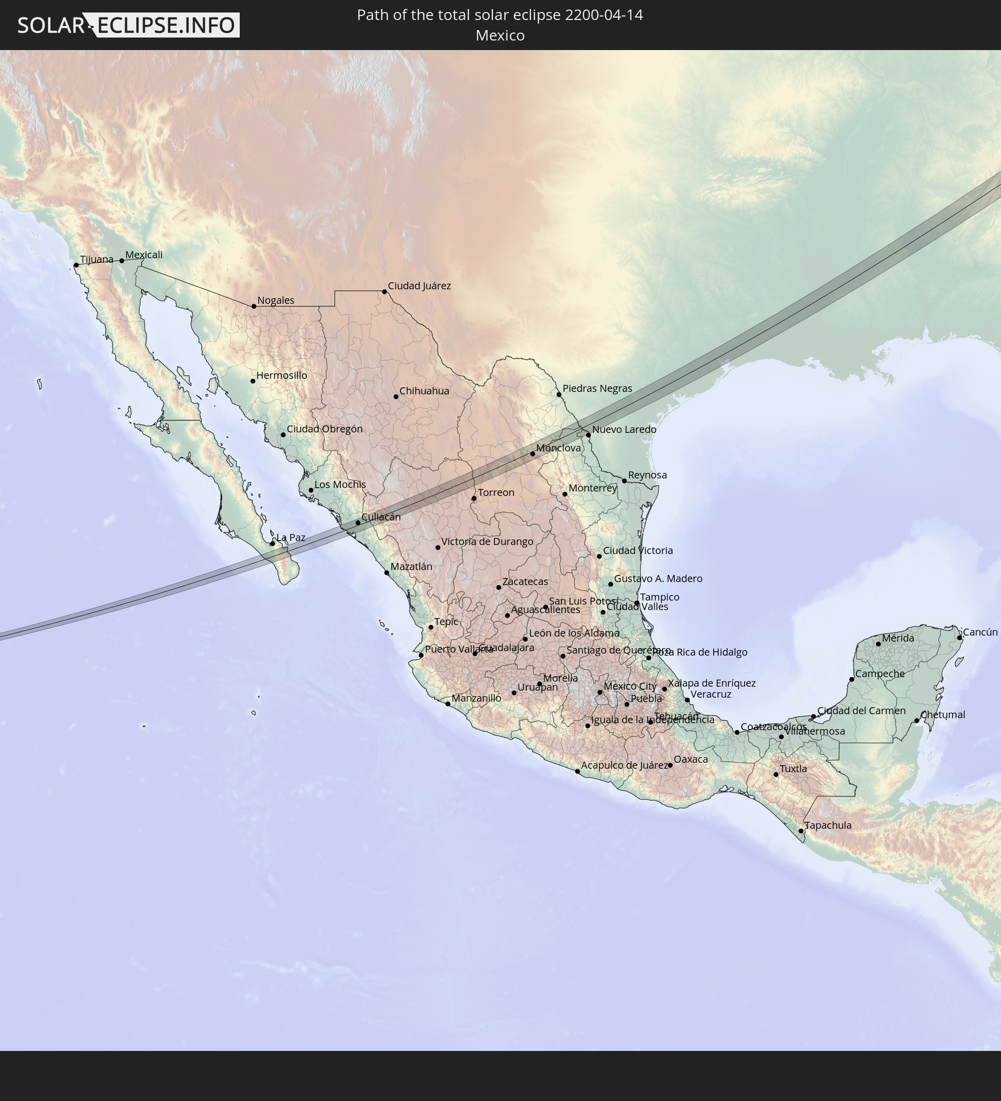 Mexiko
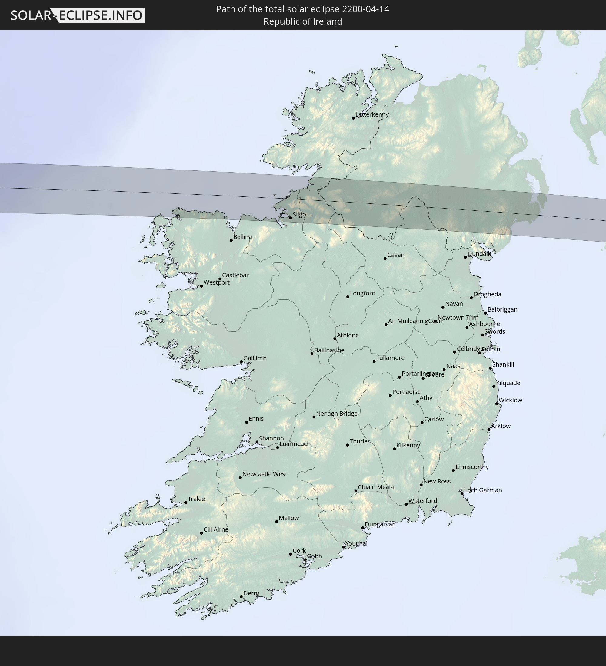 Irland
 Vereinigtes Königreich
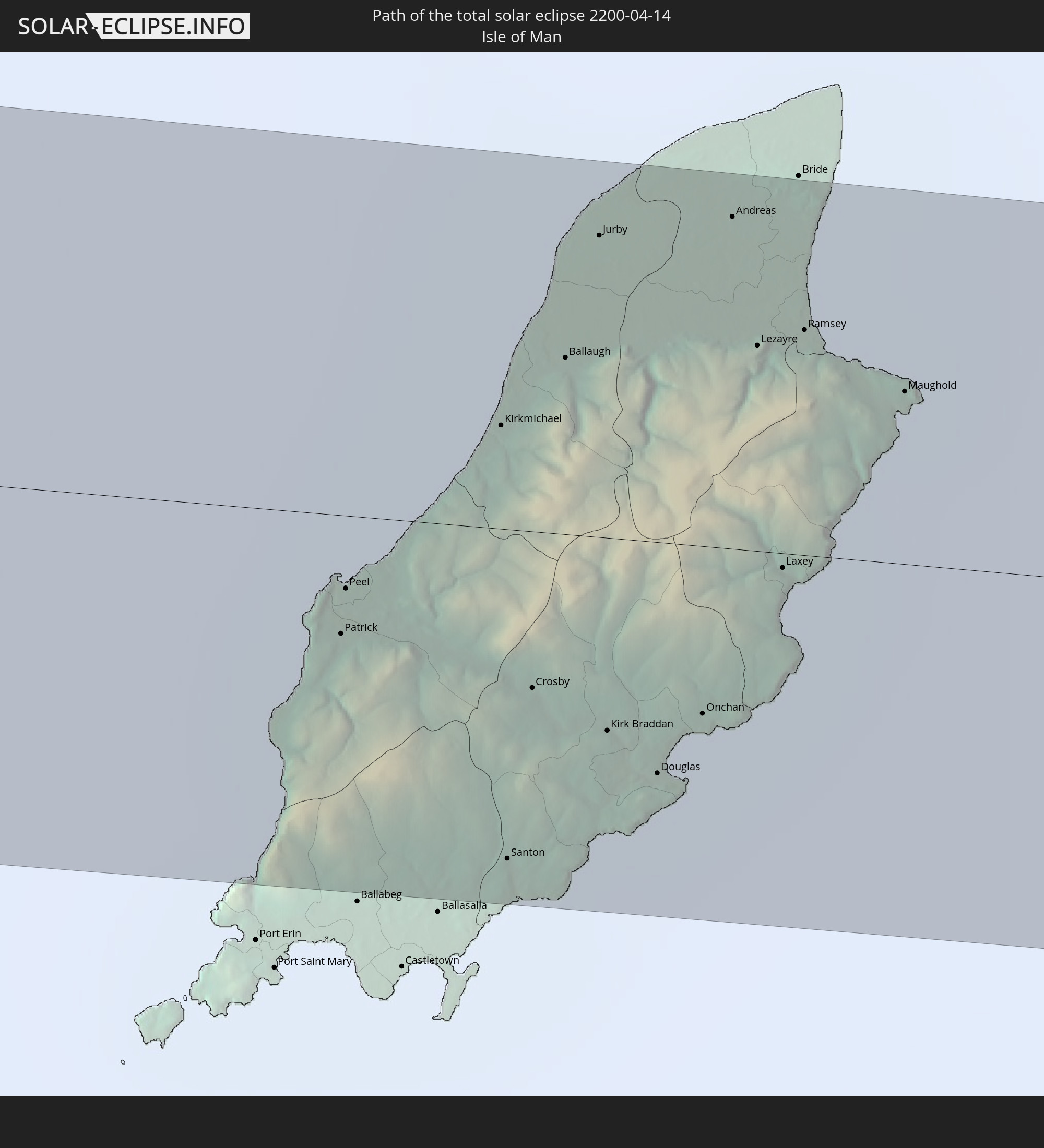 Isle of Man
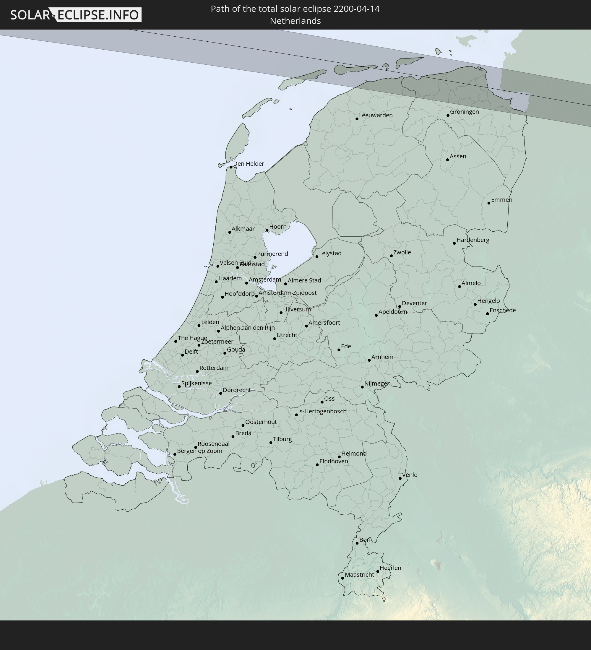 Niederlande
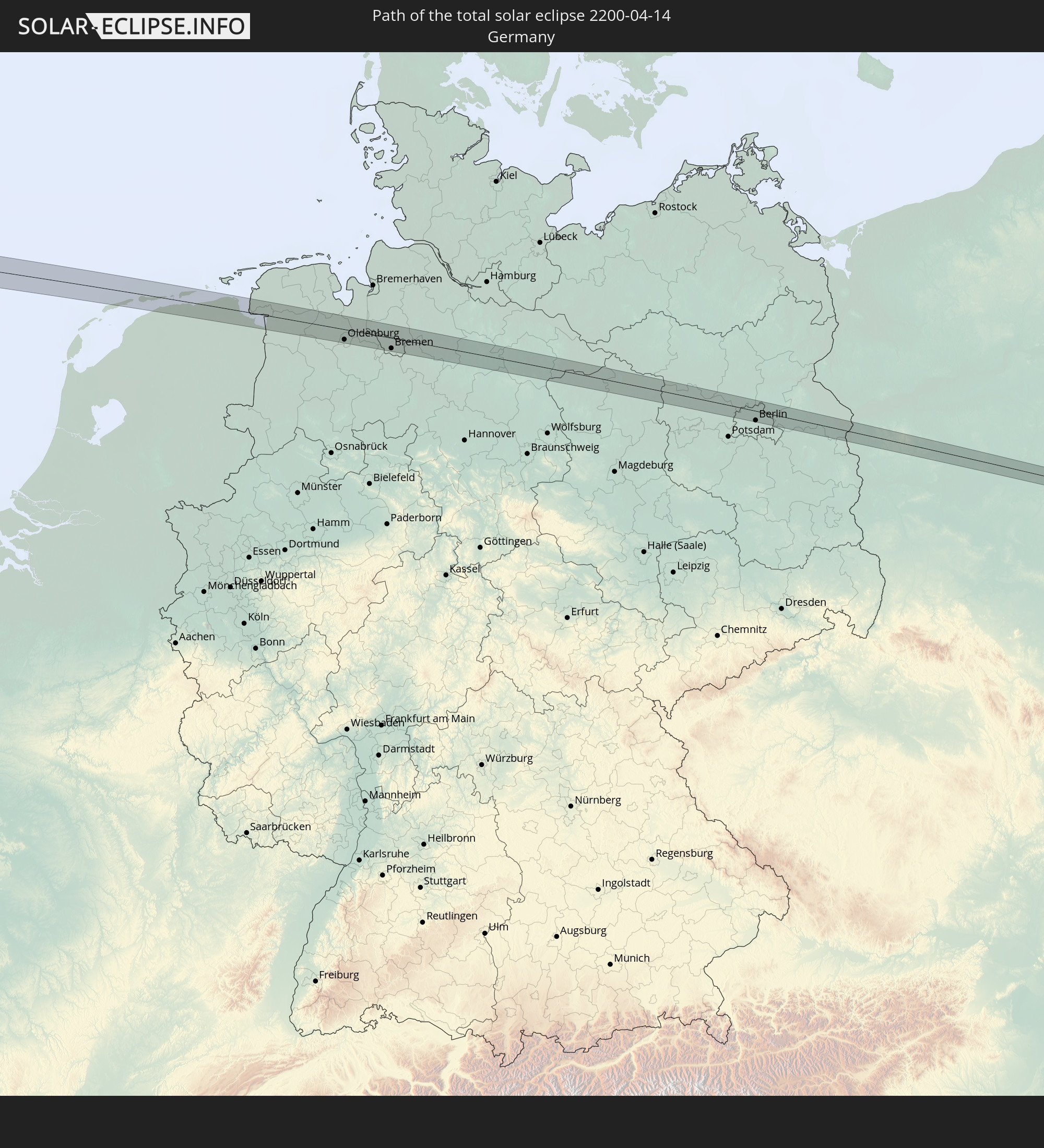 Deutschland
 Polen
Polen
 Ukraine
In den folgenden Ländern ist die Sonnenfinsternis partiell zu sehen
 Russland
 Vereinigte Staaten
 United States Minor Outlying Islands
 Kanada
 Mexiko
 Grönland
 Guatemala
 Ecuador
 El Salvador
 Honduras
 Belize
 Nicaragua
 Costa Rica
 Kuba
Kuba
 Panama
 Kolumbien
 Kaimaninseln
 Peru
Peru
 Bahamas
 Jamaika
 Haiti
Haiti
 Venezuela
 Turks- und Caicosinseln
 Dominikanische Republik
 Aruba
Aruba
 Puerto Rico
 Amerikanische Jungferninseln
 Bermuda
 Britische Jungferninseln
 Anguilla
 Saint-Martin
 Saint-Barthélemy
 St. Kitts und Nevis
 Antigua und Barbuda
 Montserrat
 Trinidad und Tobago
 Guadeloupe
 Grenada
 Dominica
 St. Vincent und die Grenadinen
 Martinique
 St. Lucia
 Barbados
 Saint-Pierre und Miquelon
 Portugal
 Island
 Spanien
 Mauretanien
 Marokko
 Mali
Mali
 Irland
 Spitzbergen
 Algerien
 Vereinigtes Königreich
 Färöer
 Gibraltar
 Frankreich
 Isle of Man
 Guernsey
 Jersey
 Niger
Niger
 Andorra
 Belgien
 Niederlande
 Norwegen
 Luxemburg
 Deutschland
 Schweiz
 Italien
 Monaco
 Tunesien
 Dänemark
 Libyen
 Liechtenstein
 Österreich
 Schweden
 Tschechien
 San Marino
 Vatikanstadt
 Slowenien
 Kroatien
 Polen
Polen
 Malta
Malta
 Bosnien und Herzegowina
 Ungarn
 Slowakei
 Montenegro
 Serbien
 Åland Islands
 Rumänien
 Finnland
 Litauen
 Lettland
 Estland
 Ukraine
 Weißrussland
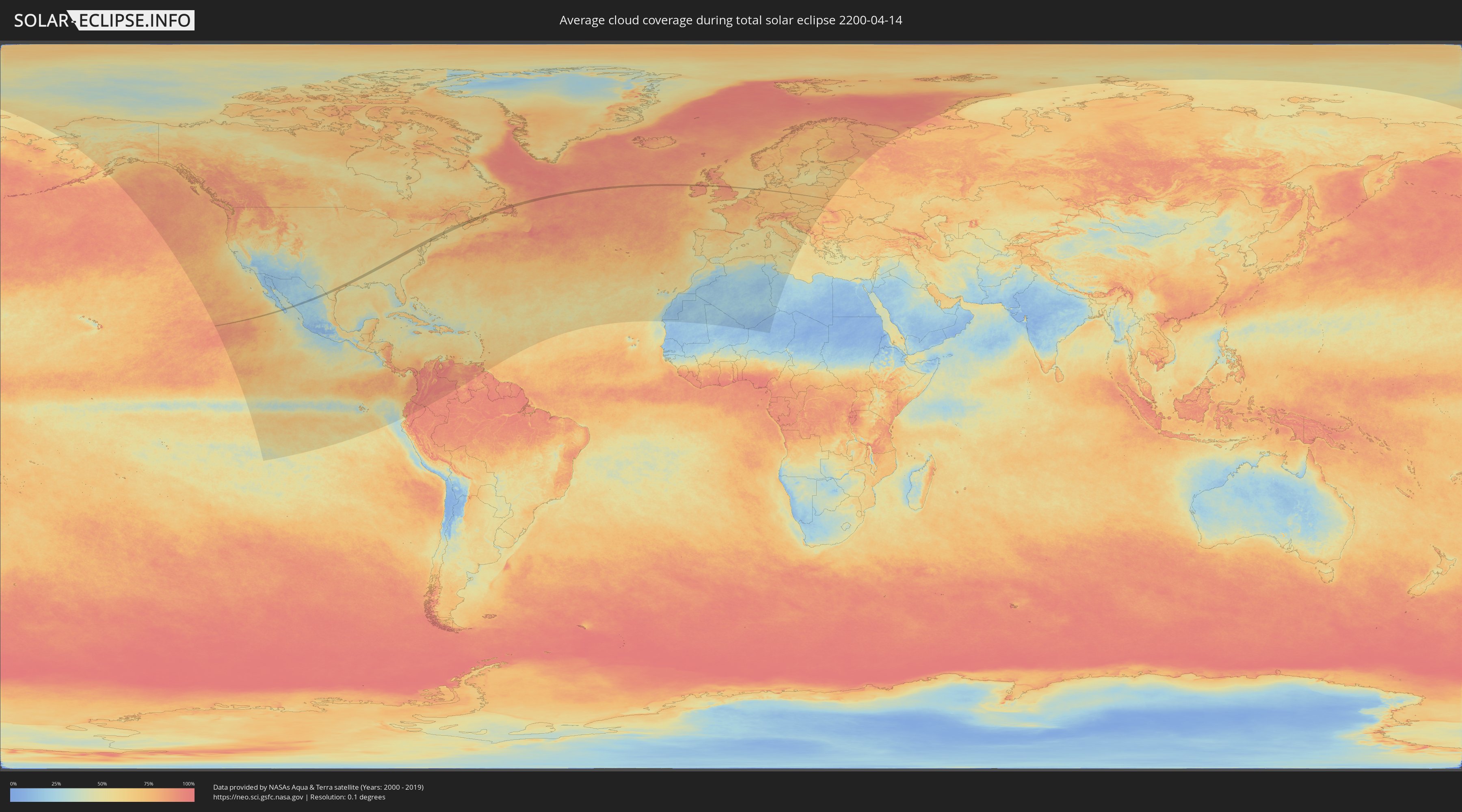
Wie wird das Wetter während der totalen Sonnenfinsternis am 14.04.2200?
Wo ist der beste Ort, um die totale Sonnenfinsternis vom 14.04.2200 zu beobachten?
Die folgenden Karten zeigen die durchschnittliche Bewölkung für den Tag, an dem die totale Sonnenfinsternis
stattfindet. Mit Hilfe der Karten lässt sich der Ort entlang des Finsternispfades eingrenzen,
der die besten Aussichen auf einen klaren wolkenfreien Himmel bietet.
Trotzdem muss man immer lokale Gegenenheiten beachten und sollte sich genau über das Wetter an seinem
gewählten Beobachtungsort informieren.
Die Daten stammen von den beiden NASA-Satelliten
AQUA und TERRA
und wurden über einen Zeitraum von 19 Jahren (2000 - 2019) gemittelt.

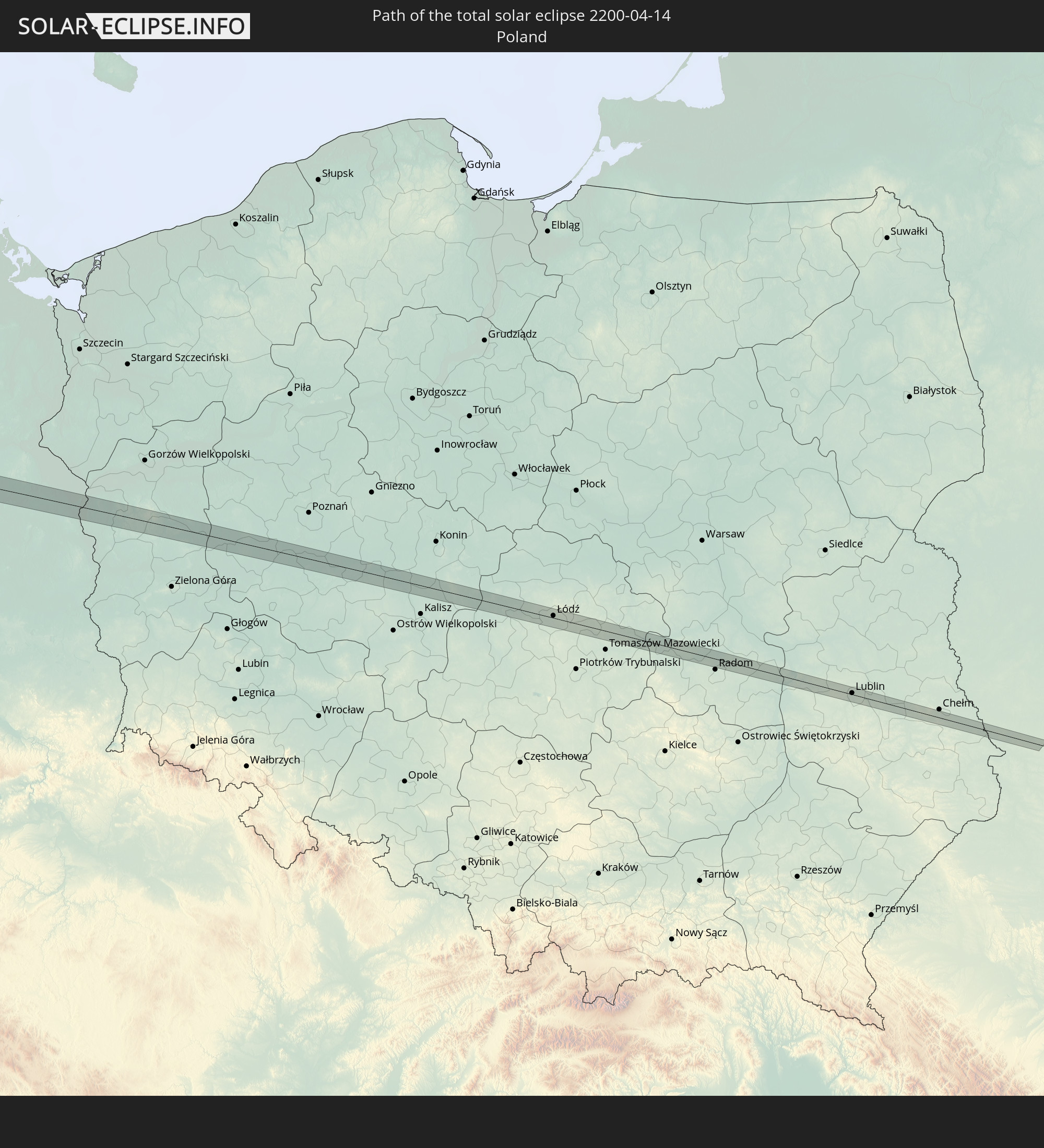
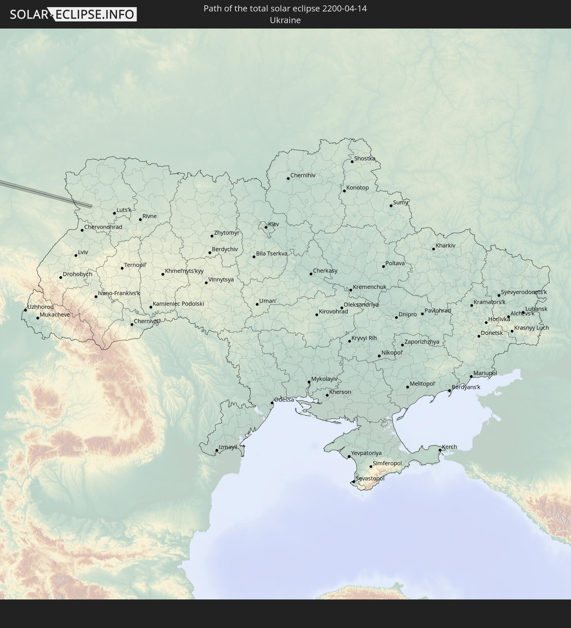
Detaillierte Länderkarten
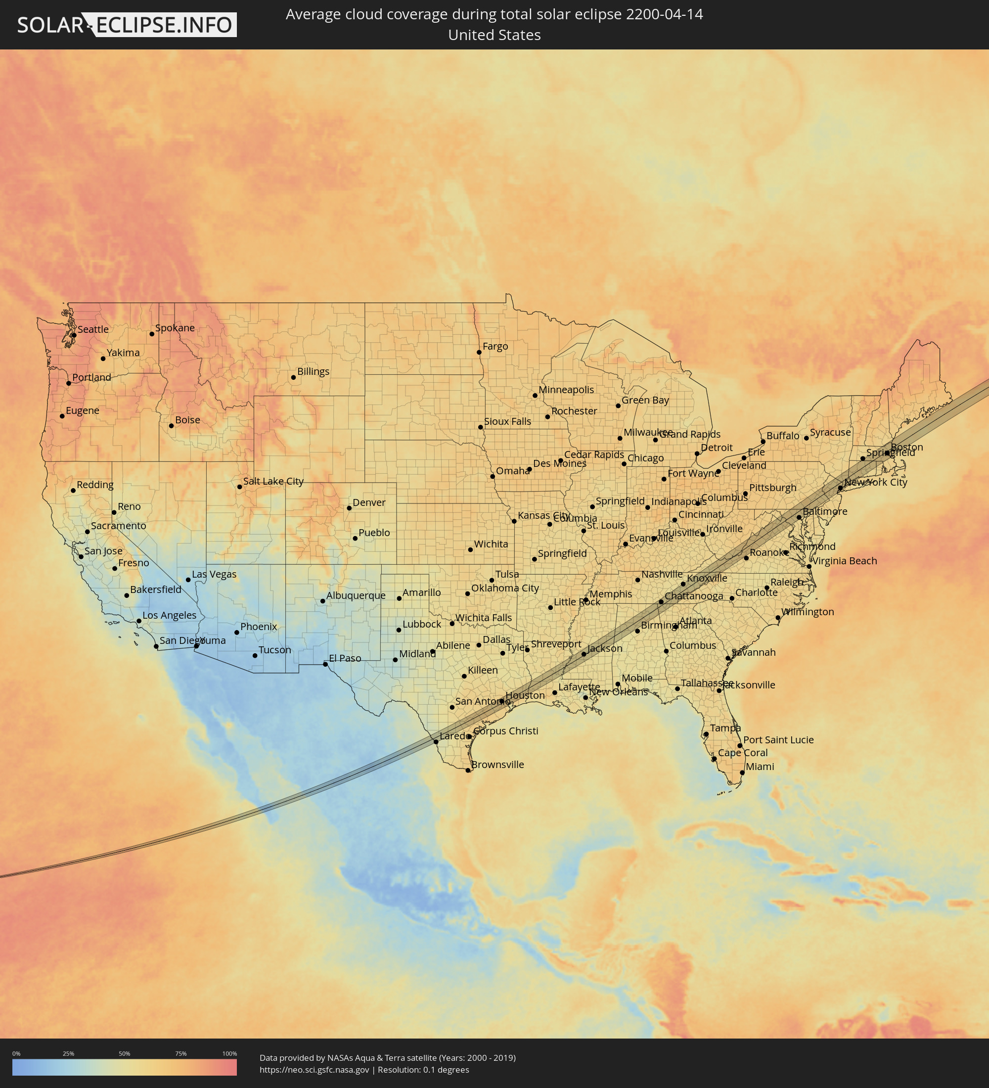 Vereinigte Staaten
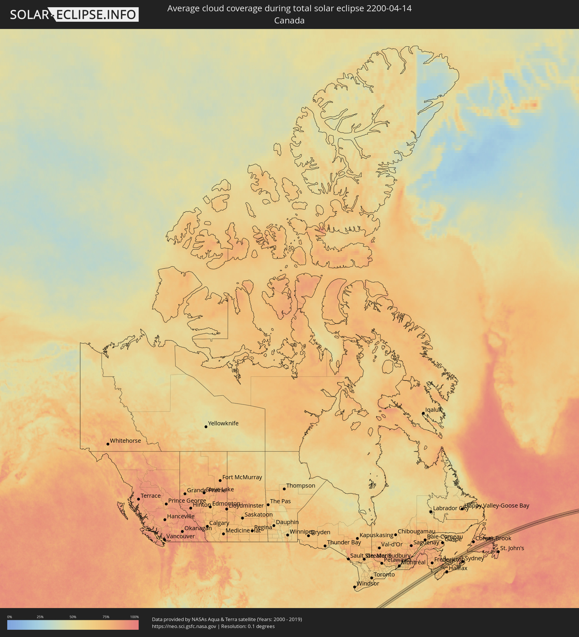 Kanada
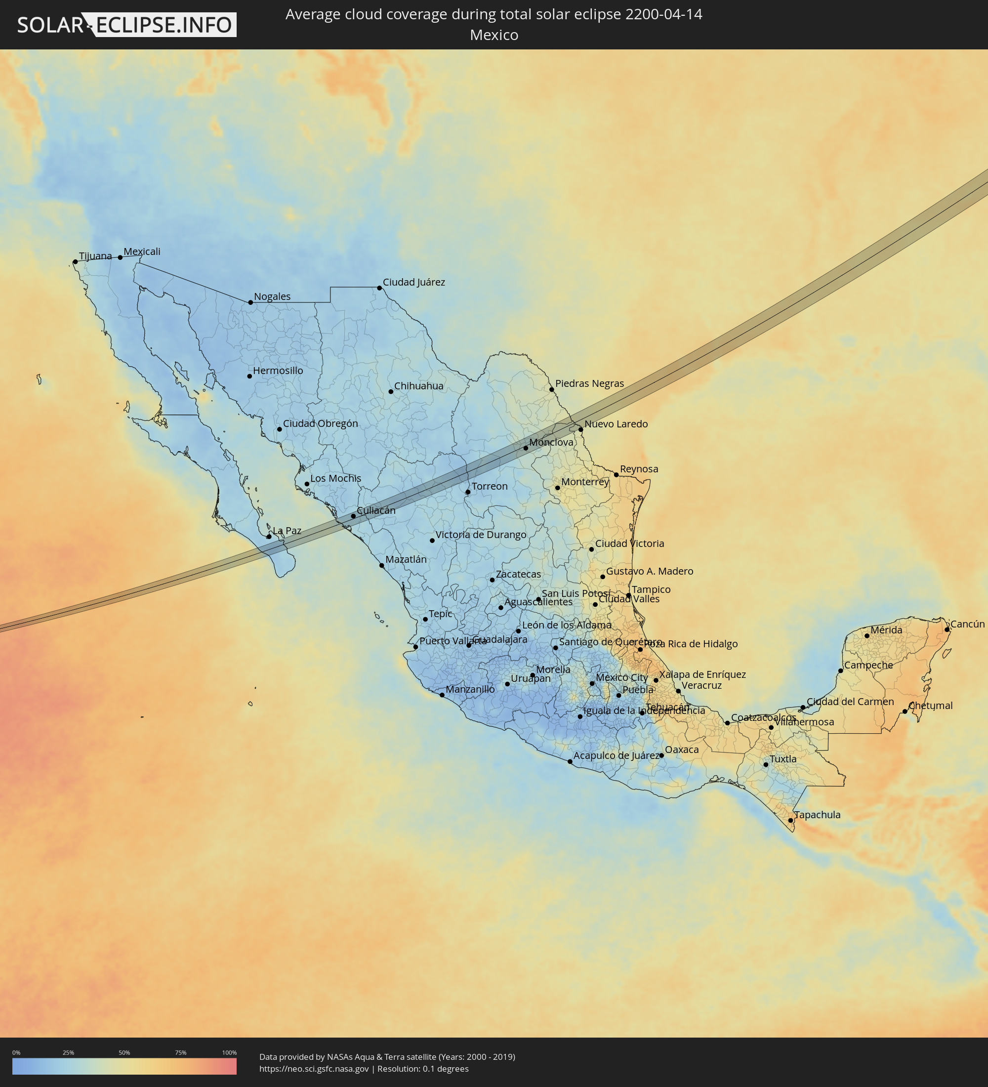 Mexiko
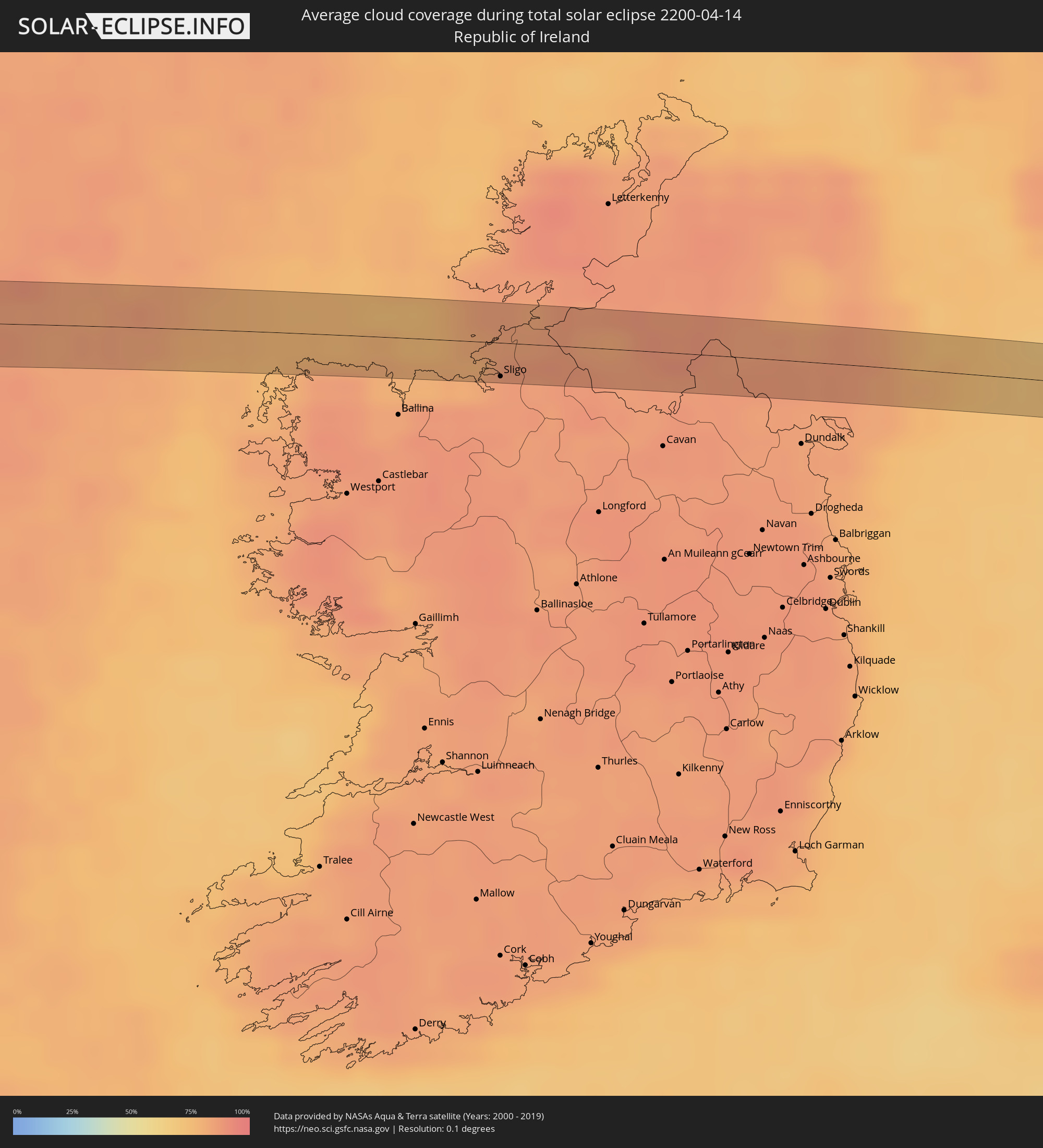 Irland
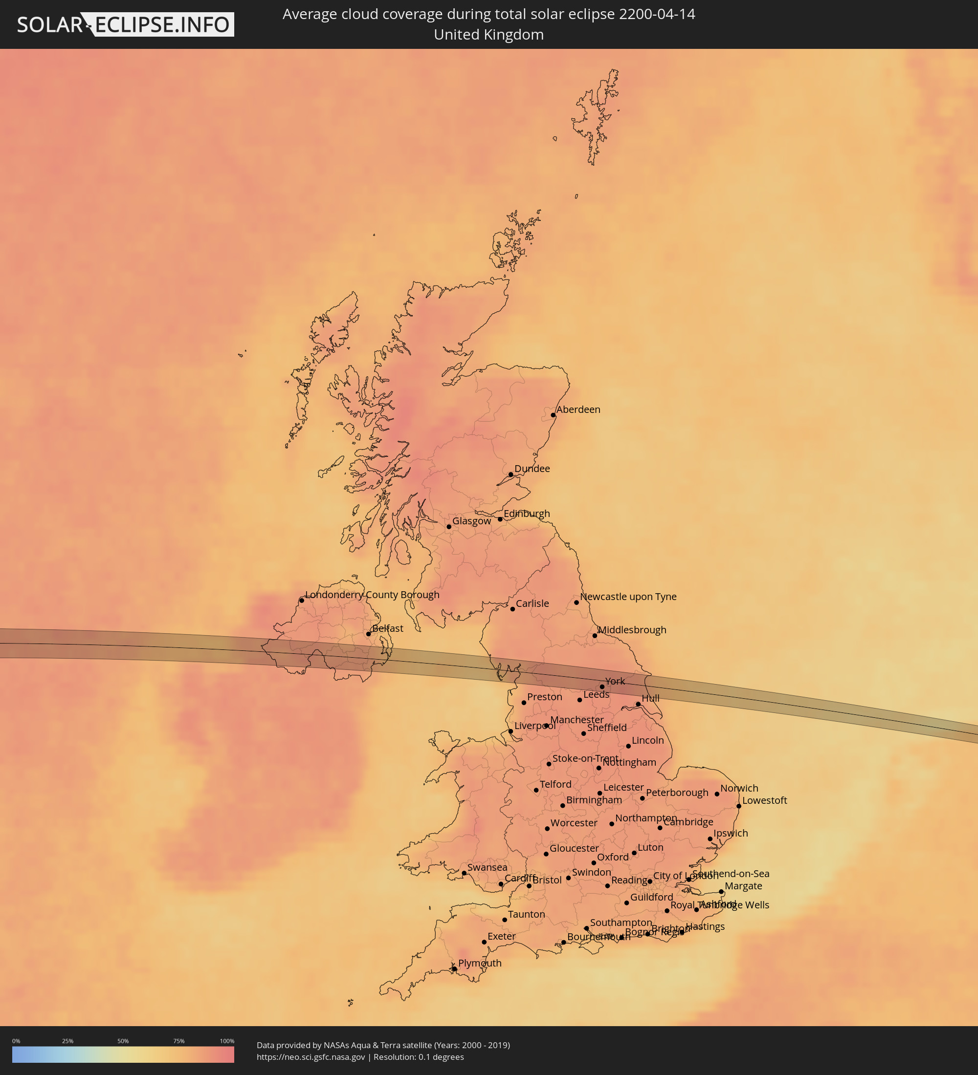 Vereinigtes Königreich
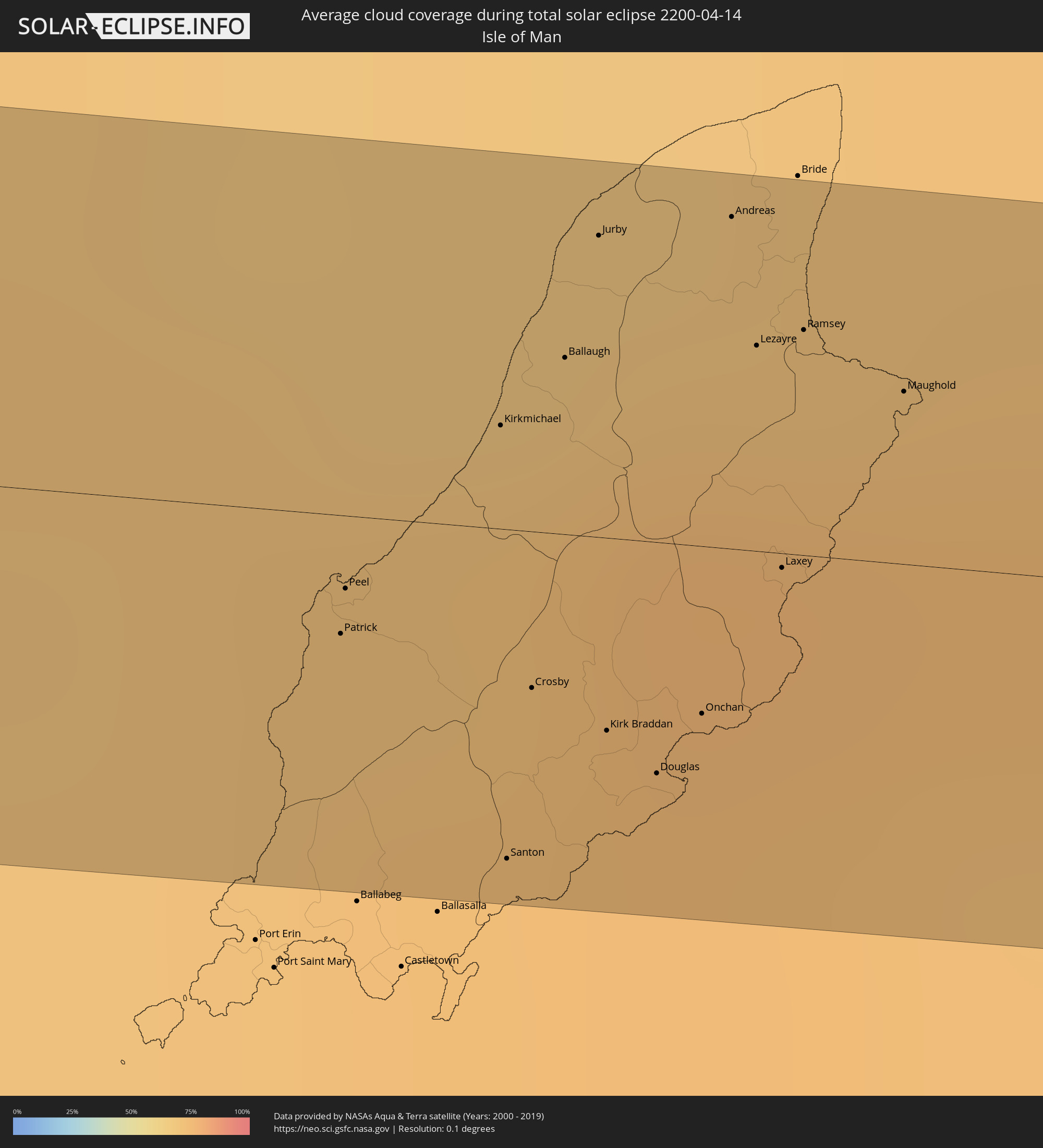 Isle of Man
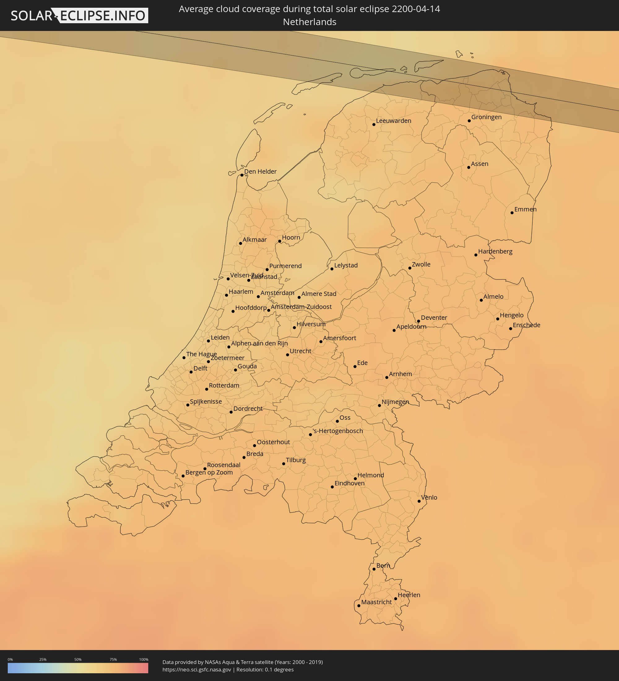 Niederlande
 Deutschland
 Polen
Polen
 Ukraine
Orte im Finsternispfad
Die nachfolgene Tabelle zeigt Städte und Orte mit mehr als 5.000 Einwohnern, die sich im Finsternispfad befinden. Städte mit mehr als 100.000 Einwohnern sind dick gekennzeichnet. Mit einem Klick auf den Ort öffnet sich eine Detailkarte die die Lage des jeweiligen Ortes zusammen mit dem Verlauf der zentralen Finsternis präsentiert.
| Ort | Typ | Dauer der Verfinsterung | Ortszeit bei maximaler Verfinsterung | Entfernung zur Zentrallinie | Ø Bewölkung |
|
Navolato, Sinaloa
|
total | - | 07:23:47 UTC-07:00 | 14 km | 25% |
|
General Ángel Flores (La Palma), Sinaloa
|
total | - | 07:23:53 UTC-07:00 | 18 km | 25% |
|
Licenciado Benito Juárez (Campo Gobierno), Sinaloa
|
total | - | 07:23:41 UTC-07:00 | 3 km | 26% |
|
Villa Juárez, Sinaloa
|
total | - | 07:23:41 UTC-07:00 | 3 km | 26% |
|
El Diez, Sinaloa
|
total | - | 07:23:50 UTC-07:00 | 1 km | 26% |
|
Villa de Costa Rica, Sinaloa
|
total | - | 07:23:39 UTC-07:00 | 15 km | 27% |
|
Culiacán, Sinaloa
|
total | - | 07:23:57 UTC-07:00 | 5 km | 24% |
|
Tlahualilo de Zaragoza, Durango
|
total | - | 08:28:03 UTC-06:00 | 9 km | 16% |
|
San Buenaventura, Coahuila
|
total | - | 08:30:49 UTC-06:00 | 11 km | 32% |
|
Ciudad Frontera, Coahuila
|
total | - | 08:30:39 UTC-06:00 | 7 km | 33% |
|
Castaños, Coahuila
|
total | - | 08:30:27 UTC-06:00 | 22 km | 31% |
|
Monclova, Coahuila
|
total | - | 08:30:39 UTC-06:00 | 10 km | 34% |
|
Houston, Texas
|
total | - | 08:40:24 UTC-06:00 | 5 km | 61% |
|
Pasadena, Texas
|
total | - | 08:40:25 UTC-06:00 | 9 km | 62% |
|
Beaumont, Texas
|
total | - | 08:42:11 UTC-06:00 | 22 km | 62% |
|
Jackson, Mississippi
|
total | - | 08:50:22 UTC-06:00 | 1 km | 54% |
|
Chattanooga, Tennessee
|
total | - | 10:01:29 UTC-05:00 | 13 km | 54% |
|
Knoxville, Tennessee
|
total | - | 10:05:03 UTC-05:00 | 27 km | 51% |
|
Columbia, Maryland
|
total | - | 10:21:28 UTC-05:00 | 26 km | 57% |
|
Baltimore, Maryland
|
total | - | 10:21:55 UTC-05:00 | 33 km | 56% |
|
Allentown, Pennsylvania
|
total | - | 10:25:54 UTC-05:00 | 34 km | 60% |
|
Edison, New Jersey
|
total | - | 10:27:32 UTC-05:00 | 26 km | 59% |
|
Paterson, New Jersey
|
total | - | 10:28:33 UTC-05:00 | 1 km | 60% |
|
Staten Island, New York
|
total | - | 10:28:03 UTC-05:00 | 35 km | 58% |
|
New York City, New York
|
total | - | 10:28:31 UTC-05:00 | 28 km | 62% |
|
The Bronx, New York
|
total | - | 10:28:57 UTC-05:00 | 22 km | 61% |
|
Stamford, Connecticut
|
total | - | 10:29:49 UTC-05:00 | 18 km | 58% |
|
Bridgeport, Connecticut
|
total | - | 10:30:33 UTC-05:00 | 24 km | 56% |
|
Waterbury, Connecticut
|
total | - | 10:31:25 UTC-05:00 | 5 km | 58% |
|
New Haven, Connecticut
|
total | - | 10:31:14 UTC-05:00 | 24 km | 59% |
|
Hartford, Connecticut
|
total | - | 10:32:20 UTC-05:00 | 7 km | 59% |
|
Springfield, Massachusetts
|
total | - | 10:33:00 UTC-05:00 | 34 km | 57% |
|
Worcester, Massachusetts
|
total | - | 10:34:34 UTC-05:00 | 13 km | 60% |
|
Lowell, Massachusetts
|
total | - | 10:35:55 UTC-05:00 | 25 km | 58% |
|
Boston, Massachusetts
|
total | - | 10:35:57 UTC-05:00 | 12 km | 62% |
|
Greenwood, Nova Scotia
|
total | - | 11:49:54 UTC-04:00 | 30 km | 72% |
|
Amherst, Nova Scotia
|
total | - | 11:52:06 UTC-04:00 | 22 km | 75% |
|
Charlottetown, Prince Edward Island
|
total | - | 11:54:21 UTC-04:00 | 20 km | 70% |
|
Grand Falls-Windsor, Newfoundland and Labrador
|
total | - | 12:38:58 UTC-03:30 | 21 km | 87% |
|
Sligo, Connaught
|
total | - | 17:00:40 UTC+00:00 | 15 km | 84% |
|
Enniskillen, Northern Ireland
|
total | - | 17:01:00 UTC+00:00 | 3 km | 85% |
|
Monaghan, Ulster
|
total | - | 17:01:28 UTC+00:00 | 11 km | 87% |
|
Armagh, Northern Ireland
|
total | - | 17:01:29 UTC+00:00 | 1 km | 86% |
|
Craigavon, Northern Ireland
|
total | - | 17:01:30 UTC+00:00 | 13 km | 85% |
|
Newry, Northern Ireland
|
total | - | 17:01:51 UTC+00:00 | 16 km | 84% |
|
Banbridge, Northern Ireland
|
total | - | 17:01:40 UTC+00:00 | 3 km | 85% |
|
Newcastle, Northern Ireland
|
total | - | 17:02:01 UTC+00:00 | 10 km | 82% |
|
Downpatrick, Northern Ireland
|
total | - | 17:01:58 UTC+00:00 | 3 km | 79% |
|
Patrick, Patrick
|
total | - | 17:02:34 UTC+00:00 | 5 km | 72% |
|
Peel, Peel
|
total | - | 17:02:33 UTC+00:00 | 3 km | 72% |
|
Kirkmichael, Michael
|
total | - | 17:02:31 UTC+00:00 | 4 km | 72% |
|
Santon, Santon
|
total | - | 17:02:43 UTC+00:00 | 14 km | 73% |
|
Crosby, Marown
|
total | - | 17:02:39 UTC+00:00 | 7 km | 73% |
|
Ballaugh, Ballaugh
|
total | - | 17:02:30 UTC+00:00 | 8 km | 75% |
|
Jurby, Jurby
|
total | - | 17:02:27 UTC+00:00 | 13 km | 70% |
|
Kirk Braddan, Braddan
|
total | - | 17:02:42 UTC+00:00 | 8 km | 74% |
|
Douglas, Douglas
|
total | - | 17:02:44 UTC+00:00 | 10 km | 74% |
|
Onchan, Onchan
|
total | - | 17:02:43 UTC+00:00 | 7 km | 74% |
|
Andreas, Andreas
|
total | - | 17:02:29 UTC+00:00 | 14 km | 70% |
|
Lezayre, Lezayre
|
total | - | 17:02:33 UTC+00:00 | 9 km | 75% |
|
Laxey, Laxey
|
total | - | 17:02:40 UTC+00:00 | 1 km | 74% |
|
Ramsey, Ramsey
|
total | - | 17:02:34 UTC+00:00 | 10 km | 75% |
|
Maughold, Maughold
|
total | - | 17:02:37 UTC+00:00 | 7 km | 74% |
|
Barrow in Furness, England
|
total | - | 17:03:18 UTC+00:00 | 7 km | 73% |
|
Dalton in Furness, England
|
total | - | 17:03:17 UTC+00:00 | 2 km | 74% |
|
Ulverston, England
|
total | - | 17:03:15 UTC+00:00 | 3 km | 78% |
|
Morecambe, England
|
total | - | 17:03:30 UTC+00:00 | 9 km | 76% |
|
Bolton le Sands, England
|
total | - | 17:03:31 UTC+00:00 | 7 km | 79% |
|
Harrogate, England
|
total | - | 17:04:06 UTC+00:00 | 9 km | 88% |
|
Ripon, England
|
total | - | 17:03:55 UTC+00:00 | 7 km | 88% |
|
Knaresborough, England
|
total | - | 17:04:06 UTC+00:00 | 6 km | 88% |
|
Wetherby, England
|
total | - | 17:04:14 UTC+00:00 | 15 km | 89% |
|
York, England
|
total | - | 17:04:18 UTC+00:00 | 9 km | 88% |
|
Haxby, England
|
total | - | 17:04:14 UTC+00:00 | 3 km | 88% |
|
Pocklington, England
|
total | - | 17:04:26 UTC+00:00 | 9 km | 89% |
|
Watton, England
|
total | - | 17:04:33 UTC+00:00 | 7 km | 89% |
|
Driffield, England
|
total | - | 17:04:27 UTC+00:00 | 1 km | 87% |
|
Bridlington, England
|
total | - | 17:04:27 UTC+00:00 | 12 km | 83% |
|
Hornsea, England
|
total | - | 17:04:40 UTC+00:00 | 7 km | 86% |
|
Ulrum, Groningen
|
total | - | 18:07:02 UTC+01:00 | 6 km | 71% |
|
Winsum, Groningen
|
total | - | 18:07:06 UTC+01:00 | 7 km | 72% |
|
Bedum, Groningen
|
total | - | 18:07:09 UTC+01:00 | 10 km | 72% |
|
Appingedam, Groningen
|
total | - | 18:07:10 UTC+01:00 | 5 km | 71% |
|
Delfzijl, Groningen
|
total | - | 18:07:10 UTC+01:00 | 3 km | 71% |
|
Emden, Lower Saxony
|
total | - | 18:07:11 UTC+01:00 | 4 km | 73% |
|
Leer, Lower Saxony
|
total | - | 18:07:23 UTC+01:00 | 8 km | 72% |
|
Mittegroßefehn, Lower Saxony
|
total | - | 18:07:12 UTC+01:00 | 11 km | 73% |
|
Bad Zwischenahn, Lower Saxony
|
total | - | 18:07:32 UTC+01:00 | 6 km | 71% |
|
Oldenburg, Lower Saxony
|
total | - | 18:07:37 UTC+01:00 | 9 km | 73% |
|
Elsfleth, Lower Saxony
|
total | - | 18:07:32 UTC+01:00 | 5 km | 72% |
|
Hude, Lower Saxony
|
total | - | 18:07:41 UTC+01:00 | 9 km | 71% |
|
Osterholz-Scharmbeck, Lower Saxony
|
total | - | 18:07:35 UTC+01:00 | 8 km | 69% |
|
Bremen, Bremen
|
total | - | 18:07:47 UTC+01:00 | 9 km | 70% |
|
Worpswede, Lower Saxony
|
total | - | 18:07:37 UTC+01:00 | 8 km | 69% |
|
Ottersberg, Lower Saxony
|
total | - | 18:07:47 UTC+01:00 | 1 km | 68% |
|
Rotenburg, Lower Saxony
|
total | - | 18:07:48 UTC+01:00 | 3 km | 68% |
|
Visselhövede, Lower Saxony
|
total | - | 18:07:59 UTC+01:00 | 9 km | 68% |
|
Soltau, Lower Saxony
|
total | - | 18:08:01 UTC+01:00 | 5 km | 68% |
|
Munster, Lower Saxony
|
total | - | 18:08:02 UTC+01:00 | 2 km | 67% |
|
Uelzen, Lower Saxony
|
total | - | 18:08:06 UTC+01:00 | 1 km | 69% |
|
Salzwedel, Saxony-Anhalt
|
total | - | 18:08:18 UTC+01:00 | 3 km | 71% |
|
Nauen, Brandenburg
|
total | - | 18:08:42 UTC+01:00 | 7 km | 71% |
|
Falkensee, Brandenburg
|
total | - | 18:08:46 UTC+01:00 | 9 km | 69% |
|
Hohen Neuendorf, Brandenburg
|
total | - | 18:08:38 UTC+01:00 | 7 km | 67% |
|
Glienicke, Brandenburg
|
total | - | 18:08:41 UTC+01:00 | 3 km | 69% |
|
Berlin, Berlin
|
total | - | 18:08:50 UTC+01:00 | 8 km | 67% |
|
Strausberg, Brandenburg
|
total | - | 18:08:46 UTC+01:00 | 5 km | 68% |
|
Rzepin, Lubusz
|
total | - | 18:09:04 UTC+01:00 | 7 km | 69% |
|
Sulęcin, Lesser Poland Voivodeship
|
total | - | 18:08:57 UTC+01:00 | 8 km | 70% |
|
Świebodzin, Lubusz
|
total | - | 18:09:11 UTC+01:00 | 7 km | 70% |
|
Zbąszynek, Lubusz
|
total | - | 18:09:11 UTC+01:00 | 3 km | 67% |
|
Zbąszyń, Greater Poland Voivodeship
|
total | - | 18:09:10 UTC+01:00 | 1 km | 66% |
|
Grodzisk Wielkopolski, Greater Poland Voivodeship
|
total | - | 18:09:11 UTC+01:00 | 4 km | 69% |
|
Kościan, Greater Poland Voivodeship
|
total | - | 18:09:21 UTC+01:00 | 7 km | 68% |
|
Czempiń, Greater Poland Voivodeship
|
total | - | 18:09:17 UTC+01:00 | 1 km | 70% |
|
Śrem, Greater Poland Voivodeship
|
total | - | 18:09:20 UTC+01:00 | 1 km | 68% |
|
Jarocin, Greater Poland Voivodeship
|
total | - | 18:09:27 UTC+01:00 | 6 km | 69% |
|
Aleksandrów Łódzki, Łódź Voivodeship
|
total | - | 18:09:30 UTC+01:00 | 6 km | 65% |
|
Konstantynów Łódzki, Łódź Voivodeship
|
total | - | 18:09:35 UTC+01:00 | 1 km | 66% |
|
Łódź, Łódź Voivodeship
|
total | - | 18:09:34 UTC+01:00 | 2 km | 65% |
|
Koluszki, Łódź Voivodeship
|
total | - | 18:09:33 UTC+01:00 | 6 km | 63% |
|
Pionki, Masovian Voivodeship
|
total | - | 18:09:40 UTC+01:00 | 6 km | 71% |
|
Zwoleń, Masovian Voivodeship
|
total | - | 18:09:47 UTC+01:00 | 5 km | 70% |
|
Lublin, Lublin Voivodeship
|
total | - | 18:09:46 UTC+01:00 | 1 km | 70% |
|
Świdnik, Lublin Voivodeship
|
total | - | 18:09:47 UTC+01:00 | 0 km | 71% |