Totale Sonnenfinsternis vom 28.08.2231
| Wochentag: | Sonntag |
| Maximale Dauer der Verfinsterung: | 04m43s |
| Maximale Breite des Finsternispfades: | 402 km |
| Saroszyklus: | 158 |
| Bedeckungsgrad: | 100% |
| Magnitude: | 1.0661 |
| Gamma: | -0.8506 |
Wo kann man die Sonnenfinsternis vom 28.08.2231 sehen?

Die Sonnenfinsternis am 28.08.2231 kann man in 20 Ländern als partielle Sonnenfinsternis beobachten.
Der Finsternispfad verläuft durch 5 Länder. Nur in diesen Ländern ist sie als totale Sonnenfinsternis zu sehen.
In den folgenden Ländern ist die Sonnenfinsternis total zu sehen
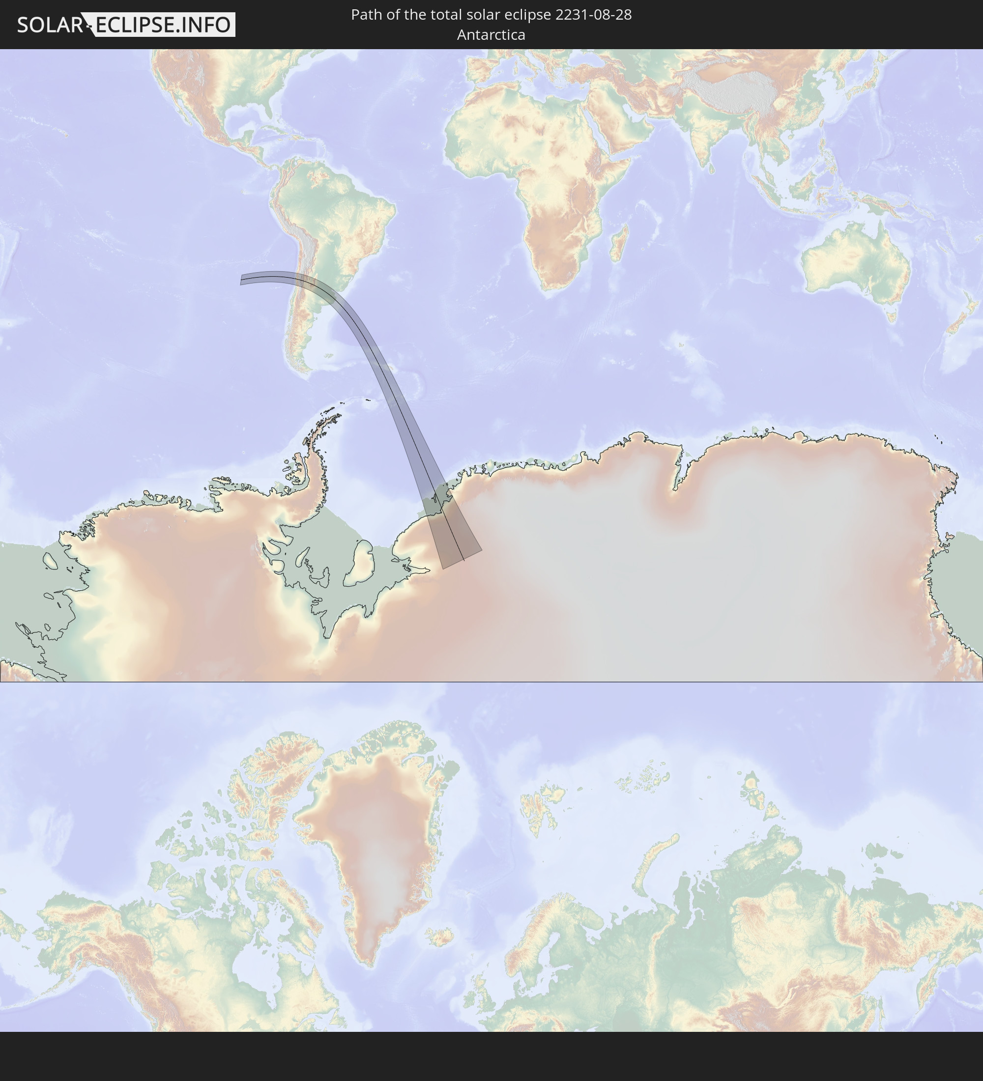 Antarktika
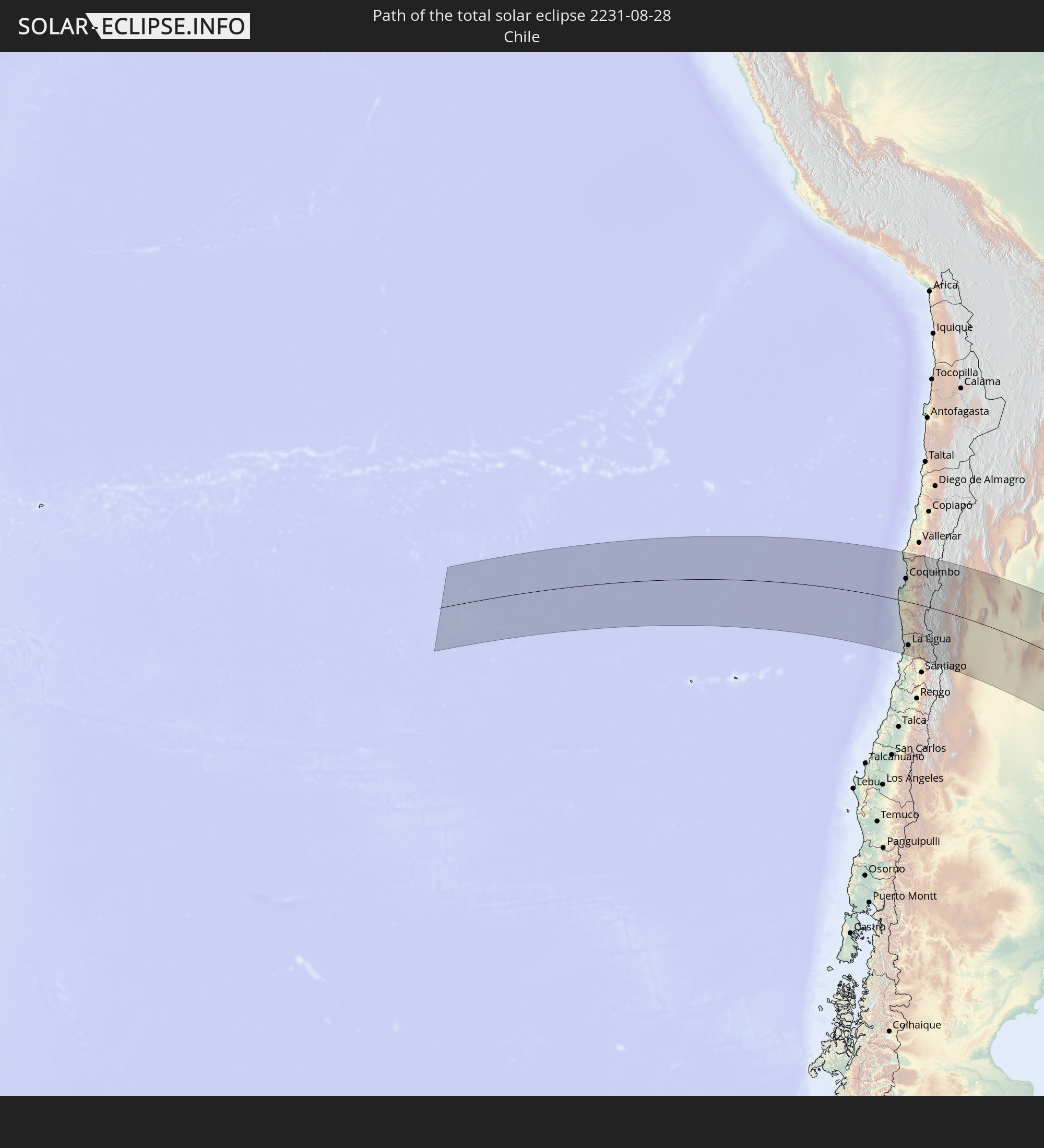 Chile
Chile
 Argentinien
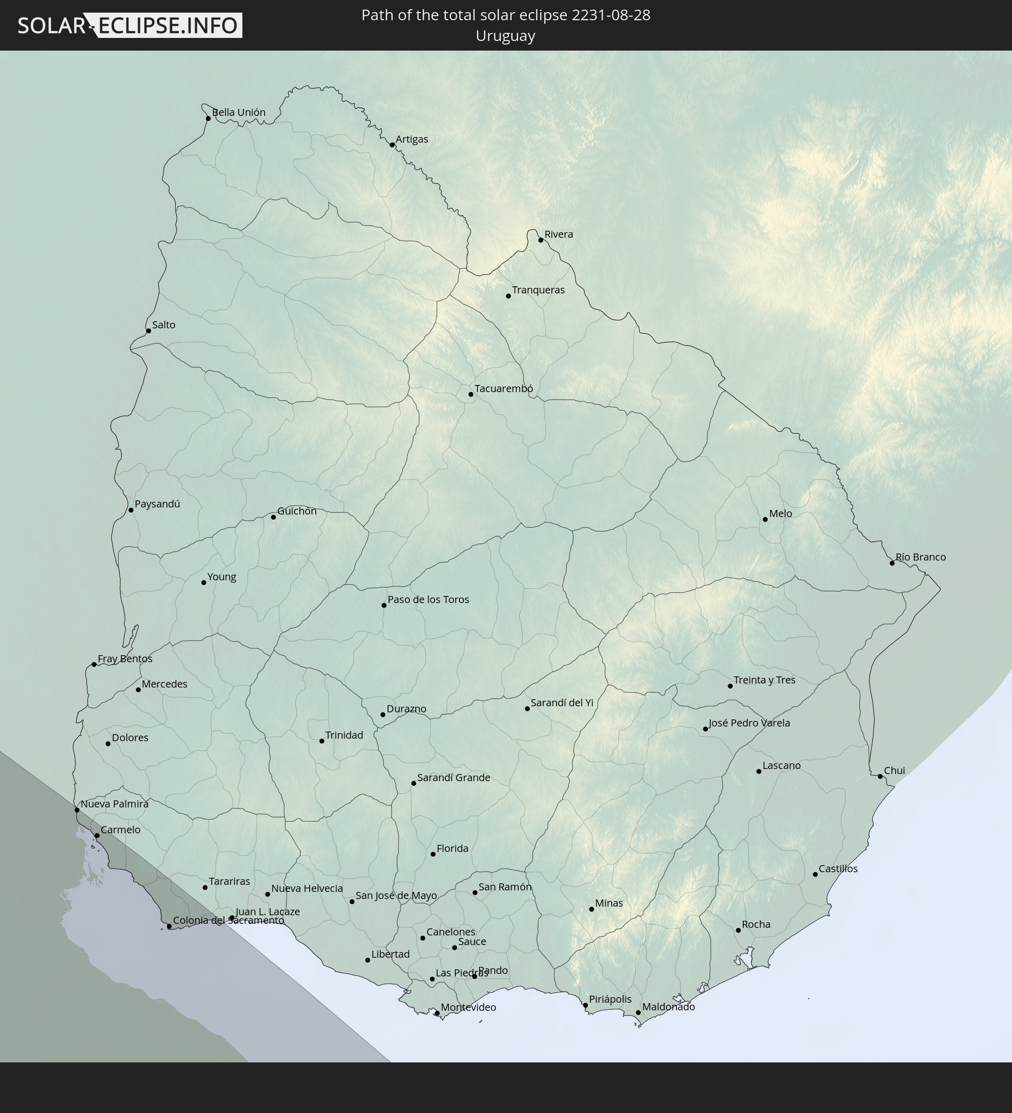 Uruguay
 Südgeorgien und die Südlichen Sandwichinseln
In den folgenden Ländern ist die Sonnenfinsternis partiell zu sehen


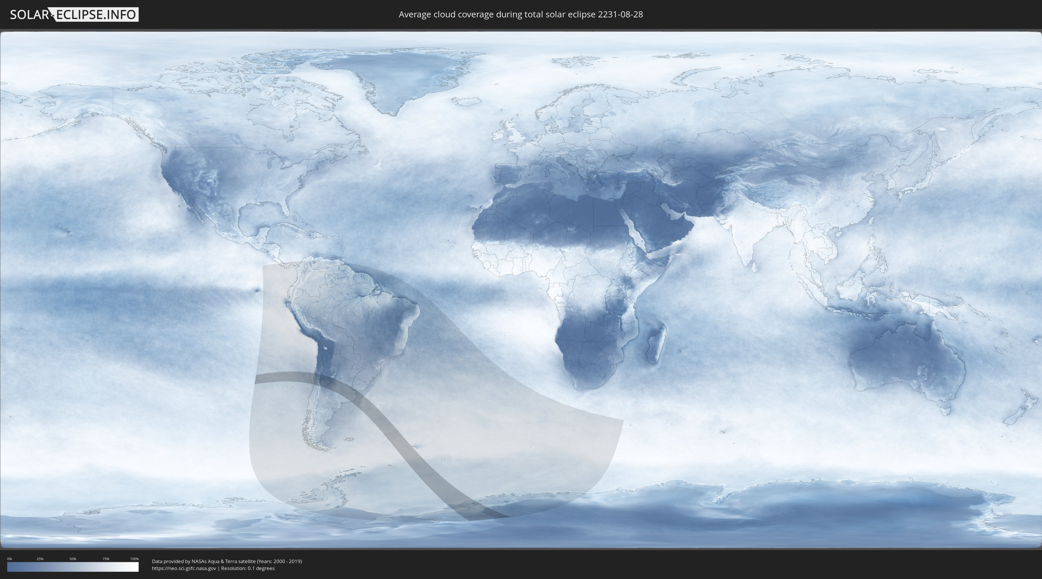
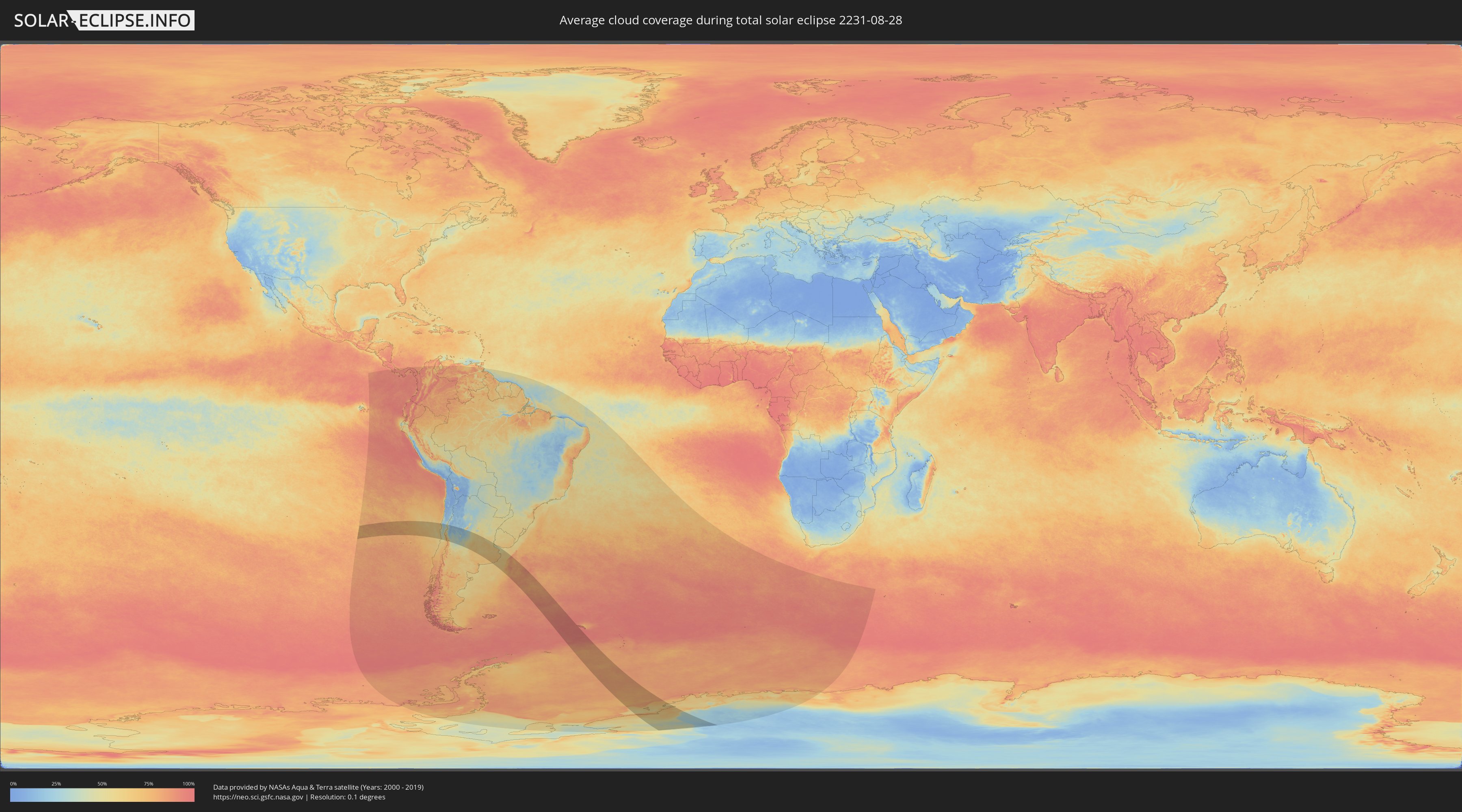
Wie wird das Wetter während der totalen Sonnenfinsternis am 28.08.2231?
Wo ist der beste Ort, um die totale Sonnenfinsternis vom 28.08.2231 zu beobachten?
Die folgenden Karten zeigen die durchschnittliche Bewölkung für den Tag, an dem die totale Sonnenfinsternis
stattfindet. Mit Hilfe der Karten lässt sich der Ort entlang des Finsternispfades eingrenzen,
der die besten Aussichen auf einen klaren wolkenfreien Himmel bietet.
Trotzdem muss man immer lokale Gegenenheiten beachten und sollte sich genau über das Wetter an seinem
gewählten Beobachtungsort informieren.
Die Daten stammen von den beiden NASA-Satelliten
AQUA und TERRA
und wurden über einen Zeitraum von 19 Jahren (2000 - 2019) gemittelt.
Detaillierte Länderkarten
 Antarktika
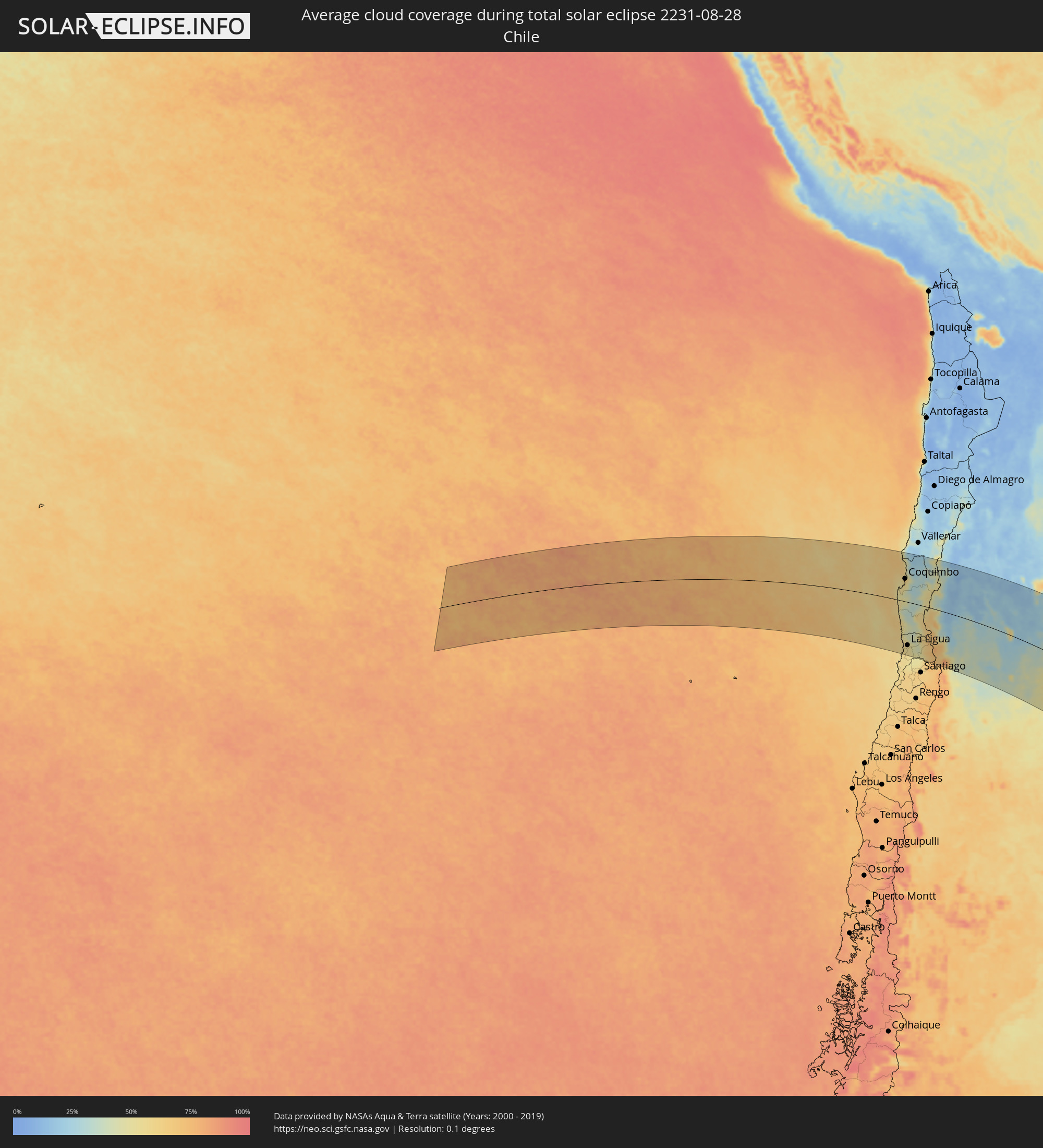 Chile
Chile
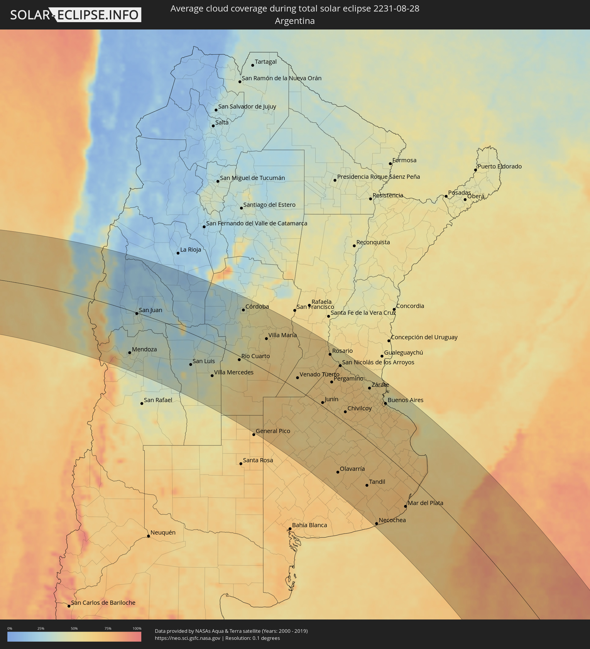 Argentinien
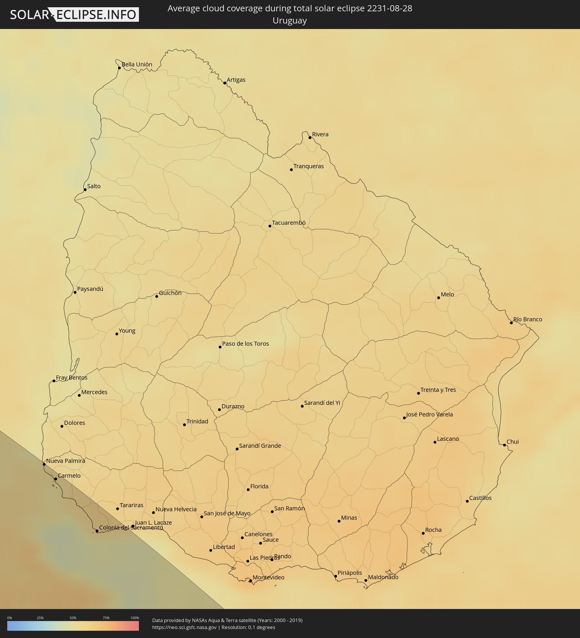 Uruguay
 Südgeorgien und die Südlichen Sandwichinseln
Orte im Finsternispfad
Die nachfolgene Tabelle zeigt Städte und Orte mit mehr als 5.000 Einwohnern, die sich im Finsternispfad befinden. Städte mit mehr als 100.000 Einwohnern sind dick gekennzeichnet. Mit einem Klick auf den Ort öffnet sich eine Detailkarte die die Lage des jeweiligen Ortes zusammen mit dem Verlauf der zentralen Finsternis präsentiert.
| Ort | Typ | Dauer der Verfinsterung | Ortszeit bei maximaler Verfinsterung | Entfernung zur Zentrallinie | Ø Bewölkung |
 Coquimbo, Coquimbo
|
total | - | 09:43:31 UTC-03:00 | 93 km | 58% |
|
La Serena, Coquimbo
|
total | - | 09:43:31 UTC-03:00 | 101 km | 58% |
|
La Ligua, Valparaíso
|
total | - | 09:47:58 UTC-03:00 | 174 km | 54% |
|
Hacienda La Calera, Valparaíso
|
total | - | 09:48:34 UTC-03:00 | 210 km | 54% |
|
Ovalle, Coquimbo
|
total | - | 09:44:46 UTC-03:00 | 26 km | 45% |
|
Illapel, Coquimbo
|
total | - | 09:46:36 UTC-03:00 | 85 km | 45% |
|
Salamanca, Coquimbo
|
total | - | 09:47:03 UTC-03:00 | 96 km | 41% |
|
Monte Patria, Coquimbo
|
total | - | 09:45:10 UTC-03:00 | 21 km | 36% |
|
Llaillay, Valparaíso
|
total | - | 09:48:55 UTC-03:00 | 210 km | 50% |
|
San Felipe, Valparaíso
|
total | - | 09:48:59 UTC-03:00 | 194 km | 48% |
|
Vicuña, Coquimbo
|
total | - | 09:44:16 UTC-03:00 | 98 km | 30% |
|
Los Andes, Valparaíso
|
total | - | 09:49:16 UTC-03:00 | 200 km | 51% |
 Mendoza, Mendoza Province
|
total | - | 09:51:11 UTC-03:00 | 155 km | 46% |
|
San José de Jáchal, San Juan Province
|
total | - | 09:46:36 UTC-03:00 | 127 km | 21% |
|
Pocito, San Juan Province
|
total | - | 09:49:18 UTC-03:00 | 21 km | 34% |
|
San Juan, San Juan Province
|
total | - | 09:49:06 UTC-03:00 | 4 km | 37% |
|
San Martín, Mendoza Province
|
total | - | 09:51:54 UTC-03:00 | 164 km | 36% |
|
Caucete, San Juan Province
|
total | - | 09:49:34 UTC-03:00 | 8 km | 35% |
|
San Luis, San Luis Province
|
total | - | 09:54:37 UTC-03:00 | 110 km | 38% |
|
Chamical, La Rioja Province
|
total | - | 09:49:27 UTC-03:00 | 192 km | 17% |
|
La Punta, San Luis Province
|
total | - | 09:54:27 UTC-03:00 | 98 km | 36% |
|
Villa Mercedes, San Luis Province
|
total | - | 09:56:18 UTC-03:00 | 114 km | 47% |
|
Villa Dolores, Cordoba Province
|
total | - | 09:53:32 UTC-03:00 | 71 km | 29% |
|
Cruz del Eje, Cordoba Province
|
total | - | 09:51:50 UTC-03:00 | 210 km | 29% |
|
Villa Carlos Paz, Cordoba Province
|
total | - | 09:53:26 UTC-03:00 | 151 km | 34% |
|
La Falda, Cordoba Province
|
total | - | 09:52:51 UTC-03:00 | 185 km | 34% |
|
Cosquín, Cordoba Province
|
total | - | 09:53:09 UTC-03:00 | 171 km | 31% |
|
Alta Gracia, Cordoba Province
|
total | - | 09:53:55 UTC-03:00 | 131 km | 39% |
|
Embalse, Cordoba Province
|
total | - | 09:54:52 UTC-03:00 | 79 km | 39% |
|
Río Cuarto, Cordoba Province
|
total | - | 09:56:38 UTC-03:00 | 13 km | 53% |
|
La Calera, Cordoba Province
|
total | - | 09:53:29 UTC-03:00 | 166 km | 42% |
|
Río Ceballos, Cordoba Province
|
total | - | 09:53:11 UTC-03:00 | 184 km | 37% |
|
Córdoba, Cordoba Province
|
total | - | 09:53:47 UTC-03:00 | 165 km | 46% |
|
Río Tercero, Cordoba Province
|
total | - | 09:55:13 UTC-03:00 | 92 km | 47% |
|
Jesús María, Cordoba Province
|
total | - | 09:53:08 UTC-03:00 | 212 km | 43% |
|
Río Segundo, Cordoba Province
|
total | - | 09:54:32 UTC-03:00 | 152 km | 52% |
|
Oncativo, Cordoba Province
|
total | - | 09:55:17 UTC-03:00 | 136 km | 51% |
|
Laboulaye, Cordoba Province
|
total | - | 09:59:33 UTC-03:00 | 67 km | 64% |
|
Villa María, Cordoba Province
|
total | - | 09:56:42 UTC-03:00 | 107 km | 56% |
|
Arroyito, Cordoba Province
|
total | - | 09:55:11 UTC-03:00 | 212 km | 55% |
|
Las Varillas, Cordoba Province
|
total | - | 09:56:23 UTC-03:00 | 183 km | 56% |
|
Rufino, Santa Fe Province
|
total | - | 10:00:39 UTC-03:00 | 48 km | 64% |
|
Bell Ville, Cordoba Province
|
total | - | 09:57:46 UTC-03:00 | 110 km | 59% |
|
Marcos Juárez, Cordoba Province
|
total | - | 09:58:37 UTC-03:00 | 131 km | 56% |
|
Venado Tuerto, Santa Fe Province
|
total | - | 10:00:39 UTC-03:00 | 37 km | 58% |
|
Las Rosas, Santa Fe Province
|
total | - | 09:58:53 UTC-03:00 | 177 km | 60% |
|
Lincoln, Buenos Aires
|
total | - | 10:03:11 UTC-03:00 | 45 km | 60% |
|
Firmat, Santa Fe Province
|
total | - | 10:00:45 UTC-03:00 | 88 km | 60% |
|
Cañada de Gómez, Santa Fe Province
|
total | - | 09:59:44 UTC-03:00 | 153 km | 60% |
|
Casilda, Santa Fe Province
|
total | - | 10:00:25 UTC-03:00 | 143 km | 59% |
|
Carcarañá, Santa Fe Province
|
total | - | 10:00:06 UTC-03:00 | 161 km | 61% |
|
Junín, Buenos Aires
|
total | - | 10:03:26 UTC-03:00 | 11 km | 64% |
|
Nueve de Julio, Buenos Aires
|
total | - | 10:05:02 UTC-03:00 | 64 km | 64% |
|
Funes, Santa Fe Province
|
total | - | 10:00:39 UTC-03:00 | 173 km | 63% |
|
Fray Luis A. Beltrán, Santa Fe Province
|
total | - | 10:00:32 UTC-03:00 | 189 km | 59% |
|
Capitán Bermúdez, Santa Fe Province
|
total | - | 10:00:36 UTC-03:00 | 186 km | 59% |
|
Rosario, Santa Fe Province
|
total | - | 10:00:56 UTC-03:00 | 179 km | 55% |
|
Pergamino, Buenos Aires
|
total | - | 10:02:41 UTC-03:00 | 94 km | 64% |
|
Arroyo Seco, Santa Fe Province
|
total | - | 10:01:28 UTC-03:00 | 166 km | 65% |
|
Chacabuco, Buenos Aires
|
total | - | 10:04:08 UTC-03:00 | 31 km | 60% |
|
Villa Constitución, Santa Fe Province
|
total | - | 10:01:50 UTC-03:00 | 168 km | 58% |
|
Olavarría, Buenos Aires
|
total | - | 10:08:17 UTC-03:00 | 161 km | 67% |
|
San Nicolás de los Arroyos, Buenos Aires
|
total | - | 10:02:09 UTC-03:00 | 163 km | 59% |
|
Veinticinco de Mayo, Buenos Aires
|
total | - | 10:05:55 UTC-03:00 | 24 km | 60% |
|
Chivilcoy, Buenos Aires
|
total | - | 10:05:11 UTC-03:00 | 32 km | 66% |
|
Azul, Buenos Aires
|
total | - | 10:08:41 UTC-03:00 | 124 km | 66% |
|
Mercedes, Buenos Aires
|
total | - | 10:05:31 UTC-03:00 | 86 km | 66% |
|
Tandil, Buenos Aires
|
total | - | 10:10:35 UTC-03:00 | 129 km | 68% |
|
Luján, Buenos Aires
|
total | - | 10:05:49 UTC-03:00 | 111 km | 65% |
|
Zárate, Buenos Aires
|
total | - | 10:05:05 UTC-03:00 | 157 km | 61% |
|
Necochea, Buenos Aires
|
total | - | 10:13:13 UTC-03:00 | 206 km | 58% |
|
Morón, Buenos Aires
|
total | - | 10:06:36 UTC-03:00 | 130 km | 60% |
|
San Isidro, Buenos Aires
|
total | - | 10:06:25 UTC-03:00 | 151 km | 63% |
 Nueva Palmira, Colonia
|
total | - | 10:05:31 UTC-03:00 | 212 km | 55% |
|
Buenos Aires, Buenos Aires F.D.
|
total | - | 10:06:52 UTC-03:00 | 147 km | 63% |
|
Carmelo, Colonia
|
total | - | 10:05:55 UTC-03:00 | 207 km | 51% |
|
Quilmes, Buenos Aires
|
total | - | 10:07:13 UTC-03:00 | 144 km | 62% |
|
La Plata, Buenos Aires
|
total | - | 10:07:58 UTC-03:00 | 144 km | 67% |
|
Colonia del Sacramento, Colonia
|
total | - | 10:07:19 UTC-03:00 | 191 km | 48% |
|
Dolores, Buenos Aires
|
total | - | 10:10:46 UTC-03:00 | 41 km | 69% |
|
Mar del Plata, Buenos Aires
|
total | - | 10:13:50 UTC-03:00 | 90 km | 68% |
|
Villa Gesell, Buenos Aires
|
total | - | 10:13:22 UTC-03:00 | 5 km | 62% |