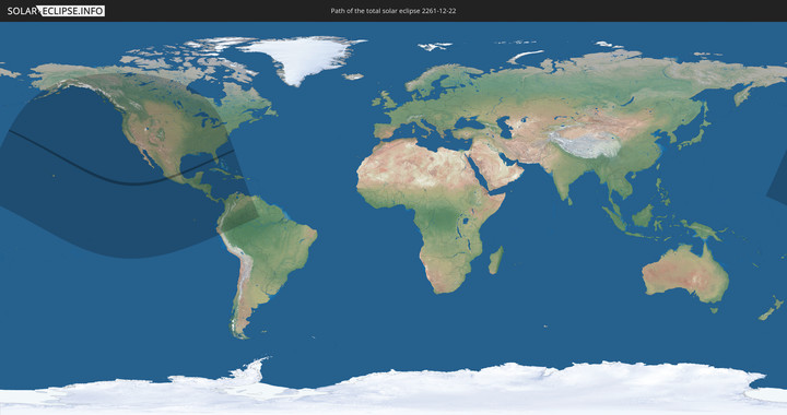
Totale Sonnenfinsternis vom 22.12.2261
| Wochentag: | Sonntag |
| Maximale Dauer der Verfinsterung: | 03m17s |
| Maximale Breite des Finsternispfades: | 147 km |
| Saroszyklus: | 136 |
| Bedeckungsgrad: | 100% |
| Magnitude: | 1.0337 |
| Gamma: | 0.636 |
Wo kann man die Sonnenfinsternis vom 22.12.2261 sehen?
Die Sonnenfinsternis am 22.12.2261 kann man in 28 Ländern als partielle Sonnenfinsternis beobachten.
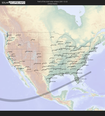
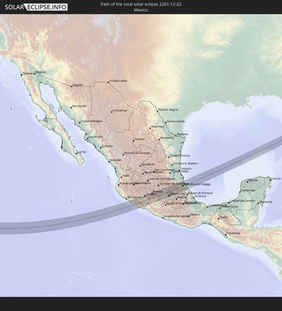
Der Finsternispfad verläuft durch 2 Länder. Nur in diesen Ländern ist sie als totale Sonnenfinsternis zu sehen.
In den folgenden Ländern ist die Sonnenfinsternis total zu sehen
In den folgenden Ländern ist die Sonnenfinsternis partiell zu sehen
 Vereinigte Staaten
 United States Minor Outlying Islands
 Kiribati
 Französisch-Polynesien
 Kanada
 Mexiko
 Grönland
 Guatemala
 Ecuador
 El Salvador
 Honduras
 Belize
 Nicaragua
 Costa Rica
 Kuba
Kuba
 Panama
 Kolumbien
 Kaimaninseln
 Peru
Peru
 Bahamas
 Jamaika
 Haiti
Haiti
 Brasilien
 Venezuela
 Turks- und Caicosinseln
 Dominikanische Republik
 Aruba
Aruba
 Marshallinseln
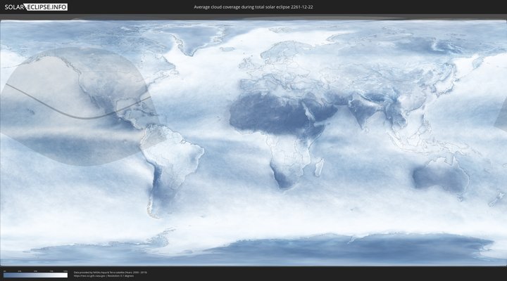
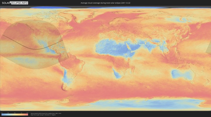
Wie wird das Wetter während der totalen Sonnenfinsternis am 22.12.2261?
Wo ist der beste Ort, um die totale Sonnenfinsternis vom 22.12.2261 zu beobachten?
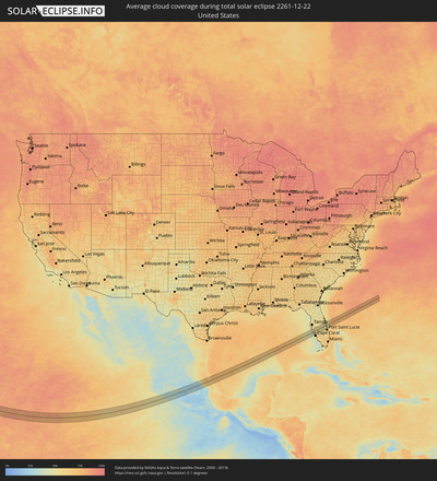
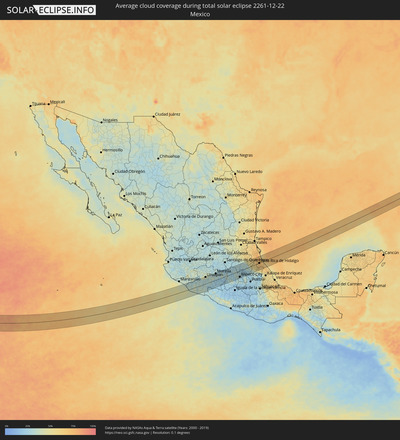
Die folgenden Karten zeigen die durchschnittliche Bewölkung für den Tag, an dem die totale Sonnenfinsternis
stattfindet. Mit Hilfe der Karten lässt sich der Ort entlang des Finsternispfades eingrenzen,
der die besten Aussichen auf einen klaren wolkenfreien Himmel bietet.
Trotzdem muss man immer lokale Gegenenheiten beachten und sollte sich genau über das Wetter an seinem
gewählten Beobachtungsort informieren.
Die Daten stammen von den beiden NASA-Satelliten
AQUA und TERRA
und wurden über einen Zeitraum von 19 Jahren (2000 - 2019) gemittelt.
Detaillierte Länderkarten
Orte im Finsternispfad
Die nachfolgene Tabelle zeigt Städte und Orte mit mehr als 5.000 Einwohnern, die sich im Finsternispfad befinden. Städte mit mehr als 100.000 Einwohnern sind dick gekennzeichnet. Mit einem Klick auf den Ort öffnet sich eine Detailkarte die die Lage des jeweiligen Ortes zusammen mit dem Verlauf der zentralen Finsternis präsentiert.
| Ort | Typ | Dauer der Verfinsterung | Ortszeit bei maximaler Verfinsterung | Entfernung zur Zentrallinie | Ø Bewölkung |
 Coahuayana Viejo, Michoacán
|
total | - | 15:22:59 UTC-06:00 | 45 km | 31% |
 Coalcomán de Vázquez Pallares, Michoacán
|
total | - | 15:24:00 UTC-06:00 | 30 km | 31% |
 Aguililla, Michoacán
|
total | - | 15:24:47 UTC-06:00 | 13 km | 33% |
 Felipe Carrillo Puerto, Michoacán
|
total | - | 15:24:43 UTC-06:00 | 55 km | 31% |
 Tancítaro, Michoacán
|
total | - | 15:25:19 UTC-06:00 | 61 km | 30% |
 Apatzingán, Michoacán
|
total | - | 15:25:28 UTC-06:00 | 35 km | 31% |
 Arteaga, Michoacán
|
total | - | 15:25:57 UTC-06:00 | 44 km | 35% |
 La Mira Tumbiscatio, Michoacán
|
total | - | 15:25:49 UTC-06:00 | 10 km | 31% |
 Nueva Italia de Ruiz, Michoacán
|
total | - | 15:26:01 UTC-06:00 | 19 km | 32% |
 Uruapan, Michoacán
|
total | - | 15:25:53 UTC-06:00 | 58 km | 35% |
 Lombardía, Michoacán
|
total | - | 15:26:02 UTC-06:00 | 31 km | 29% |
 Taretán, Michoacán
|
total | - | 15:26:12 UTC-06:00 | 45 km | 29% |
 Tingambato, Michoacán
|
total | - | 15:26:14 UTC-06:00 | 60 km | 37% |
 La Huacana, Michoacán
|
total | - | 15:26:36 UTC-06:00 | 2 km | 31% |
 Ario de Rosales, Michoacán
|
total | - | 15:26:40 UTC-06:00 | 24 km | 35% |
 Pátzcuaro, Michoacán
|
total | - | 15:26:42 UTC-06:00 | 53 km | 34% |
 Puruarán, Michoacán
|
total | - | 15:27:05 UTC-06:00 | 6 km | 27% |
 Pedernales, Michoacán
|
total | - | 15:27:10 UTC-06:00 | 9 km | 27% |
 Tacámbaro de Codallos, Michoacán
|
total | - | 15:27:08 UTC-06:00 | 18 km | 28% |
 Morelia, Michoacán
|
total | - | 15:27:25 UTC-06:00 | 57 km | 29% |
 Indaparapeo, Michoacán
|
total | - | 15:27:47 UTC-06:00 | 58 km | 25% |
 Zinapécuaro, Michoacán
|
total | - | 15:28:00 UTC-06:00 | 60 km | 23% |
 Ciudad Hidalgo, Michoacán
|
total | - | 15:28:36 UTC-06:00 | 33 km | 31% |
 Tuxpan, Michoacán
|
total | - | 15:28:50 UTC-06:00 | 16 km | 27% |
 Maravatío de Ocampo, Michoacán
|
total | - | 15:28:42 UTC-06:00 | 49 km | 24% |
 Luvianos, México
|
total | - | 15:29:17 UTC-06:00 | 54 km | 25% |
 Heróica Zitácuaro, Michoacán
|
total | - | 15:29:06 UTC-06:00 | 2 km | 27% |
 Colorines, México
|
total | - | 15:29:29 UTC-06:00 | 34 km | 29% |
 Valle de Bravo, México
|
total | - | 15:29:38 UTC-06:00 | 35 km | 30% |
 El Oro de Hidalgo, México
|
total | - | 15:29:19 UTC-06:00 | 28 km | 26% |
 Temascalcingo de José María Velazco, México
|
total | - | 15:29:29 UTC-06:00 | 35 km | 25% |
 Jesús del Monte, México
|
total | - | 15:29:56 UTC-06:00 | 48 km | 29% |
 Atlacomulco de Fabela, México
|
total | - | 15:29:47 UTC-06:00 | 18 km | 25% |
 La Concepción de los Baños, México
|
total | - | 15:29:52 UTC-06:00 | 5 km | 24% |
 Barrio de México, México
|
total | - | 15:30:08 UTC-06:00 | 37 km | 30% |
 San Pedro Los Baños, México
|
total | - | 15:29:58 UTC-06:00 | 2 km | 24% |
 Emiliano Zapata (Santo Domingo), México
|
total | - | 15:30:03 UTC-06:00 | 8 km | 24% |
 Ixtlahuaca de Rayón, México
|
total | - | 15:30:06 UTC-06:00 | 10 km | 24% |
 La Cabecera, México
|
total | - | 15:30:15 UTC-06:00 | 33 km | 26% |
 Fraccionamiento Colinas del Sol, México
|
total | - | 15:30:15 UTC-06:00 | 31 km | 26% |
 Santa Cruz Cuauhtenco, México
|
total | - | 15:30:20 UTC-06:00 | 45 km | 32% |
 Toluca, México
|
total | - | 15:30:27 UTC-06:00 | 43 km | 27% |
 Zaragoza de Guadalupe, Morelos
|
total | - | 15:30:32 UTC-06:00 | 58 km | 29% |
 San Bartolomé Tlaltelulco, Morelos
|
total | - | 15:30:32 UTC-06:00 | 51 km | 25% |
 Santa María Nativitas, México
|
total | - | 15:30:32 UTC-06:00 | 52 km | 25% |
 San Nicolás Tolentino, México
|
total | - | 15:30:34 UTC-06:00 | 39 km | 24% |
 Ex-Rancho San Dimas, México
|
total | - | 15:30:40 UTC-06:00 | 59 km | 25% |
 Atizapán, México
|
total | - | 15:30:39 UTC-06:00 | 51 km | 24% |
 La Constitución Toltepec, México
|
total | - | 15:30:36 UTC-06:00 | 41 km | 23% |
 Jilotepec de Molina Enríquez, México
|
total | - | 15:30:19 UTC-06:00 | 21 km | 30% |
 Xonacatlán, México
|
total | - | 15:30:37 UTC-06:00 | 36 km | 26% |
 Ocoyoacac, México
|
total | - | 15:30:49 UTC-06:00 | 53 km | 23% |
 San Francisco Chimalpa, Morelos
|
total | - | 15:30:55 UTC-06:00 | 39 km | 31% |
 Tula de Allende, Hidalgo
|
total | - | 15:30:36 UTC-06:00 | 24 km | 28% |
 Tepeji de Ocampo, Hidalgo
|
total | - | 15:30:41 UTC-06:00 | 9 km | 30% |
 Cuajimalpa, Mexico City
|
total | - | 15:31:03 UTC-06:00 | 50 km | 31% |
 Tezontepec de Aldama, Hidalgo
|
total | - | 15:30:39 UTC-06:00 | 36 km | 30% |
 Ciudad López Mateos, México
|
total | - | 15:31:00 UTC-06:00 | 28 km | 31% |
 Presas, Hidalgo
|
total | - | 15:30:42 UTC-06:00 | 32 km | 30% |
 San Mateo Xoloc, México
|
total | - | 15:30:57 UTC-06:00 | 15 km | 30% |
 Doxey, Hidalgo
|
total | - | 15:30:45 UTC-06:00 | 24 km | 27% |
 Santa Cruz del Monte, México
|
total | - | 15:30:57 UTC-06:00 | 10 km | 29% |
 Atitalaquia, Hidalgo
|
total | - | 15:30:48 UTC-06:00 | 20 km | 27% |
 Vista Hermosa, México
|
total | - | 15:31:06 UTC-06:00 | 36 km | 29% |
 Huehuetoca, México
|
total | - | 15:30:58 UTC-06:00 | 4 km | 29% |
 Teoloyucan, México
|
total | - | 15:31:03 UTC-06:00 | 14 km | 29% |
 Tetepango, Hidalgo
|
total | - | 15:30:54 UTC-06:00 | 22 km | 27% |
 Tequixquiac, México
|
total | - | 15:31:01 UTC-06:00 | 2 km | 25% |
 Mexico City, Mexico City
|
total | - | 15:31:19 UTC-06:00 | 49 km | 25% |
 Ajacuba, Hidalgo
|
total | - | 15:30:58 UTC-06:00 | 20 km | 26% |
 Tepatepec, Hidalgo
|
total | - | 15:30:56 UTC-06:00 | 34 km | 28% |
 Ecatepec, México
|
total | - | 15:31:19 UTC-06:00 | 32 km | 28% |
 San Francisco Zacacalco, Morelos
|
total | - | 15:31:18 UTC-06:00 | 3 km | 24% |
 Tizayuca, Hidalgo
|
total | - | 15:31:21 UTC-06:00 | 12 km | 25% |
 Santa María Chimalhuacán, México
|
total | - | 15:31:37 UTC-06:00 | 56 km | 24% |
 Actopan, Hidalgo
|
total | - | 15:31:11 UTC-06:00 | 31 km | 31% |
 San Agustín Tlaxiaca, Hidalgo
|
total | - | 15:31:22 UTC-06:00 | 13 km | 26% |
 Chiautla, México
|
total | - | 15:31:40 UTC-06:00 | 46 km | 26% |
 Zapotlán de Juárez, Hidalgo
|
total | - | 15:31:29 UTC-06:00 | 2 km | 23% |
 Teotihuacán de Arista, México
|
total | - | 15:31:38 UTC-06:00 | 32 km | 25% |
 Acayuca, Hidalgo
|
total | - | 15:31:29 UTC-06:00 | 2 km | 23% |
 Pachuca de Soto, Hidalgo
|
total | - | 15:31:37 UTC-06:00 | 7 km | 25% |
 Atotonilco el Grande, Hidalgo
|
total | - | 15:31:39 UTC-06:00 | 22 km | 33% |
 Ciudad Sahagun, Hidalgo
|
total | - | 15:32:05 UTC-06:00 | 34 km | 23% |
 Calpulalpan, Tlaxcala
|
total | - | 15:32:11 UTC-06:00 | 54 km | 28% |
 Tulancingo, Hidalgo
|
total | - | 15:32:17 UTC-06:00 | 11 km | 33% |
 Huauchinango, Puebla
|
total | - | 15:32:45 UTC-06:00 | 14 km | 48% |
 Tenango de las Flores, Puebla
|
total | - | 15:32:50 UTC-06:00 | 13 km | 51% |
 Zacatlán, Puebla
|
total | - | 15:33:02 UTC-06:00 | 42 km | 35% |
 Xicotepec de Juárez, Puebla
|
total | - | 15:32:51 UTC-06:00 | 7 km | 54% |
 La Ceiba, Veracruz
|
total | - | 15:32:40 UTC-06:00 | 40 km | 63% |
 Filomeno Mata, Puebla
|
total | - | 15:33:19 UTC-06:00 | 25 km | 58% |
 Álamo, Veracruz
|
total | - | 15:32:58 UTC-06:00 | 47 km | 70% |
 Venustiano Carranza, Puebla
|
total | - | 15:33:12 UTC-06:00 | 5 km | 64% |
 Tihuatlan, Veracruz
|
total | - | 15:33:19 UTC-06:00 | 22 km | 72% |
 Poza Rica de Hidalgo, Veracruz
|
total | - | 15:33:32 UTC-06:00 | 0 km | 70% |
 Tuxpan de Rodríguez Cano, Veracruz
|
total | - | 15:33:23 UTC-06:00 | 42 km | 69% |
 Papantla de Olarte, Veracruz
|
total | - | 15:33:48 UTC-06:00 | 14 km | 68% |
 Gutiérrez Zamora, Veracruz
|
total | - | 15:34:11 UTC-06:00 | 23 km | 66% |
 Vega de San Marcos, Veracruz
|
total | - | 15:34:33 UTC-06:00 | 56 km | 67% |
 Siesta Key, Florida
|
total | - | 16:46:39 UTC-05:00 | 34 km | 52% |
 Sarasota, Florida
|
total | - | 16:46:36 UTC-05:00 | 40 km | 52% |
 North Sarasota, Florida
|
total | - | 16:46:35 UTC-05:00 | 43 km | 57% |
 Gulf Gate Estates, Florida
|
total | - | 16:46:41 UTC-05:00 | 31 km | 52% |
 Southgate, Florida
|
total | - | 16:46:38 UTC-05:00 | 36 km | 52% |
 South Gate Ridge, Florida
|
total | - | 16:46:40 UTC-05:00 | 33 km | 52% |
 Osprey, Florida
|
total | - | 16:46:45 UTC-05:00 | 24 km | 47% |
 Bee Ridge, Florida
|
total | - | 16:46:41 UTC-05:00 | 32 km | 52% |
 Sarasota Springs, Florida
|
total | - | 16:46:40 UTC-05:00 | 35 km | 52% |
 Laurel, Florida
|
total | - | 16:46:48 UTC-05:00 | 18 km | 44% |
 Fruitville, Florida
|
total | - | 16:46:40 UTC-05:00 | 36 km | 52% |
 Venice, Florida
|
total | - | 16:46:51 UTC-05:00 | 13 km | 44% |
 South Venice, Florida
|
total | - | 16:46:55 UTC-05:00 | 7 km | 49% |
 Venice Gardens, Florida
|
total | - | 16:46:54 UTC-05:00 | 8 km | 49% |
 Englewood, Florida
|
total | - | 16:47:02 UTC-05:00 | 5 km | 45% |
 Rotonda, Florida
|
total | - | 16:47:09 UTC-05:00 | 16 km | 47% |
 Warm Mineral Springs, Florida
|
total | - | 16:47:02 UTC-05:00 | 0 km | 51% |
 North Port, Florida
|
total | - | 16:47:04 UTC-05:00 | 2 km | 48% |
 Port Charlotte, Florida
|
total | - | 16:47:14 UTC-05:00 | 16 km | 54% |
 Punta Gorda Isles, Florida
|
total | - | 16:47:17 UTC-05:00 | 22 km | 49% |
 Punta Gorda, Florida
|
total | - | 16:47:18 UTC-05:00 | 22 km | 53% |
 Arcadia, Florida
|
total | - | 16:47:13 UTC-05:00 | 2 km | 58% |
 Southeast Arcadia, Florida
|
total | - | 16:47:15 UTC-05:00 | 6 km | 58% |
 Wauchula, Florida
|
total | - | 16:46:59 UTC-05:00 | 28 km | 57% |
 Avon Park, Florida
|
total | - | 16:47:11 UTC-05:00 | 20 km | 58% |
 Sebring, Florida
|
total | - | 16:47:19 UTC-05:00 | 7 km | 54% |
 West Melbourne, Florida
|
total | - | 16:47:25 UTC-05:00 | 28 km | 61% |
 South Patrick Shores, Florida
|
total | - | 16:47:20 UTC-05:00 | 39 km | 55% |
 Melbourne, Florida
|
total | - | 16:47:26 UTC-05:00 | 28 km | 60% |
 Fellsmere, Florida
|
total | - | 16:47:42 UTC-05:00 | 4 km | 58% |
 Satellite Beach, Florida
|
total | - | 16:47:22 UTC-05:00 | 36 km | 55% |
 Palm Bay, Florida
|
total | - | 16:47:29 UTC-05:00 | 22 km | 58% |
 Indian Harbour Beach, Florida
|
total | - | 16:47:24 UTC-05:00 | 33 km | 60% |
 Micco, Florida
|
total | - | 16:47:41 UTC-05:00 | 3 km | 57% |
 West Vero Corridor, Florida
|
total | - | 16:47:53 UTC-05:00 | 22 km | 62% |
 Sebastian, Florida
|
total | - | 16:47:45 UTC-05:00 | 5 km | 56% |
 Vero Beach South, Florida
|
total | - | 16:47:57 UTC-05:00 | 28 km | 60% |
 Gifford, Florida
|
total | - | 16:47:55 UTC-05:00 | 22 km | 57% |
 Lakewood Park, Florida
|
total | - | 16:48:01 UTC-05:00 | 35 km | 63% |
 Vero Beach, Florida
|
total | - | 16:47:57 UTC-05:00 | 26 km | 60% |
 Florida Ridge, Florida
|
total | - | 16:48:00 UTC-05:00 | 32 km | 60% |
 Lakewood Park, Florida
|
total | - | 16:48:05 UTC-05:00 | 43 km | 63% |
 Fort Pierce North, Florida
|
total | - | 16:48:06 UTC-05:00 | 44 km | 63% |
