Totale Sonnenfinsternis vom 17.05.2292
| Wochentag: | Dienstag |
| Maximale Dauer der Verfinsterung: | 04m56s |
| Maximale Breite des Finsternispfades: | 220 km |
| Saroszyklus: | 152 |
| Bedeckungsgrad: | 100% |
| Magnitude: | 1.0521 |
| Gamma: | -0.6224 |
Wo kann man die Sonnenfinsternis vom 17.05.2292 sehen?
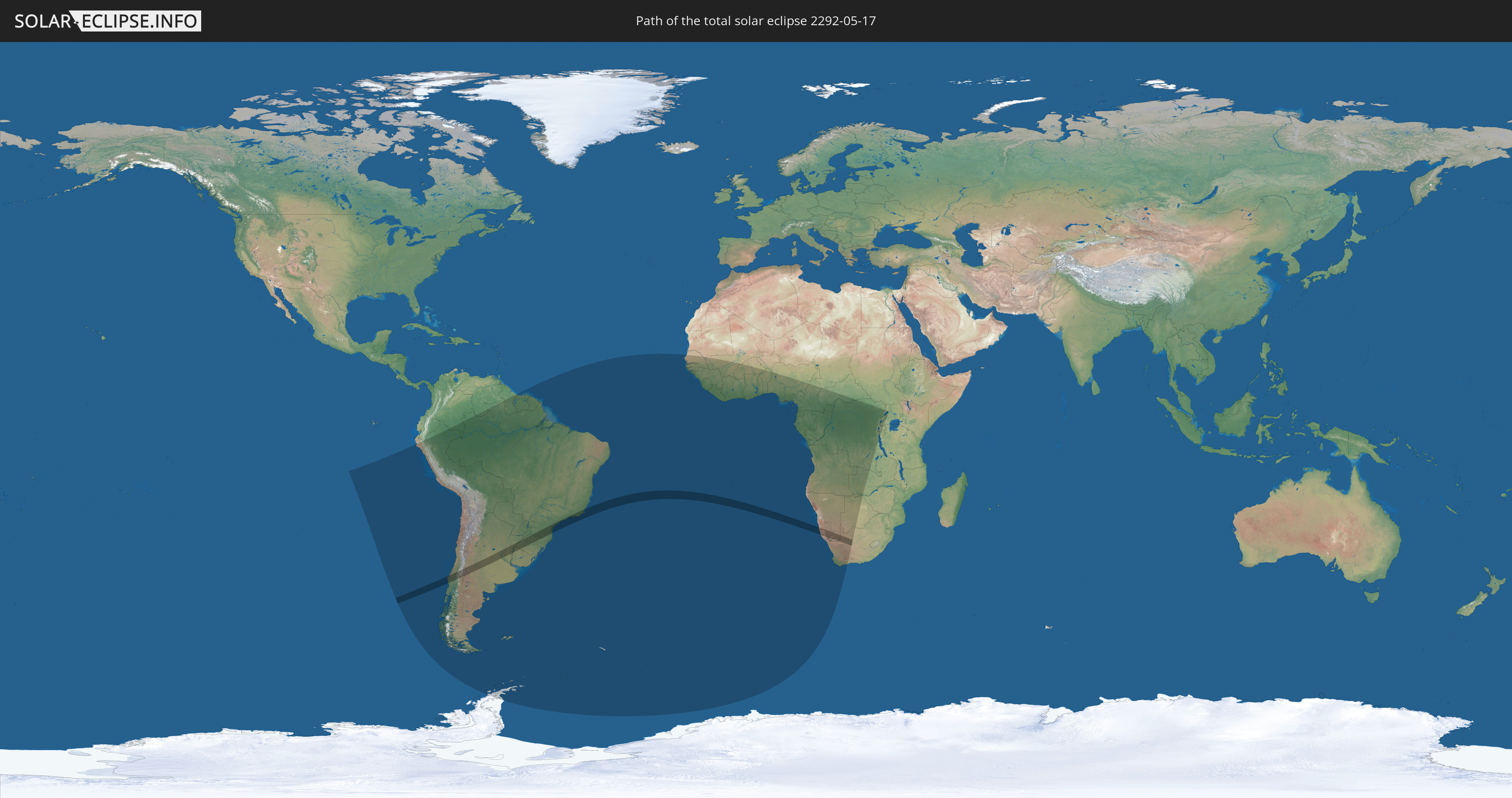
Die Sonnenfinsternis am 17.05.2292 kann man in 50 Ländern als partielle Sonnenfinsternis beobachten.
Der Finsternispfad verläuft durch 6 Länder. Nur in diesen Ländern ist sie als totale Sonnenfinsternis zu sehen.
In den folgenden Ländern ist die Sonnenfinsternis total zu sehen
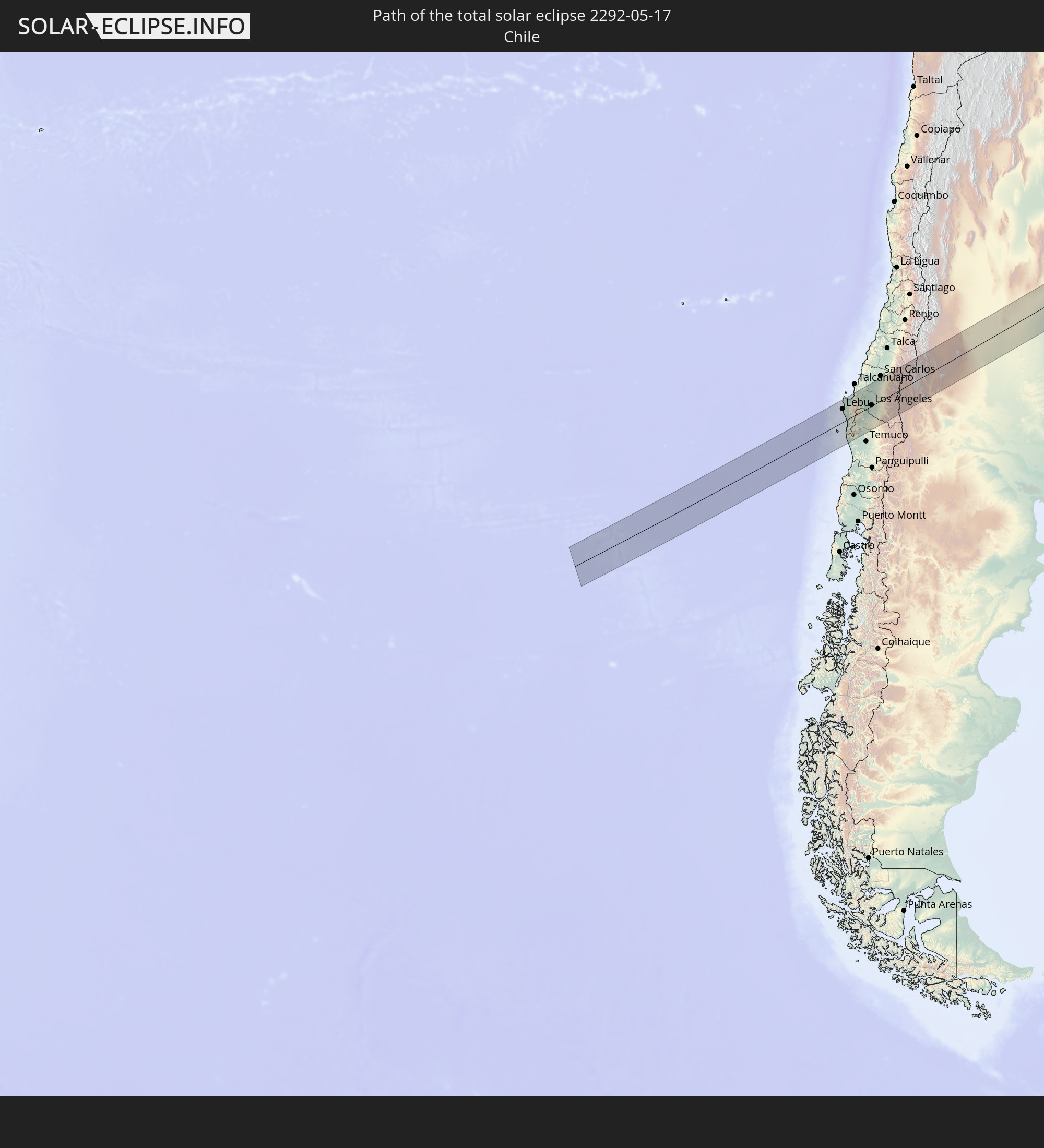 Chile
Chile
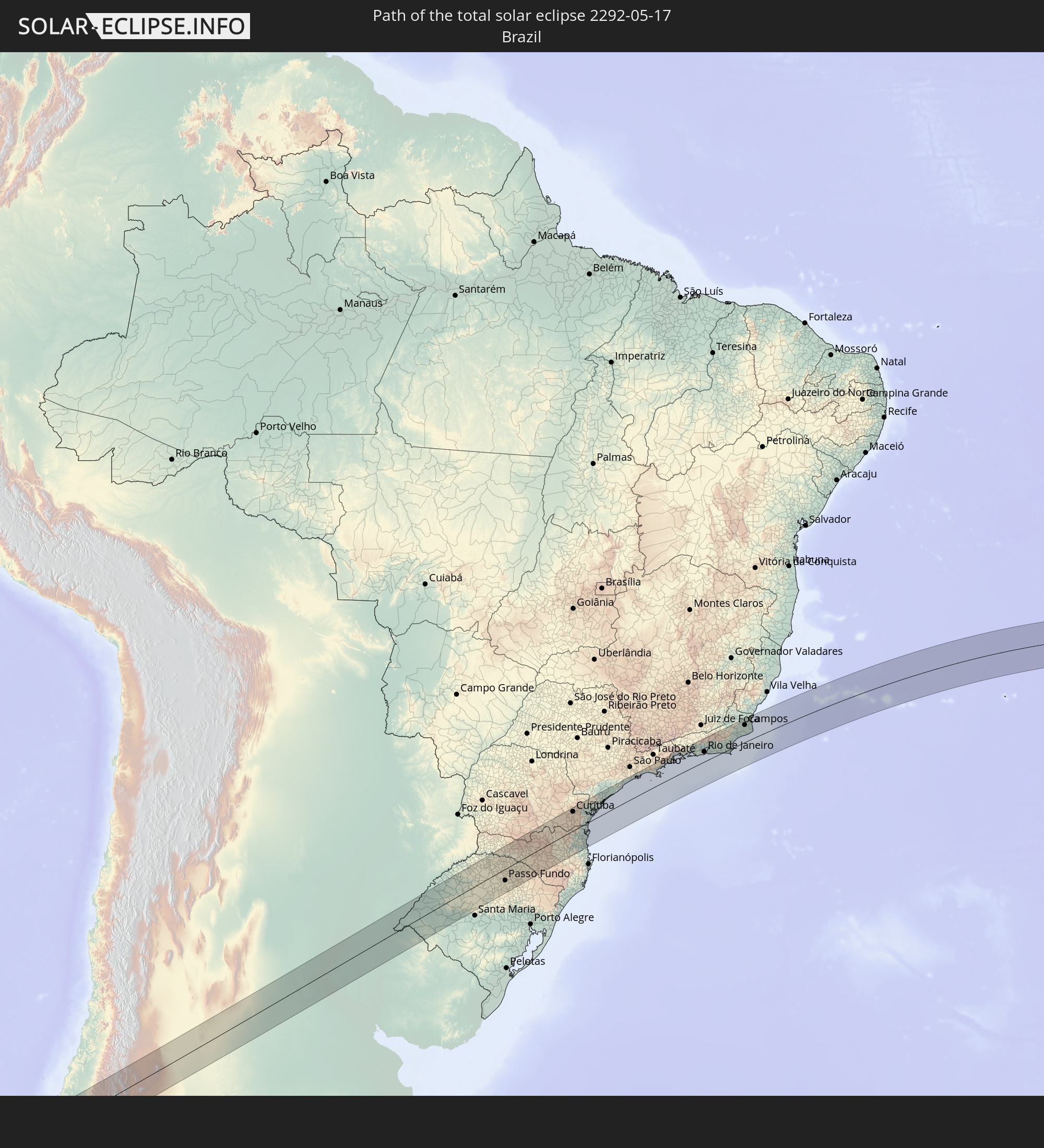 Brasilien
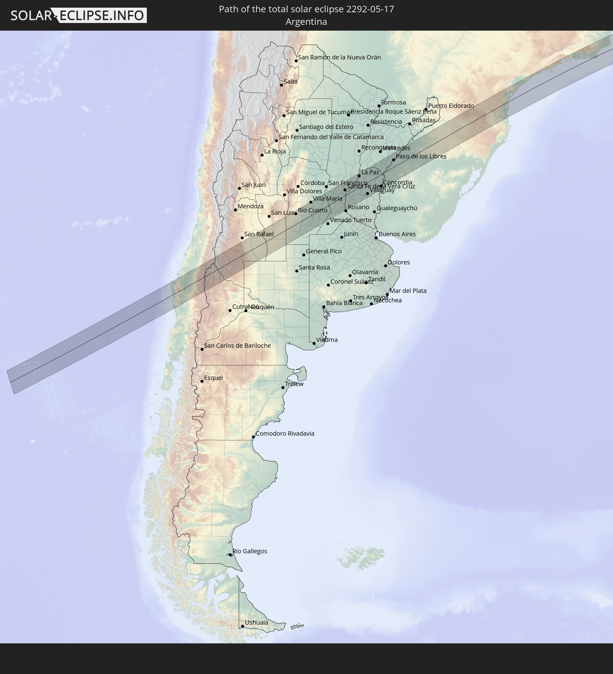 Argentinien
 Uruguay
 Namibia
 Südafrika
In den folgenden Ländern ist die Sonnenfinsternis partiell zu sehen
 Antarktika
 Chile
Chile
 Ecuador
 Kolumbien
 Peru
Peru
 Brasilien
 Argentinien
 Venezuela
 Bolivien
 Paraguay
 Falklandinseln
 Guyana
 Uruguay
 Suriname
 Französisch-Guayana
 Südgeorgien und die Südlichen Sandwichinseln
 Kap Verde
 Senegal
 Mauretanien
 Gambia
 Guinea-Bissau
 Guinea
 St. Helena
 Sierra Leone
 Mali
Mali
 Liberia
 Elfenbeinküste
 Burkina Faso
 Ghana
Ghana
 Togo
Togo
 Benin
Benin
 Nigeria
 Bouvetinsel
 Äquatorialguinea
 São Tomé und Príncipe
 Kamerun
 Gabun
Gabun
 Republik Kongo
 Angola
 Namibia
 Demokratische Republik Kongo
 Tschad
 Zentralafrikanische Republik
 Südafrika
 Botswana
 Sambia
 Simbabwe
 Ruanda
 Burundi
 Uganda
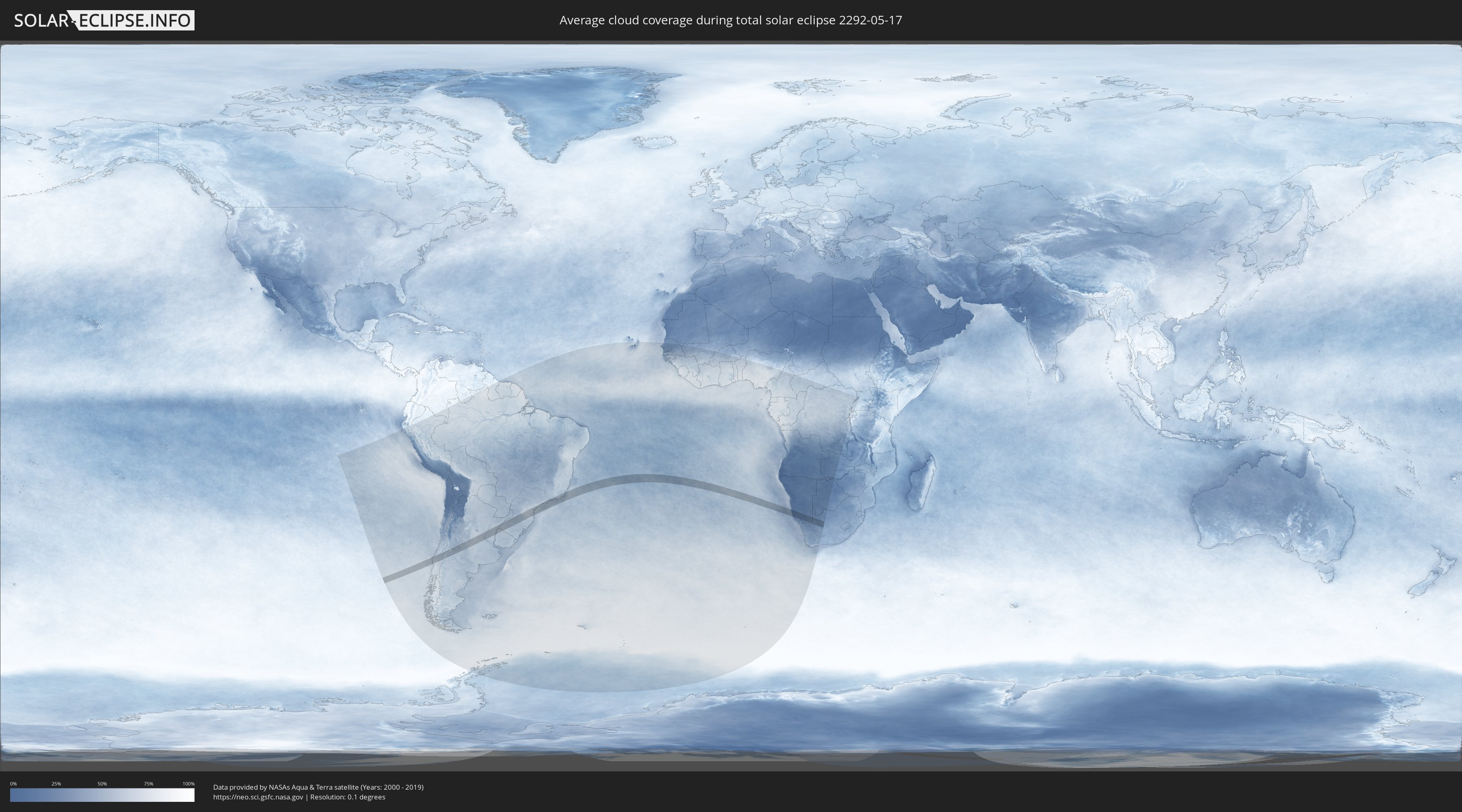
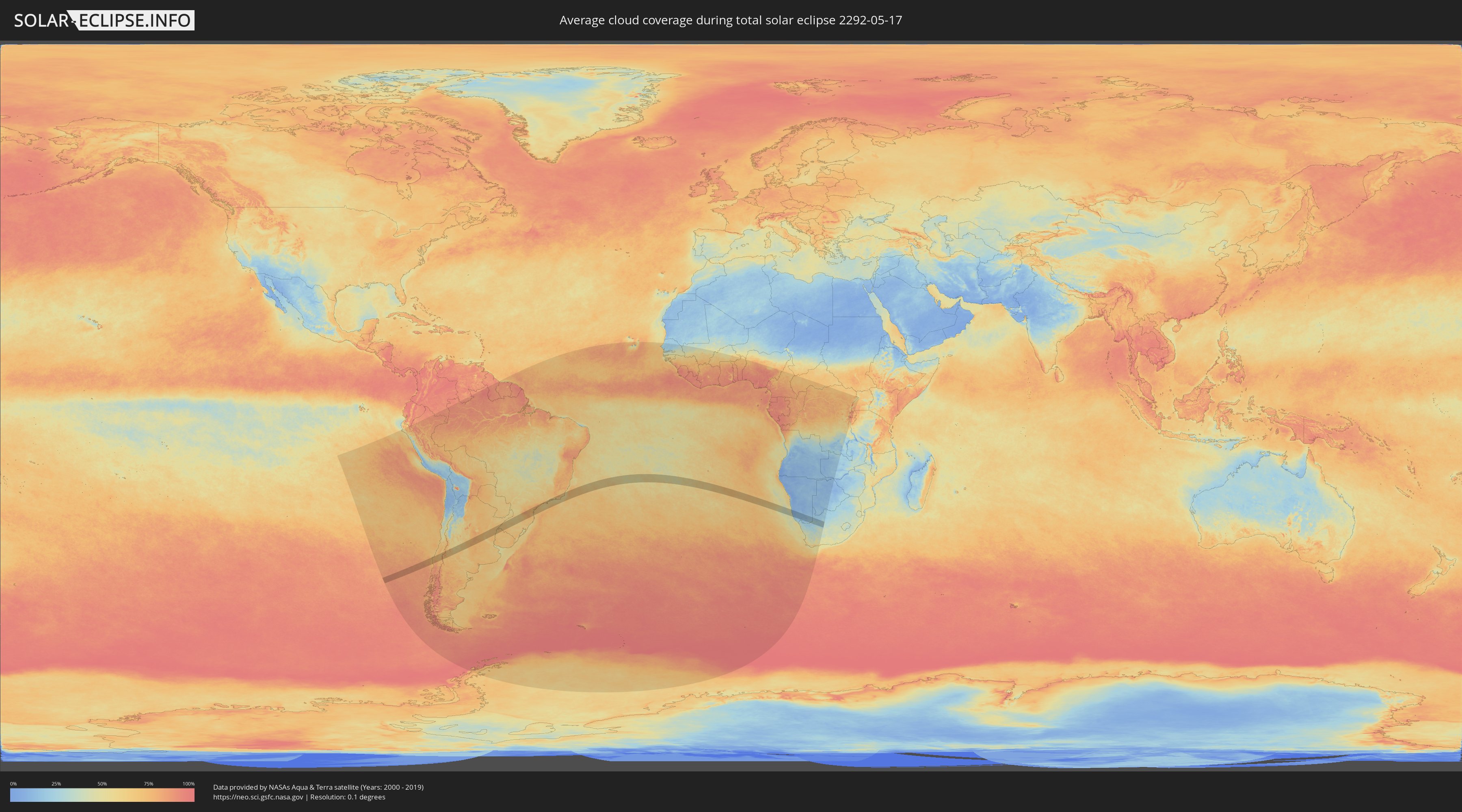
Wie wird das Wetter während der totalen Sonnenfinsternis am 17.05.2292?
Wo ist der beste Ort, um die totale Sonnenfinsternis vom 17.05.2292 zu beobachten?
Die folgenden Karten zeigen die durchschnittliche Bewölkung für den Tag, an dem die totale Sonnenfinsternis
stattfindet. Mit Hilfe der Karten lässt sich der Ort entlang des Finsternispfades eingrenzen,
der die besten Aussichen auf einen klaren wolkenfreien Himmel bietet.
Trotzdem muss man immer lokale Gegenenheiten beachten und sollte sich genau über das Wetter an seinem
gewählten Beobachtungsort informieren.
Die Daten stammen von den beiden NASA-Satelliten
AQUA und TERRA
und wurden über einen Zeitraum von 19 Jahren (2000 - 2019) gemittelt.
Detaillierte Länderkarten
 Chile
Chile
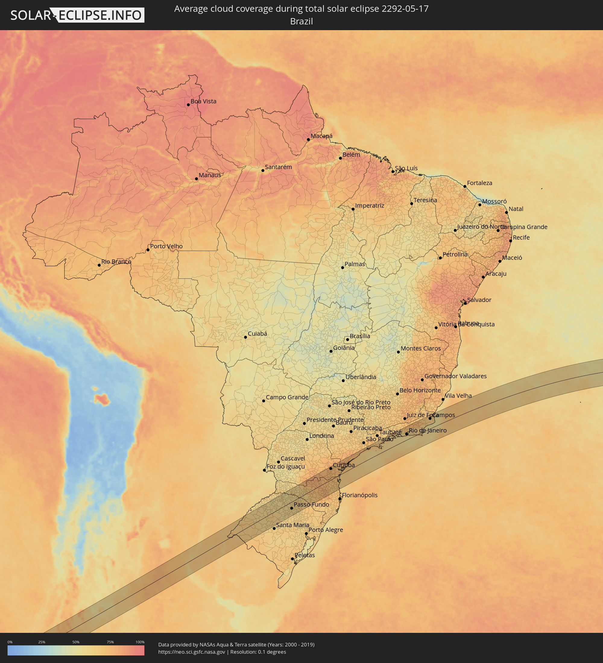 Brasilien
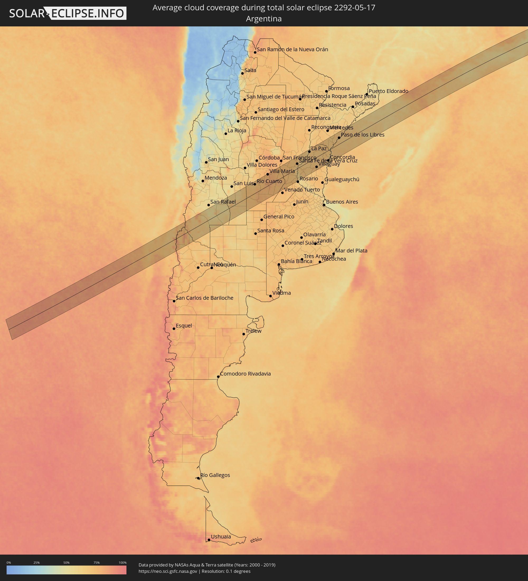 Argentinien
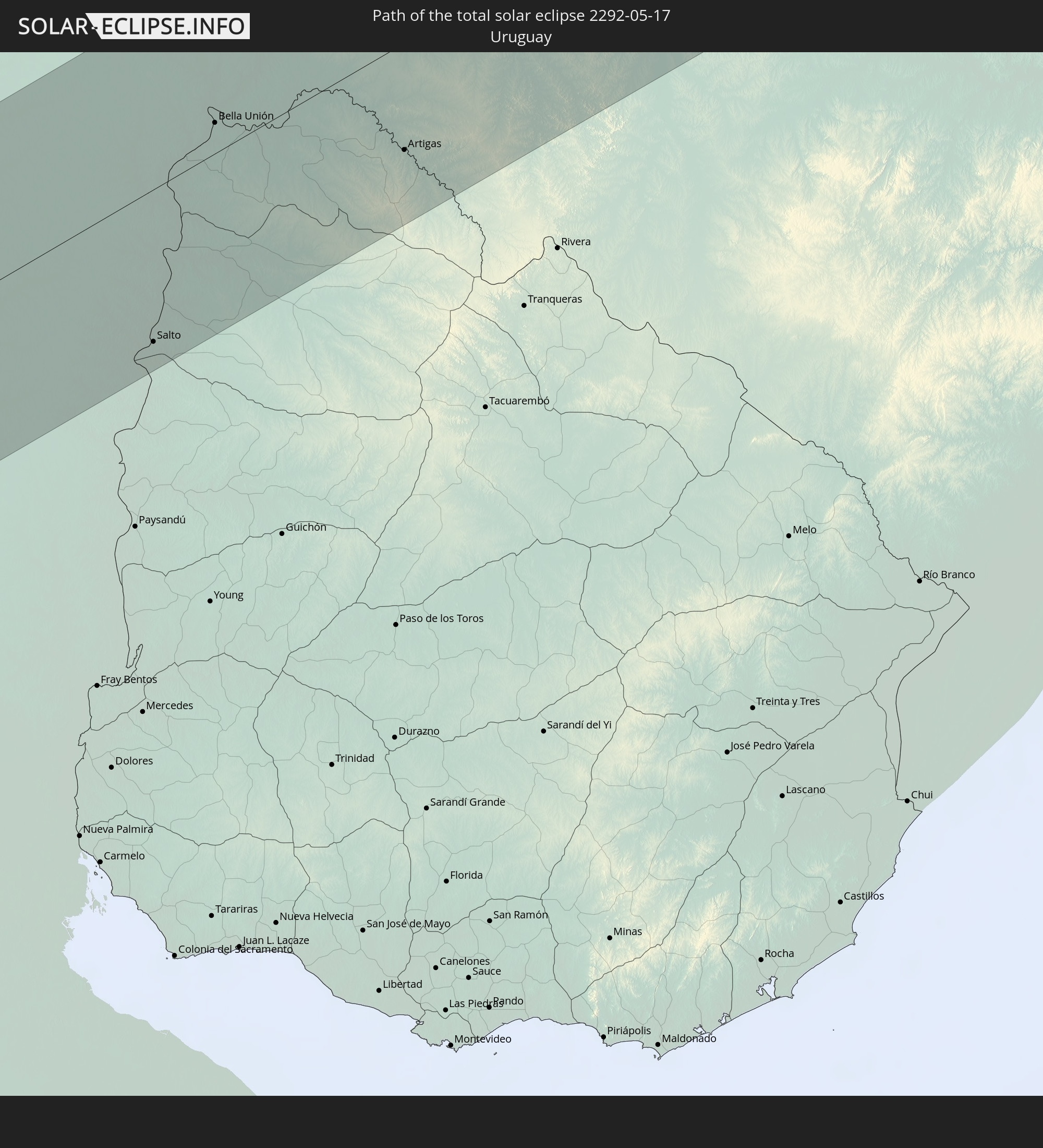
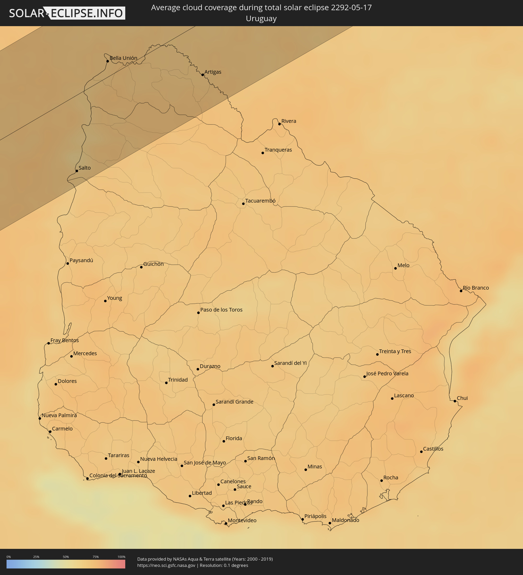 Uruguay
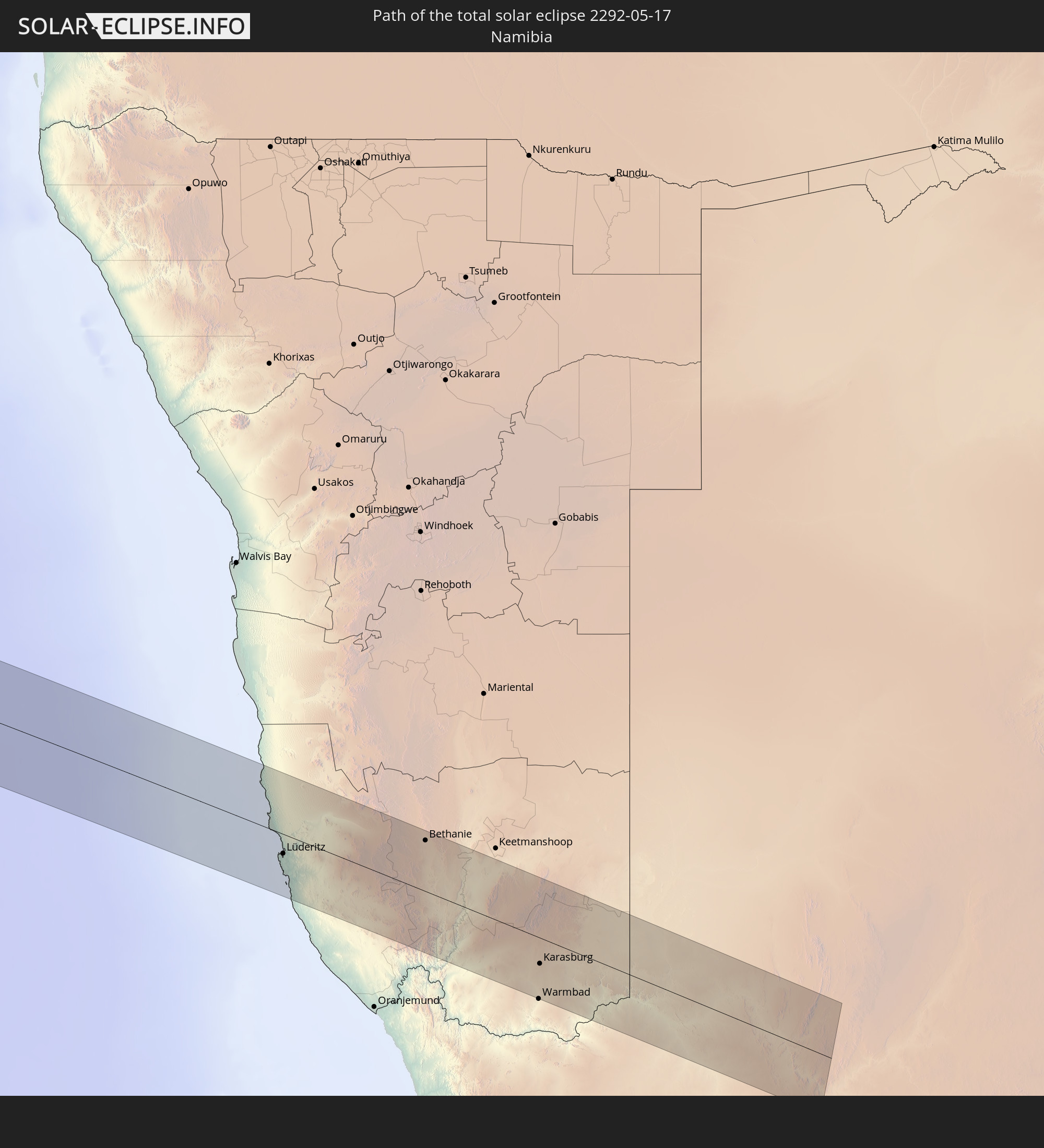
 Namibia
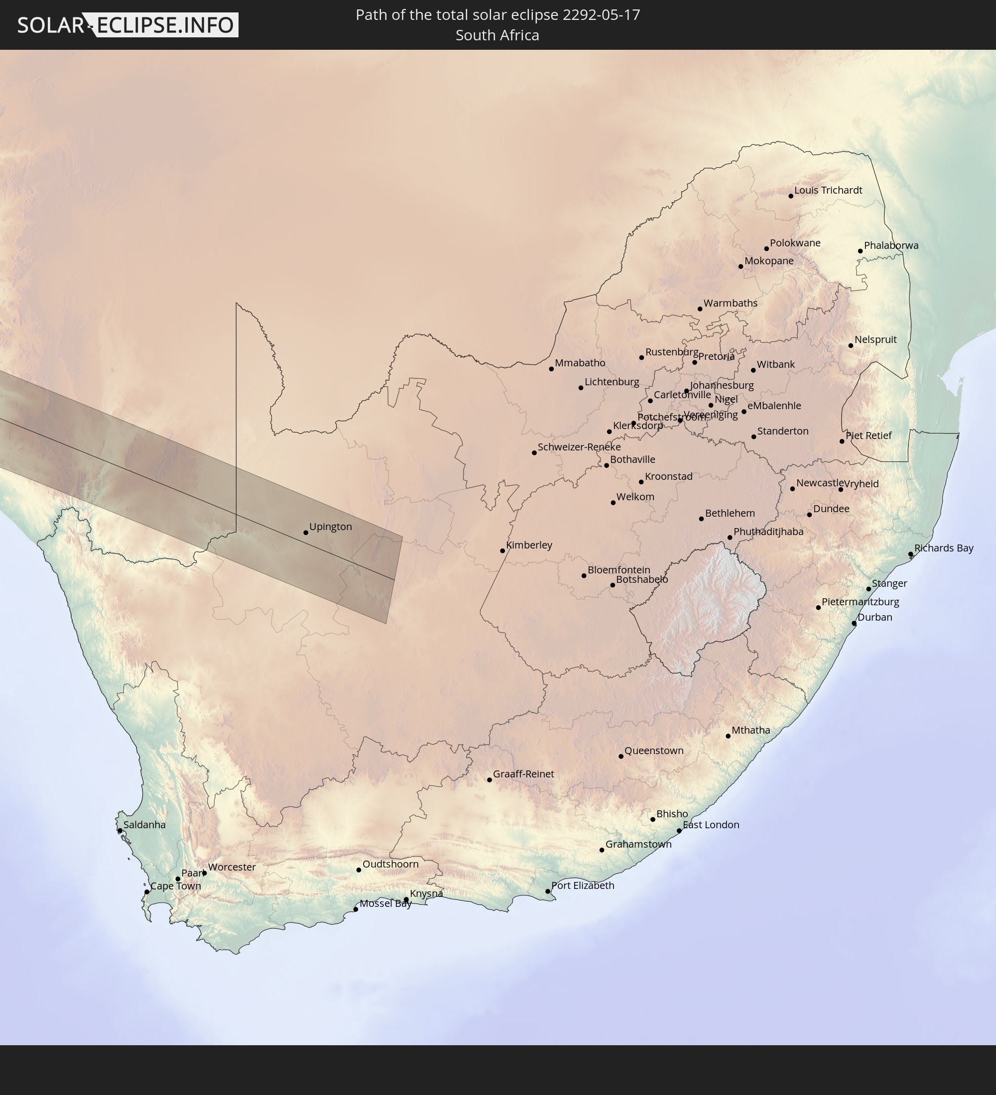
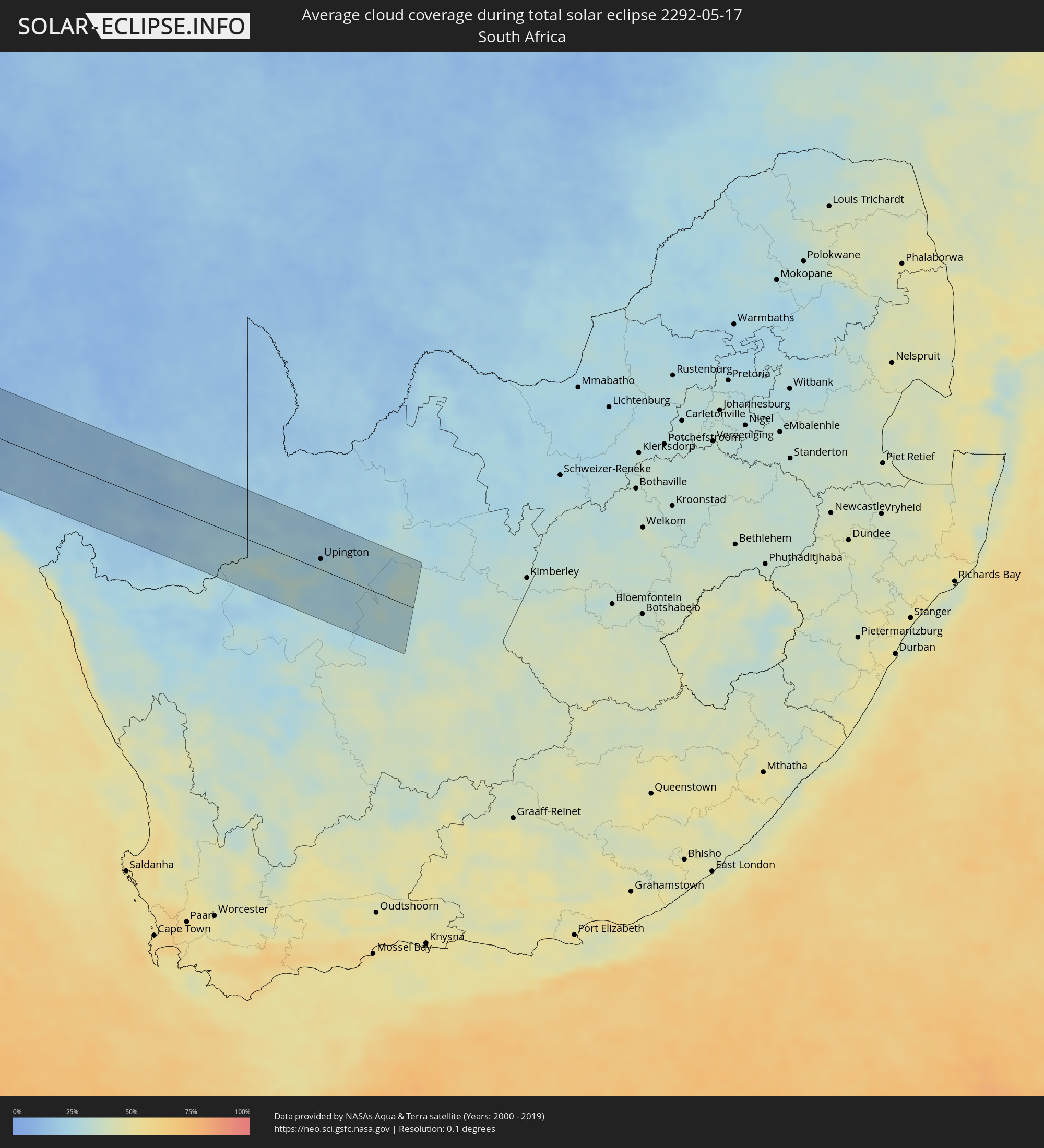 Südafrika
Orte im Finsternispfad
Die nachfolgene Tabelle zeigt Städte und Orte mit mehr als 5.000 Einwohnern, die sich im Finsternispfad befinden. Städte mit mehr als 100.000 Einwohnern sind dick gekennzeichnet. Mit einem Klick auf den Ort öffnet sich eine Detailkarte die die Lage des jeweiligen Ortes zusammen mit dem Verlauf der zentralen Finsternis präsentiert.
| Ort | Typ | Dauer der Verfinsterung | Ortszeit bei maximaler Verfinsterung | Entfernung zur Zentrallinie | Ø Bewölkung |
|
Lebu, Biobío
|
total | - | 09:58:17 UTC-03:00 | 45 km | 70% |
|
Cañete, Biobío
|
total | - | 09:58:36 UTC-03:00 | 15 km | 72% |
|
Curanilahue, Biobío
|
total | - | 09:58:25 UTC-03:00 | 44 km | 70% |
|
Arauco, Biobío
|
total | - | 09:58:17 UTC-03:00 | 65 km | 70% |
|
Lota, Biobío
|
total | - | 09:58:18 UTC-03:00 | 74 km | 68% |
|
Coronel, Biobío
|
total | - | 09:58:16 UTC-03:00 | 78 km | 71% |
|
Angol, Araucanía
|
total | - | 09:59:07 UTC-03:00 | 14 km | 74% |
|
La Laja, Biobío
|
total | - | 09:58:46 UTC-03:00 | 36 km | 71% |
|
Nacimiento, Biobío
|
total | - | 09:58:57 UTC-03:00 | 13 km | 73% |
|
Traiguén, Araucanía
|
total | - | 09:59:28 UTC-03:00 | 60 km | 79% |
|
Yumbel, Biobío
|
total | - | 09:58:46 UTC-03:00 | 47 km | 70% |
|
Collipulli, Araucanía
|
total | - | 09:59:27 UTC-03:00 | 41 km | 75% |
|
Cabrero, Biobío
|
total | - | 09:58:50 UTC-03:00 | 47 km | 74% |
|
Los Ángeles, Biobío
|
total | - | 09:59:10 UTC-03:00 | 2 km | 72% |
|
Victoria, Araucanía
|
total | - | 09:59:43 UTC-03:00 | 73 km | 77% |
|
Bulnes, Biobío
|
total | - | 09:58:44 UTC-03:00 | 70 km | 75% |
|
Mulchén, Biobío
|
total | - | 09:59:26 UTC-03:00 | 27 km | 70% |
|
Chillán, Biobío
|
total | - | 09:58:48 UTC-03:00 | 75 km | 73% |
|
Coihueco, Biobío
|
total | - | 09:59:02 UTC-03:00 | 61 km | 68% |
|
Chos Malal, Neuquén Province
|
total | - | 10:00:50 UTC-03:00 | 80 km | 71% |
|
Villa Mercedes, San Luis Province
|
total | - | 10:03:24 UTC-03:00 | 60 km | 67% |
|
Río Cuarto, Cordoba Province
|
total | - | 10:04:23 UTC-03:00 | 61 km | 71% |
|
Laboulaye, Cordoba Province
|
total | - | 10:05:58 UTC-03:00 | 80 km | 76% |
|
Villa María, Cordoba Province
|
total | - | 10:05:23 UTC-03:00 | 78 km | 78% |
|
Bell Ville, Cordoba Province
|
total | - | 10:06:09 UTC-03:00 | 31 km | 78% |
|
Marcos Juárez, Cordoba Province
|
total | - | 10:06:54 UTC-03:00 | 3 km | 75% |
|
San Jorge, Santa Fe Province
|
total | - | 10:06:54 UTC-03:00 | 62 km | 73% |
|
Las Rosas, Santa Fe Province
|
total | - | 10:07:29 UTC-03:00 | 7 km | 71% |
|
Cañada de Gómez, Santa Fe Province
|
total | - | 10:07:51 UTC-03:00 | 48 km | 73% |
|
Gálvez, Santa Fe Province
|
total | - | 10:07:46 UTC-03:00 | 19 km | 71% |
|
Casilda, Santa Fe Province
|
total | - | 10:08:14 UTC-03:00 | 81 km | 72% |
|
Carcarañá, Santa Fe Province
|
total | - | 10:08:10 UTC-03:00 | 64 km | 73% |
|
Esperanza, Santa Fe Province
|
total | - | 10:07:57 UTC-03:00 | 61 km | 71% |
|
Coronda, Santa Fe Province
|
total | - | 10:08:09 UTC-03:00 | 10 km | 63% |
|
Roldán, Santa Fe Province
|
total | - | 10:08:31 UTC-03:00 | 79 km | 71% |
|
Recreo, Santa Fe Province
|
total | - | 10:08:13 UTC-03:00 | 48 km | 66% |
|
Granadero Baigorria, Santa Fe Province
|
total | - | 10:08:45 UTC-03:00 | 84 km | 67% |
|
Santa Fe de la Vera Cruz, Santa Fe Province
|
total | - | 10:08:19 UTC-03:00 | 32 km | 66% |
|
Laguna Paiva, Santa Fe Province
|
total | - | 10:08:16 UTC-03:00 | 62 km | 70% |
|
Diamante, Entre Ríos Province
|
total | - | 10:08:33 UTC-03:00 | 12 km | 65% |
|
Paraná, Entre Ríos Province
|
total | - | 10:08:35 UTC-03:00 | 14 km | 66% |
|
Crespo, Entre Ríos Province
|
total | - | 10:08:59 UTC-03:00 | 24 km | 71% |
|
Santa Elena, Entre Ríos Province
|
total | - | 10:09:20 UTC-03:00 | 55 km | 67% |
|
La Paz, Entre Ríos Province
|
total | - | 10:09:28 UTC-03:00 | 67 km | 67% |
|
Villaguay, Entre Ríos Province
|
total | - | 10:10:41 UTC-03:00 | 70 km | 70% |
|
Federal, Entre Ríos Province
|
total | - | 10:10:45 UTC-03:00 | 6 km | 67% |
|
San Salvador, Entre Ríos Province
|
total | - | 10:11:21 UTC-03:00 | 72 km | 70% |
|
Curuzú Cuatiá, Corrientes Province
|
total | - | 10:11:31 UTC-03:00 | 82 km | 68% |
|
Concordia, Entre Ríos Province
|
total | - | 10:11:59 UTC-03:00 | 73 km | 64% |
|
Chajarí, Entre Ríos Province
|
total | - | 10:11:52 UTC-03:00 | 14 km | 67% |
|
Salto, Salto
|
total | - | 10:12:04 UTC-03:00 | 75 km | 64% |
|
Federación, Entre Ríos Province
|
total | - | 10:12:03 UTC-03:00 | 42 km | 63% |
|
Monte Caseros, Corrientes Province
|
total | - | 10:12:15 UTC-03:00 | 18 km | 67% |
|
Bella Unión, Artigas
|
total | - | 10:12:18 UTC-03:00 | 15 km | 67% |
|
Uruguaiana, Rio Grande do Sul
|
total | - | 10:12:58 UTC-03:00 | 39 km | 67% |
|
Paso de los Libres, Corrientes Province
|
total | - | 10:12:57 UTC-03:00 | 43 km | 65% |
|
Artigas, Artigas
|
total | - | 10:14:04 UTC-03:00 | 53 km | 69% |
|
Alegrete, Rio Grande do Sul
|
total | - | 10:15:00 UTC-03:00 | 27 km | 66% |
|
Chapecó, Santa Catarina
|
total | - | 10:20:07 UTC-03:00 | 77 km | 61% |
|
Passo Fundo, Rio Grande do Sul
|
total | - | 10:20:34 UTC-03:00 | 46 km | 60% |
|
Erechim, Rio Grande do Sul
|
total | - | 10:20:46 UTC-03:00 | 9 km | 61% |
|
Campo Largo, Paraná
|
total | - | 10:26:05 UTC-03:00 | 86 km | 75% |
|
Araucária, Paraná
|
total | - | 10:26:19 UTC-03:00 | 68 km | 76% |
|
São Bento do Sul, Santa Catarina
|
total | - | 10:26:20 UTC-03:00 | 2 km | 71% |
|
Curitiba, Paraná
|
total | - | 10:26:37 UTC-03:00 | 77 km | 75% |
|
Colombo, Paraná
|
total | - | 10:26:43 UTC-03:00 | 88 km | 74% |
|
Jaraguá do Sul, Santa Catarina
|
total | - | 10:26:57 UTC-03:00 | 36 km | 71% |
|
Blumenau, Santa Catarina
|
total | - | 10:26:56 UTC-03:00 | 78 km | 68% |
|
Joinville, Santa Catarina
|
total | - | 10:27:25 UTC-03:00 | 29 km | 69% |
|
Paranaguá, Paraná
|
total | - | 10:28:09 UTC-03:00 | 32 km | 69% |
|
Itanhaém, São Paulo
|
total | - | 10:32:03 UTC-03:00 | 80 km | 64% |
|
Santos, São Paulo
|
total | - | 10:33:06 UTC-03:00 | 81 km | 64% |
|
Caraguatatuba, São Paulo
|
total | - | 10:35:15 UTC-03:00 | 71 km | 63% |
|
São Sebastião, São Paulo
|
total | - | 10:35:14 UTC-03:00 | 57 km | 68% |
|
Ubatuba, São Paulo
|
total | - | 10:36:05 UTC-03:00 | 74 km | 68% |
|
Angra dos Reis, Rio de Janeiro
|
total | - | 10:37:58 UTC-03:00 | 81 km | 61% |
|
Itaguaí, Rio de Janeiro
|
total | - | 10:39:18 UTC-03:00 | 72 km | 61% |
|
Japeri, Rio de Janeiro
|
total | - | 10:39:39 UTC-03:00 | 87 km | 64% |
|
Nova Iguaçu, Rio de Janeiro
|
total | - | 10:40:06 UTC-03:00 | 67 km | 65% |
|
Rio de Janeiro, Rio de Janeiro
|
total | - | 10:40:39 UTC-03:00 | 41 km | 60% |
|
Petrópolis, Rio de Janeiro
|
total | - | 10:40:51 UTC-03:00 | 80 km | 66% |
|
Teresópolis, Rio de Janeiro
|
total | - | 10:41:22 UTC-03:00 | 80 km | 74% |
|
Itaboraí, Rio de Janeiro
|
total | - | 10:41:33 UTC-03:00 | 42 km | 64% |
|
Maricá, Rio de Janeiro
|
total | - | 10:41:36 UTC-03:00 | 22 km | 60% |
|
Nova Friburgo, Rio de Janeiro
|
total | - | 10:42:31 UTC-03:00 | 73 km | 77% |
|
Araruama, Rio de Janeiro
|
total | - | 10:42:47 UTC-03:00 | 6 km | 62% |
|
Cabo Frio, Rio de Janeiro
|
total | - | 10:43:34 UTC-03:00 | 10 km | 62% |
|
Rio das Ostras, Rio de Janeiro
|
total | - | 10:43:53 UTC-03:00 | 23 km | 61% |
|
Macaé, Rio de Janeiro
|
total | - | 10:44:20 UTC-03:00 | 32 km | 60% |
|
Campos, Rio de Janeiro
|
total | - | 10:45:43 UTC-03:00 | 74 km | 68% |
|
Lüderitz, Karas
|
total | - | 17:38:25 UTC+02:00 | 25 km | 21% |
|
Bethanie, Karas
|
total | - | 17:39:45 UTC+02:00 | 66 km | 13% |
|
Karasburg, Karas
|
total | - | 17:39:12 UTC+02:00 | 33 km | 20% |
|
Upington, Northern Cape
|
total | - | 17:39:55 UTC+02:00 | 16 km | 29% |