Totale Sonnenfinsternis vom 09.06.2328
| Wochentag: | Samstag |
| Maximale Dauer der Verfinsterung: | 05m15s |
| Maximale Breite des Finsternispfades: | 199 km |
| Saroszyklus: | 152 |
| Bedeckungsgrad: | 100% |
| Magnitude: | 1.0524 |
| Gamma: | -0.4928 |
Wo kann man die Sonnenfinsternis vom 09.06.2328 sehen?

Die Sonnenfinsternis am 09.06.2328 kann man in 42 Ländern als partielle Sonnenfinsternis beobachten.
Der Finsternispfad verläuft durch 5 Länder. Nur in diesen Ländern ist sie als totale Sonnenfinsternis zu sehen.
In den folgenden Ländern ist die Sonnenfinsternis total zu sehen
 Madagaskar
 Réunion
 Mauritius
 Indonesien
 Australien
In den folgenden Ländern ist die Sonnenfinsternis partiell zu sehen
 Antarktika
 Tansania
 Uganda
 Mosambik
 Äthiopien
 Kenia
Kenia
 Französische Süd- und Antarktisgebiete
 Somalia
 Madagaskar
 Komoren
 Mayotte
 Seychellen
 Réunion
 Mauritius
 Indien
 Britisches Territorium im Indischen Ozean
 Heard und McDonaldinseln
 Malediven
 Volksrepublik China
 Sri Lanka
 Bangladesch
 Myanmar
 Indonesien
 Kokosinseln
 Thailand
 Malaysia
 Laos
Laos
 Vietnam
 Kambodscha
 Singapur
 Weihnachtsinsel
 Australien
 Macau
Macau
 Hongkong
 Brunei
 Taiwan
 Philippinen
 Osttimor
 Palau
Palau
 Föderierte Staaten von Mikronesien
 Papua-Neuguinea
 Salomonen
Wie wird das Wetter während der totalen Sonnenfinsternis am 09.06.2328?
Wo ist der beste Ort, um die totale Sonnenfinsternis vom 09.06.2328 zu beobachten?
Die folgenden Karten zeigen die durchschnittliche Bewölkung für den Tag, an dem die totale Sonnenfinsternis
stattfindet. Mit Hilfe der Karten lässt sich der Ort entlang des Finsternispfades eingrenzen,
der die besten Aussichen auf einen klaren wolkenfreien Himmel bietet.
Trotzdem muss man immer lokale Gegenenheiten beachten und sollte sich genau über das Wetter an seinem
gewählten Beobachtungsort informieren.
Die Daten stammen von den beiden NASA-Satelliten
AQUA und TERRA
und wurden über einen Zeitraum von 19 Jahren (2000 - 2019) gemittelt.


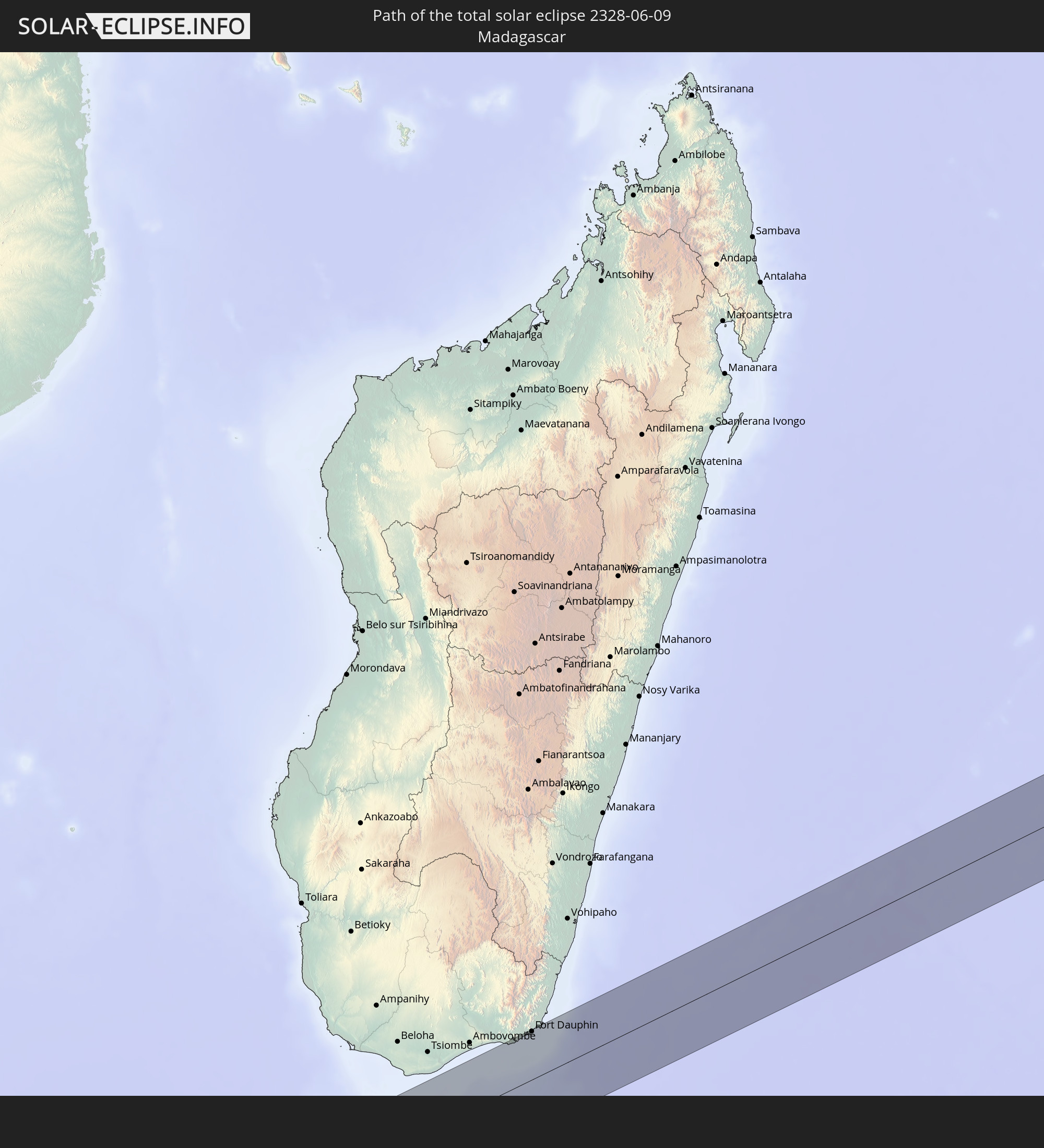
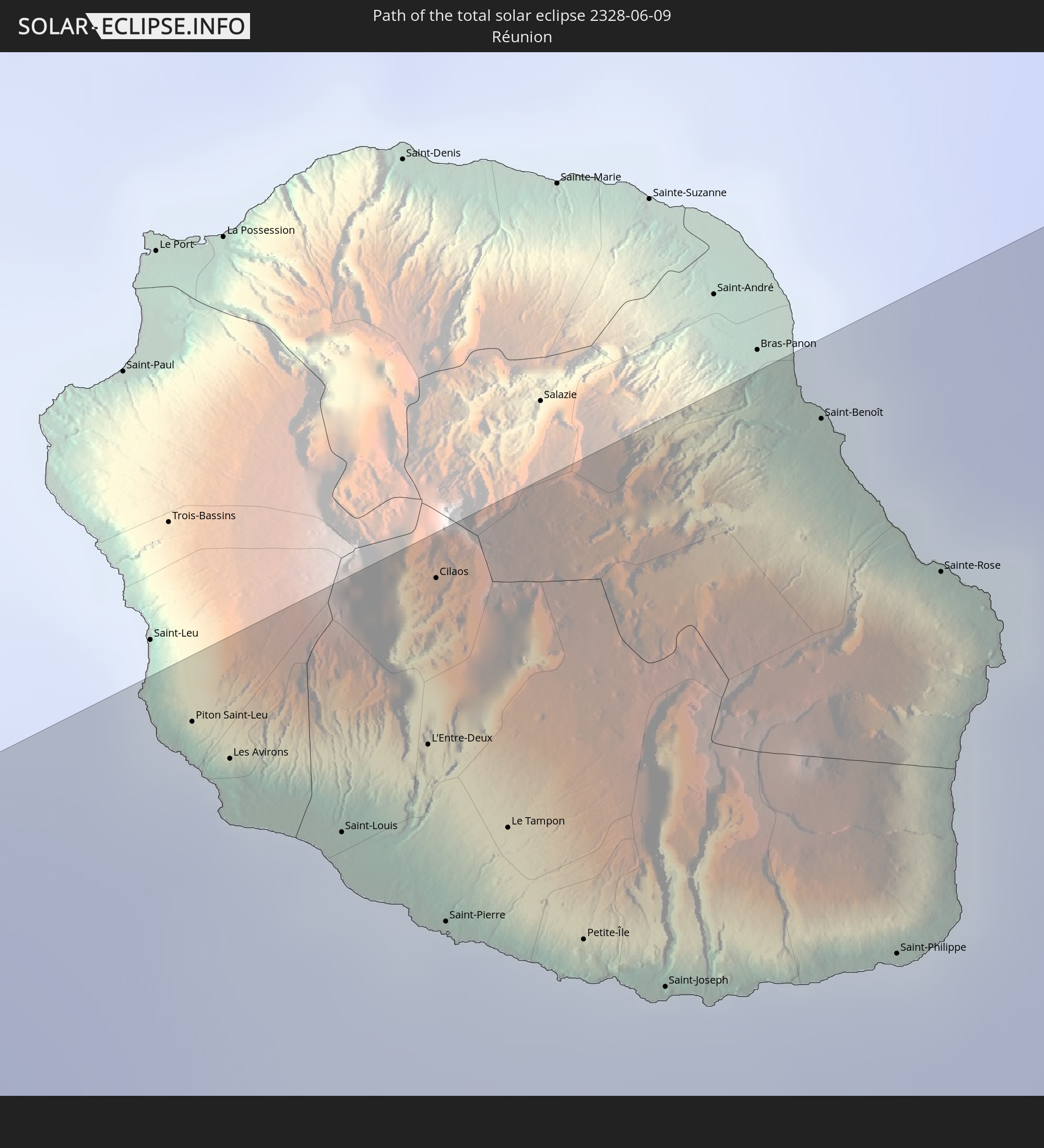
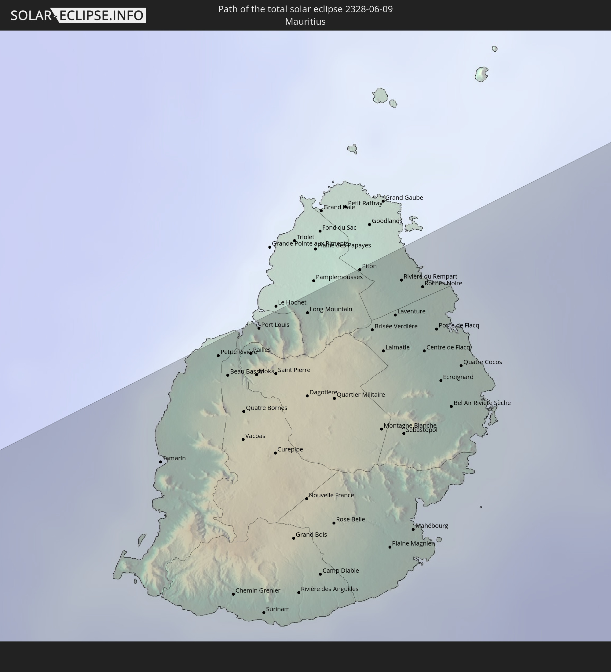
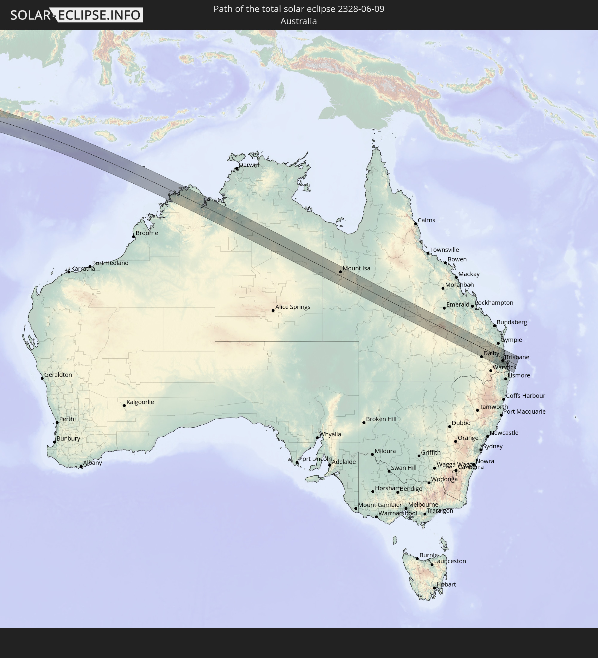
Detaillierte Länderkarten
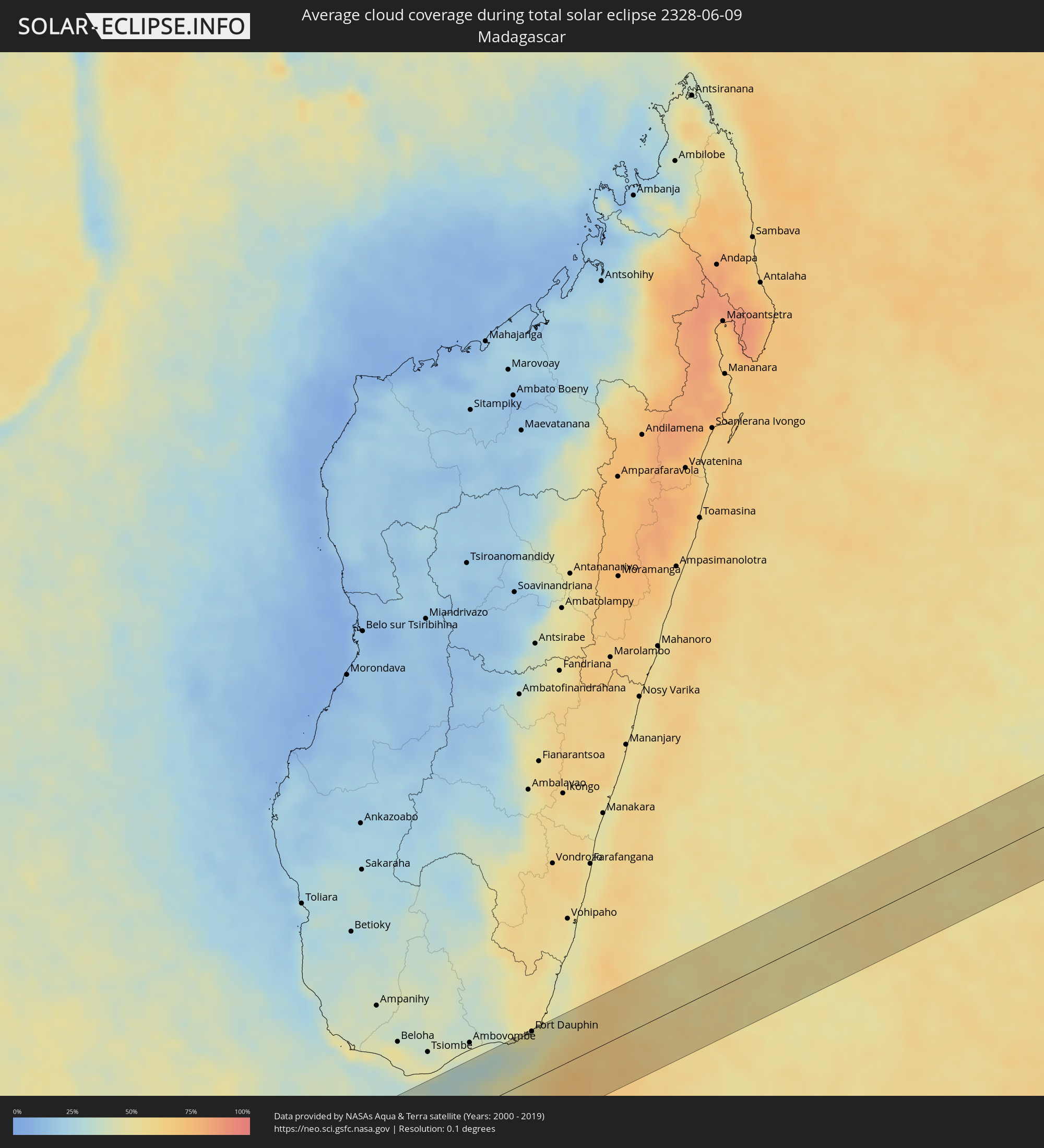 Madagaskar
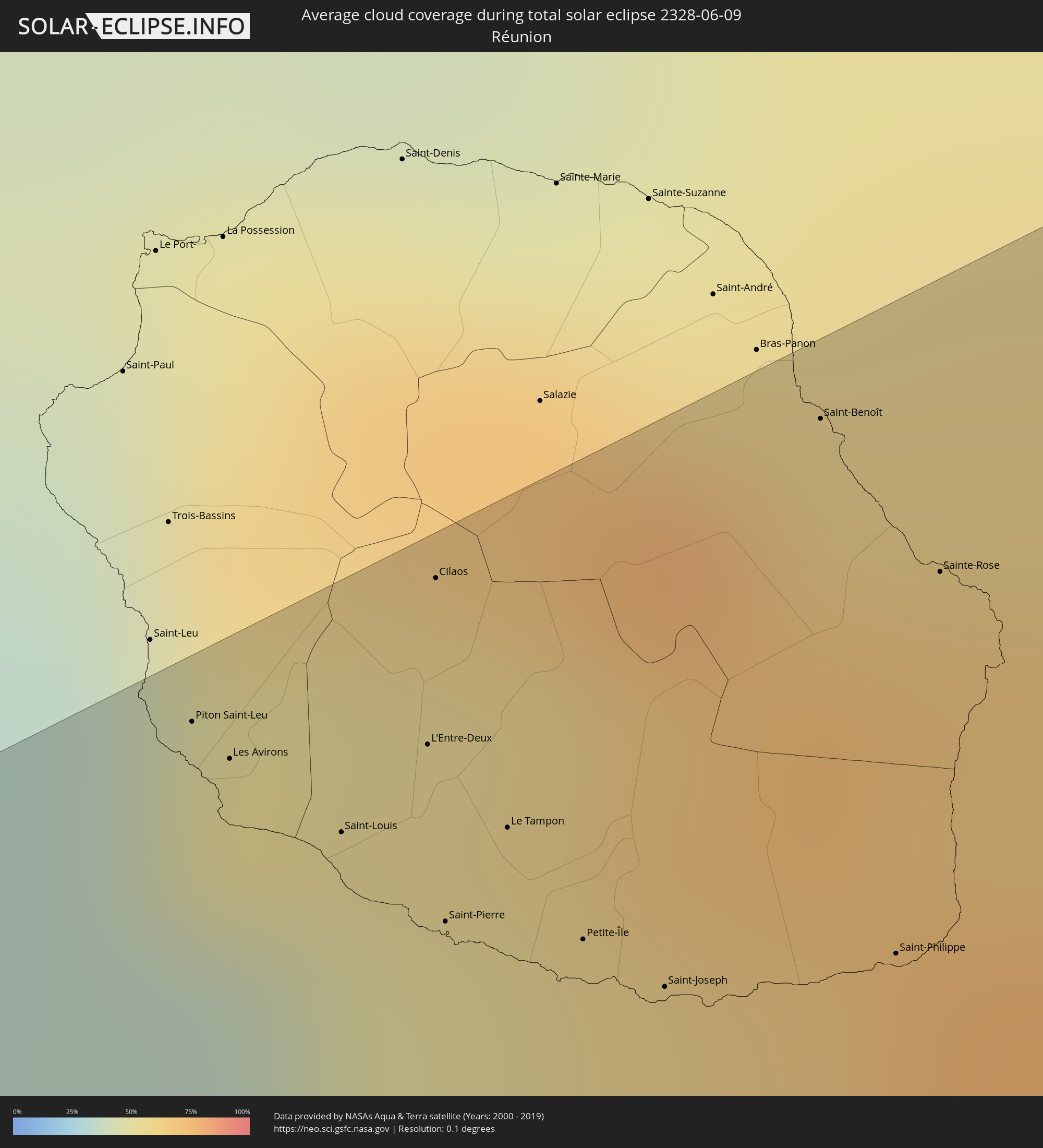 Réunion
 Mauritius
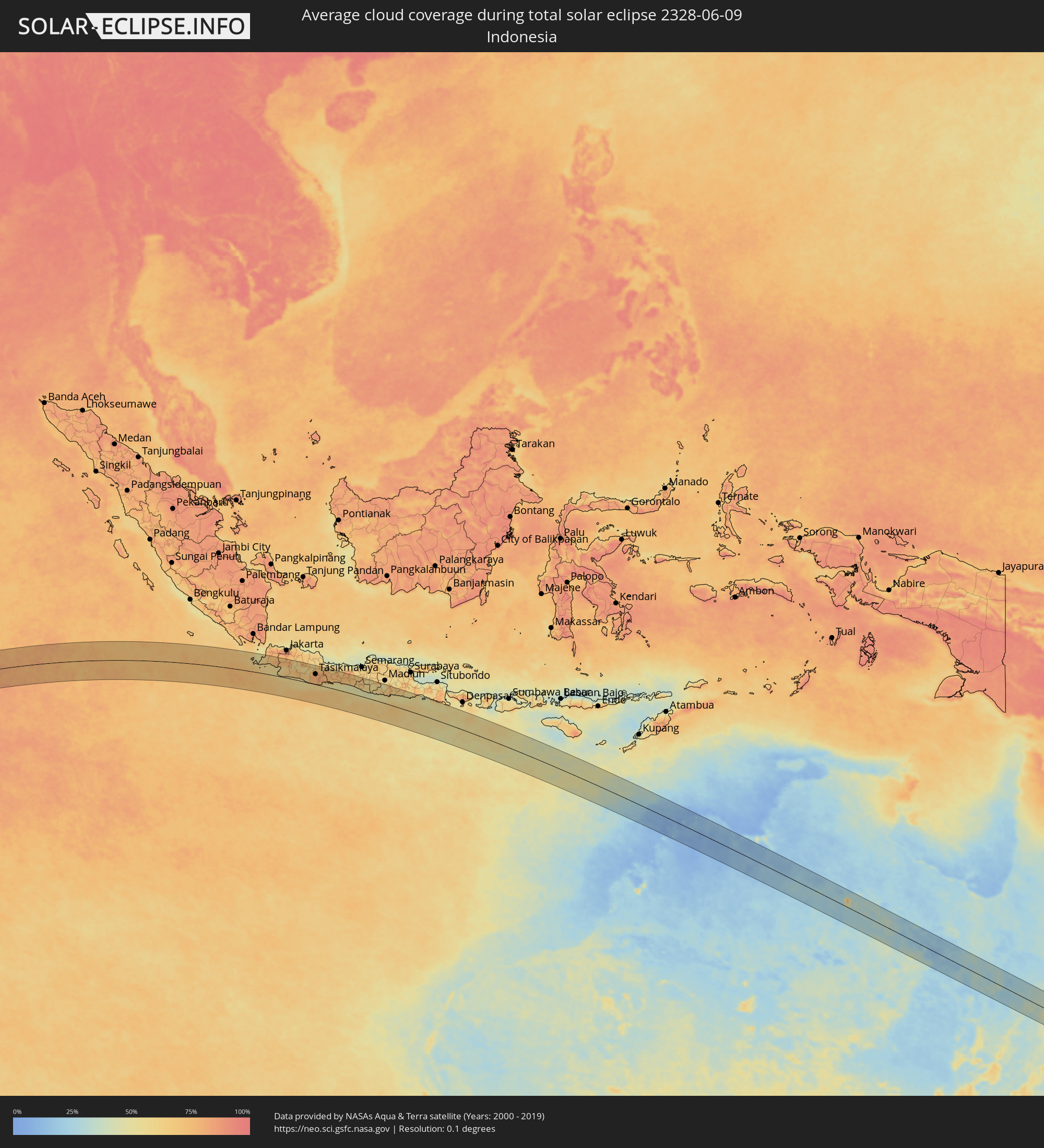 Indonesien
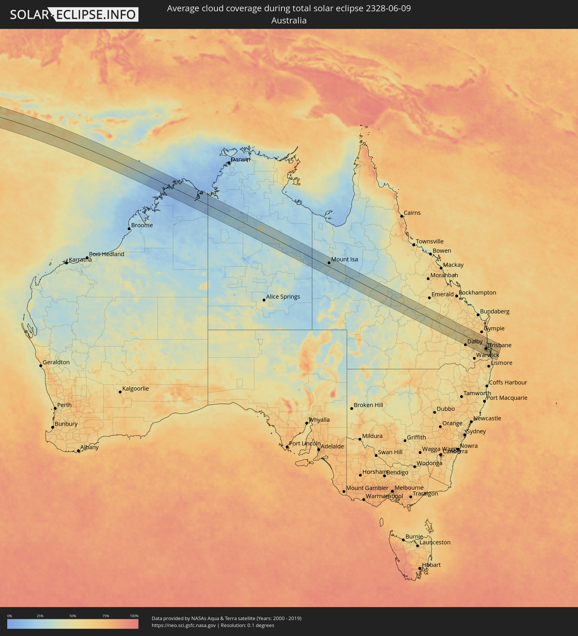 Australien
Orte im Finsternispfad
Die nachfolgene Tabelle zeigt Städte und Orte mit mehr als 5.000 Einwohnern, die sich im Finsternispfad befinden. Städte mit mehr als 100.000 Einwohnern sind dick gekennzeichnet. Mit einem Klick auf den Ort öffnet sich eine Detailkarte die die Lage des jeweiligen Ortes zusammen mit dem Verlauf der zentralen Finsternis präsentiert.
| Ort | Typ | Dauer der Verfinsterung | Ortszeit bei maximaler Verfinsterung | Entfernung zur Zentrallinie | Ø Bewölkung |
|
Fort Dauphin, Anosy
|
total | - | 06:48:43 UTC+03:00 | 63 km | 46% |
|
Piton Saint-Leu, Réunion
|
total | - | 07:50:57 UTC+04:00 | 67 km | 38% |
|
Les Avirons, Réunion
|
total | - | 07:50:58 UTC+04:00 | 63 km | 38% |
|
Saint-Louis, Réunion
|
total | - | 07:51:02 UTC+04:00 | 56 km | 41% |
|
L'Entre-Deux, Réunion
|
total | - | 07:51:03 UTC+04:00 | 58 km | 54% |
|
Cilaos, Réunion
|
total | - | 07:51:01 UTC+04:00 | 68 km | 58% |
|
Saint-Pierre, Réunion
|
total | - | 07:51:06 UTC+04:00 | 47 km | 46% |
|
Le Tampon, Réunion
|
total | - | 07:51:07 UTC+04:00 | 51 km | 46% |
|
Petite-Île, Réunion
|
total | - | 07:51:10 UTC+04:00 | 42 km | 50% |
|
Saint-Joseph, Réunion
|
total | - | 07:51:13 UTC+04:00 | 37 km | 50% |
|
Saint-Benoît, Réunion
|
total | - | 07:51:09 UTC+04:00 | 66 km | 63% |
|
Saint-Philippe, Réunion
|
total | - | 07:51:19 UTC+04:00 | 32 km | 61% |
|
Sainte-Rose, Réunion
|
total | - | 07:51:14 UTC+04:00 | 53 km | 68% |
|
Tamarin, Black River
|
total | - | 07:52:03 UTC+04:00 | 60 km | 59% |
|
Petite Rivière, Black River
|
total | - | 07:52:04 UTC+04:00 | 70 km | 56% |
|
Beau Bassin, Plaines Wilhems
|
total | - | 07:52:05 UTC+04:00 | 67 km | 67% |
|
Chemin Grenier, Savanne
|
total | - | 07:52:11 UTC+04:00 | 40 km | 61% |
|
Vacoas, Plaines Wilhems
|
total | - | 07:52:07 UTC+04:00 | 58 km | 74% |
|
Quatre Bornes, Plaines Wilhems
|
total | - | 07:52:07 UTC+04:00 | 62 km | 74% |
|
Pailles, Moka
|
total | - | 07:52:05 UTC+04:00 | 68 km | 67% |
|
Moka, Moka
|
total | - | 07:52:06 UTC+04:00 | 65 km | 67% |
|
Port Louis, Port Louis
|
total | - | 07:52:05 UTC+04:00 | 71 km | 67% |
|
Surinam, Savanne
|
total | - | 07:52:13 UTC+04:00 | 36 km | 61% |
|
Souillac, Savanne
|
total | - | 07:52:14 UTC+04:00 | 35 km | 61% |
|
Curepipe, Plaines Wilhems
|
total | - | 07:52:10 UTC+04:00 | 55 km | 74% |
|
Saint Pierre, Moka
|
total | - | 07:52:07 UTC+04:00 | 64 km | 67% |
|
Grand Bois, Savanne
|
total | - | 07:52:13 UTC+04:00 | 43 km | 75% |
|
Rivière des Anguilles, Savanne
|
total | - | 07:52:15 UTC+04:00 | 36 km | 64% |
|
Nouvelle France, Grand Port
|
total | - | 07:52:13 UTC+04:00 | 47 km | 76% |
|
Dagotière, Moka
|
total | - | 07:52:10 UTC+04:00 | 60 km | 79% |
|
Long Mountain, Pamplemousses
|
total | - | 07:52:08 UTC+04:00 | 70 km | 68% |
|
Camp Diable, Savanne
|
total | - | 07:52:16 UTC+04:00 | 37 km | 64% |
|
Rose Belle, Grand Port
|
total | - | 07:52:15 UTC+04:00 | 42 km | 76% |
|
Quartier Militaire, Moka
|
total | - | 07:52:12 UTC+04:00 | 58 km | 79% |
|
New Grove, Grand Port
|
total | - | 07:52:16 UTC+04:00 | 41 km | 76% |
|
Piton, Rivière du Rempart
|
total | - | 07:52:10 UTC+04:00 | 72 km | 68% |
|
Brisée Verdière, Flacq
|
total | - | 07:52:12 UTC+04:00 | 64 km | 79% |
|
Bon Accueil, Flacq
|
total | - | 07:52:13 UTC+04:00 | 63 km | 77% |
|
Montagne Blanche
|
total | - | 07:52:15 UTC+04:00 | 51 km | 74% |
|
Lalmatie, Flacq
|
total | - | 07:52:13 UTC+04:00 | 60 km | 77% |
|
Plaine Magnien, Grand Port
|
total | - | 07:52:19 UTC+04:00 | 36 km | 67% |
|
Laventure, Flacq
|
total | - | 07:52:13 UTC+04:00 | 64 km | 68% |
|
Rivière du Rempart, Rivière du Rempart
|
total | - | 07:52:12 UTC+04:00 | 68 km | 68% |
|
Sebastopol, Flacq
|
total | - | 07:52:17 UTC+04:00 | 49 km | 74% |
|
Beau Vallon, Grand Port
|
total | - | 07:52:20 UTC+04:00 | 36 km | 67% |
|
Mahébourg, Grand Port
|
total | - | 07:52:20 UTC+04:00 | 37 km | 67% |
|
Roches Noire, Rivière du Rempart
|
total | - | 07:52:14 UTC+04:00 | 66 km | 68% |
|
Centre de Flacq, Flacq
|
total | - | 07:52:16 UTC+04:00 | 58 km | 77% |
|
Poste de Flacq, Flacq
|
total | - | 07:52:16 UTC+04:00 | 60 km | 77% |
|
Ecroignard, Flacq
|
total | - | 07:52:18 UTC+04:00 | 53 km | 77% |
|
Bel Air Rivière Sèche, Flacq
|
total | - | 07:52:19 UTC+04:00 | 50 km | 74% |
|
Quatre Cocos, Flacq
|
total | - | 07:52:18 UTC+04:00 | 54 km | 63% |
|
Pelabuhanratu, West Java
|
total | - | 12:43:32 UTC+07:00 | 50 km | 56% |
|
Caringin, West Java
|
total | - | 12:44:20 UTC+07:00 | 87 km | 72% |
|
Sukabumi, West Java
|
total | - | 12:44:42 UTC+07:00 | 66 km | 67% |
|
Ciranjang-hilir, West Java
|
total | - | 12:45:43 UTC+07:00 | 84 km | 59% |
|
Banjar, West Java
|
total | - | 12:46:19 UTC+07:00 | 47 km | 74% |
|
Padalarang, West Java
|
total | - | 12:46:23 UTC+07:00 | 87 km | 67% |
|
Soreang, West Java
|
total | - | 12:46:33 UTC+07:00 | 67 km | 58% |
|
Pameungpeuk, West Java
|
total | - | 12:46:49 UTC+07:00 | 71 km | 56% |
|
Bandung, West Java
|
total | - | 12:46:49 UTC+07:00 | 81 km | 58% |
|
Cileunyi, West Java
|
total | - | 12:47:16 UTC+07:00 | 83 km | 59% |
|
Paseh, West Java
|
total | - | 12:47:20 UTC+07:00 | 65 km | 65% |
|
Sumedang Utara
|
total | - | 12:47:45 UTC+07:00 | 97 km | 69% |
|
Singaparna, West Java
|
total | - | 12:48:26 UTC+07:00 | 47 km | 78% |
|
Rajapolah, West Java
|
total | - | 12:48:39 UTC+07:00 | 63 km | 78% |
|
Kawalu, West Java
|
total | - | 12:48:44 UTC+07:00 | 46 km | 80% |
|
Tasikmalaya, West Java
|
total | - | 12:48:46 UTC+07:00 | 52 km | 78% |
|
Kuningan, West Java
|
total | - | 12:49:30 UTC+07:00 | 97 km | 64% |
|
Majenang, Central Java
|
total | - | 12:50:24 UTC+07:00 | 70 km | 77% |
|
Wangon, Central Java
|
total | - | 12:51:19 UTC+07:00 | 54 km | 68% |
|
Baturaden, Central Java
|
total | - | 12:51:46 UTC+07:00 | 81 km | 77% |
|
Purwokerto, Central Java
|
total | - | 12:51:50 UTC+07:00 | 69 km | 74% |
|
Banyumas, Central Java
|
total | - | 12:52:02 UTC+07:00 | 61 km | 71% |
|
Wonosobo, Central Java
|
total | - | 12:53:48 UTC+07:00 | 94 km | 72% |
|
Magelang, Central Java
|
total | - | 12:54:45 UTC+07:00 | 91 km | 63% |
|
Bambanglipuro, Yogyakarta
|
total | - | 12:55:02 UTC+07:00 | 42 km | 45% |
|
Muntilan, Central Java
|
total | - | 12:54:59 UTC+07:00 | 82 km | 65% |
|
Pandak, Yogyakarta
|
total | - | 12:55:03 UTC+07:00 | 46 km | 55% |
|
Sleman, Yogyakarta
|
total | - | 12:55:12 UTC+07:00 | 69 km | 67% |
|
Yogyakarta, Yogyakarta
|
total | - | 12:55:14 UTC+07:00 | 60 km | 64% |
|
Candi Prambanan, Central Java
|
total | - | 12:55:36 UTC+07:00 | 70 km | 62% |
|
Wedi, Central Java
|
total | - | 12:55:51 UTC+07:00 | 73 km | 57% |
|
Klaten, Central Java
|
total | - | 12:55:55 UTC+07:00 | 78 km | 57% |
|
Karanganom, Central Java
|
total | - | 12:55:58 UTC+07:00 | 85 km | 58% |
|
Gatak, Central Java
|
total | - | 12:56:11 UTC+07:00 | 93 km | 59% |
|
Grogol, Central Java
|
total | - | 12:56:31 UTC+07:00 | 95 km | 58% |
|
Jatiroto, Central Java
|
total | - | 12:57:25 UTC+07:00 | 75 km | 61% |
|
Ponorogo, East Java
|
total | - | 12:58:24 UTC+07:00 | 87 km | 54% |
|
Kedungwaru, East Java
|
total | - | 12:59:43 UTC+07:00 | 81 km | 64% |
|
Blitar, East Java
|
total | - | 13:00:25 UTC+07:00 | 85 km | 66% |
|
Sumberpucung, East Java
|
total | - | 13:01:18 UTC+07:00 | 90 km | 59% |
|
Mount Isa, Queensland
|
total | - | 16:47:22 UTC+10:00 | 28 km | 29% |
|
Kingaroy, Queensland
|
total | - | 16:51:54 UTC+10:00 | 20 km | 63% |
|
Gatton, Queensland
|
total | - | 16:51:27 UTC+10:00 | 63 km | 58% |
|
Brassall, Queensland
|
total | - | 16:51:35 UTC+10:00 | 46 km | 59% |
|
Raceview, Queensland
|
total | - | 16:51:34 UTC+10:00 | 48 km | 60% |
|
Booval, Queensland
|
total | - | 16:51:35 UTC+10:00 | 45 km | 60% |
|
Samford Valley, Queensland
|
total | - | 16:51:45 UTC+10:00 | 18 km | 60% |
|
Goodna, Queensland
|
total | - | 16:51:37 UTC+10:00 | 40 km | 60% |
|
Springfield, Queensland
|
total | - | 16:51:36 UTC+10:00 | 44 km | 58% |
|
Ferny Hills, Queensland
|
total | - | 16:51:46 UTC+10:00 | 17 km | 60% |
|
Caboolture, Queensland
|
total | - | 16:51:57 UTC+10:00 | 14 km | 58% |
|
Burpengary, Queensland
|
total | - | 16:51:55 UTC+10:00 | 7 km | 59% |
|
Nambour, Queensland
|
total | - | 16:52:13 UTC+10:00 | 61 km | 65% |
|
Taringa, Queensland
|
total | - | 16:51:43 UTC+10:00 | 25 km | 62% |
|
Everton Park, Queensland
|
total | - | 16:51:46 UTC+10:00 | 16 km | 64% |
|
Bridegman Downs, Queensland
|
total | - | 16:51:48 UTC+10:00 | 11 km | 64% |
|
Stafford Heights, Queensland
|
total | - | 16:51:47 UTC+10:00 | 14 km | 64% |
|
Stafford, Queensland
|
total | - | 16:51:47 UTC+10:00 | 15 km | 64% |
|
Chermside West, Queensland
|
total | - | 16:51:48 UTC+10:00 | 13 km | 64% |
|
Brisbane, Queensland
|
total | - | 16:51:45 UTC+10:00 | 20 km | 62% |
|
Windsor, Queensland
|
total | - | 16:51:46 UTC+10:00 | 17 km | 64% |
|
Bracken Ridge, Queensland
|
total | - | 16:51:50 UTC+10:00 | 5 km | 65% |
|
Zillmere, Queensland
|
total | - | 16:51:49 UTC+10:00 | 9 km | 64% |
|
Greenslopes, Queensland
|
total | - | 16:51:44 UTC+10:00 | 24 km | 62% |
|
Brighton, Queensland
|
total | - | 16:51:51 UTC+10:00 | 2 km | 61% |
|
Clontarf, Queensland
|
total | - | 16:51:53 UTC+10:00 | 3 km | 61% |
|
Upper Mount Gravatt, Queensland
|
total | - | 16:51:42 UTC+10:00 | 27 km | 61% |
|
Margate, Queensland
|
total | - | 16:51:54 UTC+10:00 | 5 km | 54% |
|
Mansfield, Queensland
|
total | - | 16:51:43 UTC+10:00 | 24 km | 62% |
|
Logan City, Queensland
|
total | - | 16:51:40 UTC+10:00 | 34 km | 61% |
|
Mooloolaba, Queensland
|
total | - | 16:52:14 UTC+10:00 | 62 km | 63% |
|
Caloundra, Queensland
|
total | - | 16:52:10 UTC+10:00 | 50 km | 59% |
|
Springwood, Queensland
|
total | - | 16:51:41 UTC+10:00 | 30 km | 61% |
|
Waterford West, Queensland
|
total | - | 16:51:39 UTC+10:00 | 38 km | 60% |
|
Bongaree, Queensland
|
total | - | 16:52:01 UTC+10:00 | 24 km | 53% |
|
Tamborine Mountain, Queensland
|
total | - | 16:51:30 UTC+10:00 | 63 km | 60% |
|
Beenleigh, Queensland
|
total | - | 16:51:39 UTC+10:00 | 37 km | 60% |
|
Cleveland, Queensland
|
total | - | 16:51:47 UTC+10:00 | 16 km | 58% |
|
Oxenford, Queensland
|
total | - | 16:51:34 UTC+10:00 | 50 km | 61% |
|
Gold Coast, Queensland
|
total | - | 16:51:32 UTC+10:00 | 56 km | 56% |