Totale Sonnenfinsternis vom 02.11.2339
| Wochentag: | Donnerstag |
| Maximale Dauer der Verfinsterung: | 03m47s |
| Maximale Breite des Finsternispfades: | 215 km |
| Saroszyklus: | 158 |
| Bedeckungsgrad: | 100% |
| Magnitude: | 1.0536 |
| Gamma: | -0.5751 |
Wo kann man die Sonnenfinsternis vom 02.11.2339 sehen?
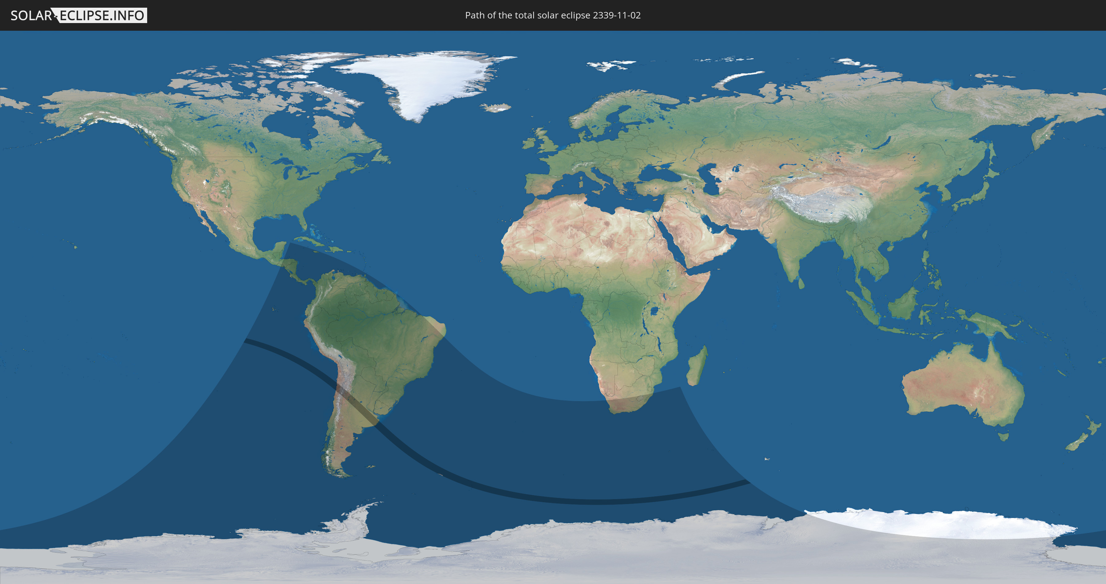
Die Sonnenfinsternis am 02.11.2339 kann man in 30 Ländern als partielle Sonnenfinsternis beobachten.
Der Finsternispfad verläuft durch 3 Länder. Nur in diesen Ländern ist sie als totale Sonnenfinsternis zu sehen.
In den folgenden Ländern ist die Sonnenfinsternis total zu sehen
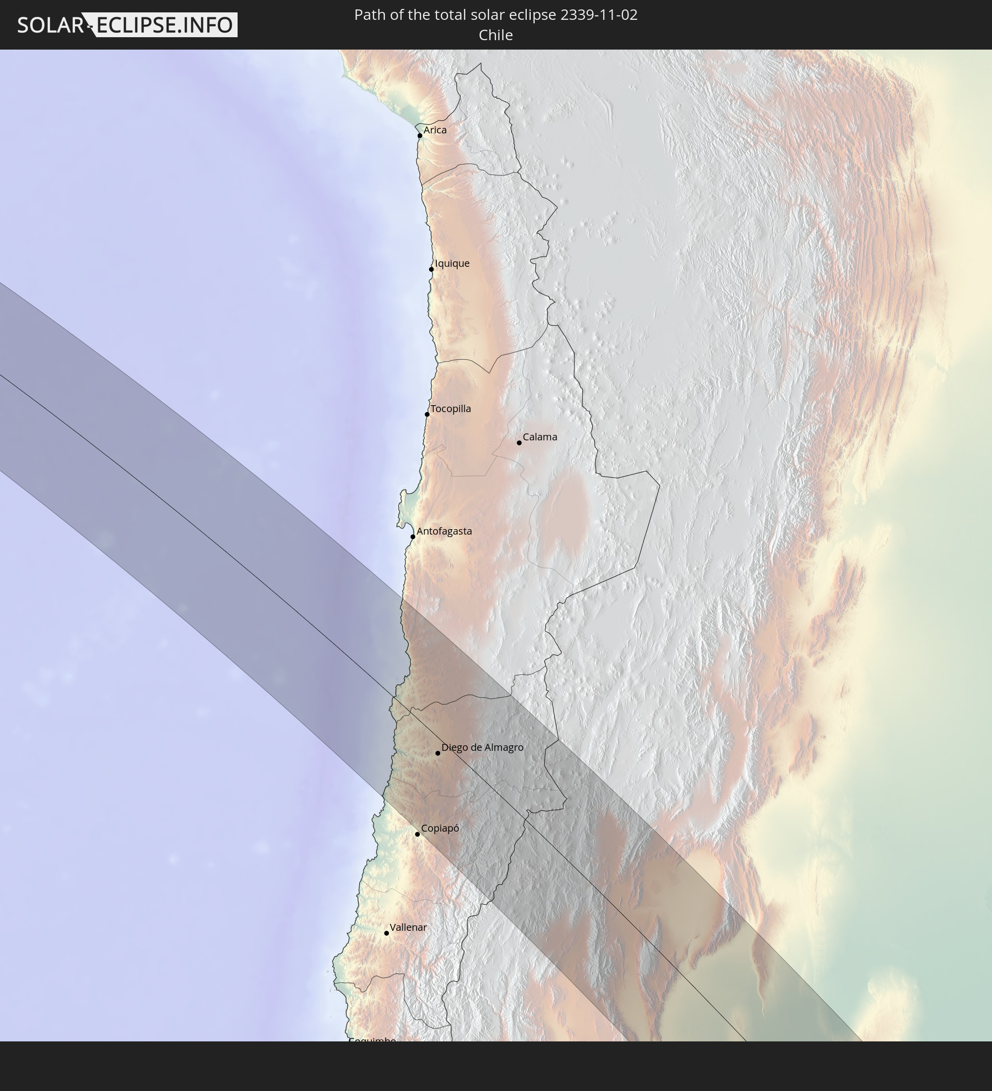 Chile
Chile
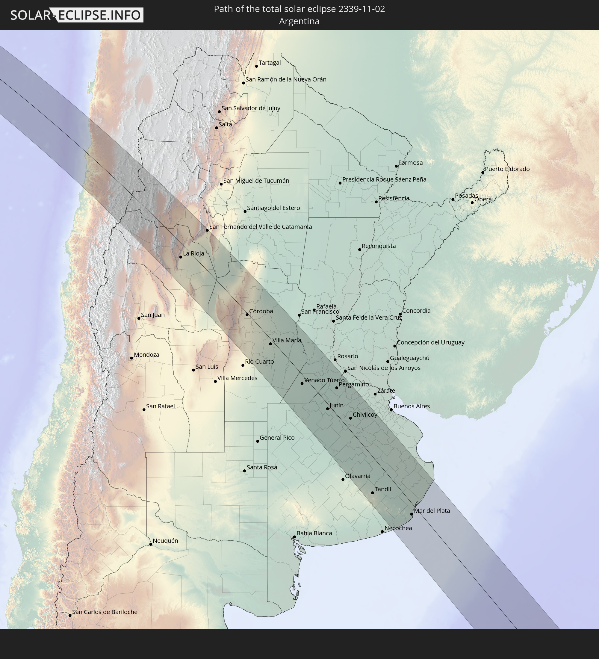 Argentinien
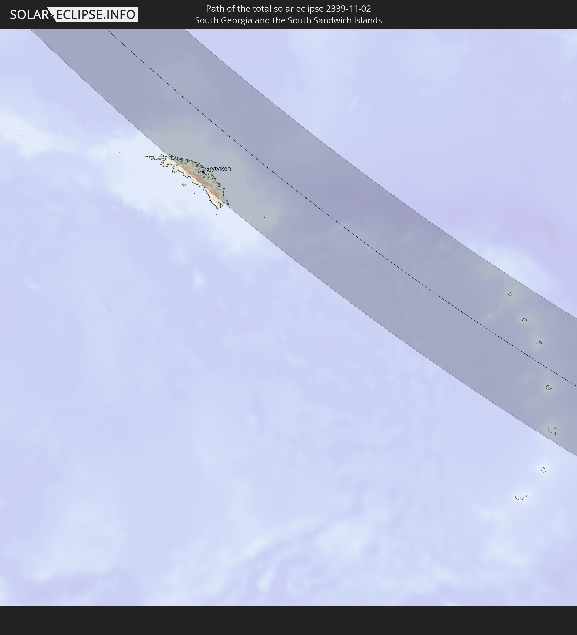 Südgeorgien und die Südlichen Sandwichinseln
In den folgenden Ländern ist die Sonnenfinsternis partiell zu sehen
 Antarktika
 Chile
Chile
 Ecuador
 El Salvador
 Honduras
 Nicaragua
 Costa Rica
 Panama
 Kolumbien
 Kaimaninseln
 Peru
Peru
 Jamaika
 Brasilien
 Argentinien
 Venezuela
 Aruba
Aruba
 Bolivien
 Paraguay
 Trinidad und Tobago
 Falklandinseln
 Guyana
 Uruguay
 Suriname
 Französisch-Guayana
 Südgeorgien und die Südlichen Sandwichinseln
 St. Helena
 Bouvetinsel
 Südafrika
 Lesotho
 Französische Süd- und Antarktisgebiete
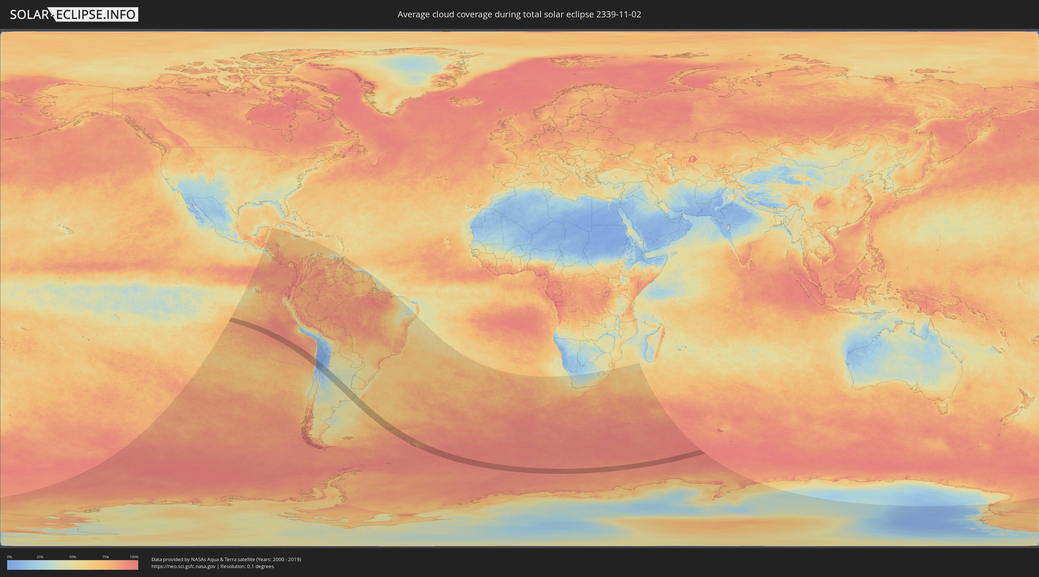
Wie wird das Wetter während der totalen Sonnenfinsternis am 02.11.2339?
Wo ist der beste Ort, um die totale Sonnenfinsternis vom 02.11.2339 zu beobachten?
Die folgenden Karten zeigen die durchschnittliche Bewölkung für den Tag, an dem die totale Sonnenfinsternis
stattfindet. Mit Hilfe der Karten lässt sich der Ort entlang des Finsternispfades eingrenzen,
der die besten Aussichen auf einen klaren wolkenfreien Himmel bietet.
Trotzdem muss man immer lokale Gegenenheiten beachten und sollte sich genau über das Wetter an seinem
gewählten Beobachtungsort informieren.
Die Daten stammen von den beiden NASA-Satelliten
AQUA und TERRA
und wurden über einen Zeitraum von 19 Jahren (2000 - 2019) gemittelt.

Detaillierte Länderkarten
 Chile
Chile
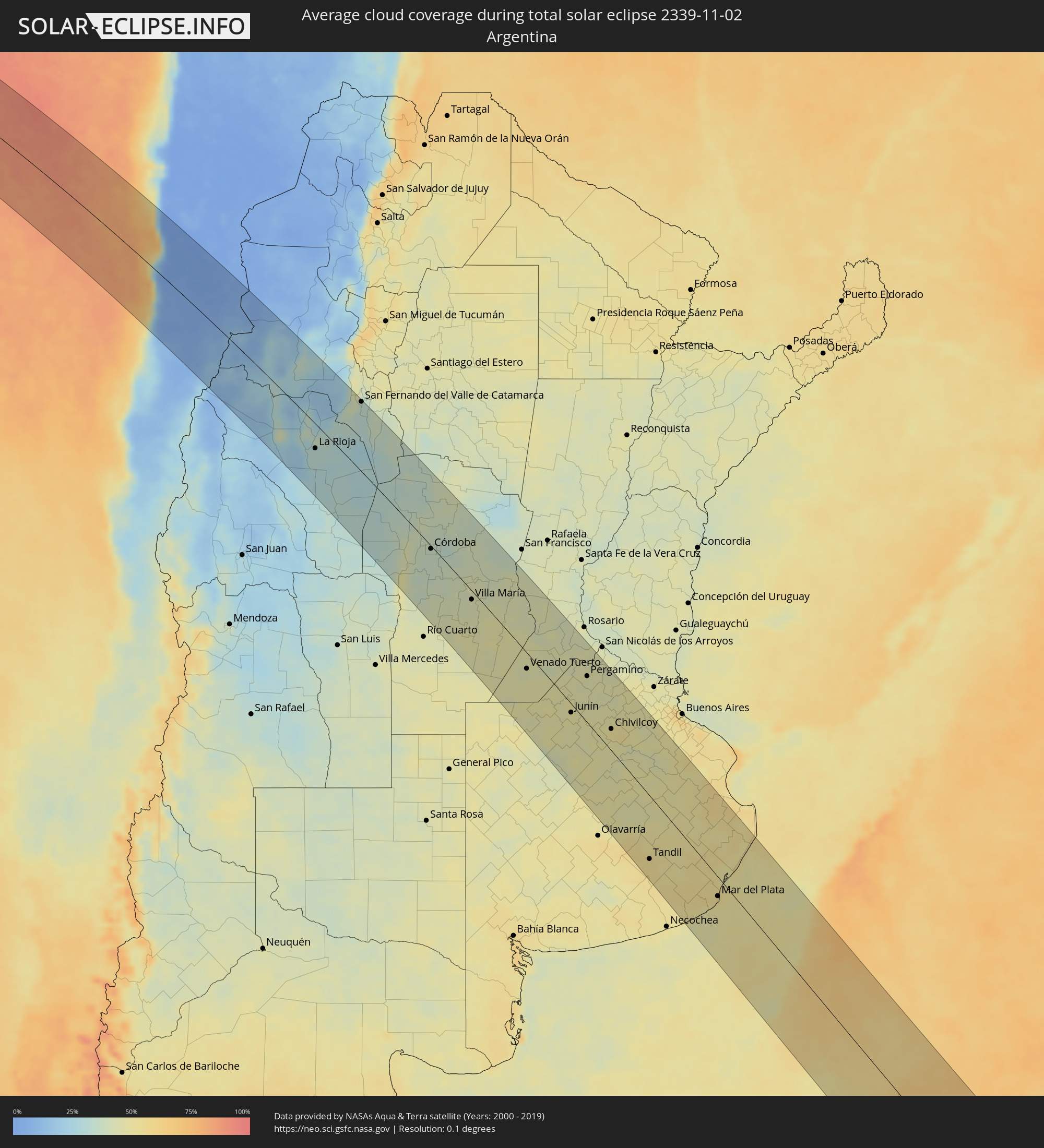 Argentinien
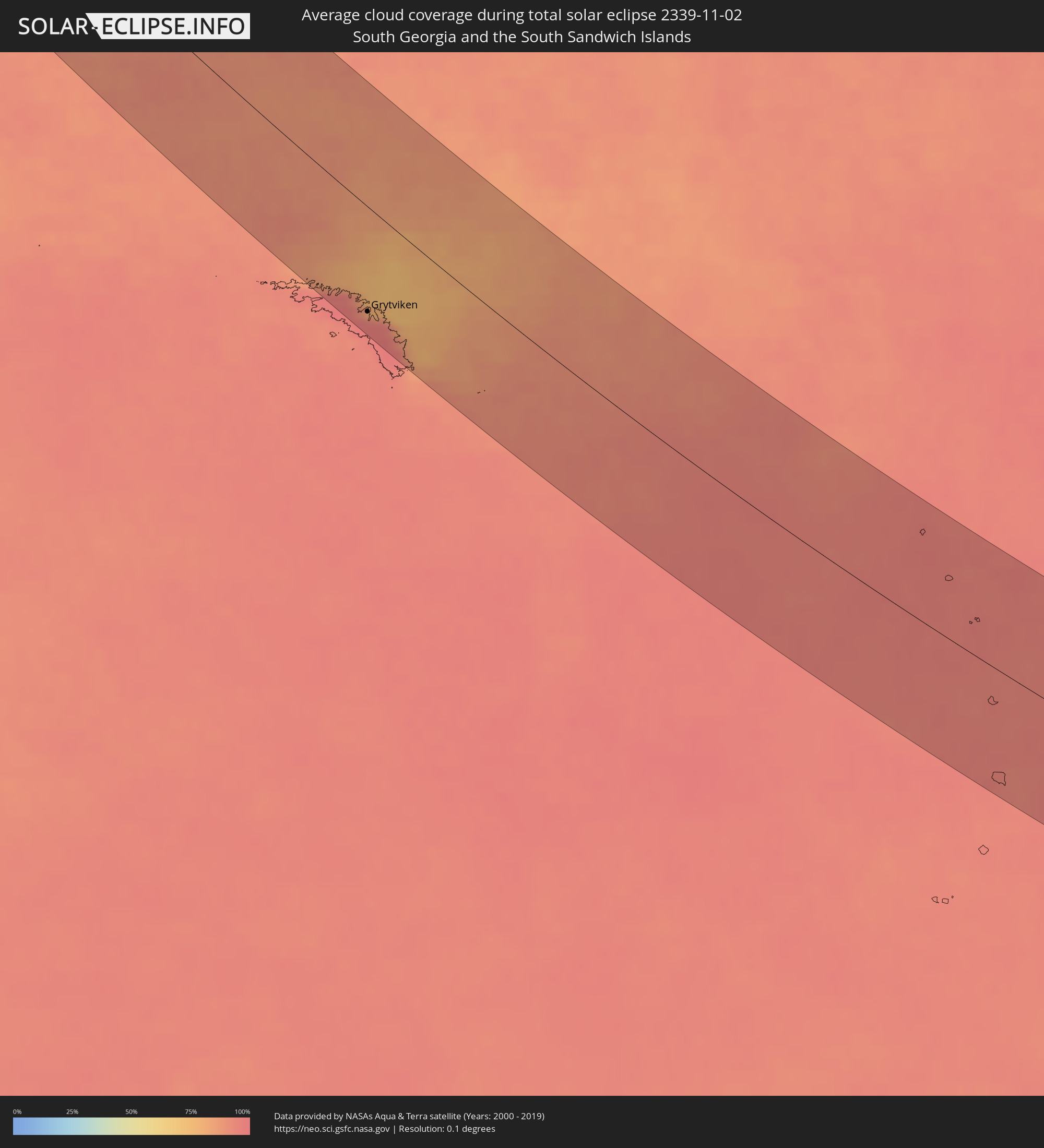 Südgeorgien und die Südlichen Sandwichinseln
Orte im Finsternispfad
Die nachfolgene Tabelle zeigt Städte und Orte mit mehr als 5.000 Einwohnern, die sich im Finsternispfad befinden. Städte mit mehr als 100.000 Einwohnern sind dick gekennzeichnet. Mit einem Klick auf den Ort öffnet sich eine Detailkarte die die Lage des jeweiligen Ortes zusammen mit dem Verlauf der zentralen Finsternis präsentiert.
| Ort | Typ | Dauer der Verfinsterung | Ortszeit bei maximaler Verfinsterung | Entfernung zur Zentrallinie | Ø Bewölkung |
|
Taltal, Antofagasta
|
total | - | 09:38:55 UTC-03:00 | 33 km | 43% |
|
Diego de Almagro, Atacama
|
total | - | 09:40:54 UTC-03:00 | 16 km | 4% |
|
Fiambalá, Catamarca Province
|
total | - | 09:44:56 UTC-03:00 | 44 km | 16% |
|
Tinogasta, Catamarca Province
|
total | - | 09:45:40 UTC-03:00 | 18 km | 26% |
|
Chilecito, La Rioja Province
|
total | - | 09:47:44 UTC-03:00 | 64 km | 25% |
|
La Rioja, La Rioja Province
|
total | - | 09:48:40 UTC-03:00 | 38 km | 32% |
|
Arauco, La Rioja Province
|
total | - | 09:47:11 UTC-03:00 | 30 km | 19% |
|
Chamical, La Rioja Province
|
total | - | 09:50:51 UTC-03:00 | 74 km | 33% |
|
San Fernando del Valle de Catamarca, Catamarca Province
|
total | - | 09:47:45 UTC-03:00 | 109 km | 34% |
|
Recreo, Catamarca Province
|
total | - | 09:49:50 UTC-03:00 | 97 km | 37% |
|
Cruz del Eje, Cordoba Province
|
total | - | 09:52:45 UTC-03:00 | 4 km | 35% |
|
Santa Rosa de Calamuchita, Cordoba Province
|
total | - | 09:55:30 UTC-03:00 | 78 km | 39% |
|
Capilla del Monte, Cordoba Province
|
total | - | 09:53:14 UTC-03:00 | 13 km | 39% |
|
Villa Carlos Paz, Cordoba Province
|
total | - | 09:54:19 UTC-03:00 | 27 km | 37% |
|
La Falda, Cordoba Province
|
total | - | 09:53:42 UTC-03:00 | 2 km | 39% |
|
Cosquín, Cordoba Province
|
total | - | 09:54:01 UTC-03:00 | 12 km | 38% |
|
Alta Gracia, Cordoba Province
|
total | - | 09:54:49 UTC-03:00 | 40 km | 36% |
|
Embalse, Cordoba Province
|
total | - | 09:55:49 UTC-03:00 | 78 km | 37% |
|
Malagueño, Cordoba Province
|
total | - | 09:54:31 UTC-03:00 | 21 km | 37% |
|
Deán Funes, Cordoba Province
|
total | - | 09:52:33 UTC-03:00 | 59 km | 36% |
|
La Calera, Cordoba Province
|
total | - | 09:54:18 UTC-03:00 | 10 km | 37% |
|
Río Ceballos, Cordoba Province
|
total | - | 09:53:59 UTC-03:00 | 5 km | 38% |
|
Unquillo, Cordoba Province
|
total | - | 09:54:07 UTC-03:00 | 1 km | 38% |
|
Villa Allende, Cordoba Province
|
total | - | 09:54:15 UTC-03:00 | 3 km | 37% |
|
Almafuerte, Cordoba Province
|
total | - | 09:55:58 UTC-03:00 | 68 km | 39% |
|
Córdoba, Cordoba Province
|
total | - | 09:54:34 UTC-03:00 | 4 km | 37% |
|
Río Tercero, Cordoba Province
|
total | - | 09:56:03 UTC-03:00 | 56 km | 39% |
|
Jesús María, Cordoba Province
|
total | - | 09:53:50 UTC-03:00 | 34 km | 37% |
|
Malvinas Argentinas, Cordoba Province
|
total | - | 09:54:36 UTC-03:00 | 6 km | 36% |
|
Río Segundo, Cordoba Province
|
total | - | 09:55:15 UTC-03:00 | 3 km | 38% |
|
Pilar, Cordoba Province
|
total | - | 09:55:20 UTC-03:00 | 3 km | 38% |
|
General Cabrera, Cordoba Province
|
total | - | 09:57:28 UTC-03:00 | 87 km | 43% |
|
Hernando, Cordoba Province
|
total | - | 09:56:52 UTC-03:00 | 49 km | 42% |
|
Oncativo, Cordoba Province
|
total | - | 09:55:56 UTC-03:00 | 7 km | 40% |
|
Oliva, Cordoba Province
|
total | - | 09:56:17 UTC-03:00 | 9 km | 42% |
|
La Carlota, Cordoba Province
|
total | - | 09:59:08 UTC-03:00 | 91 km | 46% |
|
Villa Nueva, Cordoba Province
|
total | - | 09:57:18 UTC-03:00 | 15 km | 43% |
|
Villa María, Cordoba Province
|
total | - | 09:57:16 UTC-03:00 | 13 km | 43% |
|
Arroyito, Cordoba Province
|
total | - | 09:55:34 UTC-03:00 | 74 km | 40% |
|
Canals, Cordoba Province
|
total | - | 09:59:46 UTC-03:00 | 73 km | 47% |
|
Las Varillas, Cordoba Province
|
total | - | 09:56:43 UTC-03:00 | 64 km | 41% |
|
Rufino, Santa Fe Province
|
total | - | 10:01:16 UTC-03:00 | 112 km | 47% |
|
Bell Ville, Cordoba Province
|
total | - | 09:58:10 UTC-03:00 | 10 km | 47% |
|
Leones, Cordoba Province
|
total | - | 09:58:35 UTC-03:00 | 35 km | 45% |
|
Corral de Bustos, Cordoba Province
|
total | - | 09:59:52 UTC-03:00 | 3 km | 47% |
|
Marcos Juárez, Cordoba Province
|
total | - | 09:58:50 UTC-03:00 | 45 km | 42% |
|
Venado Tuerto, Santa Fe Province
|
total | - | 10:00:57 UTC-03:00 | 22 km | 44% |
|
El Trébol, Santa Fe Province
|
total | - | 09:58:15 UTC-03:00 | 110 km | 43% |
|
Villa Cañás, Santa Fe Province
|
total | - | 10:01:47 UTC-03:00 | 16 km | 47% |
|
Armstrong, Santa Fe Province
|
total | - | 09:59:27 UTC-03:00 | 74 km | 44% |
|
Las Rosas, Santa Fe Province
|
total | - | 09:58:54 UTC-03:00 | 98 km | 45% |
|
Lincoln, Buenos Aires
|
total | - | 10:03:29 UTC-03:00 | 73 km | 48% |
|
Las Parejas, Santa Fe Province
|
total | - | 09:59:21 UTC-03:00 | 87 km | 45% |
|
Firmat, Santa Fe Province
|
total | - | 10:00:51 UTC-03:00 | 33 km | 43% |
|
Cañada de Gómez, Santa Fe Province
|
total | - | 09:59:43 UTC-03:00 | 86 km | 43% |
|
Casilda, Santa Fe Province
|
total | - | 10:00:22 UTC-03:00 | 85 km | 43% |
|
Carcarañá, Santa Fe Province
|
total | - | 10:00:01 UTC-03:00 | 100 km | 43% |
|
Junín, Buenos Aires
|
total | - | 10:03:30 UTC-03:00 | 12 km | 48% |
|
Nueve de Julio, Buenos Aires
|
total | - | 10:05:12 UTC-03:00 | 70 km | 49% |
|
Pergamino, Buenos Aires
|
total | - | 10:02:32 UTC-03:00 | 64 km | 44% |
|
Chacabuco, Buenos Aires
|
total | - | 10:04:04 UTC-03:00 | 16 km | 48% |
|
Veinticinco de Mayo, Buenos Aires
|
total | - | 10:05:52 UTC-03:00 | 20 km | 47% |
|
Chivilcoy, Buenos Aires
|
total | - | 10:05:00 UTC-03:00 | 30 km | 51% |
|
Azul, Buenos Aires
|
total | - | 10:08:44 UTC-03:00 | 94 km | 51% |
|
Mercedes, Buenos Aires
|
total | - | 10:05:07 UTC-03:00 | 88 km | 47% |
|
Tandil, Buenos Aires
|
total | - | 10:10:29 UTC-03:00 | 84 km | 54% |
|
Dolores, Buenos Aires
|
total | - | 10:10:04 UTC-03:00 | 88 km | 57% |
|
Mar del Plata, Buenos Aires
|
total | - | 10:13:23 UTC-03:00 | 25 km | 55% |
|
Villa Gesell, Buenos Aires
|
total | - | 10:12:37 UTC-03:00 | 67 km | 52% |
|
Grytviken
|
total | - | 12:03:11 UTC-02:00 | 85 km | 93% |