Totale Sonnenfinsternis vom 23.06.2495
| Wochentag: | Donnerstag |
| Maximale Dauer der Verfinsterung: | 05m39s |
| Maximale Breite des Finsternispfades: | 464 km |
| Saroszyklus: | 164 |
| Bedeckungsgrad: | 100% |
| Magnitude: | 1.0696 |
| Gamma: | -0.8718 |
Wo kann man die Sonnenfinsternis vom 23.06.2495 sehen?

Die Sonnenfinsternis am 23.06.2495 kann man in 22 Ländern als partielle Sonnenfinsternis beobachten.
Der Finsternispfad verläuft durch 2 Länder. Nur in diesen Ländern ist sie als totale Sonnenfinsternis zu sehen.
In den folgenden Ländern ist die Sonnenfinsternis total zu sehen
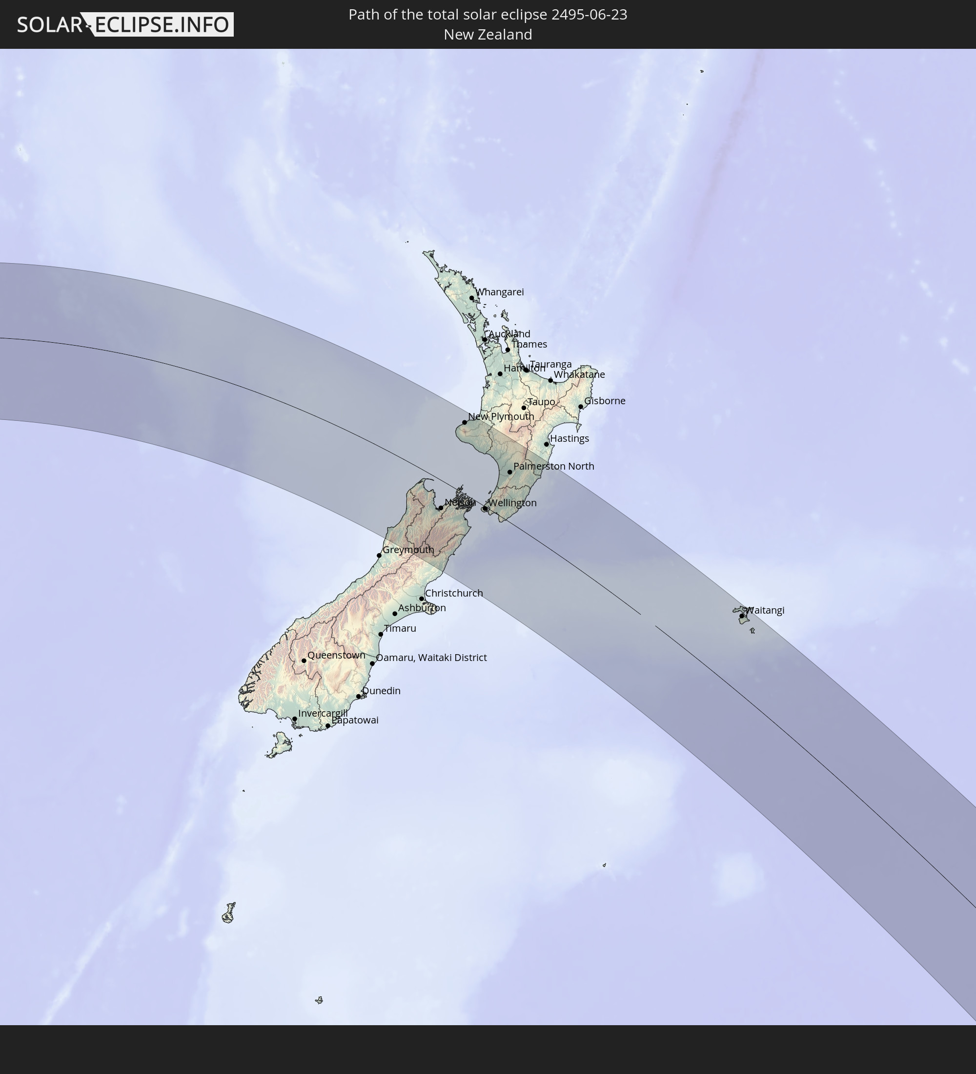 Neuseeland
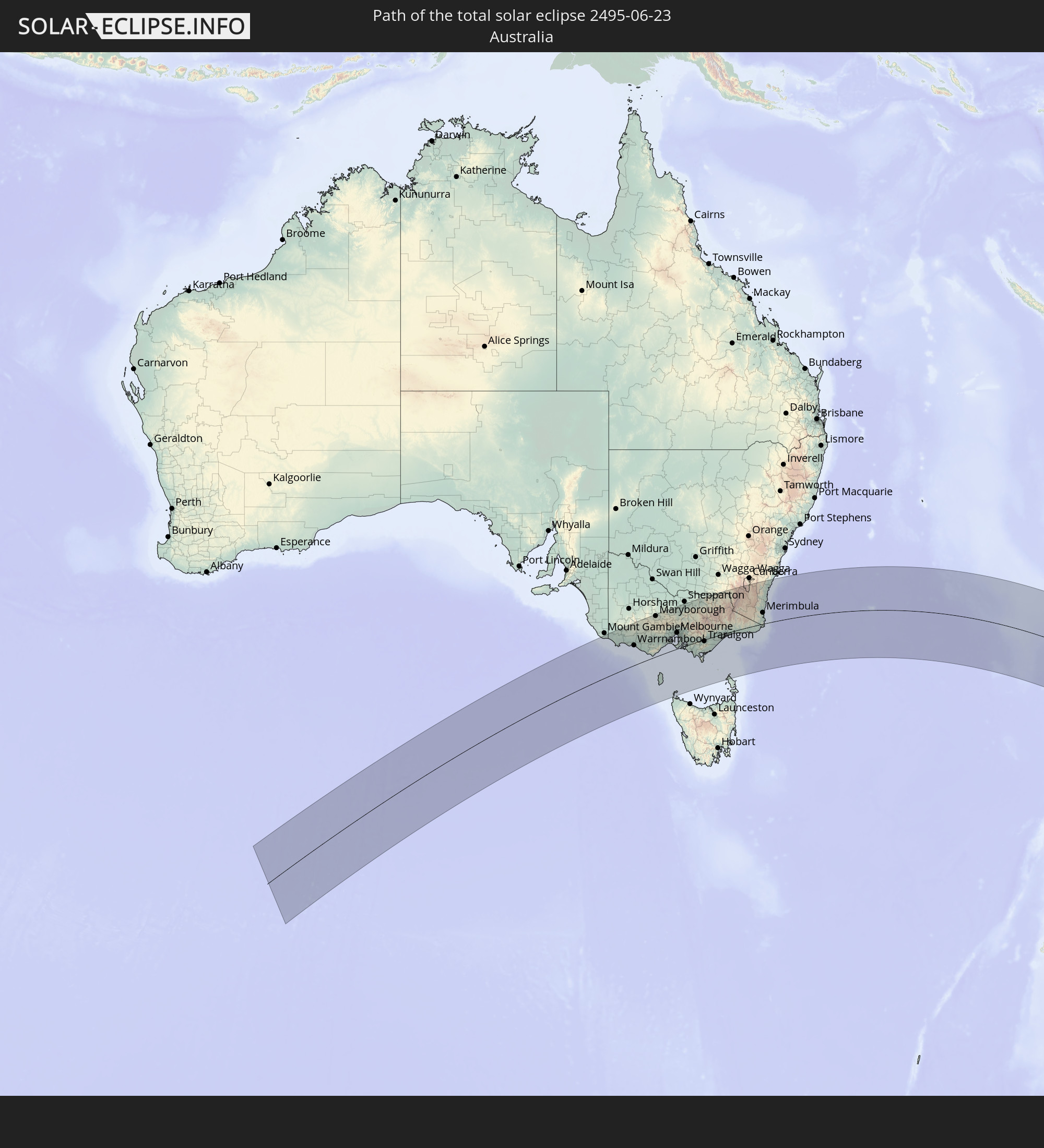 Australien
In den folgenden Ländern ist die Sonnenfinsternis partiell zu sehen


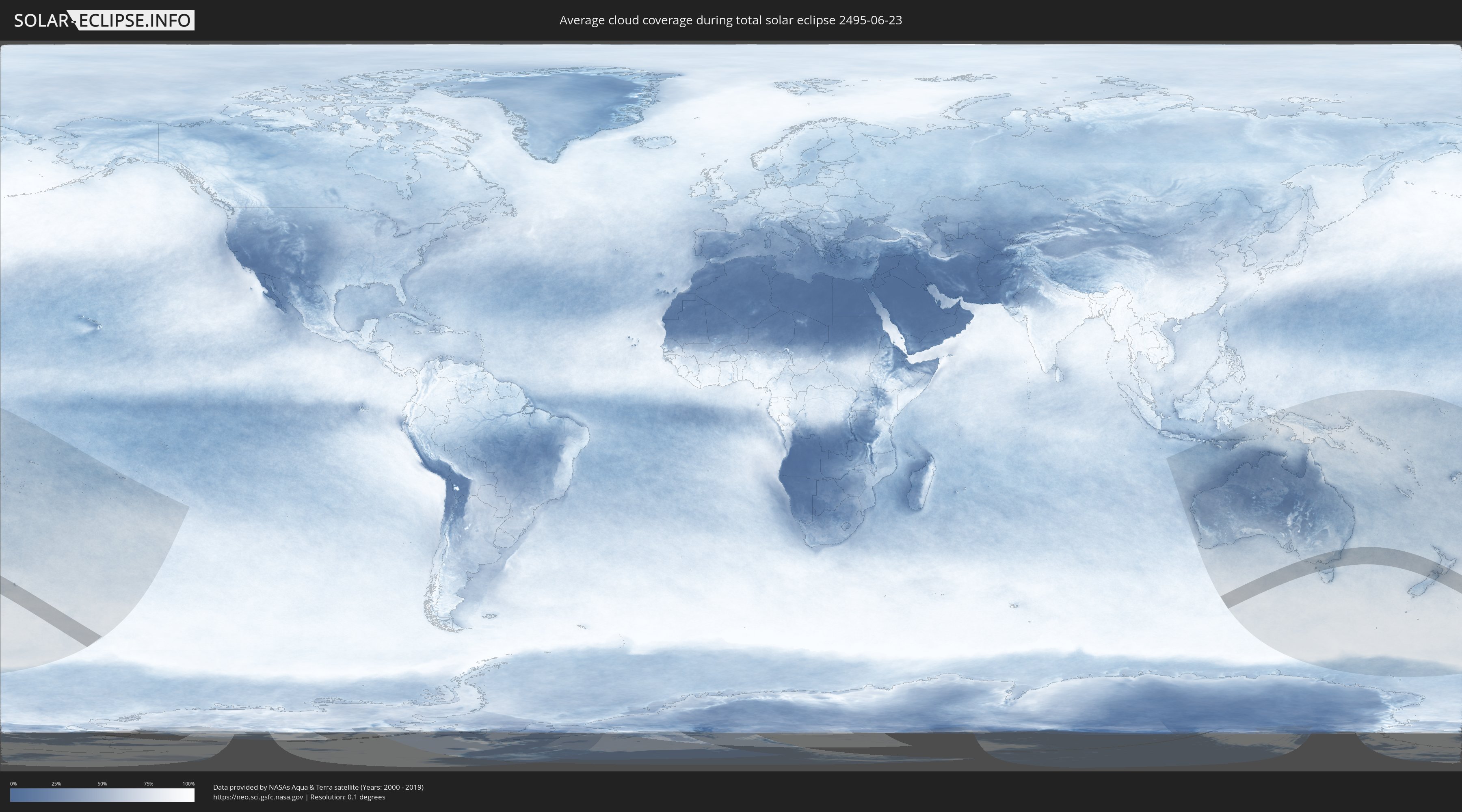
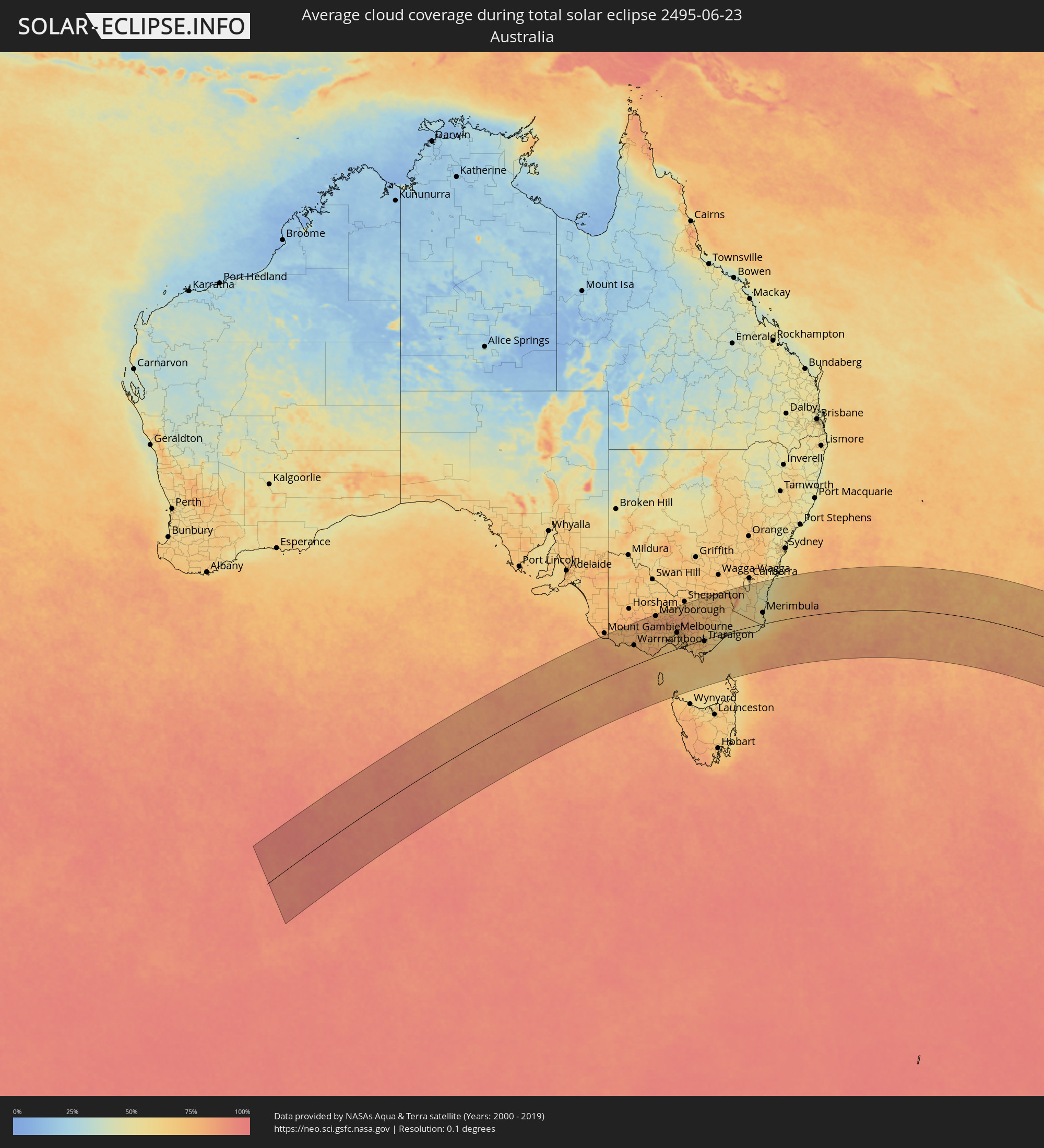
Wie wird das Wetter während der totalen Sonnenfinsternis am 23.06.2495?
Wo ist der beste Ort, um die totale Sonnenfinsternis vom 23.06.2495 zu beobachten?
Die folgenden Karten zeigen die durchschnittliche Bewölkung für den Tag, an dem die totale Sonnenfinsternis
stattfindet. Mit Hilfe der Karten lässt sich der Ort entlang des Finsternispfades eingrenzen,
der die besten Aussichen auf einen klaren wolkenfreien Himmel bietet.
Trotzdem muss man immer lokale Gegenenheiten beachten und sollte sich genau über das Wetter an seinem
gewählten Beobachtungsort informieren.
Die Daten stammen von den beiden NASA-Satelliten
AQUA und TERRA
und wurden über einen Zeitraum von 19 Jahren (2000 - 2019) gemittelt.

Detaillierte Länderkarten
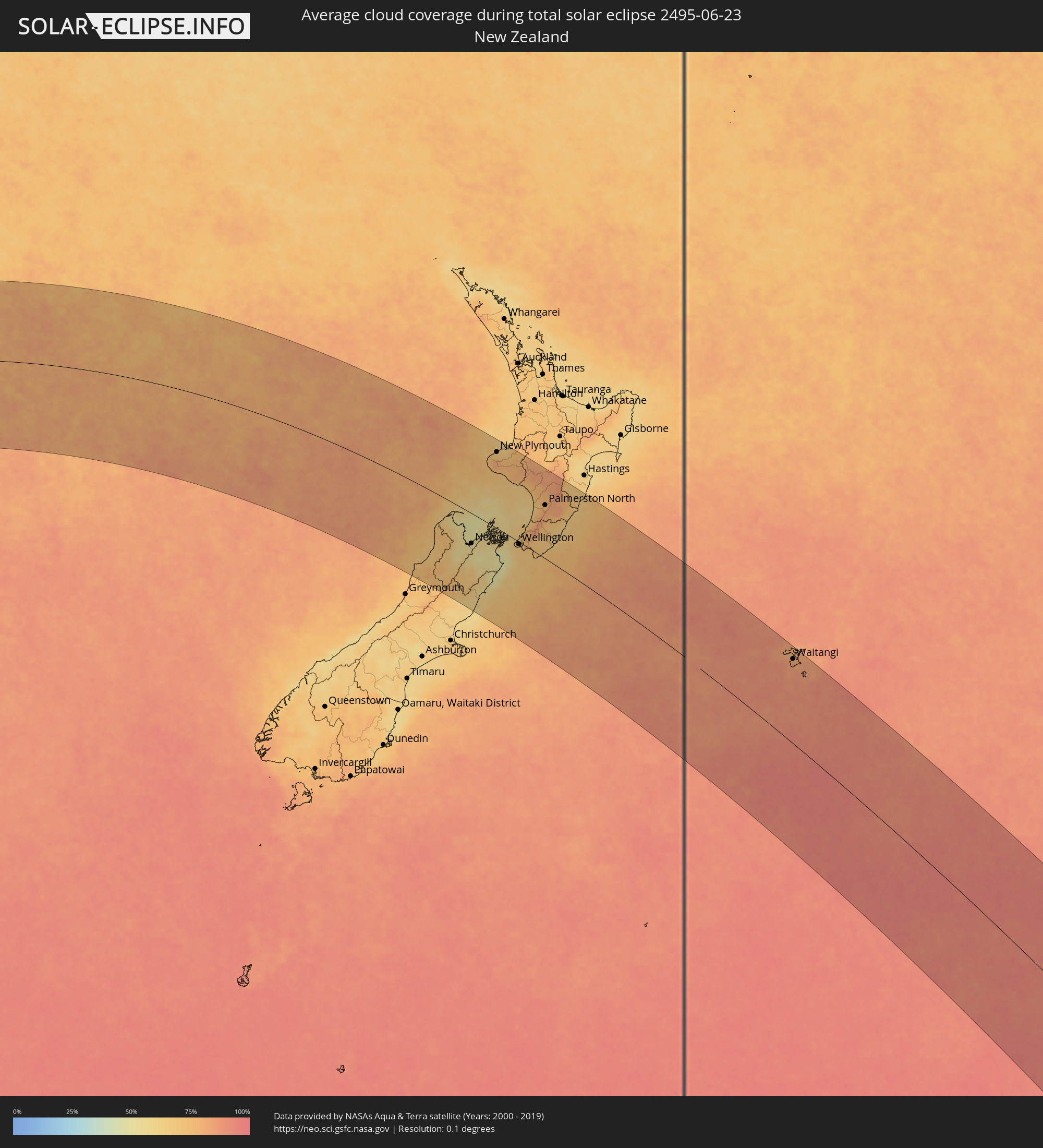 Neuseeland
 Australien
Orte im Finsternispfad
Die nachfolgene Tabelle zeigt Städte und Orte mit mehr als 5.000 Einwohnern, die sich im Finsternispfad befinden. Städte mit mehr als 100.000 Einwohnern sind dick gekennzeichnet. Mit einem Klick auf den Ort öffnet sich eine Detailkarte die die Lage des jeweiligen Ortes zusammen mit dem Verlauf der zentralen Finsternis präsentiert.
| Ort | Typ | Dauer der Verfinsterung | Ortszeit bei maximaler Verfinsterung | Entfernung zur Zentrallinie | Ø Bewölkung |
 Waitangi, Chatham Islands
|
total | - | 15:08:56 UTC+13:45 | 164 km | 84% |
 Portland, Victoria
|
total | - | 11:04:08 UTC+11:00 | 125 km | 73% |
|
Hamilton, Victoria
|
total | - | 11:04:12 UTC+11:00 | 173 km | 76% |
|
Warrnambool, Victoria
|
total | - | 11:05:34 UTC+11:00 | 92 km | 75% |
|
Ararat, Victoria
|
total | - | 11:05:12 UTC+11:00 | 192 km | 80% |
|
Colac, Victoria
|
total | - | 11:07:18 UTC+11:00 | 62 km | 79% |
|
Maryborough, Victoria
|
total | - | 11:06:19 UTC+11:00 | 193 km | 77% |
|
Sebastopol, Victoria
|
total | - | 11:07:00 UTC+11:00 | 133 km | 79% |
|
Ballarat, Victoria
|
total | - | 11:07:00 UTC+11:00 | 135 km | 79% |
|
Castlemaine, Victoria
|
total | - | 11:07:08 UTC+11:00 | 176 km | 82% |
|
Kangaroo Flat, Victoria
|
total | - | 11:06:57 UTC+11:00 | 203 km | 73% |
|
Hamlyn Heights, Victoria
|
total | - | 11:08:19 UTC+11:00 | 62 km | 74% |
|
Geelong, Victoria
|
total | - | 11:08:24 UTC+11:00 | 59 km | 72% |
|
Leopold, Victoria
|
total | - | 11:08:37 UTC+11:00 | 51 km | 67% |
|
Clifton Springs, Victoria
|
total | - | 11:08:44 UTC+11:00 | 52 km | 68% |
|
Melton South, Victoria
|
total | - | 11:08:21 UTC+11:00 | 98 km | 74% |
|
Melton, Victoria
|
total | - | 11:08:20 UTC+11:00 | 101 km | 74% |
|
Kurunjang, Victoria
|
total | - | 11:08:21 UTC+11:00 | 101 km | 74% |
|
Hoppers Crossing, Victoria
|
total | - | 11:08:43 UTC+11:00 | 76 km | 70% |
|
Sunbury, Victoria
|
total | - | 11:08:29 UTC+11:00 | 108 km | 75% |
|
Derrimut, Victoria
|
total | - | 11:08:45 UTC+11:00 | 84 km | 71% |
|
Delahey, Victoria
|
total | - | 11:08:42 UTC+11:00 | 91 km | 73% |
|
Cairnlea, Victoria
|
total | - | 11:08:45 UTC+11:00 | 87 km | 71% |
|
Saint Albans, Victoria
|
total | - | 11:08:45 UTC+11:00 | 89 km | 73% |
|
Rye, Victoria
|
total | - | 11:09:23 UTC+11:00 | 22 km | 69% |
|
Braybrook, Victoria
|
total | - | 11:08:54 UTC+11:00 | 82 km | 72% |
|
Maidstone, Victoria
|
total | - | 11:08:55 UTC+11:00 | 82 km | 72% |
|
Tullamarine, Victoria
|
total | - | 11:08:52 UTC+11:00 | 90 km | 75% |
|
Airport West, Victoria
|
total | - | 11:08:53 UTC+11:00 | 88 km | 75% |
|
Gladstone Park, Victoria
|
total | - | 11:08:51 UTC+11:00 | 92 km | 75% |
|
Flemington, Victoria
|
total | - | 11:09:01 UTC+11:00 | 80 km | 72% |
|
Parkville, Victoria
|
total | - | 11:09:03 UTC+11:00 | 80 km | 73% |
|
Coburg North, Victoria
|
total | - | 11:09:01 UTC+11:00 | 85 km | 76% |
|
Melbourne, Victoria
|
total | - | 11:09:06 UTC+11:00 | 76 km | 73% |
|
South Melbourne, Victoria
|
total | - | 11:09:08 UTC+11:00 | 74 km | 73% |
|
Carlton North, Victoria
|
total | - | 11:09:05 UTC+11:00 | 79 km | 73% |
|
Brunswick East, Victoria
|
total | - | 11:09:05 UTC+11:00 | 80 km | 73% |
|
Windsor, Victoria
|
total | - | 11:09:12 UTC+11:00 | 71 km | 70% |
|
Albert Park, Victoria
|
total | - | 11:09:11 UTC+11:00 | 73 km | 73% |
|
Mount Martha, Victoria
|
total | - | 11:09:37 UTC+11:00 | 27 km | 72% |
|
Fairfield, Victoria
|
total | - | 11:09:10 UTC+11:00 | 78 km | 73% |
|
Ormond, Victoria
|
total | - | 11:09:18 UTC+11:00 | 65 km | 70% |
|
Epping, Victoria
|
total | - | 11:09:04 UTC+11:00 | 91 km | 76% |
|
Cheltenham, Victoria
|
total | - | 11:09:24 UTC+11:00 | 57 km | 70% |
|
Kew East, Victoria
|
total | - | 11:09:15 UTC+11:00 | 75 km | 74% |
|
Heidelberg Heights, Victoria
|
total | - | 11:09:12 UTC+11:00 | 81 km | 77% |
|
Murrumbeena, Victoria
|
total | - | 11:09:22 UTC+11:00 | 64 km | 72% |
|
Rosanna, Victoria
|
total | - | 11:09:13 UTC+11:00 | 80 km | 74% |
|
Ashburton, Victoria
|
total | - | 11:09:22 UTC+11:00 | 67 km | 72% |
|
Mordialloc, Victoria
|
total | - | 11:09:29 UTC+11:00 | 53 km | 69% |
|
Hughesdale, Victoria
|
total | - | 11:09:23 UTC+11:00 | 64 km | 72% |
|
Canterbury, Victoria
|
total | - | 11:09:19 UTC+11:00 | 71 km | 74% |
|
Viewbank, Victoria
|
total | - | 11:09:16 UTC+11:00 | 80 km | 77% |
|
Mernda, Victoria
|
total | - | 11:09:08 UTC+11:00 | 95 km | 78% |
|
Aspendale, Victoria
|
total | - | 11:09:33 UTC+11:00 | 49 km | 69% |
|
Montmorency, Victoria
|
total | - | 11:09:17 UTC+11:00 | 82 km | 77% |
|
Clarinda, Victoria
|
total | - | 11:09:29 UTC+11:00 | 59 km | 72% |
|
Chelsea, Victoria
|
total | - | 11:09:35 UTC+11:00 | 47 km | 69% |
|
Aspendale Gardens, Victoria
|
total | - | 11:09:34 UTC+11:00 | 50 km | 69% |
|
Box Hill South, Victoria
|
total | - | 11:09:24 UTC+11:00 | 70 km | 74% |
|
Frankston, Victoria
|
total | - | 11:09:41 UTC+11:00 | 37 km | 69% |
|
Box Hill, Victoria
|
total | - | 11:09:23 UTC+11:00 | 71 km | 74% |
|
Patterson Lakes, Victoria
|
total | - | 11:09:39 UTC+11:00 | 44 km | 69% |
|
Doncaster East, Victoria
|
total | - | 11:09:24 UTC+11:00 | 74 km | 74% |
|
Eltham North, Victoria
|
total | - | 11:09:19 UTC+11:00 | 83 km | 77% |
|
Blackburn North, Victoria
|
total | - | 11:09:25 UTC+11:00 | 71 km | 75% |
|
Somerville, Victoria
|
total | - | 11:09:50 UTC+11:00 | 28 km | 68% |
|
Hastings, Victoria
|
total | - | 11:09:56 UTC+11:00 | 19 km | 69% |
|
Noble Park North, Victoria
|
total | - | 11:09:37 UTC+11:00 | 55 km | 74% |
|
Skye, Victoria
|
total | - | 11:09:49 UTC+11:00 | 38 km | 68% |
|
Phillip Island, Victoria
|
total | - | 11:10:11 UTC+11:00 | 2 km | 69% |
|
Rowville, Victoria
|
total | - | 11:09:41 UTC+11:00 | 56 km | 74% |
|
Doveton, Victoria
|
total | - | 11:09:45 UTC+11:00 | 49 km | 73% |
|
Knoxfield, Victoria
|
total | - | 11:09:40 UTC+11:00 | 60 km | 74% |
|
Lynbrook, Victoria
|
total | - | 11:09:50 UTC+11:00 | 42 km | 69% |
|
Cranbourne West, Victoria
|
total | - | 11:09:53 UTC+11:00 | 38 km | 69% |
|
Cranbourne East, Victoria
|
total | - | 11:09:58 UTC+11:00 | 35 km | 69% |
|
Bayswater North, Victoria
|
total | - | 11:09:41 UTC+11:00 | 65 km | 77% |
|
Lysterfield, Victoria
|
total | - | 11:09:48 UTC+11:00 | 54 km | 73% |
|
Croydon North, Victoria
|
total | - | 11:09:39 UTC+11:00 | 70 km | 77% |
|
Narre Warren North, Victoria
|
total | - | 11:09:52 UTC+11:00 | 48 km | 73% |
|
Upwey, Victoria
|
total | - | 11:09:49 UTC+11:00 | 56 km | 73% |
|
Lilydale, Victoria
|
total | - | 11:09:43 UTC+11:00 | 72 km | 75% |
|
Montrose, Victoria
|
total | - | 11:09:46 UTC+11:00 | 65 km | 75% |
|
Berwick, Victoria
|
total | - | 11:09:58 UTC+11:00 | 42 km | 72% |
|
Pakenham South, Victoria
|
total | - | 11:10:21 UTC+11:00 | 27 km | 71% |
|
Healesville, Victoria
|
total | - | 11:09:55 UTC+11:00 | 77 km | 77% |
|
North Wonthaggi, Victoria
|
total | - | 11:10:56 UTC+11:00 | 25 km | 68% |
|
Warragul, Victoria
|
total | - | 11:11:06 UTC+11:00 | 13 km | 74% |
|
Benalla, Victoria
|
total | - | 11:09:44 UTC+11:00 | 182 km | 70% |
|
Moe, Victoria
|
total | - | 11:11:41 UTC+11:00 | 2 km | 73% |
|
Wangaratta, Victoria
|
total | - | 11:10:09 UTC+11:00 | 194 km | 72% |
|
Traralgon, Victoria
|
total | - | 11:12:12 UTC+11:00 | 8 km | 71% |
|
Albury, New South Wales
|
total | - | 11:11:00 UTC+11:00 | 209 km | 72% |
|
East Albury, New South Wales
|
total | - | 11:11:01 UTC+11:00 | 208 km | 72% |
|
Sale, Victoria
|
total | - | 11:13:03 UTC+11:00 | 12 km | 63% |
|
Bairnsdale, Victoria
|
total | - | 11:13:47 UTC+11:00 | 5 km | 61% |
|
Cooma, New South Wales
|
total | - | 11:15:15 UTC+11:00 | 142 km | 63% |
|
Merimbula, New South Wales
|
total | - | 11:17:17 UTC+11:00 | 56 km | 51% |
|
Batemans Bay, New South Wales
|
total | - | 11:16:51 UTC+11:00 | 180 km | 49% |
|
Ulladulla, New South Wales
|
total | - | 11:17:10 UTC+11:00 | 213 km | 52% |
|
Port Motueka, Tasman
|
total | - | 14:06:29 UTC+13:00 | 67 km | 56% |
|
Richmond, Tasman
|
total | - | 14:06:48 UTC+13:00 | 79 km | 55% |
|
Nelson, Nelson
|
total | - | 14:07:00 UTC+13:00 | 69 km | 55% |
|
Blenheim, Marlborough
|
total | - | 14:08:15 UTC+13:00 | 63 km | 53% |
|
New Plymouth, Taranaki
|
total | - | 14:08:38 UTC+13:00 | 178 km | 71% |
|
Waitara, Taranaki
|
total | - | 14:08:57 UTC+13:00 | 191 km | 67% |
|
Hawera, Taranaki
|
total | - | 14:09:00 UTC+13:00 | 135 km | 69% |
|
Wellington, Wellington
|
total | - | 14:09:49 UTC+13:00 | 5 km | 68% |
|
Porirua, Wellington
|
total | - | 14:09:59 UTC+13:00 | 13 km | 70% |
|
Petone, Wellington
|
total | - | 14:10:00 UTC+13:00 | 4 km | 71% |
|
Lower Hutt, Wellington
|
total | - | 14:10:06 UTC+13:00 | 8 km | 71% |
|
Paraparaumu, Wellington
|
total | - | 14:10:19 UTC+13:00 | 40 km | 73% |
|
Wanganui, Manawatu-Wanganui
|
total | - | 14:10:28 UTC+13:00 | 136 km | 71% |
|
Upper Hutt, Wellington
|
total | - | 14:10:21 UTC+13:00 | 21 km | 77% |
|
Otaki, Wellington
|
total | - | 14:10:35 UTC+13:00 | 61 km | 79% |
|
Levin, Manawatu-Wanganui
|
total | - | 14:10:50 UTC+13:00 | 79 km | 76% |
|
Palmerston North, Manawatu-Wanganui
|
total | - | 14:11:30 UTC+13:00 | 120 km | 81% |
|
Masterton, Wellington
|
total | - | 14:11:31 UTC+13:00 | 65 km | 69% |