Totale Sonnenfinsternis vom 10.10.2656
| Wochentag: | Freitag |
| Maximale Dauer der Verfinsterung: | 04m28s |
| Maximale Breite des Finsternispfades: | 197 km |
| Saroszyklus: | 154 |
| Bedeckungsgrad: | 100% |
| Magnitude: | 1.0539 |
| Gamma: | 0.4468 |
Wo kann man die Sonnenfinsternis vom 10.10.2656 sehen?
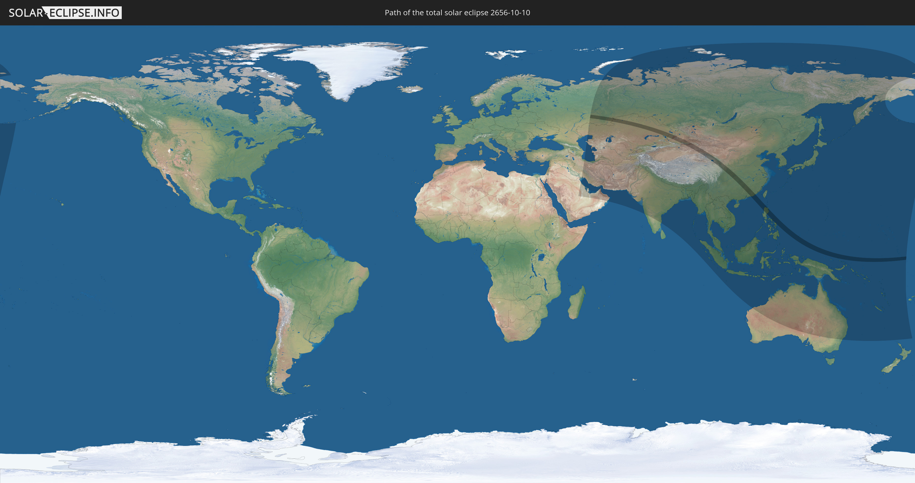
Die Sonnenfinsternis am 10.10.2656 kann man in 56 Ländern als partielle Sonnenfinsternis beobachten.
Der Finsternispfad verläuft durch 7 Länder. Nur in diesen Ländern ist sie als totale Sonnenfinsternis zu sehen.
In den folgenden Ländern ist die Sonnenfinsternis total zu sehen
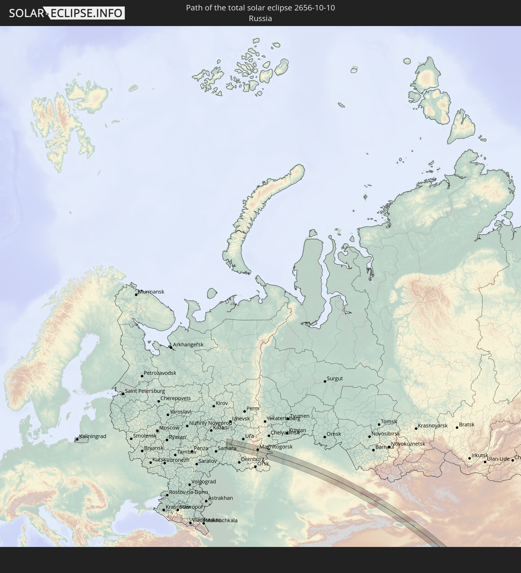 Russland
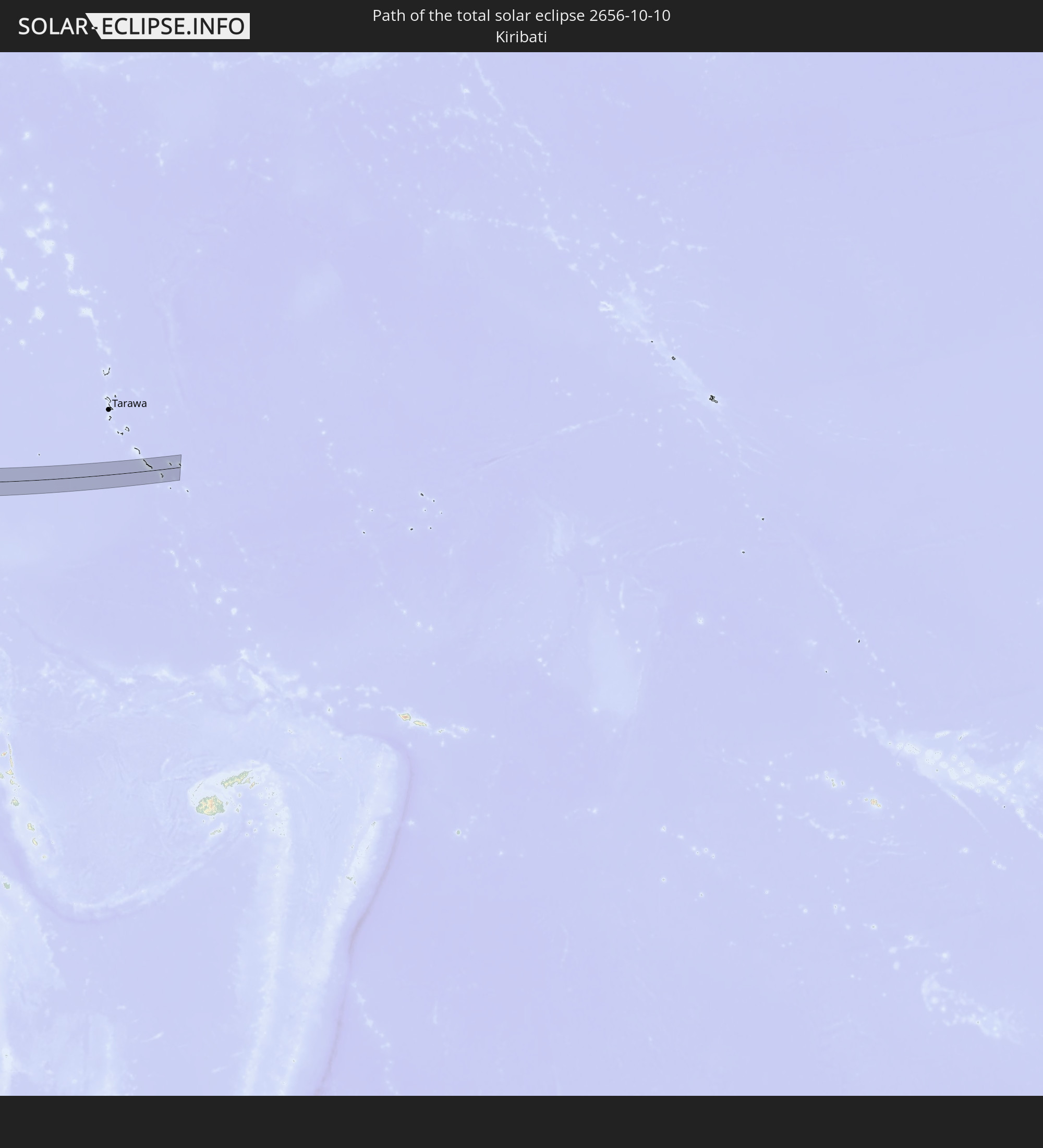 Kiribati
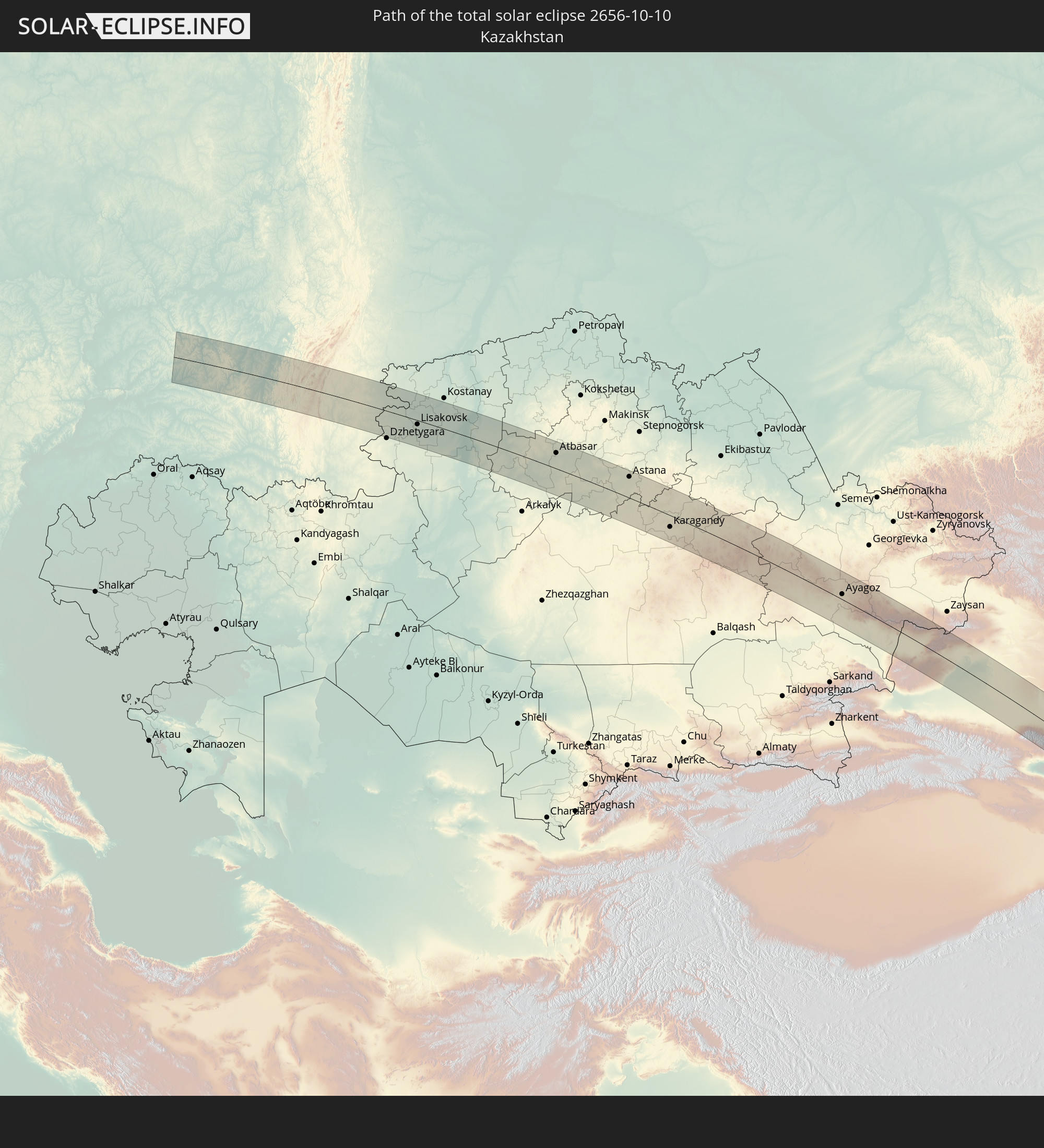 Kasachstan
 Volksrepublik China
 Philippinen
 Palau
Palau
 Papua-Neuguinea
In den folgenden Ländern ist die Sonnenfinsternis partiell zu sehen
 Russland
 Vereinigte Staaten
 United States Minor Outlying Islands
 Kiribati
 Saudi-Arabien
 Iran
Iran
 Aserbaidschan
 Kasachstan
 Kuwait
 Bahrain
 Katar
Katar
 Vereinigte Arabische Emirate
 Oman
Oman
 Turkmenistan
 Usbekistan
 Afghanistan
 Pakistan
 Tadschikistan
 Indien
 Kirgisistan
 Volksrepublik China
 Nepal
Nepal
 Mongolei
 Bangladesch
 Bhutan
 Myanmar
 Indonesien
 Thailand
 Malaysia
 Laos
Laos
 Vietnam
 Kambodscha
 Singapur
 Weihnachtsinsel
 Australien
 Macau
Macau
 Hongkong
 Brunei
 Taiwan
 Philippinen
 Japan
Japan
 Osttimor
 Nordkorea
 Südkorea
 Palau
Palau
 Föderierte Staaten von Mikronesien
 Papua-Neuguinea
 Guam
Guam
 Nördliche Marianen
 Salomonen
 Neukaledonien
 Marshallinseln
 Vanuatu
 Nauru
Nauru
 Norfolkinsel
 Tuvalu
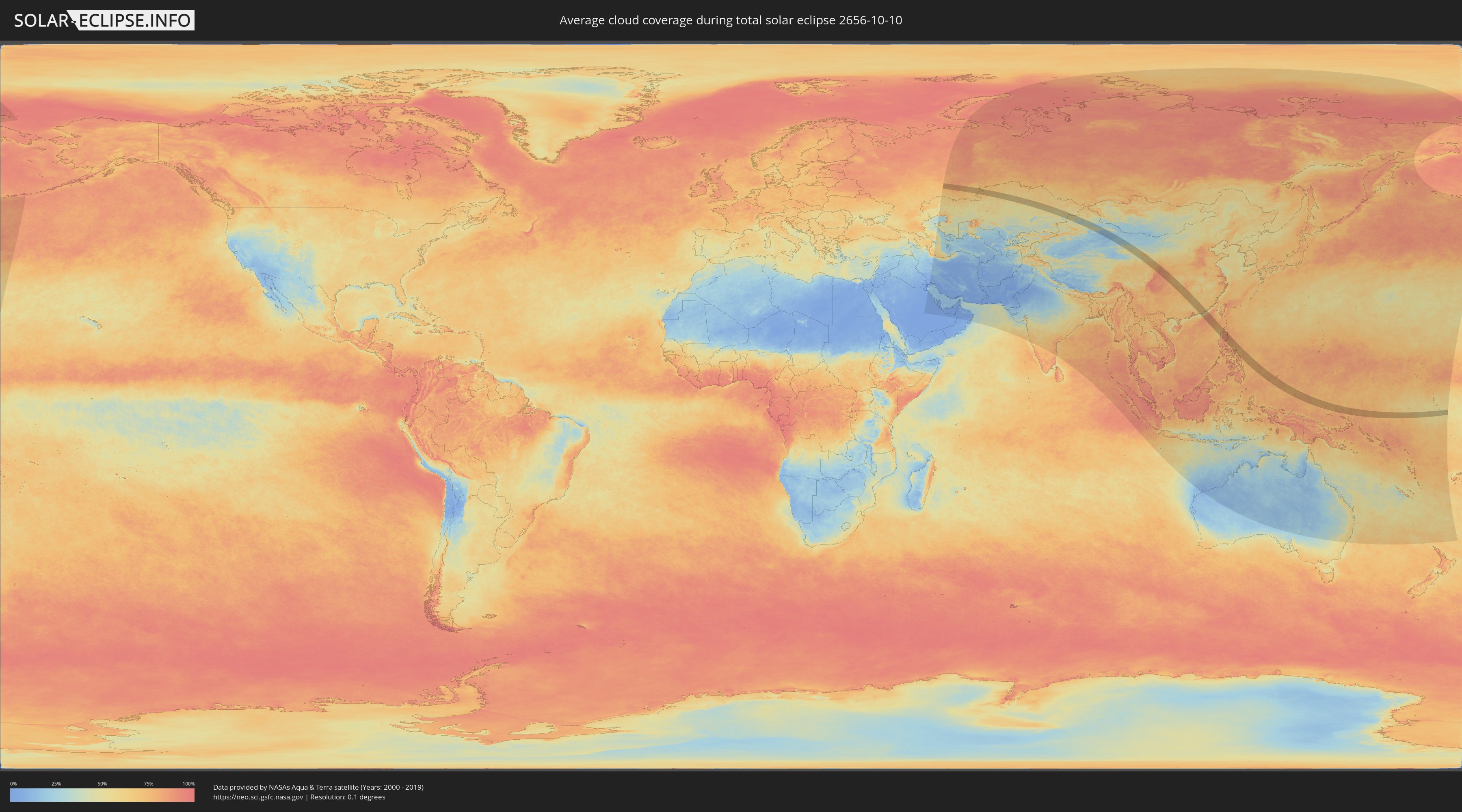
Wie wird das Wetter während der totalen Sonnenfinsternis am 10.10.2656?
Wo ist der beste Ort, um die totale Sonnenfinsternis vom 10.10.2656 zu beobachten?
Die folgenden Karten zeigen die durchschnittliche Bewölkung für den Tag, an dem die totale Sonnenfinsternis
stattfindet. Mit Hilfe der Karten lässt sich der Ort entlang des Finsternispfades eingrenzen,
der die besten Aussichen auf einen klaren wolkenfreien Himmel bietet.
Trotzdem muss man immer lokale Gegenenheiten beachten und sollte sich genau über das Wetter an seinem
gewählten Beobachtungsort informieren.
Die Daten stammen von den beiden NASA-Satelliten
AQUA und TERRA
und wurden über einen Zeitraum von 19 Jahren (2000 - 2019) gemittelt.

Detaillierte Länderkarten
 Russland
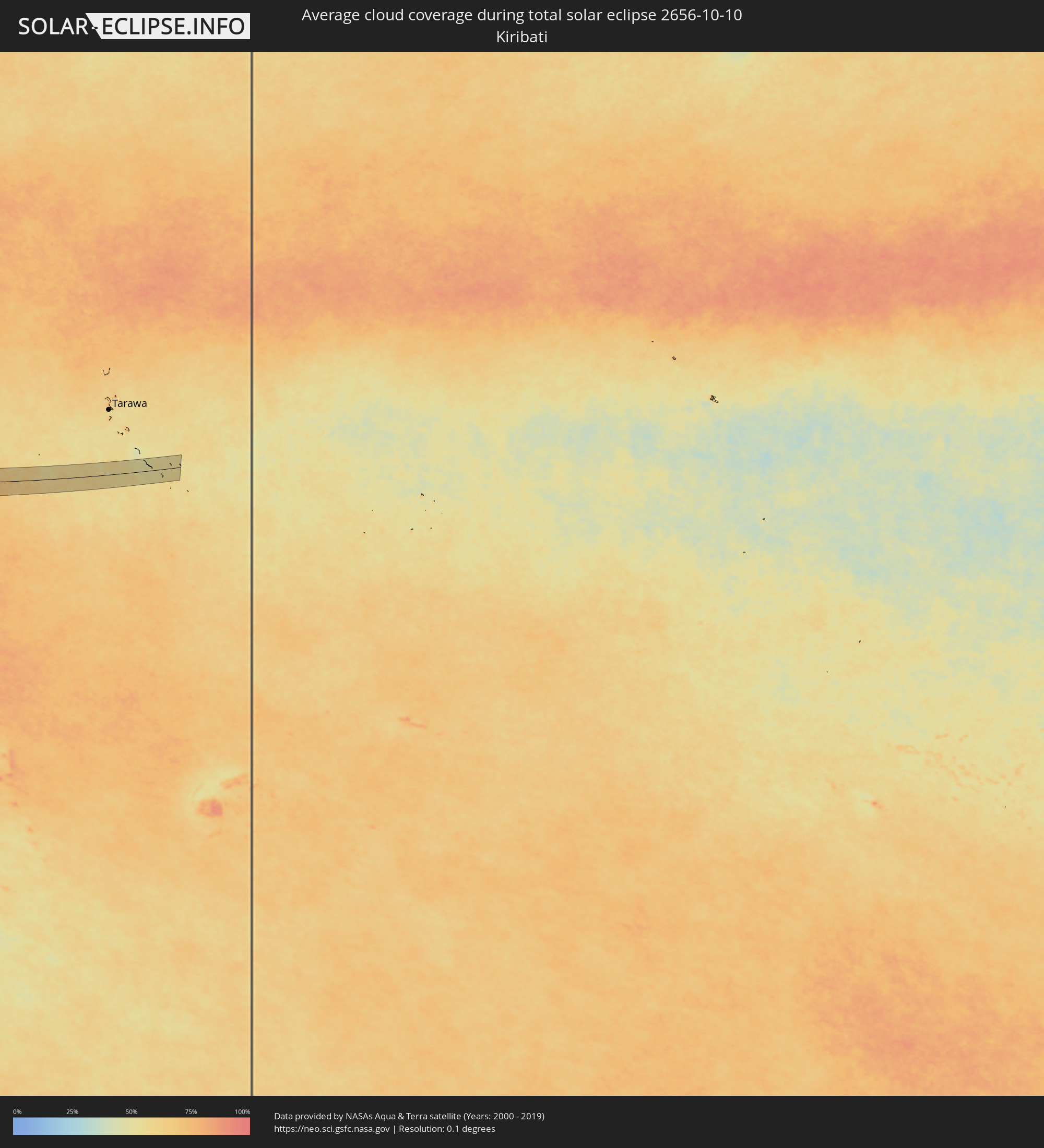 Kiribati
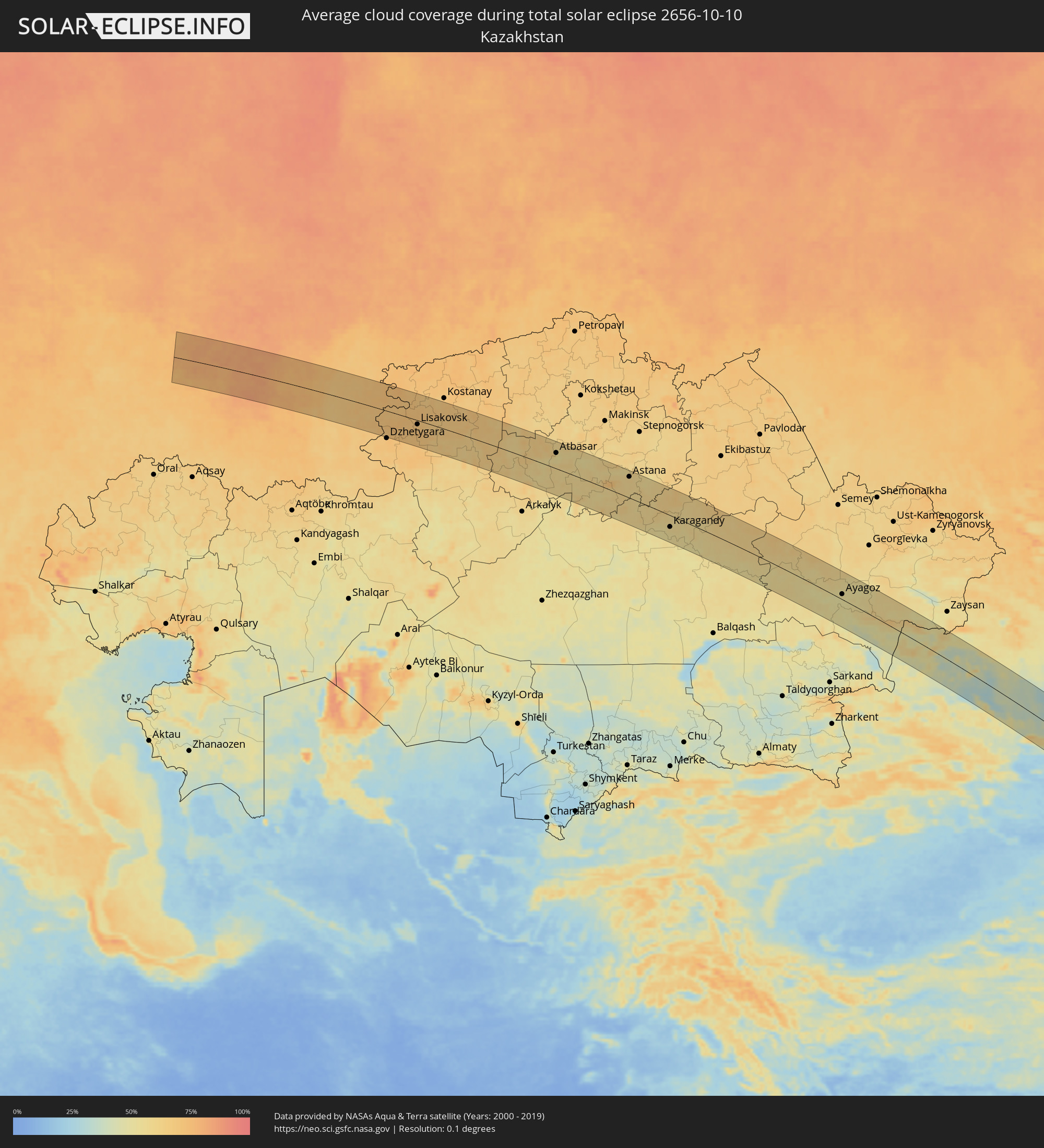 Kasachstan
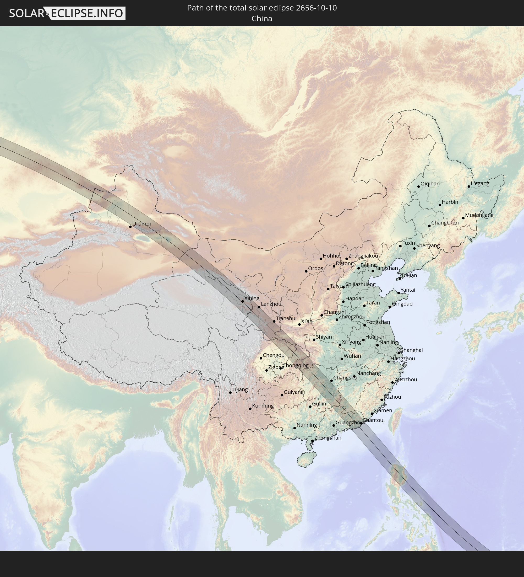
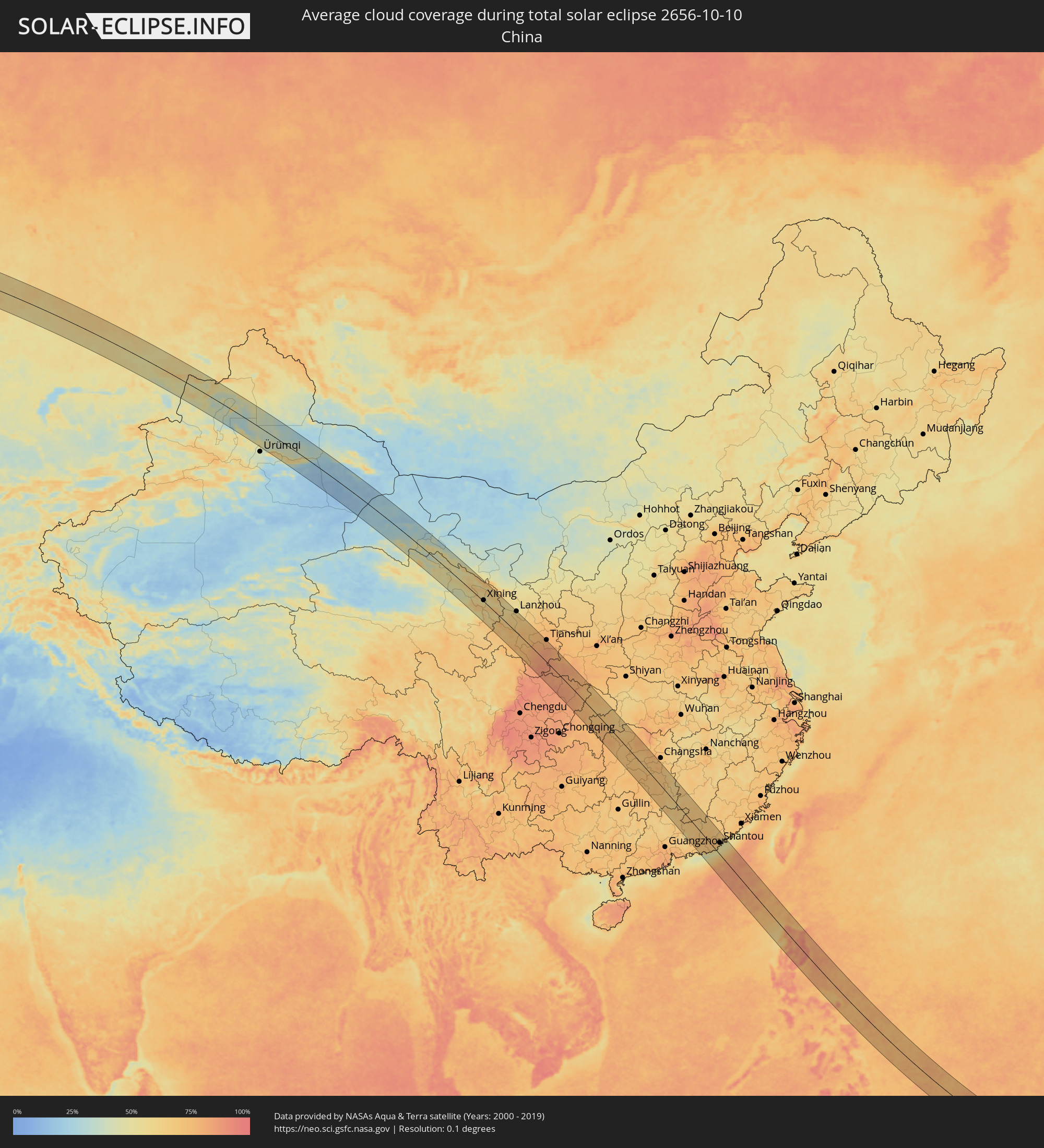 Volksrepublik China
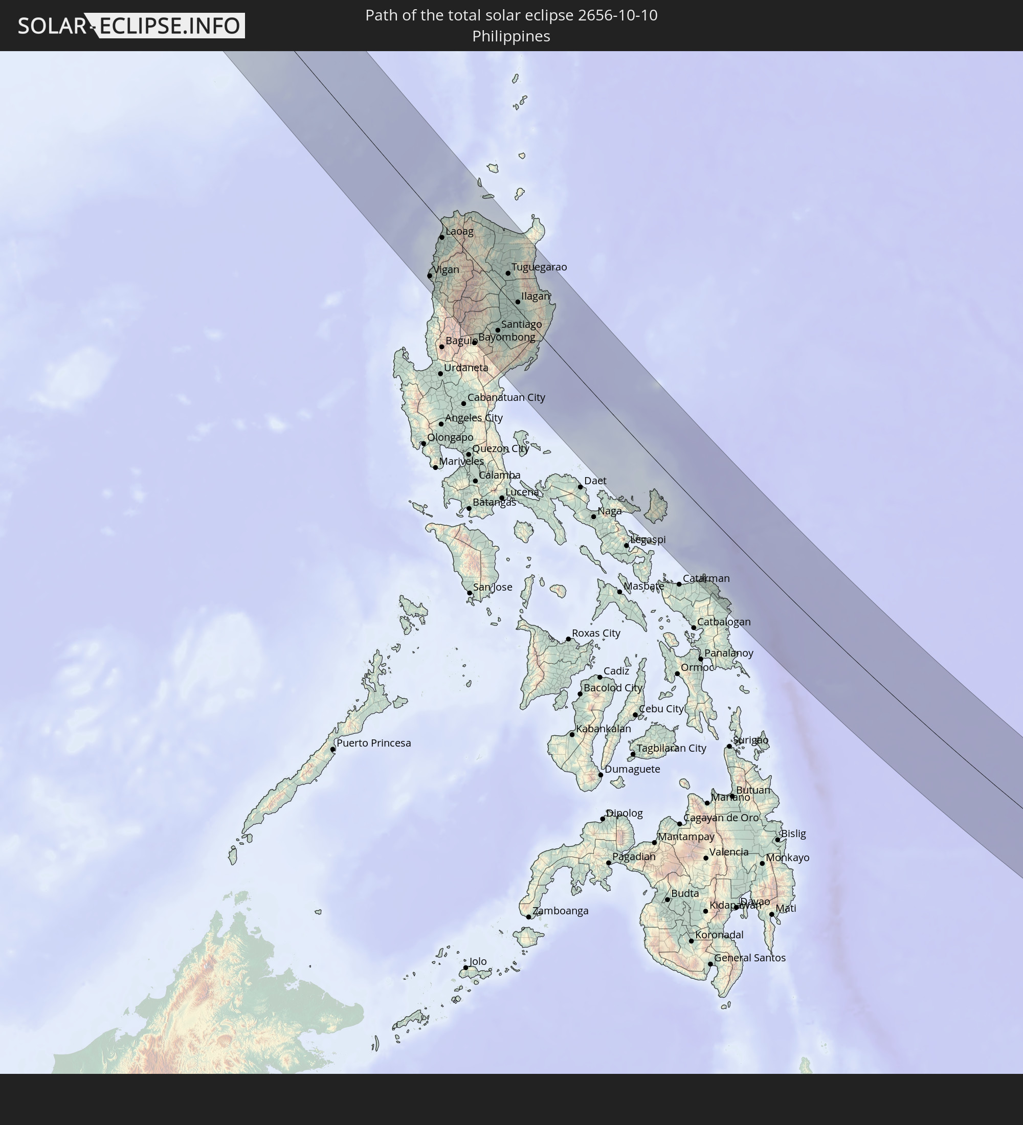
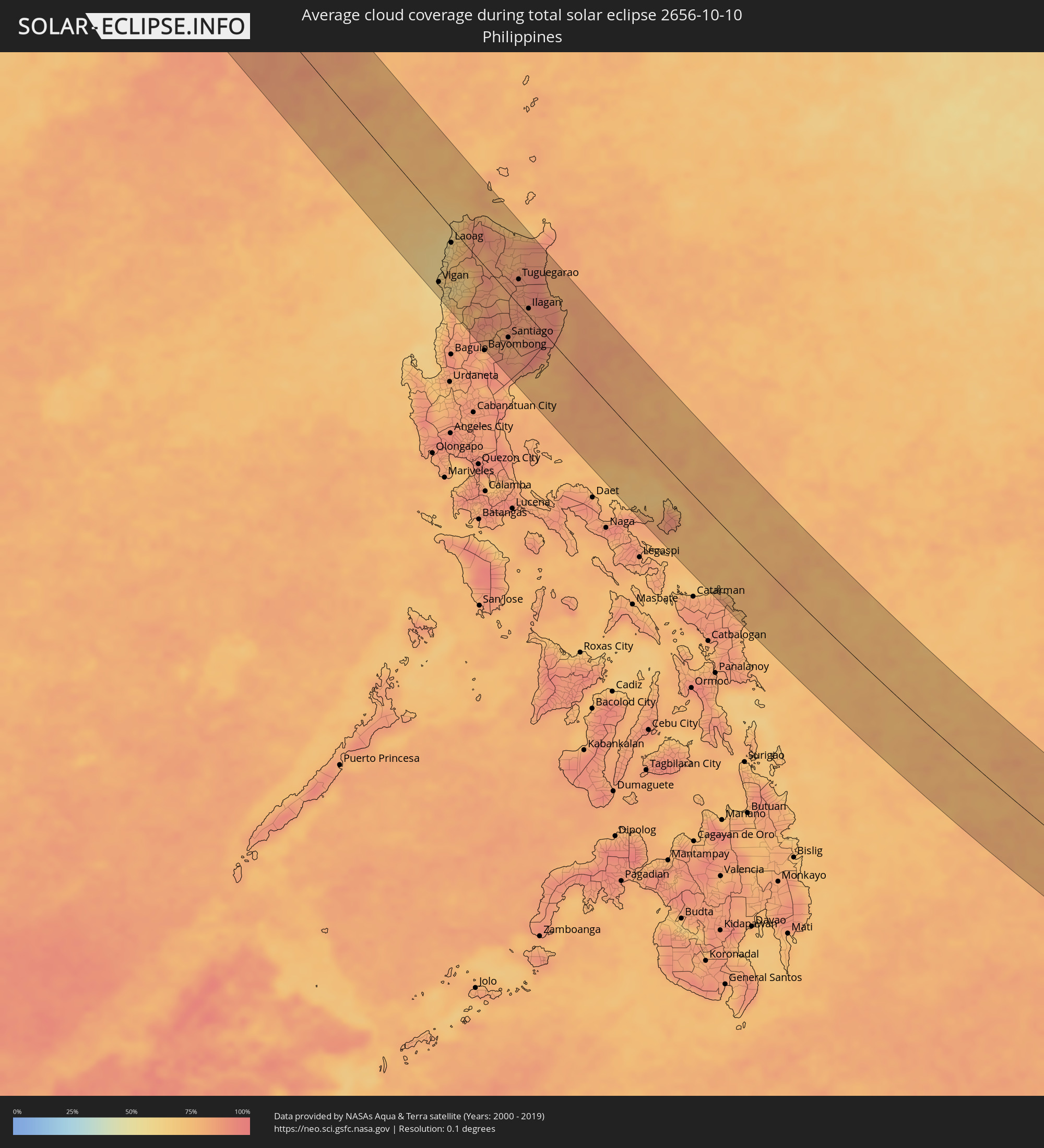 Philippinen
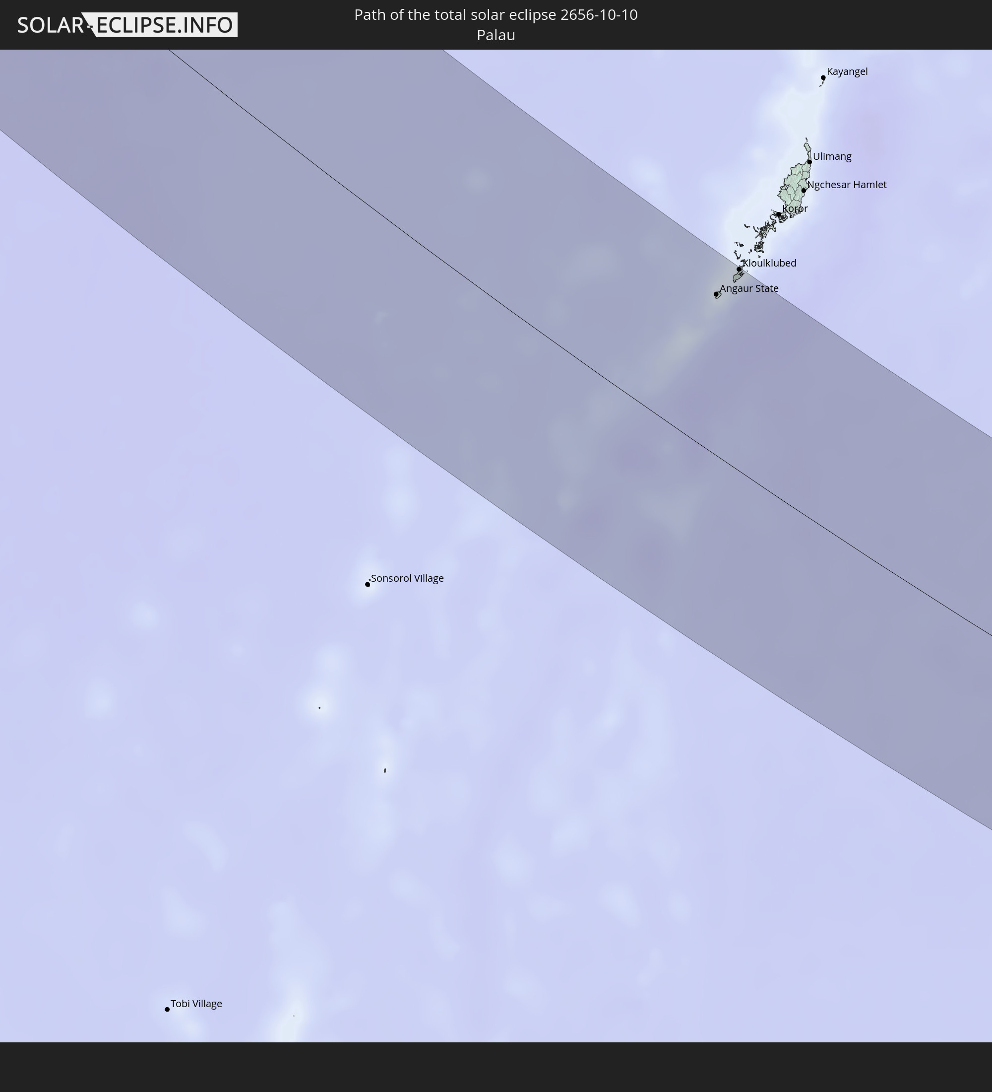
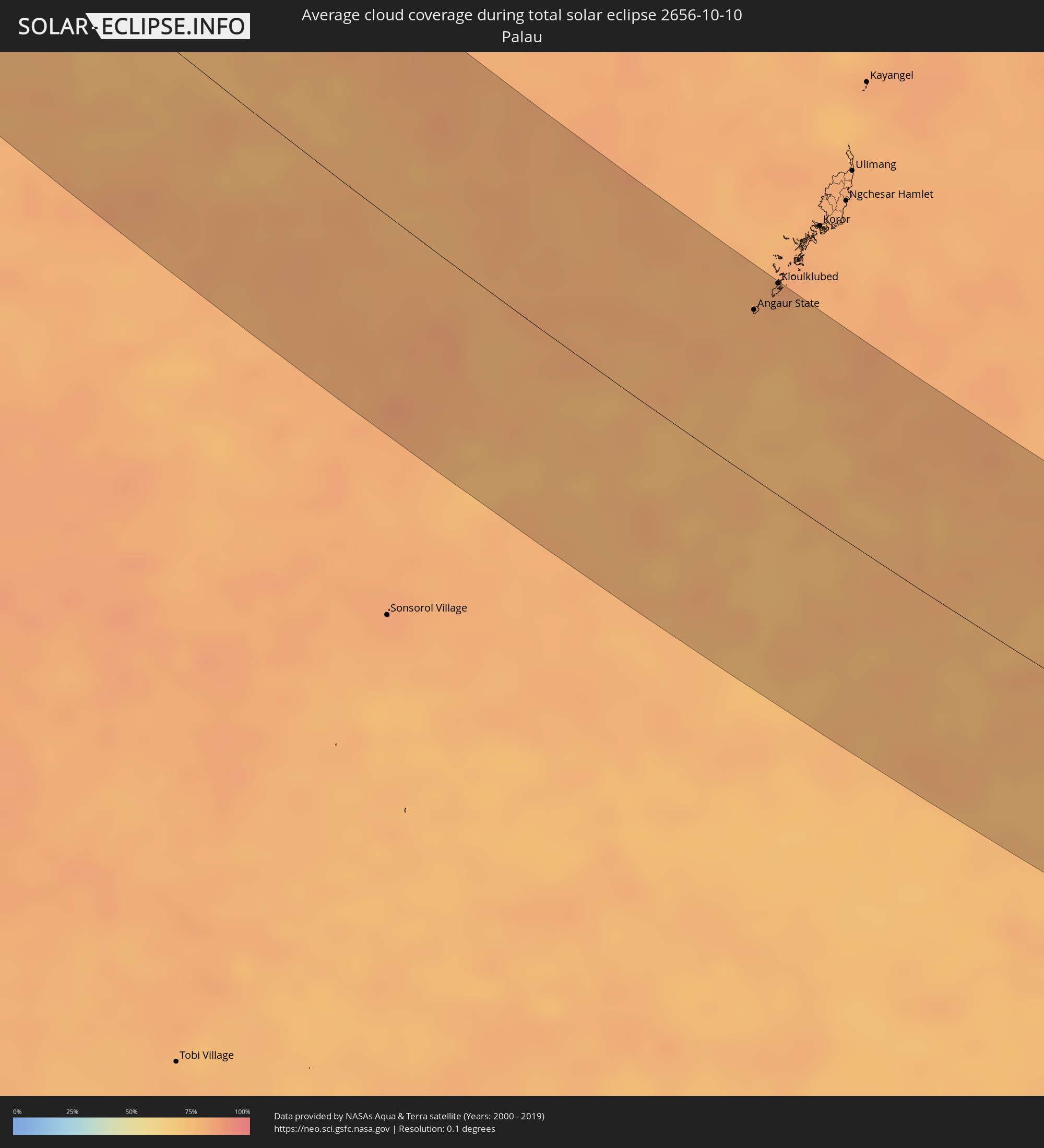 Palau
Palau
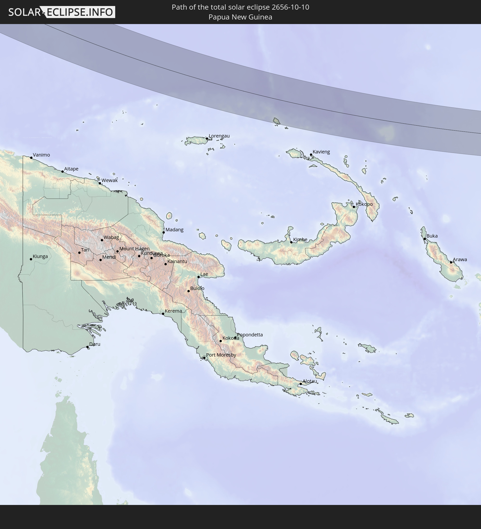
 Papua-Neuguinea
Orte im Finsternispfad
Die nachfolgene Tabelle zeigt Städte und Orte mit mehr als 5.000 Einwohnern, die sich im Finsternispfad befinden. Städte mit mehr als 100.000 Einwohnern sind dick gekennzeichnet. Mit einem Klick auf den Ort öffnet sich eine Detailkarte die die Lage des jeweiligen Ortes zusammen mit dem Verlauf der zentralen Finsternis präsentiert.
| Ort | Typ | Dauer der Verfinsterung | Ortszeit bei maximaler Verfinsterung | Entfernung zur Zentrallinie | Ø Bewölkung |
|
Pokhvistnevo, Samara
|
total | - | 06:56:01 UTC+04:00 | 65 km | 72% |
|
Buguruslan, Orenburg
|
total | - | 07:56:03 UTC+05:00 | 61 km | 74% |
|
Leninogorsk, Tatarstan
|
total | - | 05:56:44 UTC+03:00 | 43 km | 77% |
|
Karabash, Tatarstan
|
total | - | 05:56:49 UTC+03:00 | 54 km | 77% |
|
Asekeyevo, Orenburg
|
total | - | 07:56:01 UTC+05:00 | 65 km | 76% |
|
Bugul’ma, Tatarstan
|
total | - | 05:56:43 UTC+03:00 | 40 km | 78% |
|
Bavly, Tatarstan
|
total | - | 05:56:40 UTC+03:00 | 31 km | 79% |
|
Urussu, Tatarstan
|
total | - | 05:56:50 UTC+03:00 | 56 km | 81% |
|
Oktyabr’skiy, Bashkortostan
|
total | - | 07:56:45 UTC+05:00 | 43 km | 80% |
|
Abdulino, Orenburg
|
total | - | 07:56:12 UTC+05:00 | 39 km | 76% |
|
Tuymazy, Bashkortostan
|
total | - | 07:56:52 UTC+05:00 | 60 km | 80% |
|
Serafimovskiy, Bashkortostan
|
total | - | 07:56:45 UTC+05:00 | 41 km | 79% |
|
Subkhankulovo, Bashkortostan
|
total | - | 07:56:51 UTC+05:00 | 56 km | 78% |
|
Priyutovo, Bashkortostan
|
total | - | 07:56:23 UTC+05:00 | 14 km | 79% |
|
Kandry, Bashkortostan
|
total | - | 07:56:53 UTC+05:00 | 61 km | 78% |
|
Belebey, Bashkortostan
|
total | - | 07:56:33 UTC+05:00 | 13 km | 77% |
|
Bizhbulyak, Bashkortostan
|
total | - | 07:56:16 UTC+05:00 | 31 km | 76% |
|
Buzdyak, Bashkortostan
|
total | - | 07:56:57 UTC+05:00 | 70 km | 80% |
|
Kirgiz-Miyaki, Bashkortostan
|
total | - | 07:56:18 UTC+05:00 | 30 km | 80% |
|
Rayevskiy, Bashkortostan
|
total | - | 07:56:38 UTC+05:00 | 19 km | 81% |
|
Davlekanovo, Bashkortostan
|
total | - | 07:56:45 UTC+05:00 | 37 km | 81% |
|
Sterlibashevo, Bashkortostan
|
total | - | 07:56:13 UTC+05:00 | 44 km | 83% |
|
Tolbazy, Bashkortostan
|
total | - | 07:56:44 UTC+05:00 | 29 km | 82% |
|
Salavat, Bashkortostan
|
total | - | 07:56:17 UTC+05:00 | 40 km | 80% |
|
Sterlitamak, Bashkortostan
|
total | - | 07:56:27 UTC+05:00 | 13 km | 80% |
|
Ishimbay, Bashkortostan
|
total | - | 07:56:21 UTC+05:00 | 30 km | 82% |
|
Beloretsk, Bashkortostan
|
total | - | 07:57:07 UTC+05:00 | 64 km | 73% |
|
Sibay, Bashkortostan
|
total | - | 07:56:19 UTC+05:00 | 66 km | 66% |
|
Magnitogorsk, Chelyabinsk
|
total | - | 07:56:52 UTC+05:00 | 16 km | 68% |
|
Agapovka, Chelyabinsk
|
total | - | 07:56:48 UTC+05:00 | 5 km | 66% |
|
Verkhneural’sk, Chelyabinsk
|
total | - | 07:57:13 UTC+05:00 | 68 km | 68% |
|
Bredy, Chelyabinsk
|
total | - | 07:56:29 UTC+05:00 | 67 km | 69% |
|
Lokomotivnyy, Chelyabinsk
|
total | - | 07:56:56 UTC+05:00 | 1 km | 70% |
|
Kartaly, Chelyabinsk
|
total | - | 07:56:59 UTC+05:00 | 7 km | 69% |
|
Varna, Chelyabinsk
|
total | - | 07:57:16 UTC+05:00 | 48 km | 71% |
|
Lisakovsk, Qostanay
|
total | - | 07:57:07 UTC+05:00 | 11 km | 69% |
|
Tobol, Qostanay
|
total | - | 07:57:14 UTC+05:00 | 7 km | 68% |
|
Rudnyy, Qostanay
|
total | - | 07:57:33 UTC+05:00 | 47 km | 70% |
|
Qusmuryn, Qostanay
|
total | - | 07:57:41 UTC+05:00 | 23 km | 67% |
|
Esil, Aqmola
|
total | - | 07:57:58 UTC+05:00 | 12 km | 57% |
|
Zhaqsy, Aqmola
|
total | - | 07:58:16 UTC+05:00 | 28 km | 62% |
|
Atbasar, Aqmola
|
total | - | 07:58:36 UTC+05:00 | 43 km | 52% |
|
Astrakhan, Aqmola
|
total | - | 07:59:01 UTC+05:00 | 50 km | 55% |
|
Astana, Astana Qalasy
|
total | - | 07:59:33 UTC+05:00 | 58 km | 61% |
|
Kīevka, Qaraghandy
|
total | - | 07:59:10 UTC+05:00 | 34 km | 57% |
|
Osakarovka, Qaraghandy
|
total | - | 07:59:46 UTC+05:00 | 25 km | 60% |
|
Shakhan, Qaraghandy
|
total | - | 07:59:29 UTC+05:00 | 48 km | 51% |
|
Novodolīnskīy, Qaraghandy
|
total | - | 07:59:28 UTC+05:00 | 58 km | 53% |
|
Sorang, Qaraghandy
|
total | - | 07:59:34 UTC+05:00 | 46 km | 51% |
|
Abay, Qaraghandy
|
total | - | 07:59:31 UTC+05:00 | 61 km | 53% |
|
Aqtas, Qaraghandy
|
total | - | 07:59:37 UTC+05:00 | 43 km | 54% |
|
Temirtau, Qaraghandy
|
total | - | 07:59:44 UTC+05:00 | 15 km | 58% |
|
Aqtaū, Qaraghandy
|
total | - | 07:59:52 UTC+05:00 | 6 km | 57% |
|
Karagandy, Qaraghandy
|
total | - | 07:59:45 UTC+05:00 | 32 km | 55% |
|
Qarqaraly, Qaraghandy
|
total | - | 08:00:46 UTC+05:00 | 6 km | 58% |
|
Qaraūyl, East Kazakhstan
|
total | - | 08:02:49 UTC+05:00 | 70 km | 59% |
|
Ayagoz, East Kazakhstan
|
total | - | 08:03:19 UTC+05:00 | 15 km | 52% |
|
Urzhar, East Kazakhstan
|
total | - | 08:03:57 UTC+05:00 | 27 km | 48% |
|
Baijiantan, Xinjiang Uyghur Autonomous Region
|
total | - | 11:06:24 UTC+08:00 | 28 km | 44% |
|
Laojunmiao, Gansu
|
total | - | 11:19:57 UTC+08:00 | 42 km | 32% |
|
Jiayuguan, Gansu
|
total | - | 11:20:36 UTC+08:00 | 71 km | 34% |
|
Xining, Qinghai
|
total | - | 11:26:55 UTC+08:00 | 5 km | 55% |
|
Linxia Chengguanzhen, Gansu
|
total | - | 11:29:40 UTC+08:00 | 11 km | 63% |
|
Lanzhou, Gansu
|
total | - | 11:30:08 UTC+08:00 | 87 km | 57% |
|
Guangyuan, Sichuan
|
total | - | 11:36:23 UTC+08:00 | 71 km | 83% |
|
Hanzhong, Shaanxi
|
total | - | 11:37:29 UTC+08:00 | 59 km | 83% |
|
Dazhou, Sichuan
|
total | - | 11:40:16 UTC+08:00 | 52 km | 81% |
|
Wanxian, Chongqing
|
total | - | 11:42:04 UTC+08:00 | 22 km | 76% |
|
Enshi, Hubei
|
total | - | 11:44:26 UTC+08:00 | 17 km | 70% |
|
Zhangjiajie, Hunan
|
total | - | 11:47:32 UTC+08:00 | 0 km | 71% |
|
Shangmei, Hunan
|
total | - | 11:50:46 UTC+08:00 | 44 km | 73% |
|
Lengshuijiang, Hunan
|
total | - | 11:51:04 UTC+08:00 | 38 km | 72% |
|
Changde, Hunan
|
total | - | 11:49:34 UTC+08:00 | 81 km | 78% |
|
Loudi, Hunan
|
total | - | 11:51:55 UTC+08:00 | 7 km | 71% |
|
Xiangxiang, Hunan
|
total | - | 11:52:49 UTC+08:00 | 47 km | 72% |
|
Hengyang, Hunan
|
total | - | 11:54:12 UTC+08:00 | 8 km | 73% |
|
Leiyang, Hunan
|
total | - | 11:55:19 UTC+08:00 | 26 km | 72% |
|
Xiangtan, Hunan
|
total | - | 11:53:15 UTC+08:00 | 83 km | 70% |
|
Chenzhou, Hunan
|
total | - | 11:56:32 UTC+08:00 | 57 km | 70% |
|
Lecheng, Guangdong
|
total | - | 11:58:07 UTC+08:00 | 82 km | 64% |
|
Shaoguan, Guangdong
|
total | - | 11:59:02 UTC+08:00 | 88 km | 63% |
|
Shixing, Guangdong
|
total | - | 11:59:38 UTC+08:00 | 41 km | 63% |
|
Xiongzhou, Guangdong
|
total | - | 11:59:46 UTC+08:00 | 11 km | 61% |
|
Heyuan, Guangdong
|
total | - | 12:02:40 UTC+08:00 | 82 km | 66% |
|
Donghai, Guangdong
|
total | - | 12:05:41 UTC+08:00 | 64 km | 61% |
|
Hepo, Guangdong
|
total | - | 12:05:12 UTC+08:00 | 15 km | 69% |
|
Jieshi, Guangdong
|
total | - | 12:06:15 UTC+08:00 | 59 km | 50% |
|
Jiazi, Guangdong
|
total | - | 12:06:33 UTC+08:00 | 36 km | 57% |
|
Meizhou, Guangdong
|
total | - | 12:04:15 UTC+08:00 | 69 km | 67% |
|
Puning, Guangdong
|
total | - | 12:06:00 UTC+08:00 | 3 km | 74% |
|
Huicheng, Guangdong
|
total | - | 12:06:40 UTC+08:00 | 7 km | 59% |
|
Jieyang, Guangdong
|
total | - | 12:05:58 UTC+08:00 | 35 km | 70% |
|
Haimen, Guangdong
|
total | - | 12:06:59 UTC+08:00 | 29 km | 58% |
|
Chaozhou, Guangdong
|
total | - | 12:06:14 UTC+08:00 | 63 km | 71% |
|
Anbu, Guangdong
|
total | - | 12:06:41 UTC+08:00 | 53 km | 64% |
|
Shantou, Guangdong
|
total | - | 12:06:52 UTC+08:00 | 50 km | 64% |
|
Chenghua, Guangdong
|
total | - | 12:06:49 UTC+08:00 | 61 km | 62% |
|
Huanggang, Guangdong
|
total | - | 12:06:52 UTC+08:00 | 94 km | 67% |
|
Vigan, Ilocos
|
total | - | 12:24:03 UTC+08:00 | 79 km | 65% |
|
Cabugao, Ilocos
|
total | - | 12:23:47 UTC+08:00 | 58 km | 75% |
|
Batac City, Ilocos
|
total | - | 12:23:29 UTC+08:00 | 30 km | 64% |
|
Laoag, Ilocos
|
total | - | 12:23:16 UTC+08:00 | 17 km | 66% |
|
Dingras, Ilocos
|
total | - | 12:23:38 UTC+08:00 | 16 km | 73% |
|
Bontoc, Cordillera
|
total | - | 12:26:06 UTC+08:00 | 68 km | 80% |
|
Claveria, Cagayan Valley
|
total | - | 12:23:25 UTC+08:00 | 52 km | 82% |
|
Lagawe, Cordillera
|
total | - | 12:26:55 UTC+08:00 | 78 km | 84% |
|
Pasil, Cordillera
|
total | - | 12:25:49 UTC+08:00 | 34 km | 84% |
|
Solano, Cagayan Valley
|
total | - | 12:27:34 UTC+08:00 | 94 km | 84% |
|
Diadi, Cagayan Valley
|
total | - | 12:27:31 UTC+08:00 | 65 km | 83% |
|
Tabuk, Cordillera
|
total | - | 12:26:17 UTC+08:00 | 1 km | 82% |
|
Cabaritan East, Cagayan Valley
|
total | - | 12:24:32 UTC+08:00 | 70 km | 76% |
|
Cabarroguis, Cagayan Valley
|
total | - | 12:28:14 UTC+08:00 | 68 km | 83% |
|
Santiago, Cagayan Valley
|
total | - | 12:27:56 UTC+08:00 | 52 km | 84% |
|
Saguday, Cagayan Valley
|
total | - | 12:28:15 UTC+08:00 | 62 km | 84% |
|
San Mateo, Cagayan Valley
|
total | - | 12:27:38 UTC+08:00 | 35 km | 88% |
|
Batal, Cagayan Valley
|
total | - | 12:28:02 UTC+08:00 | 48 km | 84% |
|
Quezon, Cagayan Valley
|
total | - | 12:26:51 UTC+08:00 | 2 km | 84% |
|
Salinungan Proper, Cagayan Valley
|
total | - | 12:27:43 UTC+08:00 | 34 km | 88% |
|
Roxas, Cagayan Valley
|
total | - | 12:27:15 UTC+08:00 | 15 km | 86% |
|
Aparri, Cagayan Valley
|
total | - | 12:24:56 UTC+08:00 | 78 km | 73% |
|
Echague, Cagayan Valley
|
total | - | 12:28:09 UTC+08:00 | 41 km | 84% |
|
Magapit, Aguiguican, Cagayan Valley
|
total | - | 12:25:28 UTC+08:00 | 63 km | 83% |
|
Bauan, Cagayan Valley
|
total | - | 12:26:13 UTC+08:00 | 35 km | 87% |
|
Maddela, Cagayan Valley
|
total | - | 12:28:52 UTC+08:00 | 67 km | 85% |
|
Alicia, Cagayan Valley
|
total | - | 12:28:03 UTC+08:00 | 34 km | 83% |
|
Burgos, Cagayan Valley
|
total | - | 12:27:28 UTC+08:00 | 10 km | 88% |
|
Tuguegarao, Cagayan Valley
|
total | - | 12:26:30 UTC+08:00 | 30 km | 85% |
|
Minante Segundo, Cagayan Valley
|
total | - | 12:27:56 UTC+08:00 | 19 km | 83% |
|
Cabagan, Cagayan Valley
|
total | - | 12:26:56 UTC+08:00 | 20 km | 87% |
|
Naguilian, Cagayan Valley
|
total | - | 12:27:51 UTC+08:00 | 5 km | 84% |
|
Ilagan, Cagayan Valley
|
total | - | 12:27:42 UTC+08:00 | 9 km | 84% |
|
San Mariano, Cagayan Valley
|
total | - | 12:28:15 UTC+08:00 | 7 km | 88% |
|
Calatagan, Bicol
|
total | - | 12:39:02 UTC+08:00 | 77 km | 80% |
|
Virac, Bicol
|
total | - | 12:39:06 UTC+08:00 | 74 km | 80% |
|
Laoang, Eastern Visayas
|
total | - | 12:42:35 UTC+08:00 | 93 km | 76% |
|
Palapag, Eastern Visayas
|
total | - | 12:42:50 UTC+08:00 | 87 km | 83% |
|
Gamay, Eastern Visayas
|
total | - | 12:43:29 UTC+08:00 | 86 km | 77% |
|
Dolores, Eastern Visayas
|
total | - | 12:44:32 UTC+08:00 | 99 km | 75% |
|
Angaur State, Angaur
|
total | - | 14:10:31 UTC+09:00 | 80 km | 78% |
|
Kloulklubed, Peleliu
|
total | - | 14:10:29 UTC+09:00 | 101 km | 80% |