Totale Sonnenfinsternis vom 04.01.2774
| Wochentag: | Freitag |
| Maximale Dauer der Verfinsterung: | 03m07s |
| Maximale Breite des Finsternispfades: | 174 km |
| Saroszyklus: | 173 |
| Bedeckungsgrad: | 100% |
| Magnitude: | 1.0342 |
| Gamma: | 0.7521 |
Wo kann man die Sonnenfinsternis vom 04.01.2774 sehen?
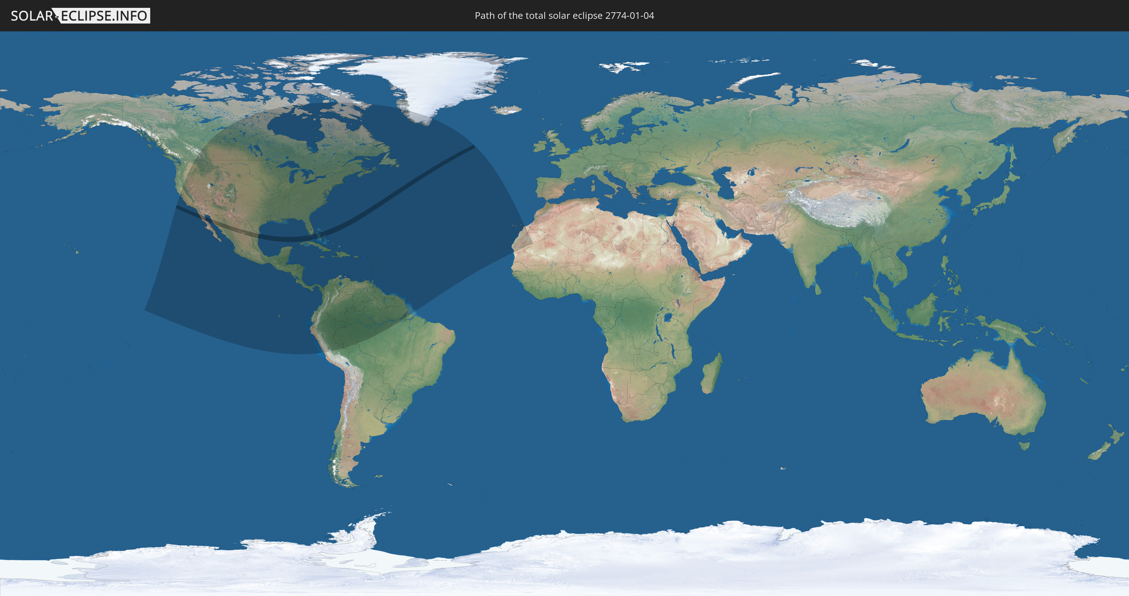
Die Sonnenfinsternis am 04.01.2774 kann man in 52 Ländern als partielle Sonnenfinsternis beobachten.
Der Finsternispfad verläuft durch 3 Länder. Nur in diesen Ländern ist sie als totale Sonnenfinsternis zu sehen.
In den folgenden Ländern ist die Sonnenfinsternis total zu sehen
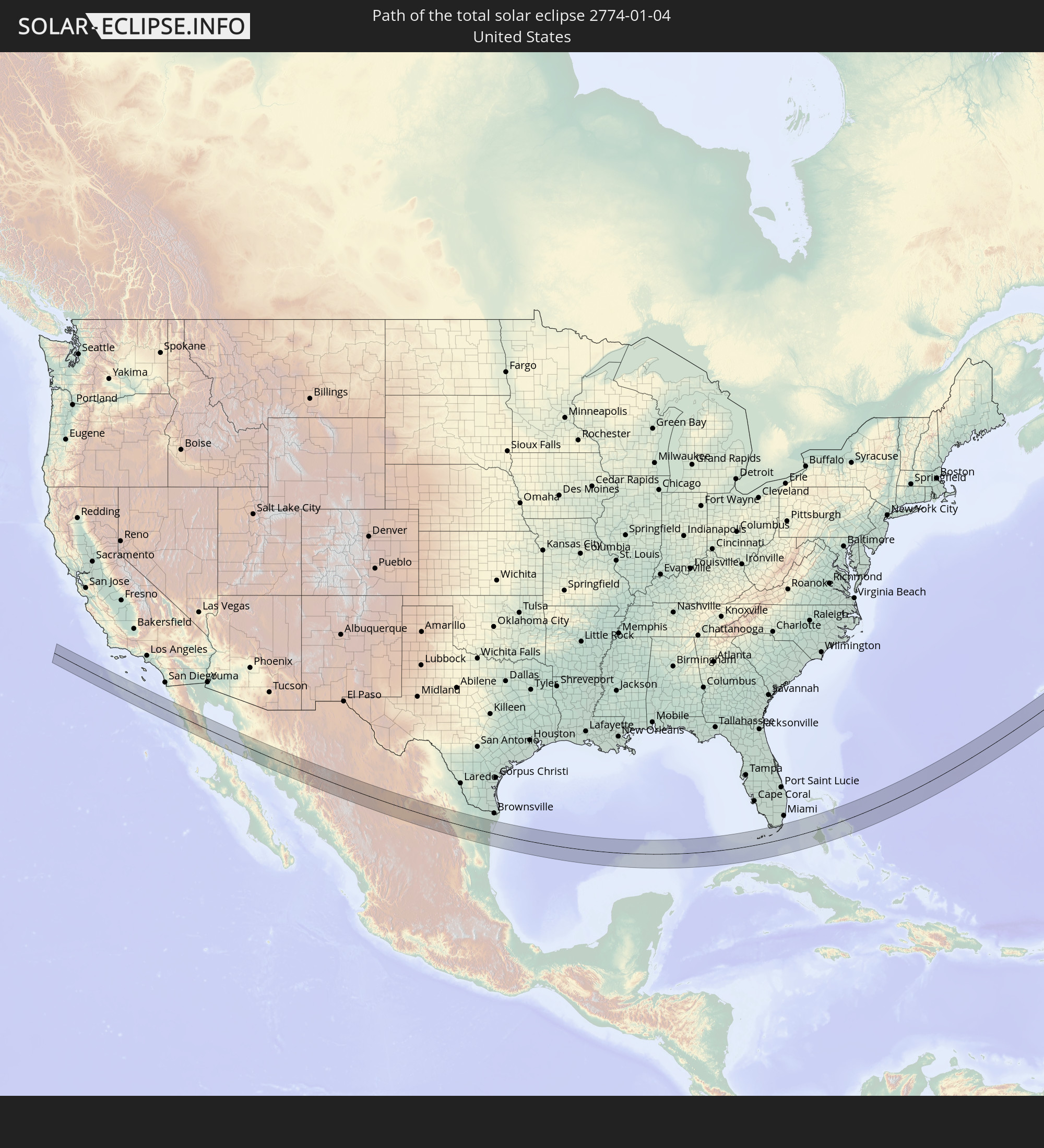 Vereinigte Staaten
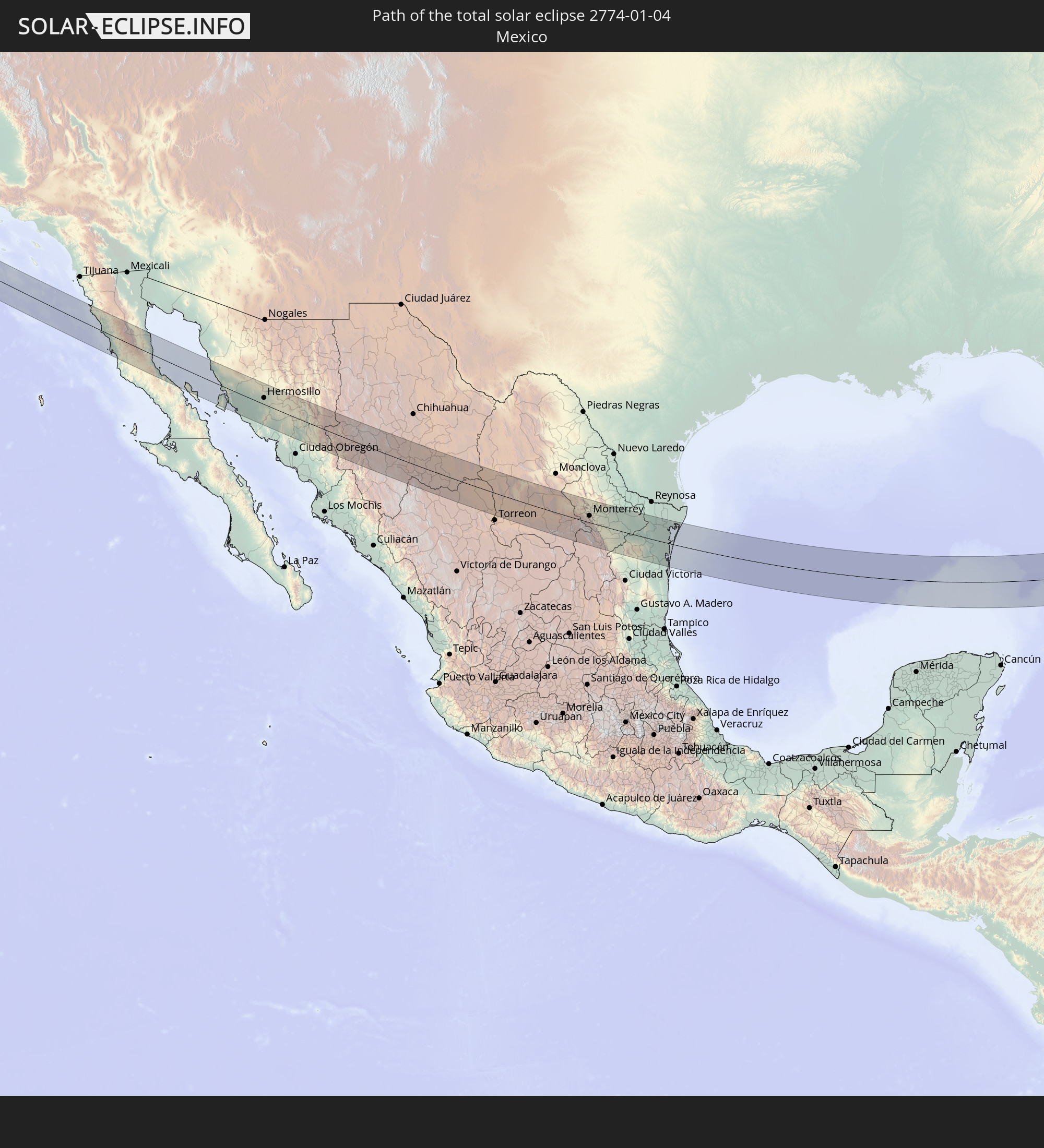 Mexiko
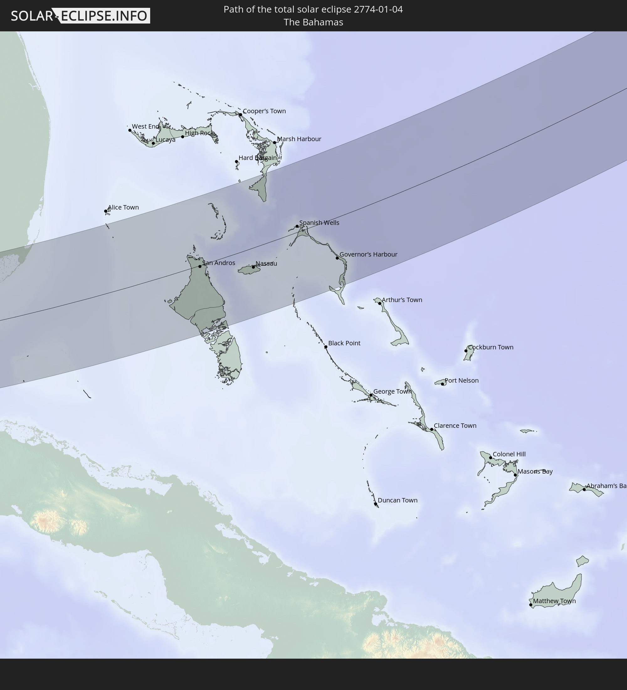 Bahamas
In den folgenden Ländern ist die Sonnenfinsternis partiell zu sehen
 Vereinigte Staaten
 United States Minor Outlying Islands
 Kanada
 Mexiko
 Grönland
 Guatemala
 Ecuador
 El Salvador
 Honduras
 Belize
 Nicaragua
 Costa Rica
 Kuba
Kuba
 Panama
 Kolumbien
 Kaimaninseln
 Peru
Peru
 Bahamas
 Jamaika
 Haiti
Haiti
 Brasilien
 Venezuela
 Turks- und Caicosinseln
 Dominikanische Republik
 Aruba
Aruba
 Puerto Rico
 Amerikanische Jungferninseln
 Bermuda
 Britische Jungferninseln
 Anguilla
 Saint-Martin
 Saint-Barthélemy
 St. Kitts und Nevis
 Antigua und Barbuda
 Montserrat
 Trinidad und Tobago
 Guadeloupe
 Grenada
 Dominica
 St. Vincent und die Grenadinen
 Guyana
 Martinique
 St. Lucia
 Barbados
 Suriname
 Saint-Pierre und Miquelon
 Französisch-Guayana
 Portugal
 Kap Verde
 Spanien
 Mauretanien
 Marokko
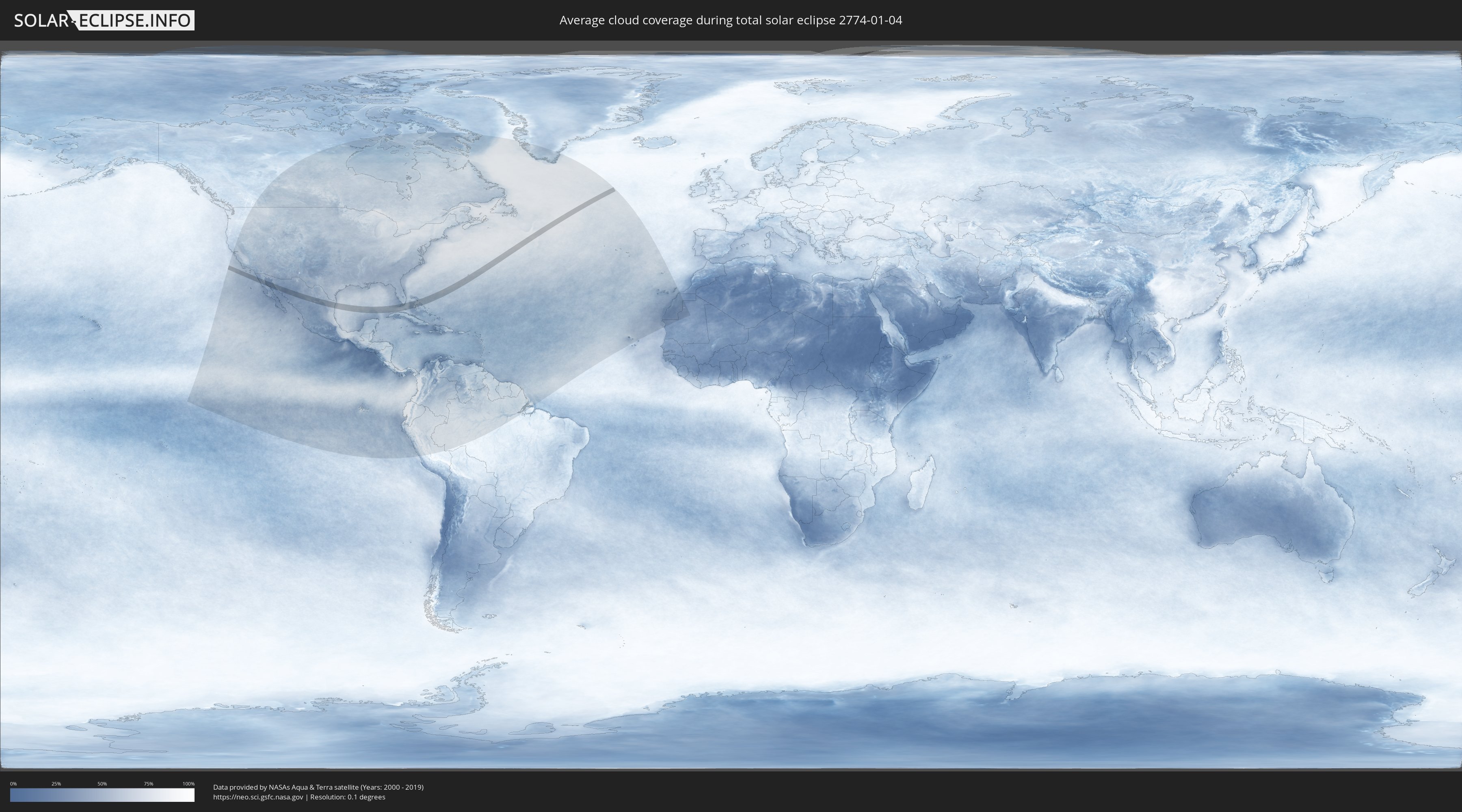
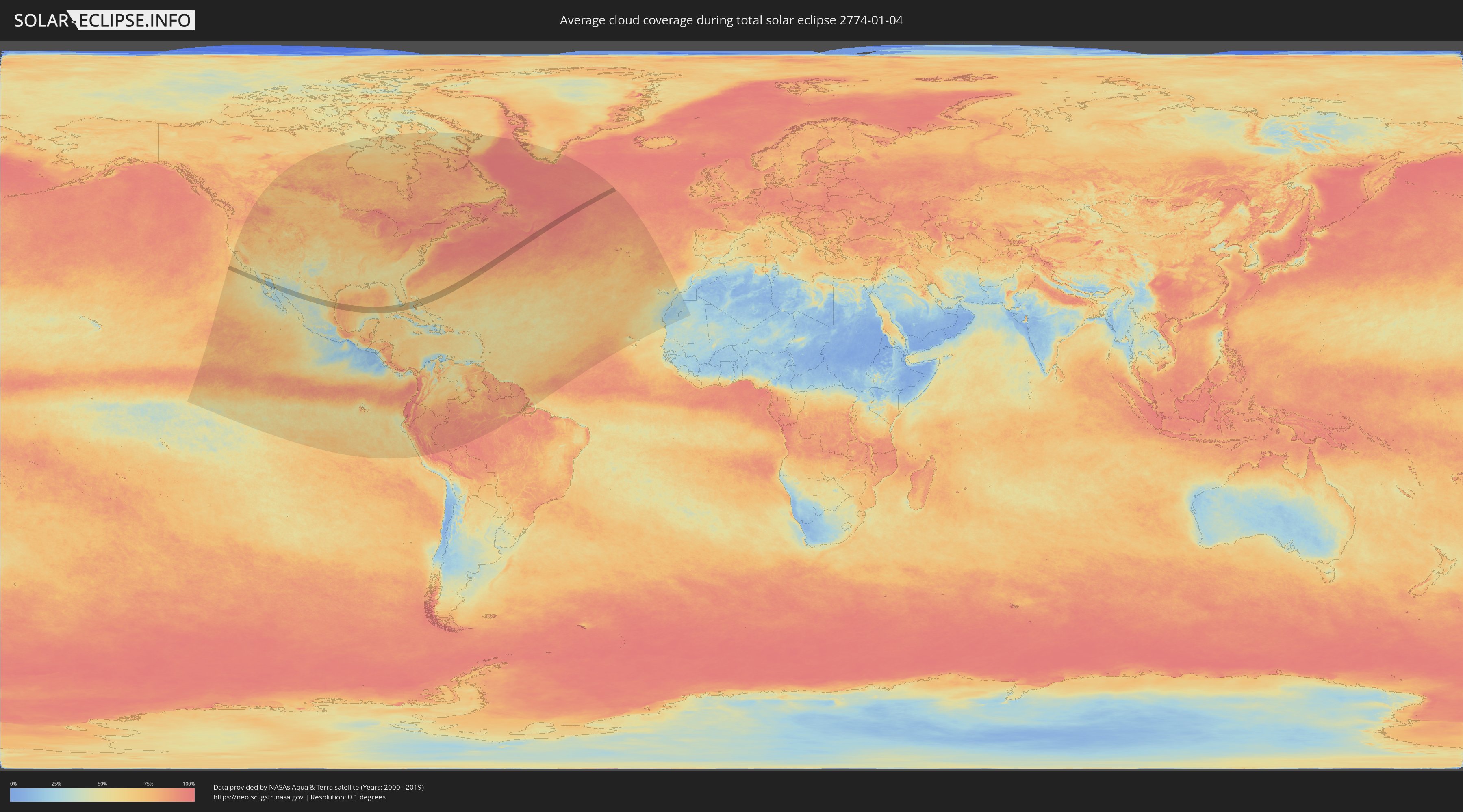
Wie wird das Wetter während der totalen Sonnenfinsternis am 04.01.2774?
Wo ist der beste Ort, um die totale Sonnenfinsternis vom 04.01.2774 zu beobachten?
Die folgenden Karten zeigen die durchschnittliche Bewölkung für den Tag, an dem die totale Sonnenfinsternis
stattfindet. Mit Hilfe der Karten lässt sich der Ort entlang des Finsternispfades eingrenzen,
der die besten Aussichen auf einen klaren wolkenfreien Himmel bietet.
Trotzdem muss man immer lokale Gegenenheiten beachten und sollte sich genau über das Wetter an seinem
gewählten Beobachtungsort informieren.
Die Daten stammen von den beiden NASA-Satelliten
AQUA und TERRA
und wurden über einen Zeitraum von 19 Jahren (2000 - 2019) gemittelt.
Detaillierte Länderkarten
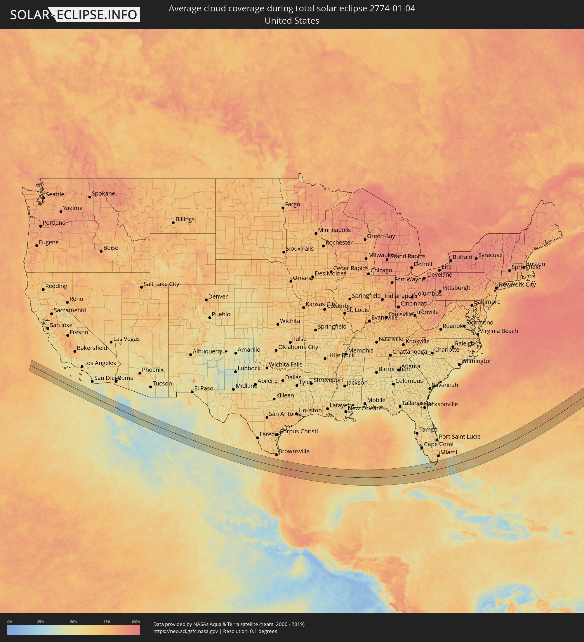 Vereinigte Staaten
 Mexiko
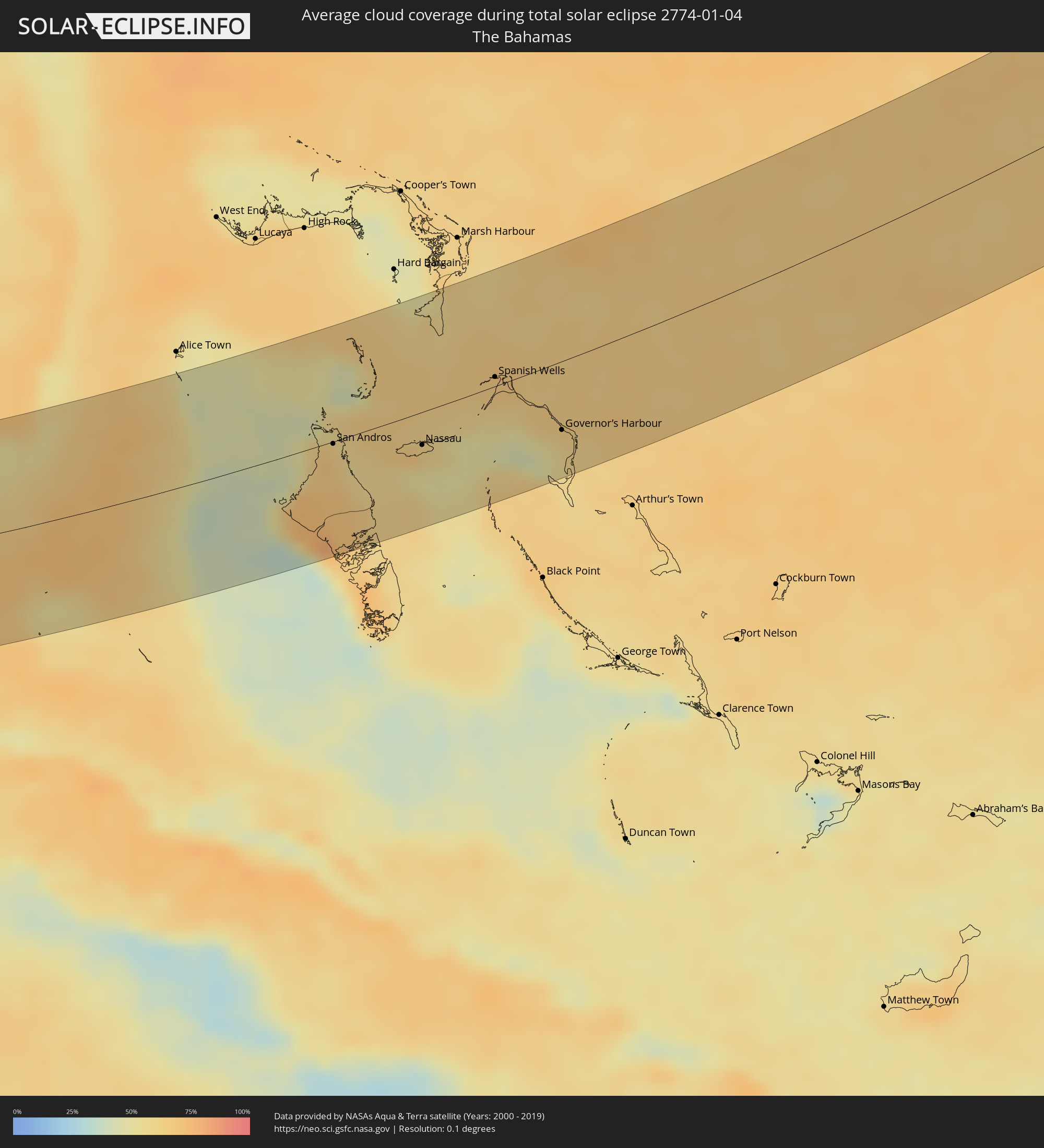 Bahamas
Orte im Finsternispfad
Die nachfolgene Tabelle zeigt Städte und Orte mit mehr als 5.000 Einwohnern, die sich im Finsternispfad befinden. Städte mit mehr als 100.000 Einwohnern sind dick gekennzeichnet. Mit einem Klick auf den Ort öffnet sich eine Detailkarte die die Lage des jeweiligen Ortes zusammen mit dem Verlauf der zentralen Finsternis präsentiert.
| Ort | Typ | Dauer der Verfinsterung | Ortszeit bei maximaler Verfinsterung | Entfernung zur Zentrallinie | Ø Bewölkung |
|
Camalú, Baja California
|
total | - | 07:25:33 UTC-08:00 | 7 km | 41% |
|
Emiliano Zapata, Baja California
|
total | - | 07:25:30 UTC-08:00 | 13 km | 43% |
|
Vicente Guerrero, Baja California
|
total | - | 07:25:29 UTC-08:00 | 15 km | 50% |
|
San Quintín, Baja California
|
total | - | 07:25:19 UTC-08:00 | 31 km | 52% |
|
Bahía de Kino, Sonora
|
total | - | 08:27:07 UTC-07:00 | 47 km | 39% |
|
Miguel Alemán (La Doce), Sonora
|
total | - | 08:27:37 UTC-07:00 | 27 km | 48% |
|
Hermosillo, Sonora
|
total | - | 08:28:26 UTC-07:00 | 19 km | 47% |
|
Pesqueira, Sonora
|
total | - | 08:28:50 UTC-07:00 | 50 km | 40% |
|
Creel, Chihuahua
|
total | - | 08:30:51 UTC-07:00 | 4 km | 37% |
|
Santa Bárbara, Chihuahua
|
total | - | 08:32:13 UTC-07:00 | 31 km | 39% |
|
Hidalgo del Parral, Chihuahua
|
total | - | 08:32:33 UTC-07:00 | 13 km | 38% |
|
Bermejillo, Durango
|
total | - | 09:34:22 UTC-06:00 | 55 km | 50% |
|
Poanas, Durango
|
total | - | 09:34:16 UTC-06:00 | 67 km | 49% |
|
Tlahualilo de Zaragoza, Durango
|
total | - | 09:34:51 UTC-06:00 | 26 km | 49% |
|
San Antonio del Coyote, Coahuila
|
total | - | 09:34:40 UTC-06:00 | 64 km | 49% |
|
Coyote, Coahuila
|
total | - | 09:34:40 UTC-06:00 | 64 km | 49% |
|
Concordia, Coahuila
|
total | - | 09:35:00 UTC-06:00 | 50 km | 44% |
|
Parras de la Fuente, Coahuila
|
total | - | 09:36:06 UTC-06:00 | 57 km | 40% |
|
Saltillo, Coahuila
|
total | - | 09:37:57 UTC-06:00 | 25 km | 38% |
|
Ramos Arizpe, Coahuila
|
total | - | 09:38:10 UTC-06:00 | 11 km | 42% |
|
Arteaga, Coahuila
|
total | - | 09:38:14 UTC-06:00 | 18 km | 39% |
|
García, Nuevo León
|
total | - | 09:39:02 UTC-06:00 | 28 km | 53% |
|
Valle de Lincoln, Nuevo León
|
total | - | 09:39:12 UTC-06:00 | 30 km | 58% |
|
Santa Catarina, Nuevo León
|
total | - | 09:39:07 UTC-06:00 | 17 km | 47% |
|
Parque Industrial Ciudad Mitras, Nuevo León
|
total | - | 09:39:15 UTC-06:00 | 30 km | 61% |
|
Mitras Poniente, Nuevo León
|
total | - | 09:39:16 UTC-06:00 | 29 km | 61% |
|
San Pedro Garza Garcia, Nuevo León
|
total | - | 09:39:11 UTC-06:00 | 17 km | 52% |
|
Garza García, Nuevo León
|
total | - | 09:39:14 UTC-06:00 | 17 km | 52% |
|
Monterrey, Nuevo León
|
total | - | 09:39:21 UTC-06:00 | 21 km | 58% |
|
General Escobedo, Nuevo León
|
total | - | 09:39:29 UTC-06:00 | 34 km | 64% |
|
San Nicolás de los Garza, Nuevo León
|
total | - | 09:39:27 UTC-06:00 | 29 km | 58% |
|
Emiliano Zapata, Nuevo León
|
total | - | 09:39:39 UTC-06:00 | 48 km | 58% |
|
Guadalupe, Nuevo León
|
total | - | 09:39:27 UTC-06:00 | 23 km | 58% |
|
Jardines de la Silla (Jardines), Nuevo León
|
total | - | 09:39:31 UTC-06:00 | 20 km | 53% |
|
Villas de Alcalá, Nuevo León
|
total | - | 09:39:49 UTC-06:00 | 51 km | 59% |
|
Real del Sol, Nuevo León
|
total | - | 09:39:51 UTC-06:00 | 53 km | 59% |
|
Ciénega de Flores, Nuevo León
|
total | - | 09:39:53 UTC-06:00 | 55 km | 53% |
|
Apodaca, Nuevo León
|
total | - | 09:39:42 UTC-06:00 | 35 km | 65% |
|
Fraccionamiento Real Palmas, Nuevo León
|
total | - | 09:39:51 UTC-06:00 | 50 km | 59% |
|
Monte Kristal, Nuevo León
|
total | - | 09:39:34 UTC-06:00 | 21 km | 53% |
|
Santiago, Nuevo León
|
total | - | 09:39:22 UTC-06:00 | 1 km | 46% |
|
Misión San Pablo, Nuevo León
|
total | - | 09:39:42 UTC-06:00 | 33 km | 59% |
|
Loma la Paz, Nuevo León
|
total | - | 09:39:42 UTC-06:00 | 30 km | 59% |
|
Héctor Caballero, Nuevo León
|
total | - | 09:39:38 UTC-06:00 | 22 km | 55% |
|
General Zuazua, Nuevo León
|
total | - | 09:39:56 UTC-06:00 | 51 km | 56% |
|
Juárez, Nuevo León
|
total | - | 09:39:42 UTC-06:00 | 25 km | 55% |
|
Galeana, Nuevo León
|
total | - | 09:38:54 UTC-06:00 | 63 km | 42% |
|
Pesquería, Nuevo León
|
total | - | 09:39:55 UTC-06:00 | 40 km | 60% |
|
Allende, Nuevo León
|
total | - | 09:39:27 UTC-06:00 | 13 km | 53% |
|
Cadereyta, Nuevo León
|
total | - | 09:39:49 UTC-06:00 | 21 km | 55% |
|
Montemorelos, Nuevo León
|
total | - | 09:39:41 UTC-06:00 | 17 km | 56% |
|
General Teran, Nuevo León
|
total | - | 09:40:00 UTC-06:00 | 6 km | 57% |
|
Hualahuises, Nuevo León
|
total | - | 09:39:39 UTC-06:00 | 46 km | 56% |
|
Hidalgo, Nuevo León
|
total | - | 09:40:43 UTC-06:00 | 60 km | 55% |
|
Linares, Nuevo León
|
total | - | 09:39:48 UTC-06:00 | 46 km | 58% |
|
La Reforma, Nuevo León
|
total | - | 09:39:41 UTC-06:00 | 62 km | 54% |
|
China, Nuevo León
|
total | - | 09:41:13 UTC-06:00 | 53 km | 56% |
|
San Fernando, Tamaulipas
|
total | - | 09:42:17 UTC-06:00 | 11 km | 69% |
|
Key West, Florida
|
total | - | 11:18:52 UTC-05:00 | 37 km | 49% |
|
Marathon, Florida
|
total | - | 11:20:48 UTC-05:00 | 40 km | 51% |
|
Islamorada, Florida
|
total | - | 11:22:11 UTC-05:00 | 53 km | 55% |
|
Key Largo, Florida
|
total | - | 11:22:48 UTC-05:00 | 66 km | 52% |
|
San Andros, North Andros
|
total | - | 11:29:03 UTC-05:00 | 2 km | 67% |
|
Nassau, New Providence
|
total | - | 11:30:54 UTC-05:00 | 25 km | 60% |
|
Spanish Wells, Spanish Wells
|
total | - | 11:32:48 UTC-05:00 | 7 km | 62% |
|
Governor’s Harbour, Central Eleuthera
|
total | - | 16:33:54 UTC+00:00 | 51 km | 60% |