Totale Sonnenfinsternis vom 26.12.2782
| Wochentag: | Sonntag |
| Maximale Dauer der Verfinsterung: | 04m10s |
| Maximale Breite des Finsternispfades: | 183 km |
| Saroszyklus: | 154 |
| Bedeckungsgrad: | 100% |
| Magnitude: | 1.0435 |
| Gamma: | 0.607 |
Wo kann man die Sonnenfinsternis vom 26.12.2782 sehen?
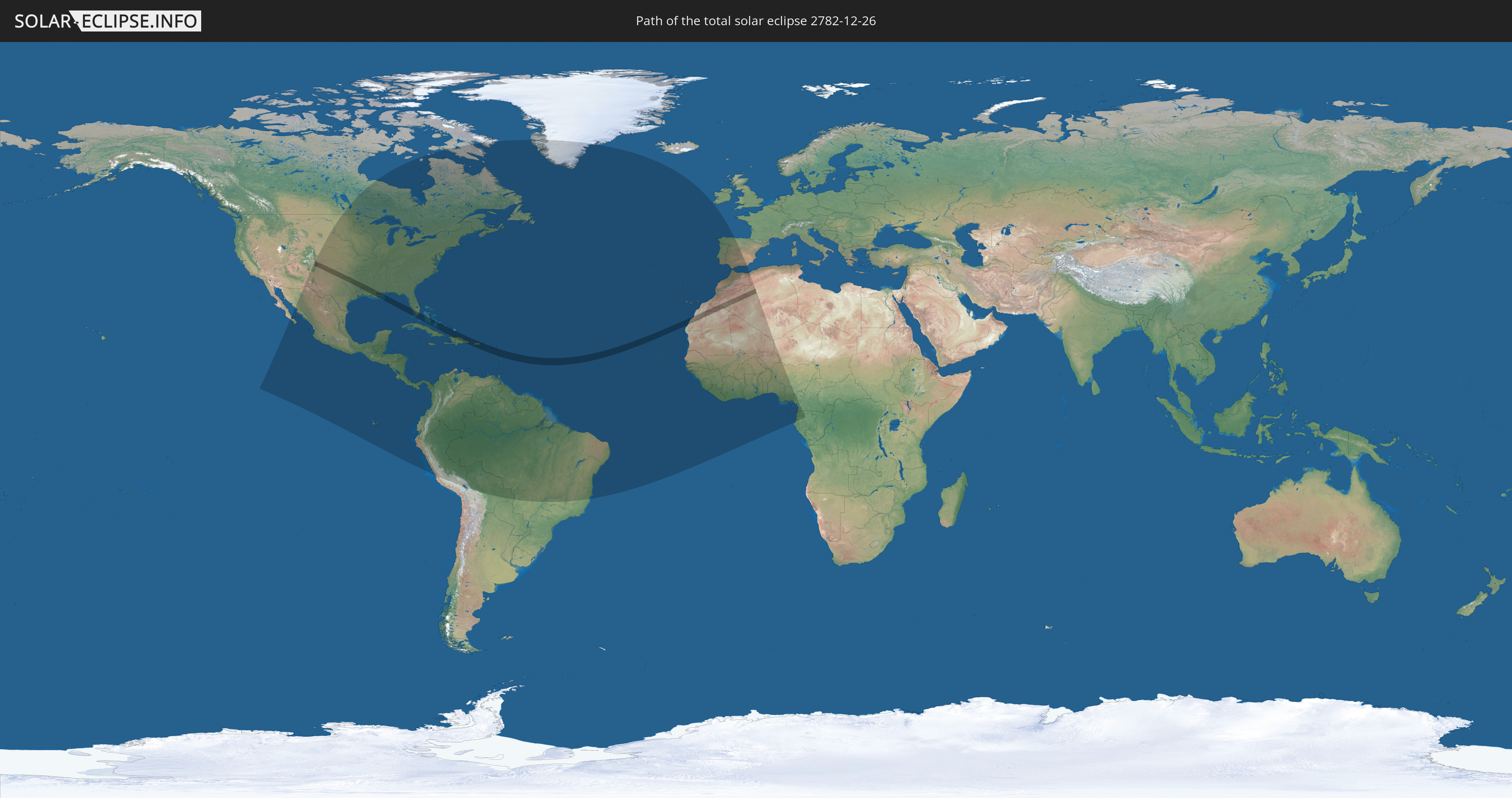
Die Sonnenfinsternis am 26.12.2782 kann man in 75 Ländern als partielle Sonnenfinsternis beobachten.
Der Finsternispfad verläuft durch 15 Länder. Nur in diesen Ländern ist sie als totale Sonnenfinsternis zu sehen.
In den folgenden Ländern ist die Sonnenfinsternis total zu sehen
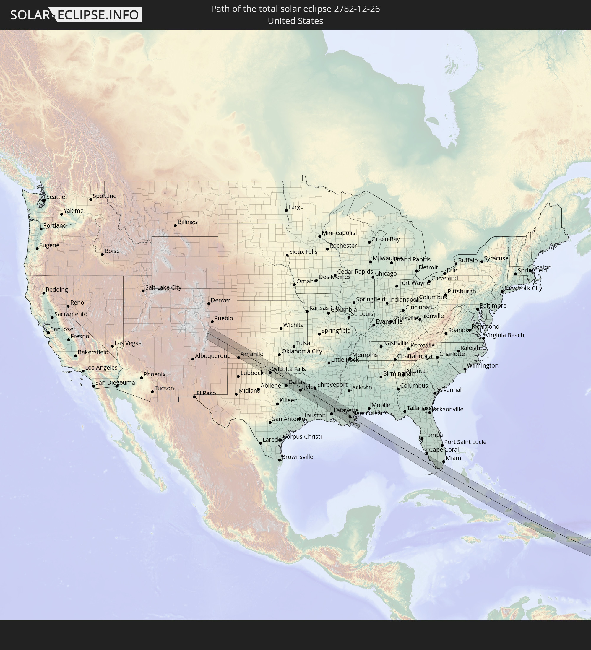 Vereinigte Staaten
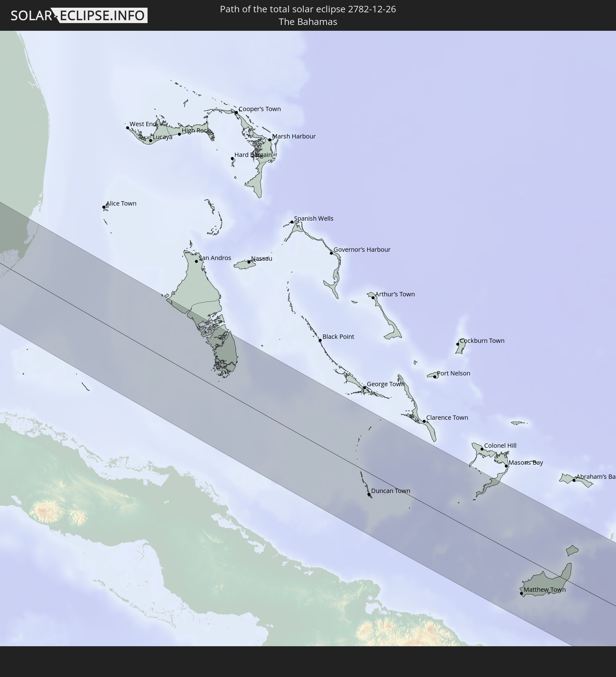 Bahamas
 Haiti
Haiti
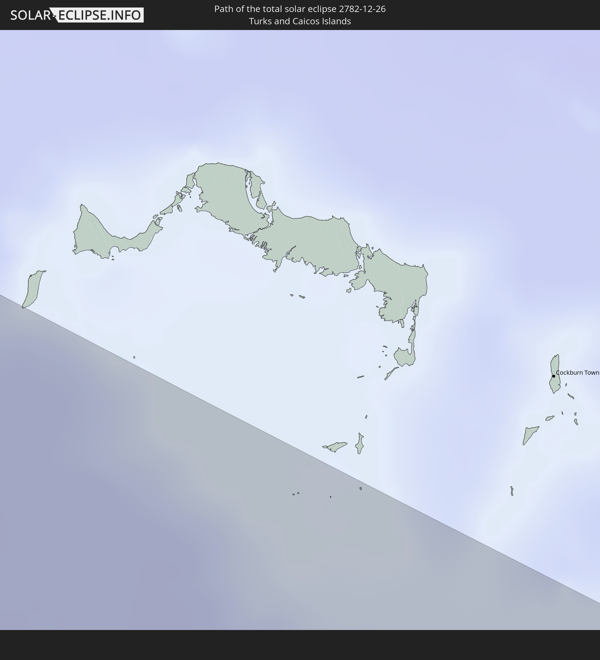 Turks- und Caicosinseln
 Dominikanische Republik
 Puerto Rico
 Amerikanische Jungferninseln
 St. Kitts und Nevis
 Antigua und Barbuda
 Montserrat
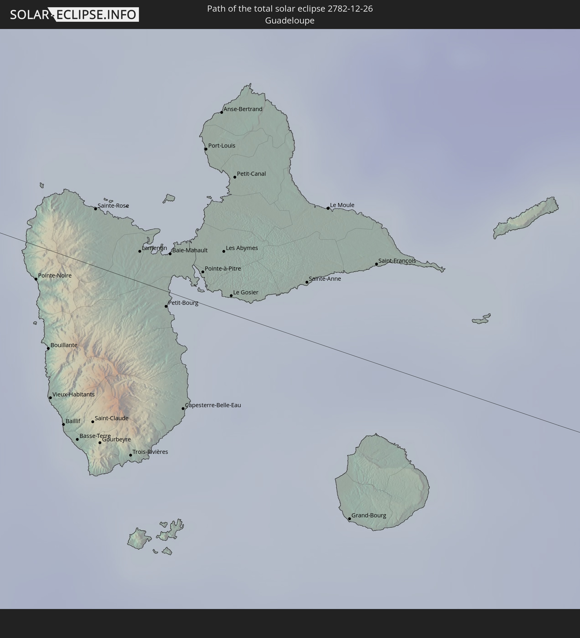 Guadeloupe
 Dominica
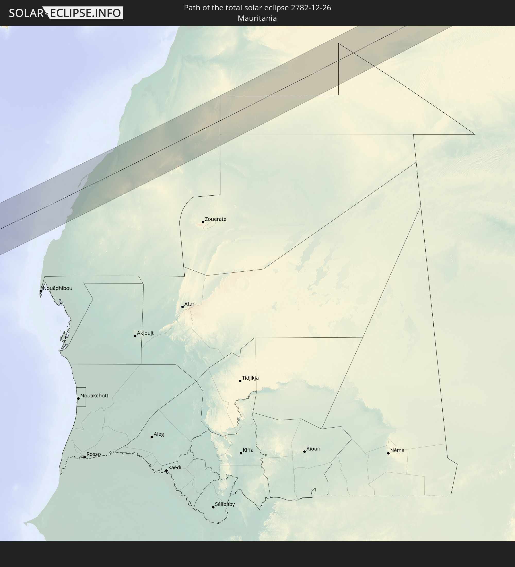 Mauretanien
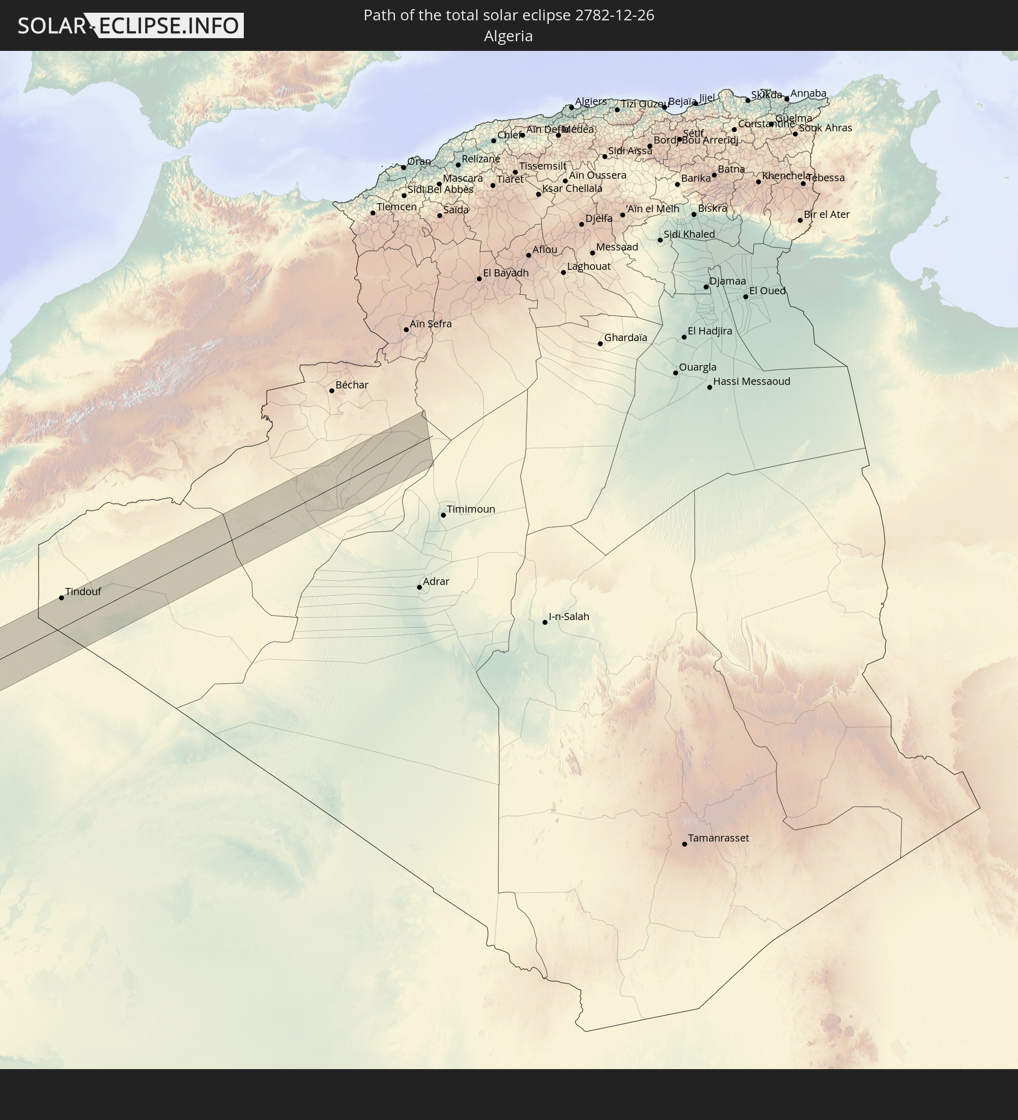 Algerien
 Besondere Gemeinde (Niederlande)
In den folgenden Ländern ist die Sonnenfinsternis partiell zu sehen
 Vereinigte Staaten
 United States Minor Outlying Islands
 Kanada
 Mexiko
 Grönland
 Guatemala
 Ecuador
 El Salvador
 Honduras
 Belize
 Nicaragua
 Costa Rica
 Kuba
Kuba
 Panama
 Kolumbien
 Kaimaninseln
 Peru
Peru
 Bahamas
 Jamaika
 Haiti
Haiti
 Brasilien
 Venezuela
 Turks- und Caicosinseln
 Dominikanische Republik
 Aruba
Aruba
 Bolivien
 Puerto Rico
 Amerikanische Jungferninseln
 Bermuda
 Britische Jungferninseln
 Anguilla
 Saint-Martin
 Saint-Barthélemy
 St. Kitts und Nevis
 Antigua und Barbuda
 Montserrat
 Trinidad und Tobago
 Guadeloupe
 Grenada
 Dominica
 St. Vincent und die Grenadinen
 Guyana
 Martinique
 St. Lucia
 Barbados
 Suriname
 Saint-Pierre und Miquelon
 Französisch-Guayana
 Portugal
 Kap Verde
 Spanien
 Senegal
 Mauretanien
 Gambia
 Guinea-Bissau
 Guinea
 St. Helena
 Sierra Leone
 Marokko
 Mali
Mali
 Liberia
 Irland
 Algerien
 Elfenbeinküste
 Burkina Faso
 Gibraltar
 Ghana
Ghana
 Togo
Togo
 Niger
Niger
 Benin
Benin
 Nigeria
 Äquatorialguinea
 São Tomé und Príncipe
 Kamerun
 Gabun
Gabun
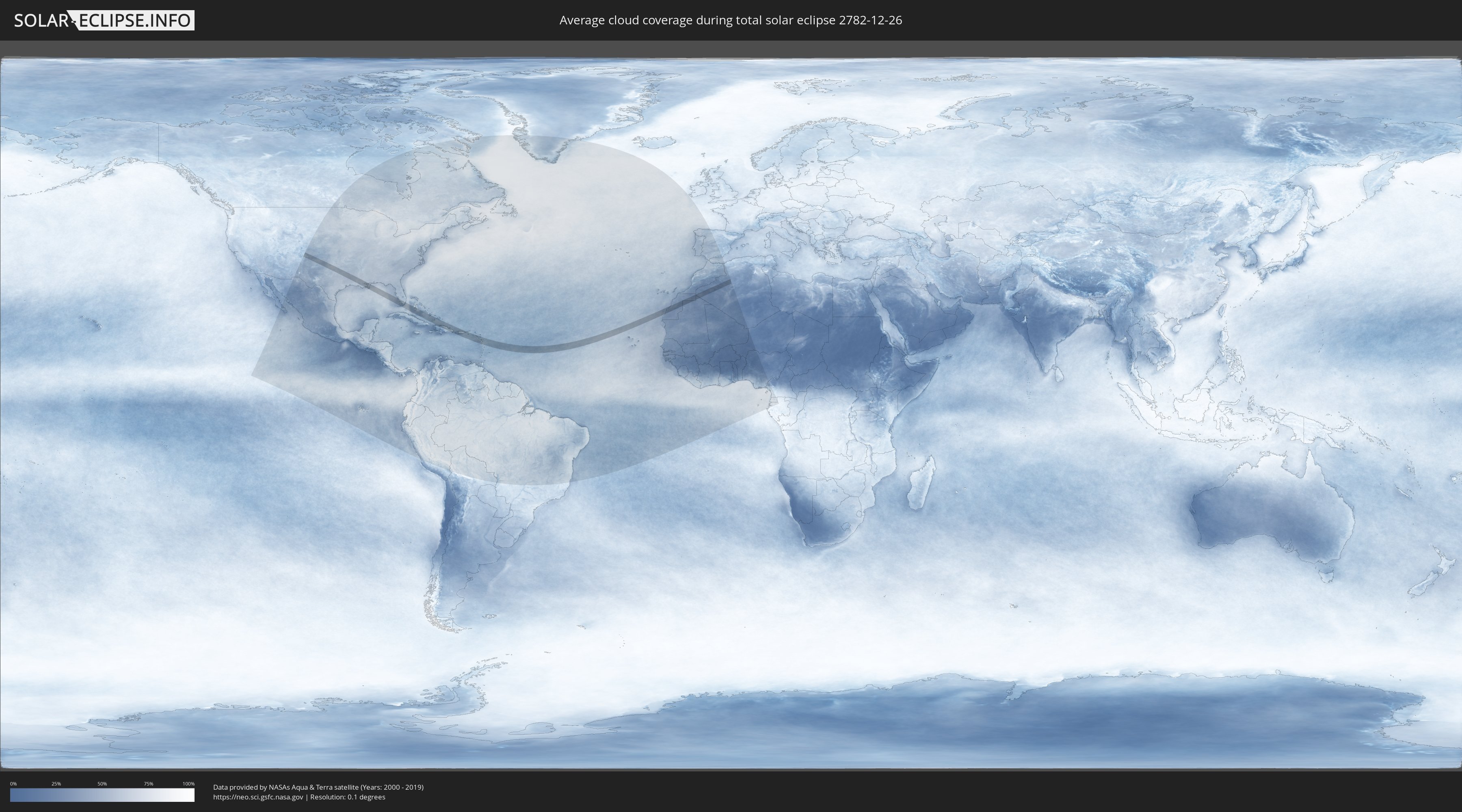
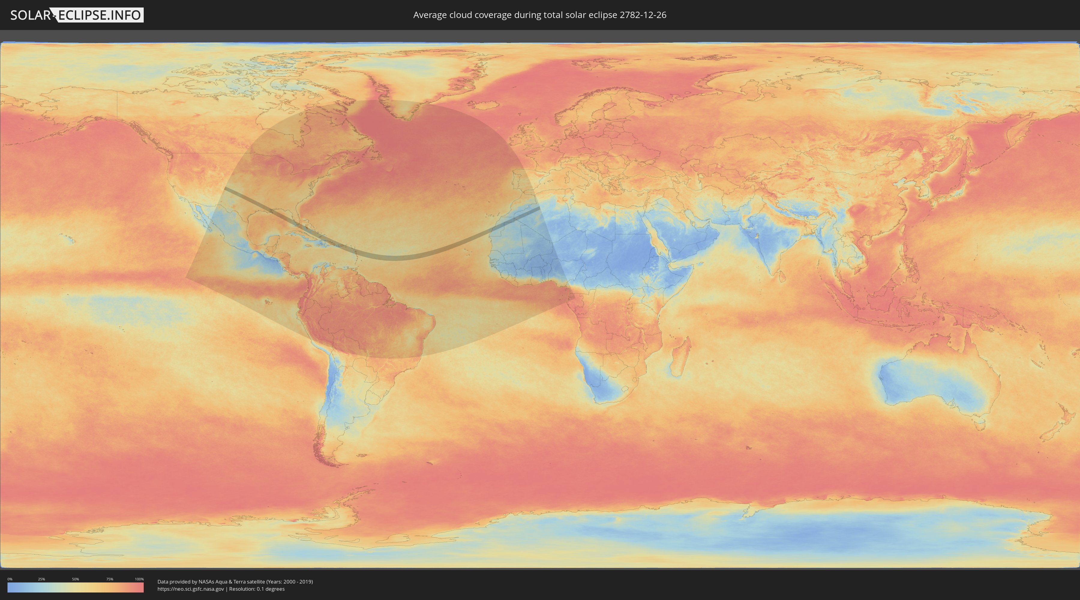
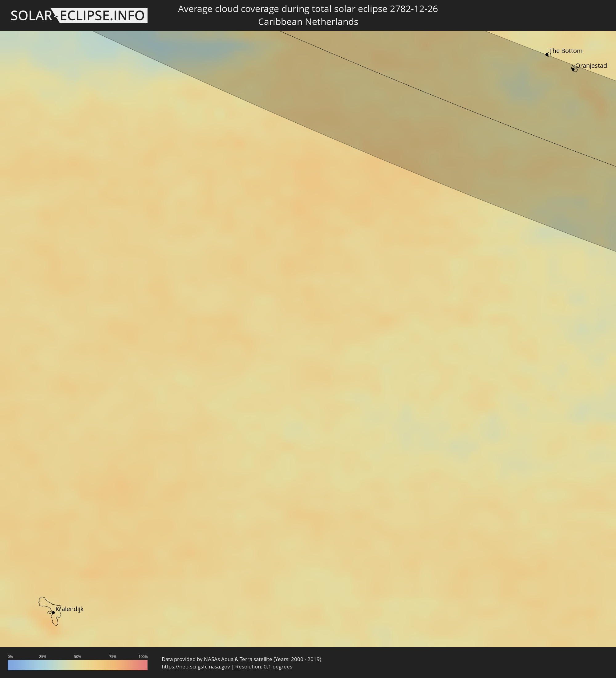
Wie wird das Wetter während der totalen Sonnenfinsternis am 26.12.2782?
Wo ist der beste Ort, um die totale Sonnenfinsternis vom 26.12.2782 zu beobachten?
Die folgenden Karten zeigen die durchschnittliche Bewölkung für den Tag, an dem die totale Sonnenfinsternis
stattfindet. Mit Hilfe der Karten lässt sich der Ort entlang des Finsternispfades eingrenzen,
der die besten Aussichen auf einen klaren wolkenfreien Himmel bietet.
Trotzdem muss man immer lokale Gegenenheiten beachten und sollte sich genau über das Wetter an seinem
gewählten Beobachtungsort informieren.
Die Daten stammen von den beiden NASA-Satelliten
AQUA und TERRA
und wurden über einen Zeitraum von 19 Jahren (2000 - 2019) gemittelt.
Detaillierte Länderkarten
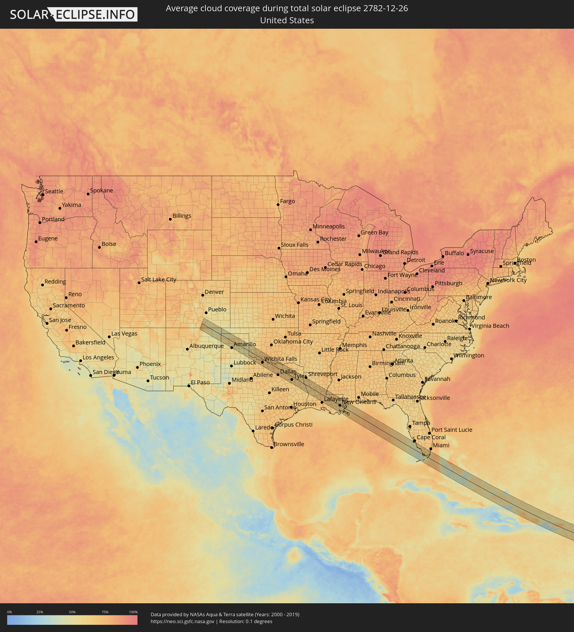 Vereinigte Staaten
 Bahamas
 Haiti
Haiti
 Turks- und Caicosinseln
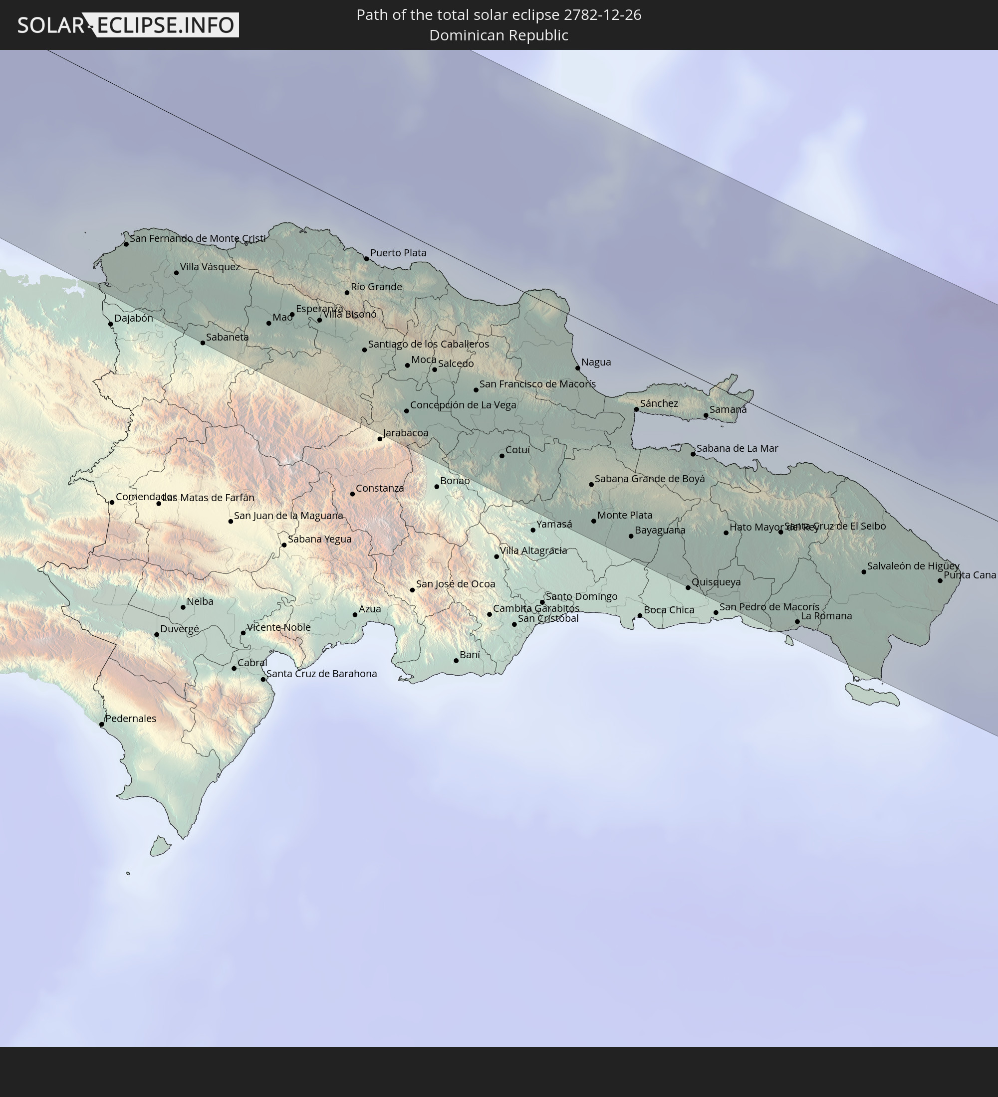
 Dominikanische Republik
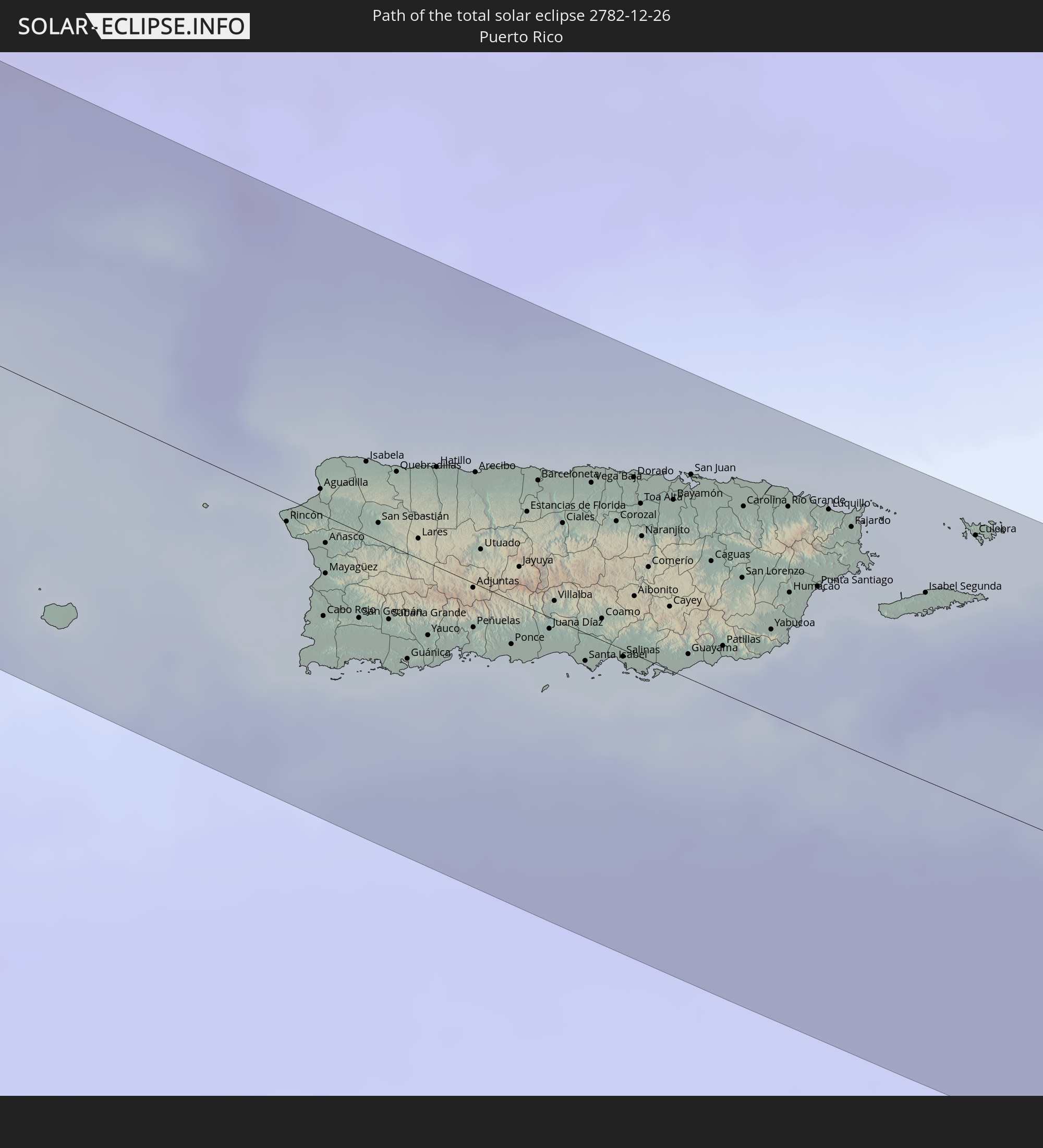
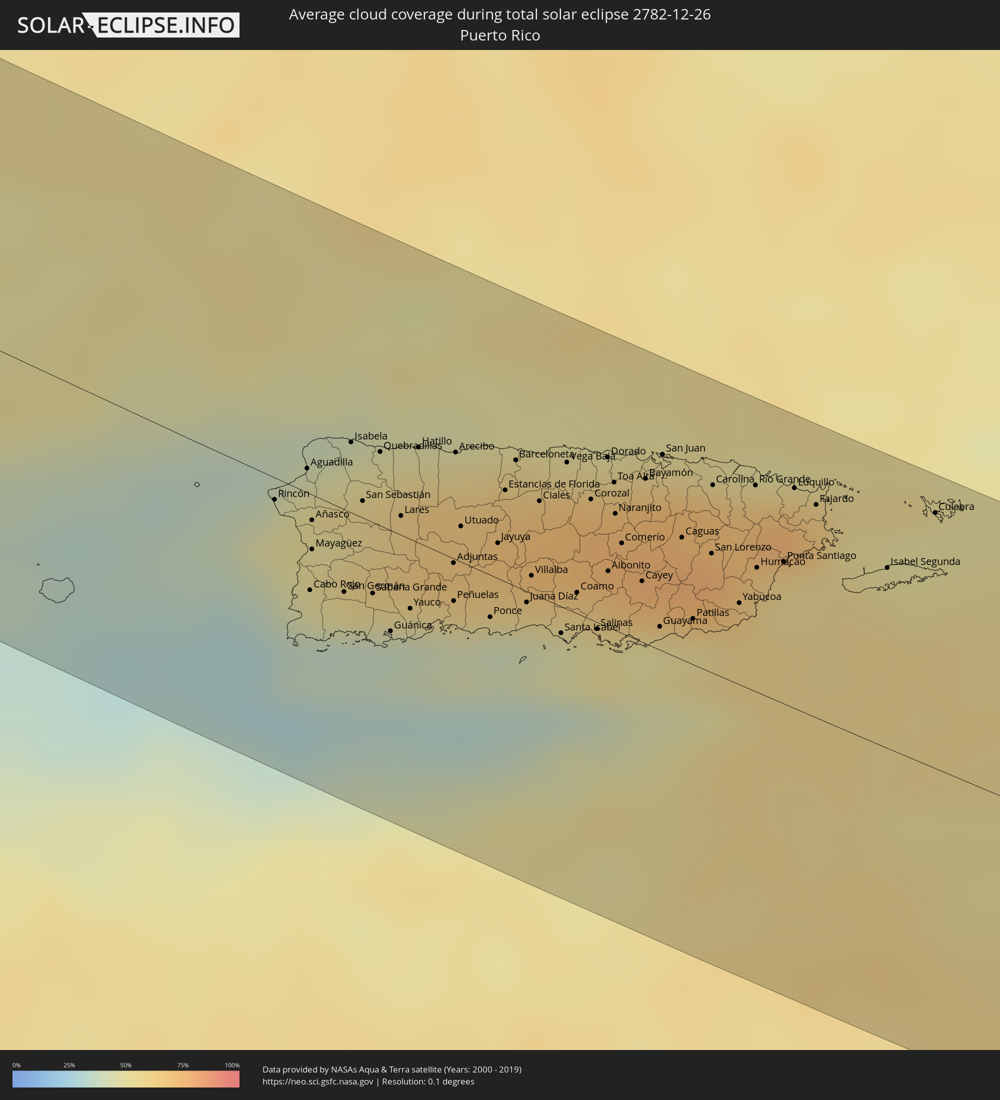 Puerto Rico
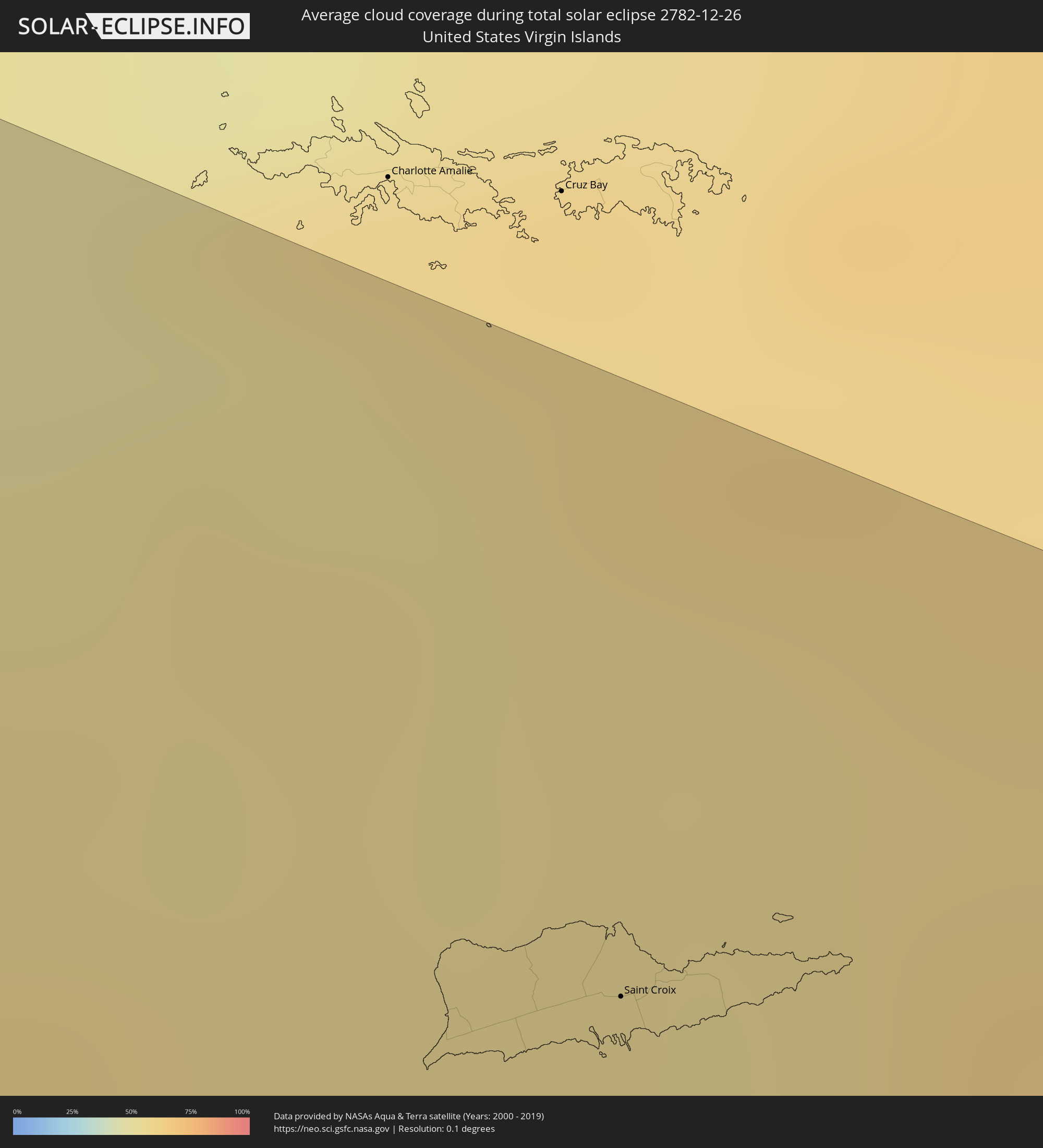 Amerikanische Jungferninseln
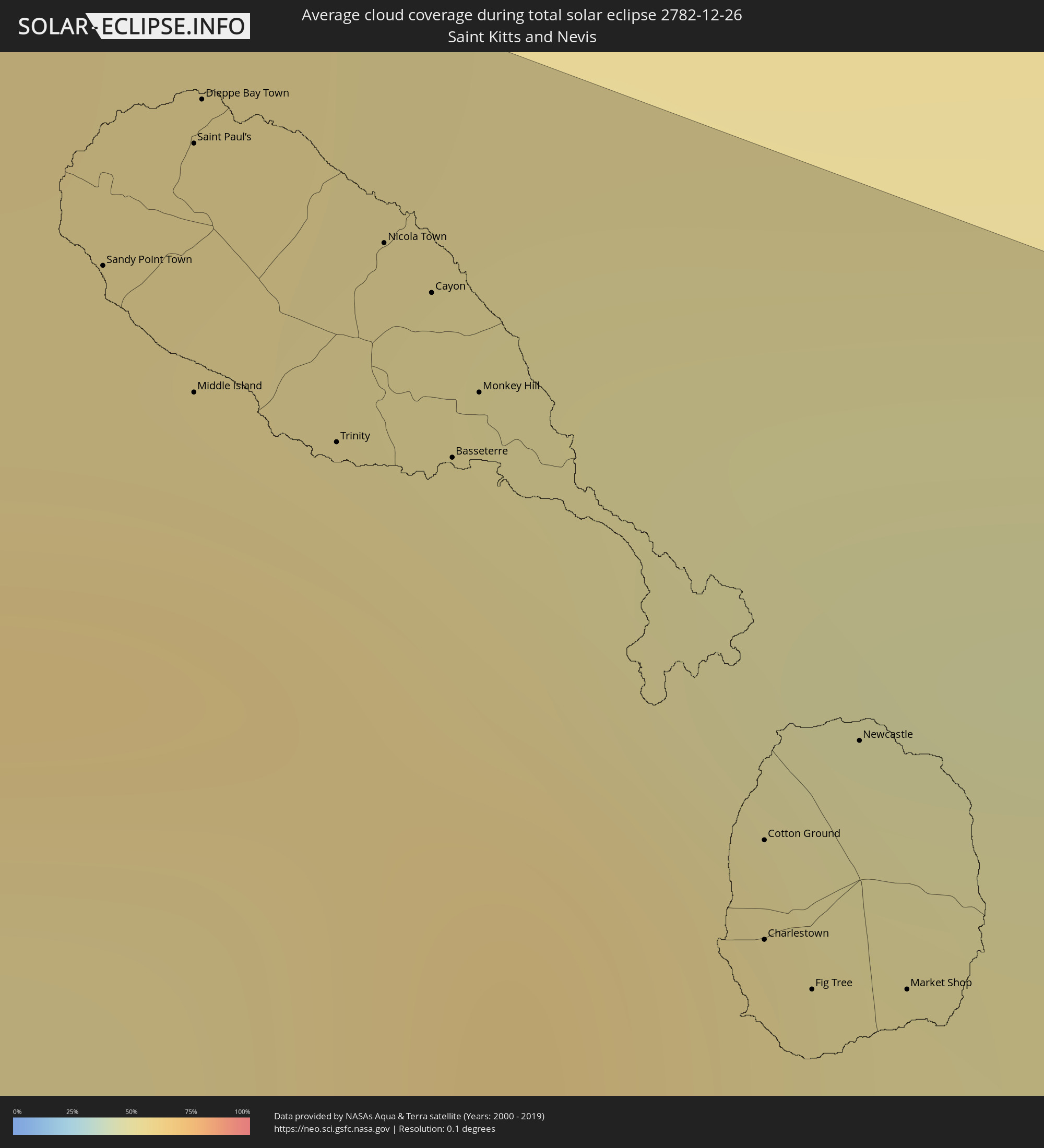 St. Kitts und Nevis
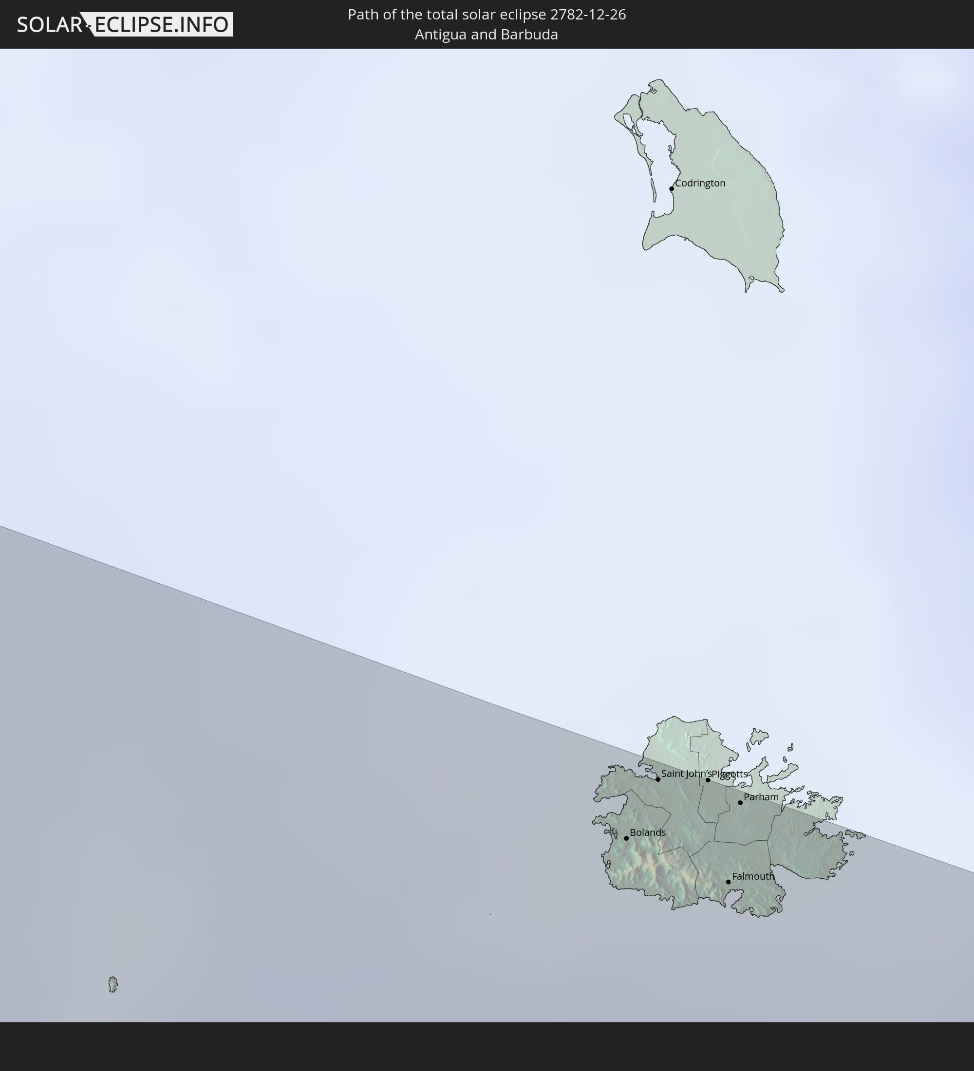
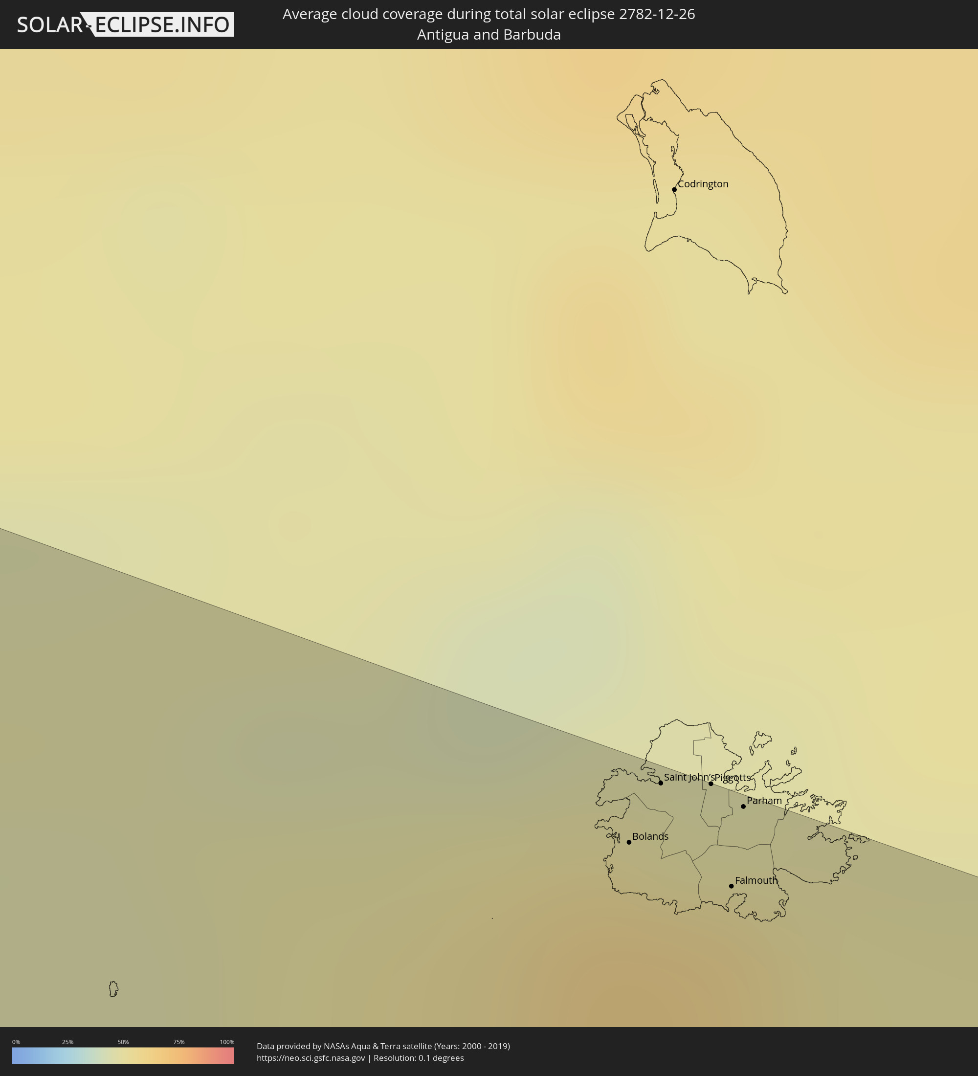 Antigua und Barbuda
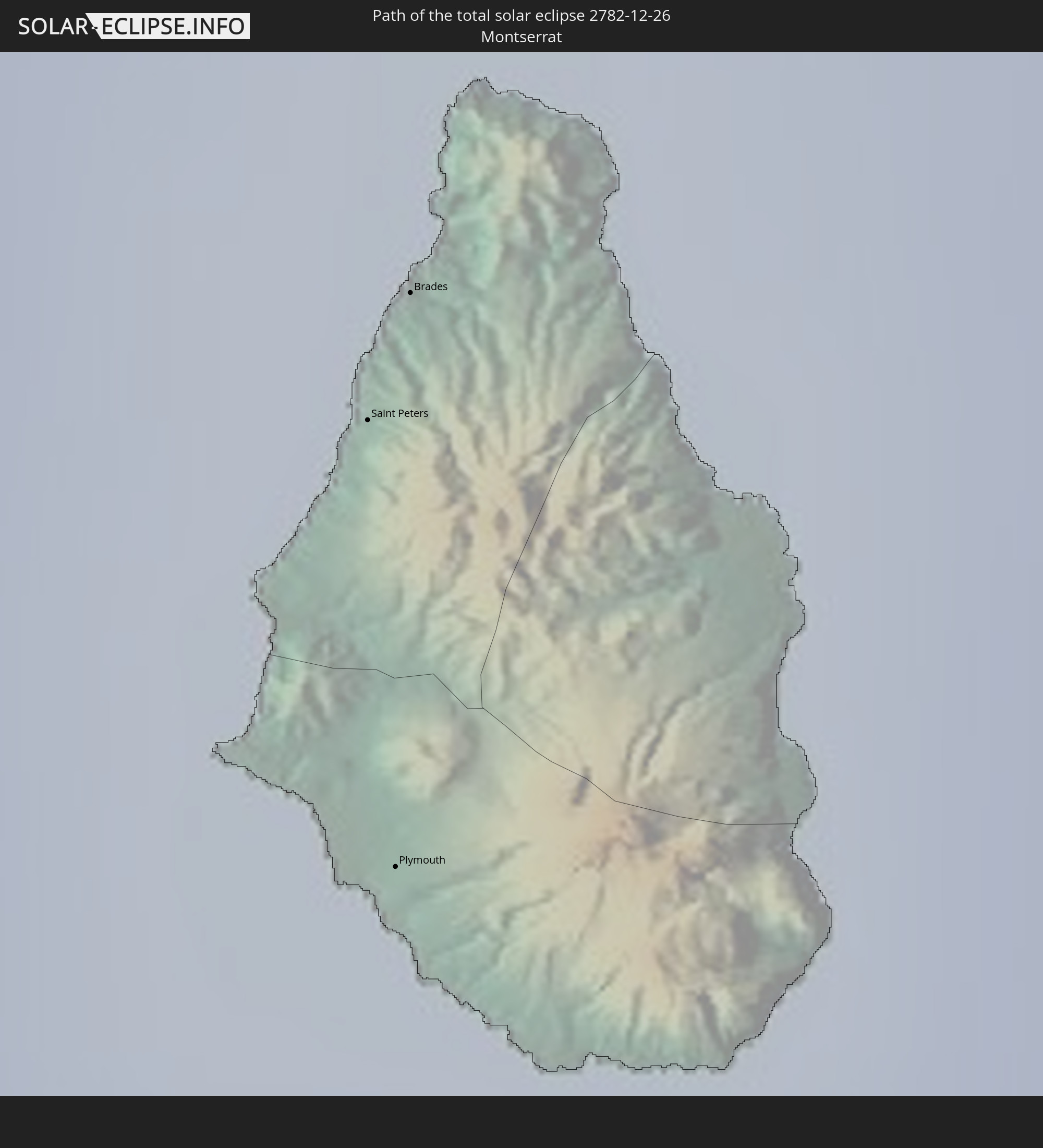
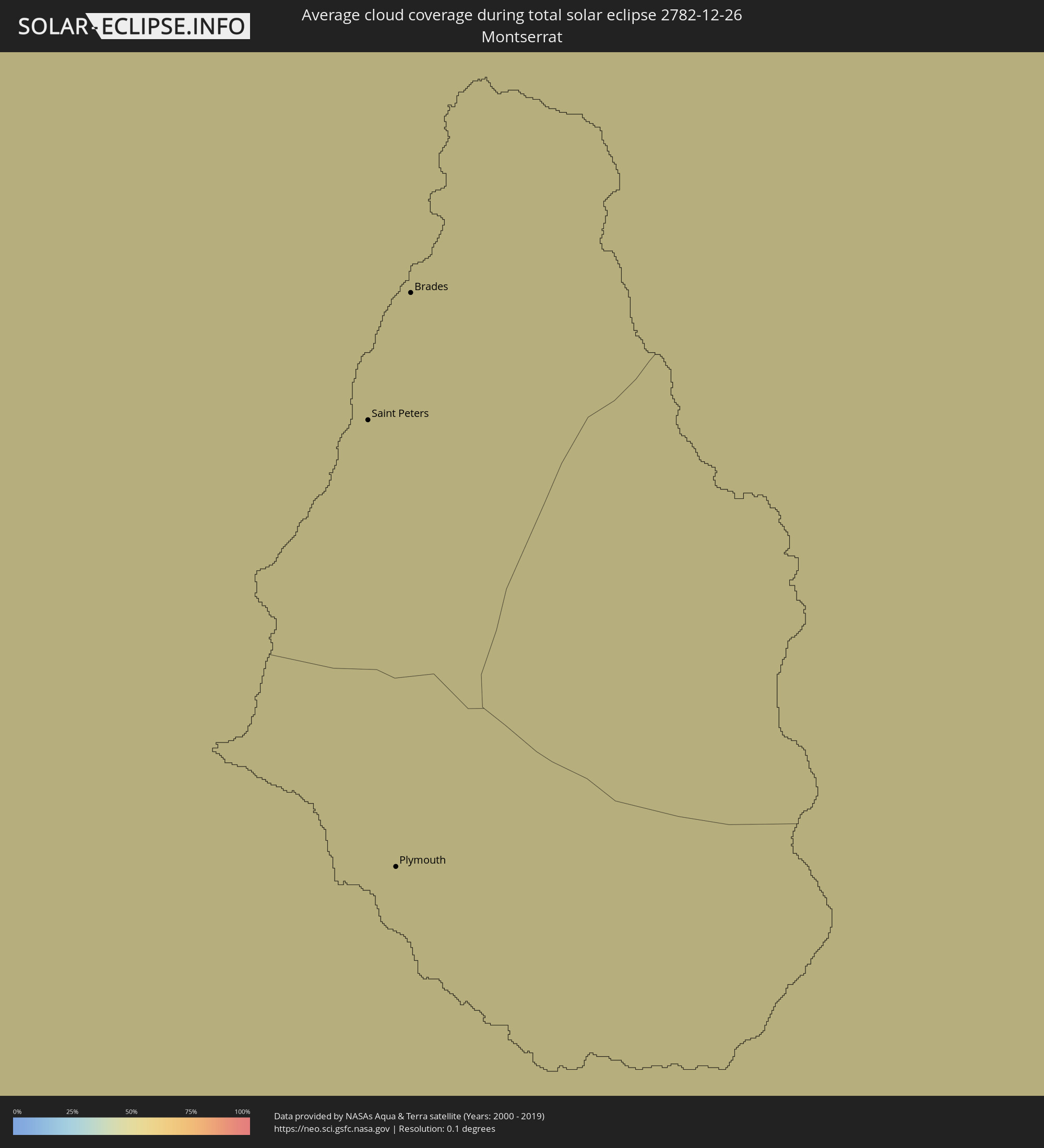 Montserrat
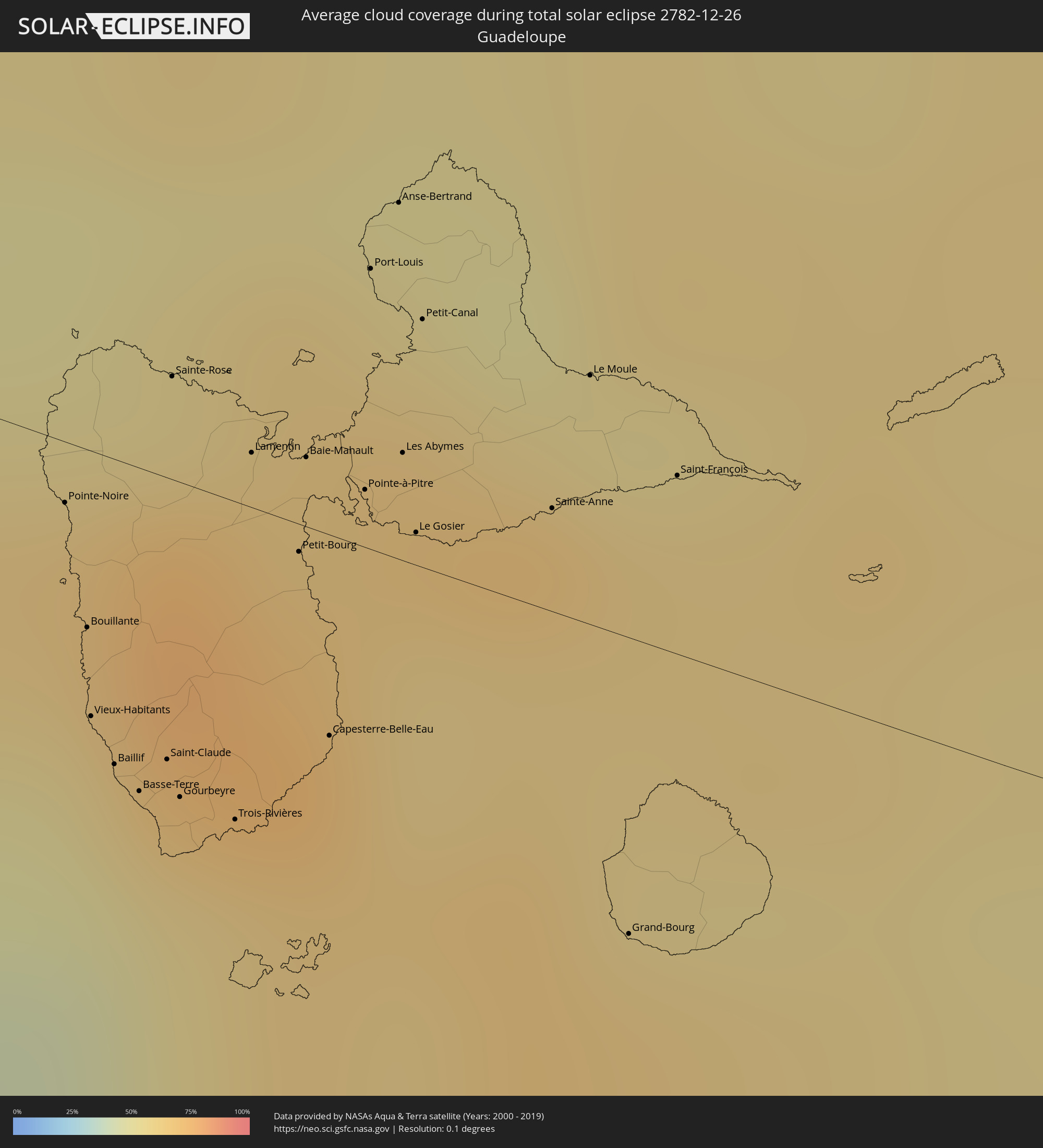 Guadeloupe
 Dominica
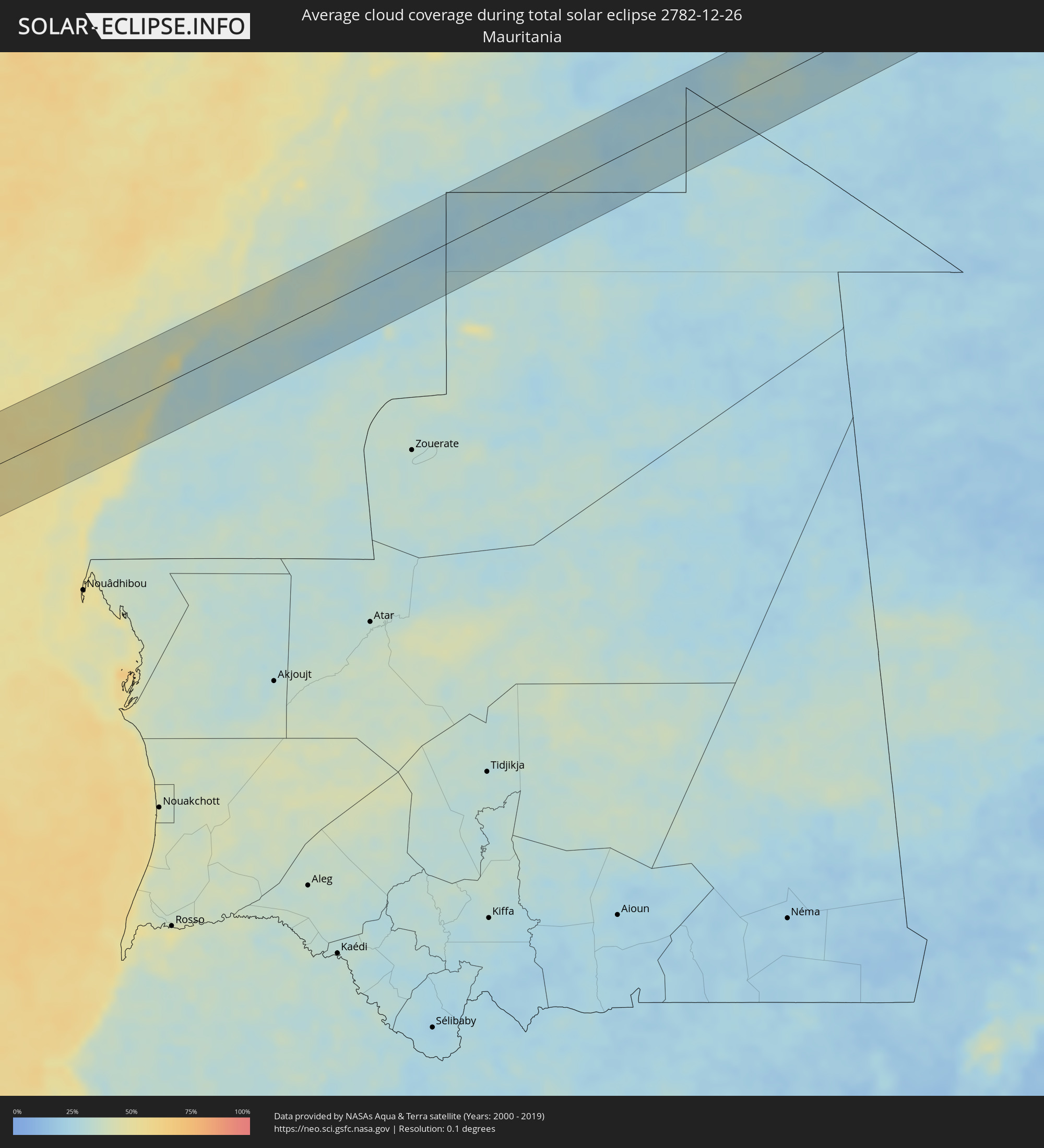 Mauretanien
 Algerien
 Besondere Gemeinde (Niederlande)
Orte im Finsternispfad
Die nachfolgene Tabelle zeigt Städte und Orte mit mehr als 5.000 Einwohnern, die sich im Finsternispfad befinden. Städte mit mehr als 100.000 Einwohnern sind dick gekennzeichnet. Mit einem Klick auf den Ort öffnet sich eine Detailkarte die die Lage des jeweiligen Ortes zusammen mit dem Verlauf der zentralen Finsternis präsentiert.
| Ort | Typ | Dauer der Verfinsterung | Ortszeit bei maximaler Verfinsterung | Entfernung zur Zentrallinie | Ø Bewölkung |
|
Wichita Falls, Texas
|
total | - | 08:16:37 UTC-06:00 | 30 km | 65% |
|
Lawton, Oklahoma
|
total | - | 08:17:10 UTC-06:00 | 42 km | 71% |
|
Denton, Texas
|
total | - | 08:16:59 UTC-06:00 | 33 km | 69% |
|
Flower Mound, Texas
|
total | - | 08:16:53 UTC-06:00 | 50 km | 69% |
|
Carrollton, Texas
|
total | - | 08:16:58 UTC-06:00 | 46 km | 73% |
|
Frisco, Texas
|
total | - | 08:17:09 UTC-06:00 | 24 km | 71% |
|
Dallas, Texas
|
total | - | 08:16:55 UTC-06:00 | 59 km | 68% |
|
Plano, Texas
|
total | - | 08:17:09 UTC-06:00 | 31 km | 70% |
|
McKinney, Texas
|
total | - | 08:17:19 UTC-06:00 | 10 km | 67% |
|
Mesquite, Texas
|
total | - | 08:17:03 UTC-06:00 | 50 km | 68% |
|
Tyler, Texas
|
total | - | 08:17:41 UTC-06:00 | 28 km | 66% |
|
Longview, Texas
|
total | - | 08:18:11 UTC-06:00 | 13 km | 67% |
|
Baton Rouge, Louisiana
|
total | - | 08:19:55 UTC-06:00 | 8 km | 71% |
|
Kenner, Louisiana
|
total | - | 08:20:31 UTC-06:00 | 7 km | 69% |
|
New Orleans, Louisiana
|
total | - | 08:20:39 UTC-06:00 | 3 km | 69% |
|
Duncan Town, Ragged Island
|
total | - | 09:37:25 UTC-05:00 | 26 km | 48% |
|
Matthew Town, Inagua
|
total | - | 09:41:08 UTC-05:00 | 46 km | 48% |
|
Mao, Valverde
|
total | - | 10:46:23 UTC-04:00 | 60 km | 44% |
|
Villa Bisonó, Santiago
|
total | - | 10:46:48 UTC-04:00 | 49 km | 54% |
|
Santiago de los Caballeros, Santiago
|
total | - | 10:47:12 UTC-04:00 | 52 km | 58% |
|
Puerto Plata, Puerto Plata
|
total | - | 10:47:12 UTC-04:00 | 17 km | 60% |
|
Concepción de La Vega, La Vega
|
total | - | 10:47:34 UTC-04:00 | 67 km | 57% |
|
Moca, Espaillat
|
total | - | 10:47:34 UTC-04:00 | 49 km | 64% |
|
San Francisco de Macorís, Duarte
|
total | - | 10:48:10 UTC-04:00 | 46 km | 65% |
|
Cotuí, Sánchez Ramírez
|
total | - | 10:48:24 UTC-04:00 | 66 km | 66% |
|
Nagua, María Trinidad Sánchez
|
total | - | 10:49:02 UTC-04:00 | 19 km | 57% |
|
Bayaguana, Monte Plata
|
total | - | 10:49:33 UTC-04:00 | 72 km | 68% |
|
Hato Mayor del Rey, Hato Mayor
|
total | - | 10:50:24 UTC-04:00 | 54 km | 66% |
|
Santa Cruz de El Seibo, El Seíbo
|
total | - | 10:50:53 UTC-04:00 | 43 km | 67% |
|
La Romana, La Romana
|
total | - | 10:51:04 UTC-04:00 | 74 km | 55% |
|
Salvaleón de Higüey, La Altagracia
|
total | - | 10:51:39 UTC-04:00 | 43 km | 73% |
|
Punta Cana, La Altagracia
|
total | - | 10:52:21 UTC-04:00 | 33 km | 62% |
|
Aguadilla, Aguadilla
|
total | - | 10:55:18 UTC-04:00 | 7 km | 49% |
|
Mayagüez, Mayaguez
|
total | - | 10:55:22 UTC-04:00 | 15 km | 54% |
|
Isabela, Isabela
|
total | - | 10:55:37 UTC-04:00 | 20 km | 50% |
|
Yauco, Yauco
|
total | - | 10:56:05 UTC-04:00 | 20 km | 41% |
|
Arecibo, Arecibo
|
total | - | 10:56:21 UTC-04:00 | 30 km | 56% |
|
Ponce, Ponce
|
total | - | 10:56:40 UTC-04:00 | 12 km | 41% |
|
Barceloneta, Barceloneta
|
total | - | 10:56:47 UTC-04:00 | 36 km | 58% |
|
Vega Baja, Vega Baja
|
total | - | 10:57:09 UTC-04:00 | 42 km | 71% |
|
Cayey, Cayey
|
total | - | 10:57:45 UTC-04:00 | 17 km | 70% |
|
Guayama, Guayama
|
total | - | 10:57:53 UTC-04:00 | 7 km | 53% |
|
San Juan, San Juan
|
total | - | 10:57:51 UTC-04:00 | 56 km | 57% |
|
Caguas, Caguas
|
total | - | 10:58:01 UTC-04:00 | 35 km | 78% |
|
Carolina, Carolina
|
total | - | 10:58:13 UTC-04:00 | 54 km | 71% |
|
Humacao, Humacao
|
total | - | 10:58:34 UTC-04:00 | 36 km | 56% |
|
Fajardo, Fajardo
|
total | - | 10:58:59 UTC-04:00 | 61 km | 70% |
|
Saint Croix, Saint Croix Island
|
total | - | 11:01:21 UTC-04:00 | 37 km | 58% |
") Oranjestad, Sint Eustatius
Oranjestad, Sint Eustatius
|
total | - | 11:06:00 UTC-04:00 | 82 km | 54% |
|
Sandy Point Town, Saint Anne Sandy Point
|
total | - | 11:06:23 UTC-04:00 | 74 km | 60% |
|
Saint Paul’s, Saint Paul Capesterre
|
total | - | 11:06:28 UTC-04:00 | 79 km | 60% |
|
Middle Island, Saint Thomas Middle Island
|
total | - | 11:06:29 UTC-04:00 | 71 km | 55% |
|
Dieppe Bay Town, Saint John Capesterre
|
total | - | 11:06:28 UTC-04:00 | 81 km | 60% |
|
Trinity, Trinity Palmetto Point
|
total | - | 11:06:37 UTC-04:00 | 71 km | 55% |
|
Nicola Town, Christ Church Nichola Town
|
total | - | 11:06:39 UTC-04:00 | 78 km | 60% |
|
Cayon, Saint Mary Cayon
|
total | - | 11:06:42 UTC-04:00 | 77 km | 55% |
|
Basseterre, Saint George Basseterre
|
total | - | 11:06:44 UTC-04:00 | 72 km | 61% |
|
Monkey Hill, Saint Peter Basseterre
|
total | - | 11:06:45 UTC-04:00 | 74 km | 61% |
|
Charlestown, Saint Paul Charlestown
|
total | - | 11:07:03 UTC-04:00 | 59 km | 51% |
|
Cotton Ground, Saint Thomas Lowland
|
total | - | 11:07:03 UTC-04:00 | 63 km | 52% |
|
Fig Tree, Saint John Figtree
|
total | - | 11:07:06 UTC-04:00 | 58 km | 51% |
|
Newcastle, Saint James Windwa
|
total | - | 11:07:08 UTC-04:00 | 67 km | 52% |
|
Market Shop, Saint George Gingerland
|
total | - | 11:07:12 UTC-04:00 | 59 km | 51% |
|
Saint Peters, Saint Peter
|
total | - | 11:08:13 UTC-04:00 | 36 km | 61% |
|
Plymouth, Saint Anthony
|
total | - | 11:08:14 UTC-04:00 | 29 km | 60% |
|
Brades, Saint Peter
|
total | - | 11:08:13 UTC-04:00 | 38 km | 61% |
|
Bolands, Saint Mary
|
total | - | 11:09:05 UTC-04:00 | 79 km | 60% |
|
Saint John’s, Saint John
|
total | - | 11:09:09 UTC-04:00 | 86 km | 58% |
|
Piggotts, Saint George
|
total | - | 11:09:17 UTC-04:00 | 87 km | 58% |
|
Pointe-Noire, Guadeloupe
|
total | - | 11:09:30 UTC-04:00 | 5 km | 62% |
|
Falmouth, Saint Paul
|
total | - | 11:09:21 UTC-04:00 | 79 km | 55% |
|
Parham, Saint Peter
|
total | - | 11:09:22 UTC-04:00 | 86 km | 58% |
|
Bouillante, Guadeloupe
|
total | - | 11:09:34 UTC-04:00 | 15 km | 54% |
|
Vieux-Habitants, Guadeloupe
|
total | - | 11:09:36 UTC-04:00 | 22 km | 54% |
|
Basse-Terre, Guadeloupe
|
total | - | 11:09:43 UTC-04:00 | 27 km | 58% |
|
Saint-Claude, Guadeloupe
|
total | - | 11:09:47 UTC-04:00 | 24 km | 58% |
|
Sainte-Rose, Guadeloupe
|
total | - | 11:09:43 UTC-04:00 | 9 km | 72% |
|
Gourbeyre, Guadeloupe
|
total | - | 11:09:49 UTC-04:00 | 27 km | 58% |
|
Trois-Rivières, Guadeloupe
|
total | - | 11:09:57 UTC-04:00 | 27 km | 64% |
|
Lamentin, Guadeloupe
|
total | - | 11:09:55 UTC-04:00 | 5 km | 64% |
|
Capesterre-Belle-Eau, Guadeloupe
|
total | - | 11:10:09 UTC-04:00 | 17 km | 64% |
|
Les Abymes, Guadeloupe
|
total | - | 11:10:16 UTC-04:00 | 9 km | 65% |
|
Petit-Canal, Guadeloupe
|
total | - | 11:10:18 UTC-04:00 | 21 km | 63% |
|
Portsmouth, Saint John
|
total | - | 11:10:32 UTC-04:00 | 62 km | 63% |
|
Colihaut, Saint Peter
|
total | - | 11:10:34 UTC-04:00 | 72 km | 61% |
|
Saint Joseph, Saint Joseph
|
total | - | 11:10:40 UTC-04:00 | 80 km | 66% |
|
Pont Cassé, Saint Paul
|
total | - | 11:10:55 UTC-04:00 | 81 km | 66% |
|
Le Moule, Guadeloupe
|
total | - | 11:10:42 UTC-04:00 | 21 km | 61% |
|
Wesley, Saint Andrew
|
total | - | 11:10:57 UTC-04:00 | 59 km | 70% |
|
Grand-Bourg, Guadeloupe
|
total | - | 11:10:53 UTC-04:00 | 25 km | 62% |
|
Saint-François, Guadeloupe
|
total | - | 11:10:55 UTC-04:00 | 15 km | 61% |
|
Rosalie, Saint David
|
total | - | 11:11:09 UTC-04:00 | 78 km | 83% |
 Dakhla, Oued Ed-Dahab-Lagouira
|
total | - | 17:53:50 UTC+01:00 | 13 km | 43% |
|
Gueltat Zemmour, Laâyoune-Boujdour-Sakia El Hamra
|
total | - | 17:56:21 UTC+01:00 | 4 km | 26% |
|
Tindouf, Tindouf
|
total | - | 17:57:51 UTC+01:00 | 56 km | 26% |