Totale Sonnenfinsternis vom 26.05.2989
| Wochentag: | Dienstag |
| Maximale Dauer der Verfinsterung: | 05m00s |
| Maximale Breite des Finsternispfades: | 179 km |
| Saroszyklus: | 163 |
| Bedeckungsgrad: | 100% |
| Magnitude: | 1.0525 |
| Gamma: | -0.2555 |
Wo kann man die Sonnenfinsternis vom 26.05.2989 sehen?
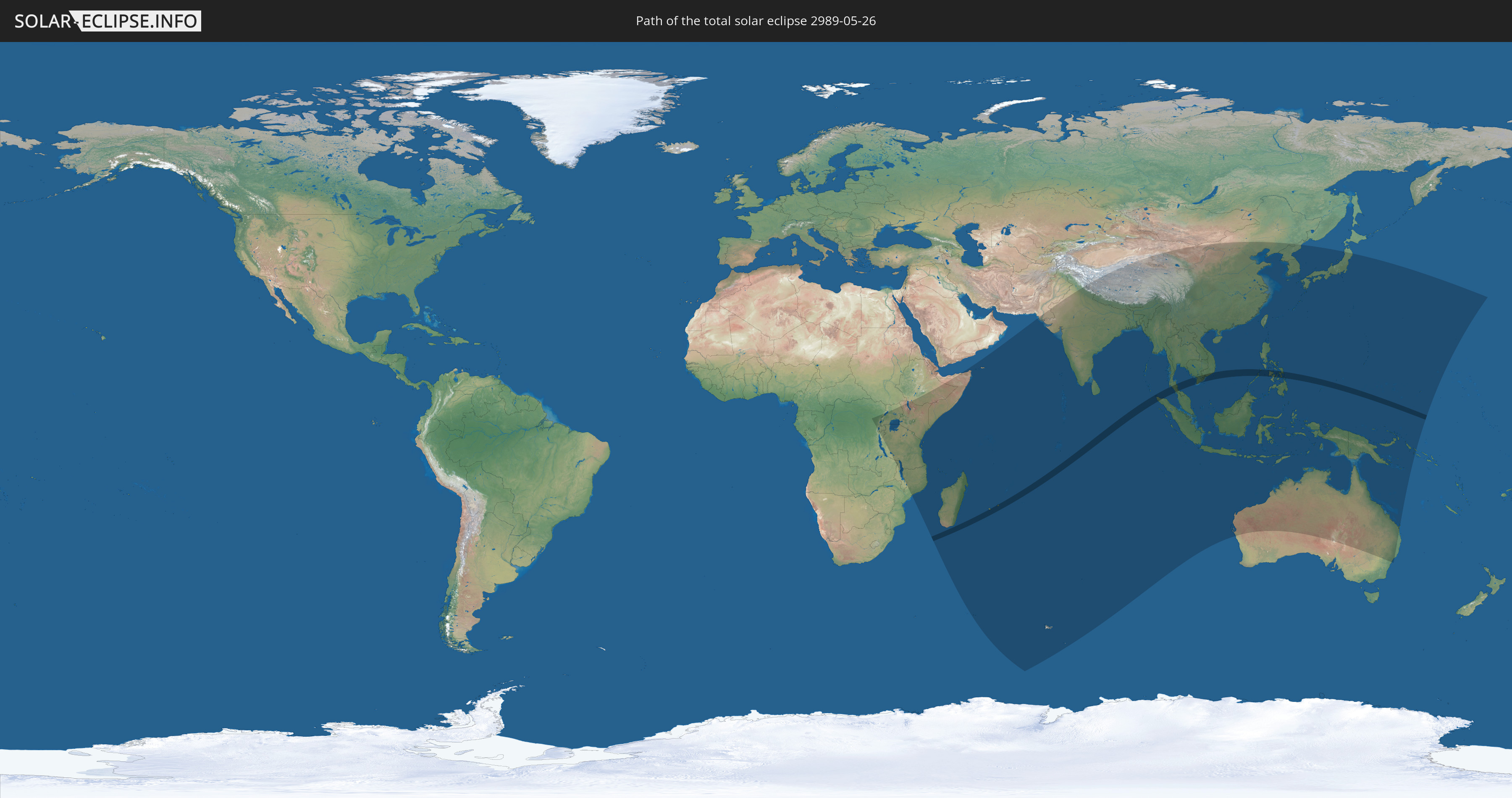
Die Sonnenfinsternis am 26.05.2989 kann man in 57 Ländern als partielle Sonnenfinsternis beobachten.
Der Finsternispfad verläuft durch 6 Länder. Nur in diesen Ländern ist sie als totale Sonnenfinsternis zu sehen.
In den folgenden Ländern ist die Sonnenfinsternis total zu sehen
 Réunion
 Mauritius
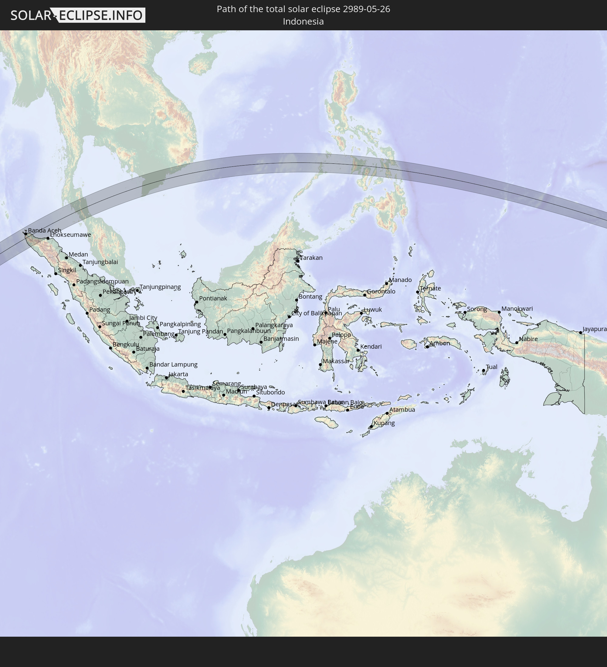 Indonesien
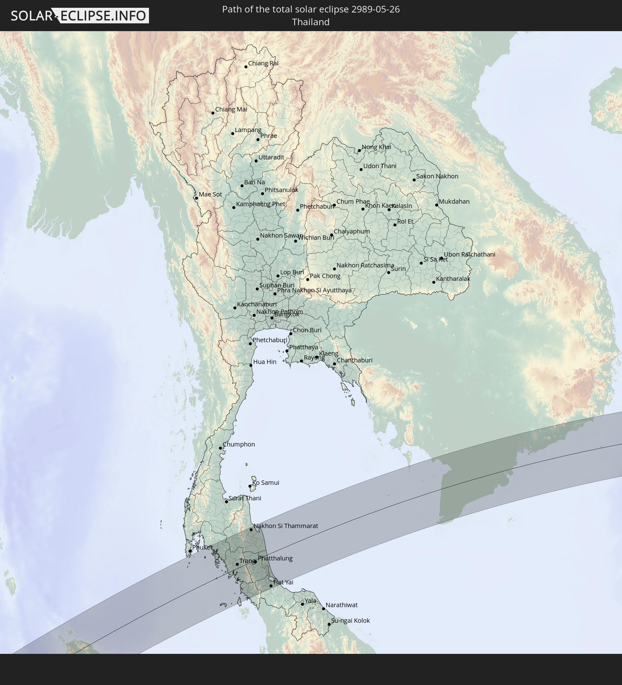 Thailand
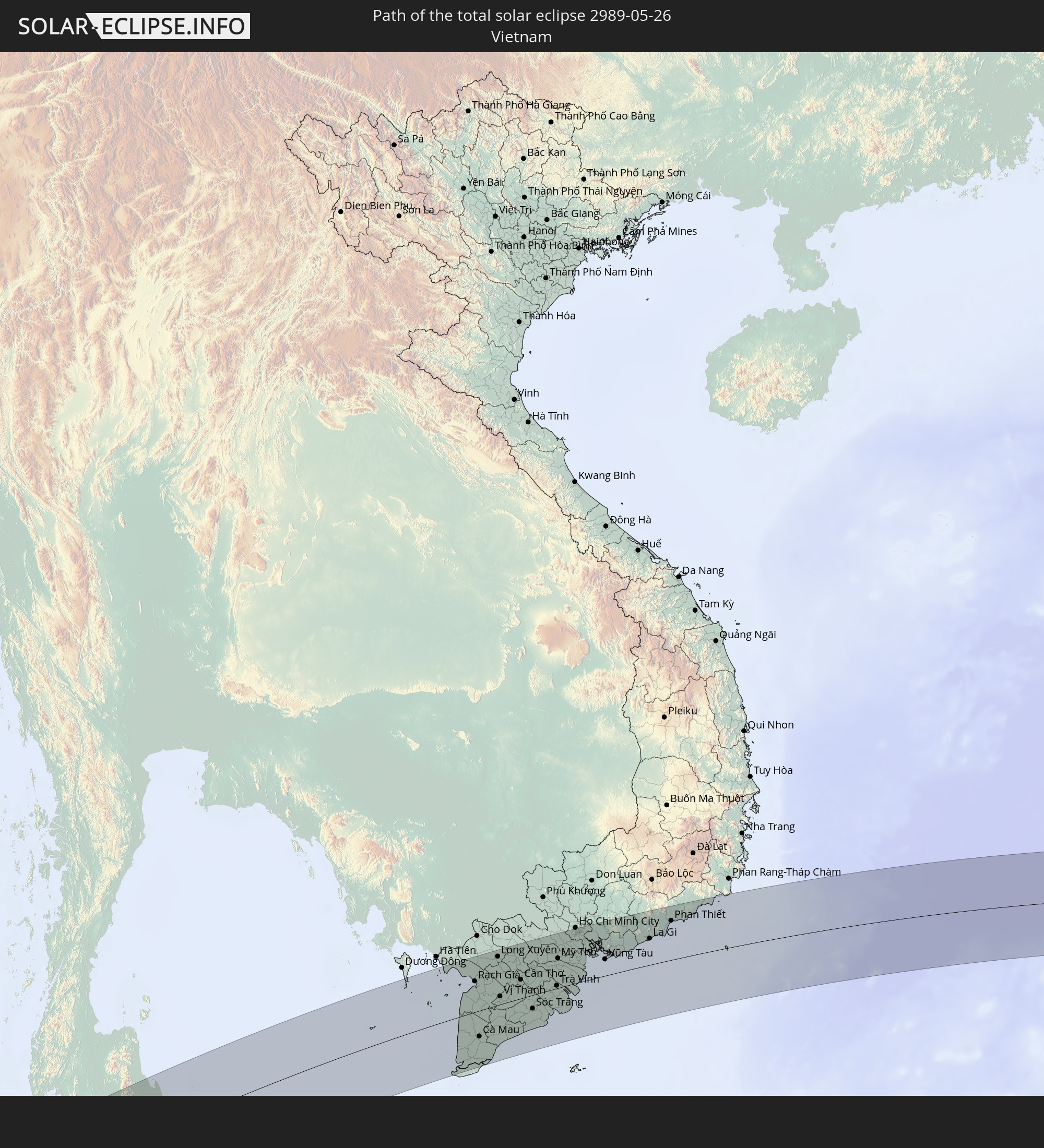 Vietnam
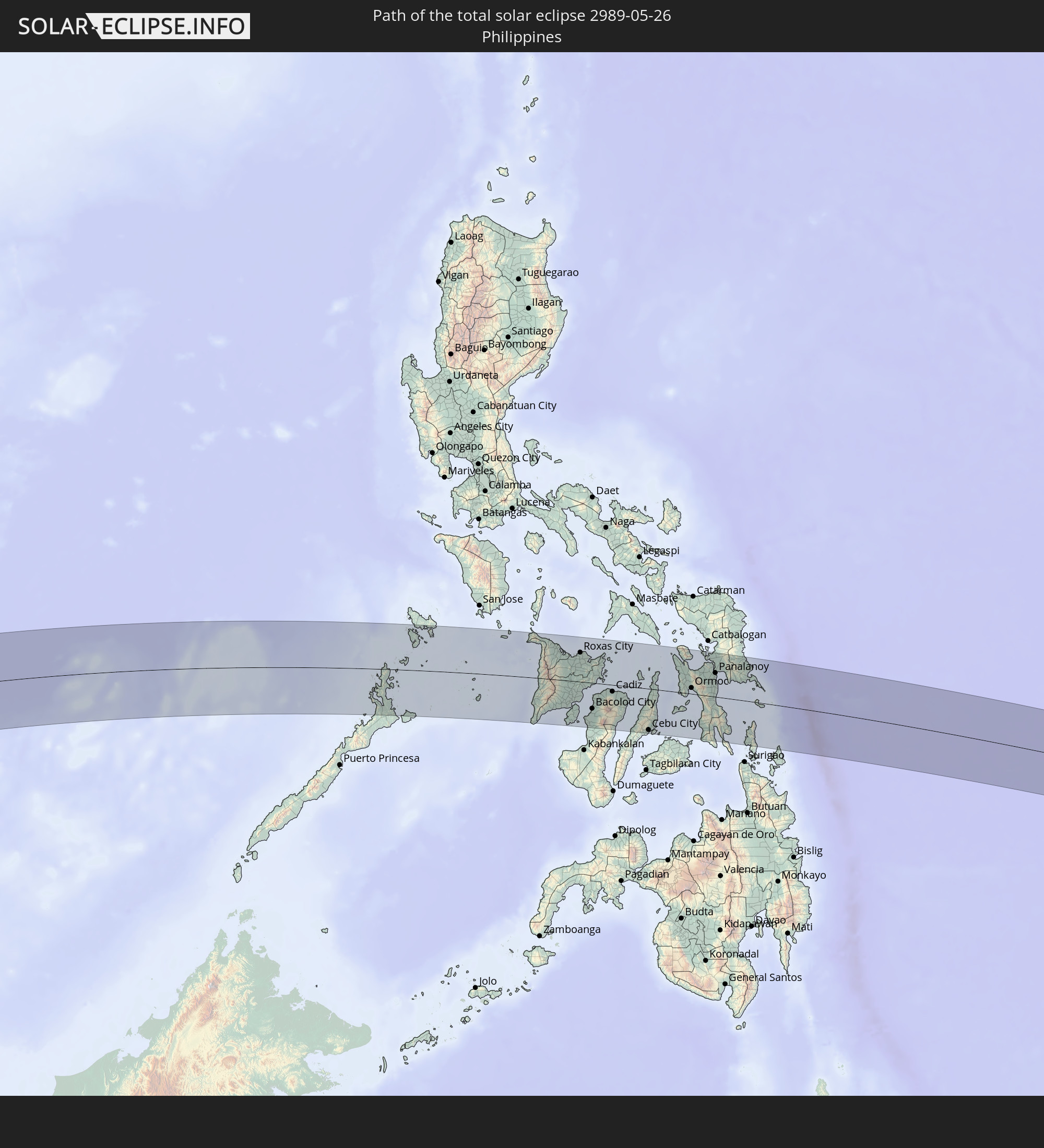 Philippinen
In den folgenden Ländern ist die Sonnenfinsternis partiell zu sehen
 United States Minor Outlying Islands
 Demokratische Republik Kongo
 Sambia
 Ruanda
 Burundi
 Tansania
 Uganda
 Mosambik
 Malawi
 Äthiopien
 Kenia
Kenia
 Französische Süd- und Antarktisgebiete
 Somalia
 Jemen
Jemen
 Madagaskar
 Komoren
 Mayotte
 Seychellen
 Réunion
 Mauritius
 Pakistan
 Indien
 Britisches Territorium im Indischen Ozean
 Heard und McDonaldinseln
 Malediven
 Volksrepublik China
 Sri Lanka
 Nepal
Nepal
 Bangladesch
 Bhutan
 Myanmar
 Indonesien
 Kokosinseln
 Thailand
 Malaysia
 Laos
Laos
 Vietnam
 Kambodscha
 Singapur
 Weihnachtsinsel
 Australien
 Macau
Macau
 Hongkong
 Brunei
 Taiwan
 Philippinen
 Japan
Japan
 Osttimor
 Nordkorea
 Südkorea
 Palau
Palau
 Föderierte Staaten von Mikronesien
 Papua-Neuguinea
 Guam
Guam
 Nördliche Marianen
 Salomonen
 Marshallinseln
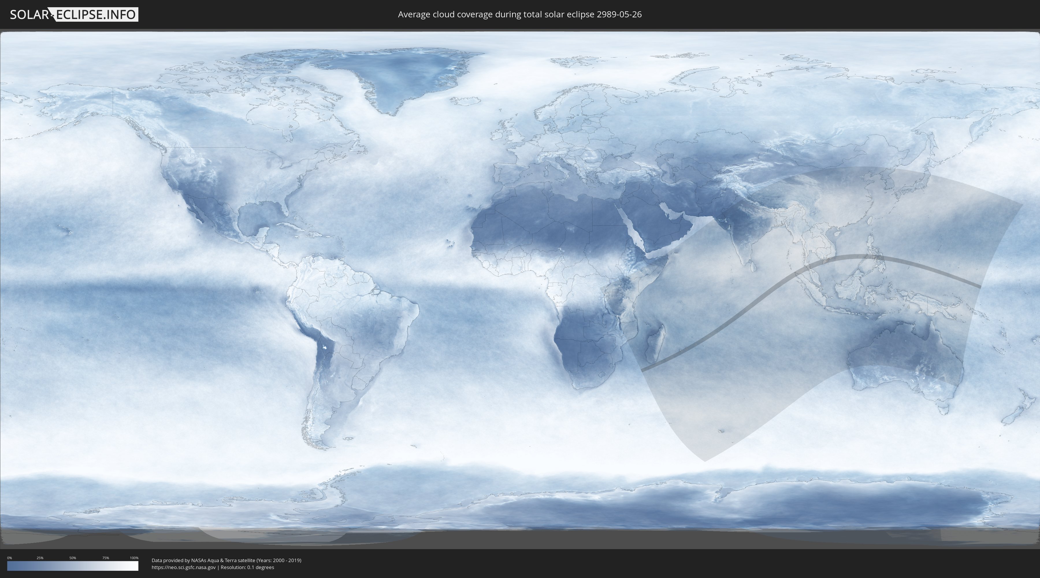
Wie wird das Wetter während der totalen Sonnenfinsternis am 26.05.2989?
Wo ist der beste Ort, um die totale Sonnenfinsternis vom 26.05.2989 zu beobachten?
Die folgenden Karten zeigen die durchschnittliche Bewölkung für den Tag, an dem die totale Sonnenfinsternis
stattfindet. Mit Hilfe der Karten lässt sich der Ort entlang des Finsternispfades eingrenzen,
der die besten Aussichen auf einen klaren wolkenfreien Himmel bietet.
Trotzdem muss man immer lokale Gegenenheiten beachten und sollte sich genau über das Wetter an seinem
gewählten Beobachtungsort informieren.
Die Daten stammen von den beiden NASA-Satelliten
AQUA und TERRA
und wurden über einen Zeitraum von 19 Jahren (2000 - 2019) gemittelt.

Detaillierte Länderkarten
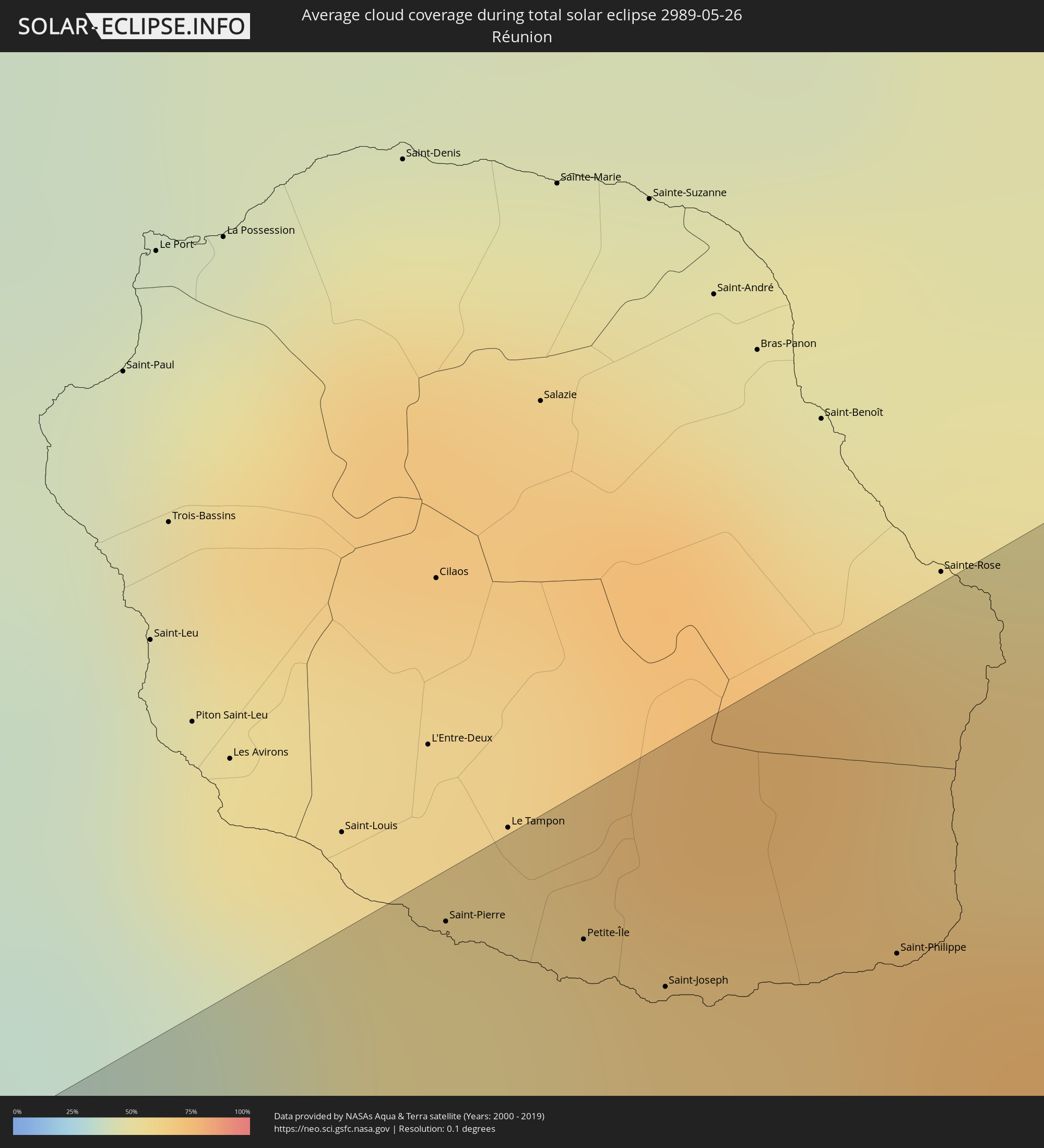 Réunion
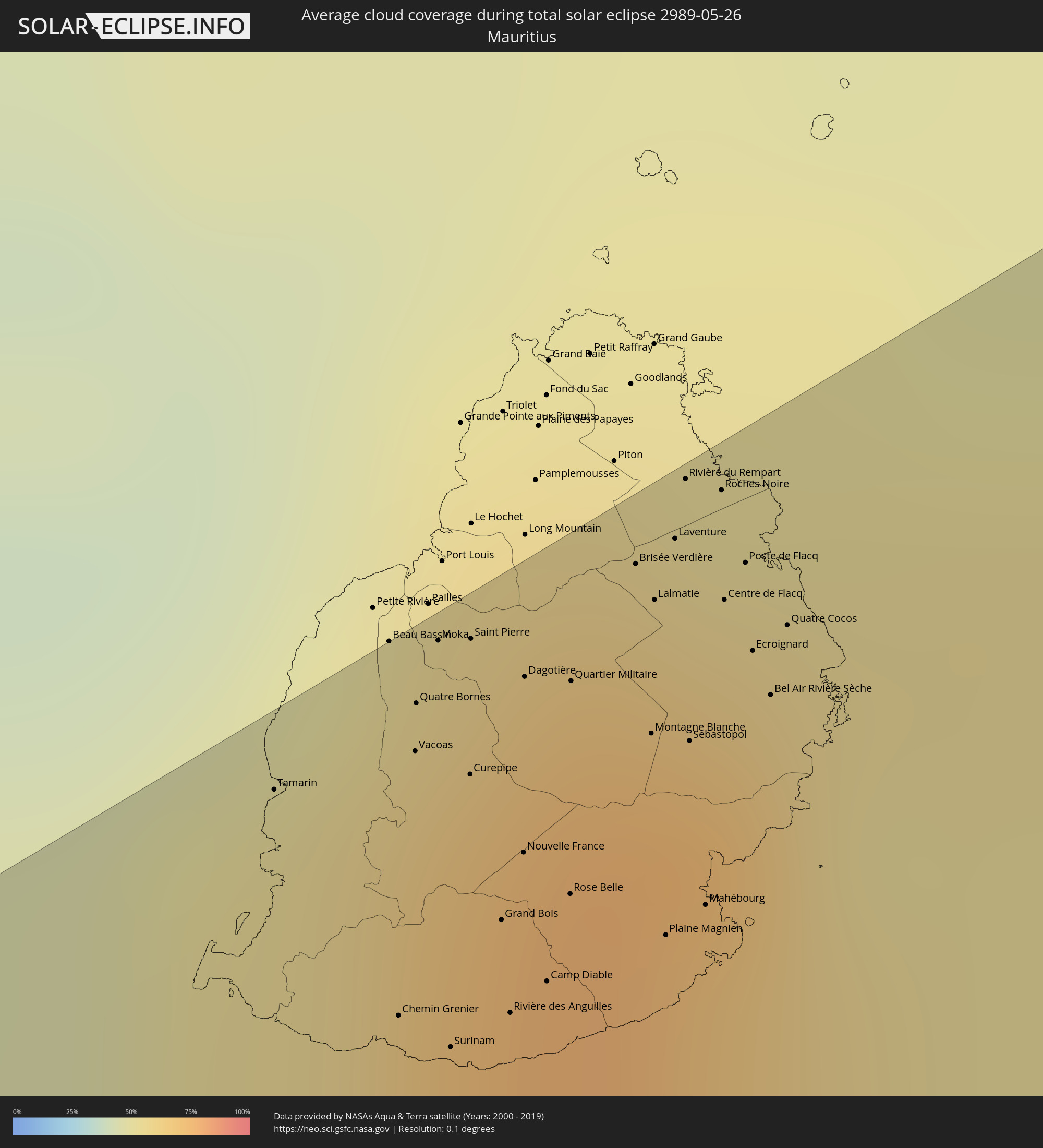 Mauritius
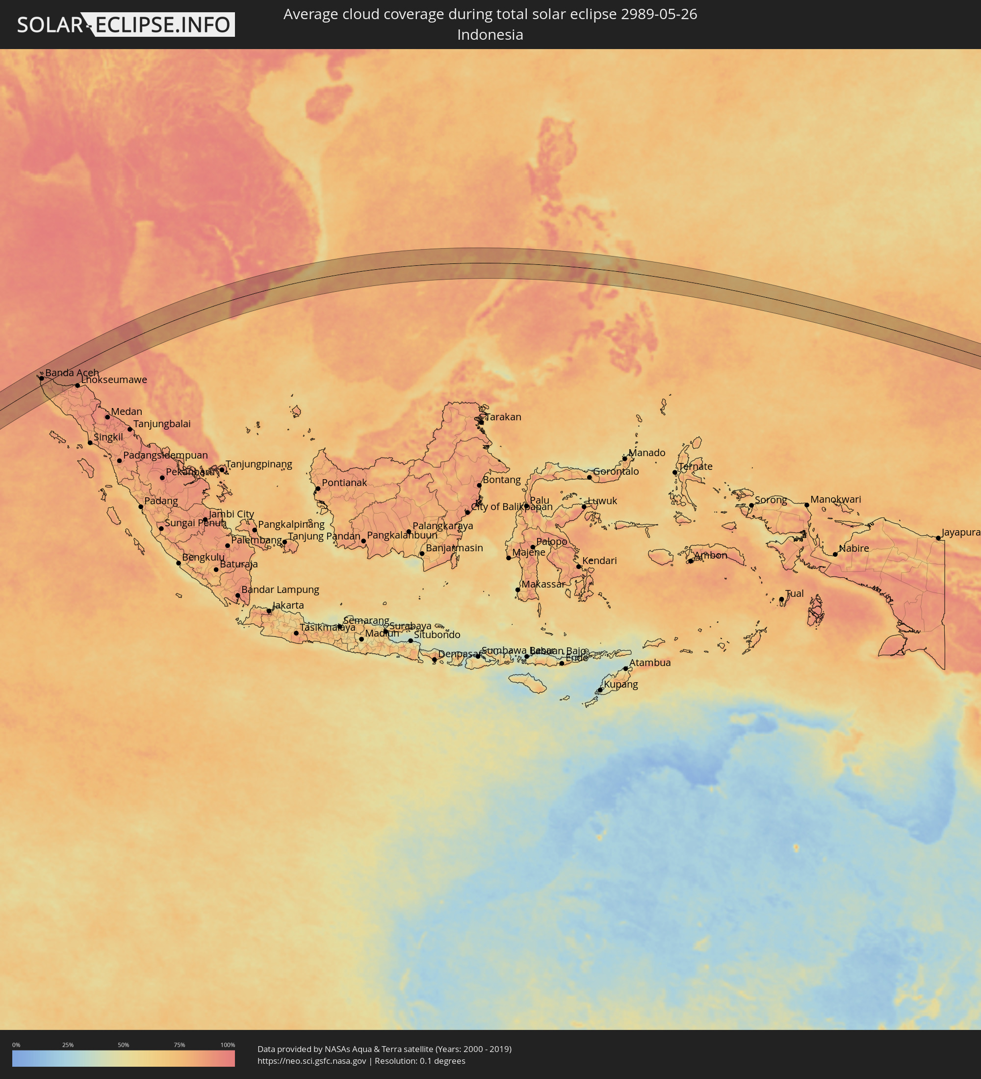 Indonesien
 Thailand
 Vietnam
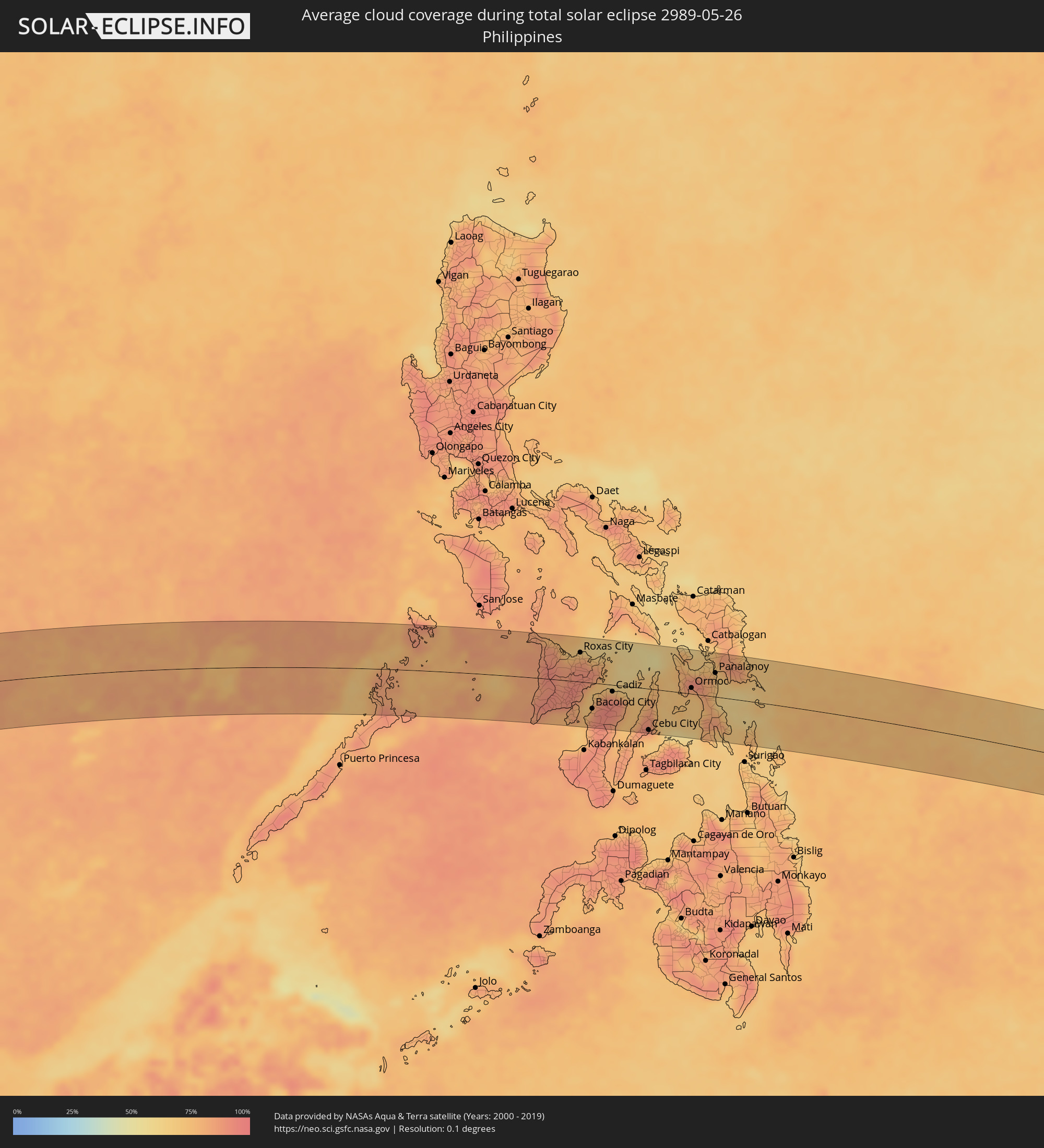 Philippinen
Orte im Finsternispfad
Die nachfolgene Tabelle zeigt Städte und Orte mit mehr als 5.000 Einwohnern, die sich im Finsternispfad befinden. Städte mit mehr als 100.000 Einwohnern sind dick gekennzeichnet. Mit einem Klick auf den Ort öffnet sich eine Detailkarte die die Lage des jeweiligen Ortes zusammen mit dem Verlauf der zentralen Finsternis präsentiert.
| Ort | Typ | Dauer der Verfinsterung | Ortszeit bei maximaler Verfinsterung | Entfernung zur Zentrallinie | Ø Bewölkung |
|
Saint-Pierre, Réunion
|
total | - | 08:02:33 UTC+04:00 | 64 km | 50% |
|
Petite-Île, Réunion
|
total | - | 08:02:35 UTC+04:00 | 59 km | 57% |
|
Saint-Joseph, Réunion
|
total | - | 08:02:36 UTC+04:00 | 53 km | 57% |
|
Saint-Philippe, Réunion
|
total | - | 08:02:41 UTC+04:00 | 48 km | 61% |
|
Tamarin, Black River
|
total | - | 08:03:44 UTC+04:00 | 63 km | 57% |
|
Beau Bassin, Plaines Wilhems
|
total | - | 08:03:49 UTC+04:00 | 68 km | 67% |
|
Chemin Grenier, Savanne
|
total | - | 08:03:45 UTC+04:00 | 42 km | 55% |
|
Vacoas, Plaines Wilhems
|
total | - | 08:03:48 UTC+04:00 | 60 km | 70% |
|
Quatre Bornes, Plaines Wilhems
|
total | - | 08:03:49 UTC+04:00 | 63 km | 70% |
|
Moka, Moka
|
total | - | 08:03:50 UTC+04:00 | 67 km | 67% |
|
Surinam, Savanne
|
total | - | 08:03:46 UTC+04:00 | 38 km | 55% |
|
Souillac, Savanne
|
total | - | 08:03:46 UTC+04:00 | 37 km | 55% |
|
Curepipe, Plaines Wilhems
|
total | - | 08:03:49 UTC+04:00 | 56 km | 70% |
|
Saint Pierre, Moka
|
total | - | 08:03:51 UTC+04:00 | 65 km | 67% |
|
Grand Bois, Savanne
|
total | - | 08:03:49 UTC+04:00 | 45 km | 69% |
|
Rivière des Anguilles, Savanne
|
total | - | 08:03:48 UTC+04:00 | 38 km | 55% |
|
Nouvelle France, Grand Port
|
total | - | 08:03:50 UTC+04:00 | 49 km | 70% |
|
Dagotière, Moka
|
total | - | 08:03:52 UTC+04:00 | 61 km | 75% |
|
Camp Diable, Savanne
|
total | - | 08:03:49 UTC+04:00 | 39 km | 55% |
|
Rose Belle, Grand Port
|
total | - | 08:03:51 UTC+04:00 | 44 km | 70% |
|
Quartier Militaire, Moka
|
total | - | 08:03:53 UTC+04:00 | 58 km | 75% |
|
New Grove, Grand Port
|
total | - | 08:03:51 UTC+04:00 | 42 km | 70% |
|
Brisée Verdière, Flacq
|
total | - | 08:03:56 UTC+04:00 | 64 km | 75% |
|
Bon Accueil, Flacq
|
total | - | 08:03:56 UTC+04:00 | 63 km | 73% |
|
Montagne Blanche
|
total | - | 08:03:54 UTC+04:00 | 52 km | 68% |
|
Lalmatie, Flacq
|
total | - | 08:03:56 UTC+04:00 | 61 km | 73% |
|
Plaine Magnien, Grand Port
|
total | - | 08:03:53 UTC+04:00 | 37 km | 58% |
|
Laventure, Flacq
|
total | - | 08:03:57 UTC+04:00 | 64 km | 62% |
|
Rivière du Rempart, Rivière du Rempart
|
total | - | 08:03:58 UTC+04:00 | 68 km | 62% |
|
Sebastopol, Flacq
|
total | - | 08:03:55 UTC+04:00 | 49 km | 68% |
|
Beau Vallon, Grand Port
|
total | - | 08:03:54 UTC+04:00 | 37 km | 58% |
|
Mahébourg, Grand Port
|
total | - | 08:03:54 UTC+04:00 | 38 km | 58% |
|
Roches Noire, Rivière du Rempart
|
total | - | 08:03:59 UTC+04:00 | 65 km | 62% |
|
Centre de Flacq, Flacq
|
total | - | 08:03:58 UTC+04:00 | 58 km | 73% |
|
Poste de Flacq, Flacq
|
total | - | 08:03:59 UTC+04:00 | 59 km | 73% |
|
Ecroignard, Flacq
|
total | - | 08:03:58 UTC+04:00 | 53 km | 73% |
|
Bel Air Rivière Sèche, Flacq
|
total | - | 08:03:58 UTC+04:00 | 49 km | 68% |
|
Quatre Cocos, Flacq
|
total | - | 08:03:59 UTC+04:00 | 53 km | 55% |
|
Sabang, Aceh
|
total | - | 12:29:43 UTC+07:00 | 63 km | 86% |
|
Banda Aceh, Aceh
|
total | - | 12:29:16 UTC+07:00 | 29 km | 85% |
|
Sigli, Aceh
|
total | - | 12:30:46 UTC+07:00 | 21 km | 83% |
|
Reuleuet, Aceh
|
total | - | 12:31:26 UTC+07:00 | 55 km | 87% |
|
Bireun, Aceh
|
total | - | 12:32:36 UTC+07:00 | 79 km | 88% |
|
Nuea Khlong, Krabi
|
total | - | 12:43:06 UTC+07:00 | 90 km | 91% |
|
Saladan, Krabi
|
total | - | 12:42:36 UTC+07:00 | 42 km | 87% |
|
Ko Lanta, Krabi
|
total | - | 12:42:38 UTC+07:00 | 32 km | 87% |
|
Kantang, Trang
|
total | - | 12:43:42 UTC+07:00 | 2 km | 87% |
|
Trang, Trang
|
total | - | 12:44:11 UTC+07:00 | 9 km | 94% |
|
Huai Yot, Trang
|
total | - | 12:44:34 UTC+07:00 | 32 km | 93% |
|
Thung Song, Nakhon Si Thammarat
|
total | - | 12:45:11 UTC+07:00 | 68 km | 95% |
|
Ron Phibun, Nakhon Si Thammarat
|
total | - | 12:45:42 UTC+07:00 | 61 km | 93% |
|
Nakhon Si Thammarat, Nakhon Si Thammarat
|
total | - | 12:46:21 UTC+07:00 | 82 km | 95% |
|
Phatthalung, Phatthalung
|
total | - | 12:45:37 UTC+07:00 | 6 km | 92% |
|
Pak Phanang, Nakhon Si Thammarat
|
total | - | 12:46:56 UTC+07:00 | 63 km | 89% |
|
Ranot, Songkhla
|
total | - | 12:46:32 UTC+07:00 | 1 km | 89% |
|
Hat Yai, Songkhla
|
total | - | 12:45:59 UTC+07:00 | 86 km | 91% |
|
Ban Mai, Songkhla
|
total | - | 12:46:27 UTC+07:00 | 69 km | 86% |
|
Songkhla, Songkhla
|
total | - | 12:46:35 UTC+07:00 | 72 km | 87% |
|
Rạch Giá, Kiến Giang
|
total | - | 13:03:02 UTC+07:00 | 50 km | 91% |
|
Cà Mau, Cà Mau
|
total | - | 13:02:21 UTC+07:00 | 42 km | 95% |
|
Long Xuyên, An Giang
|
total | - | 13:04:26 UTC+07:00 | 78 km | 88% |
|
Vị Thanh, Hau Giang
|
total | - | 13:03:55 UTC+07:00 | 13 km | 92% |
|
Cao Lãnh, Đồng Tháp
|
total | - | 13:05:05 UTC+07:00 | 80 km | 89% |
|
Thành phố Bạc Liêu, Bạc Liêu
|
total | - | 13:04:09 UTC+07:00 | 47 km | 93% |
|
Sadek, Đồng Tháp
|
total | - | 13:05:16 UTC+07:00 | 58 km | 93% |
|
Cần Thơ, Cần Thơ
|
total | - | 13:05:06 UTC+07:00 | 30 km | 93% |
|
Sóc Trăng, Sóc Trăng
|
total | - | 13:05:11 UTC+07:00 | 22 km | 97% |
|
Vĩnh Long, Vĩnh Long
|
total | - | 13:05:51 UTC+07:00 | 48 km | 88% |
|
Ấp Tân Ngãi, Bến Tre
|
total | - | 13:06:43 UTC+07:00 | 37 km | 89% |
|
Trà Vinh, Trà Vinh
|
total | - | 13:06:36 UTC+07:00 | 4 km | 94% |
|
Mỹ Tho, Tiền Giang
|
total | - | 13:07:04 UTC+07:00 | 48 km | 92% |
|
Bến Tre, Bến Tre
|
total | - | 13:06:59 UTC+07:00 | 35 km | 89% |
|
Tân An, Long An
|
total | - | 13:07:23 UTC+07:00 | 66 km | 95% |
|
Cần Giuộc, Long An
|
total | - | 13:08:12 UTC+07:00 | 66 km | 94% |
|
Cần Giờ, Ho Chi Minh City
|
total | - | 13:08:49 UTC+07:00 | 37 km | 73% |
|
Vũng Tàu, Bà Rịa-Vũng Tàu
|
total | - | 13:09:07 UTC+07:00 | 27 km | 73% |
|
Thành Phố Bà Rịa, Bà Rịa-Vũng Tàu
|
total | - | 13:09:30 UTC+07:00 | 41 km | 88% |
|
La Gi, Bình Thuận
|
total | - | 13:11:22 UTC+07:00 | 43 km | 82% |
|
Phan Thiết, Bình Thuận
|
total | - | 13:12:32 UTC+07:00 | 64 km | 79% |
|
Pandan, Western Visayas
|
total | - | 14:47:37 UTC+08:00 | 64 km | 85% |
|
Kalibo (poblacion), Western Visayas
|
total | - | 14:48:09 UTC+08:00 | 63 km | 76% |
|
Tigbauan, Western Visayas
|
total | - | 14:47:55 UTC+08:00 | 52 km | 80% |
|
Janiuay, Western Visayas
|
total | - | 14:48:15 UTC+08:00 | 20 km | 91% |
|
Iloilo, Western Visayas
|
total | - | 14:48:19 UTC+08:00 | 47 km | 83% |
|
Passi, Western Visayas
|
total | - | 14:48:34 UTC+08:00 | 1 km | 94% |
|
Barotac Nuevo, Western Visayas
|
total | - | 14:48:39 UTC+08:00 | 24 km | 84% |
|
Roxas City, Western Visayas
|
total | - | 14:48:54 UTC+08:00 | 53 km | 82% |
|
Bago City, Western Visayas
|
total | - | 14:48:49 UTC+08:00 | 63 km | 76% |
|
La Carlota, Western Visayas
|
total | - | 14:48:58 UTC+08:00 | 74 km | 83% |
|
Bacolod City, Western Visayas
|
total | - | 14:49:05 UTC+08:00 | 47 km | 90% |
|
Victorias, Western Visayas
|
total | - | 14:49:23 UTC+08:00 | 20 km | 87% |
|
Estancia, Western Visayas
|
total | - | 14:49:40 UTC+08:00 | 43 km | 71% |
|
Canlaon, Central Visayas
|
total | - | 14:49:34 UTC+08:00 | 75 km | 87% |
|
Cadiz, Western Visayas
|
total | - | 14:49:49 UTC+08:00 | 12 km | 90% |
|
Ualog, Western Visayas
|
total | - | 14:49:57 UTC+08:00 | 52 km | 80% |
|
Escalante, Western Visayas
|
total | - | 14:50:13 UTC+08:00 | 22 km | 77% |
|
Toledo, Central Visayas
|
total | - | 14:50:23 UTC+08:00 | 71 km | 78% |
|
Balamban, Central Visayas
|
total | - | 14:50:34 UTC+08:00 | 56 km | 82% |
|
Bantayan, Central Visayas
|
total | - | 14:50:43 UTC+08:00 | 17 km | 69% |
|
Cebu City, Central Visayas
|
total | - | 14:50:52 UTC+08:00 | 75 km | 78% |
|
Bogo, Central Visayas
|
total | - | 14:51:15 UTC+08:00 | 8 km | 76% |
|
Daanbantayan, Central Visayas
|
total | - | 14:51:18 UTC+08:00 | 30 km | 73% |
|
Danao, Central Visayas
|
total | - | 14:51:11 UTC+08:00 | 51 km | 73% |
|
Palompon, Eastern Visayas
|
total | - | 14:51:58 UTC+08:00 | 13 km | 77% |
|
Naval, Eastern Visayas
|
total | - | 14:52:05 UTC+08:00 | 69 km | 72% |
|
Ormoc, Eastern Visayas
|
total | - | 14:52:23 UTC+08:00 | 11 km | 73% |
|
Carigara, Eastern Visayas
|
total | - | 14:52:34 UTC+08:00 | 44 km | 84% |
|
Baybay, Eastern Visayas
|
total | - | 14:52:41 UTC+08:00 | 23 km | 73% |
|
Burauen, Eastern Visayas
|
total | - | 14:52:55 UTC+08:00 | 11 km | 75% |
|
Panalanoy, Eastern Visayas
|
total | - | 14:53:10 UTC+08:00 | 43 km | 71% |
|
Abuyog, Eastern Visayas
|
total | - | 14:53:05 UTC+08:00 | 13 km | 77% |
|
Tanauan, Eastern Visayas
|
total | - | 14:53:10 UTC+08:00 | 28 km | 70% |
|
Guiuan, Eastern Visayas
|
total | - | 14:54:26 UTC+08:00 | 29 km | 65% |