Totale Sonnenfinsternis vom 15.05.2990
| Wochentag: | Samstag |
| Maximale Dauer der Verfinsterung: | 04m58s |
| Maximale Breite des Finsternispfades: | 254 km |
| Saroszyklus: | 173 |
| Bedeckungsgrad: | 100% |
| Magnitude: | 1.0689 |
| Gamma: | 0.471 |
Wo kann man die Sonnenfinsternis vom 15.05.2990 sehen?
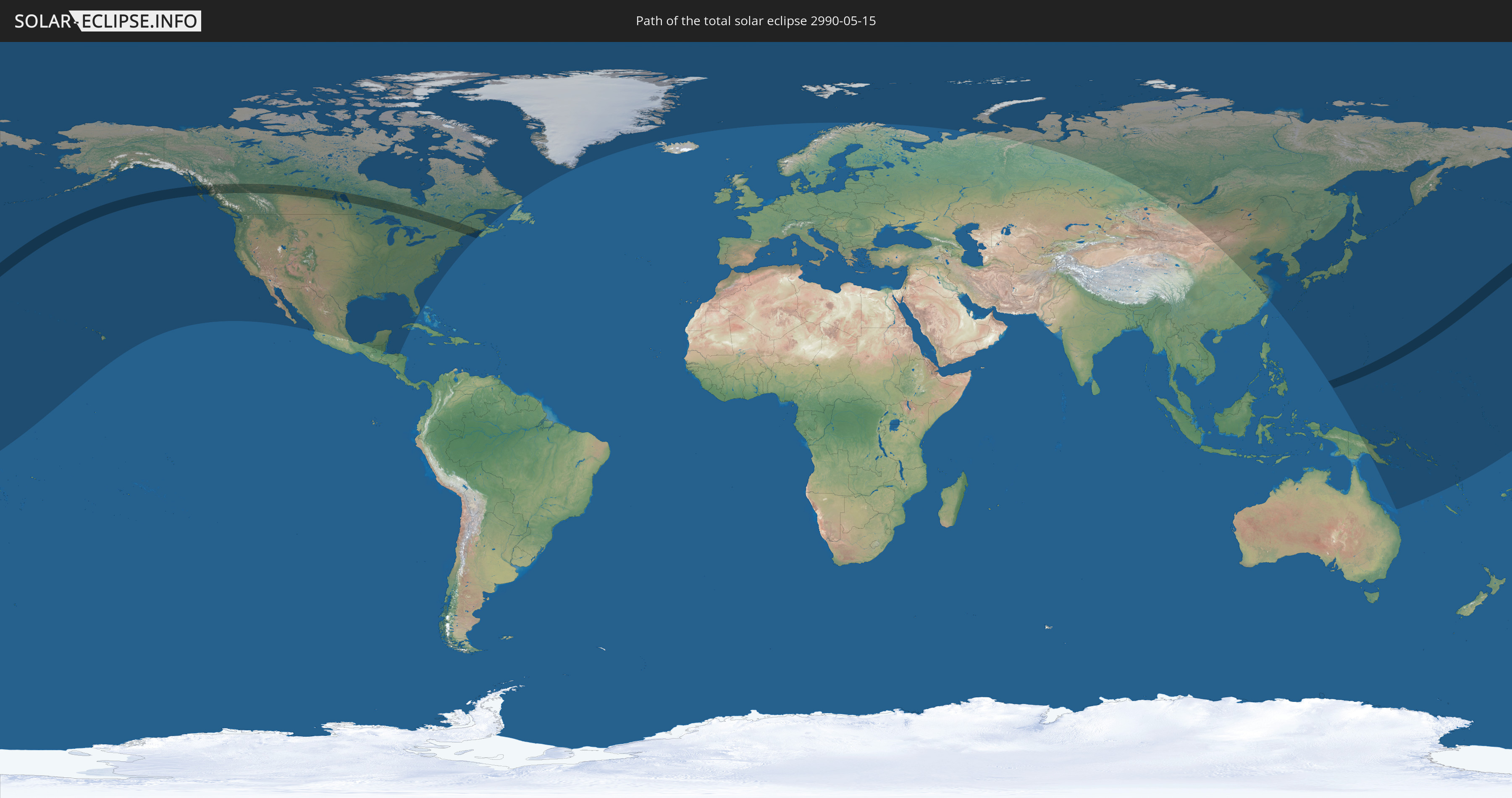
Die Sonnenfinsternis am 15.05.2990 kann man in 27 Ländern als partielle Sonnenfinsternis beobachten.
Der Finsternispfad verläuft durch 3 Länder. Nur in diesen Ländern ist sie als totale Sonnenfinsternis zu sehen.
In den folgenden Ländern ist die Sonnenfinsternis total zu sehen
 Vereinigte Staaten
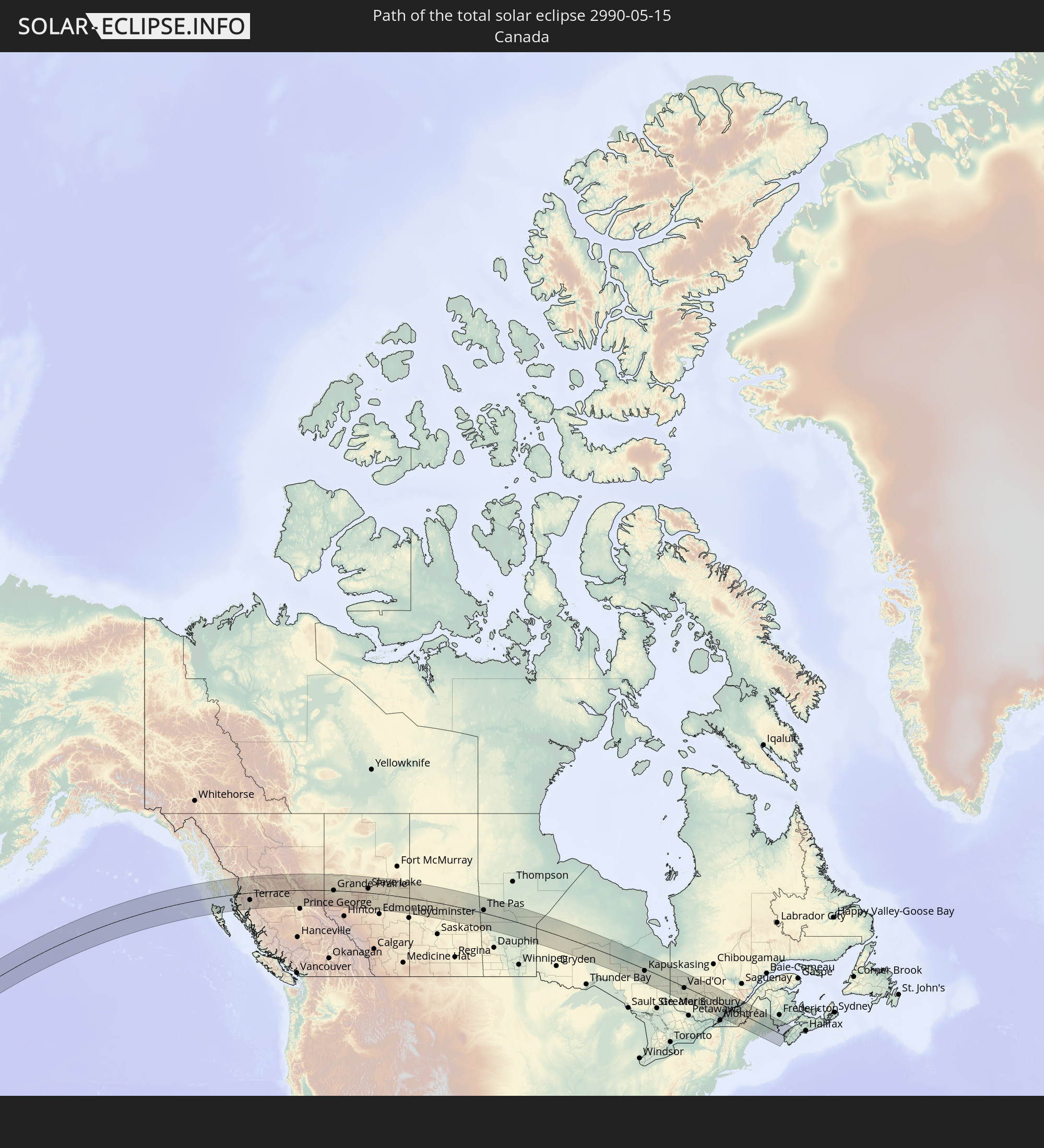 Kanada
 Föderierte Staaten von Mikronesien
In den folgenden Ländern ist die Sonnenfinsternis partiell zu sehen
 Russland
 Vereinigte Staaten
 United States Minor Outlying Islands
 Kiribati
 Kanada
 Mexiko
 Grönland
 Guatemala
 Honduras
 Belize
 Kuba
Kuba
 Spitzbergen
 Norwegen
 Volksrepublik China
 Mongolei
 Japan
Japan
 Nordkorea
 Südkorea
 Föderierte Staaten von Mikronesien
 Papua-Neuguinea
 Guam
Guam
 Nördliche Marianen
 Salomonen
 Marshallinseln
 Vanuatu
 Nauru
Nauru
 Tuvalu
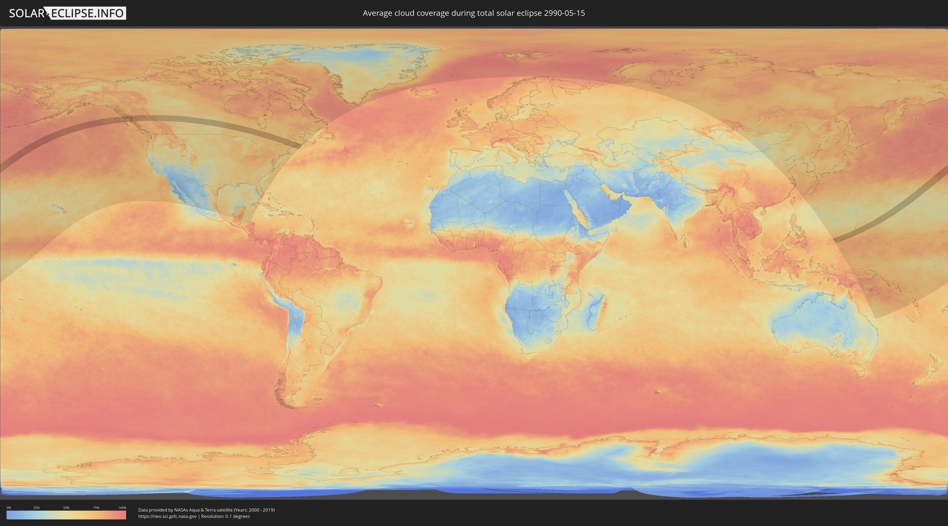
Wie wird das Wetter während der totalen Sonnenfinsternis am 15.05.2990?
Wo ist der beste Ort, um die totale Sonnenfinsternis vom 15.05.2990 zu beobachten?
Die folgenden Karten zeigen die durchschnittliche Bewölkung für den Tag, an dem die totale Sonnenfinsternis
stattfindet. Mit Hilfe der Karten lässt sich der Ort entlang des Finsternispfades eingrenzen,
der die besten Aussichen auf einen klaren wolkenfreien Himmel bietet.
Trotzdem muss man immer lokale Gegenenheiten beachten und sollte sich genau über das Wetter an seinem
gewählten Beobachtungsort informieren.
Die Daten stammen von den beiden NASA-Satelliten
AQUA und TERRA
und wurden über einen Zeitraum von 19 Jahren (2000 - 2019) gemittelt.

Detaillierte Länderkarten
 Vereinigte Staaten
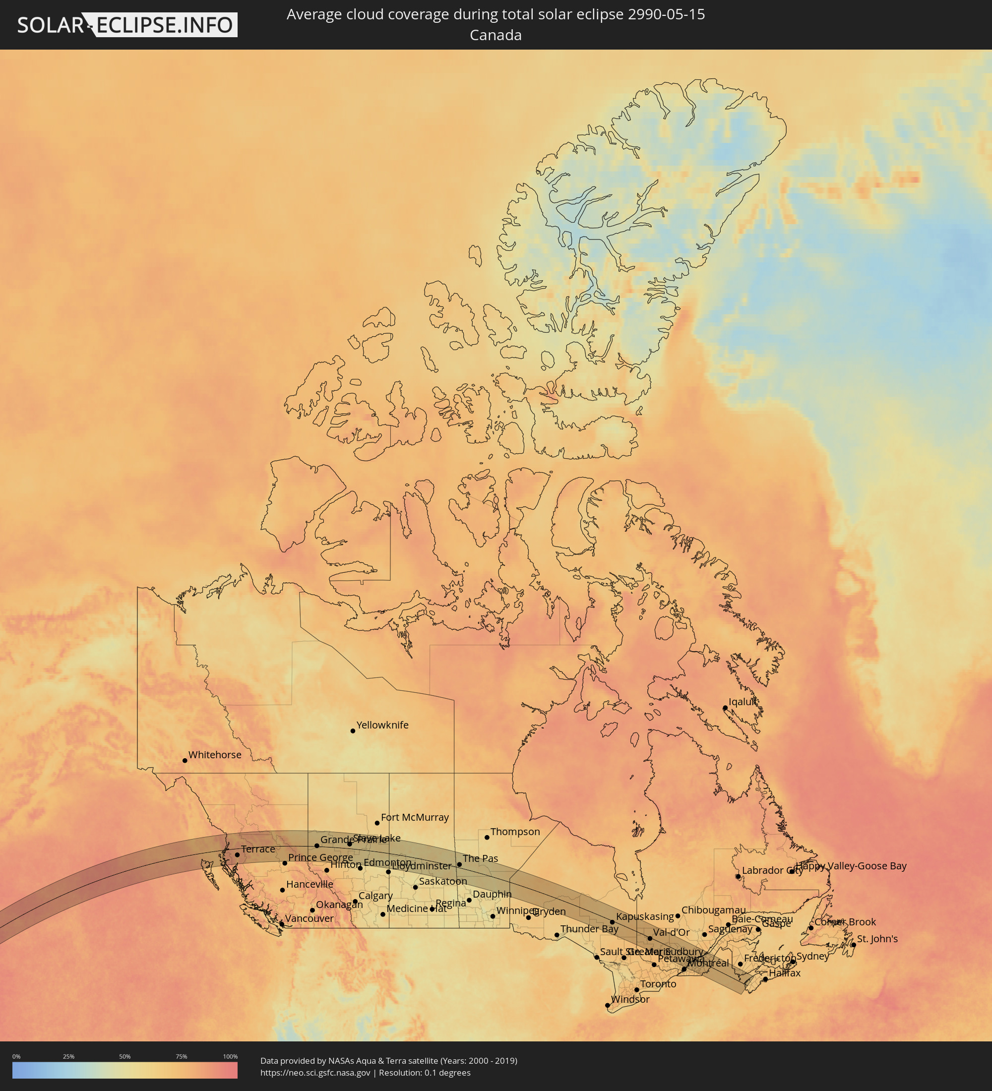 Kanada
 Föderierte Staaten von Mikronesien
Orte im Finsternispfad
Die nachfolgene Tabelle zeigt Städte und Orte mit mehr als 5.000 Einwohnern, die sich im Finsternispfad befinden. Städte mit mehr als 100.000 Einwohnern sind dick gekennzeichnet. Mit einem Klick auf den Ort öffnet sich eine Detailkarte die die Lage des jeweiligen Ortes zusammen mit dem Verlauf der zentralen Finsternis präsentiert.
| Ort | Typ | Dauer der Verfinsterung | Ortszeit bei maximaler Verfinsterung | Entfernung zur Zentrallinie | Ø Bewölkung |
|
Ketchikan, Alaska
|
total | - | 14:01:43 UTC-09:00 | 59 km | 76% |
|
Prince Rupert, British Columbia
|
total | - | 15:03:34 UTC-08:00 | 65 km | 78% |
|
Kitimat, British Columbia
|
total | - | 15:05:31 UTC-08:00 | 106 km | 77% |
|
Terrace, British Columbia
|
total | - | 15:05:21 UTC-08:00 | 55 km | 73% |
|
Smithers, British Columbia
|
total | - | 15:06:43 UTC-08:00 | 33 km | 75% |
|
Fort St. John, British Columbia
|
total | - | 16:11:46 UTC-07:00 | 118 km | 61% |
|
Dawson Creek, British Columbia
|
total | - | 16:12:40 UTC-07:00 | 64 km | 64% |
|
Grande Prairie, Alberta
|
total | - | 16:14:23 UTC-07:00 | 1 km | 61% |
|
Whitecourt, Alberta
|
total | - | 16:17:50 UTC-07:00 | 100 km | 66% |
|
Slave Lake, Alberta
|
total | - | 16:17:32 UTC-07:00 | 31 km | 57% |
|
Westlock, Alberta
|
total | - | 16:19:16 UTC-07:00 | 89 km | 57% |
|
Bonnyville, Alberta
|
total | - | 16:21:26 UTC-07:00 | 51 km | 54% |
|
Cold Lake, Alberta
|
total | - | 16:21:37 UTC-07:00 | 24 km | 55% |
|
Prince Albert, Saskatchewan
|
total | - | 17:25:42 UTC-06:00 | 112 km | 57% |
|
Flin Flon, Manitoba
|
total | - | 17:26:03 UTC-06:00 | 114 km | 52% |
|
The Pas, Manitoba
|
total | - | 17:27:24 UTC-06:00 | 22 km | 55% |
|
Kapuskasing, Ontario
|
total | - | 18:37:12 UTC-05:00 | 15 km | 67% |
|
Timmins, Ontario
|
total | - | 18:38:15 UTC-05:00 | 80 km | 71% |
|
Kirkland Lake, Ontario
|
total | - | 18:38:35 UTC-05:00 | 74 km | 73% |
|
La Sarre, Quebec
|
total | - | 18:37:53 UTC-05:00 | 18 km | 72% |
|
Rouyn-Noranda, Quebec
|
total | - | 18:38:28 UTC-05:00 | 34 km | 70% |
|
Amos, Quebec
|
total | - | 18:38:05 UTC-05:00 | 27 km | 71% |
|
Val-d'Or, Quebec
|
total | - | 18:38:33 UTC-05:00 | 10 km | 72% |
|
Mont-Laurier, Quebec
|
total | - | 18:39:55 UTC-05:00 | 93 km | 71% |
|
Mont-Tremblant, Quebec
|
total | - | 18:40:07 UTC-05:00 | 97 km | 67% |
|
Sainte-Agathe-des-Monts, Quebec
|
total | - | 18:40:14 UTC-05:00 | 103 km | 68% |
|
Sainte-Adèle, Quebec
|
total | - | 18:40:19 UTC-05:00 | 108 km | 69% |
|
Saint-Hippolyte, Quebec
|
total | - | 18:40:19 UTC-05:00 | 106 km | 69% |
|
Saint-Lin-Laurentides, Quebec
|
total | - | 18:40:21 UTC-05:00 | 106 km | 69% |
|
Rawdon, Quebec
|
total | - | 18:40:09 UTC-05:00 | 84 km | 69% |
|
Repentigny, Quebec
|
total | - | 18:40:24 UTC-05:00 | 106 km | 67% |
|
Notre-Dame-des-Prairies, Quebec
|
total | - | 18:40:06 UTC-05:00 | 75 km | 69% |
|
L'Assomption, Quebec
|
total | - | 18:40:19 UTC-05:00 | 98 km | 67% |
|
Joliette, Quebec
|
total | - | 18:40:08 UTC-05:00 | 78 km | 69% |
|
Lavaltrie, Quebec
|
total | - | 18:40:14 UTC-05:00 | 87 km | 69% |
|
Sorel-Tracy, Quebec
|
total | - | 18:40:04 UTC-05:00 | 66 km | 68% |
|
Saint-Hyacinthe, Quebec
|
total | - | 18:40:26 UTC-05:00 | 101 km | 69% |
|
Louiseville, Quebec
|
total | - | 18:39:50 UTC-05:00 | 38 km | 66% |
|
La Tuque, Quebec
|
total | - | 18:38:39 UTC-05:00 | 85 km | 68% |
|
Shawinigan, Quebec
|
total | - | 18:39:30 UTC-05:00 | 0 km | 68% |
|
Nicolet, Quebec
|
total | - | 18:39:49 UTC-05:00 | 31 km | 66% |
|
Sainte-Catherine, Quebec
|
total | - | 18:39:42 UTC-05:00 | 19 km | 65% |
|
Acton Vale, Quebec
|
total | - | 18:40:20 UTC-05:00 | 86 km | 70% |
|
Trois-Rivières, Quebec
|
total | - | 18:39:40 UTC-05:00 | 16 km | 67% |
|
Drummondville, Quebec
|
total | - | 18:40:06 UTC-05:00 | 60 km | 67% |
|
Bécancour, Quebec
|
total | - | 18:39:40 UTC-05:00 | 13 km | 67% |
|
Windsor, Quebec
|
total | - | 18:40:19 UTC-05:00 | 75 km | 69% |
|
Rock Forest, Quebec
|
total | - | 18:40:30 UTC-05:00 | 96 km | 71% |
|
Victoriaville, Quebec
|
total | - | 18:39:51 UTC-05:00 | 25 km | 69% |
|
Asbestos, Quebec
|
total | - | 18:40:07 UTC-05:00 | 52 km | 68% |
|
Sherbrooke, Quebec
|
total | - | 18:40:27 UTC-05:00 | 88 km | 72% |
|
Princeville, Quebec
|
total | - | 18:39:43 UTC-05:00 | 10 km | 70% |
|
Plessisville, Quebec
|
total | - | 18:39:39 UTC-05:00 | 2 km | 70% |
|
Donnacona, Quebec
|
total | - | 18:39:12 UTC-05:00 | 46 km | 67% |
|
Pont-Rouge, Quebec
|
total | - | 18:39:08 UTC-05:00 | 54 km | 67% |
|
Sainte Catherine de la Jacques Cartier, Quebec
|
total | - | 18:39:01 UTC-05:00 | 66 km | 67% |
|
Shannon, Quebec
|
total | - | 18:38:58 UTC-05:00 | 73 km | 68% |
|
Saint-Augustin-de-Desmaures, Quebec
|
total | - | 18:39:06 UTC-05:00 | 61 km | 68% |
|
L'Ancienne-Lorette, Quebec
|
total | - | 18:39:01 UTC-05:00 | 70 km | 67% |
|
Thetford-Mines, Quebec
|
total | - | 18:39:41 UTC-05:00 | 2 km | 66% |
|
Québec, Quebec
|
total | - | 18:38:59 UTC-05:00 | 76 km | 67% |
|
Lévis, Quebec
|
total | - | 18:38:59 UTC-05:00 | 77 km | 67% |
|
Saint-Henri, Quebec
|
total | - | 18:39:04 UTC-05:00 | 69 km | 70% |
|
Sainte-Marie, Quebec
|
total | - | 18:39:18 UTC-05:00 | 46 km | 68% |
|
Beauceville, Quebec
|
total | - | 18:39:27 UTC-05:00 | 32 km | 67% |
|
Saint-Georges, Quebec
|
total | - | 18:39:32 UTC-05:00 | 26 km | 70% |
|
Skowhegan, Maine
|
total | - | 18:40:33 UTC-05:00 | 76 km | 66% |
|
Waterville, Maine
|
total | - | 18:40:43 UTC-05:00 | 94 km | 68% |
|
Winslow, Maine
|
total | - | 18:40:43 UTC-05:00 | 94 km | 66% |
|
Belfast, Maine
|
total | - | 18:40:40 UTC-05:00 | 84 km | 67% |
|
Bangor, Maine
|
total | - | 18:40:17 UTC-05:00 | 39 km | 68% |
|
Brewer, Maine
|
total | - | 18:40:17 UTC-05:00 | 39 km | 68% |
|
Orono, Maine
|
total | - | 18:40:11 UTC-05:00 | 27 km | 68% |
|
Old Town, Maine
|
total | - | 18:40:08 UTC-05:00 | 21 km | 68% |
|
Ellsworth, Maine
|
total | - | 18:40:25 UTC-05:00 | 52 km | 66% |
|
Saint John, New Brunswick
|
total | - | 19:39:06 UTC-04:00 | 105 km | 69% |
|
Colonia, Yap
|
total | - | 06:39:30 UTC+10:00 | 62 km | 75% |