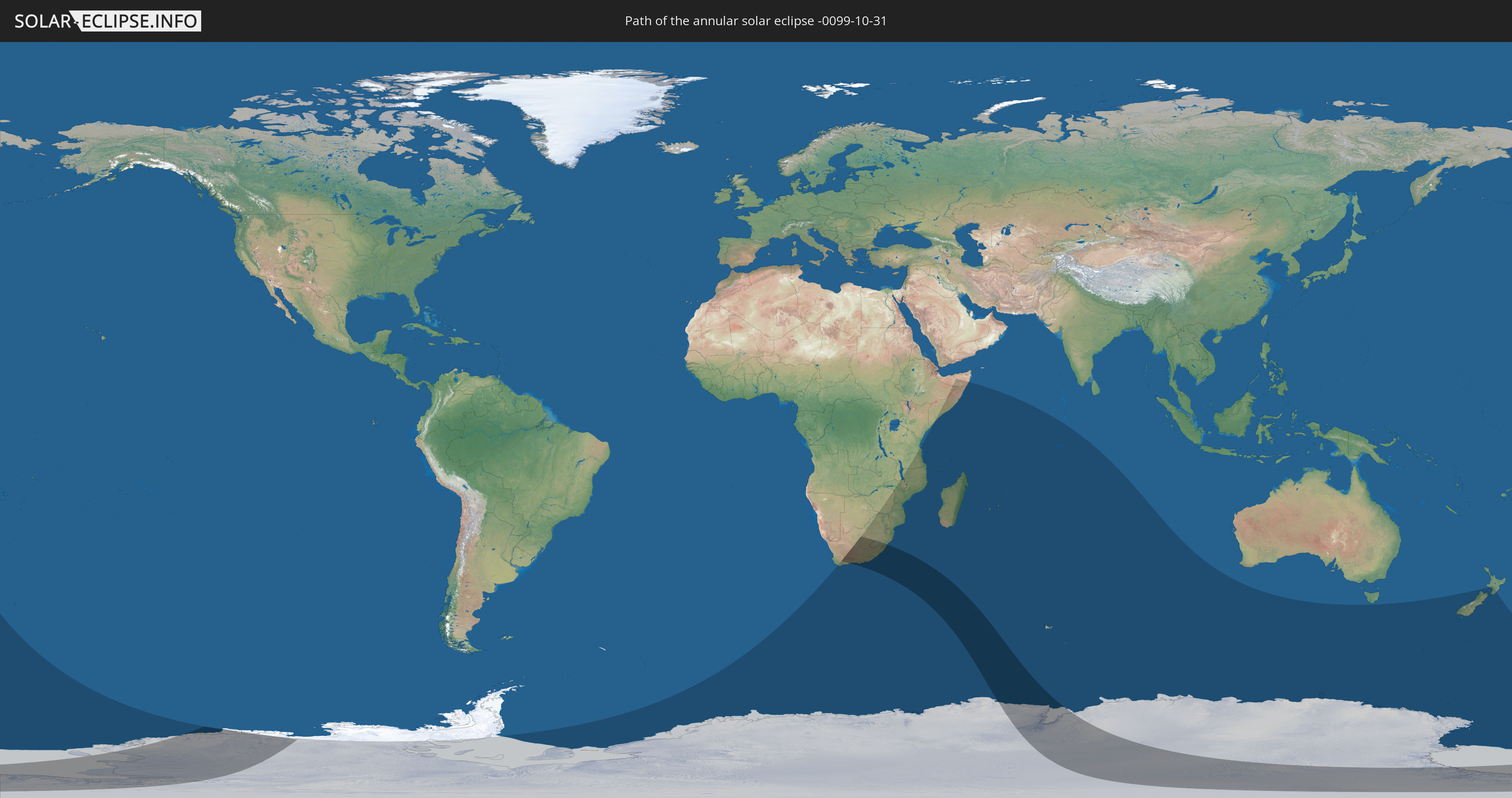
Annular solar eclipse of 10/31/-0099
| Day of week: | Wednesday |
| Maximum duration of eclipse: | 07m11s |
| Maximum width of eclipse path: | 594 km |
| Saros cycle: | 80 |
| Coverage: | 91.3% |
| Magnitude: | 0.9132 |
| Gamma: | -0.8354 |
Wo kann man die Sonnenfinsternis vom 10/31/-0099 sehen?
Die Sonnenfinsternis am 10/31/-0099 kann man in 23 Ländern als partielle Sonnenfinsternis beobachten.
Der Finsternispfad verläuft durch 4 Länder. Nur in diesen Ländern ist sie als annular Sonnenfinsternis zu sehen.
In den folgenden Ländern ist die Sonnenfinsternis annular zu sehen
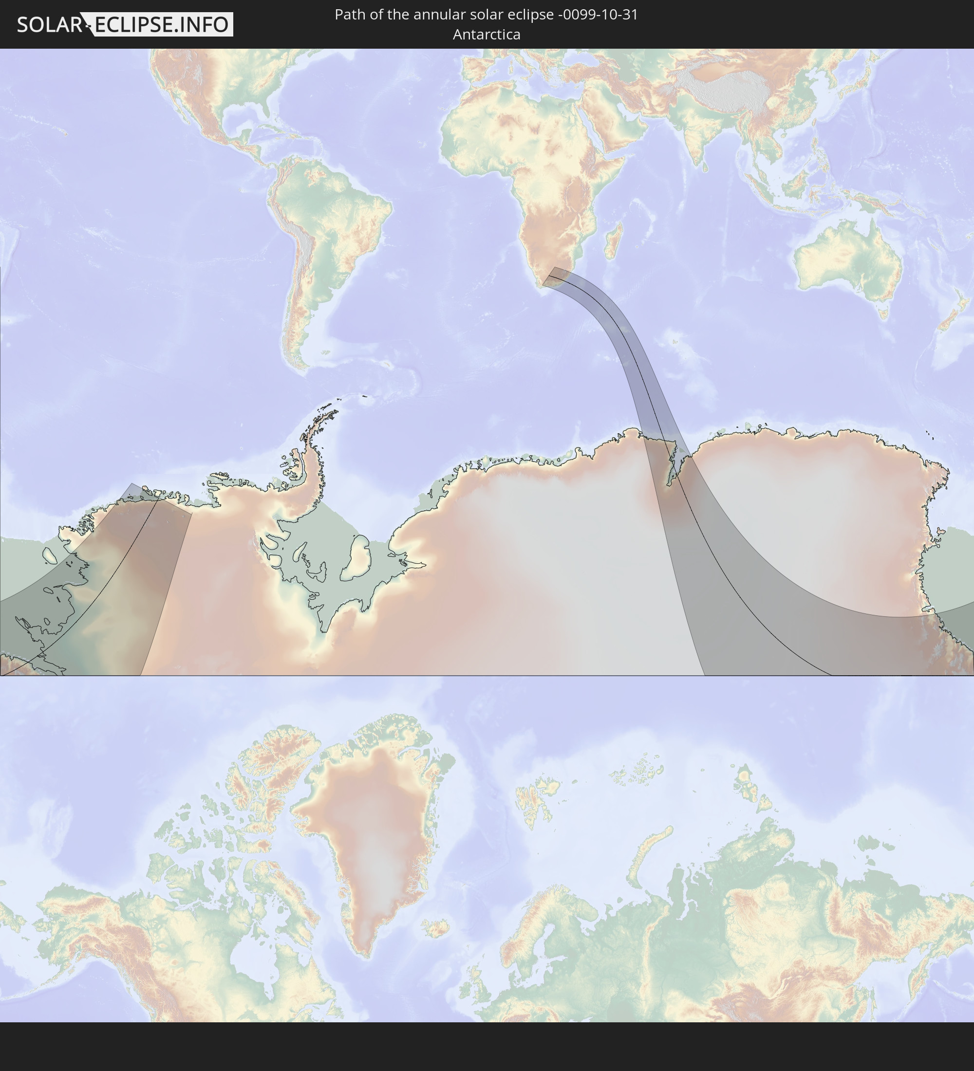 Antarctica
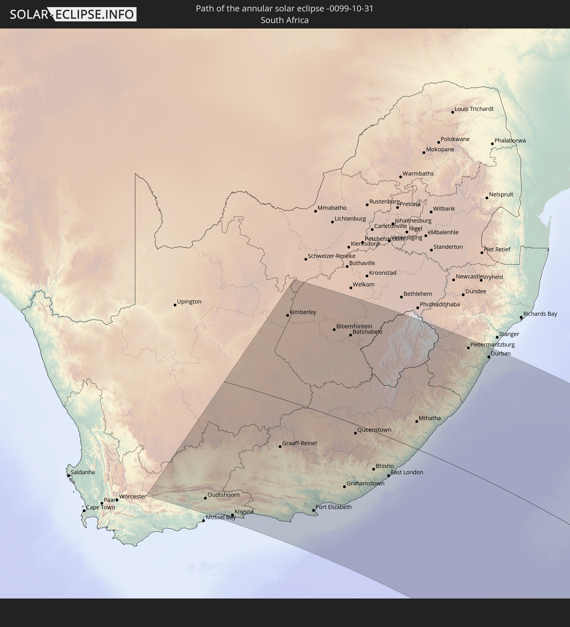 South Africa
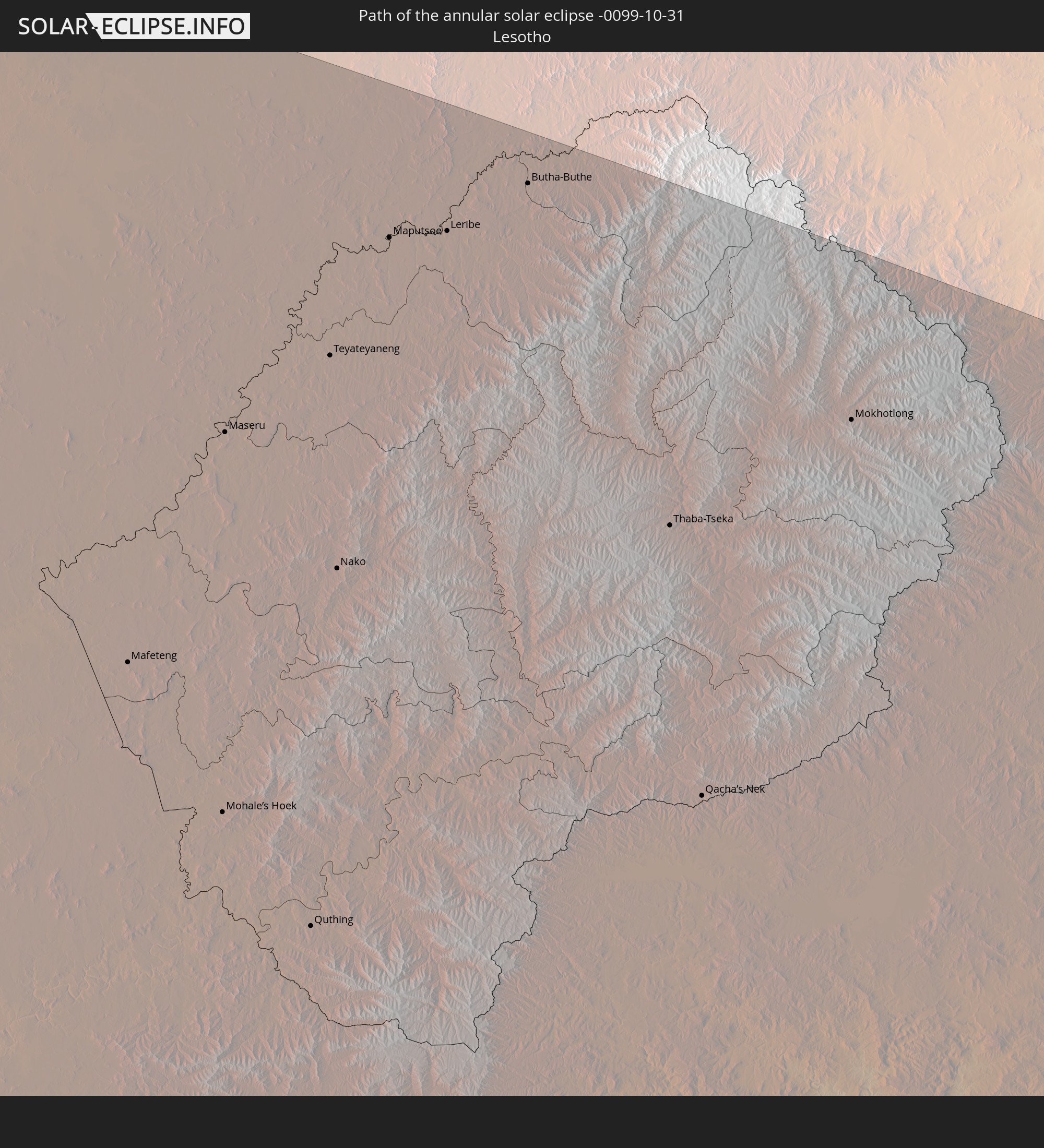 Lesotho
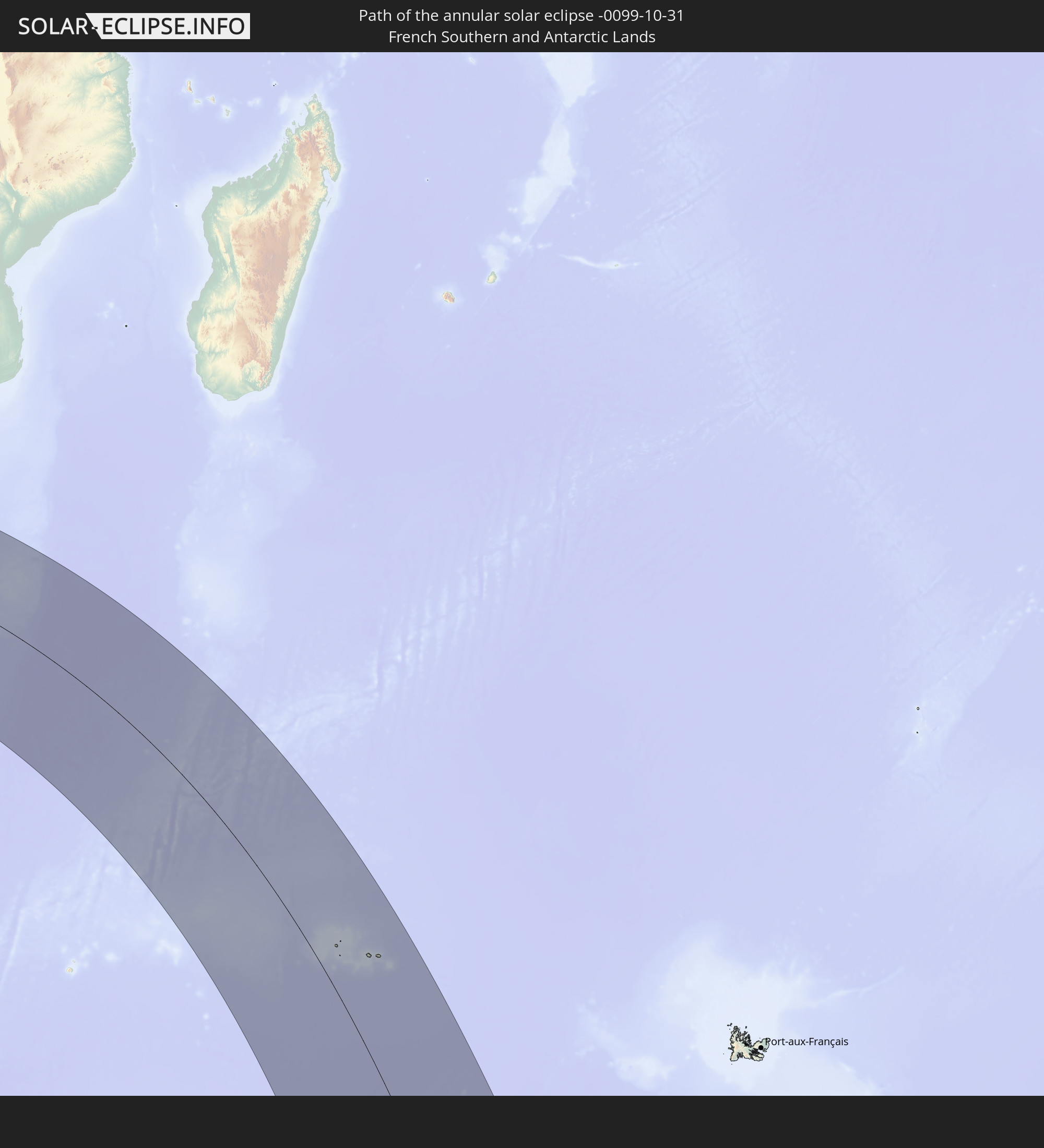 French Southern and Antarctic Lands
In den folgenden Ländern ist die Sonnenfinsternis partiell zu sehen
 Antarctica
 New Zealand
 Bouvet Island
 South Africa
 Botswana
 Zimbabwe
 Lesotho
 Tanzania
 Mozambique
 Swaziland
 Malawi
 Ethiopia
 French Southern and Antarctic Lands
 Somalia
 Madagascar
 Comoros
 Mayotte
 Seychelles
 Réunion
 Mauritius
 British Indian Ocean Territory
 Heard Island and McDonald Islands
 Australia
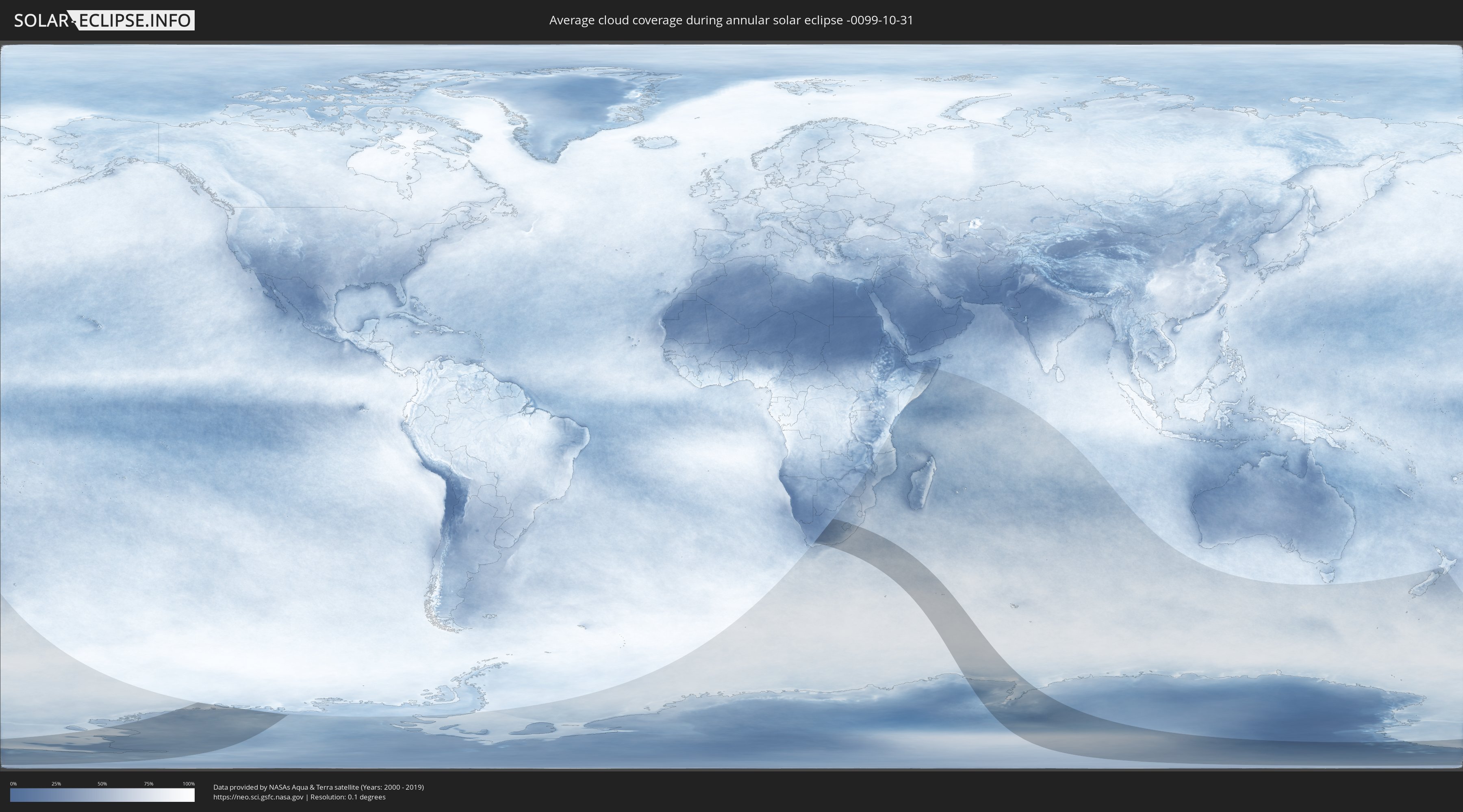
How will be the weather during the annular solar eclipse on 10/31/-0099?
Where is the best place to see the annular solar eclipse of 10/31/-0099?
The following maps show the average cloud coverage for the day of the annular solar eclipse.
With the help of these maps, it is possible to find the place along the eclipse path, which has the best
chance of a cloudless sky.
Nevertheless, you should consider local circumstances and inform about the weather of your chosen
observation site.
The data is provided by NASAs satellites
AQUA and TERRA.
The cloud maps are averaged over a period of 19 years (2000 - 2019).

Detailed country maps
 Antarctica
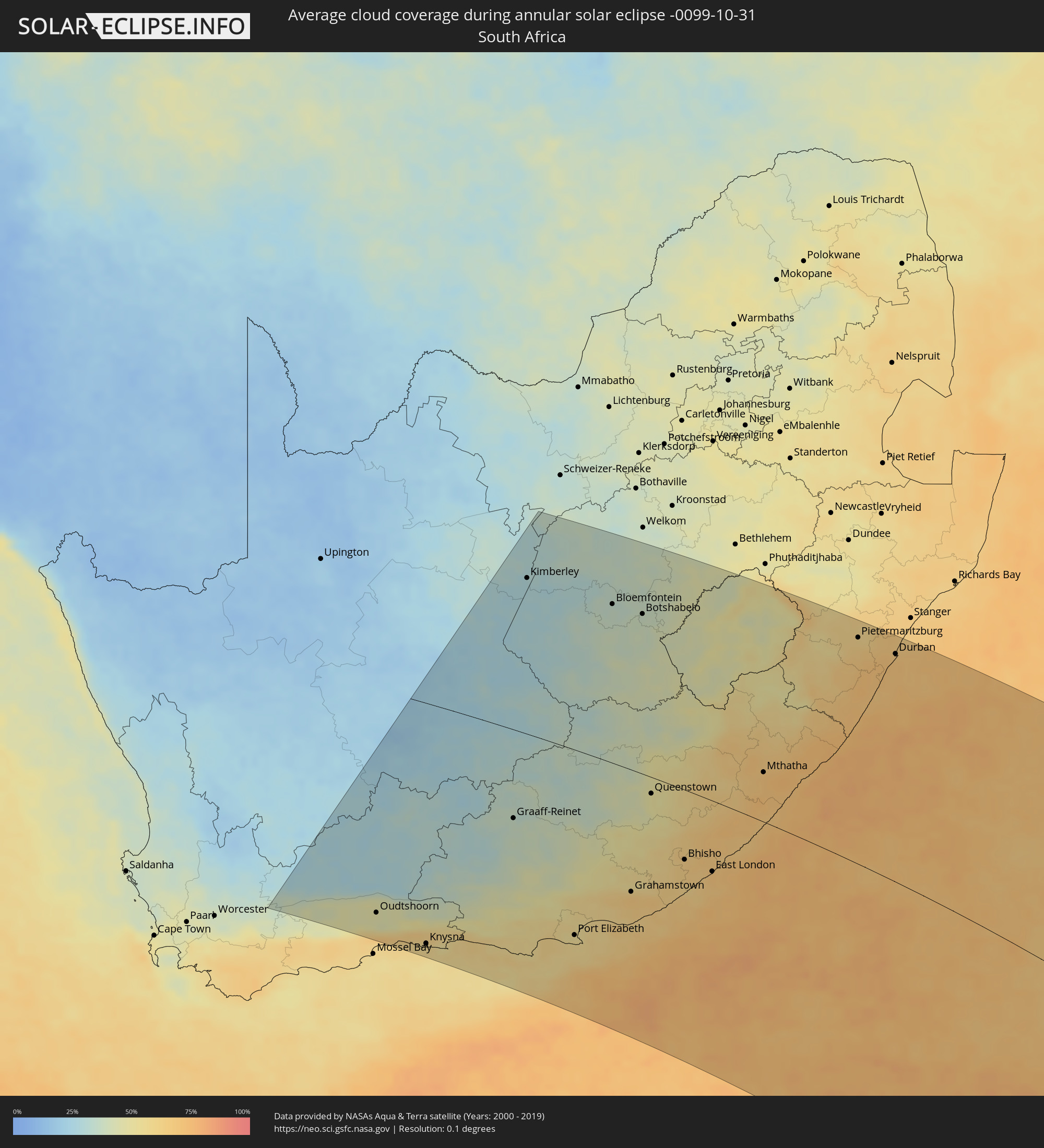 South Africa
 Lesotho
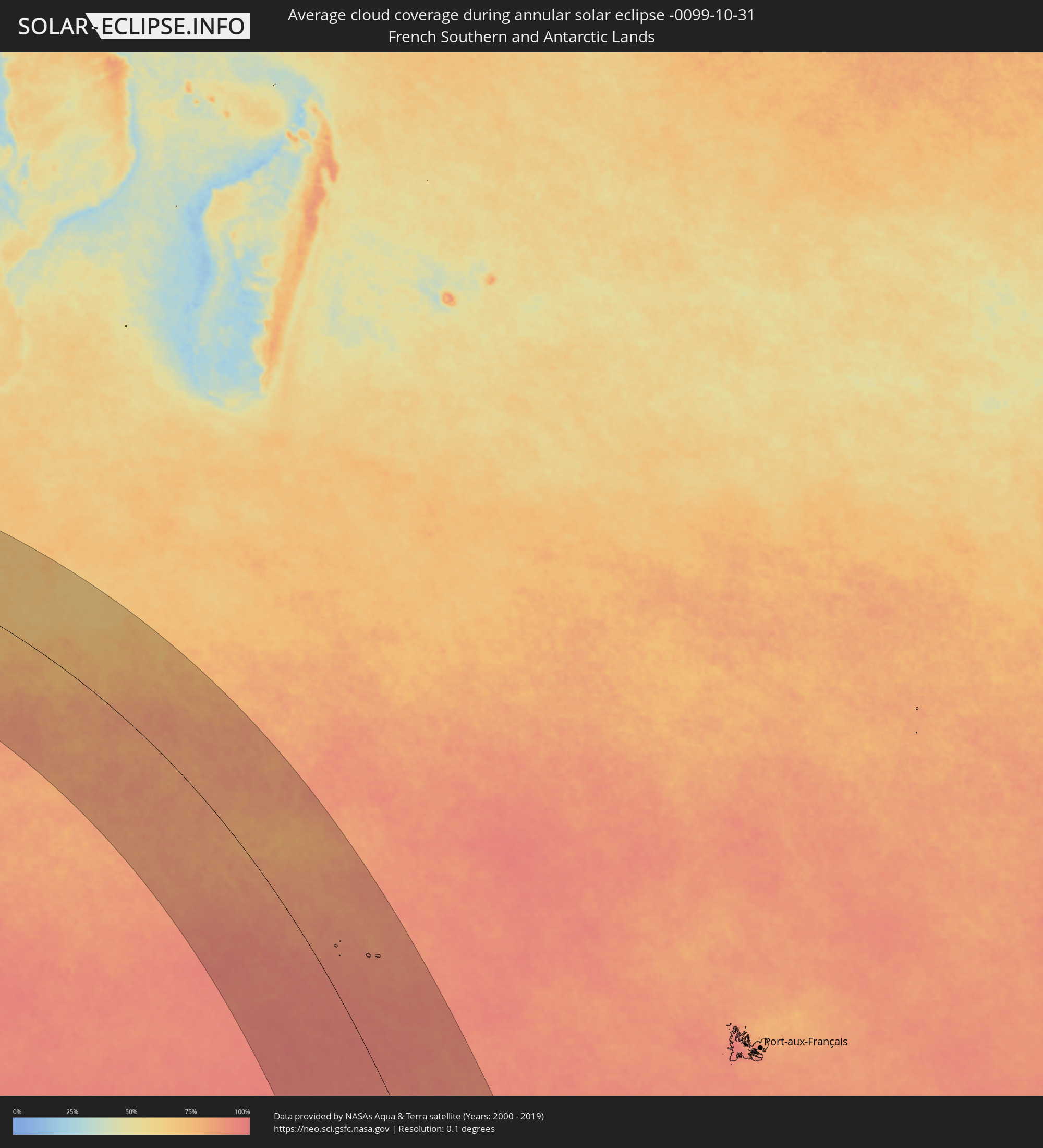 French Southern and Antarctic Lands
Cities inside the path of the eclipse
The following table shows all locations with a population of more than 5,000 inside the eclipse path. Cities which have more than 100,000 inhabitants are marked bold. A click at the locations opens a detailed map.
| City | Type | Eclipse duration | Local time of max. eclipse | Distance to central line | Ø Cloud coverage |
|
Ladismith, Western Cape
|
annular | - | 05:18:35 UTC+01:30 | 361 km | 43% |
|
Prince Albert, Western Cape
|
annular | - | 05:17:52 UTC+01:30 | 310 km | 31% |
|
Oudtshoorn, Western Cape
|
annular | - | 05:18:25 UTC+01:30 | 346 km | 45% |
|
George, Western Cape
|
annular | - | 05:18:56 UTC+01:30 | 377 km | 60% |
|
Beaufort West, Western Cape
|
annular | - | 05:16:16 UTC+01:30 | 203 km | 27% |
|
Knysna, Western Cape
|
annular | - | 05:18:51 UTC+01:30 | 369 km | 57% |
|
Plettenberg Bay, Western Cape
|
annular | - | 05:18:47 UTC+01:30 | 360 km | 59% |
|
Willowmore, Eastern Cape
|
annular | - | 05:17:29 UTC+01:30 | 277 km | 36% |
|
De Aar, Northern Cape
|
annular | - | 05:13:01 UTC+01:30 | 20 km | 26% |
|
Barkly West, Northern Cape
|
annular | - | 05:09:31 UTC+01:30 | 260 km | 29% |
|
Graaff-Reinet, Eastern Cape
|
annular | - | 05:15:26 UTC+01:30 | 136 km | 37% |
|
Ritchie, Northern Cape
|
annular | - | 05:10:16 UTC+01:30 | 207 km | 27% |
|
Kruisfontein, Eastern Cape
|
annular | - | 05:18:17 UTC+01:30 | 314 km | 57% |
|
Kimberley, Northern Cape
|
annular | - | 05:09:44 UTC+01:30 | 244 km | 29% |
|
Jan Kempdorp, North-West
|
annular | - | 05:08:27 UTC+01:30 | 333 km | 30% |
|
Warrenton, Northern Cape
|
annular | - | 05:08:45 UTC+01:30 | 313 km | 29% |
|
Jeffrey’s Bay, Eastern Cape
|
annular | - | 05:18:19 UTC+01:30 | 313 km | 57% |
|
Middelburg, Eastern Cape
|
annular | - | 05:14:02 UTC+01:30 | 44 km | 33% |
|
Colesberg, Northern Cape
|
annular | - | 05:12:46 UTC+01:30 | 43 km | 32% |
|
Christiana, North-West
|
annular | - | 05:08:19 UTC+01:30 | 343 km | 35% |
|
Uitenhage, Eastern Cape
|
annular | - | 05:17:41 UTC+01:30 | 267 km | 55% |
|
Kirkwood, Eastern Cape
|
annular | - | 05:17:03 UTC+01:30 | 229 km | 55% |
|
Port Elizabeth, Eastern Cape
|
annular | - | 05:17:54 UTC+01:30 | 278 km | 53% |
|
Somerset East, Eastern Cape
|
annular | - | 05:15:53 UTC+01:30 | 153 km | 44% |
|
Cradock, Eastern Cape
|
annular | - | 05:14:57 UTC+01:30 | 94 km | 39% |
|
Bloemfontein, Orange Free State
|
annular | - | 05:09:50 UTC+01:30 | 246 km | 36% |
|
Adelaide, Eastern Cape
|
annular | - | 05:15:39 UTC+01:30 | 128 km | 50% |
|
Burgersdorp, Eastern Cape
|
annular | - | 05:12:49 UTC+01:30 | 54 km | 40% |
|
Molteno, Eastern Cape
|
annular | - | 05:13:28 UTC+01:30 | 21 km | 40% |
|
Brandfort, Orange Free State
|
annular | - | 05:09:05 UTC+01:30 | 298 km | 38% |
|
Grahamstown, Eastern Cape
|
annular | - | 05:16:36 UTC+01:30 | 182 km | 67% |
|
Fort Beaufort, Eastern Cape
|
annular | - | 05:15:40 UTC+01:30 | 124 km | 56% |
|
Theunissen, Orange Free State
|
annular | - | 05:08:32 UTC+01:30 | 336 km | 38% |
|
Aliwal North, Eastern Cape
|
annular | - | 05:12:12 UTC+01:30 | 97 km | 39% |
|
Botshabelo, Orange Free State
|
annular | - | 05:09:54 UTC+01:30 | 246 km | 38% |
|
Whittlesea, Eastern Cape
|
annular | - | 05:14:37 UTC+01:30 | 55 km | 47% |
|
Alice, Eastern Cape
|
annular | - | 05:15:38 UTC+01:30 | 121 km | 57% |
|
Thaba Nchu, Orange Free State
|
annular | - | 05:09:46 UTC+01:30 | 256 km | 38% |
|
Queenstown, Eastern Cape
|
annular | - | 05:14:08 UTC+01:30 | 25 km | 50% |
|
Port Alfred, Eastern Cape
|
annular | - | 05:16:59 UTC+01:30 | 200 km | 65% |
|
Queensdale, Eastern Cape
|
annular | - | 05:14:04 UTC+01:30 | 19 km | 49% |
|
Winburg, Orange Free State
|
annular | - | 05:08:36 UTC+01:30 | 334 km | 38% |
|
Ilinge, Eastern Cape
|
annular | - | 05:14:13 UTC+01:30 | 27 km | 51% |
|
Dordrecht, Eastern Cape
|
annular | - | 05:13:13 UTC+01:30 | 36 km | 51% |
|
Zastron, Orange Free State
|
annular | - | 05:11:27 UTC+01:30 | 149 km | 43% |
|
Lady Frere, Eastern Cape
|
annular | - | 05:13:43 UTC+01:30 | 8 km | 53% |
|
Mafeteng, Mafeteng
|
annular | - | 05:10:37 UTC+01:30 | 204 km | 44% |
|
Stutterheim, Eastern Cape
|
annular | - | 05:15:07 UTC+01:30 | 79 km | 63% |
|
Marquard, Orange Free State
|
annular | - | 05:08:42 UTC+01:30 | 333 km | 43% |
|
Bhisho, Eastern Cape
|
annular | - | 05:15:35 UTC+01:30 | 105 km | 64% |
|
Ladybrand, Orange Free State
|
annular | - | 05:09:32 UTC+01:30 | 277 km | 44% |
|
Mohale’s Hoek, Mohaleʼs Hoek
|
annular | - | 05:11:05 UTC+01:30 | 177 km | 43% |
|
Maseru, Maseru
|
annular | - | 05:09:44 UTC+01:30 | 265 km | 44% |
|
Clocolan, Orange Free State
|
annular | - | 05:09:03 UTC+01:30 | 310 km | 45% |
|
Quthing, Quthing
|
annular | - | 05:11:26 UTC+01:30 | 159 km | 49% |
|
Teyateyaneng, Berea
|
annular | - | 05:09:22 UTC+01:30 | 292 km | 46% |
|
Nako, Maseru
|
annular | - | 05:10:08 UTC+01:30 | 243 km | 45% |
|
Elliot, Eastern Cape
|
annular | - | 05:12:56 UTC+01:30 | 68 km | 61% |
|
Maputsoe, Leribe
|
annular | - | 05:08:55 UTC+01:30 | 325 km | 44% |
|
East London, Eastern Cape
|
annular | - | 05:15:45 UTC+01:30 | 105 km | 69% |
|
Leribe, Leribe
|
annular | - | 05:08:50 UTC+01:30 | 330 km | 42% |
|
Butterworth, Eastern Cape
|
annular | - | 05:14:31 UTC+01:30 | 26 km | 71% |
|
Butha-Buthe, Butha-Buthe
|
annular | - | 05:08:37 UTC+01:30 | 348 km | 42% |
|
Thaba-Tseka, Thaba-Tseka
|
annular | - | 05:09:44 UTC+01:30 | 281 km | 47% |
|
Qacha’s Nek, Qachaʼs Nek
|
annular | - | 05:10:41 UTC+01:30 | 223 km | 51% |
|
Mthatha, Eastern Cape
|
annular | - | 05:13:07 UTC+01:30 | 73 km | 71% |
|
Mokhotlong, Mokhotlong
|
annular | - | 05:09:13 UTC+01:30 | 322 km | 48% |
|
Kokstad, KwaZulu-Natal
|
annular | - | 05:11:12 UTC+01:30 | 204 km | 50% |
|
Port Saint John’s, Eastern Cape
|
annular | - | 05:12:59 UTC+01:30 | 99 km | 71% |
|
Mpophomeni, KwaZulu-Natal
|
annular | - | 05:09:23 UTC+01:30 | 333 km | 62% |
|
Howick, KwaZulu-Natal
|
annular | - | 05:09:13 UTC+01:30 | 344 km | 61% |
|
Richmond, KwaZulu-Natal
|
annular | - | 05:09:52 UTC+01:30 | 305 km | 67% |
|
Margate, KwaZulu-Natal
|
annular | - | 05:11:30 UTC+01:30 | 207 km | 75% |
|
Pietermaritzburg, KwaZulu-Natal
|
annular | - | 05:09:24 UTC+01:30 | 335 km | 63% |
|
Port Shepstone, KwaZulu-Natal
|
annular | - | 05:11:17 UTC+01:30 | 222 km | 73% |
|
Mpumalanga, KwaZulu-Natal
|
annular | - | 05:09:40 UTC+01:30 | 325 km | 68% |
|
Scottburgh, KwaZulu-Natal
|
annular | - | 05:10:27 UTC+01:30 | 280 km | 69% |
|
Umkomaas, KwaZulu-Natal
|
annular | - | 05:10:18 UTC+01:30 | 290 km | 70% |
|
Berea, KwaZulu-Natal
|
annular | - | 05:09:39 UTC+01:30 | 334 km | 70% |
|
Durban, KwaZulu-Natal
|
annular | - | 05:09:39 UTC+01:30 | 335 km | 70% |