Total solar eclipse of 04/15/-0135
| Day of week: | Thursday |
| Maximum duration of eclipse: | 03m39s |
| Maximum width of eclipse path: | 244 km |
| Saros cycle: | 75 |
| Coverage: | 100% |
| Magnitude: | 1.0526 |
| Gamma: | 0.7119 |
Wo kann man die Sonnenfinsternis vom 04/15/-0135 sehen?

Die Sonnenfinsternis am 04/15/-0135 kann man in 112 Ländern als partielle Sonnenfinsternis beobachten.
Der Finsternispfad verläuft durch 12 Länder. Nur in diesen Ländern ist sie als total Sonnenfinsternis zu sehen.
In den folgenden Ländern ist die Sonnenfinsternis total zu sehen
 Russia
 Niger
Niger
 Libya
Libya
 Chad
Chad
 Sudan
Sudan
 Egypt
Egypt
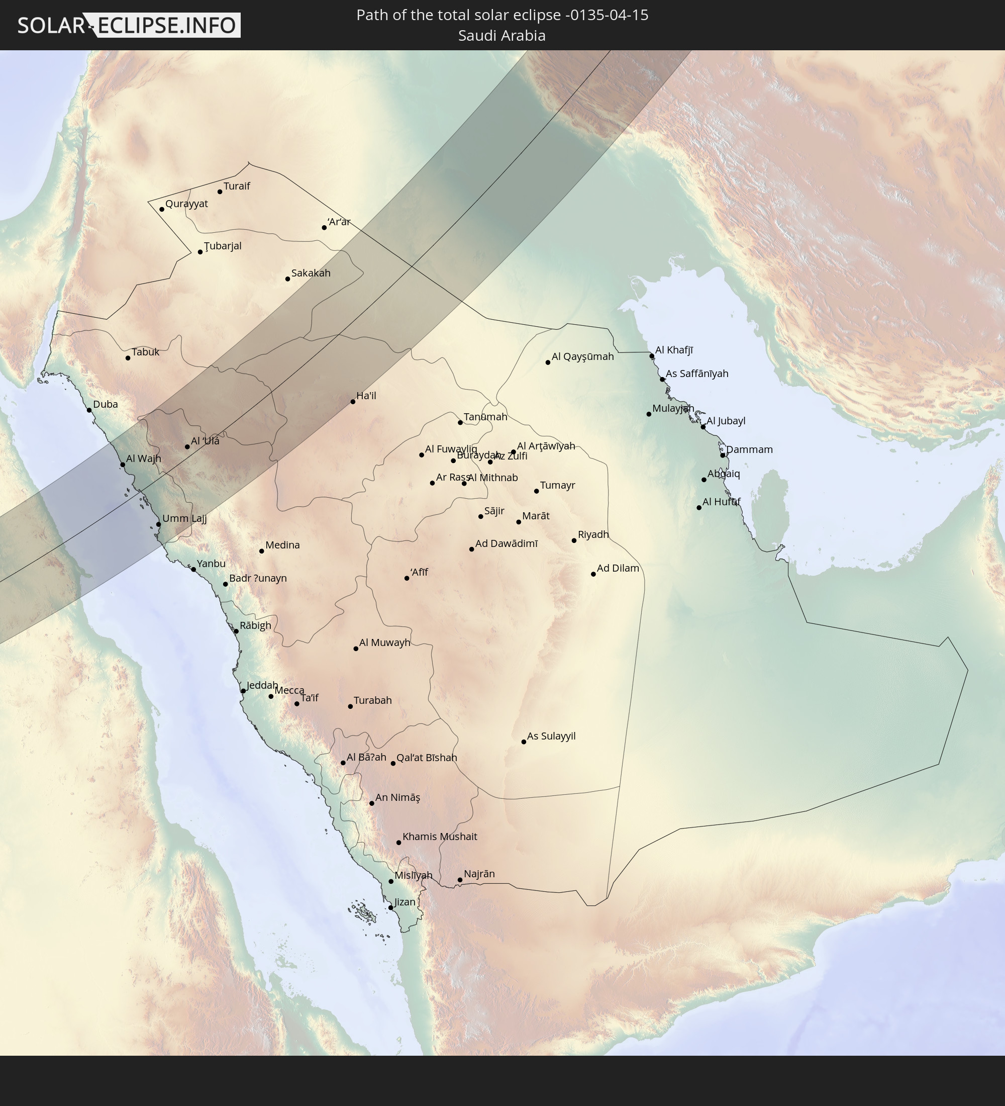 Saudi Arabia
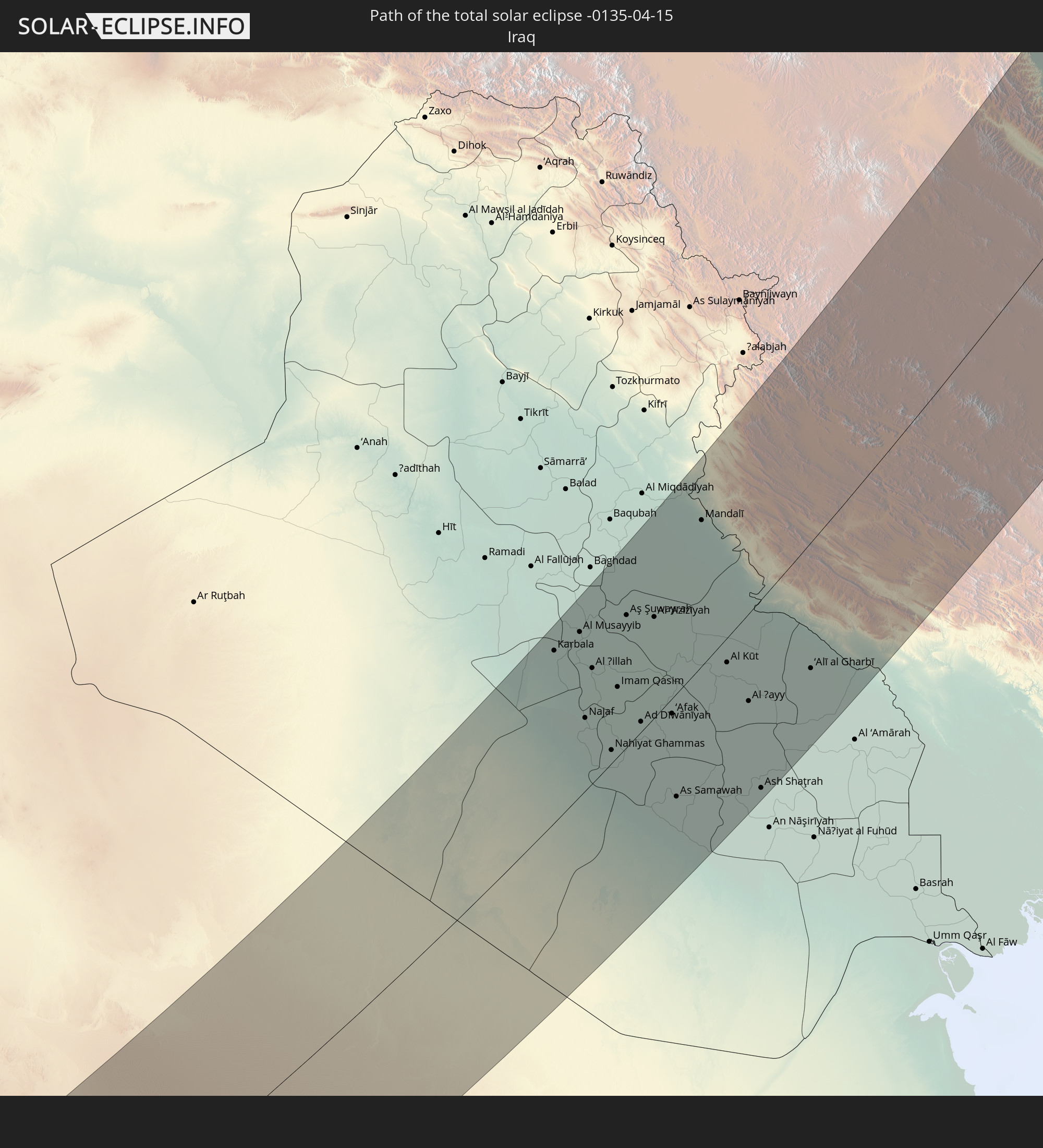 Iraq
Iraq
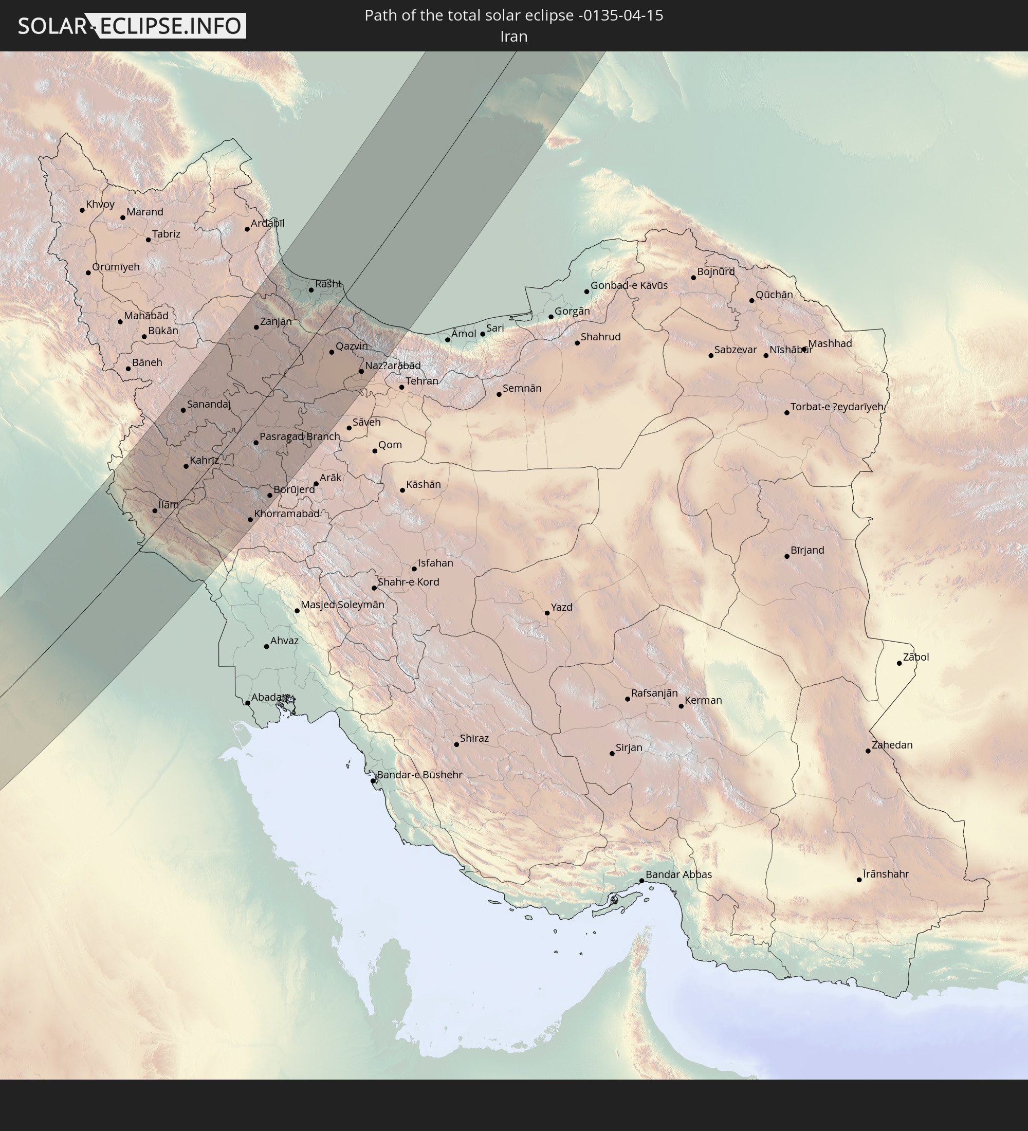 Iran
Iran
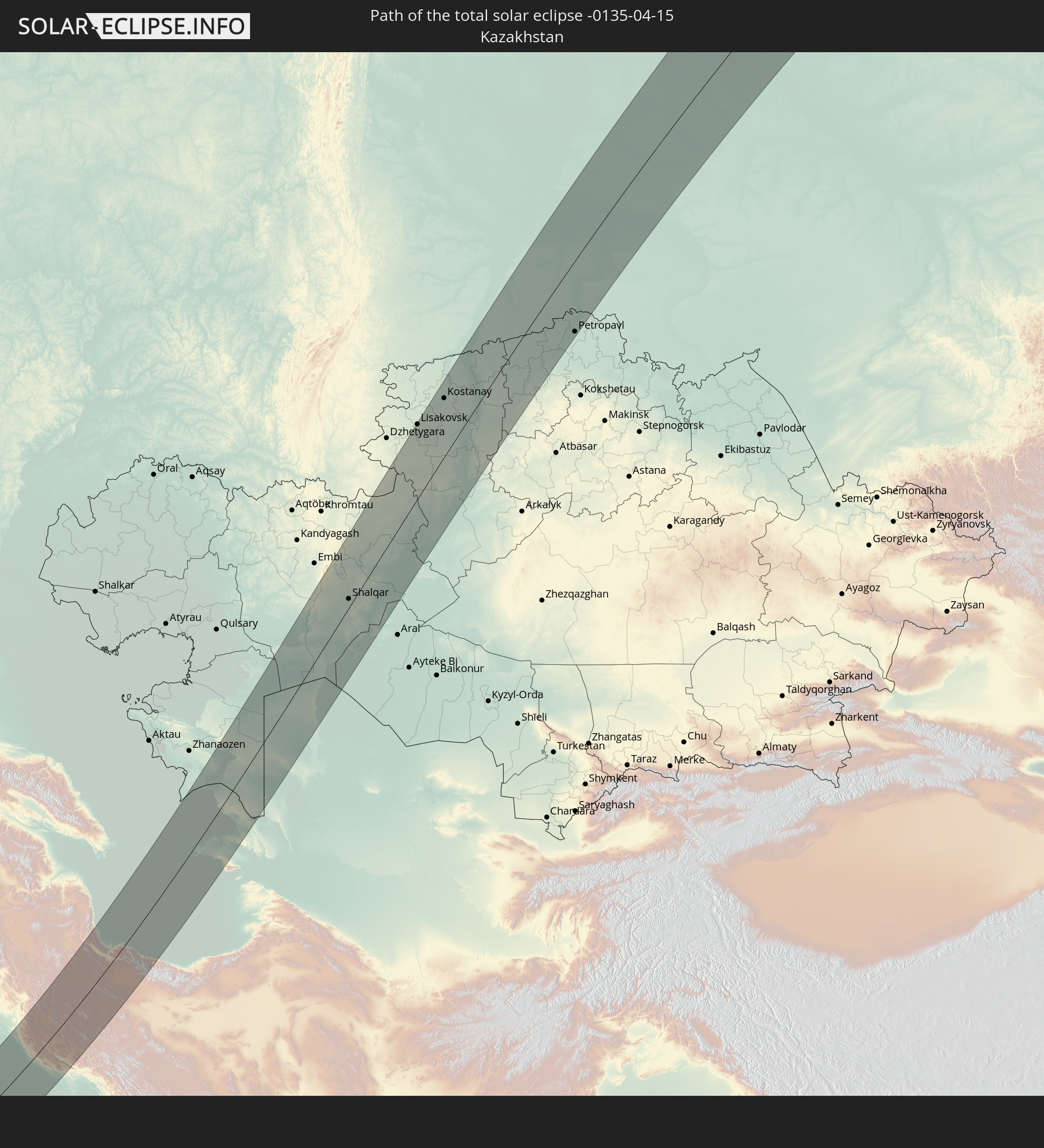 Kazakhstan
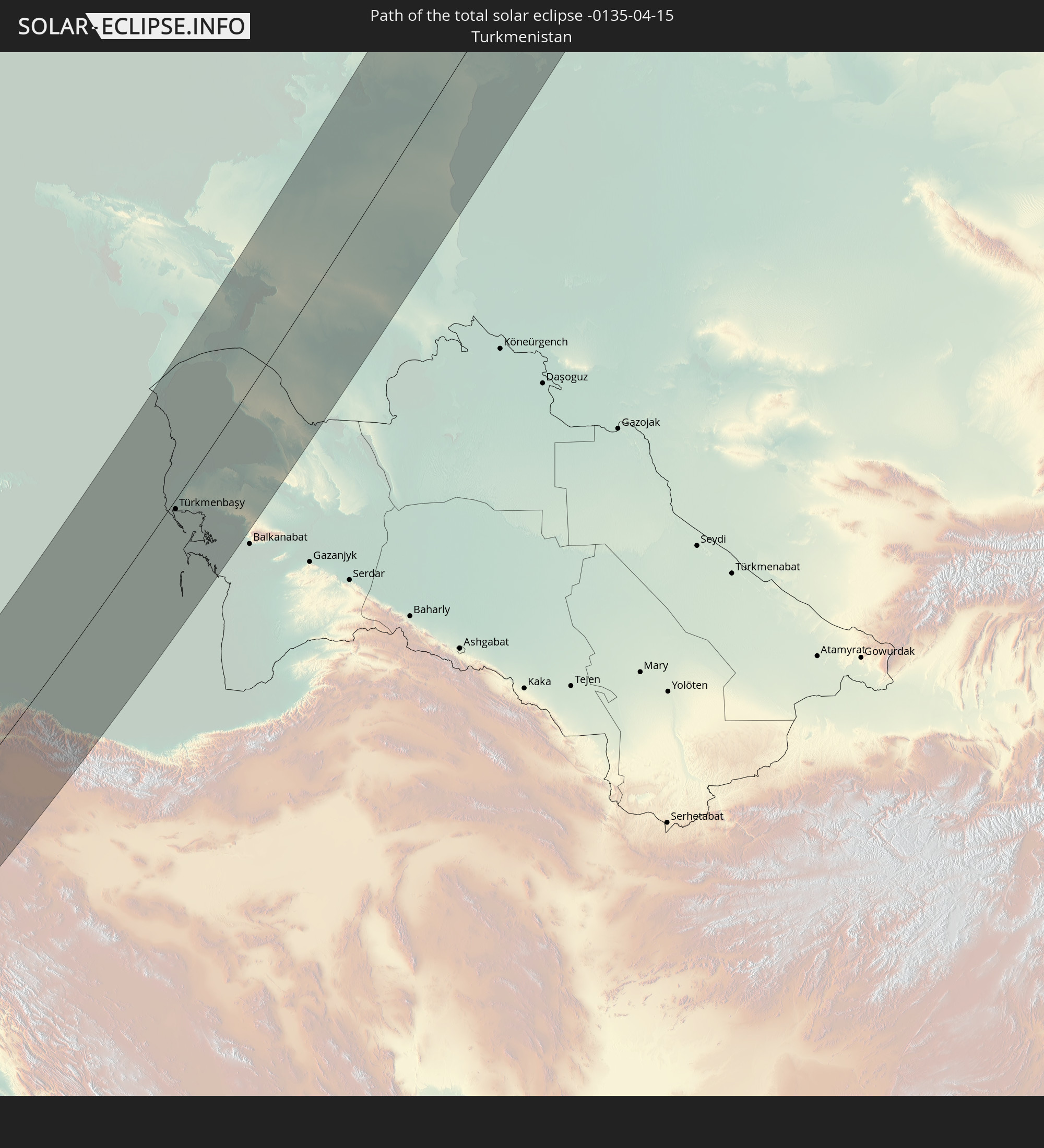 Turkmenistan
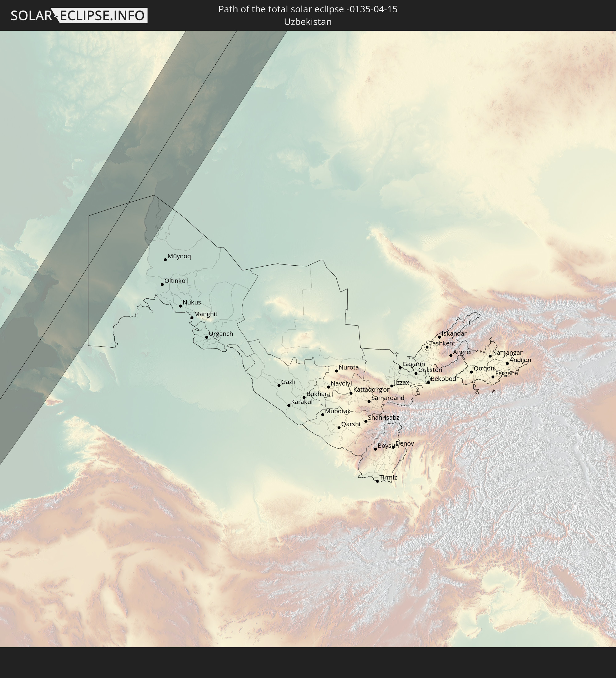 Uzbekistan
In den folgenden Ländern ist die Sonnenfinsternis partiell zu sehen
 Russia
 Canada
 Greenland
 Iceland
 Spain
Spain
 Republic of Ireland
 Svalbard and Jan Mayen
 Algeria
 United Kingdom
 Faroe Islands
 France
 Isle of Man
 Guernsey
 Jersey
 Niger
Niger
 Andorra
 Belgium
 Netherlands
 Norway
 Luxembourg
 Germany
 Switzerland
 Italy
Italy
 Monaco
 Tunisia
 Denmark
 Libya
Libya
 Liechtenstein
 Austria
 Sweden
 Czechia
 Democratic Republic of the Congo
 San Marino
 Vatican City
 Slovenia
 Chad
Chad
 Croatia
 Poland
 Malta
Malta
 Central African Republic
 Bosnia and Herzegovina
 Hungary
 Slovakia
 Montenegro
 Serbia
 Albania
 Åland Islands
 Greece
 Romania
 Republic of Macedonia
 Finland
 Lithuania
 Latvia
 Estonia
 Sudan
Sudan
 Zambia
 Ukraine
 Bulgaria
 Belarus
 Egypt
Egypt
 Zimbabwe
 Turkey
 Moldova
 Rwanda
 Burundi
 Tanzania
 Uganda
 Mozambique
 Cyprus
 Malawi
 Ethiopia
 Kenya
Kenya
 State of Palestine
 Israel
 Saudi Arabia
 Jordan
 Lebanon
 Syria
Syria
 Eritrea
 Iraq
Iraq
 Georgia
 French Southern and Antarctic Lands
 Somalia
 Djibouti
 Yemen
Yemen
 Comoros
 Armenia
 Iran
Iran
 Azerbaijan
 Mayotte
 Seychelles
 Kazakhstan
 Kuwait
 Bahrain
 Qatar
Qatar
 United Arab Emirates
 Oman
Oman
 Turkmenistan
 Uzbekistan
 Afghanistan
 Pakistan
 Tajikistan
 India
India
 Kyrgyzstan
 Maldives
 China
China
 Nepal
Nepal
 Mongolia
 Bangladesh
 Bhutan
 Japan
Japan
 North Korea
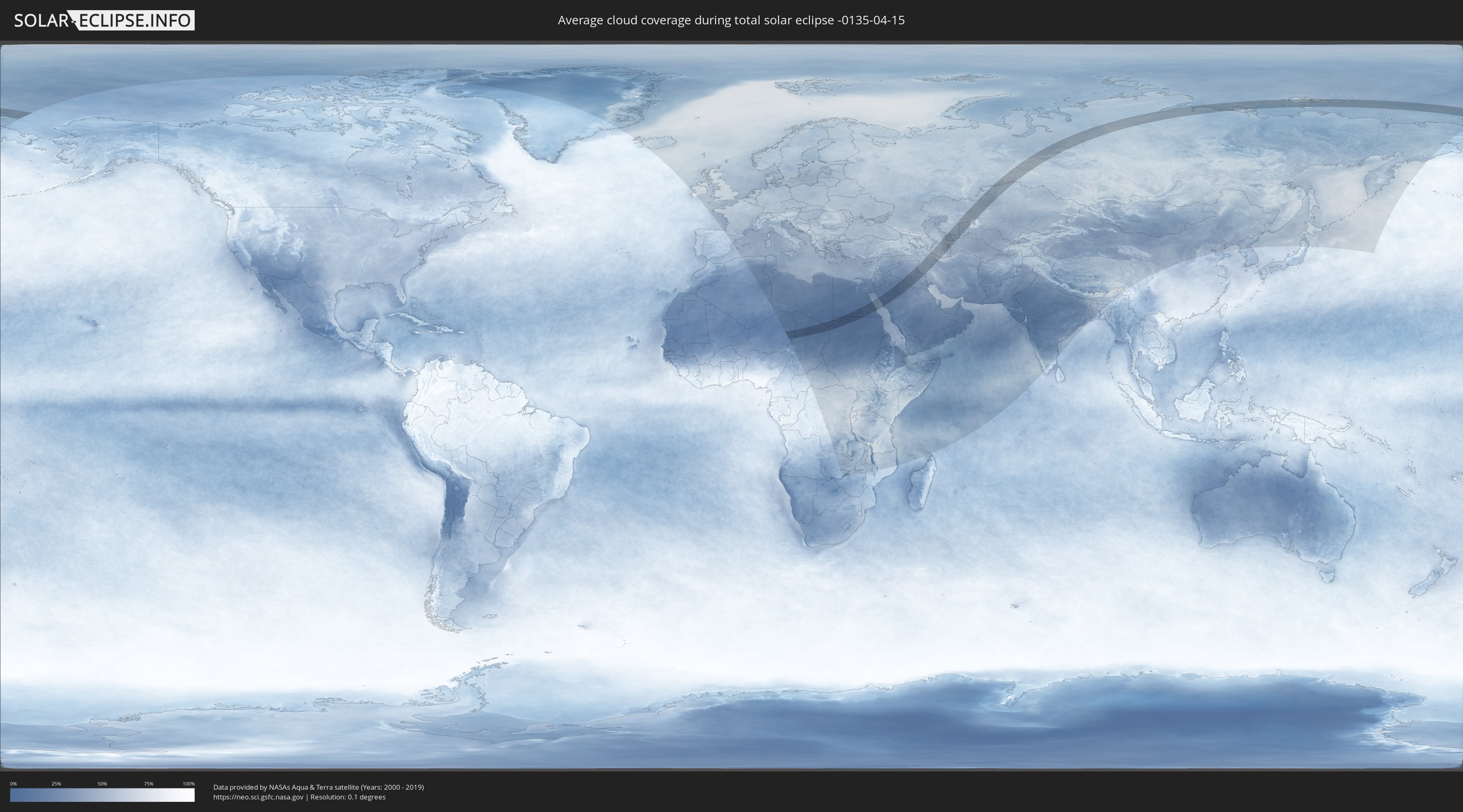
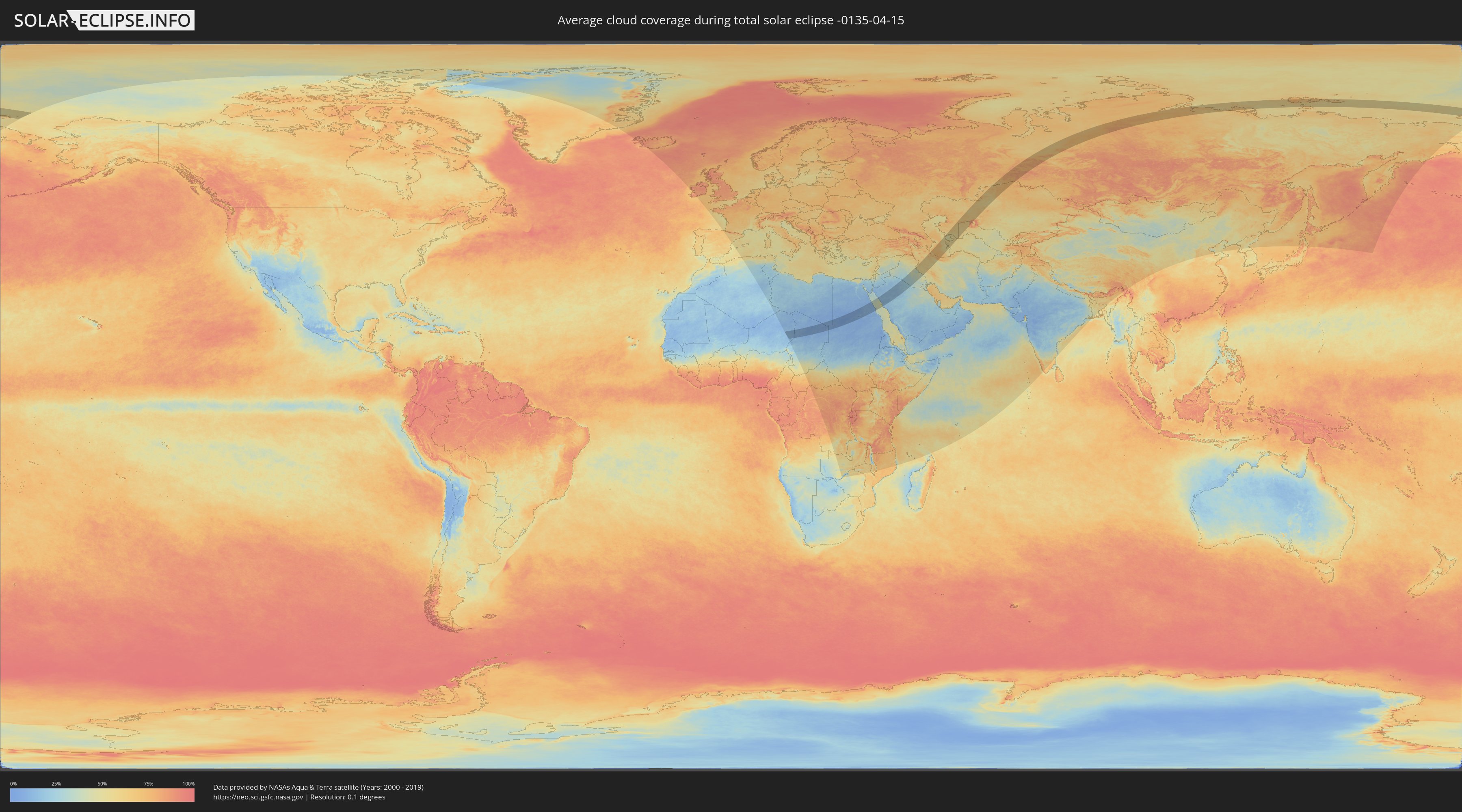
How will be the weather during the total solar eclipse on 04/15/-0135?
Where is the best place to see the total solar eclipse of 04/15/-0135?
The following maps show the average cloud coverage for the day of the total solar eclipse.
With the help of these maps, it is possible to find the place along the eclipse path, which has the best
chance of a cloudless sky.
Nevertheless, you should consider local circumstances and inform about the weather of your chosen
observation site.
The data is provided by NASAs satellites
AQUA and TERRA.
The cloud maps are averaged over a period of 19 years (2000 - 2019).
Detailed country maps
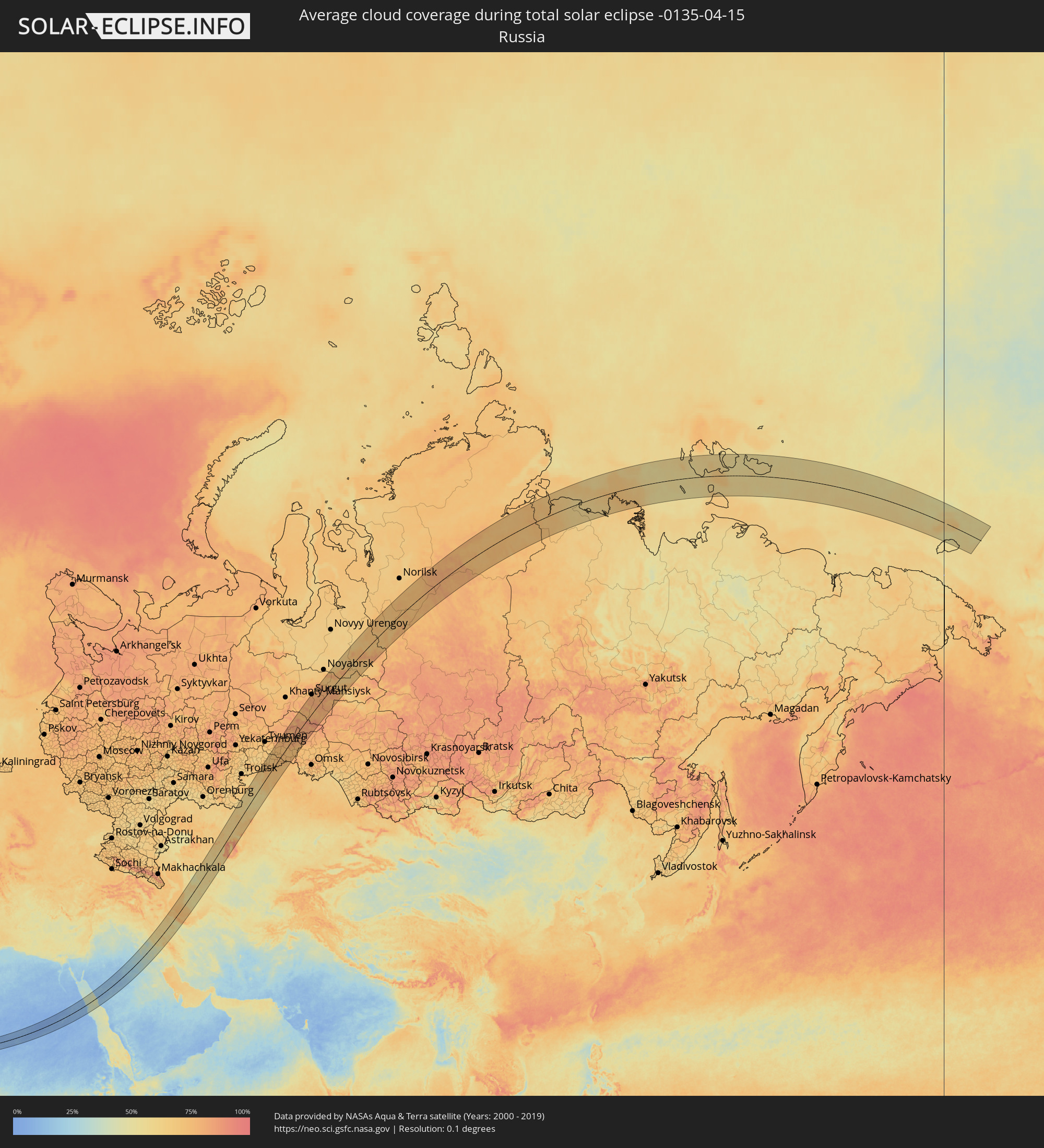 Russia
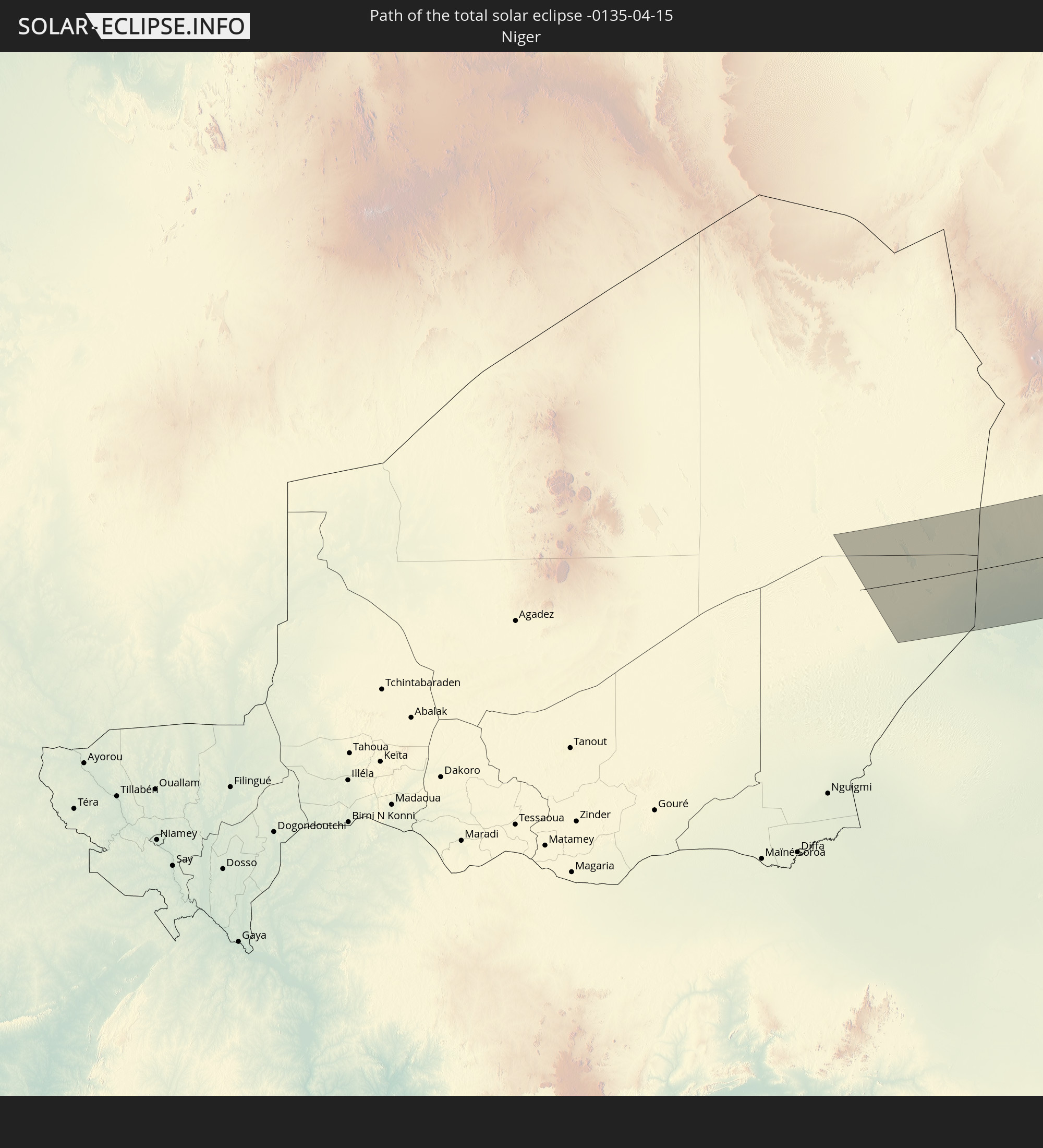
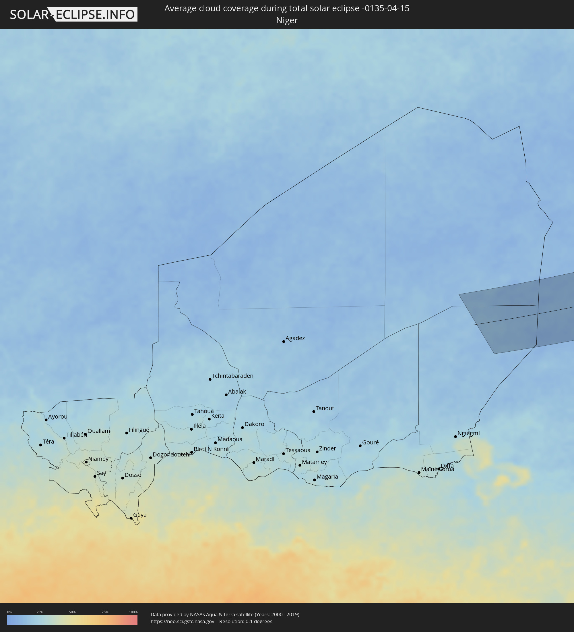 Niger
Niger
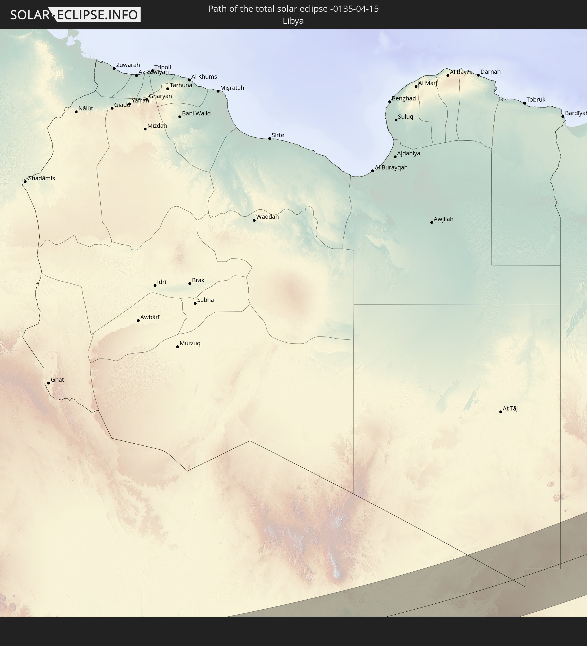
 Libya
Libya
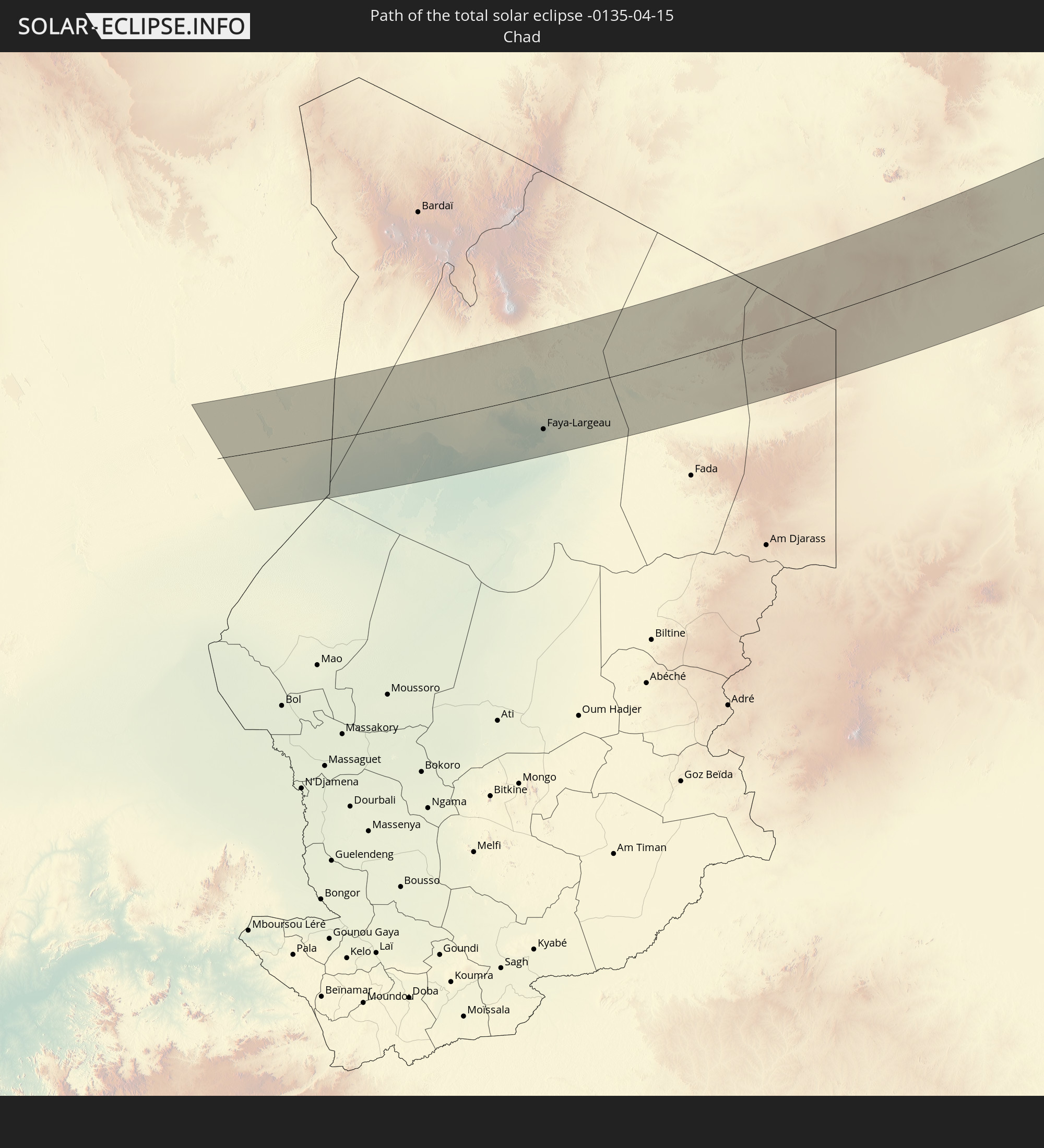
 Chad
Chad
 Sudan
Sudan
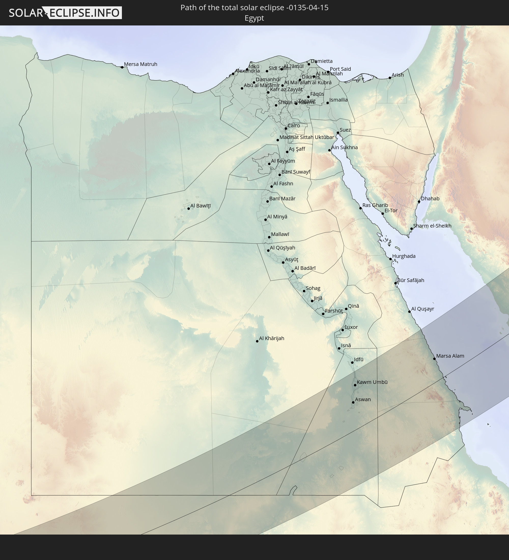
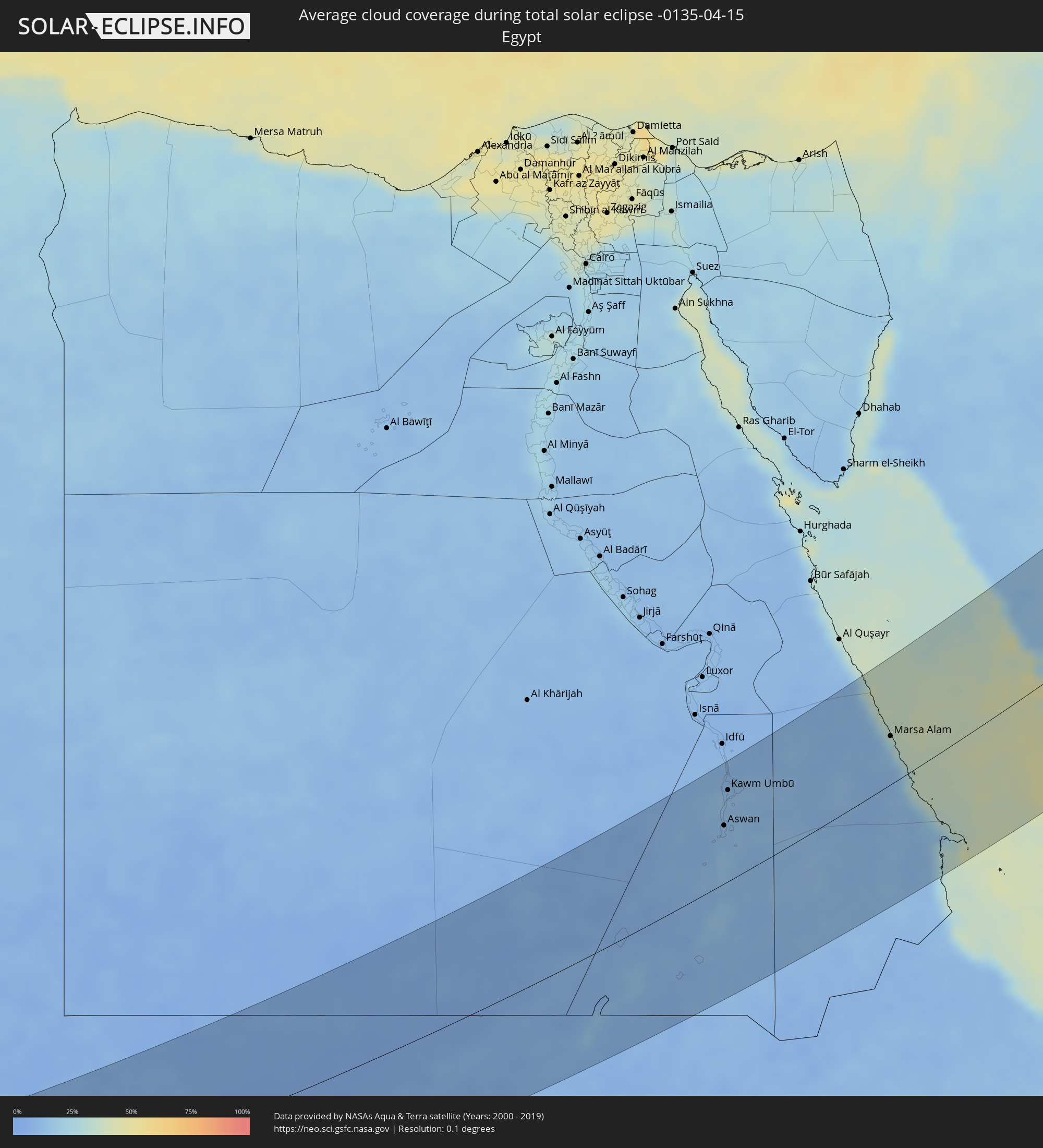 Egypt
Egypt
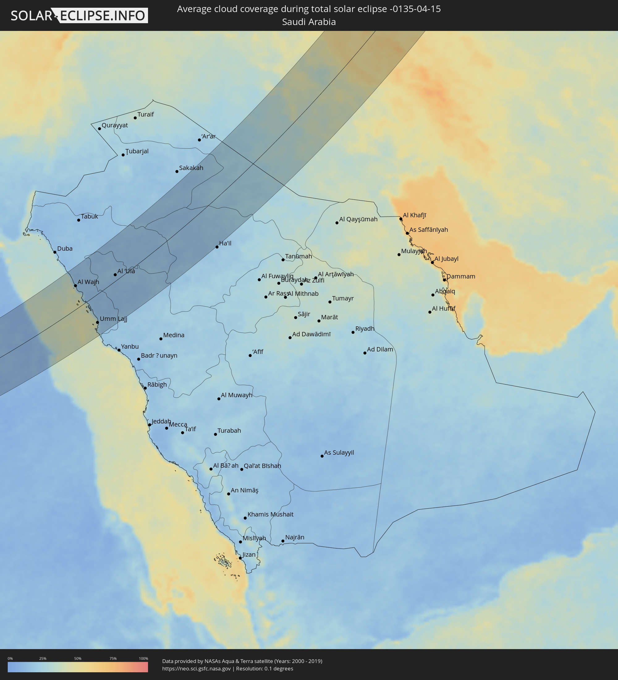 Saudi Arabia
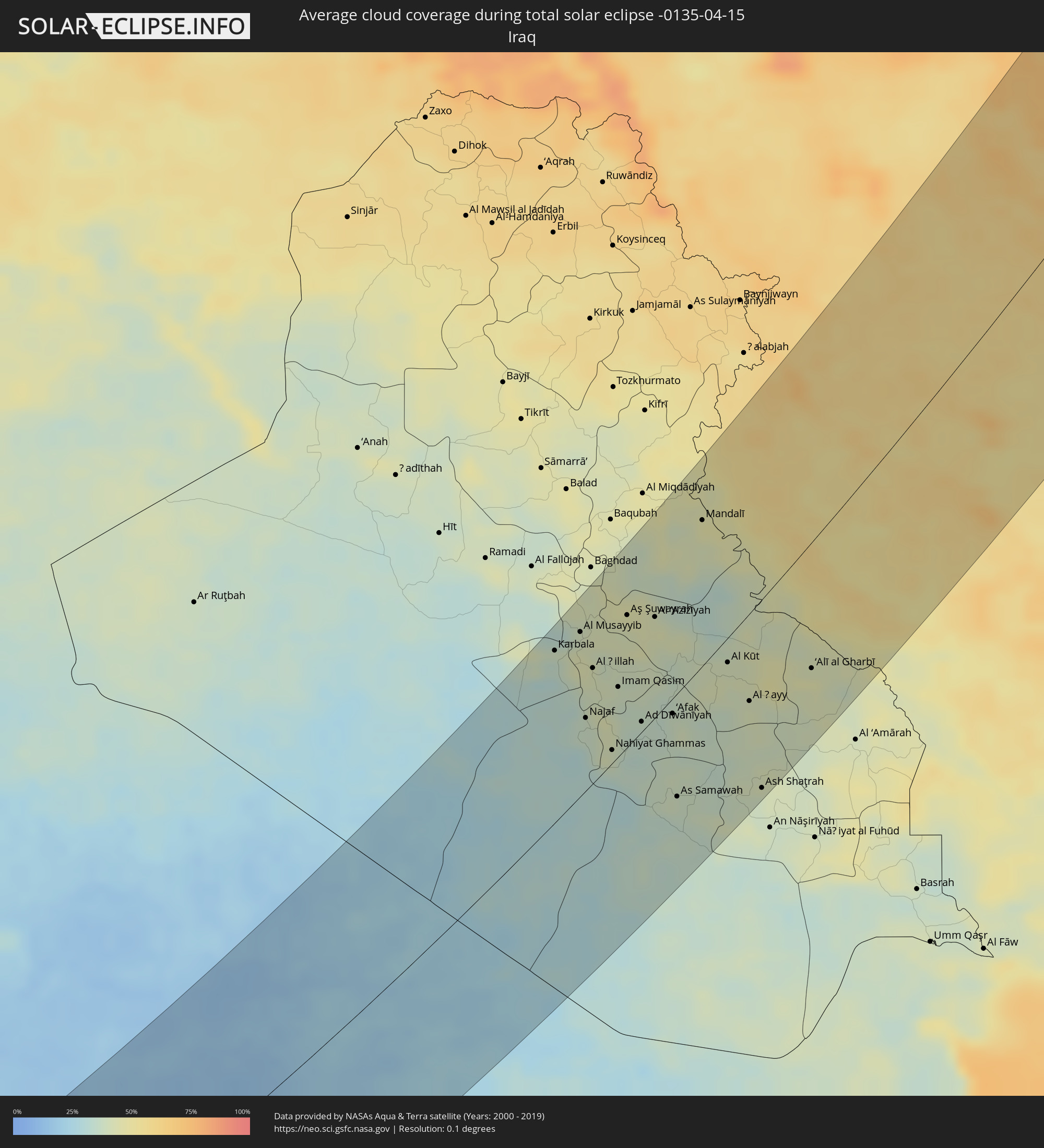 Iraq
Iraq
 Iran
Iran
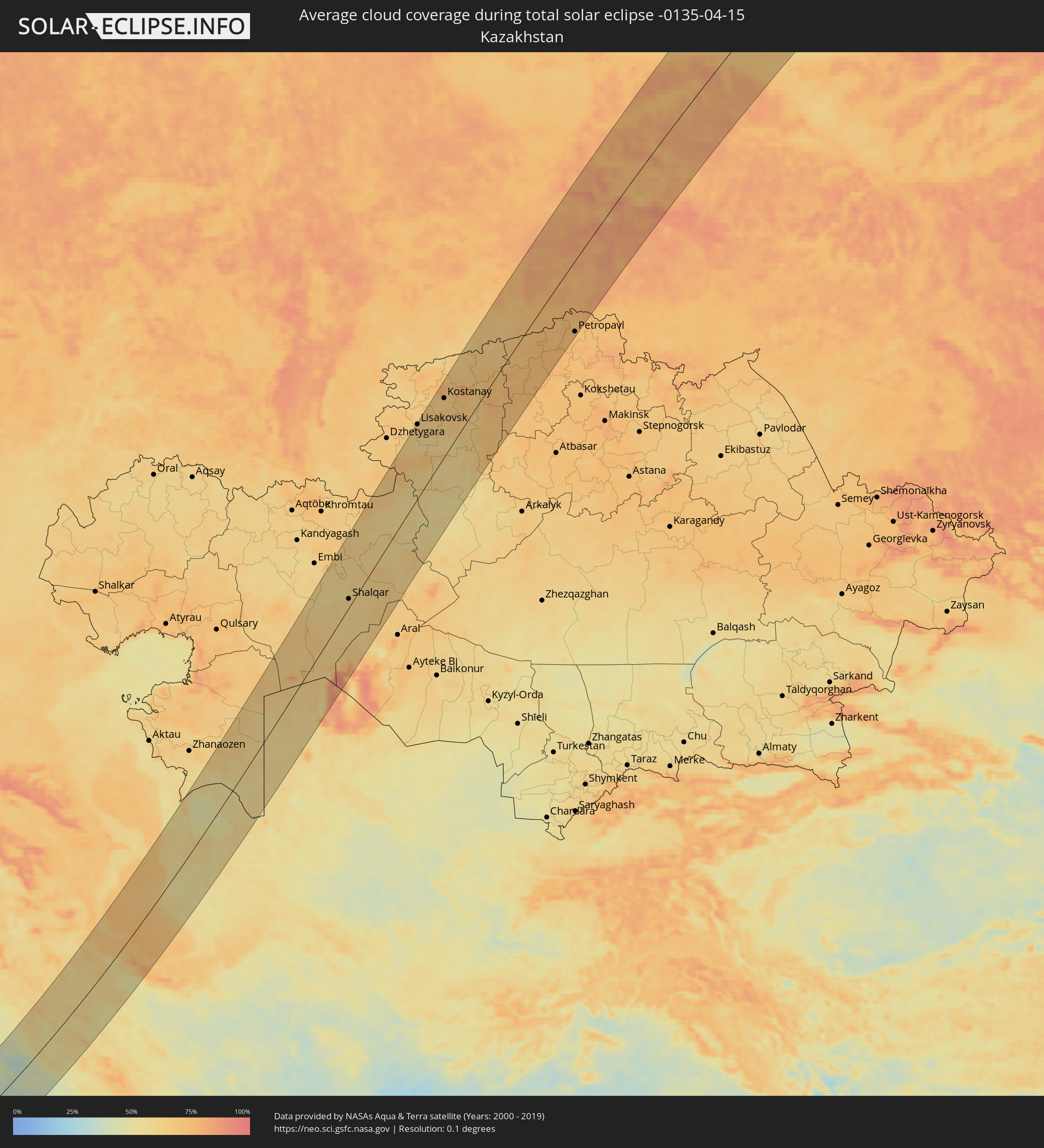 Kazakhstan
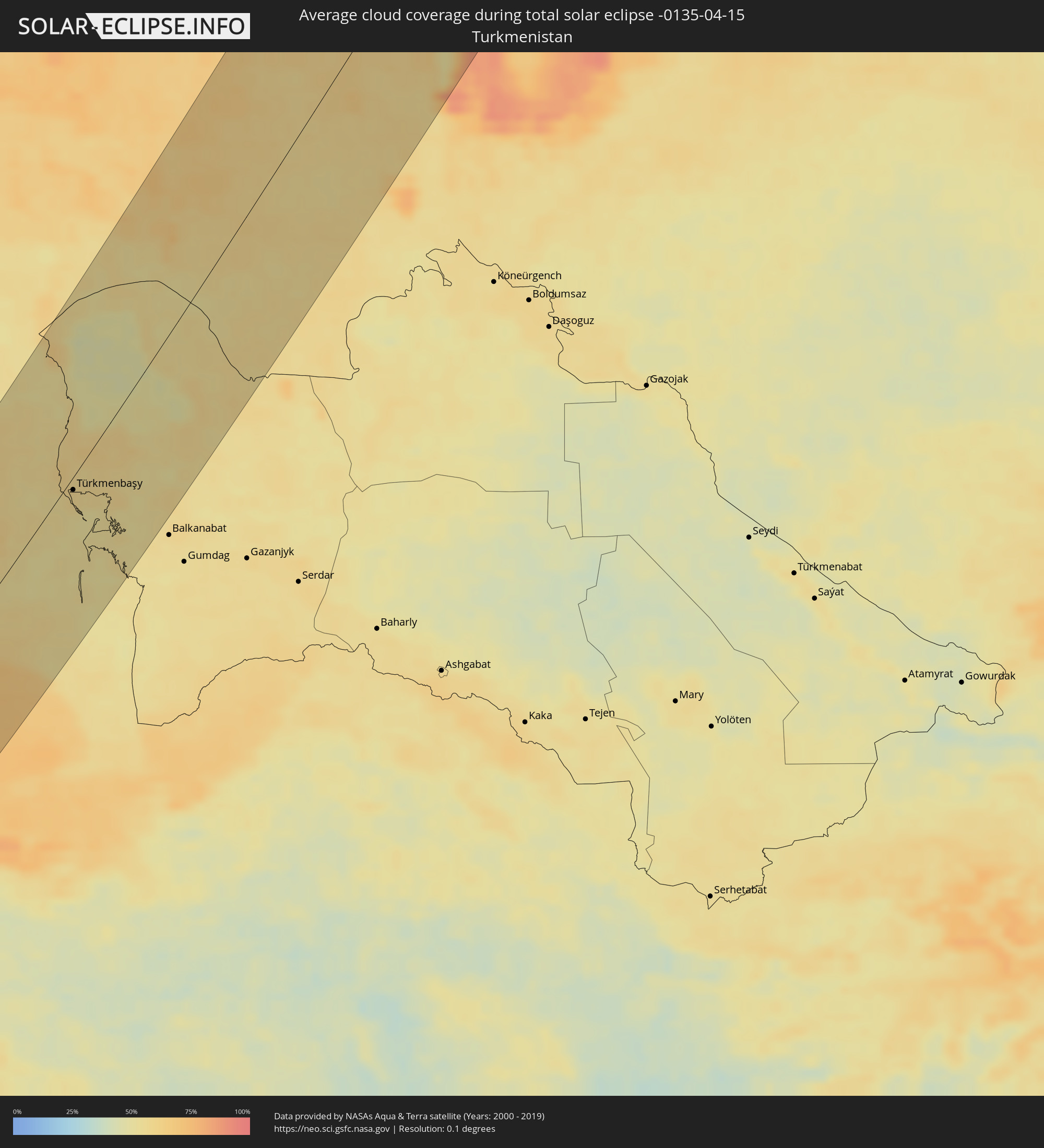 Turkmenistan
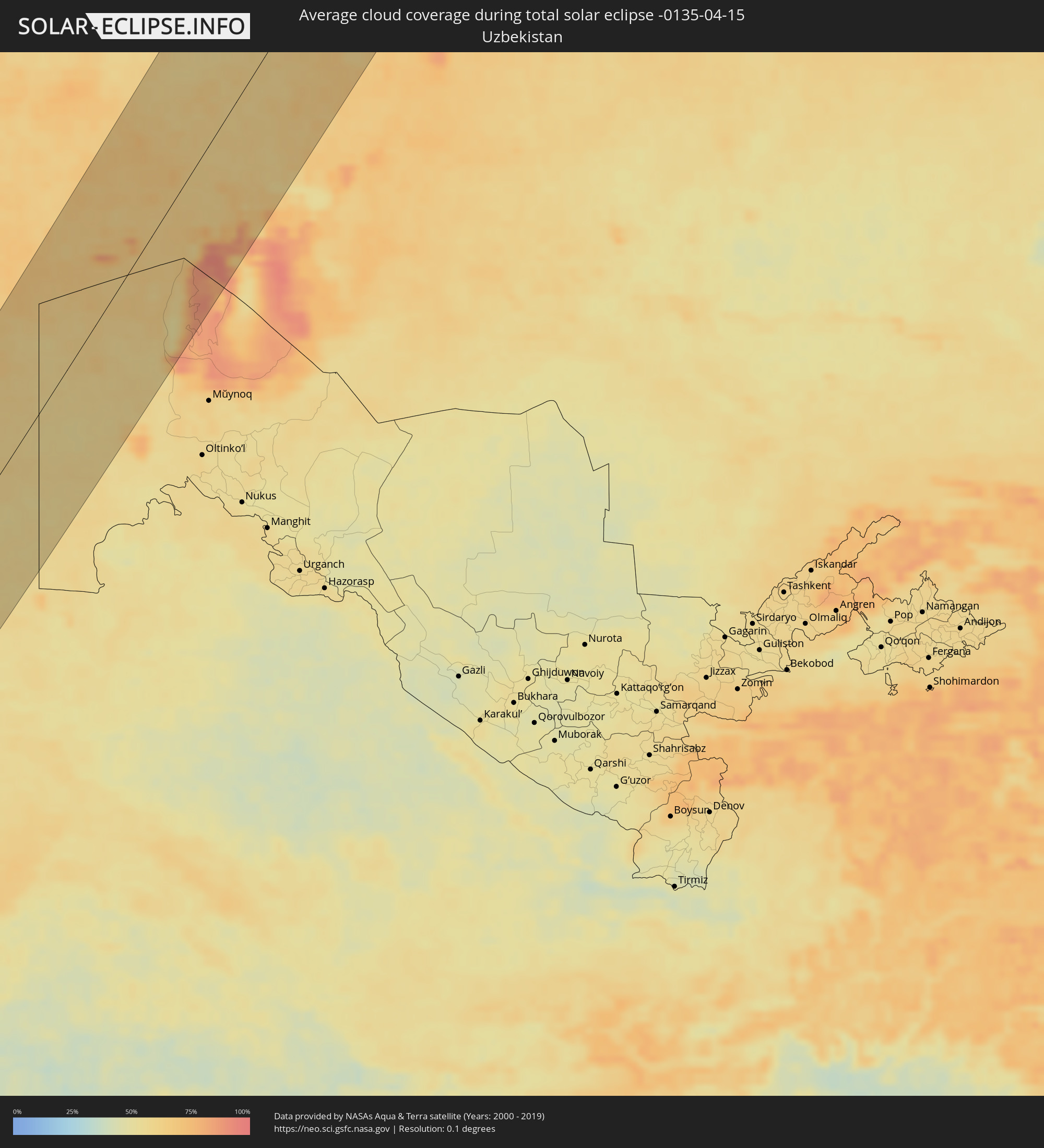 Uzbekistan
Cities inside the path of the eclipse
The following table shows all locations with a population of more than 5,000 inside the eclipse path. Cities which have more than 100,000 inhabitants are marked bold. A click at the locations opens a detailed map.
| City | Type | Eclipse duration | Local time of max. eclipse | Distance to central line | Ø Cloud coverage |
|
Faya-Largeau, Borkou
|
total | - | 05:54:19 UTC+01:00 | 61 km | 8% |
|
Aswan, Aswan
|
total | - | 07:05:27 UTC+02:00 | 61 km | 12% |
|
Kawm Umbū, Aswan
|
total | - | 07:06:07 UTC+02:00 | 96 km | 14% |
|
Marsa Alam, Red Sea
|
total | - | 07:07:52 UTC+02:00 | 49 km | 23% |
|
Al Wajh, Tabuk
|
total | - | 08:17:30 UTC+03:06 | 71 km | 28% |
|
Umm Lajj, Tabuk
|
total | - | 08:15:43 UTC+03:06 | 87 km | 26% |
|
Al ‘Ulá, Al Madīnah al Munawwarah
|
total | - | 08:18:52 UTC+03:06 | 18 km | 14% |
|
Karbala, Karbalāʼ
|
total | - | 08:24:37 UTC+02:57 | 116 km | 34% |
|
Al Hindīyah, Karbalāʼ
|
total | - | 08:24:38 UTC+02:57 | 97 km | 38% |
|
Nāḩīyat Saddat al Hindīyah, Bābil
|
total | - | 08:25:00 UTC+02:57 | 106 km | 42% |
|
Al Musayyib, Bābil
|
total | - | 08:25:08 UTC+02:57 | 110 km | 41% |
|
Najaf, An Najaf
|
total | - | 08:23:43 UTC+02:57 | 49 km | 37% |
|
Al Ḩillah, Bābil
|
total | - | 08:24:37 UTC+02:57 | 77 km | 41% |
|
Kufa, An Najaf
|
total | - | 08:23:50 UTC+02:57 | 45 km | 40% |
|
Al Mishkhāb, An Najaf
|
total | - | 08:23:24 UTC+02:57 | 23 km | 42% |
|
Ash Shāmīyah, Al Qādisīyah
|
total | - | 08:23:47 UTC+02:57 | 27 km | 41% |
|
Nahiyat Ghammas, Al Qādisīyah
|
total | - | 08:23:22 UTC+02:57 | 9 km | 37% |
|
Nāḩiyat ash Shināfīyah, Al Qādisīyah
|
total | - | 08:23:05 UTC+02:57 | 5 km | 33% |
|
Imam Qasim, Bābil
|
total | - | 08:24:29 UTC+02:57 | 47 km | 37% |
|
Aş Şuwayrah, Wāsiţ
|
total | - | 08:25:46 UTC+02:57 | 87 km | 42% |
|
Ad Dīwānīyah, Al Qādisīyah
|
total | - | 08:24:05 UTC+02:57 | 7 km | 35% |
|
Al ‘Azīzīyah, Wāsiţ
|
total | - | 08:25:57 UTC+02:57 | 66 km | 44% |
|
Ar Rumaythah, Al Muthanná
|
total | - | 08:23:23 UTC+02:57 | 48 km | 38% |
|
‘Afak, Al Qādisīyah
|
total | - | 08:24:27 UTC+02:57 | 10 km | 38% |
|
As Samawah, Al Muthanná
|
total | - | 08:23:05 UTC+02:57 | 69 km | 36% |
|
Mandalī, Diyālá
|
total | - | 08:27:57 UTC+02:57 | 93 km | 45% |
|
Al Kūt, Wāsiţ
|
total | - | 08:25:46 UTC+02:57 | 16 km | 41% |
|
Al Ḩayy, Wāsiţ
|
total | - | 08:25:16 UTC+02:57 | 57 km | 41% |
|
Ash Shaţrah, Dhi Qar
|
total | - | 08:23:53 UTC+02:57 | 124 km | 41% |
|
Īlām, Īlām
|
total | - | 08:56:33 UTC+03:25 | 25 km | 54% |
|
‘Alī al Gharbī, Maysan
|
total | - | 08:26:20 UTC+02:57 | 80 km | 45% |
|
Kāmyārān, Kordestān
|
total | - | 08:59:13 UTC+03:25 | 71 km | 56% |
|
Sanandaj, Kordestān
|
total | - | 09:00:17 UTC+03:25 | 103 km | 58% |
|
Kahrīz, Kermānshāh
|
total | - | 08:58:31 UTC+03:25 | 34 km | 59% |
|
Harsīn, Kermānshāh
|
total | - | 08:58:43 UTC+03:25 | 12 km | 59% |
|
Kūhdasht, Lorestān
|
total | - | 08:57:18 UTC+03:25 | 67 km | 55% |
|
Qorveh, Kordestān
|
total | - | 09:00:39 UTC+03:25 | 36 km | 57% |
|
Nūrābād, Lorestān
|
total | - | 08:58:39 UTC+03:25 | 53 km | 60% |
|
Asadābād, Hamadān
|
total | - | 09:00:10 UTC+03:25 | 14 km | 60% |
|
Khorramabad, Lorestān
|
total | - | 08:57:49 UTC+03:25 | 123 km | 56% |
|
Nahāvand, Hamadān
|
total | - | 08:59:13 UTC+03:25 | 73 km | 54% |
|
Pasragad Branch, Hamadān
|
total | - | 09:00:27 UTC+03:25 | 39 km | 62% |
|
Zanjān, Zanjan
|
total | - | 09:04:10 UTC+03:25 | 91 km | 63% |
|
Borūjerd, Lorestān
|
total | - | 08:58:57 UTC+03:25 | 121 km | 56% |
|
Malāyer, Hamadān
|
total | - | 08:59:48 UTC+03:25 | 98 km | 55% |
|
Alvand, Zanjan
|
total | - | 09:04:04 UTC+03:25 | 18 km | 60% |
|
Abhar, Zanjan
|
total | - | 09:03:46 UTC+03:25 | 3 km | 61% |
|
Bandar-e Anzalī, Gīlān
|
total | - | 09:06:35 UTC+03:25 | 75 km | 66% |
|
Rasht, Gīlān
|
total | - | 09:06:18 UTC+03:25 | 52 km | 71% |
|
Tākestān, Qazvīn
|
total | - | 09:04:02 UTC+03:25 | 37 km | 56% |
|
Qazvin, Qazvīn
|
total | - | 09:04:42 UTC+03:25 | 45 km | 54% |
|
Langarūd, Gīlān
|
total | - | 09:06:39 UTC+03:25 | 7 km | 70% |
|
Ābyek, Markazi
|
total | - | 09:04:47 UTC+03:25 | 98 km | 52% |
|
Naz̧arābād, Alborz
|
total | - | 09:04:37 UTC+03:25 | 109 km | 51% |
|
Chālūs, Māzandarān
|
total | - | 09:06:44 UTC+03:25 | 120 km | 68% |
|
Türkmenbaşy, Balkan
|
total | - | 09:42:32 UTC+03:53 | 9 km | 57% |
|
Shalqar, Aqtöbe
|
total | - | 09:35:28 UTC+03:25 | 15 km | 63% |
|
Svetlyy, Orenburg
|
total | - | 10:18:53 UTC+04:02 | 112 km | 66% |
|
Lisakovsk, Qostanay
|
total | - | 10:42:34 UTC+04:21 | 115 km | 63% |
|
Rudnyy, Qostanay
|
total | - | 10:43:50 UTC+04:21 | 105 km | 64% |
|
Torghay, Qostanay
|
total | - | 10:38:59 UTC+04:21 | 118 km | 60% |
|
Kostanay, Qostanay
|
total | - | 10:44:41 UTC+04:21 | 90 km | 63% |
|
Borovskoy, Qostanay
|
total | - | 10:46:06 UTC+04:21 | 93 km | 67% |
|
Qusmuryn, Qostanay
|
total | - | 10:44:33 UTC+04:21 | 12 km | 64% |
|
Vargashi, Kurgan
|
total | - | 10:30:37 UTC+04:02 | 97 km | 69% |
|
Lebyazh’ye, Kurgan
|
total | - | 10:31:08 UTC+04:02 | 57 km | 67% |
|
Novoishimskiy, Soltüstik Qazaqstan
|
total | - | 10:47:50 UTC+04:21 | 86 km | 72% |
|
Makushino, Kurgan
|
total | - | 10:31:47 UTC+04:02 | 14 km | 74% |
|
Sergeyevka, Soltüstik Qazaqstan
|
total | - | 10:49:27 UTC+04:21 | 78 km | 75% |
|
Omutinskiy, Tyumenskaya
|
total | - | 10:33:51 UTC+04:02 | 70 km | 77% |
|
Petukhovo, Kurgan
|
total | - | 10:32:14 UTC+04:02 | 30 km | 73% |
|
Golyshmanovo, Tyumenskaya
|
total | - | 10:34:26 UTC+04:02 | 30 km | 78% |
|
Bishkul, Soltüstik Qazaqstan
|
total | - | 10:52:22 UTC+04:21 | 111 km | 73% |
|
Petropavl, Soltüstik Qazaqstan
|
total | - | 10:52:32 UTC+04:21 | 108 km | 72% |
|
Kazanskoye, Tyumenskaya
|
total | - | 10:34:19 UTC+04:02 | 62 km | 74% |
|
Ishim, Tyumenskaya
|
total | - | 10:35:10 UTC+04:02 | 45 km | 77% |
|
Abatskoye, Tyumenskaya
|
total | - | 10:36:20 UTC+04:02 | 83 km | 80% |
|
Vikulovo, Tyumenskaya
|
total | - | 10:37:07 UTC+04:02 | 56 km | 84% |
|
Tevriz, Omsk
|
total | - | 11:30:37 UTC+04:53 | 97 km | 84% |
|
Pyt-Yakh, Khanty-Mansiyskiy Avtonomnyy Okrug
|
total | - | 10:43:29 UTC+04:02 | 98 km | 81% |
|
Barsovo, Khanty-Mansiyskiy Avtonomnyy Okrug
|
total | - | 10:44:09 UTC+04:02 | 113 km | 71% |
|
Poykovskiy, Khanty-Mansiyskiy Avtonomnyy Okrug
|
total | - | 10:44:22 UTC+04:02 | 110 km | 71% |
|
Surgut, Khanty-Mansiyskiy Avtonomnyy Okrug
|
total | - | 10:44:27 UTC+04:02 | 107 km | 76% |
|
Langepas, Khanty-Mansiyskiy Avtonomnyy Okrug
|
total | - | 10:46:01 UTC+04:02 | 32 km | 71% |
|
Pokachi, Khanty-Mansiyskiy Avtonomnyy Okrug
|
total | - | 10:46:34 UTC+04:02 | 57 km | 73% |
|
Megion, Khanty-Mansiyskiy Avtonomnyy Okrug
|
total | - | 10:46:37 UTC+04:02 | 22 km | 69% |
|
Nizhnevartovsk, Khanty-Mansiyskiy Avtonomnyy Okrug
|
total | - | 10:46:56 UTC+04:02 | 47 km | 69% |
|
Novoagansk, Khanty-Mansiyskiy Avtonomnyy Okrug
|
total | - | 10:47:52 UTC+04:02 | 20 km | 67% |
|
Izluchinsk, Khanty-Mansiyskiy Avtonomnyy Okrug
|
total | - | 10:47:18 UTC+04:02 | 59 km | 69% |
|
Raduzhny, Khanty-Mansiyskiy Avtonomnyy Okrug
|
total | - | 10:48:41 UTC+04:02 | 2 km | 67% |
|
Strezhevoy, Tomsk
|
total | - | 12:56:34 UTC+06:11 | 105 km | 69% |
|
Igarka, Krasnoyarskiy
|
total | - | 13:07:33 UTC+06:11 | 85 km | 67% |