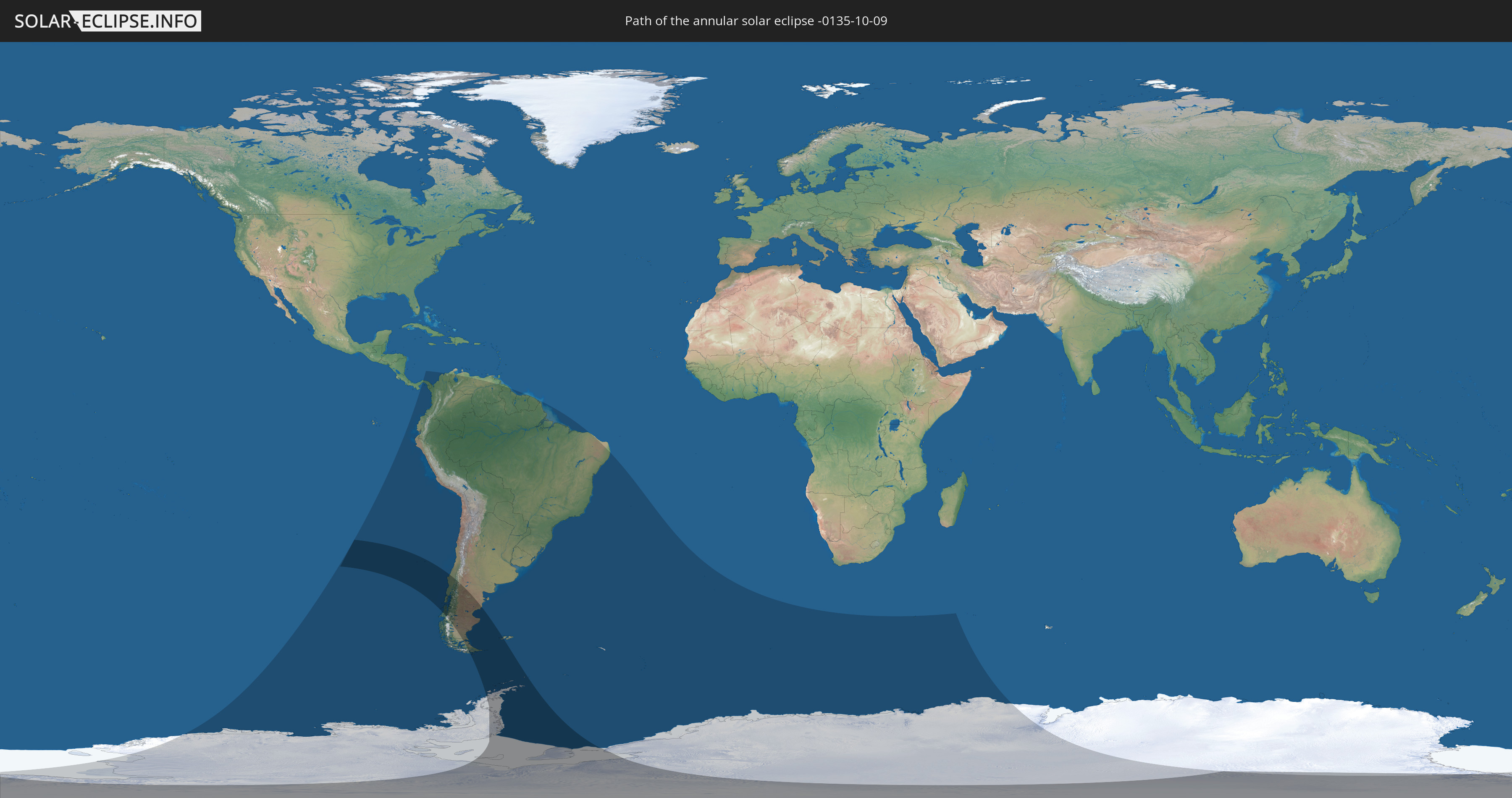
Annular solar eclipse of 10/09/-0135
| Day of week: | Saturday |
| Maximum duration of eclipse: | 07m02s |
| Maximum width of eclipse path: | 614 km |
| Saros cycle: | 80 |
| Coverage: | 91.8% |
| Magnitude: | 0.9177 |
| Gamma: | -0.868 |
Wo kann man die Sonnenfinsternis vom 10/09/-0135 sehen?
Die Sonnenfinsternis am 10/09/-0135 kann man in 19 Ländern als partielle Sonnenfinsternis beobachten.
Der Finsternispfad verläuft durch 4 Länder. Nur in diesen Ländern ist sie als annular Sonnenfinsternis zu sehen.
In den folgenden Ländern ist die Sonnenfinsternis annular zu sehen
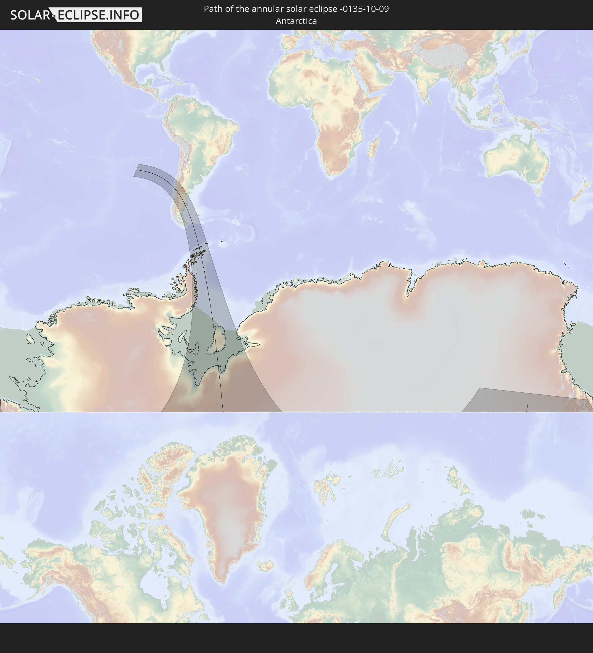 Antarctica
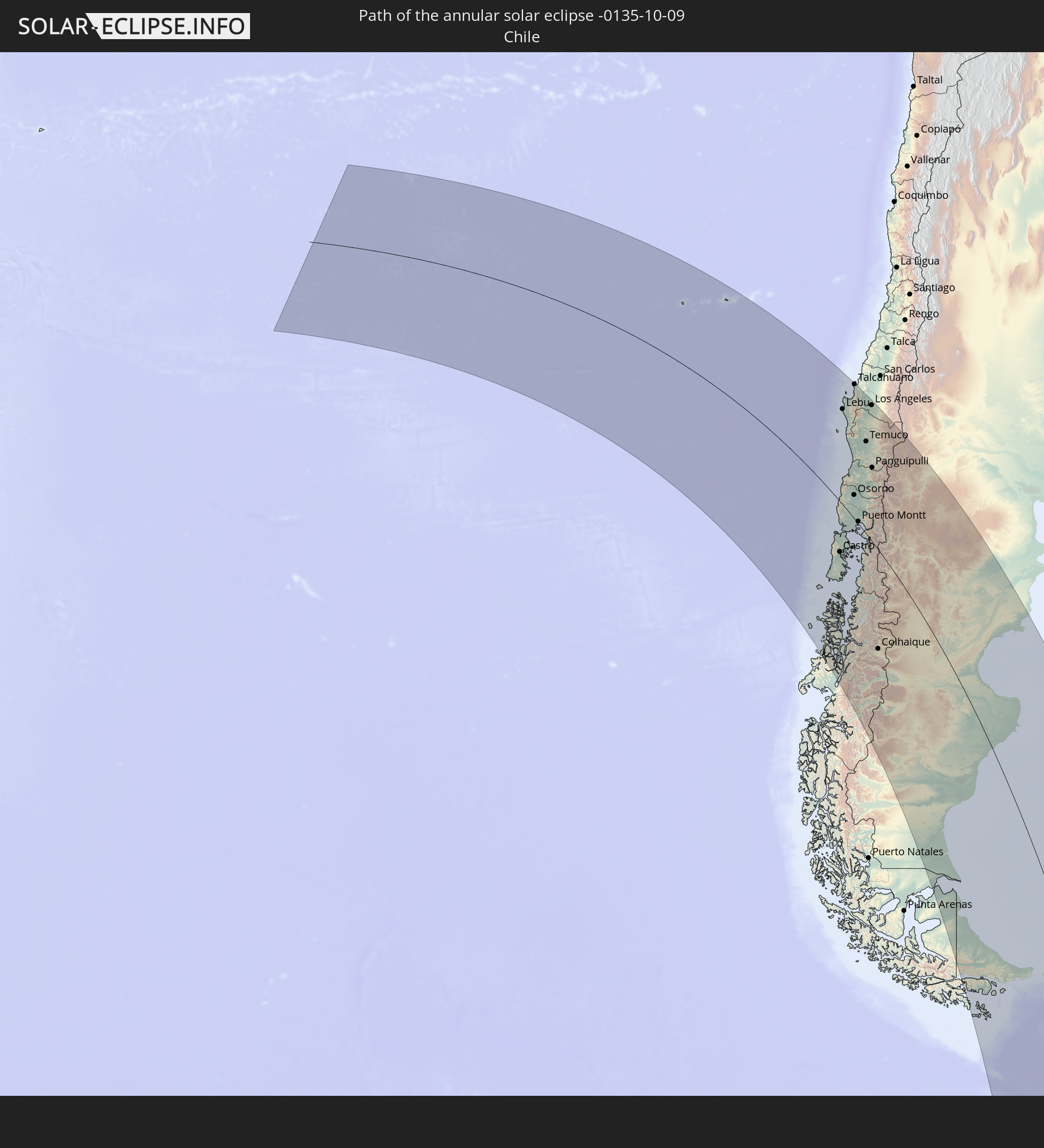 Chile
Chile
 Argentina
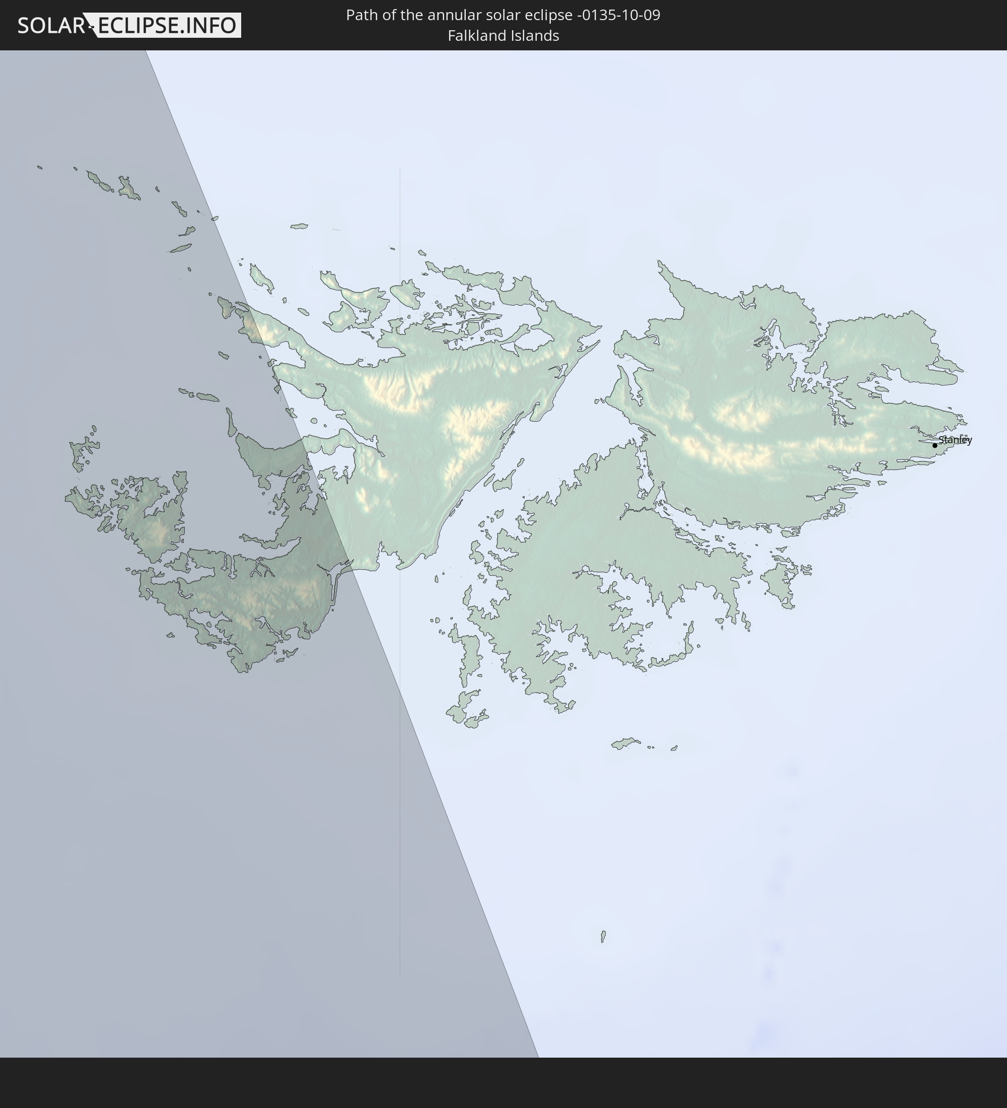 Falkland Islands
In den folgenden Ländern ist die Sonnenfinsternis partiell zu sehen


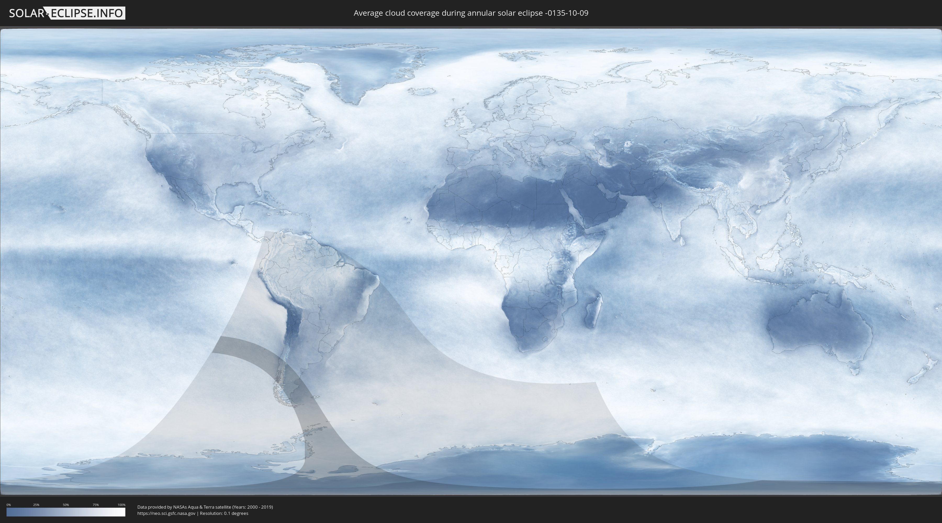
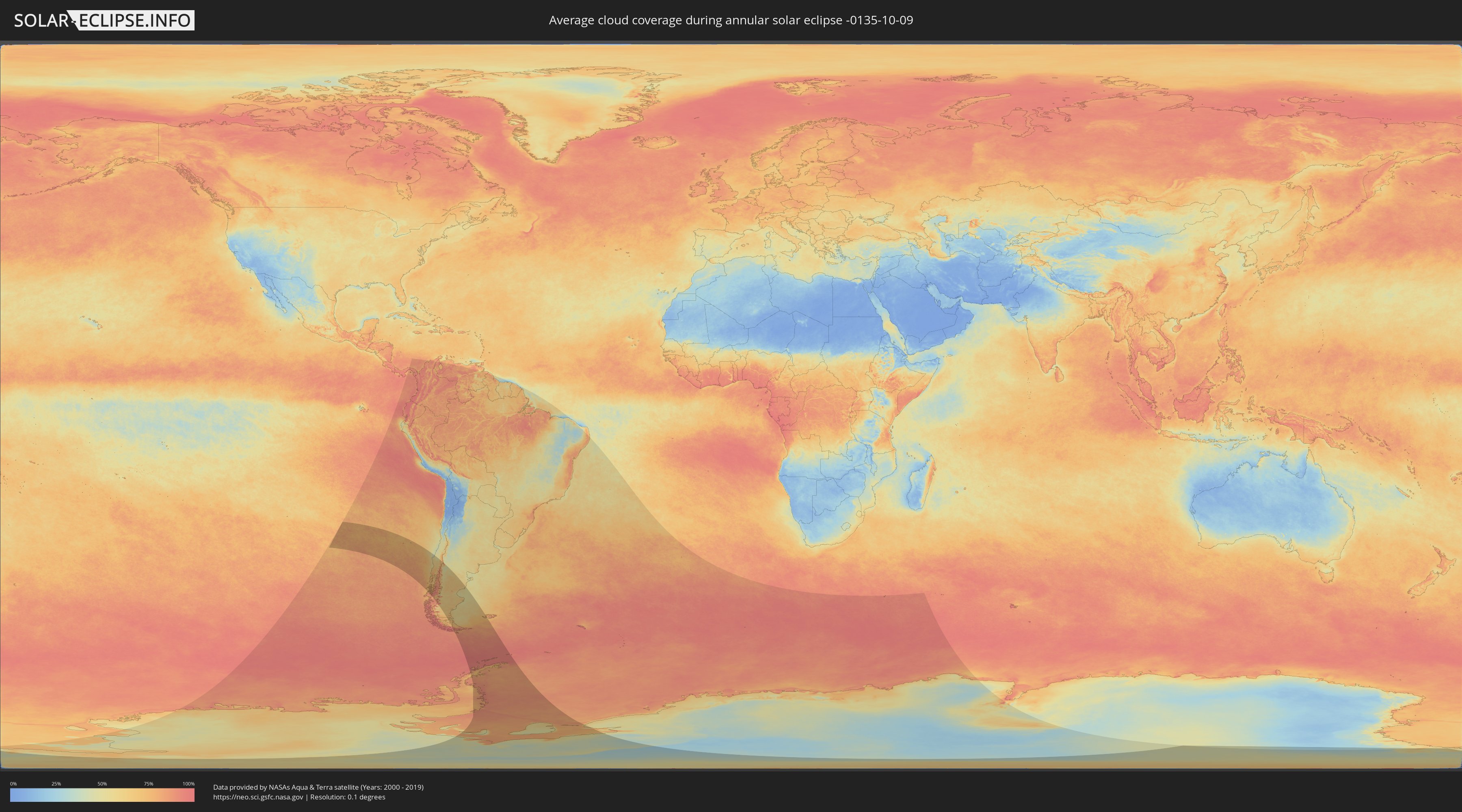
How will be the weather during the annular solar eclipse on 10/09/-0135?
Where is the best place to see the annular solar eclipse of 10/09/-0135?
The following maps show the average cloud coverage for the day of the annular solar eclipse.
With the help of these maps, it is possible to find the place along the eclipse path, which has the best
chance of a cloudless sky.
Nevertheless, you should consider local circumstances and inform about the weather of your chosen
observation site.
The data is provided by NASAs satellites
AQUA and TERRA.
The cloud maps are averaged over a period of 19 years (2000 - 2019).
Detailed country maps
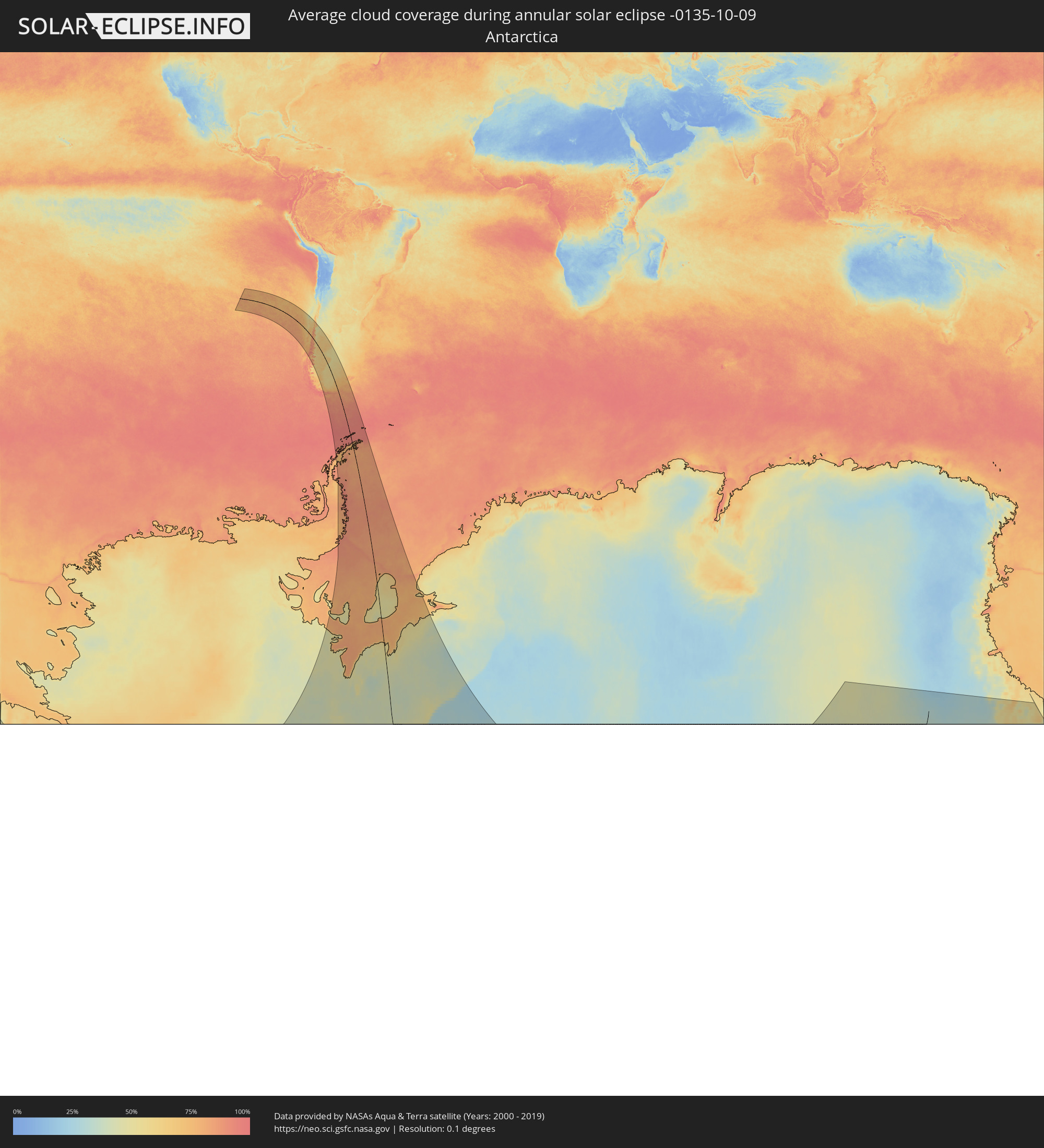 Antarctica
 Chile
Chile
 Argentina
 Falkland Islands
Cities inside the path of the eclipse
The following table shows all locations with a population of more than 5,000 inside the eclipse path. Cities which have more than 100,000 inhabitants are marked bold. A click at the locations opens a detailed map.
| City | Type | Eclipse duration | Local time of max. eclipse | Distance to central line | Ø Cloud coverage |
 Ancud, Los Lagos
|
annular | - | 07:49:18 UTC-04:42 | 80 km | 73% |
|
Chonchi, Los Lagos
|
annular | - | 07:50:59 UTC-04:42 | 127 km | 74% |
|
Castro, Los Lagos
|
annular | - | 07:50:40 UTC-04:42 | 119 km | 73% |
|
Lebu, Biobío
|
annular | - | 07:39:58 UTC-04:42 | 253 km | 57% |
|
Puerto Quellón, Los Lagos
|
annular | - | 07:52:12 UTC-04:42 | 151 km | 75% |
|
Cañete, Biobío
|
annular | - | 07:40:31 UTC-04:42 | 252 km | 59% |
|
Curanilahue, Biobío
|
annular | - | 07:39:50 UTC-04:42 | 282 km | 57% |
|
Arauco, Biobío
|
annular | - | 07:39:21 UTC-04:42 | 303 km | 50% |
|
Valdivia, Los Ríos
|
annular | - | 07:45:03 UTC-04:42 | 108 km | 63% |
|
Las Animas, Los Lagos
|
annular | - | 07:45:03 UTC-04:42 | 110 km | 63% |
|
Carahue, Araucanía
|
annular | - | 07:42:39 UTC-04:42 | 197 km | 64% |
|
Purranque, Los Lagos
|
annular | - | 07:47:33 UTC-04:42 | 32 km | 74% |
|
Lota, Biobío
|
annular | - | 07:39:05 UTC-04:42 | 325 km | 49% |
|
Coronel, Biobío
|
annular | - | 07:38:58 UTC-04:42 | 331 km | 52% |
|
Osorno, Los Lagos
|
annular | - | 07:46:48 UTC-04:42 | 60 km | 73% |
|
Calbuco, Los Lagos
|
annular | - | 07:49:29 UTC-04:42 | 33 km | 72% |
|
Talcahuano, Biobío
|
annular | - | 07:38:18 UTC-04:42 | 357 km | 48% |
|
La Unión, Los Ríos
|
annular | - | 07:46:12 UTC-04:42 | 85 km | 73% |
|
Concepción, Biobío
|
annular | - | 07:38:34 UTC-04:42 | 353 km | 52% |
|
Frutillar, Los Lagos
|
annular | - | 07:48:05 UTC-04:42 | 40 km | 68% |
|
Chiguayante, Biobío
|
annular | - | 07:38:48 UTC-04:42 | 347 km | 50% |
|
Puerto Varas, Los Lagos
|
annular | - | 07:48:33 UTC-04:42 | 20 km | 75% |
|
Río Bueno, Los Ríos
|
annular | - | 07:46:22 UTC-04:42 | 91 km | 73% |
|
Nueva Imperial, Araucanía
|
annular | - | 07:42:51 UTC-04:42 | 207 km | 62% |
|
Puerto Montt, Los Lagos
|
annular | - | 07:48:54 UTC-04:42 | 5 km | 69% |
|
Angol, Araucanía
|
annular | - | 07:40:53 UTC-04:42 | 295 km | 51% |
|
La Laja, Biobío
|
annular | - | 07:39:45 UTC-04:42 | 336 km | 46% |
|
Puerto Aisén, Aisén
|
annular | - | 07:57:51 UTC-04:42 | 228 km | 78% |
|
Nacimiento, Biobío
|
annular | - | 07:40:15 UTC-04:42 | 322 km | 52% |
|
Traiguén, Araucanía
|
annular | - | 07:41:54 UTC-04:42 | 262 km | 58% |
|
Pitrufquén, Araucanía
|
annular | - | 07:43:33 UTC-04:42 | 207 km | 63% |
|
Loncoche, Araucanía
|
annular | - | 07:44:24 UTC-04:42 | 180 km | 64% |
|
Freire, Araucanía
|
annular | - | 07:43:29 UTC-04:42 | 210 km | 63% |
|
Temuco, Araucanía
|
annular | - | 07:43:02 UTC-04:42 | 228 km | 65% |
|
Lautaro, Araucanía
|
annular | - | 07:42:40 UTC-04:42 | 254 km | 63% |
|
Collipulli, Araucanía
|
annular | - | 07:41:23 UTC-04:42 | 300 km | 57% |
|
Los Ángeles, Biobío
|
annular | - | 07:40:22 UTC-04:42 | 343 km | 49% |
|
Victoria, Araucanía
|
annular | - | 07:42:04 UTC-04:42 | 285 km | 61% |
|
Panguipulli, Araucanía
|
annular | - | 07:45:12 UTC-04:42 | 177 km | 61% |
|
Mulchén, Biobío
|
annular | - | 07:40:59 UTC-04:42 | 330 km | 51% |
|
Villarrica, Araucanía
|
annular | - | 07:44:27 UTC-04:42 | 210 km | 62% |
|
Vilcún, Araucanía
|
annular | - | 07:43:05 UTC-04:42 | 257 km | 64% |
|
Coihaique, Aisén
|
annular | - | 07:58:37 UTC-04:42 | 192 km | 73% |
|
Pucón, Araucanía
|
annular | - | 07:44:37 UTC-04:42 | 228 km | 68% |
 Villa La Angostura, Neuquén Province
|
annular | - | 08:14:04 UTC-04:16 | 140 km | 65% |
|
El Bolsón, Río Negro Province
|
annular | - | 08:16:49 UTC-04:16 | 68 km | 68% |
|
Trevelin, Chubut Province
|
annular | - | 08:19:23 UTC-04:16 | 12 km | 61% |
|
San Martín de los Andes, Neuquén Province
|
annular | - | 08:12:53 UTC-04:16 | 203 km | 81% |
|
Esquel, Chubut Province
|
annular | - | 08:19:05 UTC-04:16 | 17 km | 65% |
|
San Carlos de Bariloche, Río Negro Province
|
annular | - | 08:15:08 UTC-04:16 | 135 km | 56% |
|
Junín de los Andes, Neuquén Province
|
annular | - | 08:12:36 UTC-04:16 | 237 km | 50% |
|
Ingeniero Jacobacci, Río Negro Province
|
annular | - | 08:16:40 UTC-04:16 | 239 km | 58% |
|
Río Gallegos, Santa Cruz Province
|
annular | - | 08:39:53 UTC-04:16 | 273 km | 71% |
|
Sarmiento, Chubut Province
|
annular | - | 08:26:36 UTC-04:16 | 32 km | 66% |
|
Las Heras, Santa Cruz Province
|
annular | - | 08:28:49 UTC-04:16 | 34 km | 64% |
|
Ushuaia, Tierra del Fuego Province
|
annular | - | 08:47:21 UTC-04:16 | 317 km | 85% |
|
Pico Truncado, Santa Cruz Province
|
annular | - | 08:30:05 UTC-04:16 | 43 km | 62% |
|
San Julián, Santa Cruz Province
|
annular | - | 08:35:50 UTC-04:16 | 89 km | 61% |
|
Rada Tilly, Chubut Province
|
annular | - | 12:45:16 UTC+00:00 | 98 km | 57% |
|
Caleta Olivia, Santa Cruz Province
|
annular | - | 08:29:36 UTC-04:16 | 75 km | 57% |
|
Comodoro Rivadavia, Chubut Province
|
annular | - | 08:28:20 UTC-04:16 | 106 km | 57% |
|
Puerto Deseado, Santa Cruz Province
|
annular | - | 08:33:45 UTC-04:16 | 121 km | 56% |