Total solar eclipse of 05/24/-0258
| Day of week: | Tuesday |
| Maximum duration of eclipse: | 05m37s |
| Maximum width of eclipse path: | 263 km |
| Saros cycle: | 72 |
| Coverage: | 100% |
| Magnitude: | 1.0605 |
| Gamma: | -0.6568 |
Wo kann man die Sonnenfinsternis vom 05/24/-0258 sehen?
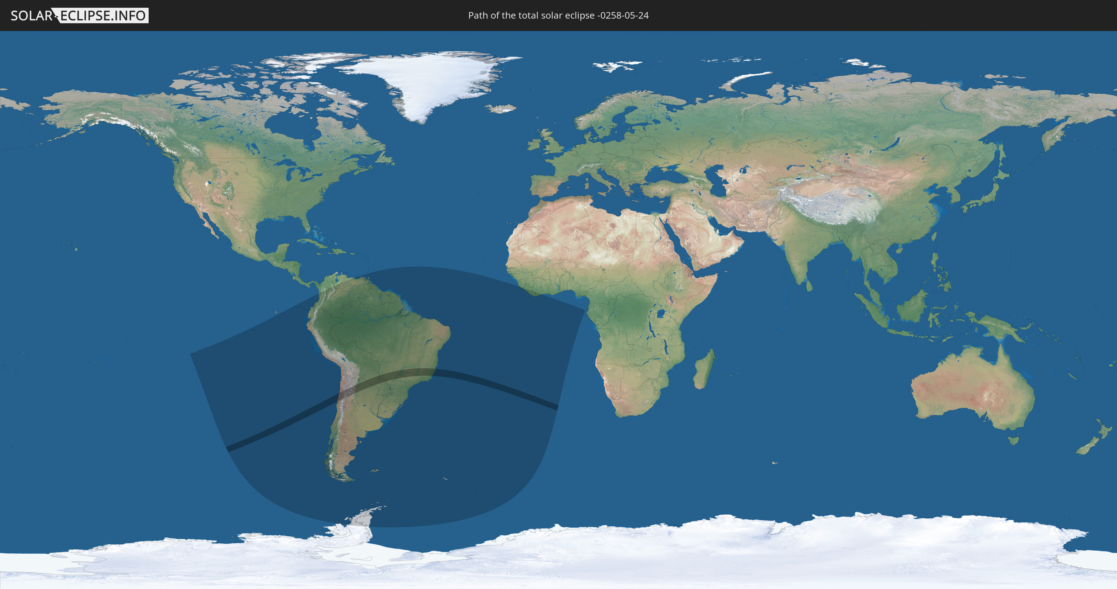
Die Sonnenfinsternis am 05/24/-0258 kann man in 23 Ländern als partielle Sonnenfinsternis beobachten.
Der Finsternispfad verläuft durch 4 Länder. Nur in diesen Ländern ist sie als total Sonnenfinsternis zu sehen.
In den folgenden Ländern ist die Sonnenfinsternis total zu sehen
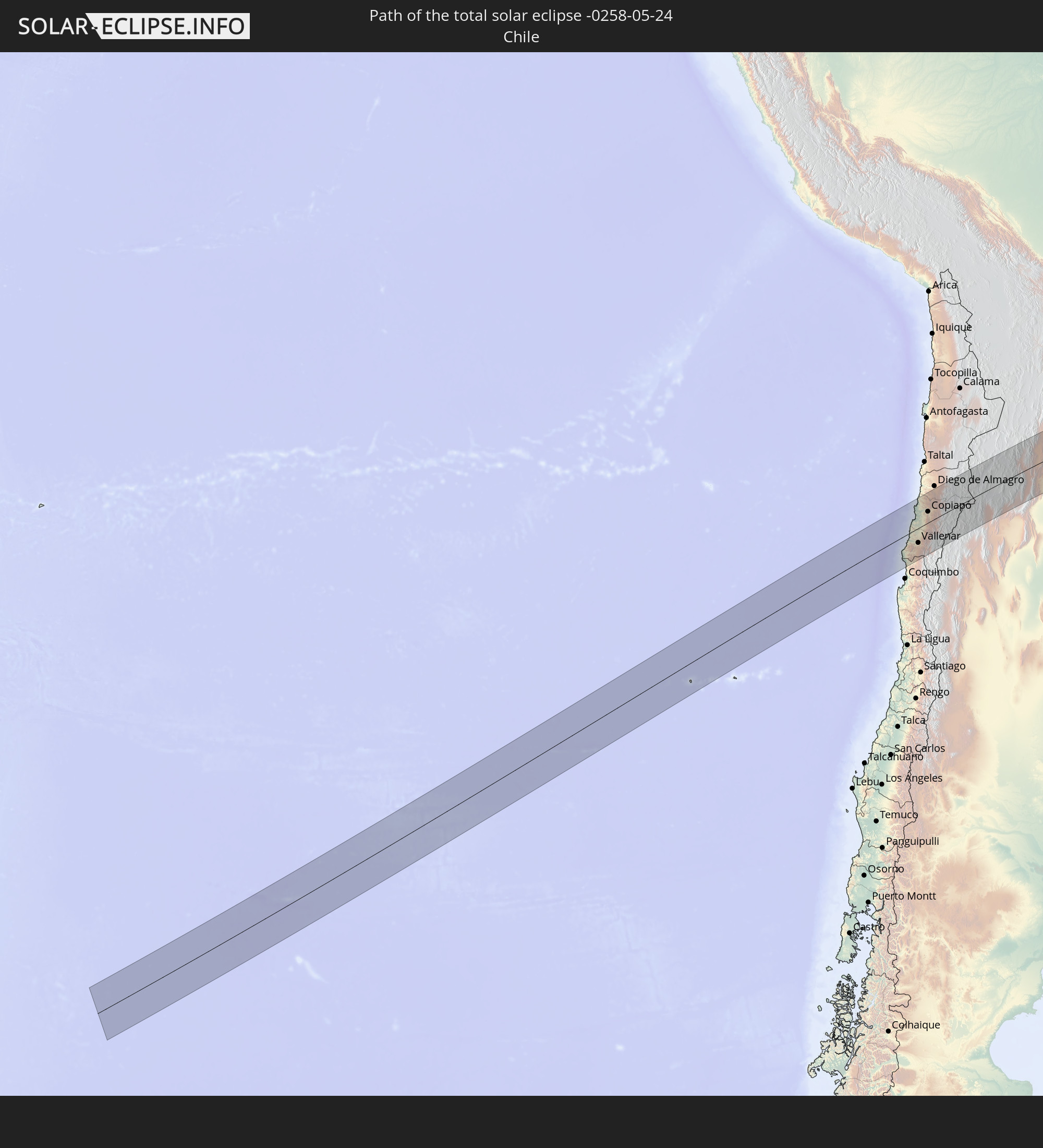 Chile
Chile
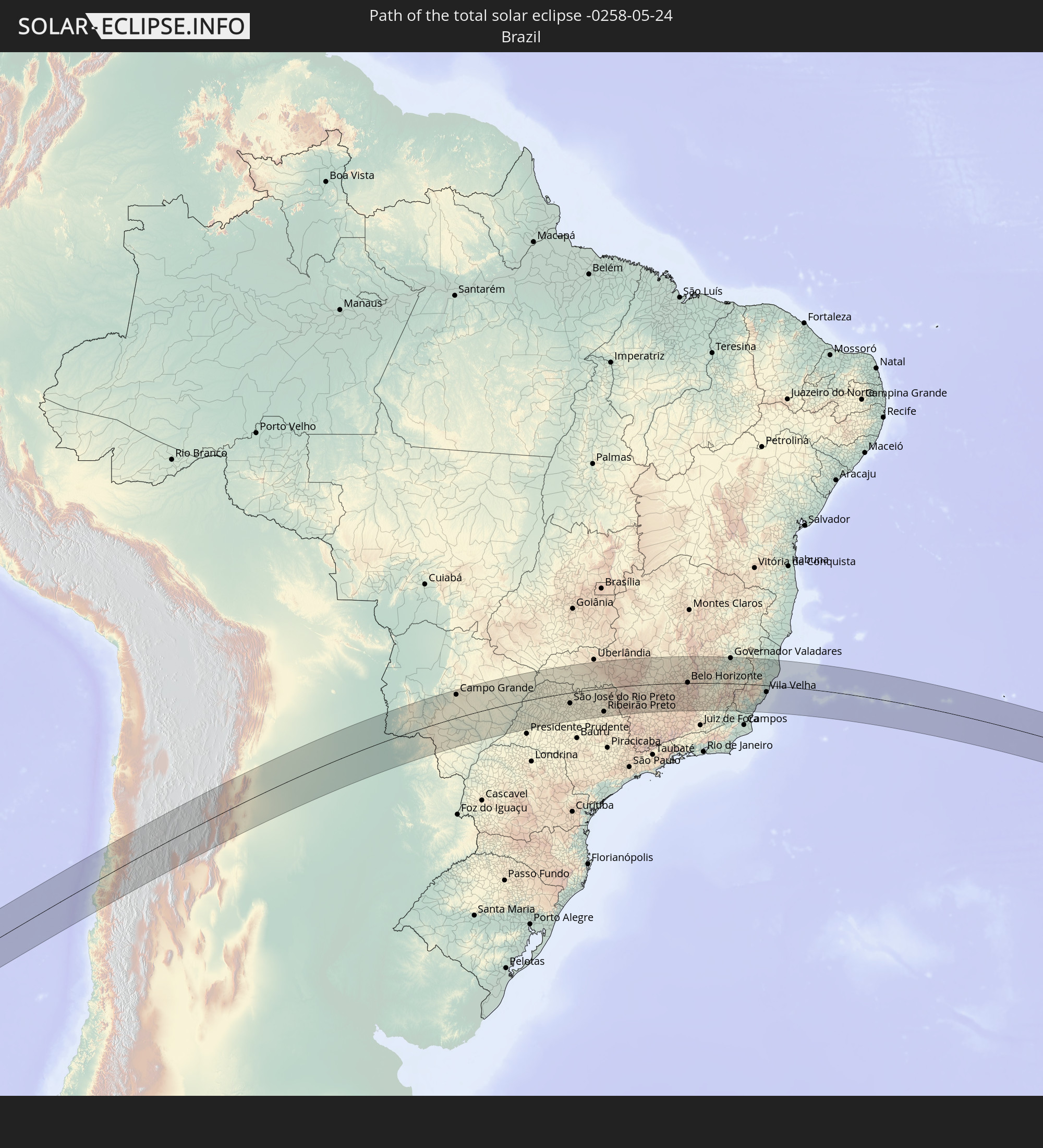 Brazil
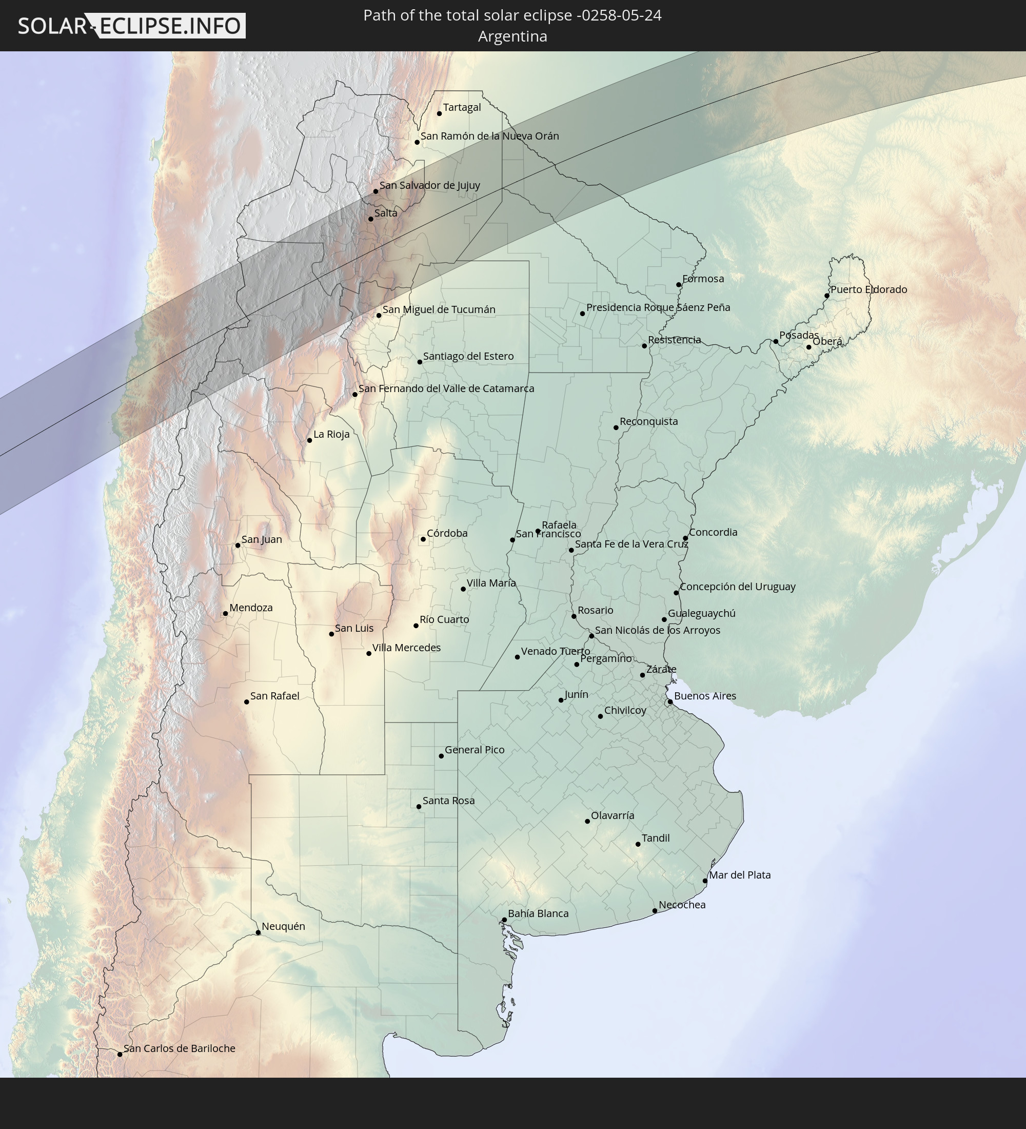 Argentina
 Paraguay
In den folgenden Ländern ist die Sonnenfinsternis partiell zu sehen
 Antarctica
 Chile
Chile
 Ecuador
 Colombia
 Peru
Peru
 Brazil
 Argentina
 Venezuela
 Bolivia
 Paraguay
 Trinidad and Tobago
 Falkland Islands
 Guyana
 Uruguay
 Suriname
 French Guiana
 South Georgia and the South Sandwich Islands
 Saint Helena, Ascension and Tristan da Cunha
 Sierra Leone
 Liberia
 Ivory Coast
 Equatorial Guinea
 São Tomé and Príncipe
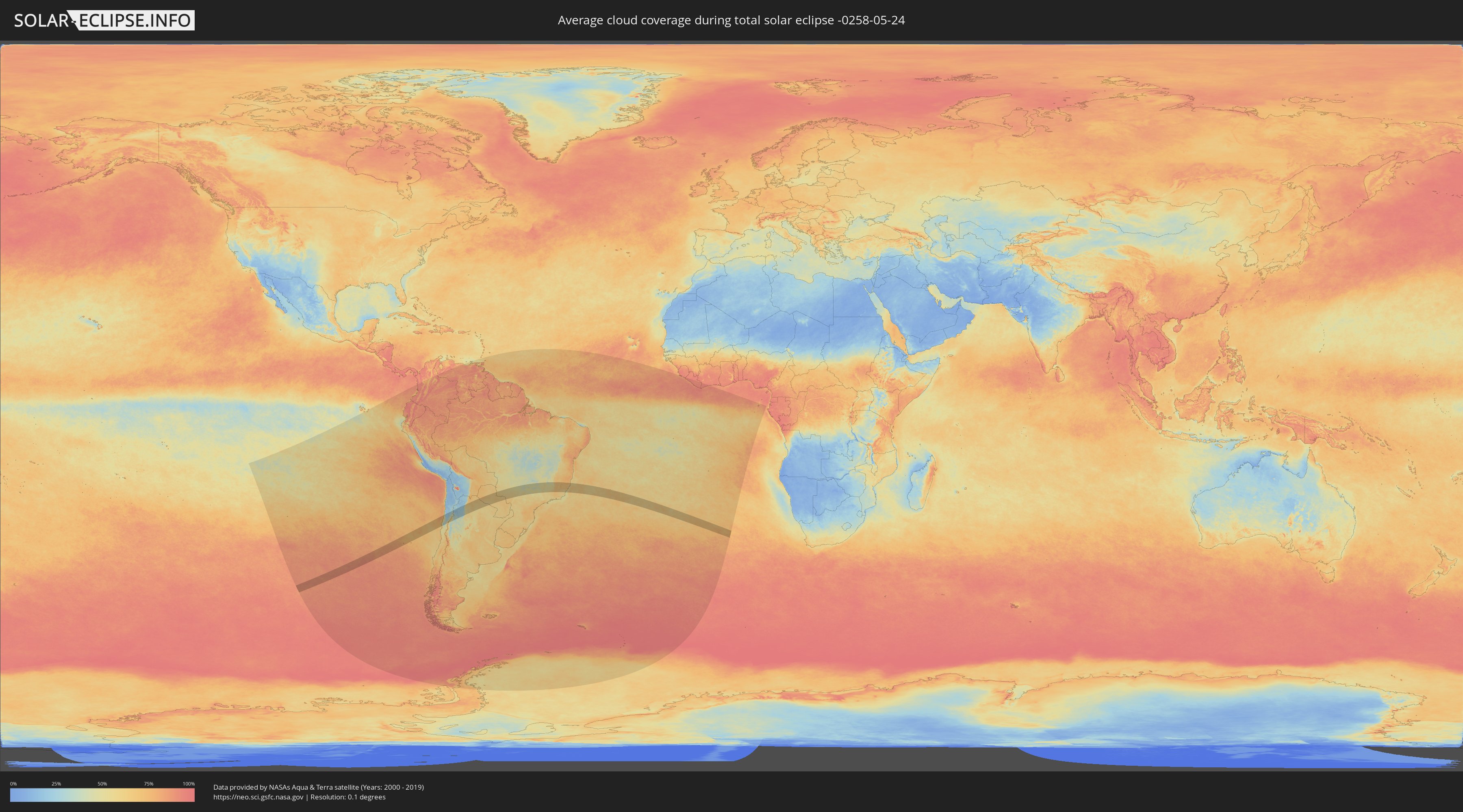
How will be the weather during the total solar eclipse on 05/24/-0258?
Where is the best place to see the total solar eclipse of 05/24/-0258?
The following maps show the average cloud coverage for the day of the total solar eclipse.
With the help of these maps, it is possible to find the place along the eclipse path, which has the best
chance of a cloudless sky.
Nevertheless, you should consider local circumstances and inform about the weather of your chosen
observation site.
The data is provided by NASAs satellites
AQUA and TERRA.
The cloud maps are averaged over a period of 19 years (2000 - 2019).

Detailed country maps
 Chile
Chile
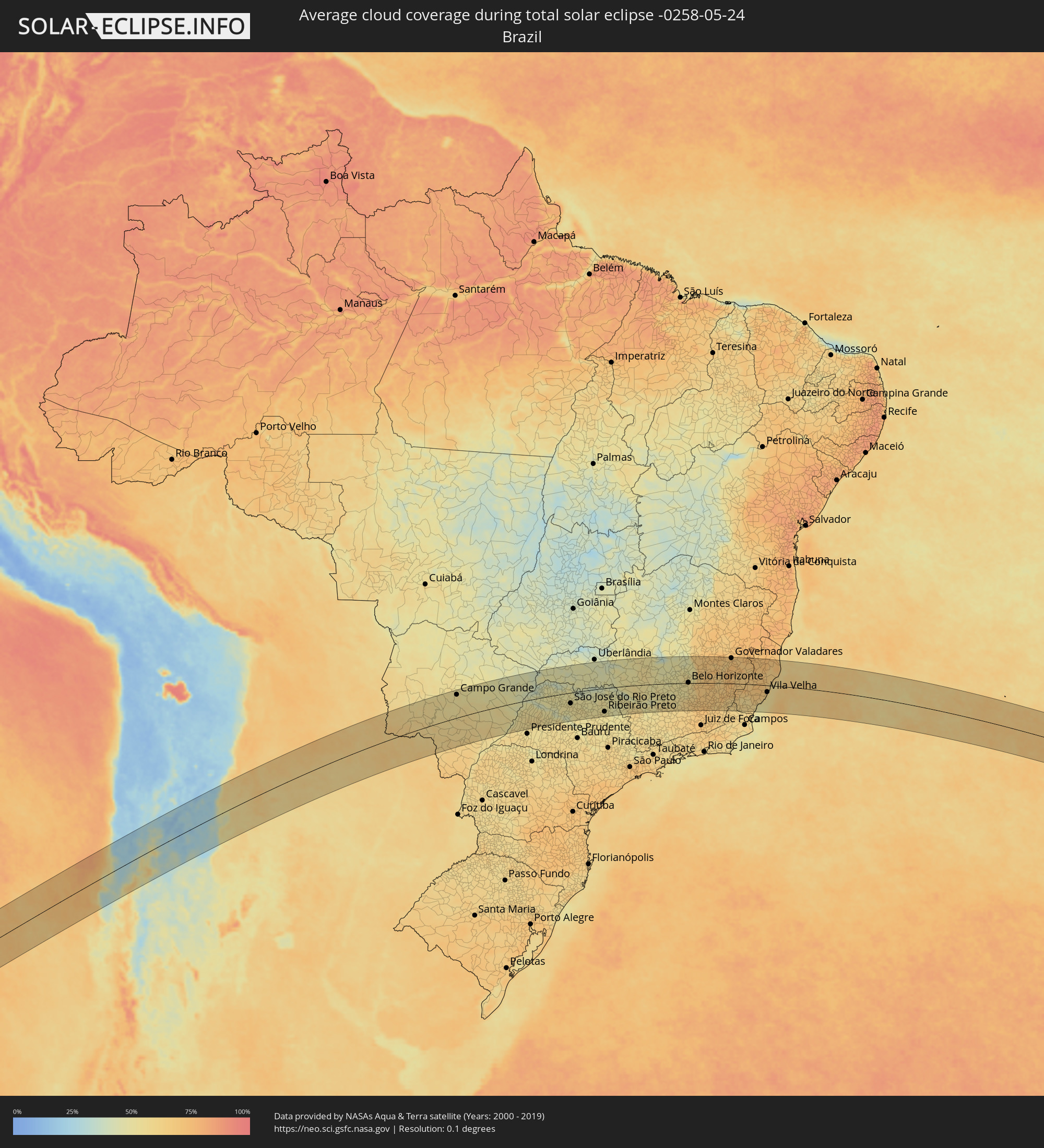 Brazil
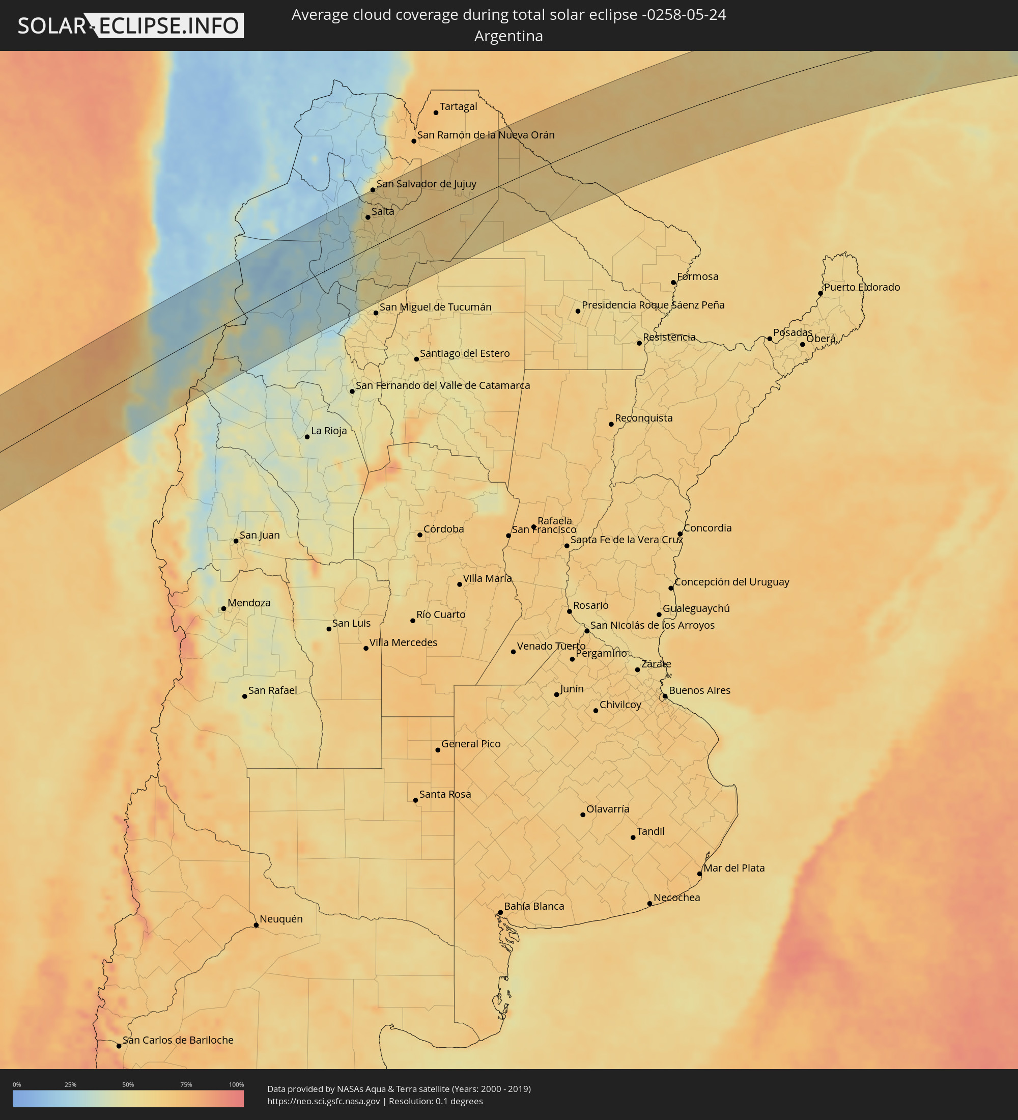 Argentina
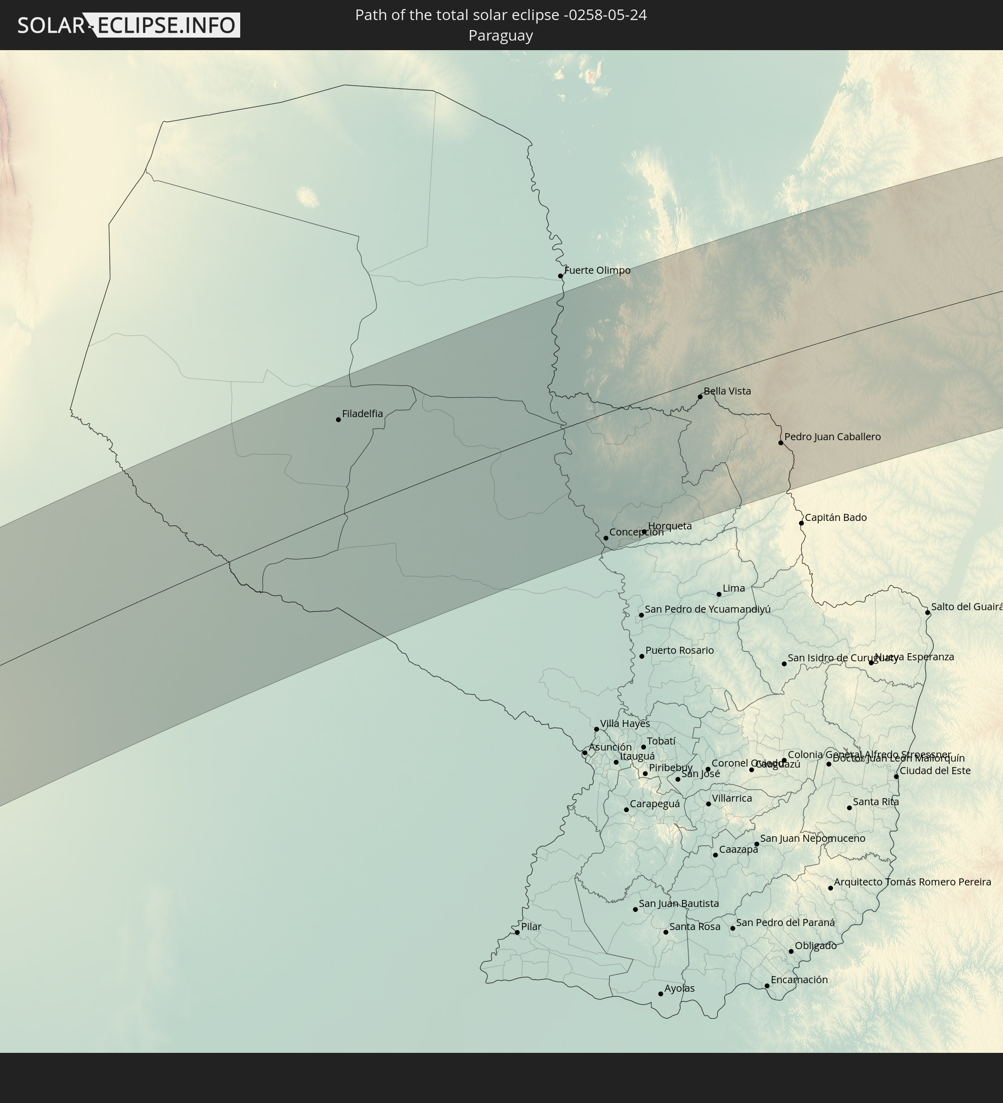
 Paraguay
Cities inside the path of the eclipse
The following table shows all locations with a population of more than 5,000 inside the eclipse path. Cities which have more than 100,000 inhabitants are marked bold. A click at the locations opens a detailed map.
| City | Type | Eclipse duration | Local time of max. eclipse | Distance to central line | Ø Cloud coverage |
|
Vallenar, Atacama
|
total | - | 10:11:52 UTC-04:42 | 55 km | 43% |
|
Copiapó, Atacama
|
total | - | 10:12:46 UTC-04:42 | 42 km | 33% |
|
Fiambalá, Catamarca Province
|
total | - | 10:44:30 UTC-04:16 | 119 km | 34% |
|
Cafayate, Salta Province
|
total | - | 10:48:27 UTC-04:16 | 36 km | 33% |
|
Chicoana, Salta Province
|
total | - | 10:49:42 UTC-04:16 | 40 km | 53% |
|
El Carril, Salta Province
|
total | - | 10:49:48 UTC-04:16 | 41 km | 53% |
|
Salta, Salta Province
|
total | - | 10:50:03 UTC-04:16 | 66 km | 60% |
|
San Salvador de Jujuy, Jujuy Province
|
total | - | 10:50:29 UTC-04:16 | 120 km | 59% |
|
Trancas, Tucumán Province
|
total | - | 10:50:03 UTC-04:16 | 82 km | 51% |
|
Palpalá, Jujuy Province
|
total | - | 10:50:40 UTC-04:16 | 110 km | 61% |
|
San Pedro, Jujuy Province
|
total | - | 10:51:31 UTC-04:16 | 97 km | 60% |
|
Ingenio La Esperanza, Jujuy Province
|
total | - | 10:51:35 UTC-04:16 | 96 km | 62% |
|
El Galpón, Salta Province
|
total | - | 10:51:44 UTC-04:16 | 28 km | 59% |
|
Palma Sola, Jujuy Province
|
total | - | 10:52:58 UTC-04:16 | 99 km | 64% |
|
Las Lajitas, Salta Province
|
total | - | 10:52:53 UTC-04:16 | 24 km | 59% |
|
Joaquín V. González, Salta Province
|
total | - | 10:52:57 UTC-04:16 | 19 km | 60% |
|
El Quebrachal, Salta Province
|
total | - | 10:53:11 UTC-04:16 | 44 km | 60% |
|
Apolinario Saravia, Salta Province
|
total | - | 10:53:35 UTC-04:16 | 38 km | 64% |
|
Taco Pozo, Chaco Province
|
total | - | 10:55:01 UTC-04:16 | 112 km | 58% |
|
Ingeniero Guillermo N. Juárez, Formosa Province
|
total | - | 10:59:09 UTC-04:16 | 1 km | 60% |
|
Filadelfia, Boquerón
|
total | - | 11:30:40 UTC-03:50 | 88 km | 67% |
|
Colonia Menno, Boquerón
|
total | - | 11:31:14 UTC-03:50 | 77 km | 66% |
|
Concepción, Concepción
|
total | - | 11:37:17 UTC-03:50 | 118 km | 63% |
|
Horqueta, Concepción
|
total | - | 11:38:20 UTC-03:50 | 125 km | 61% |
|
Bella Vista, Amambay
|
total | - | 11:40:25 UTC-03:50 | 16 km | 58% |
|
Pedro Juan Caballero, Amambay
|
total | - | 11:42:25 UTC-03:50 | 85 km | 62% |
|
Ponta Porã, Mato Grosso do Sul
|
total | - | 11:54:39 UTC-03:38 | 84 km | 62% |
|
Dourados, Mato Grosso do Sul
|
total | - | 11:57:24 UTC-03:38 | 79 km | 59% |
|
Campo Grande, Mato Grosso do Sul
|
total | - | 11:58:49 UTC-03:38 | 107 km | 55% |
|
Três Lagoas, Mato Grosso do Sul
|
total | - | 12:07:07 UTC-03:38 | 3 km | 47% |
|
Araçatuba, São Paulo
|
total | - | 12:42:31 UTC-03:06 | 75 km | 53% |
|
Fernandópolis, São Paulo
|
total | - | 12:43:38 UTC-03:06 | 23 km | 49% |
|
Penápolis, São Paulo
|
total | - | 12:43:25 UTC-03:06 | 105 km | 53% |
|
Votuporanga, São Paulo
|
total | - | 12:44:20 UTC-03:06 | 3 km | 50% |
|
São José do Rio Preto, São Paulo
|
total | - | 12:45:48 UTC-03:06 | 51 km | 52% |
|
Catanduva, São Paulo
|
total | - | 12:46:46 UTC-03:06 | 92 km | 53% |
|
Barretos, São Paulo
|
total | - | 12:48:17 UTC-03:06 | 34 km | 49% |
|
Bebedouro, São Paulo
|
total | - | 12:48:18 UTC-03:06 | 78 km | 49% |
|
Jaboticabal, São Paulo
|
total | - | 12:48:33 UTC-03:06 | 114 km | 54% |
|
Sertãozinho, São Paulo
|
total | - | 12:49:34 UTC-03:06 | 105 km | 54% |
|
Uberaba, Minas Gerais
|
total | - | 12:50:37 UTC-03:06 | 48 km | 47% |
|
Ribeirão Preto, São Paulo
|
total | - | 12:50:03 UTC-03:06 | 112 km | 54% |
|
Franca, São Paulo
|
total | - | 12:51:38 UTC-03:06 | 46 km | 49% |
|
Patrocínio, Minas Gerais
|
total | - | 12:53:49 UTC-03:06 | 127 km | 48% |
|
São Sebastião do Paraíso, Minas Gerais
|
total | - | 12:52:33 UTC-03:06 | 92 km | 49% |
|
Araxá, Minas Gerais
|
total | - | 12:53:33 UTC-03:06 | 54 km | 53% |
|
Passos, Minas Gerais
|
total | - | 12:53:45 UTC-03:06 | 73 km | 55% |
|
Formiga, Minas Gerais
|
total | - | 12:57:14 UTC-03:06 | 53 km | 51% |
|
Divinópolis, Minas Gerais
|
total | - | 12:58:56 UTC-03:06 | 20 km | 53% |
|
Pará de Minas, Minas Gerais
|
total | - | 12:59:54 UTC-03:06 | 11 km | 52% |
|
Itaúna, Minas Gerais
|
total | - | 12:59:50 UTC-03:06 | 14 km | 51% |
|
Esmeraldas, Minas Gerais
|
total | - | 13:00:46 UTC-03:06 | 21 km | 50% |
|
Sete Lagoas, Minas Gerais
|
total | - | 13:01:09 UTC-03:06 | 53 km | 52% |
|
Betim, Minas Gerais
|
total | - | 13:00:57 UTC-03:06 | 3 km | 53% |
|
Ribeirão das Neves, Minas Gerais
|
total | - | 13:01:24 UTC-03:06 | 20 km | 56% |
|
Ibirité, Minas Gerais
|
total | - | 13:01:18 UTC-03:06 | 9 km | 52% |
|
Belo Horizonte, Minas Gerais
|
total | - | 13:01:42 UTC-03:06 | 2 km | 56% |
|
Santa Luzia, Minas Gerais
|
total | - | 13:02:02 UTC-03:06 | 19 km | 58% |
|
Conselheiro Lafaiete, Minas Gerais
|
total | - | 13:01:37 UTC-03:06 | 80 km | 66% |
|
Ouro Preto, Minas Gerais
|
total | - | 13:02:33 UTC-03:06 | 51 km | 68% |
|
Itabira, Minas Gerais
|
total | - | 13:03:50 UTC-03:06 | 35 km | 68% |
|
João Monlevade, Minas Gerais
|
total | - | 13:03:51 UTC-03:06 | 14 km | 69% |
|
Viçosa, Minas Gerais
|
total | - | 13:03:59 UTC-03:06 | 91 km | 68% |
|
Timóteo, Minas Gerais
|
total | - | 13:05:24 UTC-03:06 | 40 km | 65% |
|
Ipatinga, Minas Gerais
|
total | - | 13:05:47 UTC-03:06 | 53 km | 63% |
|
Caratinga, Minas Gerais
|
total | - | 13:06:37 UTC-03:06 | 18 km | 73% |
|
Manhuaçu, Minas Gerais
|
total | - | 13:06:35 UTC-03:06 | 34 km | 69% |
|
Governador Valadares, Minas Gerais
|
total | - | 13:07:45 UTC-03:06 | 123 km | 71% |
|
Cachoeiro de Itapemirim, Espírito Santo
|
total | - | 13:08:35 UTC-03:06 | 95 km | 60% |
|
Colatina, Espírito Santo
|
total | - | 13:10:44 UTC-03:06 | 53 km | 67% |
|
Guarapari, Espírito Santo
|
total | - | 13:10:17 UTC-03:06 | 70 km | 53% |
|
Viana, Espírito Santo
|
total | - | 13:10:29 UTC-03:06 | 40 km | 67% |
|
Serra, Espírito Santo
|
total | - | 13:11:09 UTC-03:06 | 10 km | 66% |
|
Vila Velha, Espírito Santo
|
total | - | 13:11:03 UTC-03:06 | 32 km | 60% |
|
Aracruz, Espírito Santo
|
total | - | 13:11:27 UTC-03:06 | 25 km | 65% |
|
Linhares, Espírito Santo
|
total | - | 13:12:16 UTC-03:06 | 74 km | 66% |